Place Index
1 Coopers Square

- Picture Notes
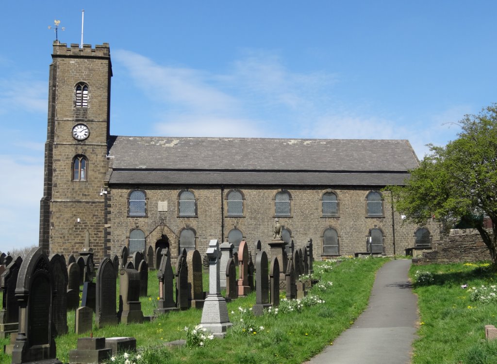
- 1844 map of Waterloo (published 1846) showing Blackburn Street, Waterloo Mill, Waterloo (main road) and Coopers Square. Samuel & Alice lived at Waterloo in 1841, as well as Isaac and other famioly members at Coopers Square, Simpson Street.
1 Coopers Square is a house in England and is located at latitude 53.578493, longitude -2.429953.
-
Place Additional Information
Place Notes
Coopers Square is between Simpson Street and Warerloo, Little Bol;ton (see map)
1 Lore Street
1 Lore Street is a house in England and is located at latitude 53.382343, longitude -3.022206.
-
Place Additional Information
1 Messiah Street
1 Messiah Street is a house in England and is located at latitude 53.578493, longitude -2.429953.
-
Place Additional Information
1 Simpson Street
- Picture Notes
- 1844 map of Waterloo (published 1846) showing Blackburn Street, Waterloo Mill, Waterloo (main road) and Coopers Square. Samuel & Alice lived at Waterloo in 1841, as well as Isaac and other famioly members at Coopers Square, Simpson Street.
1 Simpson Street is a house in England and is located at latitude 53.578493, longitude -2.429953.
-
Place Additional Information
Place Notes
Simpson Street and Coopers Square are on the corner of Waterloo and Blackburn Street. The Jolly Crofter's Inn was at the corner of the two roads.
1 Tunnel Road
1 Tunnel Road is a house in England and is located at latitude 53.382343, longitude -3.022206.
-
Place Additional Information
1 Wellington Buildings
1 Wellington Buildings is a house in England and is located at latitude 53.578493, longitude -2.429953.
-
Place Additional Information
10 Pennington Road
10 Pennington Road is a house in England and is located at latitude 53.578493, longitude -2.429953.
-
Place Additional Information
Place Notes
Bolton or Great Bolton (see also Little Bolton)
In 1773, Bolton-le-Moors was an unenclosed Moor of about 250 acres. Great and Little Bolton were mainly rural areas with only 5,339 inhabitants living in 1,178 houses.
Little Bolton was separated from Great Bolton by the River Croal. Little Bolton consisted chiefly of Turton Street, Kay Street, Bark Street and Chorley Street with a few odd houses and folds. The town was ill paved, unlit and partly drained by open gutters. There was no water supply, but the cellars of houses would often contain a pump or well. The Old Dungeon stood on windy bank, now Bank Street. A house for the poor was erected in 1785.
The main industries were spinning and weaving – fustians and cotton velveteens. In 1768, of 143 Methodists. 100 were spinners, the others being warpers, crofters, carders, sizers and winders. People would often have a sideline such as cow-keeping or farming.
John Kay, of Bury, invented the fly shuttle in 1733 which prepared the way for James Hargreaves’s Spinning Jenny in 1767. In 1769, Richard Arkwright gave up wig making to develop the water spinning frame. Then, in 1769, James Watts used a condensing steam engine to drive the coming mills created by Samuel Crompton’s mule. This revolutionised spinning and laid the foundation for the growth of Bolton.
The roads in Lancashire in the middle of the eighteenth century were poor, with wheeled traffic was impossible and so everything was carried by packhorse. About 1780, a stagecoach was started between Bolton and Carlisle, which was probably transported the Mather families of Preston to Bolton at this time. Soon, coaches connected Bolton and Manchester, running several times a day. Also there were daily coaches to London and Edinburgh. The canal opened in 1791 sending goods and passengers to Oldfield Lane, Manchester.
10 Shaw St
10 Shaw St is a house in England and is located at latitude 53.578493, longitude -2.429953.
-
Place Additional Information
10 Vine Street
10 Vine Street is a house in England and is located at latitude 53.406667, longitude -2.141304.
Place Notes
Hazel Grove is a suburb of Stockport, Greater Manchester.
104 Opic Street
104 Opic Street is a house in England and is located at latitude 53.410862, longitude -2.977467.
-
Place Additional Information
107 Field Street
107 Field Street is a house in England and is located at latitude 53.410862, longitude -2.977467.
-
Place Additional Information
Place Notes
Home of Richard Timmis (in Everton, Liverpool)
11 Canal Road
11 Canal Road is a house in England and is located at latitude 53.859943, longitude -1.842785.
Place Notes
Home town of the Smith families, including Sarah Pickles/Pighills, who gave birth to daughter Jane here.
In 1821, CROSSFLATTS, is a hamlet in the township and parish of Bingley; 1 mile NW. of Bingley, 7 from Bradford."
Crossflatts is in Micklethwaite, just North of Bingley. On the 1861 census, Houses in Crossflatts and Lime Kiln appeared on the same page, confirming the close proximity. Crossflatts still exists as a village today, but was probably a hamlet of just a few houses in 1841-51..
11 Chapel Street (Bird in Hand)
11 Chapel Street (Bird in Hand) is a house in England and is located at latitude 53.382343, longitude -3.022206.
-
Place Additional Information
Place Notes
Home of George and Esther Brereton in 1901.
The Bird in Hand was a small public house. Les's only recollection of seeing it, was whem the street was being demolished. It was small as the rooms seemed no bigger than the size of rooms in a conventional house. It could have been a house prior to being a pub.
It's believed Chapel Street was street situated between Cleveland Street and Price Street. The best way to describe it would be if you took a map of Birkenhead and located Hamilton Square and with your back to the Town Hall and looked across the square. If you go one street behind the Square on a modern map you have a street called Hamilton Lane. That is roughly where Chapel Street was.
We will confirm this when we find a map with the details on.
112 Arthur Street
112 Arthur Street is a house in England and is located at latitude 53.382343, longitude -3.022206.
-
Place Additional Information
Place Notes
Home of Alfred, Mary, Marjorie and John R Nugent in 1939
114 Arthur Street
114 Arthur Street is a house in England and is located at latitude 53.382343, longitude -3.022206.
-
Place Additional Information
114 Chorley Street
114 Chorley Street is a house in England and is located at latitude 53.578493, longitude -2.429953.
-
Place Additional Information
116 Chorley Street
116 Chorley Street is a house in England and is located at latitude 53.578493, longitude -2.429953.
-
Place Additional Information
12 Barlow St
12 Barlow St is a house in England and is located at latitude 53.578493, longitude -2.429953.
-
Place Additional Information
Place Notes
Home of John Mather, the overlooker at Looms and his wife Jane and family in 1841 and 1851. Barlow St is in Little Bolton St John..
12 Bk Haigh Street
12 Bk Haigh Street is a house.
12 Brook St
- References (1)
- 1902 Occupancy/Contact: primary residence Harry Bayley (Jul 1902 - )
12 Chapel Street
12 Chapel Street is a house in England and is located at latitude 53.382343, longitude -3.022206.
-
Place Additional Information
- References (3)
- Parent Place: Birkenhead
- 1857 Occupancy/Contact: primary residence Richard Brereton (<1857 - 1861)
- 1861 Occupancy/Contact: primary residence Alice Hopwood, Arthur Howell Hopwood, Richard Brereton, Esther Eddowes, John Brereton, George (Teapot) Brereton, Ann Brereton, Mary Whitfield, Thomas Eddowes, Mary Ann Hughes, William Eddowes, Matthew Eddowes (1861 - )
12 Grange Av
12 Grange Av is a house in England and is located at latitude 53.48018, longitude -2.236404.
-
Place Additional Information
12 Pike Street
12 Pike Street is a house.
121 Chorley Old Road
121 Chorley Old Road is a house in England and is located at latitude 53.593524, longitude -2.462654.
-
Place Additional Information
121 Kings Lane
- References (1)
- 1959 Occupancy/Contact: primary residence John Brereton ( - Jul 1959)
124 Lever Street
124 Lever Street is a house in England and is located at latitude 53.795176, longitude -1.749573.
127 Knowsley Road
127 Knowsley Road is a house in England and is located at latitude 53.452078, longitude -2.736969.
-
Place Additional Information
128 Belmont Road
128 Belmont Road is a house in England and is located at latitude 53.59821, longitude -2.427034.
-
Place Additional Information
128 Dowry St
128 Dowry St is a house.
13 Brill Street
13 Brill Street is a house in England and is located at latitude 53.382343, longitude -3.022206.
-
Place Additional Information
13 Newlon Street
13 Newlon Street is a house in England and is located at latitude 53.578493, longitude -2.429953.
-
Place Additional Information
130 Weston St
130 Weston St is a house in England and is located at latitude 53.578493, longitude -2.429953.
-
Place Additional Information
134 Noble St
134 Noble St is a house in England and is located at latitude 53.578493, longitude -2.429953.
-
Place Additional Information
135 Church Lane
135 Church Lane is a house in England and is located at latitude 53.48018, longitude -2.236404.
-
Place Additional Information
14 Brougham Street
14 Brougham Street is a house in England and is located at latitude 53.382343, longitude -3.022206.
-
Place Additional Information
14 Derby Road
14 Derby Road is a house in England and is located at latitude 53.382343, longitude -3.022206.
-
Place Additional Information
14 George St
14 George St is a house in England and is located at latitude 53.382343, longitude -3.022206.
-
Place Additional Information
14 Rishton Lane
14 Rishton Lane is a house in England and is located at latitude 53.578493, longitude -2.429953.
-
Place Additional Information
141 Holland Street
141 Holland Street is a house in England and is located at latitude 53.59821, longitude -2.427034.
-
Place Additional Information
15 Victoria Avenue
15 Victoria Avenue is a house in England and is located at latitude 53.868421, longitude -1.90836.
15 Well Street
15 Well Street is a house in England and is located at latitude 53.859943, longitude -1.842785.
Place Notes
Home town of the Smith families, including Sarah Pickles/Pighills, who gave birth to daughter Jane here.
In 1821, CROSSFLATTS, is a hamlet in the township and parish of Bingley; 1 mile NW. of Bingley, 7 from Bradford."
Crossflatts is in Micklethwaite, just North of Bingley. On the 1861 census, Houses in Crossflatts and Lime Kiln appeared on the same page, confirming the close proximity. Crossflatts still exists as a village today, but was probably a hamlet of just a few houses in 1841-51..
152 Brook Street
152 Brook Street is a house in England and is located at latitude 53.382343, longitude -3.022206.
-
Place Additional Information
Place Notes
In 1821, the population was 200, and by 1831 it was 2,569. The first Town Hall and market hall was opened in Hamilton Street in 1835. In 1840 the Birkenhead to Chester railway was opened and in 1843 work started on Birkenhead Park.
By 1846 the population increased to 40,000 but then the dock scheme failed, there was a slump and thousands left.
The 1860’s proved to be the start of a renewal of Birkenhead’s fortune. The first tramway service to be run in Europe was inaugurated here and ran from Woodside to Birkenhead Park. Birkenhead elected its first M.P. John Laird, William’s son. John Laird provided the money for the building of the Borough Hospital. The first workhouse was built and the first purpose built library opened. Following many years of petitions and deputation’s Birkenhead became a Borough on 13 August 1877.
The first election took place on 14 November 1877, the first mayor to be elected was John Laird.
156 Cathcart St.
156 Cathcart St. is a house in England and is located at latitude 53.382343, longitude -3.022206.
-
Place Additional Information
167 Lever Street
167 Lever Street is a house in England and is located at latitude 53.578493, longitude -2.429953.
-
Place Additional Information
168 Conway Street
168 Conway Street is a house in England and is located at latitude 53.382343, longitude -3.022206.
-
Place Additional Information
17 Commission St
17 Commission St is a house in England and is located at latitude 53.578493, longitude -2.429953.
-
Place Additional Information
17 Malvern Grove
17 Malvern Grove is a house in England and is located at latitude 53.382343, longitude -3.022206.
-
Place Additional Information
Place Notes
In 1821, the population was 200, and by 1831 it was 2,569. The first Town Hall and market hall was opened in Hamilton Street in 1835. In 1840 the Birkenhead to Chester railway was opened and in 1843 work started on Birkenhead Park.
By 1846 the population increased to 40,000 but then the dock scheme failed, there was a slump and thousands left.
The 1860’s proved to be the start of a renewal of Birkenhead’s fortune. The first tramway service to be run in Europe was inaugurated here and ran from Woodside to Birkenhead Park. Birkenhead elected its first M.P. John Laird, William’s son. John Laird provided the money for the building of the Borough Hospital. The first workhouse was built and the first purpose built library opened. Following many years of petitions and deputation’s Birkenhead became a Borough on 13 August 1877.
The first election took place on 14 November 1877, the first mayor to be elected was John Laird.
17 Marion Grove
17 Marion Grove is a house in England and is located at latitude 53.382343, longitude -3.022206.
-
Place Additional Information
18 George Street
18 George Street is a house in England and is located at latitude 53.382343, longitude -3.022206.
-
Place Additional Information
18 Lightfoot Street
18 Lightfoot Street is in England and is located at latitude 53.194824, longitude -2.891464.
Place Notes
Samuel Stocks was boarding at 18 Lightfoot Street, Hoole, Chester in 1911 with Timothy and Sarah Ridley and family.
18 Vine Terrace
18 Vine Terrace is a house in England and is located at latitude 53.48018, longitude -2.236404.
-
Place Additional Information
186 Belmont Road
186 Belmont Road is a house in England and is located at latitude 53.59821, longitude -2.427034.
-
Place Additional Information
19 Pleasant St
19 Pleasant St is a house in England and is located at latitude 53.578493, longitude -2.429953.
-
Place Additional Information
19 Shaw Street
19 Shaw Street is a house in England and is located at latitude 53.578493, longitude -2.429953.
-
Place Additional Information
19 Simpson Street
19 Simpson Street is a house in England and is located at latitude 53.578493, longitude -2.429953.
-
Place Additional Information
194 Peel Street
194 Peel Street is a house in England and is located at latitude 53.382343, longitude -3.022206.
-
Place Additional Information
199 Athol Street
199 Athol Street is a house in England and is located at latitude 53.410862, longitude -2.977467.
-
Place Additional Information
2 Chapel Street
2 Chapel Street is a house in England and is located at latitude 53.859943, longitude -1.842785.
Place Notes
Home town of the Smith families, including Sarah Pickles/Pighills, who gave birth to daughter Jane here.
In 1821, CROSSFLATTS, is a hamlet in the township and parish of Bingley; 1 mile NW. of Bingley, 7 from Bradford."
Crossflatts is in Micklethwaite, just North of Bingley. On the 1861 census, Houses in Crossflatts and Lime Kiln appeared on the same page, confirming the close proximity. Crossflatts still exists as a village today, but was probably a hamlet of just a few houses in 1841-51..
2 Clarence Court
2 Clarence Court is a house in England and is located at latitude 53.578493, longitude -2.429953.
-
Place Additional Information
2 Egerton Park
2 Egerton Park is a house in England and is located at latitude 53.382343, longitude -3.022206.
-
Place Additional Information
2 Great Nelson Street
2 Great Nelson Street is a house in England and is located at latitude 53.410862, longitude -2.977467.
-
Place Additional Information
2 Harner Street
2 Harner Street is a house.
- References (1)
- 1901 Occupancy/Contact: primary residence John Henry Doxey, Henry Doxey, Mary Ann Dooley, Frank Doxey, Hannah Doxey, Joseph Doxey, Sarah Elizabeth Doxey, Florence May Doxey, Clara Doxey, James Fidler, Sarah Ann Fidler, Thomas Fidler, Martha Ann Fidler, James Fidler, Henry Fidler, Alfred Fidler, Emma Fidler (1901 - 1906)
2 Nuttall Square (off Blackburton Rd)
2 Nuttall Square (off Blackburton Rd) is a house in England and is located at latitude 53.578493, longitude -2.429953.
-
Place Additional Information
2 Simpson Street
- Picture Notes
- 1844 map of Waterloo (published 1846) showing Blackburn Street, Waterloo Mill, Waterloo (main road) and Coopers Square. Samuel & Alice lived at Waterloo in 1841, as well as Isaac and other famioly members at Coopers Square, Simpson Street.
2 Simpson Street is a house in England and is located at latitude 53.578493, longitude -2.429953.
-
Place Additional Information
2+4 Nobel St, Royal Tiger (Pub)
2+4 Nobel St, Royal Tiger (Pub) is a house in England and is located at latitude 53.578493, longitude -2.429953.
-
Place Additional Information
20 Princess St
20 Princess St is a house in England.
-
Place Additional Information
200 Price St
200 Price St is a house in England and is located at latitude 53.382343, longitude -3.022206.
-
Place Additional Information
204 Kay Street
204 Kay Street is a house in England and is located at latitude 53.578493, longitude -2.429953.
-
Place Additional Information
205 Price St
205 Price St is a house in England and is located at latitude 53.382343, longitude -3.022206.
-
Place Additional Information
208+210 Pikes Lane
208+210 Pikes Lane is a house in England and is located at latitude 53.578493, longitude -2.429953.
-
Place Additional Information
21 Peel Streey
21 Peel Streey is a house in England and is located at latitude 53.845235, longitude -1.836605.
Place Notes
Home town of the Smith families, including Sarah Pighills.
21 William St
21 William St is in England and is located at latitude 53.382343, longitude -3.022206.
-
Place Additional Information
212 Town Lane

- Picture Notes
- A picture of the back garden, with the grenhouse still standing, and perfect lawn, before the gaurage was built.
Probably taken about 1958-9 when I was 3 to 4 (as I can be seen in picture with tircycle).
212 Town Lane is a house in England and is located at latitude 53.353676, longitude -3.024416.
Place Notes
Home of Joan, Walter and John Mather
22 Kelly Row
22 Kelly Row is a house in England and is located at latitude 53.578493, longitude -2.429953.
-
Place Additional Information
22 Turton Street
22 Turton Street is a house in England and is located at latitude 53.578493, longitude -2.429953.
-
Place Additional Information
Place Notes
A shop, where John Ward was a Shopkeeper in 1843
23 Grant Street
23 Grant Street is a house in England and is located at latitude 53.59821, longitude -2.427034.
-
Place Additional Information
23 Morpeth Buildings
23 Morpeth Buildings is a house in England and is located at latitude 53.382343, longitude -3.022206.
-
Place Additional Information
24 Chapel Street
24 Chapel Street is a house in England and is located at latitude 53.382343, longitude -3.022206.
-
Place Additional Information
Place Notes
In 1821, the population was 200, and by 1831 it was 2,569. The first Town Hall and market hall was opened in Hamilton Street in 1835. In 1840 the Birkenhead to Chester railway was opened and in 1843 work started on Birkenhead Park.
By 1846 the population increased to 40,000 but then the dock scheme failed, there was a slump and thousands left.
The 1860’s proved to be the start of a renewal of Birkenhead’s fortune. The first tramway service to be run in Europe was inaugurated here and ran from Woodside to Birkenhead Park. Birkenhead elected its first M.P. John Laird, William’s son. John Laird provided the money for the building of the Borough Hospital. The first workhouse was built and the first purpose built library opened. Following many years of petitions and deputation’s Birkenhead became a Borough on 13 August 1877.
The first election took place on 14 November 1877, the first mayor to be elected was John Laird.
25 Dove Street
25 Dove Street is a house.
25 Kenworthy Street
25 Kenworthy Street is a house in England and is located at latitude 53.476809, longitude -2.057362.
250 Waterloo St
250 Waterloo St is a house in England and is located at latitude 53.578493, longitude -2.429953.
-
Place Additional Information
Place Notes
Bolton or Great Bolton (see also Little Bolton)
In 1773, Bolton-le-Moors was an unenclosed Moor of about 250 acres. Great and Little Bolton were mainly rural areas with only 5,339 inhabitants living in 1,178 houses.
Little Bolton was separated from Great Bolton by the River Croal. Little Bolton consisted chiefly of Turton Street, Kay Street, Bark Street and Chorley Street with a few odd houses and folds. The town was ill paved, unlit and partly drained by open gutters. There was no water supply, but the cellars of houses would often contain a pump or well. The Old Dungeon stood on windy bank, now Bank Street. A house for the poor was erected in 1785.
The main industries were spinning and weaving – fustians and cotton velveteens. In 1768, of 143 Methodists. 100 were spinners, the others being warpers, crofters, carders, sizers and winders. People would often have a sideline such as cow-keeping or farming.
John Kay, of Bury, invented the fly shuttle in 1733 which prepared the way for James Hargreaves’s Spinning Jenny in 1767. In 1769, Richard Arkwright gave up wig making to develop the water spinning frame. Then, in 1769, James Watts used a condensing steam engine to drive the coming mills created by Samuel Crompton’s mule. This revolutionised spinning and laid the foundation for the growth of Bolton.
The roads in Lancashire in the middle of the eighteenth century were poor, with wheeled traffic was impossible and so everything was carried by packhorse. About 1780, a stagecoach was started between Bolton and Carlisle, which was probably transported the Mather families of Preston to Bolton at this time. Soon, coaches connected Bolton and Manchester, running several times a day. Also there were daily coaches to London and Edinburgh. The canal opened in 1791 sending goods and passengers to Oldfield Lane, Manchester.
259 Church Street
259 Church Street is a house in England and is located at latitude 53.578493, longitude -2.429953.
-
Place Additional Information
26 Olive Street
26 Olive Street is a house in England.
26 Shaw St
26 Shaw St is a house in England and is located at latitude 53.578493, longitude -2.429953.
-
Place Additional Information
27 Berry St
27 Berry St is a house.
27 Halliwell Road
27 Halliwell Road is a house in England and is located at latitude 53.578493, longitude -2.429953.
-
Place Additional Information
27 Marion St
27 Marion St is a house.
27 Park Road
27 Park Road is a house in England and is located at latitude 52.774109, longitude -1.204376.
278 Dean Church Lane
278 Dean Church Lane is a house in England and is located at latitude 53.567153, longitude -2.463942.
-
Place Additional Information
282+284 St. Ann Street
282+284 St. Ann Street is a house in England and is located at latitude 53.382343, longitude -3.022206.
-
Place Additional Information
284 St. Ann Street
284 St. Ann Street is a house in England and is located at latitude 53.382343, longitude -3.022206.
-
Place Additional Information
29 Major Street
29 Major Street is a house in England and is located at latitude 53.578493, longitude -2.429953.
-
Place Additional Information
3 Cockton Hill Terrace
3 Cockton Hill Terrace is a house in England.
3 Rivington St
3 Rivington St is a house.
3 Russell Place
3 Russell Place is a house in England and is located at latitude 53.382343, longitude -3.022206.
-
Place Additional Information
3 Yates Square
3 Yates Square is a house in England and is located at latitude 53.578493, longitude -2.429953.
-
Place Additional Information
30 Anglia Grove
30 Anglia Grove is a house in England and is located at latitude 53.578493, longitude -2.429953.
-
Place Additional Information
30 Back Grosvener St
30 Back Grosvener St is a house in England and is located at latitude 53.476809, longitude -2.057362.
30 Chapel Street
30 Chapel Street is a house in England and is located at latitude 53.382343, longitude -3.022206.
-
Place Additional Information
30 Chorley Street
30 Chorley Street is a house.
30 Eldon Place
30 Eldon Place is a house in England and is located at latitude 53.382343, longitude -3.022206.
-
Place Additional Information
30 Howard Street
30 Howard Street is a house in England and is located at latitude 53.578493, longitude -2.429953.
-
Place Additional Information
304 Beckwith Street
304 Beckwith Street is a house in England and is located at latitude 53.382343, longitude -3.022206.
-
Place Additional Information
31 Mile Street
31 Mile Street is a house in England and is located at latitude 53.578493, longitude -2.429953.
-
Place Additional Information
32 Camden Street
32 Camden Street is a house in England and is located at latitude 53.382343, longitude -3.022206.
-
Place Additional Information
32 Commission Street

- Picture Notes
- East Bolton showing Christ Church and St Paul Deansgate & Emmanuel Churches etc
32 Commission Street is a house in England and is located at latitude 53.578493, longitude -2.429953.
-
Place Additional Information
33 Blackburn Road
33 Blackburn Road is a house in England and is located at latitude 53.578493, longitude -2.429953.
-
Place Additional Information
33 Sidney Road
33 Sidney Road is a house in England and is located at latitude 53.382343, longitude -3.022206.
-
Place Additional Information
Place Notes
in 1911 William Martin Harnman, wife Emily and children Emily (18), Lily (17), William Arthur (15) and George Henry (14) wre living at 33 Sidney Street, Lower Tranmere, but I cant find Samuel Stocks living anywhere! Probably as the Harnman daughters married and left home, they had space for a lodger and Samuel moved in as his final address before he died.
335 Droylsden Road
335 Droylsden Road is a house in England and is located at latitude 53.48018, longitude -2.236404.
-
Place Additional Information
Place Notes
Home of John, Lily, Lawrence and Olive in 1939. House on the corner of Hulme Road.
34 Bankburn Road
34 Bankburn Road is a house.
34 Cleveland Street
34 Cleveland Street is a house.
34 Crook Street

- Picture Notes
- Crook Steet, Sidney Street, SE Bolton
34 Crook Street is a house in England and is located at latitude 53.578493, longitude -2.429953.
-
Place Additional Information
- References (2)
- Parent Place: Bolton
- 1838 Occupancy/Contact: primary residence Mary Crook, John Buckley, John Mather, Mary Buckley, Benjamin Buckley, Margaret Miller, Cornelius Buckley, William Buckley, Joseph Buckley, James Buckley, John Mather (<1838 - >1851)
34 Hemmons Road
34 Hemmons Road is a house in England and is located at latitude 53.48018, longitude -2.236404.
-
Place Additional Information
Place Notes
Richard, Lilly, Alice and Joseph were living at 34 Hemmons Road, Manchester in 1939
34 Isabel St
34 Isabel St is a house in England and is located at latitude 53.518931, longitude -2.243958.
-
Place Additional Information
Place Notes
Described as Yorkshire in 1781 and 1791, but suburb of Manchester in present day.
34 Shaw Street
34 Shaw Street is a house.
34 Vine Street
34 Vine Street is a house in England and is located at latitude 53.382343, longitude -3.022206.
-
Place Additional Information
34+36+38 St Ann Street
34+36+38 St Ann Street is a house in England and is located at latitude 53.382343, longitude -3.022206.
-
Place Additional Information
342 Beckwith Street
342 Beckwith Street is a house in England and is located at latitude 53.382343, longitude -3.022206.
-
Place Additional Information
345 Church Street
345 Church Street is a house in England and is located at latitude 53.578493, longitude -2.429953.
-
Place Additional Information
35 Beckett St
35 Beckett St is a house in England and is located at latitude 53.593524, longitude -2.462654.
-
Place Additional Information
37 Devonshire Road
37 Devonshire Road is a house in England and is located at latitude 53.350551, longitude --3.046646.
Place Notes
Home of the Dittmer family from 1930. Harry, Elsie, Harry jnr, Joan and Clifford were all recorded there on the 1939 register.
37 North Road
37 North Road is a house in England.
-
Place Additional Information
38 Sumner Road
38 Sumner Road is a house in England and is located at latitude 53.382343, longitude -3.022206.
-
Place Additional Information
Place Notes
Home of William J, Emmeline, William R and Hilary in 1939
389 New Chester Road
389 New Chester Road is a house in England and is located at latitude 53.382343, longitude -3.022206.
-
Place Additional Information
39 Halsey Crescent
39 Halsey Crescent is a house in England and is located at latitude 53.410862, longitude -2.977467.
-
Place Additional Information
39 Hemingford Street
39 Hemingford Street is a house.
39 Hilton Street
39 Hilton Street is a house in England and is located at latitude 53.382343, longitude -3.022206.
-
Place Additional Information
39 Mallory Road
39 Mallory Road is a house in England and is located at latitude 53.382343, longitude -3.022206.
-
Place Additional Information
4 Baron Street
4 Baron Street is a house.
4 Brunswick Road
4 Brunswick Road is a house in England.
4 Farm Road
4 Farm Road is a house in England and is located at latitude 53.382343, longitude -3.022206.
-
Place Additional Information
4 Fox Street
4 Fox Street is a house in England and is located at latitude 53.382343, longitude -3.022206.
-
Place Additional Information
4 Gleave Street
4 Gleave Street is a house in England and is located at latitude 53.578493, longitude -2.429953.
-
Place Additional Information
4 Harthill Village
4 Harthill Village is a house in England.
4 Laburnum St
4 Laburnum St is a house in England and is located at latitude 53.578493, longitude -2.429953.
-
Place Additional Information
4 Morpeth Building
4 Morpeth Building is a house in England and is located at latitude 53.382343, longitude -3.022206.
-
Place Additional Information
4 Shaw's Place
4 Shaw's Place is a house in England and is located at latitude 53.382343, longitude -3.022206.
-
Place Additional Information
4 Simpson Street
- Picture Notes
- 1844 map of Waterloo (published 1846) showing Blackburn Street, Waterloo Mill, Waterloo (main road) and Coopers Square. Samuel & Alice lived at Waterloo in 1841, as well as Isaac and other famioly members at Coopers Square, Simpson Street.
4 Simpson Street is a house in England and is located at latitude 53.578493, longitude -2.429953.
-
Place Additional Information
Place Notes
Family home of Samuel and Alice Mather. Simpson Street and Coopers Square are on the corner of Waterloo and Blackburn Street. The Jolly Crofter's Inn was at the corner of the two roads.
4 Wellington Terrace
4 Wellington Terrace is a house in England and is located at latitude 53.382343, longitude -3.022206.
-
Place Additional Information
4 West Dulce Street
4 West Dulce Street is a house in England and is located at latitude 53.48018, longitude -2.236404.
-
Place Additional Information
40 Kenworthy Street
40 Kenworthy Street is a house in England and is located at latitude 53.476809, longitude -2.057362.
40 Mather Road
40 Mather Road is a house in England and is located at latitude 53.382343, longitude -3.022206.
-
Place Additional Information
409 Brook Street
409 Brook Street is a house in England and is located at latitude 53.382343, longitude -3.022206.
-
Place Additional Information
42 Barrage Street
42 Barrage Street is a house in England and is located at latitude 53.845235, longitude -1.836605.
Place Notes
Home town of the Smith families, including Sarah Pighills.
42 Guide Lane
42 Guide Lane is a house in England and is located at latitude 53.48018, longitude -2.236404.
-
Place Additional Information
Place Notes
Ashton-under-Lyne, Audenshaw and Dukinfield are adjacent (joined) market towns in Tameside, Greater Manchester. Ashton is on the North side of the River Tame, 6 miles east of Manchester, and Audenshaw and Dukinfield on the South.
43 Cornwallis Street
43 Cornwallis Street is a house in England and is located at latitude 53.410862, longitude -2.977467.
-
Place Additional Information
44 Epsom St
44 Epsom St is a house in England and is located at latitude 53.410862, longitude -2.977467.
-
Place Additional Information
44 Upper Brassy St
44 Upper Brassy St is a house in England and is located at latitude 53.382343, longitude -3.022206.
-
Place Additional Information
45 Ascot Street
45 Ascot Street is a house in England and is located at latitude 53.410862, longitude -2.977467.
-
Place Additional Information
45 Thompson St.

- Picture Notes
- Auntie Norah can be seen at the gates of Thompson Street. The Iron railings were removed during the war, dating this photo pre-War.

- Picture Notes
- Gran, pictured in the big greenhouse in Thmpson Street. They produces many tomatos for the local community. There was also a smaller greenhouse.
45 Thompson St. is a house in England and is located at latitude 53.382343, longitude -3.022206.
-
Place Additional Information
Place Notes
The Mather family lived at 45 Thompson St, a big 4-bed house on a corner plot, with living room, large front-aspect dining room (big enough for 20+), kitchen with black-iron fireplace and ovens on either side, lower scullery and wash room. There were coal bunkers, WC and garage outside. It had a large Victorian garden with raised flower beds, vegetable plot around the side and two large glass-houses. An amazing old house!
- References (30)
- Parent Place: Tranmere
- Individual: John Mather
- Picture: John R Mather
- Picture: John and Sarah Mather
- Picture: Grans 80th Birthday
- Picture: Granma Mather
- Picture: Eilene Mather
- Picture: 1967 Albert Mather
- Picture: 1960 Albert Mather
- Picture: John (Jack) Mather
- Picture: 1960 Jack Mather
- Picture: Joyce Mather
- Picture: John Graham (Big John) and Julie
- Picture: 1967 Aunt Polly
- Picture: The Mather Tribe
- Picture: Nell Mather & Arthur Bayley Wedding
- Picture: 45 Thompson St
- Picture: Mum, Dad, John and Snowy
- Picture: Nellie, Les & Jessie Mather
- Picture: Gran, Norah and Betty
- Picture: Jane Stocks
- Picture: Joan Mather
- Picture: Jessie Mather
- Picture: Albert Stocks
- 1909 Occupancy/Contact: primary residence Sarah Stocks, John Mather, Joseph (Joe) Mather, Eileen (Lean) Mather, Jessie (Jess) Mather, Norah (No) Mather, Albert (Ab) Mather, John (Jack) Mather (1909 - )
- 1909 Occupancy/Contact: primary residence Walter (Wal) Mather (1909 - 1949)
- 1911 Occupancy/Contact: primary residence Albert Stocks, Jane Smith, Walter Stocks, Minnie (Lilly) Stocks (<1911 - Jan 1928)
- 1931 Occupancy/Contact: primary residence Joseph (Joe) Mather (1931 - )
- 1939 Occupation: Domestic Duties Jessie (Jess) Mather (<1939 - )
- 1939 Occupation: Domestic Duties Sarah Stocks (<1939 - )
46 Church Street
46 Church Street is a house in England and is located at latitude 53.382343, longitude -3.022206.
-
Place Additional Information
48 Brassey Street
48 Brassey Street is a house in England and is located at latitude 53.382343, longitude -3.022206.
-
Place Additional Information
5 Cobden Street
5 Cobden Street is a house in England and is located at latitude 53.382343, longitude -3.022206.
-
Place Additional Information
5 Empire St
5 Empire St is a house in England and is located at latitude 53.410862, longitude -2.977467.
-
Place Additional Information
5 Frog Lane, Ludlow
5 Frog Lane, Ludlow is a house in England and is located at latitude 52.367896, longitude -2.717485.
5 Junction Rd
5 Junction Rd is a house in England and is located at latitude 53.567153, longitude -2.463942.
-
Place Additional Information
5 Nell Street
5 Nell Street is a house in England and is located at latitude 53.59821, longitude -2.427034.
-
Place Additional Information
5 Primrose Hill
5 Primrose Hill is a house in England and is located at latitude 53.845235, longitude -1.836605.
Place Notes
Home town of the Smith families, including Sarah Pighills.
5 Waterloo Fold
5 Waterloo Fold is a house in England and is located at latitude 53.578493, longitude -2.429953.
-
Place Additional Information
5 West View
- References (1)
- 1881 Occupancy/Contact: primary residence Jane Mather (1881 - )
50 Meadow Lane
50 Meadow Lane is a house in England and is located at latitude 53.382343, longitude -3.022206.
-
Place Additional Information
51 Halliwell Road
51 Halliwell Road is a house in England and is located at latitude 53.578493, longitude -2.429953.
-
Place Additional Information
52 Vine Street
52 Vine Street is a house in England and is located at latitude 53.382343, longitude -3.022206.
-
Place Additional Information
56 Chrich Street
56 Chrich Street is a house in England and is located at latitude 53.382343, longitude -3.022206.
-
Place Additional Information
56 Mossman Street
56 Mossman Street is a house in England and is located at latitude 53.795176, longitude -1.749573.
57 Cameron Street
57 Cameron Street is a house in England and is located at latitude 53.59821, longitude -2.427034.
-
Place Additional Information
57 George Street
57 George Street is a house in England and is located at latitude 53.382343, longitude -3.022206.
-
Place Additional Information
57 John St
57 John St is a house in England and is located at latitude 53.578493, longitude -2.429953.
-
Place Additional Information
58 Chorley Street
58 Chorley Street is a house in England and is located at latitude 53.578493, longitude -2.429953.
-
Place Additional Information
6 Bar Lane
6 Bar Lane is a house in England and is located at latitude 53.59821, longitude -2.427034.
-
Place Additional Information
6 Doctor Lane

- Picture Notes
- Picture taken by Mun and Dad before Dad was Ill, about 1998
6 Doctor Lane is a house in England and is located at latitude 53.812258, longitude -1.709146.
Place Notes
A little road trapped in time. This was the home of Henry and Freda Dittmer before Freda died. Mum, Nan and family used to visit for there for their holidays. Mum and Dad last visited about 1998 and found Mrs Alice Nutter, an old friend, still living next door.
6 Lincoln Avenue
6 Lincoln Avenue is a house in England and is located at latitude 53.48018, longitude -2.236404.
-
Place Additional Information
6 Lower Mill Street
6 Lower Mill Street is a house in England and is located at latitude 52.367896, longitude -2.717485.
6 Mardence(?) Place
6 Mardence(?) Place is a house in England and is located at latitude 53.845235, longitude -1.836605.
Place Notes
Home town of the Smith families, including Sarah Pighills.
6 Nelson Street
6 Nelson Street is a house in England and is located at latitude 53.406667, longitude -2.141304.
Place Notes
Hazel Grove is a suburb of Stockport, Greater Manchester.
6 Old Loran
6 Old Loran is a house in England and is located at latitude 53.620819, longitude -2.400856.
-
Place Additional Information
6 Tengrove Street
6 Tengrove Street is a house in England.
-
Place Additional Information
Place Notes
6 Tengrove Street, is in the sub-district of Spotland and Norden
6+7 Coffin Row, Eastburn, Kildwick, and Steeton
6+7 Coffin Row, Eastburn, Kildwick, and Steeton is a house in England.
63 Lambeth Road
63 Lambeth Road is a house in England.
-
Place Additional Information
63 Union Street
63 Union Street is a house in England and is located at latitude 52.287273&, longitude -2.495098.
Place Notes
Hanley was in Staffordshire in the 1800's, but now Worcestershire.
64 Baytree Road
64 Baytree Road is a house in England and is located at latitude 53.382343, longitude -3.022206.
-
Place Additional Information
65 Holt Road
65 Holt Road is a house in England and is located at latitude 53.382343, longitude -3.022206.
-
Place Additional Information
Place Notes
Home of John & Sarah Mather and family in 1911.
A Four room house including kitchen and Living rooms, (so probably only 2 or 3 bedrooms) for the 8 of them.
67 Blackbank Street
67 Blackbank Street is a house in England and is located at latitude 53.578493, longitude -2.429953.
-
Place Additional Information
67 Wentworth Street
67 Wentworth Street is a house in England and is located at latitude 53.578493, longitude -2.429953.
-
Place Additional Information
68 Chatham Road
68 Chatham Road is a house in England and is located at latitude 53.350551, longitude --3.046646.
7 Cedar St
7 Cedar St is a house in England and is located at latitude 53.578493, longitude -2.429953.
-
Place Additional Information
Place Notes
William and Mary Tomlinson's first home in Bolton, Lancashire
7 Craven Street
7 Craven Street is a house in England and is located at latitude 53.382343, longitude -3.022206.
-
Place Additional Information
7 Ellis Street
7 Ellis Street is a house in England and is located at latitude 53.859943, longitude -1.842785.
Place Notes
Home town of the Smith families, including Sarah Pickles/Pighills, who gave birth to daughter Jane here.
In 1821, CROSSFLATTS, is a hamlet in the township and parish of Bingley; 1 mile NW. of Bingley, 7 from Bradford."
Crossflatts is in Micklethwaite, just North of Bingley. On the 1861 census, Houses in Crossflatts and Lime Kiln appeared on the same page, confirming the close proximity. Crossflatts still exists as a village today, but was probably a hamlet of just a few houses in 1841-51..
7 George St
7 George St is a house in England and is located at latitude 53.382343, longitude -3.022206.
-
Place Additional Information
Place Notes
In 1821, the population was 200, and by 1831 it was 2,569. The first Town Hall and market hall was opened in Hamilton Street in 1835. In 1840 the Birkenhead to Chester railway was opened and in 1843 work started on Birkenhead Park.
By 1846 the population increased to 40,000 but then the dock scheme failed, there was a slump and thousands left.
The 1860’s proved to be the start of a renewal of Birkenhead’s fortune. The first tramway service to be run in Europe was inaugurated here and ran from Woodside to Birkenhead Park. Birkenhead elected its first M.P. John Laird, William’s son. John Laird provided the money for the building of the Borough Hospital. The first workhouse was built and the first purpose built library opened. Following many years of petitions and deputation’s Birkenhead became a Borough on 13 August 1877.
The first election took place on 14 November 1877, the first mayor to be elected was John Laird.
7 Hayden Court
7 Hayden Court is a house in England.
7 Tunnel Road
7 Tunnel Road is a house in England and is located at latitude 53.382343, longitude -3.022206.
-
Place Additional Information
7 Vine Street
7 Vine Street is a house in England and is located at latitude 53.382343, longitude -3.022206.
-
Place Additional Information
7 Woodcoate Bank
7 Woodcoate Bank is a house in England and is located at latitude 53.382343, longitude -3.022206.
-
Place Additional Information
70 Marlbow Street
70 Marlbow Street is a house.
73 Blackbank Street
73 Blackbank Street is a house in England and is located at latitude 53.578493, longitude -2.429953.
-
Place Additional Information
74 Patten St.
74 Patten St. is in England and is located at latitude 53.382343, longitude -3.022206.
-
Place Additional Information
77 Grasmere Street
77 Grasmere Street is a house in England and is located at latitude 53.578493, longitude -2.429953.
-
Place Additional Information
78 Grasmere Street
78 Grasmere Street is a house in England and is located at latitude 53.578493, longitude -2.429953.
-
Place Additional Information
78 Haydock St
78 Haydock St is a house in England.
-
Place Additional Information
79 Cobden Street
79 Cobden Street is a house in England and is located at latitude 53.382343, longitude -3.022206.
-
Place Additional Information
8 Chapel Street
8 Chapel Street is a house in England and is located at latitude 53.578493, longitude -2.429953.
-
Place Additional Information
8 Neptune Street
8 Neptune Street is a house in England and is located at latitude 53.382343, longitude -3.022206.
-
Place Additional Information
8 Reedville Road
8 Reedville Road is a house in England and is located at latitude 53.353676, longitude -3.024416.
Place Notes
Merseyside is a new County, comprising of the Wirral and areas of Lancashire and Cheshire.
8 Shaw Street
8 Shaw Street is a house in England and is located at latitude 53.578493, longitude -2.429953.
-
Place Additional Information
- References (4)
- Parent Place: Bolton
- 1841 Occupancy/Contact: primary residence Ellen Tomlinson, Ann Bolton, Alice Tomlinson, Richard Tomlinson, Joshua Tomlinson, John Bolton, William Tomlinson, John Allen, Thomas Bolton Tomlinson, Ellen Atherton, Mary Alice Atherton Tomlinson, Mary Whitaker, Mary (Polly) Tomlinson, Richard Tomlinson (1841 - )
- 1857 Individual: Richard Tomlinson (d. Dec 22nd, 1857 )
- 1861 Occupation: Cotton Weaver William Tomlinson (1861 - )
8 Spring Mill
8 Spring Mill is a house in England and is located at latitude 53.641534, longitude -1.823645.
Place Notes
Home of Rebecca Robinson before she was married to George Stocks.
Milnsbridge is just over the railway line from Longwood, where Rebecca was Christened.
Samuel & Sarah Ann Stocks moved back to 8 Spring Mill, Milnsbridge (1911 census).
81 Leicester Street
81 Leicester Street is a house in England and is located at latitude 53.578493, longitude -2.429953.
-
Place Additional Information
81 New Chester Road
81 New Chester Road is a house in England and is located at latitude 53.382343, longitude -3.022206.
-
Place Additional Information
Place Notes
In 1821, the population was 200, and by 1831 it was 2,569. The first Town Hall and market hall was opened in Hamilton Street in 1835. In 1840 the Birkenhead to Chester railway was opened and in 1843 work started on Birkenhead Park.
By 1846 the population increased to 40,000 but then the dock scheme failed, there was a slump and thousands left.
The 1860’s proved to be the start of a renewal of Birkenhead’s fortune. The first tramway service to be run in Europe was inaugurated here and ran from Woodside to Birkenhead Park. Birkenhead elected its first M.P. John Laird, William’s son. John Laird provided the money for the building of the Borough Hospital. The first workhouse was built and the first purpose built library opened. Following many years of petitions and deputation’s Birkenhead became a Borough on 13 August 1877.
The first election took place on 14 November 1877, the first mayor to be elected was John Laird.
83 Blackburn Road
83 Blackburn Road is a house in England and is located at latitude 53.578493, longitude -2.429953.
-
Place Additional Information
86 Martin Lane
86 Martin Lane is a house in England.
-
Place Additional Information
Place Notes
Home of Jim Robinson, wife Lilian and sister-in-law Alice Rothwell in 1939
89 Opic Street
89 Opic Street is a house in England and is located at latitude 53.410862, longitude -2.977467.
-
Place Additional Information
9 Grouse Street
9 Grouse Street is a house in England and is located at latitude 53.845235, longitude -1.836605.
Place Notes
Home town of the Smith families, including Sarah Pighills.
9 Nell Street
9 Nell Street is a house in England and is located at latitude 53.59821, longitude -2.427034.
-
Place Additional Information
- References (8)
- Parent Place: Astley Bridge
- 1877 Individual: Phineas Shuttleworth (b. Apr 25th, 1877 )
- 1879 Occupancy/Contact: primary residence Samuel Shuttleworth, Lois Pollitt, Miles Shuttleworth, Phineas Shuttleworth (1879 - >1881)
- 1879 Individual: Miles Shuttleworth (b. Jun 27th, 1879 )
- 1882 Individual: Happy Shuttleworth (b. Feb 6th, 1882 )
- 1884 Individual: Samuel Shuttleworth (b. Oct 11th, 1884 )
- 1887 Individual: Albert Shuttleworth (b. Jun 8th, 1887 d. Nov 6th, 1888 )
- 1889 Individual: Lois Shuttleworth (b. Oct 13th, 1889 )
9 Reade Close
9 Reade Close is a house in England and is located at latitude 53.353676, longitude -3.024416.
Place Notes
Merseyside is a new County, comprising of the Wirral and areas of Lancashire and Cheshire.
9 Well Street
9 Well Street is a house in England and is located at latitude 53.859943, longitude -1.842785.
Place Notes
Home town of the Smith families, including Sarah Pickles/Pighills, who gave birth to daughter Jane here.
In 1821, CROSSFLATTS, is a hamlet in the township and parish of Bingley; 1 mile NW. of Bingley, 7 from Bradford."
Crossflatts is in Micklethwaite, just North of Bingley. On the 1861 census, Houses in Crossflatts and Lime Kiln appeared on the same page, confirming the close proximity. Crossflatts still exists as a village today, but was probably a hamlet of just a few houses in 1841-51..
9 William St
9 William St is a house in England and is located at latitude 53.382343, longitude -3.022206.
-
Place Additional Information
93 Stanley Road
93 Stanley Road is a house in England and is located at latitude 53.410862, longitude -2.977467.
-
Place Additional Information
94 Blackburn Road
- Picture Notes
- East Bolton showing Christ Church and St Paul Deansgate & Emmanuel Churches etc
94 Blackburn Road is a house in England and is located at latitude 53.578493, longitude -2.429953.
-
Place Additional Information
97 Kay Street
97 Kay Street is a house in England and is located at latitude 53.578493, longitude -2.429953.
-
Place Additional Information
Abenbury (Fawr & Fechan)
 and sourced from NLS Maps.")
- Picture Notes
- Abenbury Fawr (or "Big Abenbury"), Denbighshire and Abenbury Fechan (or "Little Abenbury"), Flintshire and West of Abenbury Fawr are Townships of Wrexham. In 1888 they were combined as Abenbury Fawr in 1888. See https://maps.nls.uk/view/102341207
Abenbury (Fawr & Fechan) is a village in Wales.
Place Notes
The Townships of Abenbury Fechan (Little Abenbury), Flintshire detached Nos 3,4,5,6, & 8 was in 1883 & 1885 added to the Civil Parish of Abenbury Fawr, Denbighshire.
The Township of Abenbury Fawr (Big Abenbury) in Denbighshire is situated 2 miles East of Wrexham and lies North of Abenbury Fechan (Flintshire, detached). See 1872 Wrexham OS maps.
Aberdeenshire
Aberdeenshire is a county in Scotland.
Abram
Abram is in England.
-
Place Additional Information
Accrington
Accrington is in England.
-
Place Additional Information
- References (50)
- Parent Place: Blackburn
- Place: St. James (Accrington)
- 1792 Individual: Mary Taylor (b. ~1792 )
- 1795 Individual: Betty Cunliffe (b. ~1795 )
- 1796 Individual: James Cunliffe (b. 1796 )
- 1814 Individual: Henry Howarth (b. Oct 16th, 1814 bpt. Mar 26th, 1815 )
- 1815 Individual: Ann Gibson (d. Aug 2nd, 1815 )
- 1815 Individual: Elizabeth Howarth (b. Nov 20th, 1815 bpt. Jan 6th, 1816 )
- 1816 Individual: James Walsh (b. 1816 bpt. Jun 16th, 1816 )
- 1816 Marriage / Union: James Cunliffe & Jenny (Jane) Chambers (m. Dec 22nd, 1816 )
- 1817 Individual: John Mather (bpt. Sep 27th, 1817 )
- 1817 Individual: Hannah Mather (bpt. Sep 27th, 1817 )
- 1817 Individual: Betty (Eliza) Mather (bpt. Sep 27th, 1817 )
- 1819 Individual: John Cunliffe (b. 1819 )
- 1819 Individual: Martha Mather (bpt. Dec 30th, 1819 )
- 1820 Individual: Nancy Cunliffe (b. Aug 1820 )
- 1821 Individual: Thomas Walsh (b. Jan 20th, 1821 bpt. Feb 18th, 1821 )
- 1821 Individual: Sarah Mather (bpt. Dec 2nd, 1821 )
- 1823 Individual: Ben Cunliffe (b. 1823 )
- 1823 Marriage / Union: Robinson Lang & Peggy Cunliffe (m. Jun 30th, 1823 )
- 1825 Individual: James Cunliffe (b. 1825 )
- 1829 Individual: Alice Cunliffe (b. 1829 )
- 1831 Individual: Robert Cunliffe (b. 1831 )
- 1834 Individual: Henry Cunliffe (b. 1834 )
- 1834 Individual: Jonathan Peel (d. Dec 3rd, 1834 )
- 1836 Individual: Ellen Cunliffe (b. 1836 )
- 1839 Individual: Mary Cunliffe (b. Mar 1839 )
- 1852 Individual: John Omerod Cunliffe (d. 1852 )
- 1861 Occupation: Mule Spinner James Drain (1861 - )
- 1865 Individual: Sarah Ann Drain (b. Apr 27th, 1865 bpt. May 18th, 1865 )
- 1873 Occupation: General Dealer James Mather (1873 - )
- 1873 Marriage / Union: James Mather & Mary Murgatroyd (m. Feb 14th, 1873 )
- 1875 Individual: Alice Ann Mather (b. Dec 1875 )
- 1876 Individual: Ann Heaton (d. Nov 18th, 1876 )
- 1878 Individual: Herbert William Mather (b. Jun 1878 )
- 1880 Individual: George Henry Mather (b. Sep 1880 )
- 1882 Individual: John James Mather (b. Jun 1882 )
- 1884 Individual: Lilian Mather (b. Mar 1884 )
- 1884 Individual: Joseph Lee Mather (b. Jun 1884 d. 1885 )
- 1886 Individual: Albert Lee Mather (b. Sep 1886 )
- 1898 Individual: Ethel Mather (b. Mar 1898 )
- 1900 Individual: Harry Mather (b. Jun 1900 )
- 1906 Individual: George Henry Washington Mathers (d. Feb 5th, 1906 )
- 1906 Individual: James Broadley (b. Dec 19th, 1906 )
- 1907 Individual: Clarice (Olivia) Wood (b. Mar 20th, 1907 )
- 1913 Marriage / Union: Thomas Stanley Whittaker & Mary Matilda Draine (m. Jun 28th, 1913 )
- 1928 Individual: Helen Mather (b. Dec 11th, 1928 )
- 1938 Individual: Ann Sugden (d. Sep 13th, 1938 )
- 1943 Marriage / Union: Harry Cunliffe & Dorothy Watkins (m. 1943 )
- 1971 Marriage / Union: Philip John Rawcliffe & Jennifer Ann Hamer (m. Jul 1971 )
Acton by Nantwich

- Picture Notes
- OS First Series Map showing Acton by Nantwich and surrounding area (about 1830 to 1860)
Acton by Nantwich is a village in England.
Place Notes
St. Mary's is at Acton by Nantwich, Cheshire. A church has been here since the Domesday Book was written.. The current church is built of Red sandstone and old tower was rebuilt in 1757
- References (164)
- Parent Place: Nantwich
- Picture: 1820 Thomas Brereton
- Picture: 1657 Richard Brereton & Elizabeth Kendricke
- Picture: 1674 Thomas Brereton & Ann Bettiley
- Picture: 1633 Thomas Brereton (Acton)
- Picture: MAP 1840-50s Acton by Nantwich
- Place: Faddiley
- 1590 Individual: Elizabeth Webenham (b. 1590 )
- 1596 Individual: John Brereton (b. 1596 d. <1657 )
- 1610 Individual: Richard Kendricke (b. ~1610 )
- 1623 Individual: Maria Kendricke (b. 1623 )
- 1628 Marriage / Union: John Hassall & Margery Jerius (m. Mar 27th, 1628 )
- 1633 Individual: Thomas Brereton (b. Aug 1633 bpt. Aug 4th, 1633 )
- 1648 Individual: Margaret Brereton (b. Jan 14th, 1648 )
- 1657 Marriage / Union: Richard Brereton & Elizabeth Kendricke (m. Mar 12th, 1657 )
- 1658 Individual: Elizabeth Brereton (b. Oct 12th, 1658 bpt. Nov 1st, 1658 )
- 1661 Individual: Richard Brereton (b. 1661 chr. Aug 11th, 1661 d. Aug 1733 burial. Aug 12th, 1733)
- 1661 Individual: Amy Bettiley (b. 1661 bpt. Jul 15th, 1661 )
- 1663 Individual: Jonathan (John) Brereton (b. Oct 1663 chr. Oct 20th, 1663 )
- 1663 Individual: William Brereton (b. Oct 1663 chr. Oct 20th, 1663 )
- 1666 Individual: Thomas Brereton (b. Feb 1666 chr. Feb 6th, 1666 )
- 1668 Individual: Anna Brereton (b. 1668 bpt. Jan 1st, 1668 )
- 1668 Individual: Richard Cretchley (b. ~1668 )
- 1668 Individual: Mary (Maria) Hassall (d. Oct 1668 burial. Oct 5th, 1668)
- 1671 Individual: Ranalphus (Randle or Ralph) Brereton (b. Feb 20th, 1671 chr. Feb 20th, 1671 d. 1719 burial. Feb 23rd, 1719)
- 1674 Individual: Margaret Brereton (b. 1674 chr. Nov 5th, 1674 )
- 1674 Individual: Thomas Garrett (b. ~1674 )
- 1674 Marriage / Union: Thomas Brereton & Anne Bettiley (m. Jan 1st, 1674 )
- 1677 Individual: Richard Brereton (d. May 1677 burial. May 24th, 1677)
- 1677 Individual: Thomas Brereton (b. Aug 1677 chr. Aug 28th, 1677 )
- 1683 Marriage / Union: Jonathan (John) Brereton & Mary Sandford (m. Aug 24th, 1683 )
- 1695 Marriage / Union: Richard Cretchley & Anna Brereton (m. Apr 10th, 1695 )
- 1696 Individual: William Brereton (b. Oct 1696 bpt. Oct 11th, 1696 )
- 1696 Marriage / Union: Richard Brereton & Jane Roberts (m. Dec 10th, 1696 )
- 1697 Marriage / Union: Thomas Garrett & Margaret Brereton (m. Oct 3rd, 1697 )
- 1699 Individual: Sam Brereton (b. ~1699 chr. Apr 11th, 1699 )
- 1699 Individual: Thomas Brereton (b. 1699 bpt. Feb 2nd, 1699 d. 1699 burial. Jun 9th, 1699)
- 1701 Individual: Ralph Brereton (b. 1701 bpt. Apr 22nd, 1701 )
- 1703 Individual: Amy Brereton (b. 1703 bpt. Apr 19th, 1703 d. Jul 1703 burial. Jul 11th, 1703)
- 1704 Individual: John Brereton (b. 1704 bpt. Dec 17th, 1704 burial. Jun 27th, 1779)
- 1707 Individual: Anna Brereton (b. 1707 bpt. Apr 20th, 1707 burial. Jun 8th, 1770)
- 1710 Individual: Rannulphus (Randle) Brereton (b. 1710 bpt. Apr 2nd, 1710 d. Oct 1765 burial. Oct 13th, 1765)
- 1711 Individual: Maria (Mary) Blackmore (b. May 3rd, 1711 bpt. May 3rd, 1711 d. >Jan 1766 burial. Nov 18th, 1768)
- 1714 Marriage / Union: Thomas Brereton & Sarah Thestows (m. Aug 15th, 1714 )
- 1719 Marriage / Union: Thomas Brereton Jnr & Maria Allin (m. Sep 29th, 1719 )
- 1724 Individual: Elizabeth Kendricke (burial. Oct 18th, 1724)
- 1725 Individual: Randle Brereton (bpt. Mar 17th, 1725 burial. Jun 8th, 1725)
- 1726 Individual: Thomas Brereton (b. Dec 1726 bpt. Dec 26th, 1726 )
- 1730 Marriage / Union: William Brereton & Sarah Shelley (m. Sep 1st, 1730 )
- 1732 Individual: Samuel Brereton (bpt. Jul 2nd, 1732 )
- 1733 Individual: Sarah Shone (b. Oct 1733 burial. Feb 1st, 1768)
- 1734 Individual: Rowland Brereton (bpt. Feb 9th, 1734 )
- 1735 Marriage / Union: John Brereton & Maria (Mary) Blackmore (m. Jul 7th, 1735 )
- 1738 Individual: John Brereton (bpt. Nov 5th, 1738 )
- 1742 Individual: John Brereton Snr (chr. Apr 4th, 1742 d. Apr 1823 burial. Apr 30th, 1823)
- 1744 Individual: Thomas Brereton (b. May 1744 chr. May 7th, 1744 d. Apr 1745 burial. Apr 4th, 1745)
- 1746 Individual: Thomas Brereton (chr. Jul 6th, 1746 )
- 1748 Individual: Alethea Brereton (b. Dec 1748 bpt. Dec 28th, 1748 d. 1749 burial. Jul 30th, 1749)
- 1749 Individual: Randle Brereton (b. 1749 chr. Jul 16th, 1749 )
- 1749 Individual: Alethea Brereton (b. Dec 1749 )
- 1751 Individual: Joseph Brereton (b. Jul 1751 bpt. Jul 30th, 1751 d. Feb 1775 burial. Feb 18th, 1775)
- 1753 Individual: Alethea Kilderbee (d. 1753 )
- 1755 Individual: Charles Perrin (b. ~1755 )
- 1755 Individual: Thomas Brereton (bpt. Jul 20th, 1755 )
- 1757 Marriage / Union: John Brereton & Sarah Walley (m. Jul 5th, 1757 )
- 1758 Marriage / Union: Rowland Brereton & Sarah Ashley (m. Jan 16th, 1758 )
- 1758 Individual: Mary Brereton (bpt. Jan 22nd, 1758 )
- 1758 Marriage / Union: Thomas Brereton & Ann Hocknell (m. Feb 2nd, 1758 )
- 1759 Individual: Mary Brereton (bpt. Mar 4th, 1759 burial. Nov 18th, 1768)
- 1760 Individual: John Millington (b. ~1760 )
- 1760 Individual: Hannah Brereton (bpt. Jun 29th, 1760 )
- 1763 Individual: John Brereton (bpt. Feb 6th, 1763 )
- 1764 Individual: Sarah Brereton (bpt. Apr 1st, 1764 )
- 1764 Individual: Martha Brereton (bpt. Apr 22nd, 1764 )
- 1767 Individual: Elizabeth Brereton (b. 1767 bpt. Feb 1st, 1767 )
- 1768 Individual: William Brereton (bpt. Feb 2nd, 1768 )
- 1768 Individual: John Burroughs (b. Jun 1768 bpt. Jun 26th, 1768 )
- 1769 Individual: Mary Brereton (burial. Jul 27th, 1769)
- 1769 Marriage / Union: Thomas Brereton & Hannah Vicars (m. Jul 29th, 1769 )
- 1769 Individual: Randle Brereton (b. Aug 1769 bpt. Aug 20th, 1769 burial. Dec 3rd, 1844)
- 1770 Individual: Mary Brereton (b. 1770 bpt. Apr 21st, 1770 d. 1770 )
- 1771 Individual: Mary Brereton (b. 1771 bpt. Apr 21st, 1771 )
- 1771 Individual: Ann Brereton (b. May 1771 bpt. May 12th, 1771 )
- 1772 Individual: Thomas Brereton (bpt. Apr 5th, 1772 )
- 1773 Individual: Elizabeth Brereton (b. Mar 1773 bpt. May 17th, 1773 )
- 1775 Individual: Sally Brereton (b. 1775 bpt. Sep 10th, 1775 )
- 1775 Occupation: Webster John Timmis (1775 - )
- 1775 Individual: Betty Brereton (b. Jan 1775 bpt. Jan 23rd, 1775 )
- 1775 Marriage / Union: John Timmis & Mary Walley (m. Apr 13th, 1775 )
- 1775 Individual: Thomas Timmis (bpt. Oct 15th, 1775 )
- 1776 Marriage / Union: Charles Perrin & Mary Brereton (m. Jun 20th, 1776 )
- 1777 Individual: Hannah Brereton (b. Jan 1777 d. Jan 1st, 1821 burial. Jan 1st, 1821)
- 1777 Individual: John Brereton (b. Nov 1777 bpt. Nov 23rd, 1777 )
- 1778 Individual: Thomas Perrin (b. Aug 1778 bpt. Aug 16th, 1778 )
- 1779 Individual: Mary Brereton (bpt. Jan 24th, 1779 )
- 1779 Individual: Sarah Brereton (b. Mar 1779 bpt. Mar 28th, 1779 )
- 1780 Individual: Ann Timmis (b. Sep 1780 bpt. Sep 13th, 1780 )
- 1780 Individual: Margaret Perrin (b. Oct 1780 bpt. Oct 8th, 1780 )
- 1781 Individual: Elizabeth Sadler (b. 1781 bpt. Oct 28th, 1781 )
- 1781 Individual: Thomas Brereton (b. Mar 1781 bpt. Mar 25th, 1781 )
- 1783 Individual: Randle Brereton (b. 1783 bpt. Jan 5th, 1783 )
- 1783 Individual: Fanny (Frances) Brereton (b. Jun 1783 bpt. Jun 10th, 1783 )
- 1785 Individual: Catherine Brereton (b. Mar 1785 bpt. Mar 20th, 1785 burial. Jan 19th, 1835)
- 1786 Marriage / Union: John Brereton & Mary Walley (m. Dec 20th, 1786 )
- 1787 Individual: George Brereton (b. Feb 1787 bpt. Feb 11th, 1787 burial. Dec 9th, 1787)
- 1789 Individual: John Brereton (b. Mar 1789 bpt. Mar 15th, 1789 )
- 1791 Individual: George Brereton (b. Jan 1791 bpt. Jan 23rd, 1791 )
- 1792 Marriage / Union: William Brereton & Mary Blakeley (m. Mar 17th, 1792 )
- 1792 Individual: Sarah Ashley (burial. Oct 19th, 1792)
- 1798 Individual: Joseph Galley (b. 1798 )
- 1799 Marriage / Union: John Burroughs & Sarah Brereton (m. Jul 10th, 1799 )
- 1800 Individual: Ellen Sutton (b. ~1800 )
- 1800 Individual: Jane Brereton (bpt. Aug 17th, 1800 )
- 1801 Individual: Sylvia Hunt (b. 1801 )
- 1801 Marriage / Union: Randle Brereton & Elizabeth Sadler (m. Aug 24th, 1801 )
- 1804 Individual: Hannah (Ann) Brereton (b. 1804 bpt. Dec 27th, 1804 )
- 1807 Marriage / Union: Richard Vicars & Fanny (Frances) Brereton (m. Feb 7th, 1807 )
- 1807 Individual: Thomas Brereton (bpt. Jul 19th, 1807 )
- 1808 Individual: Hannah Brereton (b. 1808 )
- 1810 Individual: Sarah Brereton (b. 1810 bpt. 1810 )
- 1811 Marriage / Union: John Brereton & Martha Brooks (m. Jan 21st, 1811 )
- 1811 Marriage / Union: Thomas Forster & Catherine Brereton (m. Mar 5th, 1811 )
- 1811 Individual: Ann Brereton (bpt. Jun 9th, 1811 )
- 1811 Marriage / Union: Thomas Brereton & Sarah Smith (m. Dec 28th, 1811 )
- 1812 Individual: Joseph Lovatt (b. Jan 28th, 1812 )
- 1813 Individual: George Brereton (bpt. Sep 12th, 1813 )
- 1814 Individual: Hannah Vickers (b. Mar 1814 bpt. Mar 7th, 1814 )
- 1816 Individual: Thomas Forster (b. 1816 bpt. Apr 28th, 1816 )
- 1816 Occupation: Weaver Thomas Forster (1816 - )
- 1816 Individual: Joseph Brereton (bpt. Jan 18th, 1816 burial. Feb 9th, 1847)
- 1820 Individual: Anne (Hannah) Huxley (d. Feb 1820 burial. Feb 7th, 1820)
- 1820 Individual: Martha Brereton (bpt. Feb 13th, 1820 )
- 1820 Individual: Joseph Vickers (b. Apr 1820 bpt. Apr 2nd, 1820 )
- 1820 Individual: Thomas Brereton (d. Aug 1820 burial. Aug 24th, 1820)
- 1820 Marriage / Union: William Hughes & Sylvia Hunt (m. Dec 28th, 1820 )
- 1822 Individual: Mary Brereton (bpt. Apr 28th, 1822 )
- 1822 Individual: Catherine Vickers (bpt. Sep 22nd, 1822 )
- 1823 Individual: Mary Hughes (bpt. Mar 9th, 1823 )
- 1824 Individual: Jane Brereton (bpt. Jul 4th, 1824 )
- 1824 Individual: Sarah Vickers (b. Nov 1824 bpt. Nov 18th, 1824 )
- 1825 Individual: Sarah Hughes (bpt. Sep 4th, 1825 )
- 1826 Individual: James Brereton (bpt. May 2nd, 1826 d. Sep 1818 burial. Sep 6th, 1818)
- 1826 Individual: James Brereton (bpt. May 2nd, 1826 )
- 1826 Marriage / Union: George Brereton & Sarah Fearns (m. May 29th, 1826 )
- 1827 Marriage / Union: John Timmis & Ellen Sutton (m. Feb 21st, 1827 )
- 1827 Individual: Ann Hughes (bpt. Oct 14th, 1827 )
- 1829 Marriage / Union: John Brereton & Mary Moulton (m. Dec 20th, 1829 )
- 1830 Individual: Edward Hughes (bpt. Sep 5th, 1830 d. Jun 1836 burial. Jun 10th, 1836)
- 1834 Individual: Thomas Hughes (bpt. Mar 9th, 1834 )
- 1835 Individual: Martha Brereton (b. 1835 )
- 1836 Marriage / Union: George Brereton & Ann Kettle (m. Dec 28th, 1836 )
- 1837 Individual: James Crowest (b. 1837 )
- 1837 Individual: Hannah Hughes (bpt. Jan 1st, 1837 )
- 1838 Individual: Emma Brereton (bpt. Jan 17th, 1838 )
- 1839 Individual: Ann Hughes (bpt. Mar 24th, 1839 )
- 1841 Marriage / Union: Joseph Lovatt & Ann Brereton (m. Jul 25th, 1841 )
- 1847 Marriage / Union: James Brereton & Mary Hankey (m. Jul 1st, 1847 )
- 1850 Marriage / Union: Thomas Brereton & Mary Hughes (m. Jan 24th, 1850 )
- 1850 Individual: Thomas Brereton (b. Feb 1850 bpt. Feb 24th, 1850 d. 1850 burial. Feb 27th, 1850)
- 1851 Occupation: Agracultural Labourer Ralph Eddowes (1851 - 1864)
- 1851 Individual: Edward Brereton (b. Jan 1851 bpt. Jan 3rd, 1851 )
- 1854 Individual: Hannah Brereton (b. Mar 1854 )
- 1862 Individual: William Hughes (d. Nov 1862 burial. Nov 26th, 1862)
- 1900 Marriage / Union: John Albert Brereton & Sarah Bebbington (m. Nov 22nd, 1900 )
Addingham
Addingham is a village in England and is located at latitude 53.942346, longitude -1.871452.
Description
Addingham Village, Near Bradford
Adelaide
Adelaide is a city in Australia.
Place Notes
A small country on the bottom of the world, where the British used to send their convicts.
Adlington
Adlington is in England and is located at latitude 53.613284, longitude -2.595005.
-
Place Additional Information
- References (208)
- Parent Place: Horwich
- Place: Christ Church (Adlington)
- Place: St. Paul (Adlington)
- 1750 Individual: Thomas Foster (b. ~1750 )
- 1755 Individual: Jane Walsh (b. ~1755 )
- 1756 Individual: Agnes (Aggie) Mather (b. 1756 )
- 1756 Individual: Edward (Nedde) Mather (b. 1756 d. Jul 1809 )
- 1759 Individual: Alice Mather (b. 1759 )
- 1771 Individual: Nathan Mather (d. Feb 1771 )
- 1774 Individual: Nathan Smith (b. 1774 )
- 1778 Individual: Sarah Riding (b. 1778 )
- 1780 Individual: Thomas Mather (b. ~1780 d. Jan 1850 )
- 1780 Individual: Margaret (Peggy) Riding (b. Mar 19th, 1780 )
- 1782 Individual: Catherine Riding (b. 1782 )
- 1783 Individual: William Smith (b. 1783 )
- 1784 Individual: Hugh Riding (b. Mar 2nd, 1784 d. Apr 9th, 1864 )
- 1784 Individual: Alice Mather (b. Mar 19th, 1784 )
- 1785 Individual: Alice Waddington (b. ~1785 )
- 1786 Individual: Mary Mather (b. 1786 )
- 1786 Individual: Alice Smith (b. 1786 )
- 1786 Individual: Betty Mather (b. 1786 )
- 1786 Individual: Ellen Riding (b. Apr 6th, 1786 )
- 1788 Individual: Thomas Riding (b. Jun 22nd, 1788 )
- 1789 Individual: Peggy Smith (b. 1789 )
- 1789 Individual: Nathan Mather (b. Jan 13th, 1789 )
- 1789 Individual: John Mather (b. Jan 13th, 1789 d. Apr 1790 )
- 1790 Individual: Jonathan Riding (b. Nov 28th, 1790 d. 1876 )
- 1791 Individual: Margaret Mather (b. Oct 19th, 1791 )
- 1794 Individual: John Mather (b. Apr 10th, 1794 d. Nov 1813 )
- 1794 Individual: Jenny Riding (b. Jul 8th, 1794 )
- 1796 Individual: Agnes Mather (b. 1796 )
- 1798 Individual: Amy (Amey or Emy) Worsley (b. 1798 )
- 1799 Individual: Betty Mather (b. 1799 )
- 1800 Occupation: Farmer of 32 Acres Hugh Riding (~1800 - >1861)
- 1803 Individual: William Makinson (b. 1803 )
- 1804 Individual: Jane (Jenny) Ridings (b. May 8th, 1804 d. 1878 )
- 1805 Individual: John Mather (b. 1805 bpt. Aug 25th, 1805 )
- 1806 Individual: Mary Mather (b. 1806 bpt. Sep 21st, 1806 )
- 1806 Individual: Thomas Rigby (b. 1806 )
- 1806 Individual: Nancy Mather (b. Jan 1806 d. Oct 1814 )
- 1807 Individual: Edward Mather (b. Dec 20th, 1807 bpt. Dec 27th, 1807 )
- 1810 Occupation: Agracultural Labourer Jonathan Riding (~1810 - >1861)
- 1813 Individual: Alice Mather (b. 1813 )
- 1813 Individual: Mary Mather (d. Dec 1813 )
- 1815 Occupation: Weaver Thomas Jones (1815 - )
- 1815 Individual: Helen (Ellen) Mather (b. Oct 1815 d. Apr 1836 )
- 1816 Individual: Mary Mather (b. 1816 bpt. Jul 7th, 1816 )
- 1816 Individual: Jane Ridings (b. 1816 )
- 1816 Occupation: Weaver Helen (Ellen) Mather (<1816 - 1850)
- 1816 Occupation: Weaver Nathan Mather (1816 - 1834)
- 1818 Individual: Catherine Mather (b. 1818 )
- 1818 Occupation: Farmer Thomas Mather (<1818 - 1822)
- 1818 Individual: Elizabeth Mather (b. Aug 16th, 1818 )
- 1819 Occupation: Farmer Thomas Mather (1819 - 1821)
- 1820 Individual: Ann Mather (b. 1820 bpt. Aug 6th, 1820 )
- 1820 Individual: Harriett Ridings (b. Jun 10th, 1820 )
- 1822 Individual: Alice Calderbank (d. Mar 1822 )
- 1822 Individual: William Mather (b. Mar 1822 )
- 1823 Individual: Margaret Mather (b. 1823 bpt. Mar 2nd, 1823 d. Aug 1852 )
- 1823 Occupation: Weaver Thomas Mather (1823 - >1837)
- 1823 Individual: Esther Mather (b. Jun 1823 )
- 1825 Individual: Edward Mather (b. 1825 bpt. Apr 17th, 1825 d. Aug 16th, 1826 )
- 1825 Individual: Jane Heaton (b. 1825 )
- 1825 Individual: Margaret (Peggy) Mather (b. Jan 1825 d. 1888 )
- 1827 Individual: Nathan Mather (b. 1827 bpt. Jan 17th, 1828 d. Apr 1828 )
- 1827 Individual: George Mather (b. Jan 1827 )
- 1828 Occupation: Labourer Isaac Mather (<1828 - 1832)
- 1828 Individual: James Mather (b. Nov 1828 d. Jun 1874 )
- 1829 Individual: Nathan Mather (b. 1829 )
- 1829 Individual: Ann Mather (b. Aug 1829 )
- 1830 Individual: Mary Mather (d. Jan 1830 )
- 1830 Individual: Isaac Mather (b. Dec 1830 )
- 1831 Individual: Alice Hargreaves (b. 1831 )
- 1831 Individual: Isaac Mather (b. Apr 1831 d. Aug 15th, 1906 )
- 1832 Individual: Edward Mather (b. 1832 bpt. May 27th, 1832 d. Dec 17th, 1834 )
- 1832 Individual: John Rigby (b. 1832 )
- 1832 Occupation: Farmer Isaac Mather ( - 1832)
- 1832 Individual: Lucy Mather (b. Dec 1832 d. Dec 1889 )
- 1835 Individual: Thomas Mather (b. 1835 )
- 1835 Occupation: Plasterer Nathan Mather (1835 - 1853)
- 1835 Occupation: Weaver Thomas Rigby (1835 - 1837)
- 1836 Individual: Richard Mather (b. Mar 1836 d. Jun 1836 )
- 1837 Individual: Joseph Rigby (b. 1837 )
- 1837 Individual: Alice Rigby (d. ~1837 )
- 1837 Individual: Thomas Mather (b. Jun 5th, 1837 d. Feb 1849 )
- 1838 Individual: Edward Mather (b. 1838 )
- 1839 Individual: Martha Hargreaves (b. 1839 )
- 1839 Individual: Mary Rigby (b. 1839 d. May 1843 )
- 1840 Individual: Alfred Mather (b. 1840 bpt. Mar 22nd, 1840 )
- 1841 Individual: Alice Rigby (b. 1841 )
- 1841 Occupation: Labourer William Mather (<1841 - >1848)
- 1841 Occupation: Bobin Maker Lucy Mather (1841 - )
- 1841 Occupation: Labourer Isaac Mather (<1841 - )
- 1841 Occupation: Labourer George Mather (<1841 - 1882)
- 1841 Occupation: Labourer Thomas Mather (<1841 - 1850)
- 1841 Occupation: Labourer John Mather (1841 - )
- 1841 Occupation: Cotton Weaver Jane Ridings (1841 - )
- 1841 Occupation: Labourer Thomas Rigby (1841 - )
- 1841 Occupation: Bobbin Turner Henry Stones (1841 - 1846)
- 1841 Occupation: Weaver Thomas Heaton (1841 - 1871)
- 1843 Occupation: Collier Richard Hanson (1843 - >1857)
- 1843 Individual: Ellen Mather (b. Oct 15th, 1843 )
- 1844 Individual: Sarah Rigby (b. 1844 )
- 1847 Individual: Alfred Rigby (b. 1847 )
- 1847 Individual: Margaret Ellen Hanson (d. 1847 )
- 1848 Individual: Ann Hanson (b. 1848 d. 1848 )
- 1849 Individual: Thomas Riding (b. 1849 )
- 1849 Individual: Esther Hanson (b. 1849 d. 1856 )
- 1849 Individual: Mary Ann Stafford (b. Sep 1849 )
- 1850 Individual: Thomas Rigby (b. 1850 )
- 1850 Individual: Thomas Mather (d. Jan 1850 )
- 1850 Individual: Ann Mather (b. Mar 17th, 1850 )
- 1851 Individual: Thomas Hanson (b. 1851 d. 1854 )
- 1851 Occupation: Coal Miner Nathan Mather (1851 - )
- 1851 Occupation: Coal Miner Isaac Mather (1851 - Nov 3rd, 1884)
- 1851 Occupation: Quarryman John Mather (1851 - )
- 1851 Occupation: Collier Thomas Mather (1851 - )
- 1853 Individual: Mary Hanson (b. 1853 )
- 1853 Individual: Richard Mather (b. Mar 1853 )
- 1854 Individual: Mary Mather (b. 1854 )
- 1854 Individual: William Farebrother (b. 1854 )
- 1854 Individual: Jane Edge (b. 1854 )
- 1855 Individual: Catherine Bibby (d. 1855 )
- 1855 Individual: Esther Mather (b. 1855 )
- 1855 Individual: Ellen Mather (b. 1855 )
- 1856 Individual: William Berry (b. 1856 )
- 1856 Individual: Catherine Davis (b. 1856 )
- 1856 Individual: Nancy Hanson (b. 1856 d. 1856 )
- 1857 Individual: Martha Mather (b. 1857 d. 1863 )
- 1857 Individual: Sarah Mather (b. 1857 )
- 1857 Individual: Elizabeth Ellen Hanson (b. 1857 )
- 1857 Individual: Emily Makinson (b. Jun 1857 )
- 1857 Individual: Esther Charnock (b. Sep 1857 )
- 1858 Individual: Samuel Hargreaves (Mather) (b. 1858 )
- 1859 Individual: Thomas Mather (b. 1859 )
- 1860 Individual: Mary Ann Makinson (b. 1860 )
- 1861 Individual: James Slater (b. 1861 )
- 1861 Occupation: Escavator Nathan Mather (1861 - )
- 1861 Occupation: Servant Isaac Mather (1861 - )
- 1861 Occupation: Collier James Mather (<1861 - >1865)
- 1861 Individual: Rachel Mather (b. Feb 1861 bpt. May 4th, 1870 d. 1863 )
- 1861 Individual: Alfred Charnock (b. Mar 1861 d. 1920 )
- 1862 Individual: Thomas Mather (b. 1862 d. 1863 )
- 1862 Individual: Ann Mather (b. 1862 d. 1863 )
- 1863 Individual: Margaret Mather (b. 1863 bpt. Feb 21st, 1864 )
- 1863 Individual: Jane Worsley (b. 1863 )
- 1863 Individual: Ralph Bond (b. 1863 )
- 1863 Individual: Alice Makinson (b. Mar 1863 )
- 1863 Individual: Sylvia Mather (b. Jul 1863 )
- 1863 Individual: Isaac Mather (b. Oct 1863 )
- 1865 Individual: Elizabeth Mather (b. 1865 bpt. May 28th, 1865 )
- 1865 Individual: Alice Mather (b. 1865 )
- 1865 Individual: William Walmsley (b. 1865 )
- 1865 Occupation: Publican Isaac Mather (1865 - )
- 1865 Individual: Jesse Mather (b. May 15th, 1865 )
- 1866 Individual: James Mather (b. 1866 d. 1867 )
- 1866 Occupation: Collier Edward Mather (1866 - >1891)
- 1866 Individual: Mary Jane Mather (b. Dec 1866 d. 1921 )
- 1867 Individual: Violet Mather (b. 1867 bpt. Sep 17th, 1867 )
- 1867 Individual: Martha Ellen Hanson (b. 1867 )
- 1867 Individual: Thomas Mather (b. Oct 1867 )
- 1868 Individual: Otherwell Thorpe (b. 1868 )
- 1868 Individual: Richard Birchall (bpt. Jan 19th, 1868 d. Dec 29th, 1941 )
- 1868 Individual: Alice Mather (b. Mar 1868 )
- 1868 Individual: Martha Mather (b. Mar 1868 )
- 1869 Individual: Maude Mather (b. 1869 )
- 1869 Individual: Edward Miller (b. 1869 )
- 1869 Individual: Nathan Mather (d. May 1869 burial. May 16th, 1869)
- 1870 Individual: Rachel Mather (b. 1870 d. Jan 1871 burial. Jan 15th, 1871)
- 1870 Individual: Nathan James Mather (b. 1870 )
- 1870 Occupation: Labourer James Mather (1870 - 1874)
- 1871 Occupation: Farmer Isaac Mather (1871 - >1902)
- 1872 Individual: Ann Mather (b. 1872 bpt. Oct 27th, 1872 d. <1939 )
- 1872 Individual: Elizabeth Mather (b. 1872 bpt. Feb 9th, 1872 )
- 1872 Individual: Annie Davies (b. 1872 )
- 1872 Individual: Betsy Mather (b. Mar 1872 d. Jan 1903 )
- 1873 Occupation: Seaman Thomas Mather (1873 - )
- 1873 Individual: Ellen Mather (d. Jun 14th, 1873 )
- 1874 Individual: Ellen Mather (b. 1874 )
- 1874 Occupation: Platelayer James Mather ( - 1874)
- 1875 Individual: Elizabeth Mather (b. Jan 1875 )
- 1876 Individual: Alice Mather (b. 1876 )
- 1876 Individual: Martha Mather (b. Jun 1876 d. Apr 1878 )
- 1878 Individual: Charles Mather (b. Jun 1878 )
- 1881 Individual: Rose Elizabeth Mather (b. Sep 1881 )
- 1883 Individual: Margaret Mather (b. Sep 3rd, 1883 d. Sep 1884 )
- 1889 Occupation: Carter George Mather (1889 - <1896)
- 1891 Individual: Frederick (Fred) Mather (b. Sep 18th, 1891 )
- 1892 Individual: Alice Berry (b. 1892 )
- 1893 Individual: Margaret (Mary) Martin (b. Nov 29th, 1893 bpt. Dec 31st, 1893 )
- 1894 Individual: Richard Hanson (d. 1894 )
- 1894 Occupation: Farm Labourer Hugh Martin (1894 - )
- 1894 Individual: Elsie Mather (b. Mar 3rd, 1894 )
- 1894 Individual: Thomas Martin (b. Dec 22nd, 1894 bpt. Jan 27th, 1895 )
- 1895 Occupation: Collier Edward Miller (1895 - )
- 1897 Individual: James Martin (b. Aug 1897 )
- 1900 Occupation: Plate Layer Richard Birchall (1900 - )
- 1901 Occupation: Plate Layer, Foreman Richard Birchall (1901 - )
- 1901 Individual: Mary Birchall (b. Mar 15th, 1901 )
- 1902 Individual: William Birchall (b. Aug 17th, 1902 d. Jan 1979 )
- 1903 Individual: Hugh Thomas Mather (d. Aug 16th, 1903 )
- 1911 Occupation: Farmer Richard Birchall (1911 - )
- 1927 Occupation: Licensed Victualler Frederick (Fred) Mather (1927 - )
- 1929 Occupation: Licensed Victualler Isaac Mather (1929 - )
- 1930 Marriage / Union: Harold Clifford Ainsworth & Mary Birchall (m. Dec 31st, 1930 )
- 1933 Marriage / Union: William Birchall & Alice Sewell (m. 1933 )
- 1939 Occupation: Locomotive Erector Harold Clifford Ainsworth (1939 - )
- 1974 Individual: Alexander Pendlebury (d. Jan 11th, 1974 )
Africa
Africa is a country.
Ainsworth

- Picture Notes
- 1844 map of Ainsworth and Middleton showing Doffer Fold (Bank Top, Rafcliffe)
Ainsworth is a village in England.
-
Place Additional Information
- References (69)
- Parent Place: Middleton
- Place: Cockey Moor Discenting Chapel
- 1755 Individual: James Openshaw (b. ~1755 )
- 1764 Individual: Betty Lomax (b. Apr 1764 burial. Apr 1774)
- 1771 Individual: Betty Walker (b. ~1771 )
- 1775 Individual: Betty Lomax (b. Sep 10th, 1775 )
- 1776 Individual: Samuel Mather (b. 1776 d. Mar 1858 )
- 1778 Individual: James Openshaw (b. Jun 16th, 1778 )
- 1781 Individual: Betty Lomax (b. Nov 23rd, 1781 )
- 1782 Individual: Thomas Heaton (b. May 8th, 1782 )
- 1783 Individual: Thomas Lomax (b. Jun 3rd, 1783 )
- 1784 Individual: Betty (Elizabeth) Brook (b. Apr 15th, 1784 )
- 1784 Individual: James Brook (b. Apr 15th, 1784 )
- 1784 Individual: Alice Heaton (b. May 7th, 1784 )
- 1784 Individual: Ann Lomax (b. Jun 23rd, 1784 )
- 1784 Individual: Richard Openshaw (b. Aug 1st, 1784 )
- 1785 Individual: Alice Lomax (b. Oct 8th, 1785 )
- 1785 Individual: Ellen Lomax (b. Oct 16th, 1785 )
- 1787 Individual: Sarah Tootil (b. 1787 )
- 1787 Individual: Mary Booth (b. Apr 27th, 1787 bpt. Jun 3rd, 1787 )
- 1788 Individual: John Booth (b. Oct 1788 bpt. Oct 7th, 1788 d. Oct 25th, 1788 )
- 1791 Individual: Josiah Booth (bpt. Jun 12th, 1791 )
- 1791 Individual: Lawrence Booth (b. Aug 18th, 1791 )
- 1792 Individual: Joseph Lomax (b. May 14th, 1792 )
- 1793 Individual: Elizabeth Booth (bpt. Jan 6th, 1793 )
- 1798 Individual: Joseph Lomax (burial. May 24th, 1798)
- 1799 Occupation: Whitster Samuel Mather (1799 - >1851)
- 1799 Individual: Nanny (Nancy) Mather (b. May 1799 )
- 1800 Individual: Ann Davenport (b. 1800 )
- 1800 Individual: Mary Crompton (d. Feb 12th, 1800 burial. Feb 15th, 1800)
- 1800 Individual: James Lomax (d. May 17th, 1800 burial. May 21st, 1800)
- 1801 Individual: Betty Haslam (burial. Dec 15th, 1801)
- 1803 Individual: Josiah (Joseph) Phethean (b. 1803 )
- 1805 Individual: William Lonsdale (b. ~1805 )
- 1805 Individual: Sarah Mather (b. Jan 2nd, 1805 )
- 1805 Individual: Catherine Booth (b. Apr 27th, 1805 bpt. May 26th, 1805 )
- 1807 Individual: Rachel Booth (b. Sep 12th, 1807 bpt. Nov 18th, 1807 )
- 1808 Individual: Richard Mather (b. Feb 14th, 1808 )
- 1810 Individual: James Brooks (b. 1810 )
- 1810 Individual: James Mather (b. Sep 16th, 1810 )
- 1813 Individual: John Hunt (b. 1813 )
- 1813 Occupation: Crofter James Mather (1813 - 1841)
- 1813 Individual: Peggy Mather (b. Jul 18th, 1813 d. Jan 1814 )
- 1814 Individual: Fanny Nuttall (b. 1814 )
- 1814 Individual: James Crompton (b. 1814 )
- 1818 Individual: Jane Scowcroft (bpt. Nov 15th, 1818 )
- 1824 Individual: James Mather (bpt. Nov 14th, 1824 )
- 1825 Occupation: Labourer William Lonsdale (1825 - )
- 1832 Individual: Ann Spencer (bpt. Apr 16th, 1832 )
- 1834 Individual: George Mather (b. 1834 )
- 1834 Individual: Richard Crompton (b. 1834 )
- 1834 Individual: James Booth (burial. Sep 2nd, 1834)
- 1835 Occupation: Weaver John Hunt (1835 - )
- 1836 Individual: Fanny Mather (d. Jun 1836 )
- 1836 Marriage / Union: Robert Openshaw & Elizabeth (Isabella or Bella) Piklington (m. Nov 7th, 1836 )
- 1838 Individual: Ellen Mather (b. 1838 )
- 1841 Marriage / Union: Henry Tomlinson & Elizabeth (Betty) Ashurst (m. Jul 1841 )
- 1842 Marriage / Union: Job Openshaw Snr & Nancy Beswick (m. Aug 20th, 1842 )
- 1848 Individual: George Marsh (b. 1848 )
- 1848 Individual: Hannah Booth (bpt. Apr 16th, 1848 )
- 1852 Occupation: Crofter Samuel Mather (1852 - )
- 1853 Individual: Thomas Openshaw (d. Jan 1853 burial. Jan 5th, 1853)
- 1855 Individual: William Lomax (burial. Apr 15th, 1855)
- 1859 Individual: Jane Fletcher (b. 1859 )
- 1861 Individual: Priscilla Cooper (d. May 1861 burial. May 26th, 1861)
- 1864 Individual: Sarah Bayley (burial. Jun 24th, 1864)
- 1865 Individual: John Mather (d. May 1865 )
- 1874 Individual: Wilbraham Robert Brooks (bpt. Aug 29th, 1874 )
- 1911 Occupation: Publican Harry Lee (1911 - )
Alberta
Alberta is a state.
- References (19)
- Parent Place: Canada
- 1906 Individual: William Neil Florence (b. Jun 26th, 1906 )
- 1906 Individual: Fontella Frances Burgess (b. Aug 17th, 1906 )
- 1907 Individual: Raymond K Holman (b. Jun 27th, 1907 d. Oct 22nd, 1984 )
- 1911 Occupation: House Builder Edward Kenney (1911 - )
- 1911 Individual: Emma Kathleen Holman (b. Jul 31st, 1911 )
- 1915 Individual: Zetta Goble (b. Jul 23rd, 1915 )
- 1916 Occupation: Cattle Dealer Edward Kenney (1916 - )
- 1927 Individual: James Morris Broadhead (d. Aug 24th, 1927 )
- 1928 Individual: Sarah Martha Chick (b. 1928 )
- 1929 Marriage / Union: Glen David Broadhead & Clarice Williams (m. Feb 28th, 1929 )
- 1932 Individual: Lester Elbert Holman (d. May 4th, 1932 )
- 1940 Individual: Isaac Lester Holman (d. Oct 29th, 1940 )
- 1942 Individual: Matthew Mather (d. Jan 24th, 1942 )
- 1942 Individual: Christopher (Chris) Henry Brereton (d. May 10th, 1942 )
- 1947 Individual: Pheobe Kenney (d. Sep 30th, 1947 )
- 1947 Individual: Sarah Ann Wright (d. Oct 10th, 1947 )
- 1982 Individual: Leona Holman (d. Jul 21st, 1982 )
- 2001 Individual: Glen David Broadhead (d. May 1st, 2001 )
Alderbury
Alderbury is in England.
Place Notes
Alberbury is a village in Shropshire, England, 9 miles west of Shrewsbury on the B4393 road which travels from Ford to Lake Vyrnwy. It is on to the England-Wales border, marked by Prince's Oak. The River Severn runs just north of the village, and most of the village is in a designated conservation area.
Aldershott
Aldershott is a town in England.
Aldford
Aldford is a village in England and is located at latitude 53.194824, longitude -2.891464.
Place Notes
Aldford is a village approximately 6.5 miles South of Chester, on the East bank of the River Dee.
Alexandria
Alexandria is a town in Scotland.
Place Notes
Alexandria is a town in West Dunbartonshire, Scotland. The town is on the River Leven, South of Loch Lomand, and three miles North of Dumbarton. It is 15 miles NW of Glasgow.
Bonhill is 500m SE of Alexandria on the East side of the Leven.
- References (20)
- Parent Place: Dunbartonshire
- 1843 Individual: Alexander Graham (b. Oct 20th, 1843 d. Apr 11th, 1889 )
- 1848 Individual: Jeanie Alexander Sharp (b. 1848 d. Jan 3rd, 1911 )
- 1864 Individual: William Smith (d. Jan 19th, 1864 )
- 1865 Marriage / Union: Duncan McFarlane & Christina (Katherine) I Jardine (m. Sep 29th, 1865 )
- 1872 Marriage / Union: Alexander Graham & Jeanie Alexander Sharp (m. Jun 18th, 1872 )
- 1872 Individual: Alexander Graham (b. Nov 7th, 1872 )
- 1877 Individual: William (Bill) Sharp Graham (b. 1877 )
- 1879 Individual: John Graham (b. 1879 )
- 1881 Individual: Margaret Graham (b. 1881 )
- 1886 Individual: Jeannie Sharp Graham (b. Oct 12th, 1886 )
- 1896 Individual: Alexander (Alex) Graham (b. Dec 19th, 1896 )
- 1901 Individual: George Sharp Graham (b. Jun 29th, 1901 )
- 1904 Individual: Kate Jardine Graham (b. Mar 10th, 1904 )
- 1906 Individual: Jeanie Sharp Graham (b. Sep 30th, 1906 )
- 1915 Individual: Christina (Katherine) I Jardine (d. 1915 )
- 1921 Individual: Duncan McFarlane (d. Jan 6th, 1921 )
- 1925 Marriage / Union: George Sharp Graham & Elizabeth (Elspeth) Greer Thompson (m. Dec 11th, 1925 )
- 1927 Individual: Margaret (Peggy) Elizabeth Greer Graham (b. Feb 26th, 1927 )
- 1931 Individual: Dr Alexander Sharp Graham (b. May 17th, 1931 )
All Saints (Bingley)
All Saints (Bingley) is a church in England and is located at latitude 53.845235, longitude -1.836605.
Place Notes
Home town of the Smith families, including Sarah Pighills.
- References (154)
- Parent Place: Bingley
- Picture: 1851 Jane Smith (Bingley)
- Picture: 1784 Thomas Pickles
- 1745 Individual: James Walsh (bpt. Jun 30th, 1745 )
- 1747 Individual: Jonas Walsh (bpt. Jun 28th, 1747 )
- 1749 Individual: Robert Walsh (bpt. Jan 6th, 1749 )
- 1751 Individual: Mary Walsh (bpt. Jan 13th, 1751 )
- 1751 Individual: Isaac Pickles (bpt. Sep 8th, 1751 )
- 1752 Individual: Sarah Walsh (bpt. Dec 24th, 1752 )
- 1753 Individual: Sarah Cockshott (bpt. Dec 15th, 1753 burial. Dec 14th, 1759)
- 1754 Individual: Eleanor Cockshott (bpt. Dec 6th, 1754 )
- 1755 Individual: Mary Pickles (bpt. Feb 9th, 1755 )
- 1755 Individual: Martha Walsh (bpt. Aug 25th, 1755 )
- 1755 Marriage / Union: Holdroyd (Oldroyd) Skirrow & Ann Jennings (m. Nov 24th, 1755 )
- 1756 Individual: Thomas Cockshott (bpt. Jun 15th, 1756 burial. May 19th, 1757)
- 1757 Individual: Mary Skirrow (bpt. Apr 24th, 1757 burial. Apr 18th, 1764)
- 1757 Individual: Mercy Walsh (bpt. Jul 24th, 1757 )
- 1757 Individual: Ann Cockshott (bpt. Sep 22nd, 1757 )
- 1757 Individual: Mary Cockshott (bpt. Sep 22nd, 1757 )
- 1759 Individual: Margaret Cockshott (bpt. Jan 25th, 1759 )
- 1759 Individual: Elizabeth Skirrow (bpt. Dec 21st, 1759 burial. Sep 1st, 1805)
- 1760 Individual: William Walsh (bpt. Mar 14th, 1760 )
- 1760 Individual: Catherine Cockshott (bpt. Mar 23rd, 1760 )
- 1760 Individual: James Hopkinson (bpt. May 11th, 1760 )
- 1761 Individual: John Cockshott (Pickles) (bpt. Mar 5th, 1761 )
- 1762 Individual: John Walsh (bpt. Apr 25th, 1762 burial. Oct 2nd, 1824)
- 1762 Individual: Elizabeth Cockshott (bpt. Aug 22nd, 1762 )
- 1763 Individual: Sarah Cockshott (burial. Jun 6th, 1763)
- 1763 Individual: Sarah Skirrow (bpt. Jul 31st, 1763 )
- 1764 Individual: Thomas Walsh (bpt. Aug 27th, 1764 )
- 1770 Individual: James Walsh (bpt. May 20th, 1770 )
- 1775 Individual: Joseph Pickles (bpt. Jul 23rd, 1775 burial. Jan 9th, 1837)
- 1777 Individual: Joseph Smith (bpt. Apr 13th, 1777 )
- 1778 Individual: Thomas Smith (bpt. Apr 4th, 1778 )
- 1778 Individual: Sarah Pickles (bpt. Oct 25th, 1778 burial. Aug 5th, 1799)
- 1779 Individual: John Smith (bpt. Mar 8th, 1779 burial. Mar 15th, 1809)
- 1780 Individual: Isabel Pickles (bpt. Sep 24th, 1780 )
- 1781 Marriage / Union: James Hopkinson & Mercy Walsh (m. May 17th, 1781 )
- 1783 Individual: John Pickles (bpt. Feb 16th, 1783 burial. Mar 29th, 1801)
- 1784 Individual: Thomas Pickles (bpt. Jun 13th, 1784 burial. Apr 18th, 1847)
- 1785 Individual: John Hopkinson (bpt. Aug 28th, 1785 )
- 1785 Individual: Martha (Matty) Pickles (bpt. Dec 25th, 1785 )
- 1786 Individual: Martha Ellinthorp (bpt. May 30th, 1786 )
- 1787 Individual: William Pickles (bpt. Nov 4th, 1787 )
- 1788 Individual: Hannah Smith (bpt. Feb 18th, 1788 )
- 1789 Individual: Michael Pickles (bpt. Oct 25th, 1789 burial. Mar 26th, 1840)
- 1792 Individual: Mary Pickles (bpt. Mar 2nd, 1792 )
- 1794 Individual: Sarah Smith (bpt. Feb 21st, 1794 burial. Dec 23rd, 1798)
- 1798 Individual: John Smith (bpt. Jul 2nd, 1798 )
- 1799 Individual: Holdroyd (Oldroyd) Skirrow (burial. Feb 25th, 1799)
- 1802 Individual: Elizabeth Sugden (bpt. Oct 28th, 1802 burial. Jul 5th, 1857)
- 1802 Marriage / Union: Joseph Pickles & Susannah Rusher (m. Dec 27th, 1802 )
- 1803 Individual: Isaac Skirrow Smith (bpt. Aug 29th, 1803 burial. Sep 3rd, 1867)
- 1804 Individual: Nathan Pighills (bpt. Feb 12th, 1804 )
- 1806 Individual: John Smith (bpt. Feb 12th, 1806 )
- 1807 Individual: William Smith (bpt. Jul 30th, 1807 )
- 1809 Individual: Thomas Smith (bpt. Sep 27th, 1809 )
- 1810 Individual: John Pickles (bpt. Apr 15th, 1810 )
- 1810 Individual: Mary Pickles (bpt. Apr 15th, 1810 )
- 1810 Individual: Hannah Bennett (burial. Jul 11th, 1810)
- 1811 Marriage / Union: William Clarke & Mary Pickles (m. Jan 1st, 1811 )
- 1811 Individual: Mary Pickles (bpt. Mar 17th, 1811 )
- 1811 Individual: Martha Pickles (burial. Apr 11th, 1811)
- 1811 Marriage / Union: Michael Pickles & Martha Cowburn (m. Nov 10th, 1811 )
- 1811 Marriage / Union: Michael Pickles & Martha Cowburn (m. Dec 2nd, 1811 )
- 1812 Individual: John Pickles (bpt. May 17th, 1812 )
- 1812 Individual: James Pickles (bpt. May 24th, 1812 )
- 1812 Individual: William Smith (burial. Jun 29th, 1812)
- 1813 Individual: Isaac Smith (burial. Jan 12th, 1813)
- 1814 Individual: Mary Pickles (bpt. Aug 28th, 1814 )
- 1814 Individual: Sarah Anderton (bpt. Oct 23rd, 1814 burial. May 16th, 1852)
- 1815 Individual: William Ratcliffe (bpt. Feb 7th, 1815 )
- 1815 Individual: Joseph Pickles (bpt. May 29th, 1815 )
- 1815 Individual: Susannah Rusher (burial. May 29th, 1815)
- 1815 Marriage / Union: Thomas Pickles & Mary Smith (m. Aug 27th, 1815 )
- 1816 Individual: Elizabeth Pickles (bpt. Jun 2nd, 1816 )
- 1816 Marriage / Union: Joseph Pickles & Hannah Bolton (m. Jul 28th, 1816 )
- 1816 Marriage / Union: Joseph Pickles & Hannah Bolton (m. Aug 25th, 1816 )
- 1817 Individual: William Pickles (bpt. Apr 6th, 1817 )
- 1817 Individual: Mary Pickles (bpt. Aug 24th, 1817 )
- 1818 Individual: John Smith (burial. Dec 11th, 1818)
- 1819 Individual: William Smith (burial. Jan 22nd, 1819)
- 1819 Individual: Thomas Pickles (bpt. Jan 31st, 1819 )
- 1819 Individual: Betty Pickles (bpt. May 30th, 1819 )
- 1819 Individual: Thomas Pickles (bpt. May 30th, 1819 )
- 1821 Individual: Thomas Pickles (bpt. Aug 26th, 1821 )
- 1822 Marriage / Union: Edward Smith & Mary Hodgson (m. Oct 17th, 1822 )
- 1822 Individual: William Pickles (bpt. Dec 25th, 1822 )
- 1823 Individual: Ann Pickles (bpt. Nov 9th, 1823 )
- 1824 Marriage / Union: Joseph Stocks & Martha Ellinthorp (m. Jul 20th, 1824 )
- 1824 Individual: Maria Watmuff (bpt. Aug 29th, 1824 )
- 1824 Individual: Sarah Pickles (bpt. Aug 29th, 1824 )
- 1826 Individual: Mercy (Mary) Pickles (bpt. Mar 5th, 1826 )
- 1827 Individual: Edwin Smith (bpt. Apr 15th, 1827 )
- 1827 Marriage / Union: Isaac Skirrow Smith & Sarah Beswick (m. Dec 18th, 1827 )
- 1828 Individual: Martha Pickles (bpt. Aug 24th, 1828 )
- 1828 Individual: Elizabeth Pickles (bpt. Dec 19th, 1828 )
- 1829 Individual: Alice Pickles (bpt. Nov 22nd, 1829 )
- 1831 Individual: Susannah Ratcliffe (bpt. May 24th, 1831 )
- 1831 Individual: William Smith (burial. May 31st, 1831)
- 1832 Individual: Dinelry (Dinley) Pickles (chr. Jan 1st, 1832 )
- 1833 Individual: Michael Pickles (bpt. Apr 21st, 1833 )
- 1833 Individual: Isabella (Bella) Grimshaw (burial. May 1833)
- 1833 Marriage / Union: Thomas Smith & Sarah Anderton (m. Aug 27th, 1833 )
- 1834 Marriage / Union: David Lister & Ann Elizabeth Smith (m. Jul 29th, 1834 )
- 1836 Individual: Matthaw Smith (bpt. Dec 25th, 1836 )
- 1836 Individual: John Smith (bpt. Dec 25th, 1836 )
- 1838 Individual: Sarah Grimshaw (burial. Mar 11th, 1838)
- 1838 Individual: Henry Hudson (burial. Mar 20th, 1838)
- 1838 Individual: Mary Smith (burial. Dec 4th, 1838)
- 1839 Marriage / Union: Benjamin Seed & Jenny (Jane) Hudson (m. Oct 15th, 1839 )
- 1839 Individual: Jane Hudson (burial. Dec 22nd, 1839)
- 1840 Individual: Joseph Smith (bpt. Feb 16th, 1840 )
- 1841 Marriage / Union: Ellis Ratcliffe & Mary Smith (m. May 31st, 1841 )
- 1843 Individual: Mary Smith (burial. Feb 7th, 1843)
- 1843 Individual: William Ratcliffe (bpt. Feb 7th, 1843 )
- 1844 Marriage / Union: Ellis Ratcliffe & Ann Rhodes (m. Nov 19th, 1844 )
- 1845 Individual: Mary Roberts (burial. Feb 3rd, 1845)
- 1846 Individual: Caroline Smith (bpt. Feb 23rd, 1846 )
- 1847 Individual: John Thompson Foulds (bpt. Apr 4th, 1847 )
- 1847 Individual: William Thomas Smith (bpt. Apr 4th, 1847 )
- 1847 Individual: Edward Whitehead Pickles (burial. Sep 30th, 1847)
- 1849 Individual: Thomas Whitaker Pickles (bpt. Sep 2nd, 1849 )
- 1849 Individual: Edward Pickles (bpt. Dec 23rd, 1849 )
- 1850 Individual: Mary Smith (bpt. Sep 29th, 1850 )
- 1851 Individual: Jane Smith (bpt. May 18th, 1851 )
- 1852 Individual: Roseanna Briggs (bpt. Dec 12th, 1852 )
- 1853 Individual: William Smith (bpt. Aug 14th, 1853 )
- 1853 Individual: Mary Ann Foulds (bpt. Aug 28th, 1853 )
- 1855 Individual: Harriet Briggs (bpt. Jul 29th, 1855 )
- 1856 Individual: Alice Ann Foulds (bpt. Jul 6th, 1856 burial. Aug 16th, 1857)
- 1857 Individual: Martha Cowburn (burial. Sep 10th, 1857)
- 1859 Individual: Sarah Pickles
- 1860 Individual: Jenny (Jane) Hudson (burial. May 3rd, 1860)
- 1861 Individual: Anne Smith (burial. Dec 12th, 1861)
- 1863 Individual: Hannah Bolton (burial. Mar 11th, 1863)
- 1863 Individual: Mary Ann Pickles (bpt. Aug 23rd, 1863 burial. Jan 22nd, 1865)
- 1863 Marriage / Union: William Lister & Jane Grimshaw Smith (m. Oct 19th, 1863 )
- 1864 Individual: Sarah Beswick (burial. May 20th, 1864)
- 1865 Individual: Emma Briggs (burial. Apr 9th, 1865)
- 1865 Individual: Ann Elizabeth Pighills (burial. Aug 6th, 1865)
- 1865 Marriage / Union: Joseph Smith & Martha Shackleton (m. Dec 16th, 1865 )
- 1866 Individual: Zilpha Medley (bpt. Feb 11th, 1866 )
- 1867 Individual: Henry Smith (burial. Feb 24th, 1867)
- 1867 Marriage / Union: William Thomas Smith & Jane Smith (m. Nov 9th, 1867 )
- 1868 Individual: Fred Smith (bpt. Mar 29th, 1868 )
- 1868 Marriage / Union: Thomas Slater & Elizabeth Pickles (m. Apr 11th, 1868 )
- 1869 Individual: Ann Rhodes (burial. Feb 16th, 1869)
- 1888 Marriage / Union: William Edward Medley & Isabella Wyman (m. Apr 19th, 1888 )
- 1890 Individual: Emily Medley (bpt. Apr 13th, 1890 )
- 1891 Individual: Frederick William Medley (bpt. Nov 6th, 1891 )
- 1891 Individual: Albert Medley (bpt. Dec 2nd, 1891 )
- 1893 Individual: Percy Edward Medley (bpt. Mar 5th, 1893 )
- 1924 Marriage / Union: Frederick William Medley & Edith Denby (m. Aug 24th, 1924 )
All Saints (Elton)
All Saints (Elton) is a church in England and is located at latitude 53.594746, longitude -2.29082.
-
Place Additional Information
Place Notes
Village west of the river Irwell, with Bury on the East side. There was a Calico printing industry here in the 17th Century.
- References (34)
- Parent Place: Elton
- Individual: Martha Jane Mather
- 1844 Individual: Samuel Mather (bpt. Oct 21st, 1844 )
- 1852 Individual: Peggy (Margaret) Scowcroft Mather (bpt. May 16th, 1852 burial. Sep 17th, 1921)
- 1856 Marriage / Union: William Mather & Mary Booth (m. Oct 9th, 1856 )
- 1857 Individual: Rachel Mather (bpt. Nov 8th, 1857 burial. Feb 1919)
- 1858 Marriage / Union: Squire Booth & Elizabeth Ann Mather (m. Sep 19th, 1858 )
- 1861 Individual: Patience Mather (burial. Jun 29th, 1861)
- 1863 Individual: William Albert Mather (burial. May 28th, 1863)
- 1863 Marriage / Union: James Pilling & Alice Mather (m. Sep 9th, 1863 )
- 1865 Individual: Elizabeth Jane Pilling (bpt. Dec 8th, 1865 )
- 1866 Marriage / Union: Jethro Hamer & Martha Jane Mather (m. Apr 28th, 1866 )
- 1867 Individual: Solomon Pilling (bpt. Sep 20th, 1867 burial. Oct 14th, 1869)
- 1868 Marriage / Union: Joseph Jackson & Nancy Maria Mather (m. Jun 3rd, 1868 )
- 1870 Marriage / Union: John Taylor & Peggy (Margaret) Scowcroft Mather (m. Dec 24th, 1870 )
- 1872 Individual: Ada Pilling (bpt. Sep 20th, 1872 burial. Aug 16th, 1873)
- 1873 Individual: Jethro Hamer (burial. Mar 1st, 1873)
- 1873 Individual: Clara Jackson (burial. Mar 12th, 1873)
- 1873 Individual: Samuel Hamer (burial. Mar 25th, 1873)
- 1873 Individual: James Jackson (bpt. Aug 24th, 1873 )
- 1874 Marriage / Union: Squire Booth & Ellen Oddie (m. Apr 27th, 1874 )
- 1875 Individual: Albert Jackson (bpt. Nov 12th, 1875 )
- 1876 Marriage / Union: Edward Elton Jnr & Ellen Kay (m. Apr 18th, 1876 )
- 1876 Individual: Alice Pilling (bpt. Jun 30th, 1876 )
- 1877 Individual: Rachel Hamer (bpt. Nov 9th, 1877 )
- 1878 Marriage / Union: Charles Heselwood & Rachel Mather (m. May 18th, 1878 )
- 1878 Individual: Richard Tomlinson (bpt. Aug 11th, 1878 )
- 1879 Individual: Annie Jackson (bpt. Nov 9th, 1879 )
- 1900 Marriage / Union: John Robert Nuttall & Alice Pilling (m. Jun 6th, 1900 )
- 1909 Individual: James Pilling (burial. Feb 4th, 1909)
- 1912 Individual: Alice Nuttall (bpt. Apr 7th, 1912 )
- 1918 Individual: Charles Heselwood (burial. May 30th, 1918)
- 1925 Individual: John Robert Nuttall (burial. Jan 24th, 1925)
- 1929 Individual: Jethro Hamer (burial. Sep 1929)
All Saints (Liverpool)
All Saints (Liverpool) is a church in England and is located at latitude 53.410862, longitude -2.977467.
-
Place Additional Information
All Saints (Manchester)
All Saints (Manchester) is a church in England and is located at latitude 53.48018, longitude -2.236404.
-
Place Additional Information
All Saints (Stand)
All Saints (Stand) is a church in England and is located at latitude 53.594746, longitude -2.29082.
-
Place Additional Information
Place Notes
Stand All Saints Parish Church is in Whitefield, Greater Manchester
- References (43)
- Parent Place: Stand
- 1829 Individual: Sarah Mather (bpt. Nov 29th, 1829 )
- 1832 Individual: Francis Mather (bpt. Apr 20th, 1832 )
- 1834 Individual: James Chadwick Mather (bpt. Jul 14th, 1834 )
- 1835 Individual: Ann Taylor (bpt. Mar 22nd, 1835 )
- 1837 Individual: Mary Taylor (bpt. Jan 25th, 1837 )
- 1837 Individual: Elizabeth Mather (bpt. Mar 24th, 1837 )
- 1837 Individual: Peter Taylor Mather (burial. Dec 10th, 1837)
- 1838 Individual: Rachel Madther (burial. Aug 24th, 1838)
- 1838 Individual: Mary Allen (burial. Dec 1838)
- 1838 Individual: Alice Taylor (bpt. Dec 16th, 1838 )
- 1839 Marriage / Union: John Hulme Jnr & Alice Stones (m. Sep 16th, 1839 )
- 1840 Individual: Thomas Charlton Mather (bpt. Apr 17th, 1840 )
- 1841 Individual: James Taylor (burial. Mar 1st, 1841)
- 1841 Individual: Nancy Taylor (bpt. Mar 1st, 1841 )
- 1841 Marriage / Union: Hugh Mather & Alice Crompton (m. Oct 17th, 1841 )
- 1846 Individual: James Entwistle Mather (bpt. Jun 25th, 1846 )
- 1847 Marriage / Union: Edmund Hope & Mary Horrocks Mather (m. May 15th, 1847 )
- 1849 Marriage / Union: Thomas Briggs & Mary Mather (m. May 27th, 1849 )
- 1852 Marriage / Union: Robert Mather & Mary Ann Pickstones (m. Apr 15th, 1852 )
- 1852 Marriage / Union: Sarah Mather & Charles (Desire) Henri Ferninand Alexis Delemere (m. Nov 10th, 1852 )
- 1852 Marriage / Union: John Mather & Sarah Ogden (m. Dec 26th, 1852 )
- 1853 Marriage / Union: John Mather & Mary Harper (m. Jan 31st, 1853 )
- 1853 Marriage / Union: Joseph Bleakley & Mary Mather (m. May 15th, 1853 )
- 1853 Marriage / Union: Thomas Entwistle & Rachel Mather (m. Jul 3rd, 1853 )
- 1853 Marriage / Union: Francis Mather & Rachel Whitworth Mills (m. Sep 7th, 1853 )
- 1853 Marriage / Union: James Grimshaw & Ann Mather (m. Dec 27th, 1853 )
- 1854 Marriage / Union: Robert Mather & Ellen Greenhalgh (m. Jan 3rd, 1854 )
- 1854 Marriage / Union: John Mather & Margaret Ann Seal (m. Feb 8th, 1854 )
- 1854 Marriage / Union: Josiah Mather & Margaret Greenall (m. Jun 8th, 1854 )
- 1855 Marriage / Union: William Henry Mather & Mary Ann Walker (m. Sep 5th, 1855 )
- 1855 Marriage / Union: Nathan Mather & Betty Twist (m. Nov 11th, 1855 )
- 1855 Individual: John Mather (burial. Dec 1855)
- 1856 Marriage / Union: Edmund Berry & Esther Mather (Allen) (m. Jun 1st, 1856 )
- 1857 Marriage / Union: William Mather & Dinah Fogg (m. Jan 2nd, 1857 )
- 1861 Marriage / Union: Luke Bowden (Mather) & Betty (Margaret) Wood (m. May 20th, 1861 )
- 1861 Marriage / Union: Kay Hilton & Leah Mather (m. Aug 11th, 1861 )
- 1862 Marriage / Union: Edward Mather & Alice Tweedale Walker (m. Jan 15th, 1862 )
- 1866 Marriage / Union: Alfred Blakeley & Hannah Mather (m. Jul 15th, 1866 )
- 1866 Marriage / Union: James Walker & Mary Mather (m. Sep 23rd, 1866 )
- 1867 Marriage / Union: Matthew Wardle & Margaret Mather (m. Nov 10th, 1867 )
- 1871 Marriage / Union: Amelia (Amy) Mather & Andrew William Manson (m. May 10th, 1871 )
- 1891 Marriage / Union: Charles Jackson & Rachel Mather (m. May 6th, 1891 )
All Saints (Wigan)
All Saints (Wigan) is a church in England.
-
Place Additional Information
- References (40)
- Parent Place: Wigan
- 1745 Individual: Thomas Mather (burial. May 1745)
- 1748 Marriage / Union: John Hodgkinson & Elizabeth Mather (m. Apr 10th, 1748 )
- 1750 Marriage / Union: Laurance Pinington & Margaret Mather (m. Dec 2nd, 1750 )
- 1762 Marriage / Union: Thomas Mather & Hannah Cross (m. Jan 17th, 1762 )
- 1768 Marriage / Union: Ralph Mather & Elizabeth (Betty) Glover (m. Apr 4th, 1768 )
- 1768 Individual: Nancy Blinkhorn (bpt. Jul 25th, 1768 )
- 1770 Individual: Betty Mather (bpt. Mar 25th, 1770 )
- 1770 Individual: James Topping (bpt. Jun 24th, 1770 )
- 1776 Individual: Betty Houghton (bpt. May 4th, 1776 )
- 1788 Marriage / Union: Henry Mather & Betty Anderton (m. Jan 17th, 1788 )
- 1788 Marriage / Union: John Mather & Nancy Blinkhorn (m. Jun 15th, 1788 )
- 1789 Marriage / Union: Richard Mather & Betty Berry (m. May 21st, 1789 )
- 1790 Individual: Alice Mather (bpt. Mar 17th, 1790 )
- 1790 Marriage / Union: John Mather & Betty Baxter (m. Oct 14th, 1790 )
- 1792 Individual: John Mather (bpt. May 6th, 1792 )
- 1794 Individual: Alice Mather (bpt. Jun 3rd, 1794 )
- 1799 Individual: John Mather (burial. Jul 6th, 1799)
- 1799 Marriage / Union: James Mather & Mary Higham (m. Nov 3rd, 1799 )
- 1801 Marriage / Union: Isaac Mather & Mary Moyers (m. Nov 17th, 1801 )
- 1814 Individual: John Mather (burial. Aug 14th, 1814)
- 1816 Individual: Ann Topping (bpt. Aug 25th, 1816 )
- 1816 Marriage / Union: Thomas Mather & Anne Gaskell (m. Nov 4th, 1816 )
- 1817 Marriage / Union: Henry Wiswall & Jane Mather (m. May 19th, 1817 )
- 1818 Marriage / Union: Thomas Mather & Rebecca Atherton (m. Jan 12th, 1818 )
- 1821 Individual: Jane Topping (bpt. Nov 5th, 1821 )
- 1823 Individual: William Topping (bpt. Aug 24th, 1823 )
- 1832 Marriage / Union: Roger Langshaw & Alice Atherton (m. Dec 8th, 1832 )
- 1833 Individual: William Langshaw (bpt. May 26th, 1833 )
- 1833 Marriage / Union: James Mather & Elizabeth (Betty) White (m. Nov 11th, 1833 )
- 1839 Individual: Poebe Causey (bpt. Sep 21st, 1839 )
- 1840 Marriage / Union: William Turner & Martha Mather (m. Apr 21st, 1840 )
- 1841 Marriage / Union: James Mather & Ellen Moyers (m. Oct 4th, 1841 )
- 1846 Marriage / Union: George Orrell & Mary Molyneux (m. Aug 9th, 1846 )
- 1848 Marriage / Union: William Mather & Mary Moyers (m. Apr 24th, 1848 )
- 1848 Marriage / Union: Richard Mather & Jane Ingram (m. Sep 5th, 1848 )
- 1850 Marriage / Union: Thomas Mather & Catherine Hill (m. Mar 18th, 1850 )
- 1850 Marriage / Union: Henry Wood & Alice Naylor (Littler) (m. Apr 1st, 1850 )
- 1854 Individual: Alice Atherton (burial. Feb 19th, 1854)
- 1868 Individual: Henry Wood (bpt. Jul 27th, 1868 )
All Saints, Harthill
All Saints, Harthill is a church in England.
- References (124)
- Parent Place: Harthill
- Individual: Clara Brereton
- Picture: All Saints Church, Harthill
- Picture: HEADSTONE - John & Mary Brereton
- Picture: 1609 Nicholas Mather & Susannah Thorpe
- Picture: HEADSTONE - John & Mary Ann Brereton (and Clara) small
- Picture: HEADSTONE - Richard & Elizabeth Brereton
- Picture: 1810 George Brereton
- Picture: 1806 William Brereton
- Picture: 1806 Betty Brereton
- Picture: 1806 Sarah Brereton
- Picture: 1803 Thomas Brereton
- Picture: 1801 John Bererton
- Picture: 1801 Richard Brereton
- Picture: 1801 Hannah Wharburton
- Picture: 1832 Ann & Elizabeth Brereton (twins)
- Picture: 1806 Sarah Brereton 2
- 1764 Individual: Robert Hopley (chr. Mar 11th, 1764 )
- 1772 Individual: Margaret Green (bpt. Jun 28th, 1772 )
- 1773 Individual: Thomas Tomlinson (bpt. Jan 31st, 1773 )
- 1773 Individual: William Green (bpt. Sep 19th, 1773 )
- 1776 Individual: John Tomlinson (bpt. Apr 7th, 1776 )
- 1778 Individual: Martha Carr (bpt. Jun 21st, 1778 )
- 1778 Individual: James Hopley (bpt. Nov 22nd, 1778 )
- 1779 Individual: William Tomlinson (bpt. Apr 4th, 1779 )
- 1780 Individual: William Lea (bpt. Jun 4th, 1780 burial. Oct 19th, 1869)
- 1781 Individual: George Green (bpt. Dec 16th, 1781 )
- 1782 Individual: Elizabeth (Betty) Tomlinson (bpt. Nov 18th, 1782 )
- 1784 Individual: Ann Hopley (bpt. May 23rd, 1784 )
- 1785 Individual: James Brereton (chr. May 15th, 1785 burial. Apr 4th, 1820)
- 1785 Individual: Samuel Hopley (bpt. Jul 3rd, 1785 )
- 1786 Individual: Patrick Tomlinson (bpt. Nov 20th, 1786 )
- 1787 Individual: Samuel Brereton (bpt. Feb 5th, 1787 )
- 1787 Individual: Elizabeth Hopley (bpt. Mar 25th, 1787 )
- 1790 Individual: Abraham Brereton (chr. Jul 17th, 1790 )
- 1790 Marriage / Union: Thomas Warburton & Sarah Dod (m. Oct 20th, 1790 )
- 1791 Individual: John Warburton (bpt. Mar 20th, 1791 )
- 1793 Individual: Phoebe Tomlinson (bpt. Feb 19th, 1793 )
- 1793 Individual: George Warburton (bpt. May 26th, 1793 )
- 1794 Individual: William Brereton (chr. Jun 8th, 1794 )
- 1795 Individual: William Warburton (bpt. Feb 4th, 1795 )
- 1795 Individual: Richard Brereton (chr. Dec 13th, 1795 )
- 1797 Individual: Thomas Warburton (bpt. Jan 15th, 1797 )
- 1797 Individual: Elizabeth Brereton (chr. Jul 16th, 1797 )
- 1799 Individual: Samuel Warburton (bpt. Mar 26th, 1799 )
- 1799 Individual: Mary Brereton (chr. Mar 31st, 1799 )
- 1799 Individual: Elizabeth Tomlinson (bpt. Dec 8th, 1799 )
- 1801 Individual: Richard Brereton (chr. Jul 5th, 1801 burial. Feb 22nd, 1881)
- 1801 Individual: John Brereton (bpt. Aug 16th, 1801 burial. Sep 30th, 1870)
- 1801 Individual: Hannah Warburton (bpt. Aug 30th, 1801 )
- 1802 Individual: Phoebe Tomlinson (bpt. Feb 21st, 1802 )
- 1803 Individual: John Brereton (chr. Apr 10th, 1803 )
- 1803 Individual: Charles Tomlinson (bpt. Apr 17th, 1803 )
- 1803 Individual: Thomas Brereton (chr. Aug 21st, 1803 )
- 1804 Individual: Sarah Tomlinson (bpt. Jun 10th, 1804 )
- 1804 Individual: Peter Warburton (bpt. Aug 19th, 1804 )
- 1805 Individual: Elizabeth Bruerton (chr. Sep 29th, 1805 )
- 1806 Individual: Elizabeth Warburton (bpt. Jan 8th, 1806 )
- 1806 Individual: Sarah Bruerton (bpt. Apr 20th, 1806 )
- 1806 Individual: Betty (Elizabeth) Brereton (bpt. May 25th, 1806 )
- 1806 Individual: Martha Tomlinson (bpt. Aug 17th, 1806 )
- 1806 Individual: William Brereton Jnr (chr. Nov 2nd, 1806 )
- 1808 Individual: William Tomlinson (bpt. Feb 21st, 1808 )
- 1808 Individual: Sarah Brereton (bpt. Mar 6th, 1808 )
- 1808 Individual: James Warburton (bpt. Dec 15th, 1808 )
- 1810 Individual: John Brereton (chr. Jul 8th, 1810 burial. Mar 31st, 1880)
- 1810 Individual: George Brereton (chr. Sep 30th, 1810 )
- 1810 Individual: Joseph Warburton (bpt. Sep 30th, 1810 )
- 1812 Individual: Abraham Brereton (bpt. Jul 12th, 1812 )
- 1812 Individual: Thomas Tomlinson (bpt. Nov 15th, 1812 )
- 1812 Individual: Martha Tomlinson (bpt. Nov 15th, 1812 )
- 1814 Individual: John Tomlinson (bpt. Feb 20th, 1814 )
- 1815 Individual: Catherine (Kitty) Brereton (chr. Jul 9th, 1815 )
- 1816 Individual: Randle Tomlinson (bpt. Nov 18th, 1816 )
- 1817 Individual: George Brereton (bpt. Jul 6th, 1817 )
- 1818 Individual: Thomas Brereton (chr. Jul 8th, 1818 )
- 1819 Individual: Margaret Tomlinson (bpt. Mar 7th, 1819 )
- 1819 Individual: John Tomlinson Berkenhout (bpt. Mar 7th, 1819 )
- 1820 Individual: John Lea (bpt. Mar 5th, 1820 )
- 1821 Individual: Sarah Lea (bpt. Oct 12th, 1821 )
- 1823 Individual: Frances Lea (bpt. Feb 8th, 1823 )
- 1824 Individual: Mina Lea (bpt. Nov 11th, 1824 )
- 1826 Individual: Emma Lea (bpt. Nov 29th, 1826 )
- 1827 Individual: Ester Brereton (bpt. Sep 11th, 1827 )
- 1828 Individual: George Brereton (chr. May 4th, 1828 )
- 1828 Individual: Sarah Hodkindon (bpt. Sep 5th, 1828 )
- 1829 Individual: Sarah Brereton (bpt. Aug 18th, 1829 )
- 1830 Individual: Mary Brereton (chr. May 9th, 1830 )
- 1831 Individual: Anne Lea (bpt. Jan 8th, 1831 burial. Apr 28th, 1835)
- 1831 Individual: William Brereton (bpt. Apr 26th, 1831 )
- 1831 Individual: Mary Ann Lea (bpt. Jul 10th, 1831 burial. Mar 1921)
- 1832 Individual: Anne Brereton (bpt. Aug 10th, 1832 )
- 1832 Individual: Elizabeth Brereton (bpt. Aug 10th, 1832 )
- 1833 Individual: Jane Lea (bpt. Nov 17th, 1833 )
- 1834 Individual: Mary Brereton (burial. Dec 23rd, 1834)
- 1834 Individual: Mary Tomlinson (burial. Dec 23rd, 1834)
- 1835 Individual: Richard Brereton (bpt. Feb 8th, 1835 )
- 1835 Individual: Thomas Lea (bpt. Sep 8th, 1835 )
- 1836 Individual: Edward Brereton (chr. Apr 17th, 1836 )
- 1837 Individual: John Brereton (bpt. Jul 9th, 1837 )
- 1838 Individual: Elizabeth (Betty) Haywood (burial. Dec 6th, 1838)
- 1839 Individual: Job Lea (bpt. Jul 7th, 1839 )
- 1839 Individual: Martha Brereton (bpt. Sep 29th, 1839 )
- 1842 Individual: Martha Brereton (bpt. Sep 4th, 1842 )
- 1846 Individual: Ann Brereton (bpt. Jun 24th, 1846 )
- 1854 Individual: Elizabeth Carr (chr. Dec 25th, 1854 )
- 1857 Marriage / Union: George Brereton & Sarah James Lea (m. Oct 7th, 1857 )
- 1858 Individual: Jane Stubbs (burial. Sep 9th, 1858)
- 1860 Individual: Richard Brereton (burial. Jan 7th, 1860)
- 1863 Individual: Jane Lea (bpt. Apr 12th, 1863 )
- 1865 Individual: Mary Brereton (bpt. Sep 17th, 1865 )
- 1868 Individual: Catherine Rushton (burial. Mar 8th, 1868)
- 1869 Individual: Rosa Brereton (bpt. Jun 20th, 1869 )
- 1870 Marriage / Union: Edward Hodgkinson & Ann Brereton (m. Apr 10th, 1870 )
- 1873 Individual: Evan Brereton (bpt. Feb 16th, 1873 )
- 1876 Marriage / Union: Moses Baker & Mary Brereton (m. Nov 23rd, 1876 )
- 1878 Individual: Catherine Rushton Brereton (bpt. Dec 22nd, 1878 )
- 1880 Individual: Florence Jane Brereton (bpt. Oct 10th, 1880 )
- 1883 Individual: Catherine Brereton (burial. Aug 22nd, 1883)
- 1883 Individual: Margaret Brereton (bpt. Oct 21st, 1883 )
- 1886 Individual: Ellen Elizabeth Brereton (bpt. May 30th, 1886 )
- 1886 Individual: Mary Dickinson (burial. Aug 16th, 1886)
- 1888 Individual: Elizabeth Boote (burial. Oct 1st, 1888)
- 1895 Individual: John Brereton (burial. Mar 25th, 1895)
All Saints, Little Bolton
All Saints, Little Bolton is a church in England and is located at latitude 53.578493, longitude -2.429953.
-
Place Additional Information
- References (36)
- Parent Place: Little Bolton
- Individual: Rachel Mather
- 1812 Individual: Mary Barret (burial. May 5th, 1812)
- 1823 Individual: William Crook (burial. Oct 23rd, 1823)
- 1831 Individual: John Mather (burial. Jun 12th, 1831)
- 1832 Individual: Joseph Booth (burial. May 7th, 1832)
- 1836 Individual: Richard Booth (burial. Jan 24th, 1836)
- 1838 Individual: Nanny (Nancy) Mather (burial. Aug 5th, 1838)
- 1848 Individual: Ellen Walton (burial. Jan 1st, 1848)
- 1850 Individual: Joseph Mather (burial. Jan 3rd, 1850)
- 1850 Individual: Mary Ann Clegg (burial. Mar 10th, 1850)
- 1851 Individual: Luke Walton (burial. Jan 19th, 1851)
- 1852 Individual: Isaac Wood (burial. Jan 6th, 1852)
- 1859 Marriage / Union: James Barlow & Ann Roper (Mather) (m. Sep 17th, 1859 )
- 1864 Marriage / Union: Wilson Bleakley & Alice Mather (m. Aug 8th, 1864 )
- 1865 Individual: Phipps Buckley (bpt. Feb 12th, 1865 )
- 1866 Individual: Francis Knowles (bpt. Jan 17th, 1866 )
- 1866 Individual: Elizabeth Ann Knowles (bpt. Jan 17th, 1866 )
- 1867 Marriage / Union: John Warbrick & Mary Ann Mather (m. Mar 25th, 1867 )
- 1868 Marriage / Union: Charles Mather & Jane Hyden Hardman (m. May 14th, 1868 )
- 1874 Individual: James Mather (bpt. Apr 1st, 1874 )
- 1876 Individual: William Mather (bpt. May 10th, 1876 )
- 1877 Individual: Mary Stott (bpt. Feb 14th, 1877 )
- 1878 Individual: Mary Alice Mather (bpt. Mar 17th, 1878 )
- 1878 Individual: Elizabeth Margaret Kirkham (bpt. Apr 13th, 1878 )
- 1881 Marriage / Union: Thomas Edmund Smith & Ellen Unsworth (m. Apr 7th, 1881 )
- 1881 Individual: Annie Mather (bpt. Jul 20th, 1881 )
- 1881 Marriage / Union: Margaret Ellen Mather & William Gornall (m. Dec 24th, 1881 )
- 1882 Individual: Hannah Hutchinson (bpt. Feb 22nd, 1882 )
- 1884 Individual: William Mather (bpt. Jul 8th, 1884 )
- 1884 Marriage / Union: Peter Mather & Elizabeth Griffiths (m. Dec 8th, 1884 )
- 1886 Marriage / Union: James Wilson & Nancy Mather (m. Jun 7th, 1886 )
- 1892 Marriage / Union: Samuel Brooks & Margaret Hodgen (m. May 21st, 1892 )
- 1904 Marriage / Union: John Billington & Mary Alice Mather (m. Feb 10th, 1904 )
- 1905 Marriage / Union: Herbert Mason Woodcock & Annie Mather (m. Nov 25th, 1905 )
- 1906 Marriage / Union: Richard Mather & Jane Hannah Russell (m. Apr 14th, 1906 )
All Saints, Ottley
All Saints, Ottley is a church in England and is located at latitude 53.796393, longitude -1.502037.
All Saints, Thornton Hough
All Saints, Thornton Hough is a church in England and is located at latitude 53.320543, longitude -3.044844.
Place Notes
Merseyside is a new County, comprising of the Wirral and areas of Lancashire and Cheshire.
All Souls (L.B.)
All Souls (L.B.) is a church in England and is located at latitude 53.578493, longitude -2.429953.
-
Place Additional Information
Place Notes
The Church of All Souls is a redundant Anglican church in Astley Street, Astley Bridge, Bolton.
- References (21)
- Parent Place: Little Bolton
- 1896 Marriage / Union: James Taylor & Mary Ann Hodson (m. Apr 11th, 1896 )
- 1897 Marriage / Union: William Glazebrook & Elizabeth Ann Horrocks (m. Feb 13th, 1897 )
- 1906 Individual: John Brooks (bpt. Jan 10th, 1906 )
- 1907 Marriage / Union: Walter Woodward & Hannah (Annie) Mather (m. Jan 1st, 1907 )
- 1907 Individual: Mary Brooks (bpt. Apr 17th, 1907 )
- 1907 Marriage / Union: Ernest Mather & Mary Ann Sinker (m. May 25th, 1907 )
- 1907 Individual: John Woodward (bpt. Jul 17th, 1907 )
- 1907 Individual: Ernest Mather (bpt. Oct 14th, 1907 )
- 1909 Individual: Lily Woodward (bpt. Jan 17th, 1909 )
- 1909 Individual: Eliza Brooks (bpt. Jul 14th, 1909 )
- 1911 Individual: Alice Mather (bpt. Oct 1st, 1911 )
- 1911 Individual: William Brooks (bpt. Nov 1st, 1911 )
- 1913 Individual: George Brooks (bpt. Jun 19th, 1913 )
- 1913 Individual: Herbert Mather (bpt. Sep 18th, 1913 )
- 1913 Individual: Joseph Mather (bpt. Sep 18th, 1913 )
- 1914 Marriage / Union: James Mather & Annie Allen (m. Jan 1st, 1914 )
- 1918 Individual: Israel Morris (d. Jan 30th, 1918 )
- 1925 Individual: Arthur Holt (bpt. Oct 22nd, 1925 )
- 1933 Individual: Jessie Holt (bpt. Sep 17th, 1933 )
- 1941 Marriage / Union: Harry Mather & May Beswick (m. 1941 )
Allegheny
Allegheny is a town in USA.
Allerton
Allerton is a village in England and is located at latitude 53.795176, longitude -1.749573.
Almondbury
Almondbury is a town in England and is located at latitude 53.633646, longitude -1.74614.
- References (545)
- Parent Place: Yorkshire
- Individual: William Sykes
- Picture: 1816 Mary Stocks (nee Blackburn)
- Picture: 1764 Jonathan Crossland & Betty
- Picture: 1759 Joseph Crosland & Sarah
- Picture: 1762 Thomas Crosland & Sarah
- Picture: 1760 James Crosland & Ellen
- Picture: 1794 Daniel Crosland & Mary
- Picture: MAP 1854 Almondbury
- Picture: 1920ish Berry Brow
- Picture: 1792 Michael Blackburn & Mary Priest
- Picture: 1783 David Stocks & Isabel Lodge
- Picture: 1812 David Stocks & Margaret Goldthorp
- Picture: 1786 Sarah Stocks & John Kinder
- Picture: 1826 William Stocks & Eliza Croft
- Place: Berry Brow
- Place: Holmfirth
- Place: Honley
- Place: Haderfall Cottage
- Place: Netherton (Hill Top)
- Place: Westgate Chapel (Wesleyan)
- 1684 Individual: Susanna Harrison (b. 1684 bpt. Sep 3rd, 1684 )
- 1704 Individual: Aaron Taylor (b. 1704 bpt. Mar 3rd, 1704 burial. Feb 13th, 1781)
- 1706 Marriage / Union: George Parkin & Susanna Harrison (m. Aug 1st, 1706 )
- 1707 Individual: Maria (Mary) Parkin (b. 1707 bpt. Jun 14th, 1707 )
- 1715 Marriage / Union: Edmund Sykes & Elizabeth Wood (m. Apr 21st, 1715 )
- 1718 Individual: George Parkin (burial. Nov 21st, 1718)
- 1720 Individual: Anne Oldfield (b. ~1720 burial. Jan 1st, 1757)
- 1720 Individual: Ellen Firth (b. 1720 d. 1785 burial. Feb 9th, 1785)
- 1724 Individual: Abigail Hirst (b. 1724 burial. Mar 27th, 1799)
- 1727 Individual: Mary Kinder (bpt. Nov 11th, 1727 )
- 1728 Individual: Mary Taylor (bpt. Sep 29th, 1728 burial. Nov 17th, 1728)
- 1730 Individual: Hannah Taylor (bpt. Aug 9th, 1730 )
- 1731 Individual: Elizabeth Kinder (bpt. Apr 24th, 1731 )
- 1731 Individual: Richard Crosland (bpt. May 15th, 1731 burial. Aug 24th, 1802)
- 1733 Marriage / Union: Samuel Haigh & Sarah Parkin (m. Feb 7th, 1733 )
- 1733 Marriage / Union: Joseph Haigh & Maria (Mary) Parkin (m. Jun 11th, 1733 )
- 1733 Individual: Mary Taylor (bpt. Oct 14th, 1733 )
- 1734 Individual: Martha Kinder (bpt. Oct 12th, 1734 )
- 1734 Marriage / Union: John Crosland Jnr & Hanah Breadly (m. Nov 10th, 1734 )
- 1734 Individual: William Crosland (bpt. Dec 14th, 1734 )
- 1735 Individual: Sarah Mowberry (b. 1735 )
- 1735 Individual: Joseph Eastwood (b. 1735 )
- 1736 Individual: Thomas Shaw (b. ~1736 burial. Feb 4th, 1761)
- 1736 Individual: Hannah Kinder (bpt. Mar 2nd, 1736 burial. Jun 8th, 1817)
- 1737 Individual: Martha Lodge (bpt. Feb 21st, 1737 )
- 1737 Individual: Joseph Crosland (bpt. May 14th, 1737 )
- 1737 Marriage / Union: George Parkin & Susana (Hanah) Gleadhill (m. Aug 25th, 1737 )
- 1737 Marriage / Union: Joshua Lodge & Isabel Morehouse (m. Oct 27th, 1737 )
- 1739 Individual: Elizabeth Perkin (chr. Sep 27th, 1739 burial. Aug 26th, 1819)
- 1739 Individual: John Lodge (bpt. Nov 14th, 1739 )
- 1740 Individual: George Taylor (bpt. Jun 26th, 1740 burial. Jul 19th, 1740)
- 1741 Individual: Hanah Breadly (burial. Sep 20th, 1741)
- 1741 Individual: William Kinder (bpt. Oct 7th, 1741 )
- 1742 Individual: Thomas Crosland (bpt. May 20th, 1742 )
- 1742 Individual: Susan Lodge (bpt. Jun 9th, 1742 )
- 1743 Individual: Rachael Lockwood (b. ~1743 chr. Dec 26th, 1743 d. Apr 1800 burial. Apr 9th, 1800)
- 1743 Individual: Mary Crosland (bpt. Mar 5th, 1743 )
- 1743 Individual: Francis Lodge (bpt. Mar 29th, 1743 )
- 1743 Marriage / Union: John Crosland Jnr & Ellen Firth (m. Jun 16th, 1743 )
- 1744 Individual: Betty Liversidge (b. 1744 )
- 1744 Individual: James Crosland (bpt. Aug 5th, 1744 )
- 1745 Marriage / Union: Michael Blackburn & Anne Oldfield (m. Jan 1st, 1745 )
- 1745 Individual: Mary Lodge (bpt. Mar 2nd, 1745 )
- 1745 Marriage / Union: Joseph Ansley & Hannah Scover (m. Aug 8th, 1745 )
- 1747 Individual: Anne Taylor (bpt. Feb 6th, 1747 burial. Aug 22nd, 1756)
- 1747 Individual: Isabel Lodge (bpt. Feb 20th, 1747 burial. Feb 28th, 1798)
- 1748 Individual: Hanah Ansley (b. 1748 bpt. Nov 26th, 1748 )
- 1748 Individual: Matthew Blackburn (bpt. Mar 25th, 1748 burial. Sep 28th, 1751)
- 1748 Individual: Sarah Ansley (bpt. Oct 10th, 1748 )
- 1750 Individual: John Ansley (bpt. Mar 24th, 1750 )
- 1750 Individual: Sarah Blackburn (bpt. Oct 13th, 1750 )
- 1751 Individual: Hannah Oxley (b. 1751 burial. Dec 30th, 1801)
- 1751 Individual: Sarah Gledhill (chr. Apr 14th, 1751 )
- 1751 Individual: James Crosland (burial. May 12th, 1751)
- 1751 Individual: Joseph Ansley (bpt. May 31st, 1751 )
- 1751 Individual: Mary Ansley (bpt. May 31st, 1751 )
- 1751 Individual: Grace Lodge (bpt. Jul 20th, 1751 )
- 1751 Individual: Stephen Crosland (burial. Dec 25th, 1751)
- 1753 Individual: Susana Blackburn (bpt. Mar 17th, 1753 )
- 1753 Individual: John Crosland Jnr (burial. Apr 21st, 1753)
- 1754 Marriage / Union: William Kinder & Elizabeth Jagger (m. Jul 4th, 1754 )
- 1754 Individual: Betty Lodge (bpt. Aug 17th, 1754 burial. Jun 30th, 1756)
- 1755 Individual: Sarah Ansley (b. ~1755 bpt. Sep 27th, 1756 )
- 1755 Individual: Joseph Ansley (burial. Mar 30th, 1755)
- 1755 Marriage / Union: William Kinder & Elizabeth Sykes (m. Jul 29th, 1755 )
- 1755 Individual: John Kinder (bpt. Sep 28th, 1755 )
- 1756 Individual: Elizabeth Woodhead (b. 1756 bpt. Jan 15th, 1757 burial. May 6th, 1797)
- 1756 Individual: Elizabeth Crosley (b. 1756 d. Jul 1808 burial. Jul 30th, 1808)
- 1756 Individual: Anne Blackburn (bpt. Apr 19th, 1756 burial. May 1st, 1758)
- 1756 Marriage / Union: John Woodhead & Hannah Scover (m. Apr 21st, 1756 )
- 1757 Marriage / Union: Joseph Eastwood & Hannah Kinder (m. May 19th, 1757 )
- 1757 Marriage / Union: Thomas Shaw & Elizabeth Perkin (m. Oct 27th, 1757 )
- 1758 Individual: John Woodhead (b. 1758 bpt. Jun 3rd, 1758 )
- 1758 Individual: Martha Shaw (bpt. May 15th, 1758 )
- 1759 Individual: Joshua Lodge (burial. Feb 25th, 1759)
- 1759 Individual: Hannah Kinder (bpt. Mar 11th, 1759 )
- 1759 Marriage / Union: Joseph Crosland & Sarah Mowberry (m. Apr 25th, 1759 )
- 1759 Individual: Rebecca Kinder (d. May 1759 )
- 1759 Individual: Elizabeth Kinder (b. May 1759 bpt. Jul 26th, 1761 )
- 1760 Individual: John Wood (b. ~1760 )
- 1760 Marriage / Union: Mr James Crosland & Ellen Batty (m. Feb 27th, 1760 )
- 1760 Individual: John Woodhead (burial. Apr 20th, 1760)
- 1761 Individual: Lydia Crosland (bpt. Mar 7th, 1761 )
- 1761 Individual: Hanah Shaw (bpt. Apr 12th, 1761 )
- 1761 Marriage / Union: Michael Blackburn & Hannah Scover (m. May 13th, 1761 )
- 1761 Individual: Daniel Crosland (bpt. Jul 22nd, 1761 )
- 1761 Individual: William Kinder (bpt. Nov 7th, 1761 )
- 1762 Marriage / Union: Thomas Crosland & Sarah Jepson (m. Feb 3rd, 1762 )
- 1762 Individual: Mary Blackburn (chr. Mar 28th, 1762 burial. Sep 11th, 1816)
- 1762 Marriage / Union: William Kinder & Martha Beaumont (m. May 14th, 1762 )
- 1762 Marriage / Union: Joseph Stocks & Elizabeth Perkin (m. Sep 27th, 1762 )
- 1762 Individual: John Crosland (burial. Oct 2nd, 1762)
- 1763 Individual: Hanah Crosland (bpt. Mar 16th, 1763 )
- 1763 Individual: John Crosland (burial. Mar 28th, 1763)
- 1763 Individual: Michael Blackburn (chr. Dec 28th, 1763 d. Jun 10th, 1836 burial. Jun 14th, 1836)
- 1764 Individual: James Crosland (b. 1764 bpt. Mar 11th, 1764 )
- 1764 Individual: Mary Bower (burial. May 3rd, 1764)
- 1764 Marriage / Union: Jonathan Crosland & Betty Liversidge (m. Jun 7th, 1764 )
- 1764 Individual: <child> Stocks (burial. Sep 15th, 1764)
- 1765 Individual: James Hirst (b. ~1765 )
- 1765 Individual: Matthew Blackburn (chr. Mar 25th, 1765 )
- 1765 Individual: Jonathan Crosland (bpt. Apr 28th, 1765 )
- 1765 Individual: Nancy Kinder (b. Sep 1765 bpt. Sep 4th, 1765 )
- 1765 Marriage / Union: William Kinder & Sarah Taylor (m. Nov 7th, 1765 )
- 1766 Individual: James Sykes (b. Jul 1766 bpt. Jul 20th, 1766 )
- 1766 Individual: George Stocks (bpt. Aug 17th, 1766 )
- 1767 Individual: John Kinder (b. ~1767 )
- 1767 Individual: Paul Kinder (bpt. Mar 1st, 1767 )
- 1767 Individual: Thomas Crosland (bpt. Mar 1st, 1767 )
- 1767 Individual: Ellen Crosland (bpt. Jun 18th, 1767 )
- 1768 Individual: James Campinot (b. 1768 chr. Nov 27th, 1768 )
- 1768 Individual: Lydia Sykes (b. 1768 bpt. Jun 26th, 1768 )
- 1768 Marriage / Union: Joshua Stocks & Rachael Lockwood (m. Jan 14th, 1768 )
- 1768 Individual: Joseph Kinder (bpt. Apr 17th, 1768 )
- 1768 Individual: John Blackburn (bpt. Jul 14th, 1768 )
- 1768 Individual: Mary Kinder (bpt. Jul 16th, 1768 )
- 1769 Individual: Sally Stocks (b. 1769 chr. Mar 7th, 1769 d. Mar 30th, 1769 )
- 1769 Individual: Sally (Sarah) Brook (b. 1769 chr. May 13th, 1771 burial. Aug 2nd, 1848)
- 1769 Individual: Sarah (Sally) Stocks (bpt. Mar 12th, 1769 )
- 1769 Individual: Mary Crosland (bpt. Aug 4th, 1769 )
- 1769 Individual: John Crosland Snr (burial. Sep 8th, 1769)
- 1770 Individual: Phebe Stocks (b. 1770 chr. Aug 5th, 1770 )
- 1770 Individual: Hannah Frabisher (b. ~1770 )
- 1770 Individual: John Kinder (bpt. Mar 7th, 1770 )
- 1770 Individual: Jonathan Crosland (bpt. Oct 28th, 1770 )
- 1771 Individual: Samuel Stocks (bpt. Feb 10th, 1771 burial. Jul 3rd, 1848)
- 1771 Individual: Rebeccah Sykes (b. Jul 28th, 1771 bpt. Jul 28th, 1771 )
- 1771 Individual: Anne Royd (burial. Oct 31st, 1771)
- 1771 Marriage / Union: John Stocks & Sarah Gledhill (m. Nov 7th, 1771 )
- 1771 Individual: Mary Crosland (burial. Dec 16th, 1771)
- 1771 Individual: Joseph Kinder (bpt. Dec 25th, 1771 )
- 1771 Individual: Sarah Kinder (bpt. Dec 25th, 1771 )
- 1772 Individual: Joshua Crosland (bpt. Apr 13th, 1772 )
- 1772 Individual: William Kinder (bpt. Apr 19th, 1772 )
- 1772 Individual: Ellen Batty (burial. May 8th, 1772)
- 1772 Individual: Betty Stocks (chr. Jun 8th, 1772 )
- 1773 Individual: Susannah Stocks (bpt. Mar 14th, 1773 )
- 1773 Individual: Joseph Crosland (bpt. Apr 11th, 1773 )
- 1773 Individual: Hannah Kinder (bpt. May 31st, 1773 )
- 1774 Individual: Ann Oldfield (b. 1774 )
- 1774 Individual: Richard Stocks (chr. Feb 15th, 1774 burial. Dec 22nd, 1775)
- 1774 Marriage / Union: George Eastwood & Lydia Schofield (m. Feb 24th, 1774 )
- 1775 Individual: Hannah Eastwood (bpt. Nov 3rd, 1775 )
- 1775 Marriage / Union: John Dixon & Hannah Stocks (m. Nov 4th, 1775 )
- 1776 Individual: John Stocks (chr. Feb 11th, 1776 burial. Mar 17th, 1799)
- 1777 Marriage / Union: George Eastwood & Elizabeth Woodhead (m. Sep 25th, 1777 )
- 1777 Individual: John Corsland (bpt. Nov 1st, 1777 )
- 1777 Individual: Hannah Kinder (bpt. Nov 16th, 1777 burial. Aug 21st, 1842)
- 1777 Marriage / Union: James Crosland & Mary Sanderson (m. Dec 31st, 1777 )
- 1778 Individual: Mally Stocks (b. 1778 chr. May 17th, 1778 )
- 1778 Individual: John Eastwood (bpt. Feb 21st, 1778 )
- 1778 Individual: Mary Stocks (chr. Sep 20th, 1778 )
- 1779 Individual: <child> Stocks (burial. Mar 13th, 1779)
- 1779 Individual: Joseph Crosland (bpt. Jun 20th, 1779 )
- 1780 Individual: James Crosland (bpt. Jul 16th, 1780 )
- 1780 Marriage / Union: John Woodhead & Elizabeth Crosley (m. Nov 2nd, 1780 )
- 1781 Occupation: Clothier Joshua Crosland (1781 - )
- 1781 Individual: Hannah Stocks (chr. Jul 8th, 1781 )
- 1781 Individual: Hannah Crosland (bpt. Sep 16th, 1781 )
- 1782 Individual: Martha Kinder (bpt. Mar 3rd, 1782 )
- 1782 Individual: Hannah Crosland (bpt. Mar 3rd, 1782 )
- 1782 Individual: William Tate (bpt. Jul 7th, 1782 burial. Feb 18th, 1817)
- 1783 Marriage / Union: David Stocks & Isabel Lodge (m. Apr 21st, 1783 )
- 1784 Individual: Joseph Eastwood (bpt. May 10th, 1784 )
- 1785 Individual: Frank Stocks (b. 1785 chr. Dec 26th, 1785 burial. Dec 19th, 1786)
- 1785 Individual: Richard Stocks (chr. Jan 23rd, 1785 )
- 1785 Individual: Betty Crosland (bpt. May 8th, 1785 )
- 1785 Marriage / Union: James Crosland & Sarah Ellam (m. May 16th, 1785 )
- 1785 Individual: Valentine Crosland (burial. May 27th, 1785)
- 1785 Individual: Joseph Crosland (bpt. Jul 24th, 1785 burial. Jan 27th, 1787)
- 1786 Individual: Mary Crosland (bpt. Jan 29th, 1786 )
- 1786 Marriage / Union: George Stocks & Mary Blackburn (m. Feb 27th, 1786 )
- 1786 Individual: Betty Stocks (chr. May 7th, 1786 )
- 1786 Individual: Martha Eastwood (bpt. Jun 5th, 1786 )
- 1786 Marriage / Union: John Kinder & Sarah (Sally) Stocks (m. Oct 31st, 1786 )
- 1787 Individual: Luke Stocks (b. 1787 chr. Feb 4th, 1788 )
- 1787 Individual: John Hirst (b. ~1787 )
- 1787 Individual: Betty Crosland (bpt. Apr 8th, 1787 )
- 1787 Individual: Sarah Stocks (chr. Jul 8th, 1787 )
- 1788 Marriage / Union: Matthew Gledhill & Susannah (Susy) Dawson (m. Dec 14th, 1788 )
- 1789 Individual: Phebe Stocks (chr. Jan 4th, 1789 )
- 1790 Individual: David Stocks (bpt. Apr 5th, 1790 )
- 1790 Individual: Susannah Stocks (chr. May 24th, 1790 burial. Dec 6th, 1825)
- 1790 Individual: Thomas Crosland (burial. Jul 13th, 1790)
- 1791 Individual: Sally Kinder (d. Jan 1791 burial. Jan 11th, 1791)
- 1791 Individual: Esther Stocks (burial. Jan 20th, 1791)
- 1791 Individual: Thomas Crosland (bpt. Jan 20th, 1791 )
- 1791 Individual: Abraham Crosland (burial. Feb 26th, 1791)
- 1791 Individual: Hannah Scover (burial. Mar 26th, 1791)
- 1791 Marriage / Union: James Taylor & Phebe Stocks (m. May 23rd, 1791 )
- 1791 Individual: Noah Stocks (chr. Jul 3rd, 1791 )
- 1791 Marriage / Union: Richard Baxter & Betty Stocks (m. Jul 11th, 1791 )
- 1791 Marriage / Union: Samuel Stocks & Sally (Sarah) Brook (m. Jul 31st, 1791 )
- 1791 Marriage / Union: James Hirst & Sarah Crosland (m. Jul 31st, 1791 )
- 1791 Marriage / Union: Charles Crosland & Hannah Oxley (m. Nov 27th, 1791 )
- 1792 Individual: Amelia (Molly) Stocks (chr. Feb 5th, 1792 )
- 1792 Individual: Michael Blackburn (burial. Oct 4th, 1792)
- 1792 Marriage / Union: Michael Blackburn & Mary Priest (m. Dec 17th, 1792 )
- 1793 Individual: Thomas Bothroyd (b. ~1793 )
- 1793 Individual: Mary Crosland (bpt. Mar 29th, 1793 burial. Apr 22nd, 1793)
- 1793 Individual: Hannah Blackburn (bpt. Jun 23rd, 1793 burial. Jul 12th, 1794)
- 1793 Individual: James Stocks (chr. Sep 23rd, 1793 )
- 1793 Individual: Esther Stocks (chr. Oct 13th, 1793 )
- 1794 Individual: Sally Campinot (b. 1794 chr. Feb 1st, 1794 )
- 1794 Individual: Isabel Morehouse (burial. Jan 19th, 1794)
- 1794 Individual: Martha Crosland (bpt. Mar 21st, 1794 burial. Sep 21st, 1794)
- 1794 Individual: Michael Blackburn (bpt. Aug 24th, 1794 burial. May 7th, 1844)
- 1794 Individual: Joseph Campinot (burial. Nov 26th, 1794)
- 1794 Marriage / Union: Daniel Crosland & Mary Kinder (m. Dec 7th, 1794 )
- 1795 Individual: Salomey Stocks (b. 1795 burial. Nov 29th, 1826)
- 1795 Individual: Joseph Crosland (bpt. Sep 21st, 1795 )
- 1796 Marriage / Union: William Liversidge & Hannah Kinder (m. Mar 27th, 1796 )
- 1796 Individual: Esther Moorhouse (bpt. Apr 15th, 1796 )
- 1796 Individual: Thomas Blackburn (b. Sep 22nd, 1796 bpt. Oct 16th, 1796 burial. Apr 2nd, 1854)
- 1796 Marriage / Union: Paul Kinder & Hannah Frabisher (m. Dec 20th, 1796 )
- 1797 Individual: Charlotte Senior (b. Feb 9th, 1797 bpt. Mar 3rd, 1797 )
- 1797 Individual: John Taylor (bpt. Feb 26th, 1797 )
- 1797 Individual: Sarah Liversidge (bpt. May 23rd, 1797 )
- 1797 Individual: James Stocks (chr. Dec 31st, 1797 )
- 1797 Marriage / Union: Joseph Sykes & Mary Stocks (m. Dec 31st, 1797 )
- 1798 Individual: Rebecca Kay (bpt. Apr 9th, 1798 burial. Dec 11th, 1832)
- 1798 Marriage / Union: Michael Blackburn & Hannah Eastwood (m. May 2nd, 1798 )
- 1798 Individual: James Crosland (bpt. May 28th, 1798 )
- 1798 Individual: James Crosland (bpt. May 28th, 1798 )
- 1798 Individual: Martha Crosland (bpt. May 28th, 1798 )
- 1798 Individual: David Stocks (burial. Jun 14th, 1798)
- 1798 Marriage / Union: Mr James Crosland & Martha Bradley (m. Sep 24th, 1798 )
- 1798 Individual: Joseph Brook Sykes (b. Nov 2nd, 1798 bpt. Dec 9th, 1798 )
- 1799 Individual: Mally Campinot (b. 1799 chr. Aug 11th, 1799 )
- 1799 Individual: Ruth Stocks (b. 1799 burial. Aug 22nd, 1818)
- 1799 Individual: Joseph Croland (b. Jan 17th, 1799 )
- 1799 Marriage / Union: James Crosland Jnr & Martha Battye (m. Mar 7th, 1799 )
- 1799 Individual: Joseph Taylor (bpt. May 13th, 1799 )
- 1799 Individual: Charles Crosland (b. Jul 18th, 1799 )
- 1799 Individual: Michael Stocks (b. Aug 9th, 1799 chr. Oct 6th, 1799 d. Dec 1799 burial. Dec 31st, 1799)
- 1799 Individual: Mary Wood (bpt. Nov 17th, 1799 )
- 1799 Individual: Hannah Stocks (burial. Nov 24th, 1799)
- 1799 Individual: Martha Becker Crosland (b. Dec 24th, 1799 bpt. Jul 21st, 1800 )
- 1800 Individual: John Stocks (b. 1800 chr. Mar 30th, 1800 )
- 1800 Individual: Joseph Stocks (burial. Jan 2nd, 1800)
- 1800 Individual: Hannah Lockwood (b. Feb 4th, 1800 bpt. Mar 2nd, 1800 )
- 1800 Individual: Hannah Blackburn (bpt. Mar 23rd, 1800 )
- 1800 Individual: David Crosland (b. Jul 21st, 1800 )
- 1801 Individual: Richard Battye (b. 1801 )
- 1801 Individual: Richard Wood (chr. May 25th, 1801 )
- 1801 Individual: John Blackburn (bpt. Jun 18th, 1801 burial. Mar 21st, 1802)
- 1801 Individual: Joseph Blackburn (bpt. Jun 18th, 1801 )
- 1801 Individual: Sarah Jepson (burial. Jul 10th, 1801)
- 1802 Individual: Nancy Campinot (b. 1802 chr. Mar 14th, 1802 )
- 1802 Individual: Sarah Crosland (d. Jul 1802 )
- 1802 Individual: Sally Crosland (b. Nov 8th, 1802 )
- 1803 Individual: William Shaw (b. 1803 )
- 1803 Individual: William Wood (chr. Feb 20th, 1803 )
- 1803 Individual: John Blackburn (bpt. May 8th, 1803 d. Sep 1803 burial. Sep 18th, 1803)
- 1803 Individual: Ruth Crosland (burial. May 12th, 1803)
- 1803 Individual: Ruth Stocks (d. Jul 1803 burial. Aug 3rd, 1803)
- 1803 Individual: Benjamin Crosland (b. Aug 17th, 1803 )
- 1803 Individual: Mary Ellen Crosland (bpt. Oct 13th, 1803 )
- 1803 Individual: Elizabeth Crosland (bpt. Oct 13th, 1803 )
- 1804 Individual: Maria Brook (b. 1804 )
- 1804 Individual: Mr James Crosland (burial. Mar 24th, 1804)
- 1804 Individual: Charlotte Campinot (d. May 1804 )
- 1804 Individual: Sarah Crosland (bpt. May 20th, 1804 )
- 1804 Marriage / Union: Matthew Gledhill & Betty Stocks (m. Aug 20th, 1804 )
- 1804 Individual: Samuel Wood (chr. Nov 25th, 1804 )
- 1805 Individual: Fanny Campinot (b. 1805 chr. Sep 1805 burial. May 16th, 1807)
- 1805 Individual: Joseph Stocks (b. 1805 )
- 1805 Individual: George Blackburn (bpt. Sep 22nd, 1805 )
- 1806 Individual: Robert Bradley (b. 1806 )
- 1806 Individual: Nathan Crosland (b. Feb 8th, 1806 )
- 1806 Individual: Jonathan Crosland (b. May 22nd, 1806 )
- 1806 Individual: Ruth Stocks (d. Jul 27th, 1806 burial. Jul 31st, 1806)
- 1807 Individual: Joseph Campinot (bpt. Feb 22nd, 1807 )
- 1807 Marriage / Union: Joseph Crosland & Jane Sykes (m. Jun 27th, 1807 )
- 1807 Individual: Joshua Stocks (d. Dec 1807 burial. Dec 13th, 1807)
- 1808 Individual: Rachel Beaumont (bpt. Jun 26th, 1808 )
- 1808 Individual: Uriah Blackburn (bpt. Dec 30th, 1808 )
- 1809 Individual: Mary Stocks (b. Sep 24th, 1809 )
- 1811 Individual: Sarah Taylor (burial. Sep 1811)
- 1811 Marriage / Union: Thomas Bothroyd & Esther Stocks (m. Sep 23rd, 1811 )
- 1811 Marriage / Union: John Shaw & Amelia (Molly) Stocks (m. Oct 10th, 1811 )
- 1811 Marriage / Union: William Tate & Susannah Stocks (m. Oct 20th, 1811 )
- 1812 Individual: John Dyson (b. 1812 )
- 1812 Individual: Ann Shaw (bpt. Oct 23rd, 1812 )
- 1812 Marriage / Union: Jonathan Jepson & Martha Beaumont (m. Nov 1st, 1812 )
- 1812 Individual: George Tate (bpt. Nov 15th, 1812 )
- 1813 Individual: Sarah Blackburn (bpt. Dec 25th, 1813 )
- 1814 Individual: Alice Oldfield (b. 1814 d. Mar 7th, 1867 )
- 1814 Individual: Elizabeth Stocks (b. Jan 12th, 1814 )
- 1814 Individual: Mary Ann Boothroyd (b. Jun 1814 bpt. Jun 5th, 1814 d. Oct 1816 burial. Oct 9th, 1816)
- 1815 Individual: John Stocks (b. 1815 chr. Aug 27th, 1815 )
- 1815 Individual: Rebecca Tate (chr. Apr 2nd, 1815 )
- 1815 Marriage / Union: Charles Crosland & Elizabeth Liversidge (m. Sep 24th, 1815 )
- 1816 Individual: William Frith Stocks (b. 1816 chr. Nov 24th, 1816 )
- 1816 Individual: Samuel Stocks (bpt. Jan 28th, 1816 )
- 1816 Individual: Mary Ann Stocks (bpt. Apr 14th, 1816 )
- 1816 Individual: George Shaw (bpt. Oct 26th, 1816 )
- 1816 Marriage / Union: George Stocks & Martha Stocks (m. Dec 22nd, 1816 )
- 1817 Individual: Hannah (Ann) Boothroyd (b. 1817 )
- 1817 Individual: Elizabeth Wilkinson (b. 1817 )
- 1817 Marriage / Union: Jonas Hirst & Hannah Eastwood (m. 1817 )
- 1817 Individual: Ann Blackburn (bpt. Mar 30th, 1817 )
- 1817 Individual: Amos Liversidge (burial. Apr 23rd, 1817)
- 1817 Individual: Mary Boothroyd (bpt. May 26th, 1817 )
- 1817 Marriage / Union: William Sykes & Sarah Liversidge (m. Sep 25th, 1817 )
- 1818 Individual: Law Sykes (b. 1818 bpt. May 24th, 1818 )
- 1818 Marriage / Union: Edmund (Edward) Crosland & Nancy Sykes (m. 1818 )
- 1818 Occupation: Clothier William Sykes (1818 - >1822)
- 1818 Marriage / Union: Nathan Gledhill & Salome Vickerman (m. Feb 2nd, 1818 )
- 1818 Individual: Charles Stocks (bpt. Sep 20th, 1818 )
- 1818 Marriage / Union: John Hirst & Susannah Stocks (m. Sep 21st, 1818 )
- 1818 Individual: Joseph Shaw (bpt. Sep 27th, 1818 )
- 1818 Marriage / Union: Benjamin Stocks & Sarah (Sally) Campinot (m. Dec 13th, 1818 )
- 1819 Individual: Ann Stocks (b. 1819 chr. Apr 18th, 1819 )
- 1819 Individual: Ellen Stocks (burial. Jul 4th, 1819)
- 1819 Individual: Mary Stocks (b. Jul 19th, 1819 )
- 1819 Individual: Ruth Shaw (bpt. Aug 15th, 1819 )
- 1819 Individual: Mary Stocks (chr. Dec 26th, 1819 )
- 1820 Individual: Henry Stocks (b. 1820 chr. Apr 16th, 1820 )
- 1820 Marriage / Union: Michael Blackburn & Charlotte Senior (m. Apr 16th, 1820 )
- 1820 Individual: Hannah Liversidge (bpt. Apr 23rd, 1820 burial. Oct 25th, 1835)
- 1820 Marriage / Union: Ann Harvey & John Stocks (m. Jul 17th, 1820 )
- 1821 Individual: Robert Liversidge (b. 1821 )
- 1821 Individual: Martha Ainley (bpt. Apr 22nd, 1821 )
- 1821 Individual: Ellen Shaw (bpt. Oct 14th, 1821 )
- 1821 Marriage / Union: Thomas Blackburn & Rebecca Kay (m. Nov 19th, 1821 )
- 1821 Individual: Sarah Stocks (b. Dec 24th, 1821 )
- 1821 Individual: Sarah Hirst (bpt. Dec 25th, 1821 )
- 1822 Individual: Sarah Stocks (b. 1822 chr. Apr 7th, 1822 )
- 1822 Individual: Thomas Bradley (b. 1822 )
- 1822 Individual: James Sykes (b. 1822 bpt. Jun 30th, 1822 )
- 1822 Individual: Sarah Cliffe (d. Feb 1822 )
- 1822 Individual: Hannah Blackburn (bpt. May 27th, 1822 )
- 1822 Individual: Ellen Stocks (chr. Aug 18th, 1822 )
- 1822 Marriage / Union: James Crosland & Hannah Lockwood (m. Oct 28th, 1822 )
- 1822 Marriage / Union: Thomas Bradley & Hannah Blackburn (m. Nov 17th, 1822 )
- 1823 Individual: Samuel Brook (b. Mar 22nd, 1823 )
- 1823 Individual: Hannah Kinder (burial. Apr 14th, 1823)
- 1823 Marriage / Union: Job Stocks & Lucy Crosland (m. May 29th, 1823 )
- 1824 Individual: Samuel Stocks (b. 1824 chr. Apr 18th, 1824 )
- 1824 Individual: George Stocks (bpt. Jun 6th, 1824 )
- 1824 Individual: James Blackburn (bpt. Sep 26th, 1824 burial. Jul 12th, 1873)
- 1824 Individual: Hannah Booth (b. Dec 1st, 1824 )
- 1825 Individual: George (Homer) W Stocks (bpt. Apr 3rd, 1825 )
- 1825 Individual: Sarah Crosland (bpt. Apr 3rd, 1825 )
- 1825 Individual: Mary Brook (b. May 8th, 1825 )
- 1825 Individual: Sarah Boothroyd (bpt. May 22nd, 1825 )
- 1825 Individual: Joseph Boothroyd (bpt. May 22nd, 1825 )
- 1825 Individual: Benjamin Sykes (b. Nov 4th, 1825 bpt. Jun 11th, 1826 )
- 1826 Individual: Mary Ann Stocks (b. 1826 chr. Jul 30th, 1826 )
- 1826 Individual: Mary Swindon (b. 1826 )
- 1826 Individual: William Kaye (b. 1826 )
- 1826 Marriage / Union: Robert Robinson & Mary Ann Dawson (m. Jan 5th, 1826 )
- 1826 Individual: Susannah Stocks (b. Mar 18th, 1826 )
- 1826 Marriage / Union: William Stocks & Eliza Croft (m. May 18th, 1826 )
- 1826 Marriage / Union: William Shaw & Martha Stocks (m. May 29th, 1826 )
- 1826 Marriage / Union: Charles Crosland & Hannah Garlick (m. Aug 1st, 1826 )
- 1826 Individual: David Blackburn (bpt. Dec 24th, 1826 d. Jul 15th, 1877 burial. Jul 15th, 1877)
- 1827 Individual: Thomas Allen Haigh (bpt. Jun 24th, 1827 )
- 1827 Marriage / Union: Joshua Bottomley & Hannah Crosland (m. Aug 26th, 1827 )
- 1827 Individual: James Stocks (b. Sep 29th, 1827 )
- 1827 Individual: Jane Stocks Shaw (bpt. Oct 14th, 1827 )
- 1827 Marriage / Union: Jonathan Crosland & Mary Haigh (m. Dec 3rd, 1827 )
- 1828 Individual: Martha Percival (b. 1828 )
- 1828 Individual: George Crosland (bpt. Apr 6th, 1828 )
- 1828 Marriage / Union: Richard Battye & Sarah Stocks (m. Apr 13th, 1828 )
- 1828 Individual: Henry Blackburn (bpt. Jul 27th, 1828 )
- 1828 Individual: Susannah Boothroyd (bpt. Aug 3rd, 1828 )
- 1828 Individual: Lucy Crosland (bpt. Sep 21st, 1828 )
- 1828 Individual: Mary Ann Liversidge (burial. Sep 28th, 1828)
- 1829 Individual: Ruth Stocks (b. 1829 )
- 1829 Individual: Samuel Gledhill (b. 1829 )
- 1829 Individual: Charles Blackburn (bpt. Apr 19th, 1829 burial. Jan 16th, 1872)
- 1829 Marriage / Union: Joshua Woodhead & Mary Raynor (m. Jun 14th, 1829 )
- 1829 Marriage / Union: Daniel Crosland & Hannah Deansfield (m. Jul 13th, 1829 )
- 1829 Individual: Ann Crosland (bpt. Aug 9th, 1829 )
- 1829 Individual: Sarah Ann Shaw (bpt. Sep 6th, 1829 )
- 1830 Individual: John Brooke (b. 1830 )
- 1830 Marriage / Union: Joseph Campinot & Margareth Barmby (m. Feb 25th, 1830 )
- 1830 Individual: Ann Stocks (b. Aug 8th, 1830 )
- 1831 Marriage / Union: William Francis Crow & Elizabeth Liversidge (m. Jan 30th, 1831 )
- 1831 Individual: Susannah Boothroyd (bpt. May 22nd, 1831 )
- 1831 Marriage / Union: David Gledhill & Hannah (Ann) Haigh (m. Nov 20th, 1831 )
- 1831 Individual: Ellen Blackburn (bpt. Nov 27th, 1831 )
- 1832 Individual: Henry Liversidge (burial. Apr 11th, 1832)
- 1832 Marriage / Union: Jonathan Crosland & Esther Booth (m. Jun 3rd, 1832 )
- 1832 Individual: James Moore (b. Aug 20th, 1832 )
- 1832 Individual: Allen Crosland (bpt. Sep 23rd, 1832 )
- 1832 Individual: Sarah Stocks (bpt. Sep 23rd, 1832 )
- 1832 Marriage / Union: Uriah Blackburn & Mary Ann Dyson (m. Dec 27th, 1832 )
- 1833 Individual: Lydia Schofield (burial. Sep 6th, 1833)
- 1833 Individual: Joseph Blackburn (bpt. Oct 27th, 1833 )
- 1834 Individual: Mary Ann Dyson (burial. Apr 6th, 1834)
- 1835 Individual: Alfred Shaw (b. 1835 )
- 1835 Individual: Joseph Gledhill (b. 1835 )
- 1835 Individual: Law Liversidge (burial. Mar 21st, 1835)
- 1835 Individual: George Stocks (burial. May 24th, 1835)
- 1835 Individual: George Blackburn Sykes (bpt. Jun 28th, 1835 )
- 1835 Marriage / Union: John Roebuck & Rebecca Tate (m. Jul 13th, 1835 )
- 1835 Individual: Michael Blackburn (bpt. Jul 19th, 1835 )
- 1835 Marriage / Union: William Gledhill & Mary Boothroyd (m. Sep 27th, 1835 )
- 1836 Marriage / Union: Charles Crosland & Rachel Broadhurst (m. Oct 26th, 1836 )
- 1837 Individual: John Gledhill (b. 1837 )
- 1837 Individual: Hannah Eastwood (burial. Feb 6th, 1837)
- 1837 Individual: Phebe Oldham (burial. May 7th, 1837)
- 1838 Marriage / Union: Joseph Blackburn & Ruth Berry (m. Jan 1st, 1838 )
- 1838 Individual: Mary Ann Blackburn (bpt. Aug 5th, 1838 )
- 1838 Marriage / Union: William Thorpe & Elizabeth Wilkinson (m. Dec 2nd, 1838 )
- 1838 Marriage / Union: William Stocks & Sarah Hargreaves (m. Dec 13th, 1838 )
- 1839 Individual: George Stocks (b. 1839 )
- 1839 Individual: Ellen Smith (b. ~1839 )
- 1839 Individual: Thomas Gledhill (b. 1839 )
- 1839 Occupation: Grocer William Sykes (1839 - )
- 1839 Marriage / Union: William Stocks & Harriett Brook (m. Nov 17th, 1839 )
- 1840 Individual: Hannah Stocks (b. Jul 1840 )
- 1840 Individual: Sarah Hargreaves (burial. Jul 12th, 1840)
- 1840 Individual: Betty Crosland (bpt. Aug 2nd, 1840 )
- 1841 Occupation: Cloth Dresser George Stocks (1841 - )
- 1841 Occupation: Coal Miner William Gledhill (1841 - )
- 1841 Individual: Matthew Gledhill (burial. Mar 21st, 1841)
- 1841 Individual: Mary Ann Gledhill (b. Jun 1841 d. ~1842 )
- 1843 Individual: Sarah Thorpe (b. 1843 )
- 1844 Individual: Ellen Stocks (b. 1844 )
- 1844 Marriage / Union: John Blackburn & Amelia Fitton (m. Dec 11th, 1844 )
- 1844 Marriage / Union: Robert Liversidge & Sarah Hirst (m. Dec 25th, 1844 )
- 1845 Individual: Lucy Thorpe (b. 1845 )
- 1845 Individual: Esther Gledhill (b. 1845 )
- 1845 Marriage / Union: Samuel Wood & Martha Dyson (m. Mar 24th, 1845 )
- 1845 Individual: Edward Brook (Jepson) (b. Apr 1845 )
- 1845 Marriage / Union: Samuel Brook & Betty Jepson (m. May 13th, 1845 )
- 1845 Marriage / Union: George Stocks & Hannah Craven (m. Dec 8th, 1845 )
- 1846 Individual: Oldfield Alfred Stocks (b. 1846 )
- 1846 Individual: Daniel Dyson (b. Mar 1846 )
- 1846 Individual: David Gledhill (d. Jun 1846 )
- 1847 Individual: Emma Blackburn (b. 1847 )
- 1847 Individual: Jane Crosland (bpt. Apr 23rd, 1847 )
- 1847 Marriage / Union: William Horsfall & Susannah Stocks (m. May 24th, 1847 )
- 1847 Marriage / Union: John Riley & Hannah (Ann) Haigh (m. Oct 10th, 1847 )
- 1848 Individual: Henry Stocks (b. 1848 )
- 1848 Occupation: Clothier John Shaw (1848 - )
- 1848 Marriage / Union: Matthew Gledhill & Lydia Moorhouse (m. Feb 27th, 1848 )
- 1848 Individual: Margaret Stocks (burial. May 3rd, 1848)
- 1848 Individual: George Stocks (bpt. Oct 1st, 1848 )
- 1849 Individual: Fred Blackburn (b. 1849 )
- 1849 Marriage / Union: George Stocks & Rebecca Ann Robinson (m. Feb 19th, 1849 )
- 1849 Individual: Eliza Liversidge (burial. May 23rd, 1849)
- 1850 Individual: George Gledhill (b. 1850 )
- 1850 Marriage / Union: Thomas Stocks & Hannah Batty (m. Jan 3rd, 1850 )
- 1850 Individual: Emma Horsfall (b. Jun 1850 )
- 1851 Occupation: Farmer John Blackburn (1851 - )
- 1851 Occupation: Labourer William Gledhill (1851 - )
- 1851 Occupation: Shroud Maker Mary Boothroyd (1851 - )
- 1851 Occupation: Coal Miner Joseph Gledhill (1851 - )
- 1851 Occupation: Blacksmith John Gledhill (1851 - )
- 1851 Marriage / Union: George Stocks & Ann Watson (m. Feb 27th, 1851 )
- 1851 Marriage / Union: Joseph (Joe) Boocock & Mary Leak (m. Mar 4th, 1851 )
- 1851 Marriage / Union: Edward George Lister & Catherine Mary Robinson (m. Mar 26th, 1851 )
- 1851 Individual: Samuel Stocks (b. Mar 28th, 1851 )
- 1851 Individual: Henry Gledhill (b. Jun 1851 )
- 1852 Occupation: Cloth Dresser Thomas Brook (1852 - 1881)
- 1852 Marriage / Union: John Brooke & Martha Gledhill (m. Mar 22nd, 1852 )
- 1852 Individual: Joe Thorpe (b. Apr 4th, 1852 d. Sep 1852 burial. Sep 11th, 1852)
- 1852 Individual: Bessy Brook (b. Jun 1852 )
- 1852 Marriage / Union: Thomas Brook & Martha Stocks (m. Aug 2nd, 1852 )
- 1852 Individual: Phebe Sykes (bpt. Nov 14th, 1852 )
- 1853 Marriage / Union: Jonadab Brook & Ruth Stocks (m. May 16th, 1853 )
- 1853 Marriage / Union: Beaumont Ainley & Emma Stocks (m. Dec 25th, 1853 )
- 1854 Individual: Hannah (Annice) Blackburn (b. 1854 )
- 1854 Individual: Elizabeth Stocks (bpt. Aug 6th, 1854 )
- 1856 Individual: Jane Thorpe (b. 1856 )
- 1856 Individual: Harriet Blackburn (b. 1856 )
- 1856 Individual: Edwin Stocks (b. 1856 )
- 1856 Individual: Martha Ellen Moore (b. Jun 13th, 1856 )
- 1856 Marriage / Union: Jonathan Crosland & Elizabeth Winpenny (m. Oct 23rd, 1856 )
- 1856 Marriage / Union: Alfred Shaw & Ellen Smith (m. Dec 3rd, 1856 )
- 1857 Individual: Abraham Moore (b. Dec 30th, 1857 )
- 1858 Individual: Emma Shaw (b. 1858 )
- 1858 Individual: Mary Jane Sykes (bpt. Oct 24th, 1858 )
- 1859 Individual: Sarah Hannah Brook (b. 1859 )
- 1860 Individual: Eliza Shaw (b. 1860 )
- 1860 Individual: John William Thorpe (b. 1860 )
- 1860 Individual: Fanny Moore (b. 1860 )
- 1860 Individual: James Stocks (b. 1860 )
- 1860 Individual: Tom Blackburn (b. Mar 1860 d. Nov 10th, 1917 burial. Nov 12th, 1917)
- 1860 Individual: Annie Sykes (bpt. Dec 2nd, 1860 )
- 1861 Occupation: Woollen Manufacturer William Thorpe (<1861 - )
- 1862 Individual: Henry Shaw (b. 1862 )
- 1862 Marriage / Union: Thomas Allen Haigh & Ann Eastwood (m. Feb 27th, 1862 )
- 1862 Individual: Joe Henry Brooke (b. Mar 1862 )
- 1863 Individual: Allen Sykes (bpt. Feb 15th, 1863 )
- 1864 Individual: Albert Shaw (b. 1864 )
- 1864 Individual: George Eastwood (d. Mar 1864 )
- 1864 Individual: Jonathan Blackburn (bpt. Aug 21st, 1864 )
- 1865 Individual: Elizabeth Blackburn (bpt. Jul 16th, 1865 )
- 1865 Individual: Martha Sykes (bpt. Jul 16th, 1865 )
- 1865 Individual: John Blackburn (bpt. Aug 13th, 1865 )
- 1866 Individual: John Booth Blackburn (b. 1866 d. Sep 1936 burial. Sep 4th, 1936)
- 1867 Individual: Fred Brooke (b. 1867 )
- 1867 Individual: George Shaw (b. 1867 )
- 1867 Individual: Arthur Shaw (b. 1867 )
- 1867 Individual: Harry Dawson (bpt. Mar 3rd, 1867 )
- 1868 Individual: Ernest Dyson (b. Nov 23rd, 1868 )
- 1871 Occupation: Warehouseman William Thorpe (<1871 - )
- 1871 Individual: Alfred Sykes (bpt. Aug 13th, 1871 )
- 1873 Individual: Sarah Shaw (b. 1873 )
- 1876 Individual: Arthur Wilfred Kaye (b. Aug 1st, 1876 bpt. Oct 1st, 1876 )
- 1878 Marriage / Union: Charles Stocks & Hannah (Ann) Boothroyd (m. May 27th, 1878 )
- 1879 Individual: Thomas Shaw (b. 1879 )
- 1879 Individual: Frank Stocks (b. Sep 1879 )
- 1881 Individual: Emily Hannah Stocks (b. Dec 1881 )
- 1883 Individual: Florence Edith Stocks (b. Dec 1883 )
- 1884 Individual: Lydia Sykes (bpt. Apr 13th, 1884 )
- 1886 Individual: Ethel Gertrude Stocks (b. Jun 1886 )
- 1889 Individual: Rhoda Ellen Stocks (b. Aug 29th, 1889 )
- 1892 Individual: Samuel Brook (burial. Sep 3rd, 1892)
- 1893 Individual: George Edward Shaw (bpt. Apr 19th, 1893 )
- 1901 Individual: Ellen Woodhead (d. >1901 )
- 1901 Individual: Gwendoline Dyson (b. Jul 17th, 1901 )
- 1910 Individual: Barbara Dyson (b. Dec 1910 )
- 1911 Occupation: Plasterer John Booth Blackburn (1911 - )
- 1926 Marriage / Union: Sidney Kaye Shaw & Gwendoline Dyson (m. Jun 1st, 1926 )
- 1927 Individual: Emily Clegg (burial. Sep 29th, 1927)
- 1950 Individual: Norman Henry Brook (d. Jul 4th, 1950 burial. Jul 1950)
- 1975 Individual: John Michael Tate (burial. Jun 11th, 1975)
Alpraham
Alpraham is in England and is located at latitude 53.633646, longitude -1.74614.
Alsager
Alsager is a town in England.
Place Notes
Alsager is a town in SW Cheshire, 8 miles NW of Stoke-on-Trent
Altrincham
Altrincham is a town in England and is located at latitude 53.48018, longitude -2.236404.
-
Place Additional Information
Place Notes
Altrincham is a market town in Trafford, Greater Manchester.
Amelinghausen
Place Notes
Preußen or Preussen is the German word for Prussia.
In 1871, German states (excluding Austria) united to create the German Empire under Prussian leadership.
Amounderness
Amounderness is a municipality in England and is located at latitude 53.758251, longitude -2.703323.
-
Place Additional Information
Ancoats
Ancoats is a town in England and is located at latitude 53.48018, longitude -2.236404.
-
Place Additional Information
Anderton
Anderton is in England and is located at latitude 53.625583, longitude -2.566682.
-
Place Additional Information
Place Notes
Anderton, Horwich is a coal mining area. Isaac Mather was killed there in the 1884 Anderton mining disaster.
Andover
Andover is a town in England.
Anfield Cemetery
Anfield Cemetery is a cemetery in England and is located at latitude 53.410862, longitude -2.977467.
-
Place Additional Information
Anglesey
Anglesey is a region in Wales.
Anglezarke

- Picture Notes
- 1849 map showing Anglezarke and Longworth; North Turton; Wheelton Moor and Withnell Moor. Longworth Hall, Ease of Belmont is circled.
https://maps.nls.uk/view/102343997
Anglezarke is a village in England and is located at latitude 53.578493, longitude -2.429953.
-
Place Additional Information
Place Notes
Bolton or Great Bolton (see also Little Bolton)
In 1773, Bolton-le-Moors was an unenclosed Moor of about 250 acres. Great and Little Bolton were mainly rural areas with only 5,339 inhabitants living in 1,178 houses.
Little Bolton was separated from Great Bolton by the River Croal. Little Bolton consisted chiefly of Turton Street, Kay Street, Bark Street and Chorley Street with a few odd houses and folds. The town was ill paved, unlit and partly drained by open gutters. There was no water supply, but the cellars of houses would often contain a pump or well. The Old Dungeon stood on windy bank, now Bank Street. A house for the poor was erected in 1785.
The main industries were spinning and weaving – fustians and cotton velveteens. In 1768, of 143 Methodists. 100 were spinners, the others being warpers, crofters, carders, sizers and winders. People would often have a sideline such as cow-keeping or farming.
John Kay, of Bury, invented the fly shuttle in 1733 which prepared the way for James Hargreaves’s Spinning Jenny in 1767. In 1769, Richard Arkwright gave up wig making to develop the water spinning frame. Then, in 1769, James Watts used a condensing steam engine to drive the coming mills created by Samuel Crompton’s mule. This revolutionised spinning and laid the foundation for the growth of Bolton.
The roads in Lancashire in the middle of the eighteenth century were poor, with wheeled traffic was impossible and so everything was carried by packhorse. About 1780, a stagecoach was started between Bolton and Carlisle, which was probably transported the Mather families of Preston to Bolton at this time. Soon, coaches connected Bolton and Manchester, running several times a day. Also there were daily coaches to London and Edinburgh. The canal opened in 1791 sending goods and passengers to Oldfield Lane, Manchester.
Angus
Angus is in Scotland.
Antrobus
Antrobus is a village in England.
Ardwick
Ardwick is a town in England and is located at latitude 53.48018, longitude -2.236404.
-
Place Additional Information
Place Notes
Ardwock ia about one mile East of Manchester and today is a suburb of Manchester. Prior to the Industrial Revolution, Ardwick was a small village just outside Manchester in open countryside.
Arizona (AZ)
Arizona (AZ) is a state.
- References (15)
- Parent Place: USA
- 1841 Individual: Sarah Heaton (d. Dec 27th, 1841 burial. Dec 1841)
- 1860 Individual: Samuel Brook (burial. May 7th, 1860)
- 1885 Individual: Mary Maud Brown (b. Feb 26th, 1885 )
- 1909 Individual: Ramona Jackson (b. Apr 9th, 1909 )
- 1952 Marriage / Union: William Stanley Hemphill & Mary June Stephenson (m. Oct 1952 )
- 1953 Individual: Daron Willard Coombs (b. Apr 22nd, 1953 d. Jan 18th, 2019 )
- 1960 Individual: Nels Anthony Stephenson (d. Oct 3rd, 1960 )
- 1965 Individual: Lovina Jane Stevens (d. Dec 1st, 1965 )
- 2000 Individual: David Austin Stevens (d. Aug 18th, 2000 )
- 2004 Individual: Leo Samuel Coombs (d. Aug 13th, 2004 )
- 2008 Individual: Arthur Parrott (d. 2008 )
- 2013 Individual: Royal Edward Licht (d. Nov 24th, 2013 )
- 2020 Individual: Josette Lyman (d. Aug 27th, 2020 )
- 2022 Individual: Ronald Stanley Poulson (d. Mar 25th, 2022 )
Arkansas (AK)
Arkansas (AK) is a state in USA.
Armagh County
Armagh County is a county.
Armitage Bridge

- Picture Notes
- 1840 map of Locwood and Berry Brow, highlighting Butter Nab, DeadManStone, Dungeon, Lockwood, Taylor Hill.
Armitage Bridge is in England and is located at latitude 53.617968, longitude -1.77824.
Place Notes
Armitage Bridge and Armitage Fold are at Bery Brow, Huddersfield. Here is Armitage Bridge Woolen Mill and St Pauls Church.
- References (40)
- Parent Place: Berry Brow
- Picture: 1875 Sarah Campinot Stocks Burial Site
- Picture: HEADSTONE - Benjamin & Sarah Stocks
- Place: St. Paul's (Armitage Bridge)
- 1724 Individual: Hannah Scover (b. 1724 )
- 1727 Individual: Mary Kinder (b. Nov 1727 )
- 1731 Individual: Elizabeth Kinder (b. Apr 1731 )
- 1734 Individual: Martha Kinder (b. Oct 1734 )
- 1741 Individual: William Kinder (b. Oct 1741 )
- 1748 Individual: Sarah Ansley (b. 1748 )
- 1751 Individual: Joseph Ansley (b. 1751 )
- 1751 Individual: Mary Ansley (b. 1751 )
- 1755 Individual: Joseph Ansley (d. Mar 1755 )
- 1760 Individual: John Woodhead (d. Apr 1760 )
- 1767 Individual: Paul Kinder (b. Feb 1767 )
- 1769 Individual: John Crosland Snr (d. Sep 1769 )
- 1772 Occupation: Clothier John Kinder (1772 - >1741)
- 1816 Individual: Sarah Crosland (b. Nov 18th, 1816 )
- 1817 Individual: Hannah Kinder (d. Jun 1817 )
- 1839 Individual: Charles Crosland (d. Jul 1839 )
- 1841 Occupation: Cloth Dresser Samuel Brook (1841 - 1845)
- 1853 Individual: George Tate (burial. Oct 9th, 1853)
- 1856 Individual: John Brook (d. Jan 1856 burial. Jan 7th, 1856)
- 1857 Individual: Robert C Hirst (b. 1857 )
- 1858 Individual: James Brooke (b. Sep 1858 )
- 1865 Individual: Charlotte Senior (d. Feb 1865 burial. Feb 25th, 1865)
- 1877 Marriage / Union: Robert C Hirst & Ann Brook (m. Jul 1st, 1877 )
- 1880 Individual: Charles Stocks (burial. Jul 29th, 1880)
- 1881 Individual: Thomas Stocks (burial. Oct 8th, 1881)
- 1883 Individual: Susannah Stocks (burial. Apr 28th, 1883)
- 1891 Occupation: Bookkeeper James Brooke (1891 - )
- 1893 Individual: Louis (Lewis) Brooke (bpt. Apr 2nd, 1893 burial. Aug 14th, 1894)
- 1900 Individual: Martha Stocks (burial. Mar 28th, 1900)
- 1906 Individual: Hannah Batty (burial. Feb 6th, 1906)
- 1907 Individual: Elsie Stocks (burial. Jul 18th, 1907)
- 1908 Individual: John Brooke (burial. Mar 2nd, 1908)
- 1908 Individual: Thomas Brook (d. Mar 2nd, 1908 )
- 1914 Individual: Charles Henry Stocks (d. Jul 1st, 1914 )
- 1915 Individual: Frank Stocks (burial. Jan 9th, 1915)
- 1937 Individual: Rhodes Stocks (burial. Oct 16th, 1937)
Arrow Park Hospital
Arrow Park Hospital is a hospital in England and is located at latitude 53.350551, longitude --3.046646.
Place Notes
Merseyside is a new County, comprising of the Wirral and areas of Lancashire and Cheshire.
Ashford
Ashford is a town in England.
Ashton-in-Makerfield
Ashton-in-Makerfield is in England.
-
Place Additional Information
Place Notes
Ashton In Makerfield, also known as Ashton in Willows is about 3 miles South of Wigan, between Wigan and Newton-le-Willows. It is a township, in the union of Wigan.
- References (73)
- Parent Place: Wigan
- 1733 Marriage / Union: Henry Mather & Martha Woods (m. Oct 28th, 1733 )
- 1775 Individual: James Banks (b. 1775 )
- 1809 Individual: Margaret Banks (b. 1809 )
- 1809 Individual: Alice Welsby (b. 1809 )
- 1821 Individual: Betty Lowe (b. Jan 4th, 1821 bpt. Feb 11th, 1821 )
- 1822 Individual: Ellen Banks (b. Nov 14th, 1822 bpt. Feb 2nd, 1823 )
- 1830 Individual: Alice Naylor (Littler) (b. Jan 10th, 1830 )
- 1838 Individual: Edward Mather (b. 1838 )
- 1839 Individual: Thomas Mather (d. 1839 )
- 1841 Individual: Ashton Mather (b. Jun 1841 )
- 1844 Individual: William Mather (b. 1844 )
- 1844 Individual: James Mather (bpt. Mar 31st, 1844 )
- 1846 Individual: Ellen Mather (bpt. Aug 16th, 1846 )
- 1846 Marriage / Union: Thomas Mather & Alice Welsby (m. Oct 29th, 1846 )
- 1846 Individual: Mary Alice Mather (b. Dec 1846 )
- 1848 Individual: Elizabeth Taylor (Mather) (b. 1848 )
- 1848 Individual: Harrietta Mather (b. Jun 1848 bpt. Jun 11th, 1848 )
- 1849 Individual: Alice Mather (bpt. Jun 24th, 1849 )
- 1849 Individual: Joseph Mather (bpt. Jun 24th, 1849 )
- 1850 Occupation: Nail Maker Henry Wood (1850 - 1865)
- 1850 Individual: Adelaide Mather (b. Jun 1850 )
- 1851 Occupation: General Practitioner Thomas Mather (1851 - )
- 1851 Occupation: Surgeon & General Practicioner John Mather (1851 - )
- 1851 Individual: John Wood (b. Oct 16th, 1851 bpt. Oct 29th, 1851 )
- 1855 Individual: Henry Morris (b. 1855 d. May 1909 burial. May 19th, 1909)
- 1855 Individual: James Wood (b. Feb 19th, 1855 bpt. Mar 7th, 1855 )
- 1856 Individual: John Taylor (b. 1856 )
- 1858 Individual: Anne Wood (b. Mar 1858 )
- 1858 Individual: Adam Mather (burial. Oct 12th, 1858)
- 1860 Individual: William Boon (b. Jan 18th, 1860 d. May 1921 )
- 1860 Individual: Mary Wood (b. Oct 20th, 1860 bpt. Dec 23rd, 1860 )
- 1861 Occupation: Nail Maker & Provision Dealer Henry Wood (1861 - )
- 1861 Occupation: Shop Keeper Alice Naylor (Littler) (1861 - )
- 1863 Individual: John Mather (b. 1863 )
- 1863 Individual: Ellen Wood (b. Apr 29th, 1863 bpt. May 10th, 1863 )
- 1865 Individual: Alice Wood (b. Nov 24th, 1865 bpt. Dec 31st, 1865 )
- 1867 Individual: Mary Ellen Mather (b. 1867 )
- 1868 Occupation: Shop Keeper Henry Wood (1868 - )
- 1868 Individual: Henry Wood (b. Jun 4th, 1868 )
- 1869 Individual: George Speak (b. 1869 )
- 1870 Individual: Alice Mather (b. 1870 )
- 1871 Occupation: Grocer (Provision Dealer) Henry Wood (1871 - 1891)
- 1871 Occupation: Coal Miner John Wood (1871 - )
- 1871 Occupation: Coal Miner James Wood (1871 - )
- 1872 Individual: Ellen Morris (b. 1872 )
- 1875 Individual: Mary Taylor (d. Feb 1875 )
- 1879 Occupation: Smith & Bathouse Keeper Henry Morris (Nov 1879 - >1881)
- 1879 Marriage / Union: Henry Morris & Anne Wood (m. Nov 3rd, 1879 )
- 1880 Individual: Jane Alice Morris (b. Feb 10th, 1880 bpt. Feb 14th, 1880 )
- 1881 Occupation: Domestic Servant Alice Wood (1881 - )
- 1884 Marriage / Union: William Boon & Ellen Wood (m. Jul 20th, 1884 )
- 1886 Individual: Ellen Morris (b. Apr 26th, 1886 )
- 1887 Individual: Percy Morris (b. Oct 27th, 1887 bpt. Dec 11th, 1887 )
- 1889 Individual: Harry Morris (b. Feb 17th, 1889 bpt. Mar 10th, 1889 )
- 1891 Occupation: Hame & Chain Maker Henry Morris (1891 - )
- 1891 Individual: Annie Morris (b. Jan 1891 )
- 1892 Individual: Henry Wood (burial. Oct 22nd, 1892)
- 1893 Marriage / Union: Henry Wood & Ellen Morris (m. Apr 26th, 1893 )
- 1907 Individual: Emily Thompson Morris (b. Jan 23rd, 1907 )
- 1910 Individual: Henry Morris Wilde (b. Jun 5th, 1910 )
- 1910 Individual: Horace Davies (b. Oct 16th, 1910 bpt. Oct 5th, 1911 )
- 1910 Individual: Annie Morris (b. Oct 25th, 1910 )
- 1911 Occupation: Coal Hewer Thomas Millington (1911 - )
- 1914 Marriage / Union: James Rogerson & Alice Boon (m. Apr 11th, 1914 )
- 1914 Individual: Mabel Morris (b. Oct 26th, 1914 )
- 1917 Individual: Annie Rogerson (b. Dec 12th, 1917 )
- 1921 Occupation: Hame & Chain Maker John Morris (1921 - )
- 1924 Individual: Benjamin (Ben) Lewis (d. Apr 11th, 1924 )
- 1928 Individual: Dorothy Wood (b. 1928 )
- 1937 Marriage / Union: Horace Davies & Mabel Morris (m. 1937 )
- 1939 Occupation: Butcher's Assistant Horace Davies (1939 - )
- 1939 Occupation: Motor and Cycle Shop Keeper John Morris (1939 - )
Ashton-under-Lyne
Ashton-under-Lyne is a town in England and is located at latitude 53.48018, longitude -2.236404.
-
Place Additional Information
Place Notes
Ashton-under-Lyne, Audenshaw and Dukinfield are adjacent (joined) market towns in Tameside, Greater Manchester. Ashton is on the North side of the River Tame, 6 miles east of Manchester, and Audenshaw and Dukinfield on the South.
- References (153)
- Parent Place: Manchester
- Place: Hooley Hill
- Place: Talbot Inn
- 1703 Individual: Mary Mather (b. Mar 16th, 1703 bpt. Mar 26th, 1703 )
- 1709 Individual: Ralph Mather (bpt. Jun 5th, 1709 )
- 1751 Individual: Joshua Buckley (b. ~1751 )
- 1752 Individual: Mary Hague (b. 1752 )
- 1774 Individual: Mally Buckley (b. 1774 d. Sep 17th, 1775 )
- 1776 Individual: John Buckley (b. Jul 1776 bpt. Jul 1st, 1776 )
- 1779 Individual: Joshua Buckley (b. Aug 22nd, 1779 )
- 1799 Individual: Sarah Buckley (b. Nov 30th, 1799 )
- 1802 Individual: John Lees (b. ~Oct 1802 )
- 1809 Individual: Joseph Buckley (b. Jul 27th, 1809 )
- 1811 Individual: Samuel Brereton (b. 1811 d. May 1st, 1889 )
- 1812 Individual: Ann Bottomley (b. 1812 )
- 1814 Occupation: Hinge Maker James Banks (1814 - 1822)
- 1814 Individual: Mary Buckley (b. Nov 25th, 1814 )
- 1814 Individual: Mary Buckley (b. Nov 25th, 1814 )
- 1815 Individual: Nathan Booth (b. 1815 )
- 1819 Individual: Sarah Pinnington (b. May 15th, 1819 bpt. Jul 4th, 1819 )
- 1821 Individual: Margaret Greenall (b. 1821 )
- 1825 Individual: James Lees (b. 1825 )
- 1825 Marriage / Union: John Lees & Elizabeth (Betty) Buckley (m. Apr 4th, 1825 )
- 1827 Individual: Joseph Lees (b. 1827 )
- 1827 Individual: James Buckley (b. May 24th, 1827 )
- 1827 Individual: Jeremiah Thornley (bpt. Aug 5th, 1827 )
- 1828 Individual: Martha Amelia Goodfellow (bpt. Aug 24th, 1828 )
- 1828 Individual: Simeon Goodfellow (bpt. Aug 24th, 1828 )
- 1828 Individual: Alice Goodfellow (bpt. Aug 24th, 1828 )
- 1829 Individual: Jane Brereton (bpt. Feb 1st, 1829 )
- 1830 Individual: Susannah Lees (b. 1830 bpt. Jan 16th, 1831 )
- 1831 Individual: John Grundy (b. 1831 )
- 1832 Individual: John Lees (b. 1832 )
- 1832 Individual: Jesse Goodfellow (bpt. Dec 30th, 1832 )
- 1839 Individual: George Taylor Lees (b. Nov 2nd, 1839 )
- 1839 Individual: Edward Booth (b. Dec 4th, 1839 bpt. Jan 26th, 1840 )
- 1840 Individual: Ann Vicars (d. Sep 1840 )
- 1841 Individual: Josiah Lees (b. Jan 1841 )
- 1841 Individual: George Henry Buchanan (b. Aug 3rd, 1841 )
- 1842 Individual: Rhoda Unsworth (d. 1842 )
- 1844 Individual: Thomas Brierley (b. 1844 )
- 1844 Individual: Edward Fisher (b. Sep 1844 )
- 1845 Individual: Alice Booth (b. 1845 )
- 1847 Individual: James Brereton (b. Mar 1847 )
- 1849 Individual: William Henry Boothroyd (b. Nov 20th, 1849 bpt. Apr 10th, 1853 )
- 1849 Marriage / Union: James Buckley & Ann Garlick (m. Dec 1849 )
- 1849 Individual: Jane Biggarstaff (burial. Dec 7th, 1849)
- 1851 Individual: Sarah Jane Boothroyd (b. 1851 )
- 1853 Marriage / Union: Charles Mather & Margaret Rose (m. 1853 )
- 1853 Marriage / Union: John Lees & Martha Needham (m. Jun 9th, 1853 )
- 1854 Individual: Lucy Brereton (d. Sep 1854 )
- 1854 Individual: Mary Brereton (b. Dec 1854 )
- 1854 Individual: William (Henry) Boothroyd (b. Dec 1854 )
- 1855 Individual: Sarah Eleanor Boothroyd (bpt. Oct 28th, 1855 )
- 1855 Individual: Otho Mather (d. Dec 1855 )
- 1856 Individual: John Galvin (b. 1856 )
- 1857 Individual: James Mather (b. Feb 19th, 1857 bpt. May 24th, 1857 )
- 1857 Individual: James Mather (b. Mar 1857 )
- 1857 Individual: Leigh Boothroyd (b. Dec 1857 )
- 1859 Individual: Thomas Mather (b. Oct 9th, 1859 bpt. Oct 31st, 1858 )
- 1860 Marriage / Union: John Simister & Emma Bottomley (m. 1860 )
- 1860 Individual: William Henry Schofield (chr. Aug 19th, 1860 )
- 1860 Individual: Sarah Charlton Mather (b. Sep 1860 )
- 1861 Occupation: Carter Samuel Buckley (1861 - )
- 1861 Individual: Mary Stocks (d. Feb 12th, 1861 )
- 1862 Individual: William Mather (d. 1862 )
- 1864 Individual: Walter Palmer Mather (b. Jun 1864 )
- 1865 Individual: Bertha Boothroyd (b. Jun 1865 )
- 1866 Marriage / Union: James Boothroyd & Alice Mitchell (m. Jun 1866 )
- 1866 Individual: Walter Hamer (b. Dec 20th, 1866 bpt. Feb 17th, 1867 )
- 1868 Marriage / Union: John Buckley & Mary Swift (m. Feb 6th, 1868 )
- 1869 Individual: Betty Buckley (b. Mar 1869 )
- 1869 Individual: Willoughby Hamson (b. Sep 1869 )
- 1869 Marriage / Union: William Taylor & Winifred Ashworth (m. Sep 1869 )
- 1870 Individual: Mary Ann Buckley (b. Dec 13th, 1870 )
- 1871 Occupation: Carpenter Samuel Brereton (1871 - )
- 1871 Occupation: Master Tin-Plate Worker William Boothroyd (1871 - )
- 1871 Individual: Lily Brierley (d. Sep 1871 )
- 1872 Individual: Arthur Buckley (b. Jul 17th, 1872 d. Aug 8th, 1877 )
- 1872 Individual: Abraham Brierley (b. Oct 1872 )
- 1873 Individual: Abraham Brereton (d. Jun 1873 )
- 1873 Individual: Richard Brereton (d. Jul 17th, 1873 )
- 1873 Individual: Harry Cheetham Wainwright (b. Dec 1873 )
- 1874 Individual: Sarah Annie Buckley (b. Nov 8th, 1874 d. Apr 13th, 1876 )
- 1875 Marriage / Union: Rev William Nield & Martha Buckley (m. ~1875 )
- 1875 Marriage / Union: John Barstow & Mary Buckley (m. Mar 2nd, 1875 )
- 1878 Marriage / Union: Henry Dales & Emma Buckley (m. Oct 17th, 1878 )
- 1880 Individual: Alice M Boothroyd (b. 1880 )
- 1880 Individual: Amy Brereton (b. Oct 1880 )
- 1881 Occupation: Beer House Keeper John Simister (1881 - )
- 1881 Occupation: Plumber John Simister (1881 - )
- 1881 Occupation: Methodist Preacher Samuel Brereton (1881 - )
- 1881 Occupation: Farmer Samuel Brereton (1881 - 1889)
- 1881 Occupation: Agracultural Labourer James Brereton (1881 - )
- 1881 Occupation: Finisher Thomas Mather (1881 - )
- 1881 Occupation: Engine Waste Dealer Charles Mather (1881 - )
- 1881 Marriage / Union: John Galvin & Elizabeth Buckley (m. Oct 23rd, 1881 )
- 1882 Individual: Ralph Hall (d. May 1882 burial. May 25th, 1882)
- 1882 Marriage / Union: Joseph Barstow & Edith Buckley (m. Sep 1882 )
- 1882 Individual: Arthur Ernest Brereton (b. Oct 13th, 1882 )
- 1882 Individual: William Wharmby (b. Dec 28th, 1882 )
- 1884 Individual: Jessie Brereton (b. Mar 1884 )
- 1885 Individual: Frank Brereton (b. Dec 1885 )
- 1886 Individual: Peter Mather (d. Mar 1886 )
- 1887 Marriage / Union: Douglas Simister & Mary Hannah Leech (m. Sep 1887 )
- 1887 Individual: Maria Mather (d. Dec 1887 )
- 1888 Marriage / Union: Joseph Christopher Shaw & Sarah Ann Fidler (m. ~1888 )
- 1889 Occupation: Roller Turner William (Henry) Boothroyd (1889 - )
- 1889 Individual: Charles Mather (d. Jan 1st, 1889 )
- 1889 Occupation: Farmer James Brereton (Jun 1889 - )
- 1891 Occupation: Grocer Samuel Brereton (1891 - )
- 1891 Occupation: Stoker Thomas Mather (1891 - )
- 1891 Individual: Sarah Worthington (d. Jun 1891 )
- 1892 Individual: Mary Buckley (d. Feb 1892 )
- 1892 Individual: Joseph Barstow (d. Dec 1892 )
- 1893 Marriage / Union: William Thomas Ward & Clara Doxey (m. Dec 1893 )
- 1894 Occupation: General Agent Willoughby Hamson (1894 - )
- 1894 Marriage / Union: Willoughby Hamson & Beatrice (Beattie) Buckley (m. Jul 18th, 1894 )
- 1895 Individual: Emma Bottomley (d. Mar 1895 )
- 1895 Individual: Wright Schofield (d. Sep 1895 )
- 1898 Individual: Charles Edgar Mather (bpt. Jan 16th, 1898 d. Sep 1904 )
- 1898 Individual: Ann Brereton (d. Dec 1898 )
- 1899 Marriage / Union: John Simister & Elizabeth Robinson (m. Sep 1899 )
- 1899 Marriage / Union: Thomas Simister & Emma Whittaker (m. Sep 1899 )
- 1902 Marriage / Union: John Horrocks Bentley & Ann Crook Mather (m. Jan 1902 )
- 1902 Individual: Harry Mather (b. Jun 27th, 1902 bpt. Jul 20th, 1902 )
- 1903 Individual: Mary Roberts (d. Jan 6th, 1903 )
- 1905 Individual: John Doxey (d. 1905 )
- 1905 Individual: Thomas Simister (d. Jun 1905 )
- 1906 Individual: Edward Mather (b. Sep 1906 )
- 1907 Individual: Leslie Gee (b. Nov 26th, 1907 )
- 1907 Individual: Harrington Wrigley (b. Dec 27th, 1907 )
- 1911 Marriage / Union: Robert Holmes & Alice Buckley (m. Jun 1911 )
- 1911 Individual: Edna Amelia Lloyd (b. Dec 10th, 1911 bpt. Jan 7th, 1912 )
- 1912 Individual: Bessie Holmes (b. Jun 1912 )
- 1912 Marriage / Union: James Herbert Thorley & Ethel Barstow (m. Dec 1912 )
- 1920 Individual: Florence Buckley (d. Jun 24th, 1920 )
- 1923 Individual: Beatrice Joan Buckley (b. Jun 6th, 1923 )
- 1923 Marriage / Union: Frederick (Fred) Buckley & Charlotte Chandler (m. Sep 1923 )
- 1929 Individual: James Barstow Thorley (d. Dec 1929 )
- 1931 Individual: Henry Dales (d. Nov 9th, 1931 )
- 1931 Individual: Ann Crook Mather (d. Dec 3rd, 1931 )
- 1932 Individual: Eliza Ann Mather (d. 1932 )
- 1933 Marriage / Union: Leslie Gee & Mary Smith (m. 1933 )
- 1934 Marriage / Union: Walter Simister & Elizabeth Ashted (m. Jun 1934 )
- 1934 Individual: Edith Buckley (d. Jul 25th, 1934 )
- 1935 Individual: Doreen Gee (b. 1935 )
- 1939 Occupation: Munitions & Gas & Oil Engine Fitter Ernest Buckley (1939 - )
- 1940 Marriage / Union: Harry Cheetham Wainwright & Susannah Morris (m. Mar 1940 )
- 1945 Individual: Peter Gee (b. May 11th, 1945 )
- 1956 Marriage / Union: Fred Buckley & Veronica Gee (m. 1956 )
- 1958 Marriage / Union: Samuel Buckley & Ellen Wharton (m. Jul 5th, 1958 )
- 1962 Marriage / Union: Derek Buckley & Mary Gee (m. 1962 )
Ashton in Makerfield, Lancashire, England
Ashworth
Ashworth is a village in England.
-
Place Additional Information
Place Notes
Ashworth St James, Chapel Lane is between Bury and Rochdale.
Askwith
Askwith is a town in England.
Aspull
Aspull is a town in England.
-
Place Additional Information
Astbury
Astbury is in England.
- References (18)
- Parent Place: Congleton
- 1738 Marriage / Union: Randle Proudlove & Mary Dale (m. Aug 20th, 1738 )
- 1812 Individual: Mary Stanyer (b. 1812 )
- 1826 Marriage / Union: Hugh Brereton & Mary Pilsbury (m. Oct 15th, 1826 )
- 1828 Individual: Enoch Brereton (bpt. May 11th, 1828 )
- 1828 Individual: Elizabeth Jarvis (d. Oct 1828 burial. Nov 2nd, 1828)
- 1830 Individual: Randle Brereton (b. 1830 bpt. May 9th, 1830 d. Aug 1831 burial. Aug 18th, 1831)
- 1832 Individual: Hannah Brereton (b. 1832 bpt. Oct 7th, 1832 )
- 1835 Individual: Sarah Brereton (b. 1835 bpt. Apr 19th, 1835 )
- 1837 Individual: William Brereton (b. 1837 bpt. Mar 12th, 1837 )
- 1839 Individual: Randle Brereton (b. 1839 bpt. Apr 28th, 1839 )
- 1841 Individual: Mary Brereton (b. May 1841 )
- 1843 Individual: Abraham Brereton (b. 1843 bpt. Apr 16th, 1843 )
- 1845 Individual: James Brereton (b. 1845 d. Feb 1845 burial. Feb 15th, 1845)
- 1848 Individual: Emma Brereton (b. 1848 )
- 1850 Individual: George Brereton (b. 1850 d. Feb 1st, 1854 burial. Feb 1st, 1854)
- 1855 Marriage / Union: Enoch Brereton & Harriet Ann Gallimore (m. 1855 )
- 1868 Individual: Hugh Brereton (burial. Mar 14th, 1868)
Astley
Astley is a village in England.
-
Place Additional Information
Place Notes
Astley (not to be confused with Astley Bridge), is two mailes NW of Rivington and 10 miles NW of Bolton.
Astley Bridge

- Picture Notes
- 1844 map (published 1846) of Astley Bridge showing Club Houses, Dandy Row, Old Nells and Hall i' ti' Wood, all homes of the Mather family.
Astley Bridge is a village in England and is located at latitude 53.59821, longitude -2.427034.
Description
Astley Bridge, near Little Bolton
-
Place Additional Information
- References (139)
- Parent Place: Bolton
- Picture: MAP 1844 Astley Bridge
- Place: 57 Cameron Street
- Place: 141 Holland Street
- Place: 23 Grant Street
- Place: 5 Nell Street
- Place: 9 Nell Street
- Place: 186 Belmont Road
- Place: 6 Bar Lane
- Place: St. Paul's (Astley Bridge)
- Place: 128 Belmont Road
- Place: Hall-i’th’-Wood
- 1756 Individual: Elizabeth Lomax (b. 1756 )
- 1813 Individual: Alice Cunliffe (b. May 18th, 1813 )
- 1815 Occupation: Finisher William Buck (1815 - )
- 1815 Individual: Susanna Cunliffe (b. May 18th, 1815 )
- 1841 Occupancy/Contact: primary residence John Mather, Richard Mather (1841 - )
- 1841 Occupancy/Contact: primary residence James Mather (<1841 - )
- 1841 Occupancy/Contact: primary residence Richard Mather (1841 - )
- 1841 Occupation: Agracultural Labourer Richard Mather (1841 - )
- 1844 Individual: Mary Ann Eccles (b. Sep 6th, 1844 )
- 1848 Individual: Mary Nightingale (chr. Aug 20th, 1848 )
- 1849 Occupation: Crofter William Nightingale (1849 - )
- 1849 Individual: John Mather (d. Aug 1849 )
- 1850 Occupation: Spinner Thomas Moore (1850 - 1865)
- 1851 Occupation: Finisher Mary Walton (1851 - )
- 1851 Occupation: Bleacher James Walton (1851 - )
- 1851 Occupation: Bleacher Joshua Walton (1851 - )
- 1851 Occupation: Bleacher John Walton (1851 - )
- 1852 Individual: Ellen (Alice) Ann Mather (bpt. Jul 17th, 1852 d. Nov 12th, 1936 )
- 1853 Individual: Allen Walton (b. 1853 )
- 1853 Individual: Samuel Heapy (burial. Mar 6th, 1853)
- 1853 Individual: Elijah Pollitt (b. Mar 19th, 1853 )
- 1855 Individual: Charlotte Mather (burial. May 12th, 1855)
- 1856 Individual: Martha Ramsden (b. 1856 )
- 1857 Individual: Lois Pollitt (b. Feb 5th, 1857 burial. Jan 28th, 1926)
- 1858 Individual: Richard Mather (b. Mar 1858 burial. Sep 7th, 1861)
- 1860 Individual: Nathaniel Mather (b. Jul 1860 )
- 1861 Occupation: Cotton Spinner James Mather (1861 - >1876)
- 1861 Individual: Emily Pollitt (b. Sep 1861 )
- 1862 Individual: Edward Alfred Westby (burial. Dec 28th, 1862)
- 1863 Individual: Abraham Heapy (d. Feb 21st, 1863 )
- 1863 Individual: Frederick (Fred) Mather (b. Jun 1863 )
- 1864 Occupation: Clerk Thomas Mather (1864 - )
- 1864 Occupation: Spinner Betsy Rothwell (1864 - )
- 1864 Occupation: Overlooker John Mather (1864 - )
- 1864 Occupation: Smallware Weaver Solomon Mather (1864 - )
- 1864 Individual: Elizabeth Platt (b. Aug 1864 )
- 1865 Individual: Ada Alice Mather (bpt. Jun 29th, 1865 )
- 1866 Individual: Ellen Guest (b. Jan 1866 d. May 21st, 1933 )
- 1866 Individual: Albert Edward Pollitt (b. Sep 1866 )
- 1866 Occupation: Weaver James Walmsley (Oct 1866 - 1869)
- 1866 Individual: Sidney Mather (b. Dec 1866 )
- 1867 Individual: Edith Mather Gregory (bpt. Jun 25th, 1867 d. Mar 7th, 1938 )
- 1867 Marriage / Union: Samuel Mather & Ellen Morris (m. Aug 3rd, 1867 )
- 1868 Individual: Samuel Lancaster (b. 1868 )
- 1868 Individual: Thomas Withnell (d. Mar 1868 )
- 1868 Individual: Lewis Mather (burial. May 21st, 1868)
- 1868 Individual: Eveline Mather (b. Sep 1868 )
- 1868 Individual: William Mason (burial. Dec 10th, 1868)
- 1869 Individual: Hannah Walmsley (b. Mar 1869 )
- 1869 Individual: William Heapy (b. Oct 1869 )
- 1869 Individual: Albert Mather (b. Oct 31st, 1869 )
- 1870 Individual: Betty Barns (d. Apr 20th, 1870 )
- 1870 Individual: Elizabeth Ellen Heapy (b. Oct 1870 burial. Aug 25th, 1871)
- 1871 Occupation: Dryer of Cotton Yarns John Henry Mather (1871 - )
- 1871 Individual: Elizabeth Hannah Mather (b. Jul 14th, 1871 )
- 1873 Individual: Clara (Maud) Mather (b. Jun 29th, 1873 )
- 1873 Individual: William Heapy (b. Aug 20th, 1873 )
- 1874 Occupation: Wool Washer Charles Brooks (1874 - 1876)
- 1874 Individual: Mary Helm (burial. Jun 11th, 1874)
- 1874 Individual: James Walmsley (d. Oct 1874 burial. Oct 31st, 1874)
- 1875 Occupation: Striker Samuel Mather (1875 - )
- 1875 Individual: Henry Mather (burial. Jul 27th, 1875)
- 1876 Individual: James Walmsley (burial. Jun 20th, 1876)
- 1877 Individual: Betsy Greenhalgh (b. 1877 )
- 1877 Occupation: Spinner Peter Mather (1877 - )
- 1878 Individual: Gertrude Mather (b. Jan 21st, 1878 )
- 1878 Individual: George Buck (b. Mar 1878 )
- 1879 Individual: Annie Heapy (b. Mar 7th, 1879 )
- 1880 Occupation: Clerk David Towler (1880 - )
- 1880 Individual: Mary Buck (b. Jun 1880 )
- 1881 Occupation: Fireman Samuel Mather (1881 - 1901)
- 1881 Occupation: Joiner & Builder Abraham Heapy (1881 - )
- 1882 Individual: Jane Eleanor Moore (b. 1882 )
- 1882 Occupation: Bleacher John Henry Mather (1882 - 1885)
- 1882 Individual: Ernest Mather (b. Mar 31st, 1882 )
- 1882 Individual: Emily Nelson (b. Nov 1882 )
- 1885 Individual: Percy Mather (b. Dec 18th, 1885 )
- 1888 Individual: Eleanor Worsley Mather (b. Mar 1888 )
- 1889 Occupation: Dyer Ernest Jones (1889 - )
- 1889 Individual: Happy Mather (d. May 13th, 1889 )
- 1889 Individual: Emily Mary Mather (b. Dec 1889 )
- 1891 Occupation: Overlooker John Henry Mather (1891 - )
- 1891 Individual: John William Lowe (d. Mar 3rd, 1891 )
- 1891 Individual: Martha Ann Mather (b. Apr 8th, 1891 )
- 1891 Individual: Catherine Mather (d. Dec 1891 )
- 1892 Individual: Samuel Brooks (b. Aug 1892 )
- 1893 Individual: Lilly Mather (b. Sep 1893 )
- 1893 Individual: Ada Jane Mather (b. Nov 1893 )
- 1894 Individual: Ernest Holt (bpt. May 30th, 1894 )
- 1895 Individual: George Alfred Mather (b. Jun 4th, 1895 )
- 1895 Individual: Martha Bradshaw Mather (b. Sep 12th, 1895 )
- 1897 Individual: May Mather (b. Dec 1897 )
- 1898 Occupation: Self Actor Minder Henry Lowe (1898 - )
- 1898 Individual: Samuel Mather (burial. Sep 24th, 1898)
- 1899 Individual: Ann Nightingale (burial. Apr 30th, 1899)
- 1900 Individual: William Doxey (b. 1900 )
- 1901 Occupation: Bricklayer William Rigby (1901 - 1911)
- 1903 Individual: William Mayoh (b. 1903 )
- 1909 Occupation: Stoker / Fireman Samuel Mather (1909 - >1911)
- 1909 Individual: John Greenhalgh Shuttleworth (burial. Mar 20th, 1909)
- 1911 Marriage / Union: Albert Fairhurst & Margaret Mather (m. 1911 )
- 1911 Occupation: Shopkeeper George Mather (1911 - )
- 1911 Occupation: Heck Warper James Walker (1911 - )
- 1911 Marriage / Union: Harold Thornton & Elizabeth (Lizzie) Nelson (m. Sep 1911 )
- 1913 Marriage / Union: Charles Wesley Hilton & Selina (Kit) Aspinall (m. Apr 1913 )
- 1915 Marriage / Union: Arthur Clayton & Lily Buck (m. Aug 7th, 1915 )
- 1915 Individual: Robert Septimus Brooks (burial. Nov 3rd, 1915)
- 1916 Individual: Sarah Ann Williams (burial. Mar 4th, 1916)
- 1916 Individual: Frederick Travis (burial. Aug 2nd, 1916)
- 1917 Individual: William Ewart Mather (burial. Mar 1917)
- 1918 Individual: Samuel Shuttleworth (burial. Feb 27th, 1918)
- 1918 Individual: Mary Hannah Wood (d. Dec 11th, 1918 )
- 1920 Marriage / Union: Christopher Haslam & Hetty (Ettie) Nelson (m. 1920 )
- 1920 Marriage / Union: Ellis Draper & Martha Ann Mather (m. Mar 1920 )
- 1921 Occupation: Science Teacher John Henry Mather (1921 - )
- 1922 Marriage / Union: Ethel Alice Mather & Herbert Longworth (m. 1922 )
- 1929 Marriage / Union: Ernest Waterworth & Bessie Mather (m. 1929 )
- 1929 Marriage / Union: Tom S Pevitt & Beatrice Haslam (m. Dec 1929 )
- 1930 Individual: George Alfred Mather (burial. Dec 6th, 1930)
- 1931 Individual: Samuel Mather (d. Sep 1931 burial. Sep 14th, 1931)
- 1932 Marriage / Union: George Alfred Mather & Emily Pilling (m. Apr 1932 )
- 1932 Individual: William Buck (d. Nov 8th, 1932 )
- 1941 Marriage / Union: Eric Clayton & Norah McDermott (m. Dec 1941 )
- 1945 Marriage / Union: James Nelson & Mary Elizabeth Hampson (m. 1945 )
- 1955 Individual: Mary Ann Mather (d. Mar 1955 burial. Mar 17th, 1955)
- 1974 Individual: Mary Elizabeth Hampson (d. Nov 15th, 1974 )
- 1989 Individual: Luke Haslam (d. Feb 12th, 1989 )
Aston (& Newhall)
Aston (& Newhall) is a village in England.
Place Notes
Aston, Nantwich is about 5 miles SW of Nantwich on the A530, and close to Newhall and Broomhall Green
Atcham
Atcham is a village in England.
Place Notes
Atcham is a village in Shropshire. It lies on the B4380 (once the A5), 5 miles SE of Shrewsbury.
Atherton
Atherton is a town in England.
-
Place Additional Information
- References (320)
- Parent Place: Lancashire
- Individual: Mary Mather
- Place: Chowbent
- Place: St. John the Baptist (Atherton)
- Place: St. Michael, How Bridge (Atherton)
- 1731 Individual: Mary Mather (b. 1731 d. Mar 1805 )
- 1745 Individual: Betty Flitcroft (bpt. Apr 21st, 1745 )
- 1750 Individual: Edward Mather (b. ~1750 )
- 1750 Individual: Betty Walch (b. ~1750 )
- 1757 Individual: James Green (b. 1757 d. Feb 1813 )
- 1759 Individual: Betty Green (b. 1759 )
- 1760 Individual: Beatrice (Batrix) Mather (b. 1760 )
- 1760 Individual: Jane (Jenny) Sale (b. 1760 )
- 1761 Individual: Ellen Green (b. 1761 d. Sep 1799 )
- 1762 Individual: Magdalen Mather (b. Aug 1762 )
- 1765 Individual: John Mather (b. ~1765 )
- 1766 Individual: Samuel Mather (b. 1766 )
- 1768 Individual: Ann Mather (b. Jun 13th, 1768 )
- 1772 Individual: James Mather (b. 1772 )
- 1773 Individual: Betty Mather (b. 1773 )
- 1773 Individual: Jane Mather (b. May 2nd, 1773 )
- 1774 Individual: Peggy Mather (b. Aug 1774 )
- 1775 Individual: John Robinson (b. ~1775 )
- 1776 Individual: Isabella Mather (b. Sep 9th, 1776 )
- 1777 Individual: Thomas Mather (b. Feb 1777 d. <1788 )
- 1779 Individual: Thomas Mather (d. Dec 1779 )
- 1782 Individual: Elizabeth (Betty) Jameson (b. 1782 d. Feb 1847 burial. Feb 28th, 1847)
- 1782 Individual: John Mather (b. 1782 bpt. Aug 18th, 1782 )
- 1782 Individual: James Mather (b. Aug 1782 d. 1862 )
- 1783 Individual: Ann Mort (b. 1783 )
- 1784 Individual: Ellen Mather (b. May 1784 )
- 1788 Occupation: Weaver Samuel Mather (1788 - >1797)
- 1788 Individual: Thomas Mather (b. Apr 1788 d. Jan 1805 )
- 1788 Individual: Ann Mather (b. Jul 1788 d. Jan 1863 )
- 1789 Individual: Elizabeth Buckley (b. Sep 13th, 1789 bpt. Nov 15th, 1789 d. Feb 1st, 1869 )
- 1790 Individual: Anne Mather (b. 1790 d. Apr 1819 )
- 1790 Individual: Mary Mather (b. Aug 1790 d. Jul 1791 )
- 1790 Individual: John Mather (b. Nov 1790 d. Aug 1831 )
- 1791 Individual: Elizabeth (Betty) France (b. 1791 bpt. Dec 10th, 1791 )
- 1791 Occupation: Weaver Thomas Mather ( - 1791)
- 1792 Individual: James Mather (b. 1792 d. Jun 1795 )
- 1792 Individual: William Mather (b. 1792 )
- 1793 Individual: Mary Mather (b. Dec 21st, 1793 )
- 1794 Individual: Jane Mather (b. 1794 )
- 1795 Individual: Ellen Buckley (b. 1795 )
- 1795 Individual: Jane Mather (b. ~1795 )
- 1795 Individual: Thomas Mather (d. Feb 9th, 1795 )
- 1796 Individual: James Mather (b. 1796 )
- 1798 Individual: Mary Mather (b. 1798 )
- 1798 Individual: Samuel Mather (b. Jan 1798 d. Jan 1801 )
- 1801 Individual: Ralph Mather (d. Mar 1801 )
- 1801 Individual: Ann Cundley (d. Jun 1801 )
- 1802 Individual: James Mather (b. Dec 17th, 1802 )
- 1804 Individual: Elizabeth Wild (b. 1804 )
- 1804 Individual: Henry Mather (b. Feb 25th, 1804 )
- 1804 Individual: Martha Mather (b. Dec 1804 )
- 1805 Individual: Sarah Mather (b. ~1805 )
- 1805 Individual: Betty Edge (b. 1805 )
- 1805 Individual: Betty Brown (d. Jul 1805 burial. Jul 21st, 1805)
- 1806 Individual: Mary Mather (b. Jun 28th, 1806 )
- 1808 Individual: Martha Buckley (b. 1808 )
- 1810 Individual: William Mather (b. Jul 1810 )
- 1811 Individual: John Harrison (b. 1811 )
- 1811 Occupation: Soldier Thomas Mather (1811 - )
- 1812 Individual: Jane Mather (b. 1812 bpt. Dec 27th, 1812 )
- 1812 Individual: Henry Caldwell (b. 1812 )
- 1812 Individual: Thomas Melling (b. 1812 )
- 1812 Individual: Betty Mather (b. Nov 25th, 1812 )
- 1813 Individual: John Mather (b. Mar 12th, 1813 d. Nov 1816 )
- 1814 Individual: James Mather (b. 1814 )
- 1814 Individual: Robert Mather (b. Aug 21st, 1814 d. Oct 1815 )
- 1815 Individual: Ellen Smith (b. 1815 )
- 1815 Individual: John Mather (b. 1815 bpt. Jan 29th, 1815 burial. Apr 23rd, 1816)
- 1815 Individual: Thomas Mather (b. 1815 )
- 1816 Individual: James Mather (b. Jun 4th, 1816 d. Feb 1822 )
- 1817 Individual: Margaret Mather (b. 1817 )
- 1817 Individual: Elisha (Eli) Mather (b. Jun 1817 d. Jul 1817 burial. Jul 7th, 1817)
- 1817 Individual: Ellen Mort (b. Aug 1817 d. 1866 )
- 1817 Individual: John Mather (b. Dec 12th, 1817 )
- 1818 Individual: William Tinsley (b. 1818 )
- 1818 Individual: James Mather (b. Jan 1st, 1818 d. Nov 1819 )
- 1819 Individual: Adam Smith (b. 1819 )
- 1819 Individual: Elizabeth Hatton (d. Jan 16th, 1819 burial. Jan 16th, 1819)
- 1820 Individual: Elizabeth (Betty) Mather (b. Dec 9th, 1820 )
- 1821 Individual: Mary Mather (b. 1821 )
- 1821 Individual: James Marsh (b. 1821 )
- 1821 Individual: George Mather (b. Apr 28th, 1821 d. Sep 1st, 1824 )
- 1821 Individual: Mary Mather (b. Dec 17th, 1821 )
- 1822 Individual: Thomas Mather (d. Jan 1822 )
- 1822 Individual: Richard Mather (b. Sep 1822 )
- 1823 Individual: John Rigby (b. 1823 )
- 1823 Individual: Betty Mather (b. 1823 )
- 1823 Individual: James Melling (b. 1823 )
- 1823 Individual: Jane Mather (b. Jan 25th, 1823 )
- 1824 Individual: Robert Mather (b. Feb 7th, 1824 d. Aug 1824 )
- 1824 Individual: Hannah Mather (b. Feb 7th, 1824 )
- 1824 Individual: Thomas Mather (b. Mar 13th, 1824 )
- 1825 Individual: Ann Rigby (b. 1825 )
- 1825 Individual: Edward Mather (b. 1825 )
- 1825 Individual: Jane Johnson (b. 1825 d. 1891 )
- 1825 Individual: James Mort (b. 1825 )
- 1825 Individual: Ellen Mather (b. Oct 26th, 1825 d. 1910 )
- 1826 Individual: Samuel Mather (b. May 18th, 1826 )
- 1826 Individual: Ann Mather (b. Dec 26th, 1826 )
- 1827 Individual: James Mather (b. Jan 1827 d. Mar 1st, 1894 )
- 1828 Individual: Esther Pasquill (Pasquell) (b. 1828 )
- 1828 Individual: John Mather (b. Feb 13th, 1828 )
- 1829 Individual: John Mather (b. 1829 )
- 1829 Individual: Ellen Melling (b. 1829 )
- 1829 Individual: Richard Mather (b. Oct 3rd, 1829 )
- 1830 Individual: Sarah Mather (b. 1830 )
- 1831 Individual: Richard Mather (b. 1831 )
- 1832 Individual: Henry Mather (d. Dec 1832 )
- 1833 Individual: Edwin Melling (b. Jul 23rd, 1833 )
- 1834 Occupation: Farmer Richard Mather (1834 - )
- 1834 Individual: James Mather (b. May 25th, 1834 )
- 1834 Individual: Ann Mather (b. Sep 1834 d. Jun 1865 )
- 1836 Individual: Sarah Mather (b. 1836 )
- 1837 Individual: Elizabeth Mather (b. Apr 1837 )
- 1838 Individual: Ann Mather (b. Jun 1838 d. 1841 )
- 1839 Individual: Sarah Ann Newsham (b. 1839 )
- 1841 Occupation: Cotton Carder James Mather (1841 - )
- 1841 Occupation: Cotton Weaver James Mather (1841 - 1848)
- 1841 Occupation: Wheelwright Edward Mather (1841 - >1861)
- 1841 Occupation: Beer Seller Richard Mather (1841 - )
- 1841 Occupation: Cotton Carder Lomas Mather (1841 - )
- 1841 Occupation: Silk Weaver Ann Mather (1841 - )
- 1841 Occupation: Silk Weaver, Hand Loom William Mather (1841 - 1867)
- 1841 Occupation: Silk Weaver, Hand Loom Betty Edge (1841 - 1851)
- 1841 Occupation: Nail Maker Richard Mather (1841 - )
- 1841 Occupation: Weaver John Mather ( - <1841)
- 1841 Occupation: Silk Weaver Martha Mather (1841 - 1851)
- 1841 Occupation: Carter John Mort (1841 - )
- 1841 Occupation: Silk Weaver Betty Mather (<1841 - 1855)
- 1841 Occupation: Nail Maker James Melling (1841 - 1851)
- 1841 Occupation: Nail Maker Thomas Melling (1841 - )
- 1841 Individual: Peter Mather (b. Sep 1841 d. Dec 1851 )
- 1842 Individual: Thomas Smith (b. 1842 )
- 1842 Individual: Thomas Mather (b. Sep 1842 )
- 1843 Occupation: Weaver John Mather ( - 1843)
- 1843 Occupation: Cotton Spinner John Mather (1843 - 1876)
- 1843 Individual: Samuel Mather (b. Sep 1843 )
- 1844 Individual: Henry Johnson (b. 1844 )
- 1844 Individual: Joseph Mather (b. Apr 1844 )
- 1845 Individual: Martha (Matty) Higginson (d. Dec 1845 )
- 1846 Individual: James Mather (b. Jun 1846 )
- 1847 Individual: Selina Baxter (Mather) (b. Dec 1847 )
- 1848 Occupation: Weaver Thomas Mather (1848 - )
- 1848 Occupation: Fly Maker John Mather (Sep 1848 - 1851)
- 1848 Individual: Ann Mather (b. Dec 1848 )
- 1850 Individual: James Kay (b. 1850 )
- 1850 Individual: Thomas Platt (b. 1850 )
- 1850 Individual: Peter Marsh (b. 1850 )
- 1850 Individual: Allen Mather (b. Mar 1850 d. Mar 1852 )
- 1850 Individual: Mary Ann Mather (b. Sep 1850 )
- 1851 Individual: James Mather (b. 1851 )
- 1851 Occupation: Inn Keeper & Farmer Richard Mather (1851 - )
- 1851 Occupation: Inn Keeper & Farmer Elizabeth Buckley (1851 - )
- 1851 Occupation: Silk Weaver, Hand Loom James Mather (1851 - )
- 1851 Occupation: Bolt Maker Adam Smith (1851 - )
- 1851 Occupation: Nail Master Thomas Melling (1851 - )
- 1851 Individual: Betty Mather (b. Jun 1851 )
- 1851 Individual: Richard Mather (d. Sep 1851 )
- 1852 Individual: Pheobe Mather (d. 1852 )
- 1852 Individual: Betty Mather (b. Dec 1852 )
- 1853 Individual: Emma Yates (b. 1853 )
- 1853 Occupation: Bolt maker John Harrison (1853 - )
- 1854 Individual: William Mather (b. 1854 )
- 1855 Individual: Jane Kay (b. 1855 )
- 1855 Individual: John Howarth (b. 1855 )
- 1855 Individual: Ralph Leyland (b. 1855 )
- 1855 Individual: Betty Mather (d. Mar 1855 )
- 1855 Individual: Thomas Mather (b. Sep 1855 )
- 1856 Individual: Pheobe Whittle (b. Apr 1856 bpt. Apr 13th, 1856 d. Jun 1856 )
- 1856 Individual: William Mather (b. Jul 1856 d. Mar 1934 )
- 1856 Individual: Joseph Seddon (b. Sep 1856 )
- 1856 Individual: Richard Mather (b. Dec 1856 )
- 1856 Individual: Ann Mather (b. Dec 1856 )
- 1857 Individual: John Mather (b. 1857 )
- 1857 Occupation: Bolt Maker John Mather (1857 - )
- 1857 Individual: William Mather (b. Oct 4th, 1857 bpt. Apr 16th, 1865 )
- 1858 Individual: James Kay (b. 1858 )
- 1859 Individual: Peter Mather (b. 1859 )
- 1859 Individual: John James Mather (b. Sep 1859 )
- 1859 Individual: Elizabeth Ann Mather (b. Sep 1859 )
- 1859 Individual: Elizabeth Ann Mather (b. Sep 1859 )
- 1861 Individual: Eliza Kay (b. 1861 )
- 1861 Occupation: Provision Dealer John Mather (1861 - )
- 1861 Occupation: Cotton Weaver John Mather (1861 - 1866)
- 1861 Occupation: Victuller & Grocer Elizabeth Buckley (1861 - )
- 1861 Occupation: Clogger Samuel Mather (1861 - )
- 1861 Occupation: Silk Weaver Thomas Mather (1861 - )
- 1861 Occupation: Silk Weaver Esther Pasquill (Pasquell) (1861 - )
- 1861 Occupation: Banksman James Mather (1861 - )
- 1861 Occupation: Cotton Spinner William Higginson (1861 - )
- 1861 Individual: Isaac Seddon (b. Dec 1861 )
- 1862 Individual: John Mather (b. 1862 )
- 1862 Individual: John Mather (b. 1862 )
- 1862 Individual: Martha Mather (b. 1862 )
- 1863 Individual: Mary Ellen Mather (b. 1863 )
- 1863 Occupation: Collier Edward Mather (1863 - )
- 1864 Individual: John Mather (b. 1864 d. Feb 8th, 1907 burial. Feb 1907)
- 1864 Individual: Ann Lee (b. 1864 )
- 1865 Individual: William Mather (b. 1865 )
- 1866 Individual: Mary Alice Kay (b. 1866 )
- 1866 Individual: John Mather (b. 1866 )
- 1866 Individual: Samuel Mather (b. 1866 )
- 1867 Individual: Margaret (Maggie) Burgess (b. 1867 )
- 1867 Individual: Ellen Bullough (b. 1867 )
- 1867 Occupation: Shop Keeper John Mather (1867 - )
- 1868 Individual: Joseph Mather (b. 1868 )
- 1868 Individual: John Mather (b. Aug 1868 d. 1868 )
- 1869 Individual: Francis Mather (b. 1869 )
- 1869 Individual: Ellen Grundy (d. Sep 1869 )
- 1870 Individual: Joseph Mather (b. 1870 )
- 1870 Individual: Mary Ellen Mather (b. 1870 )
- 1870 Individual: Samuel Mather (b. Jul 1870 )
- 1870 Individual: Louisa Pennington (bpt. Dec 25th, 1870 )
- 1871 Occupation: Milk Dealer John Mather (1871 - >1881)
- 1871 Occupation: Spinnet Thomas Platt (1871 - )
- 1871 Individual: Eliza Mather (b. Mar 1871 )
- 1872 Individual: James Mather (b. 1872 )
- 1872 Individual: Eliza Mather (b. 1872 )
- 1872 Individual: Eliza Mather (b. 1872 )
- 1872 Individual: William Yates Mather (b. Aug 15th, 1872 d. Nov 13th, 1939 )
- 1874 Individual: Mary Mather (b. 1874 )
- 1874 Individual: Albert Grundy Mather (d. Apr 1874 )
- 1874 Individual: William Croston (b. Jun 1874 )
- 1874 Individual: Jesse Lowe (b. Sep 1874 )
- 1875 Individual: Betsy Mather (b. 1875 )
- 1876 Individual: Jane Mather (b. 1876 )
- 1876 Individual: Thomas Mather (b. 1876 )
- 1876 Individual: Thomas Mather (b. 1876 )
- 1876 Individual: Bessy Croston (b. Sep 1876 )
- 1878 Individual: Ellen Mather (b. 1878 )
- 1878 Individual: William Mather (b. 1878 )
- 1878 Individual: William Mather (b. 1878 )
- 1878 Individual: Rachel Skeat (b. Nov 1st, 1878 )
- 1879 Individual: John Mather (b. Dec 1879 )
- 1880 Individual: Betsy Mather (b. 1880 )
- 1880 Occupation: Labourer James Mather (1880 - )
- 1880 Individual: Thomas Croston (b. Mar 1880 )
- 1880 Individual: Alfred Tyrer (b. Jun 29th, 1880 )
- 1881 Occupation: Clog & Shoe Dealer Samuel Mather (1881 - >1890)
- 1881 Individual: Arthur Mather (b. Jan 12th, 1881 d. Dec 18th, 1954 )
- 1881 Individual: Fred Mather (b. Dec 1881 )
- 1882 Individual: Mary (Polly) A Shaw (b. 1882 )
- 1883 Individual: Ellen Mather (b. Sep 1883 )
- 1884 Individual: Edwin Mather (b. 1884 )
- 1884 Individual: Sarah Ann Mather (b. 1884 )
- 1884 Occupation: Inn Keeper James Mather (1884 - )
- 1885 Individual: Jack Metcalf Shaw (b. 1885 d. 1892 )
- 1886 Individual: Alice Mather (b. 1886 )
- 1886 Occupation: Spinner William Mather (1886 - )
- 1886 Individual: Mary Mather (b. Sep 1886 )
- 1886 Individual: Annie Shaw (b. Dec 1886 )
- 1887 Individual: John Mather (d. Feb 16th, 1887 )
- 1887 Individual: Annie Mather (Fry) (b. Apr 19th, 1887 )
- 1888 Individual: Ann Jones (d. 1888 )
- 1888 Individual: Margaret Mather (b. 1888 )
- 1888 Occupation: Stoker James Mather (1888 - )
- 1888 Marriage / Union: William Mather & Ann Lee (m. Jun 1888 )
- 1888 Individual: Elizabeth Mather (b. Sep 1888 )
- 1888 Individual: John Shaw (b. Sep 28th, 1888 )
- 1889 Individual: James Mather (b. 1889 )
- 1889 Occupation: Stripper & Grinder John Mather (1889 - >1891)
- 1889 Marriage / Union: John Mather & Edith Annie Gwilliam (m. Feb 16th, 1889 )
- 1889 Individual: John Mather (b. Apr 1st, 1889 d. >1939 )
- 1889 Individual: Emma Shaw (b. Apr 21st, 1889 )
- 1890 Individual: Volney Mather (b. 1890 )
- 1890 Individual: James Henry Mather (b. 1890 )
- 1890 Individual: Catherine Ellen Parr (b. Feb 1st, 1890 )
- 1890 Individual: Elsie Shaw (b. Aug 1890 )
- 1891 Individual: Charles Mather (b. 1891 )
- 1891 Individual: Loxie (Lotie) Mather (b. Mar 1891 burial. Feb 1928)
- 1892 Individual: Thomas Mather (b. 1892 )
- 1892 Individual: Warren Metcalf Shaw (b. Sep 1892 )
- 1893 Individual: Helen Mather (b. 1893 d. Jul 22nd, 1899 burial. Jul 1899)
- 1893 Individual: Robert Seddon (b. Mar 26th, 1893 )
- 1894 Individual: John Mather (b. 1894 )
- 1894 Individual: Florrie Mather (b. Jun 1894 )
- 1895 Individual: Louisa Seddon (b. 1895 )
- 1896 Individual: William Mather (b. 1896 )
- 1896 Individual: John Tyldesley (d. 1896 )
- 1896 Individual: Maggie Shaw (b. 1896 )
- 1896 Individual: Annie Mather (b. 1896 )
- 1898 Individual: Ann Mather (b. 1898 )
- 1898 Individual: Winnie Shaw (b. 1898 )
- 1899 Individual: Gertrude (Gertie) Shaw (b. Oct 22nd, 1899 )
- 1900 Individual: Thomas Mather (b. 1900 )
- 1900 Individual: John Clifford Mather (b. Sep 13th, 1900 )
- 1901 Individual: Frank Mather (b. 1901 )
- 1902 Individual: Florrie Shaw (b. Sep 20th, 1902 )
- 1904 Individual: Frederick Mather (b. 1904 )
- 1904 Individual: Thomas Mather (b. Jan 7th, 1904 )
- 1905 Individual: Jane Shaw (b. Nov 26th, 1905 )
- 1906 Individual: Margaret Millington (b. 1906 )
- 1906 Individual: Frederick Mather (b. Jun 1906 )
- 1907 Individual: Emma Jane Darlington (b. Jan 3rd, 1907 )
- 1908 Individual: Edna Mather (b. Sep 1908 )
- 1910 Individual: Elizabeth Ann Metcalfe (d. 1910 )
- 1911 Occupation: Assistant Surveyor Volney Mather (1911 - )
- 1912 Individual: Kenneth Shaw (Mather) (b. Dec 25th, 1912 )
- 1913 Individual: Harry Mather (b. Mar 1913 )
- 1917 Marriage / Union: John Shaw & Annie Mather (Fry) (m. 1917 )
- 1917 Individual: Peter Shaw (d. Sep 1917 )
- 1918 Individual: George Seddon (b. Sep 1918 )
- 1920 Individual: Kathleen Mary Seddon (b. Mar 10th, 1920 )
- 1924 Marriage / Union: John Mather & Emma Shaw (m. 1924 )
- 1926 Individual: Elizabeth Mary Eddowes (b. 1926 d. 1934 )
- 1927 Individual: Joyce Seddon (b. 1927 )
- 1935 Individual: Dorothy Mannion (b. Oct 1935 )
- 1936 Individual: William Eddowes (b. Apr 1936 )
- 1938 Individual: John (Jack) Mannion (b. Apr 6th, 1938 )
- 1939 Occupation: Colliery Hewer Robert Seddon (1939 - )
- 1939 Occupation: Coal Hewer James (Jim) Mather (1939 - )
- 1939 Occupation: Warehouseman John Mather (1939 - )
- 1942 Individual: Ellen (Helen) Mather (d. Dec 26th, 1942 burial. Dec 1942)
- 1950 Individual: Mary Ann Yates (d. Jun 1950 )
- 1951 Individual: Jessie Shaw (d. Jan 1951 )
Auckland
Auckland is a city located at latitude -41.28503, longitude 174.785271.
- References (11)
- Parent Place: New Zealand
- 1880 Individual: Matilda Hargreaves (b. 1880 d. Apr 9th, 1903 )
- 1921 Individual: John Green Kay (d. Dec 7th, 1921 burial. Dec 1921)
- 1931 Individual: Robert (Fred) Frederick Kay (d. Nov 1st, 1931 )
- 1938 Individual: Margaret Mather (d. Sep 15th, 1938 )
- 1941 Individual: Joseph Adam Clark (d. Apr 23rd, 1941 )
- 1944 Individual: Elizabeth Gertrude Kay (d. Oct 5th, 1944 )
- 1949 Individual: Graham Brook Kay (b. Dec 6th, 1949 )
- 1969 Individual: Florence Agnes Kay (d. Aug 9th, 1969 burial. Aug 1969)
- 1982 Individual: Margaret Mary Brook (Shipherd) (d. Aug 19th, 1982 burial. Aug 1982)
- 2017 Individual: Joan Miriam Williams (d. Jan 1st, 2017 )
Audenshaw
Audenshaw is a village in England and is located at latitude 53.476298, longitude -2.117271.
-
Place Additional Information
Place Notes
Audenshaw is between Duckinfield and Manchester.
Ashton-under-Lyne, Audenshaw and Dukinfield are adjacent (joined) market towns in Tameside, Greater Manchester. Ashton is on the North side of the River Tame, 6 miles east of Manchester, and Audenshaw and Dukinfield on the South.
- References (53)
- Parent Place: Dukinfield
- Individual: Arthur Buckley
- Individual: Sarah Annie Buckley
- Picture: 1921 Ernest Buckley & Beatrice
- Picture: HEADSTONE - Silia & Hannah Buckley
- 1828 Individual: Henry Brereton (bpt. Jan 27th, 1828 )
- 1841 Occupation: Oil Sheet Maker Benjamin Buckley (1841 - >1871)
- 1841 Occupation: Joiner John Goodfellow (1841 - )
- 1850 Individual: Sarah Buckley (burial. Jan 19th, 1850)
- 1853 Individual: Mary Buckley (b. Feb 17th, 1853 )
- 1858 Individual: Emma Buckley (bpt. Jan 24th, 1858 d. Oct 14th, 1936 burial. Oct 1938)
- 1858 Individual: Henry Buckley (bpt. Jan 24th, 1858 d. Sep 12th, 1937 burial. Sep 1937)
- 1860 Individual: Ellen Buckley (bpt. Jul 25th, 1860 )
- 1863 Individual: Edith Buckley (bpt. Jun 21st, 1863 )
- 1868 Individual: Beatrice (Beattie) Buckley (bpt. Apr 19th, 1868 )
- 1871 Occupancy/Contact: primary residence Henry Buckley (1871 - >1901)
- 1871 Occupation: Wagon Sheet Maker Benjamin Buckley (<1871 - 1878)
- 1871 Individual: Charles Mather (b. Jun 1871 )
- 1873 Individual: Betsy Jane Mather (b. Sep 1873 )
- 1873 Individual: Beatrice Barstow (b. Nov 14th, 1873 bpt. Feb 8th, 1874 )
- 1875 Individual: John Ernest Barstow (b. Sep 30th, 1875 bpt. Jan 19th, 1876 )
- 1876 Individual: Patience Buckley Nield (b. Mar 1876 d. Mar 1877 burial. Mar 7th, 1877)
- 1878 Individual: Florence Mary Barstow (b. Feb 17th, 1878 bpt. Apr 3rd, 1878 )
- 1878 Individual: Benjamin Buckley (burial. Aug 22nd, 1878)
- 1879 Individual: William Bucley Nield (bpt. Feb 9th, 1879 )
- 1879 Individual: Ida Barstow (b. Nov 9th, 1879 bpt. Jan 14th, 1880 )
- 1881 Occupation: Machine Tool Fitter Henry Buckley (1881 - )
- 1881 Individual: Edith Buckley Barstow (b. Nov 29th, 1881 bpt. Feb 27th, 1884 )
- 1883 Individual: Herbert (Arundel) Harry Barstow (b. Dec 19th, 1883 bpt. Feb 27th, 1884 )
- 1885 Individual: Ernest Schofield (b. Feb 24th, 1885 )
- 1885 Individual: John James Buckley (bpt. Aug 2nd, 1885 )
- 1890 Individual: Rupert Buckley (bpt. Dec 28th, 1890 burial. Dec 31st, 1890)
- 1891 Occupation: Foreman Henry Buckley (1891 - >1911)
- 1893 Individual: Frank Buckley (b. Mar 1893 d. May 3rd, 1902 burial. May 6th, 1902)
- 1895 Individual: Ernest Buckley (b. Oct 20th, 1895 bpt. Dec 15th, 1895 )
- 1896 Individual: Frederick (Fred) Buckley (b. May 7th, 1896 bpt. Jun 14th, 1896 )
- 1897 Individual: Edith Mary Buckley (b. May 9th, 1897 d. Dec 28th, 1950 burial. Dec 1950)
- 1898 Individual: Ellen Hamson (b. Dec 1898 d. Jun 1899 )
- 1902 Individual: Annie Ellen Buckley (b. Apr 7th, 1902 )
- 1902 Individual: Patience (Patricia) Oldham (burial. Jun 7th, 1902)
- 1903 Individual: Patience Hamson (b. Sep 1903 )
- 1905 Individual: Frank Buckley (b. Oct 10th, 1905 bpt. Nov 22nd, 1905 )
- 1911 Occupation: Apprentice Machine Fitter Ernest Buckley (1911 - )
- 1920 Individual: Florence Buckley (burial. Jun 1920)
- 1921 Occupation: Gas Engine Fitter Ernest Buckley (1921 - )
- 1921 Occupation: Mechanic Henry Buckley (Dec 1921 - )
- 1921 Marriage / Union: Ernest Buckley & Beatrice Martin (m. Dec 31st, 1921 )
- 1923 Individual: Ann Hallsworth (d. Jul 6th, 1923 burial. Jul 1923)
- 1931 Individual: Henry Dales (burial. Nov 1931)
- 1939 Occupation: Rubber Trimmer Edith Mary Buckley (1939 - )
- 1946 Individual: Silas Buckley (d. Apr 3rd, 1946 burial. Apr 1946)
- 1966 Individual: Hannah Barnett (burial. Oct 1966)
- 1977 Individual: Helen (Nellie) Buckley (d. Apr 21st, 1977 )
Audlem
Audlem is a village in England.
- References (79)
- Parent Place: Nantwich
- 1475 Occupation: Yeoman Samuel Brereton Jnr (1475 - )
- 1740 Individual: Sarah Green (b. ~1740 d. Oct 1763 burial. Oct 9th, 1763)
- 1758 Marriage / Union: Samuel Brereton Jnr & Mary Green (m. Dec 27th, 1758 )
- 1760 Occupation: Bricklayer Joseph Brereton (1760 - )
- 1760 Marriage / Union: Joseph Brereton & Sarah Green (m. Jan 8th, 1760 )
- 1761 Individual: Ellen Latham (b. 1761 )
- 1767 Marriage / Union: Joseph Peak & Sarah Brereton (m. May 7th, 1767 )
- 1767 Individual: Mary Peak (b. Aug 1767 bpt. Aug 23rd, 1767 d. Jul 1799 burial. Jul 26th, 1799)
- 1769 Individual: William Peak (b. Oct 1769 bpt. Oct 29th, 1769 d. Nov 1770 burial. Nov 14th, 1770)
- 1769 Individual: Sarah Brereton (d. Nov 1769 burial. Nov 7th, 1769)
- 1774 Individual: Elizabeth Salmon (b. 1774 d. Apr 1862 burial. Apr 6th, 1862)
- 1777 Individual: Elizabeth Barrow (b. 1777 )
- 1777 Individual: William Brereton (b. 1777 )
- 1784 Marriage / Union: John Brereton & Ellen Latham (m. Oct 1st, 1784 )
- 1787 Individual: Jane Jones (b. 1787 )
- 1796 Individual: Thomas Billington (b. 1796 d. Sep 1874 )
- 1798 Individual: Mary Brereton (b. 1798 bpt. Sep 30th, 1798 )
- 1798 Individual: Sarah Fearns (b. 1798 )
- 1800 Individual: Nancy Brereton (b. 1800 bpt. Apr 13th, 1800 )
- 1800 Individual: John Brereton (b. 1800 bpt. Mar 16th, 1806 d. May 1876 burial. May 11th, 1876)
- 1804 Individual: George Brereton (b. 1804 bpt. Mar 16th, 1806 burial. Mar 9th, 1845)
- 1804 Individual: Mary Topham (b. 1804 d. Jul 1872 burial. Jul 29th, 1872)
- 1805 Individual: Elizabeth Jarvis (b. Jan 1805 bpt. Jan 6th, 1805 )
- 1807 Marriage / Union: William Brereton & Jane Jones (m. May 14th, 1807 )
- 1816 Individual: Joseph Peak (d. Oct 1816 burial. Oct 30th, 1816)
- 1822 Individual: Hannah Morrey (d. May 1822 burial. May 6th, 1822)
- 1824 Individual: Henry Eaton (b. 1824 )
- 1826 Individual: Mary Brereton (b. 1826 bpt. Sep 18th, 1826 )
- 1826 Occupation: Blacksmith George Brereton (1826 - >1841)
- 1826 Occupation: Servant Sarah Fearns (1826 - )
- 1827 Individual: Elizabeth Ellerton (b. 1827 )
- 1828 Individual: Henry Brereton (b. Jan 1828 )
- 1830 Occupation: Blacksmith John Brereton (1830 - 1834)
- 1830 Marriage / Union: John Brereton & Mary Topham (m. Jun 30th, 1830 )
- 1830 Individual: Edwin Brereton (b. Nov 1830 bpt. Nov 21st, 1830 d. Jul 1831 burial. Jul 9th, 1831)
- 1830 Individual: Thomas Brereton (bpt. Dec 26th, 1830 )
- 1831 Individual: James Billington (b. Mar 1831 )
- 1833 Individual: Francis Brereton (b. 1833 )
- 1834 Individual: Elizabeth Brereton (bpt. Dec 28th, 1834 )
- 1837 Individual: Edward Brereton (b. Sep 1837 )
- 1841 Occupation: Agracultural Labourer John Brereton (1841 - <1861)
- 1841 Occupation: Blacksmith Thomas Billington (1841 - 1871)
- 1846 Individual: Joseph Dutton (b. 1846 )
- 1846 Individual: Henry Brereton (d. Apr 1846 )
- 1848 Individual: Frances (Fanny) Brereton (b. Dec 1848 bpt. Dec 24th, 1848 )
- 1849 Individual: Thomas Brereton (d. Nov 1849 burial. Nov 4th, 1849)
- 1851 Individual: George Brereton (b. 1851 )
- 1851 Occupation: Labourer Henry Eaton (1851 - )
- 1851 Occupation: Agracultural Labourer Henry Brereton (1851 - )
- 1854 Individual: Sarah Elizabeth Brereton (b. 1854 )
- 1854 Individual: Edwin Brereton (d. Jan 1854 burial. Jan 3rd, 1854)
- 1857 Individual: Mary Ann Brereton (b. Mar 1st, 1857 )
- 1857 Individual: Thomas Brereton (d. Dec 1857 burial. Dec 18th, 1857)
- 1857 Individual: Rev Thomas William Brereton (d. Dec 1857 burial. Dec 18th, 1857)
- 1859 Individual: (William) Edwin Brereton (b. 1859 )
- 1861 Occupation: Publican William Brereton (1861 - 1881)
- 1861 Individual: John Brereton (b. Feb 1861 d. Nov 1876 burial. Nov 16th, 1876)
- 1863 Occupation: Cordwainer William Billington (<1863 - )
- 1863 Marriage / Union: Charles Cooper & Harriet Brereton (m. Aug 11th, 1863 )
- 1864 Occupation: Joiner William Brereton Jnr (1864 - )
- 1864 Marriage / Union: Thomas Machin & Elizabeth Brereton (m. Jul 28th, 1864 )
- 1865 Individual: Jane Brereton (b. 1865 )
- 1865 Individual: John Brereton (burial. Aug 20th, 1865)
- 1866 Individual: Emma (Emily) Brereton (b. 1866 )
- 1866 Individual: Elizabeth (Eliza) Brereton (b. 1866 )
- 1867 Individual: Elizabeth Whittingham (d. Mar 22nd, 1867 )
- 1869 Individual: William Henry Brereton (bpt. Jan 24th, 1869 )
- 1869 Individual: Edward Brereton (bpt. Jul 11th, 1869 )
- 1871 Occupation: Butcher Henry Brereton (1871 - )
- 1871 Individual: Thomas Billington (d. Feb 7th, 1871 burial. Feb 10th, 1871)
- 1872 Individual: Bertram Brereton (b. Mar 2nd, 1872 bpt. Sep 1st, 1872 )
- 1875 Marriage / Union: Joseph Dutton & Ellen Brereton (m. Feb 9th, 1875 )
- 1876 Individual: John Brereton (burial. May 11th, 1876)
- 1877 Individual: William Brereton Jnr (d. Mar 1877 burial. Mar 14th, 1877)
- 1877 Individual: John Ellis Walley (b. Mar 21st, 1877 bpt. Jul 1st, 1877 )
- 1881 Occupation: Publican Martha Brereton (1881 - )
- 1881 Individual: William Brereton (d. Dec 1881 )
- 1882 Marriage / Union: Andrew Shimmins & Frances (Fanny) Brereton (m. Apr 19th, 1882 )
Austonley
Austonley is in England and is located at latitude 53.59821, longitude -1.771545.
Place Notes
Austonley is by Holmbridge, Digley and Upperthong, Holdfirth, Yorkshire
Australia
Australia is a country in Australia.
Place Notes
A small country on the bottom of the world, where the British used to send their convicts.
Ayrshire
Ayrshire is a state in Scotland.
Back Blackburn Street
Back Blackburn Street is a house in England and is located at latitude 53.578493, longitude -2.429953.
-
Place Additional Information
Place Notes
Bolton or Great Bolton (see also Little Bolton)
In 1773, Bolton-le-Moors was an unenclosed Moor of about 250 acres. Great and Little Bolton were mainly rural areas with only 5,339 inhabitants living in 1,178 houses.
Little Bolton was separated from Great Bolton by the River Croal. Little Bolton consisted chiefly of Turton Street, Kay Street, Bark Street and Chorley Street with a few odd houses and folds. The town was ill paved, unlit and partly drained by open gutters. There was no water supply, but the cellars of houses would often contain a pump or well. The Old Dungeon stood on windy bank, now Bank Street. A house for the poor was erected in 1785.
The main industries were spinning and weaving – fustians and cotton velveteens. In 1768, of 143 Methodists. 100 were spinners, the others being warpers, crofters, carders, sizers and winders. People would often have a sideline such as cow-keeping or farming.
John Kay, of Bury, invented the fly shuttle in 1733 which prepared the way for James Hargreaves’s Spinning Jenny in 1767. In 1769, Richard Arkwright gave up wig making to develop the water spinning frame. Then, in 1769, James Watts used a condensing steam engine to drive the coming mills created by Samuel Crompton’s mule. This revolutionised spinning and laid the foundation for the growth of Bolton.
The roads in Lancashire in the middle of the eighteenth century were poor, with wheeled traffic was impossible and so everything was carried by packhorse. About 1780, a stagecoach was started between Bolton and Carlisle, which was probably transported the Mather families of Preston to Bolton at this time. Soon, coaches connected Bolton and Manchester, running several times a day. Also there were daily coaches to London and Edinburgh. The canal opened in 1791 sending goods and passengers to Oldfield Lane, Manchester.
Back of the Hill
- References (1)
- 1861 Occupancy/Contact: primary residence Job Stocks (1861 - )
Bagillt
Bagillt is a town in Wales.
Bakewell
Bakewell is a town in England.
- References (27)
- Parent Place: Derbyshire
- Place: Edensor
- 1680 Individual: Elizabeth Burrows (b. ~1680 )
- 1809 Marriage / Union: William Mather & Mary Daffin (m. Jan 21st, 1809 )
- 1811 Individual: Thomas Mather (b. Dec 1811 bpt. Dec 10th, 1811 d. Oct 11th, 1844 )
- 1811 Individual: Joyce Anthony (d. Dec 29th, 1811 )
- 1819 Individual: Elizabeth Taylor (b. 1819 )
- 1830 Marriage / Union: Joseph Mather & Martha Taylor (m. Nov 29th, 1830 )
- 1839 Individual: Margaret Machin (b. 1839 )
- 1846 Occupation: Rope Maker Job Mather ( - 1846)
- 1846 Individual: Job Mather (d. Jan 31st, 1846 )
- 1851 Occupation: Groom George Mather (1851 - )
- 1853 Occupation: Sawyer Henry Chadwick (1853 - )
- 1853 Marriage / Union: Henry Chadwick & Frances Matkin (m. Oct 10th, 1853 )
- 1854 Individual: George Chadwick (b. May 7th, 1854 )
- 1855 Individual: Sarah Chadwick (b. Dec 1855 )
- 1859 Individual: William Henry Chadwick (b. Dec 1859 )
- 1861 Occupation: General Labourer George Mather (1861 - >1871)
- 1866 Marriage / Union: William Mather & Margaret Machin (m. Mar 10th, 1866 )
- 1867 Individual: Edith Emily Mather (b. Mar 1867 )
- 1868 Occupation: Labourer Henry Chadwick (1868 - )
- 1868 Individual: Leah Chadwick (b. Jun 1868 bpt. Dec 27th, 1868 )
- 1869 Individual: Harry Clifton Mather (b. Jun 1869 )
- 1870 Individual: Annie Chadwick (b. Mar 1870 )
- 1871 Individual: Henry Chadwick (d. Mar 1871 )
- 1873 Individual: Mary E Mather (b. Dec 1873 )
- 1934 Individual: Ann Ellen Tomlinson (d. Dec 1934 )
Balarms Heath
Balarms Heath is a farm in England.
Baltimore
Baltimore is a city.
Place Notes
Baltimore County is a county in the U.S. state of Maryland. It is Maryland's third-most populous county. Baltimore County is part of the Baltimore metropolitan area and Baltimore-Washington metropolitan area.
- References (65)
- Parent Place: Baltimore County
- Occupation: Labourer William Brazer Johnson
- 1796 Individual: John Mathias Haupt (b. Oct 12th, 1796 )
- 1813 Individual: Jane Rebecca Granger (b. Apr 13th, 1813 d. Jun 24th, 1855 )
- 1820 Occupation: Manufacturer James Francis Mather (1820 - )
- 1839 Individual: Mary Jane Haupt (b. Jan 21st, 1839 )
- 1844 Marriage / Union: James Mather & Francis H Fontayne (m. Jun 16th, 1844 )
- 1847 Individual: Eliza A Mather (b. 1847 )
- 1850 Occupation: Shoemaker James Mather (1850 - 1860)
- 1870 Occupation: Moulder Nathan Cumley Mather Snr (1870 - 1880)
- 1870 Occupation: Gardener James Mather (1870 - )
- 1880 Occupation: Merchant James Mather (1880 - )
- 1880 Occupation: Shoemaker William Gibson Mather (~1880 - )
- 1886 Individual: Mary J Milholland (b. Jun 25th, 1886 d. Apr 28th, 1923 )
- 1889 Individual: Eula Alethia Grimes (b. Aug 27th, 1889 d. Aug 27th, 1964 )
- 1894 Marriage / Union: James Francis Mather & Bertha Maude Rehbein (m. Feb 1894 )
- 1895 Individual: Francis H Fontayne (d. 1895 )
- 1895 Individual: Rachel Mather (d. Jun 8th, 1895 )
- 1895 Individual: Walter W Bell (b. Aug 28th, 1895 d. Dec 1963 )
- 1898 Individual: Francis L Mather (b. Jun 1898 )
- 1899 Occupation: Labourer Samuel Cowley Mather (1899 - )
- 1900 Occupation: Mamager James Francis Mather (1900 - )
- 1902 Individual: James Francis Mather Jnr (b. May 18th, 1902 bpt. Jul 20th, 1902 )
- 1903 Marriage / Union: Robert Francis Mather & Ida Mae Beatty (m. Jun 24th, 1903 )
- 1905 Marriage / Union: Franklin William Brooks & Annie Elizabeth Mather (m. Nov 2nd, 1905 )
- 1907 Individual: Charles Samuel Kenney (b. Jan 15th, 1907 )
- 1910 Individual: Margaret Elizabeth Brooks (b. Jun 11th, 1910 d. Feb 11th, 1992 )
- 1910 Individual: James E Haupt Jnr (b. Jul 8th, 1910 d. Jun 13th, 1986 )
- 1911 Marriage / Union: Charles Gibson Mather & Lula May Groves (m. Aug 19th, 1911 )
- 1912 Individual: Mary Elizabeth Cavey (d. Jun 15th, 1912 )
- 1913 Individual: Otto Robert Bremer (b. Feb 4th, 1913 )
- 1915 Individual: James Armstrong Haupt (d. Feb 26th, 1915 )
- 1917 Marriage / Union: Walter W Bell & Edna Pearl Foster (m. Nov 21st, 1917 )
- 1918 Individual: Florence May Burnes (b. Oct 5th, 1918 )
- 1921 Marriage / Union: Edgar E Tice & Martha Emma Mather (m. 1921 )
- 1922 Marriage / Union: Ira Eugene Mather & Mildred (Myra) Erma Latham (m. 1922 )
- 1922 Individual: Arthur Chilton Mather Snr (b. Mar 13th, 1922 )
- 1924 Individual: Marie E Ness (b. Nov 22nd, 1924 d. May 17th, 1991 )
- 1926 Individual: Charles (Jerry) Jerome Kleinicke (b. Nov 30th, 1926 d. Jan 23rd, 2016 )
- 1928 Individual: William (Barnes) Rex Mather (b. Sep 13th, 1928 )
- 1930 Individual: George Johnson (b. Jun 22nd, 1930 )
- 1932 Individual: Leona Mae Johnson (b. Mar 22nd, 1932 d. Aug 8th, 2001 )
- 1932 Individual: Michael Lee Kleinicke (b. Sep 27th, 1932 d. Jan 16th, 2015 )
- 1939 Individual: William (Billy) H Kleinicke (b. 1939 )
- 1944 Individual: Charles E Foster (d. Dec 16th, 1944 )
- 1949 Individual: Georgia Stella Johnson (b. Jun 18th, 1949 )
- 1956 Individual: Lawrence (Larry) Edward Brooks (b. May 1st, 1956 d. Oct 22nd, 1986 )
- 1965 Individual: Charles E McCauley (d. Apr 6th, 1965 )
- 1968 Individual: Etta Terry (d. Aug 28th, 1968 )
- 1971 Individual: Edgar E Tice (d. Nov 20th, 1971 )
- 1972 Individual: Michael (Milton) G Kleinicke (d. Mar 27th, 1972 )
- 1974 Individual: Bertha May Brooks (d. Aug 11th, 1974 )
- 1981 Individual: Irma Howard Mather (d. Apr 6th, 1981 )
- 1982 Individual: Mary (Betty) Elizabeth Williams (d. Jul 9th, 1982 )
- 1984 Individual: Leona Mae Silkworth (burial. 1984)
- 1984 Individual: Arthur William Brooks (d. Jun 19th, 1984 )
- 1991 Individual: Florence May Fox (d. Feb 20th, 1991 )
- 1992 Individual: Harry M Stansbury (d. Nov 30th, 1992 )
- 1992 Individual: Emma Grace Brooks (d. Dec 25th, 1992 )
- 1993 Individual: Anna Marie Almasy (d. Dec 18th, 1993 )
- 1996 Individual: Walter Lee Brooks (d. Jan 18th, 1996 )
- 2000 Individual: William James Mather (d. Jun 15th, 2000 )
- 2001 Individual: Ernest J Hampson (d. May 16th, 2001 )
- 2009 Individual: Dorothy Esther Langkam (d. Apr 28th, 2009 )
- 2011 Individual: Charles Robert Lovett (d. Jan 14th, 2011 )
Baltimore County
Place Notes
Baltimore County is a county in the U.S. state of Maryland. It is Maryland's third-most populous county. Baltimore County is part of the Baltimore metropolitan area and Baltimore-Washington metropolitan area.
- References (76)
- Parent Place: Maryland (MD)
- Place: Hampden
- Place: Baltimore
- Place: Cross Keys
- 1840 Occupation: Innkeeper William Mather (~1840 - >1850)
- 1840 Occupancy/Contact: William Mather (Jun 29th, 1840 - 1856)
- 1848 Occupancy/Contact: primary residence Richard Mather (1848 - 1851)
- 1848 Individual: Nathan Cumley Mather Snr (b. May 4th, 1848 )
- 1851 Individual: Richard Mather (d. Aug 31st, 1851 )
- 1852 Individual: Mary Emma Biscoe (b. Jun 2nd, 1852 )
- 1853 Individual: William Gibson Mather (b. Oct 29th, 1853 )
- 1854 Occupation: Labourer Richard Mather (1854 - )
- 1856 Individual: William Mather (d. Aug 10th, 1856 )
- 1860 Individual: Mary (Fannie) Frances McCauley (b. May 24th, 1860 )
- 1864 Individual: John Mather (d. Dec 17th, 1864 )
- 1866 Marriage / Union: Samuel Cowley Mather & Elizabeth Cooper (m. Sep 19th, 1866 )
- 1867 Marriage / Union: George Washington & Helen (Ellen) Cunliffe (m. Apr 1867 )
- 1868 Individual: David Nathanial Mather (b. 1868 d. ~1872 )
- 1870 Occupation: Labourer Samuel Cowley Mather (1870 - >1899)
- 1870 Individual: Charles E McCauley (b. May 1870 )
- 1870 Marriage / Union: Nathan Cumley Mather Snr & Mary Emma Biscoe (m. May 28th, 1870 )
- 1871 Individual: John (Elzey) Ellsworth Mather (b. Sep 21st, 1871 )
- 1872 Individual: Ellen Nora Mather (b. Sep 2nd, 1872 )
- 1873 Individual: Mary (Mollie) Emma Mather (b. Jul 4th, 1873 d. Feb 15th, 1953 )
- 1877 Individual: Warner Mather (b. Feb 15th, 1877 d. Feb 18th, 1892 )
- 1879 Individual: George Washington (d. May 10th, 1879 )
- 1879 Individual: Ida May Mather (b. Dec 25th, 1879 )
- 1880 Individual: Nathan Cumley Mather (b. Mar 28th, 1880 d. Aug 31st, 1880 )
- 1881 Individual: Samuel L Mather (b. Mar 31st, 1881 )
- 1881 Individual: Nathan Cumley Mather Jnr (b. Jul 5th, 1881 d. Jan 11th, 1951 )
- 1884 Individual: Annie Elizabeth Mather (b. Nov 16th, 1884 d. Aug 9th, 1960 )
- 1886 Individual: Helen (Ellen) Cunliffe (d. Apr 1st, 1886 )
- 1886 Individual: Mary (Nellie) Ellen Mather (b. Nov 25th, 1886 d. Feb 11th, 1967 )
- 1887 Individual: Thomas Mather (b. 1887 d. 1889 )
- 1892 Individual: Charles Herbert Mather (b. Jul 15th, 1892 )
- 1892 Individual: Hannah Elizabeth Johnson (b. Sep 10th, 1892 )
- 1893 Individual: Mary Elizabeth Barker (b. 1893 )
- 1894 Individual: Bessie Mae Mather (b. Jan 25th, 1894 )
- 1896 Individual: Bessie G Foster (b. 1896 )
- 1898 Individual: Emma Garde Foster (b. Jun 29th, 1898 d. Jan 11th, 1955 )
- 1899 Individual: Alethia Gladys Craumer (b. Jan 18th, 1899 )
- 1900 Individual: Edna Pearl Foster (b. Nov 20th, 1900 d. Apr 19th, 1958 )
- 1901 Individual: Martha Emma Mather (b. Apr 25th, 1901 d. Aug 30th, 1980 )
- 1906 Marriage / Union: John William Mather & Mary Ellen Smith (m. 1906 )
- 1908 Individual: John William Mather (b. Mar 1908 d. Jul 31st, 1909 )
- 1912 Marriage / Union: Robert Francis Mather & Eula Alethia Grimes (m. Aug 15th, 1912 )
- 1913 Individual: Hollis Alethia Mather (b. Jun 11th, 1913 d. Apr 27th, 1985 )
- 1917 Marriage / Union: Leonidas (Lee) Ranson Mather Snr & Josephine Brown (m. Mar 10th, 1917 )
- 1917 Individual: Eula Frances Mather (b. Nov 14th, 1917 )
- 1918 Occupation: Iron Moulder Joseph Gibbons Mather (1918 - >1920)
- 1918 Individual: Mary Elizabeth Mather (b. Apr 4th, 1918 )
- 1918 Individual: Lee G Mather (b. Jun 26th, 1918 d. Jun 26th, 1918 )
- 1919 Individual: Lula May Groves (d. Jan 1919 )
- 1919 Individual: Josephine Brown (d. Jan 20th, 1919 )
- 1920 Marriage / Union: Leonidas (Lee) Ranson Mather Snr & Alethia Gladys Craumer (m. Feb 22nd, 1920 )
- 1920 Individual: Mary Jane Haupt (d. Nov 18th, 1920 )
- 1921 Marriage / Union: Charles Gibson Mather & Mildred V Michael (m. Apr 30th, 1921 )
- 1923 Individual: Edgar Eugene Tice (b. Jun 24th, 1923 )
- 1927 Individual: Jacqueline Leola Keyes (b. 1927 )
- 1928 Individual: Florence Elizabeth Errington (b. Oct 17th, 1928 )
- 1929 Individual: Samuel Cowley Mather (d. Feb 22nd, 1929 )
- 1929 Individual: Ronald (Doug) Douglas Mather (b. Nov 28th, 1929 )
- 1930 Individual: Joan Marie Mather (b. Aug 11th, 1930 )
- 1931 Individual: Robert Francis Mather (d. Jun 12th, 1931 )
- 1932 Individual: Bessie Gertrude Bell (b. May 18th, 1932 )
- 1933 Individual: Frances (Fannie) Evelyn Mather (d. Dec 22nd, 1933 )
- 1935 Individual: Joan L Parks (b. Jul 31st, 1935 )
- 1936 Individual: William Edward Mather (d. Aug 6th, 1936 )
- 1940 Marriage / Union: John Grant Wirtz & Dorothy Elizabeth Mather (m. 1940 )
- 1940 Occupation: Painter Ira Eugene Mather (<1940 - )
- 1942 Occupation: Night Watchman Joseph Gibbons Mather (1942 - )
- 1955 Individual: Joseph Gibbons Mather (d. Apr 2nd, 1955 )
- 1957 Individual: Grace Lee Caltrider (d. Oct 19th, 1957 )
- 1960 Marriage / Union: William (Billy) H Kleinicke & Ida H King (m. 1960 )
- 1961 Individual: Charles Gibson Mather (d. Jun 7th, 1961 )
- 1964 Individual: John William Mather (d. May 2nd, 1964 )
Bamber Bridge
Bamber Bridge is a village in England.
-
Place Additional Information
Place Notes
Walton Le Dale is closer to Preston than Blackburn, although baptism records in the 16th Cent are under Blackburn.
- References (16)
- Parent Place: Walton-le-Dale
- 1762 Individual: Joshua Mather (b. ~1762 d. Jul 1772 burial. Jul 26th, 1772)
- 1764 Individual: Mary Mather (b. May 1764 )
- 1774 Individual: Joshua Mather (burial. Jul 31st, 1774)
- 1787 Individual: Thomas Mather (b. 1787 )
- 1790 Individual: John Mather (b. Jan 31st, 1790 )
- 1792 Individual: Richard Mather (b. Apr 23rd, 1792 )
- 1793 Individual: Robert Mather (b. Dec 27th, 1793 )
- 1795 Individual: Jenny Mather (b. Jul 19th, 1795 )
- 1800 Individual: Mary Mather (bpt. Mar 9th, 1800 )
- 1802 Occupation: Weaver John Mather (1802 - )
- 1802 Individual: Joshua Mather (bpt. Jul 4th, 1802 )
- 1802 Marriage / Union: John Mather & Margaret (Peggy) Smith (m. Dec 1st, 1802 )
- 1804 Individual: James Bolton (b. 1804 d. Dec 1823 )
- 1804 Individual: Thomas Mather (bpt. Jan 8th, 1804 )
- 1833 Individual: Thomas Withnell (b. 1833 )
Bangor
Bangor is a town in Wales.
Place Notes
Caernarfonshire OR Caernarvonshire or Carnarvonshire in English, is a former administrative county of Wales.
Bangor-Is-coed (on-Dee)
Bangor-Is-coed (on-Dee) is in England.
Place Notes
Bangor-is-Coed is also known as Bangor-on-Dee, is a village on the River Dee in the County Borough of Wrexham.
Before 1974, Bangor-on-Dee was a detached enclave of Flintshire.
- References (27)
- Parent Place: Wrexham
- 1730 Individual: John Tomlinson (b. Apr 1730 bpt. Apr 5th, 1730 )
- 1732 Individual: Mary Tomlinson (b. 1732 bpt. May 21st, 1732 )
- 1733 Individual: Randle Tomlinson (b. 1733 bpt. Jan 20th, 1733 )
- 1754 Individual: William Bradshaw (b. 1754 )
- 1778 Individual: John Hopley (b. Jul 1778 bpt. Jul 6th, 1778 d. Jun 1780 burial. Jun 11th, 1780)
- 1779 Individual: Jane Hopley (b. Jul 1779 bpt. Jul 18th, 1779 d. Mar 1785 )
- 1780 Individual: John Bradshaw (b. 1780 bpt. Oct 10th, 1780 )
- 1781 Individual: Ann Bradshaw (b. 1781 bpt. Sep 21st, 1781 )
- 1781 Individual: Thomas Hopley (b. 1781 bpt. Mar 16th, 1781 )
- 1783 Individual: James Hopley (b. 1783 bpt. Jan 6th, 1783 )
- 1784 Individual: Thomas Bradshaw (b. 1784 bpt. Feb 17th, 1784 )
- 1814 Occupation: Corn Dealer Joseph Edwards (1814 - )
- 1841 Individual: Anne Tomlinson (d. Mar 6th, 1841 )
- 1868 Individual: Georgina Lewis (b. Sep 1868 )
- 1870 Individual: Margaret Emma Lewis (b. Jun 1870 )
- 1871 Occupation: Farmer Robert A Roberts (1871 - )
- 1871 Individual: Beatrice Lewis (b. Dec 1871 )
- 1874 Individual: Mary Jane Lewis (b. Jun 1874 )
- 1875 Individual: Jessie Lewis (b. Dec 1st, 1875 )
- 1877 Individual: Samuel Mullock Lewis (b. Jul 1877 )
- 1879 Individual: Frederick Williams Lewis (b. Sep 1879 )
- 1881 Occupation: Farmer & Dealer Robert A Roberts (1881 - )
- 1882 Individual: Ruth Letitia Lewis (b. Jun 1882 )
- 1896 Individual: Catherine Jones (b. Mar 5th, 1896 )
- 1918 Individual: Theophilus Griffiths (d. Sep 1918 )
- 1954 Individual: Jane Brereton (d. Jun 1954 )
Bank Street Unitarian
Bank Street Unitarian is a church in England and is located at latitude 53.594746, longitude -2.29082.
-
Place Additional Information
Place Notes
The church was first started at Windy Bank, which became known as Bank Street in 1672.
In 1789, the incumbent minister, John Holland, the brother of Philip, established both a Sunday school and a library at the chapel.[
The original Bank Street building, from Seddon's gift in the 1600s, was T-shaped but was replaced in 1856 by a modern stone building which closed 20 May 2022. It held its "final service on Sunday 14 May after 160 years of serving the local community".
The church was located in Central Bolton at 12 Crown Street, close to Victoria Square and the Elephant and Castle Public House.
- References (95)
- Parent Place: Bury
- Picture: 1761 Janes Mather
- 1753 Individual: Margaret Crane (bpt. Jun 10th, 1753 )
- 1756 Individual: Elizabeth Lomax (chr. Apr 30th, 1756 )
- 1758 Individual: Jenny Mather (bpt. Jan 21st, 1758 )
- 1758 Individual: Adam Mather (bpt. Sep 26th, 1758 )
- 1758 Individual: Jacob Mather (bpt. Dec 12th, 1758 )
- 1759 Individual: Elizabeth Lomax (chr. Mar 4th, 1759 )
- 1760 Individual: Humphrey Lomax (chr. May 6th, 1760 )
- 1760 Individual: Abraham Mather (bpt. Jul 22nd, 1760 )
- 1760 Individual: Hannah Mather (bpt. Oct 26th, 1760 )
- 1761 Individual: Betty Mather (bpt. Feb 16th, 1761 )
- 1761 Individual: Mary Lomax (bpt. Feb 20th, 1761 )
- 1761 Individual: Samuel Mather (bpt. May 3rd, 1761 )
- 1761 Individual: Anne Mather (bpt. May 11th, 1761 )
- 1761 Individual: Esther Lomax (bpt. Sep 7th, 1761 )
- 1761 Individual: James Mather (bpt. Nov 2nd, 1761 )
- 1761 Individual: Mary Lomax (chr. Nov 16th, 1761 )
- 1763 Individual: Jane (Jenny) Lomax (bpt. Jan 7th, 1763 )
- 1763 Individual: Ann Lomax (chr. Jan 24th, 1763 )
- 1763 Individual: John Mather (bpt. Mar 5th, 1763 )
- 1763 Individual: Mary Mather (bpt. Jun 4th, 1763 )
- 1763 Individual: Susannah Mather (chr. Jul 23rd, 1763 )
- 1763 Individual: Mary Haslam (bpt. Dec 20th, 1763 )
- 1764 Individual: Betty Lomax (chr. Sep 25th, 1764 )
- 1765 Individual: Richard Mather (bpt. Apr 7th, 1765 )
- 1765 Individual: John Lomax (bpt. May 6th, 1765 )
- 1765 Individual: Jenny Mather (bpt. Oct 25th, 1765 )
- 1767 Individual: Makepeace Lomax (chr. May 10th, 1767 )
- 1767 Individual: Abraham Lomax (chr. May 17th, 1767 )
- 1767 Individual: Jeremiah (Joseph) Mather (bpt. May 17th, 1767 )
- 1768 Individual: Happy Lomax (bpt. Apr 17th, 1768 )
- 1769 Individual: Mary Lomax (chr. Mar 19th, 1769 )
- 1770 Individual: Richard Mather (bpt. Feb 5th, 1770 )
- 1770 Individual: John Lomax (chr. Mar 14th, 1770 )
- 1770 Individual: Jeffrey Lomax (bpt. Jul 2nd, 1770 )
- 1771 Individual: Alice Lomax (bpt. Jan 17th, 1771 )
- 1771 Individual: Anne Mather (bpt. Mar 11th, 1771 )
- 1771 Individual: Margaret Mather (bpt. May 26th, 1771 )
- 1771 Individual: Ellen Mather (bpt. Dec 28th, 1771 )
- 1772 Individual: Ann Lomax (chr. May 31st, 1772 )
- 1772 Individual: Margaret Mather (bpt. Nov 2nd, 1772 )
- 1772 Individual: Anne Lomax (chr. Nov 19th, 1772 )
- 1772 Individual: Anne Lomax (bpt. Dec 6th, 1772 )
- 1772 Individual: Giles Cunliffe (bpt. Dec 27th, 1772 )
- 1773 Individual: Alice Lomax (bpt. Dec 5th, 1773 )
- 1774 Individual: Betty Ramsden (bpt. Mar 2nd, 1774 )
- 1774 Individual: Mary Lomax (chr. Jun 12th, 1774 )
- 1774 Individual: Abraham Mather (bpt. Nov 12th, 1774 )
- 1774 Individual: John Lomax (chr. Nov 14th, 1774 )
- 1774 Individual: John Lomax (bpt. Dec 11th, 1774 )
- 1774 Individual: James Mather (bpt. Dec 17th, 1774 )
- 1776 Individual: Mary Ramsden (bpt. Feb 18th, 1776 )
- 1777 Individual: William Lomax (bpt. Jan 8th, 1777 )
- 1779 Individual: Alice Lomax (bpt. Mar 1st, 1779 )
- 1779 Individual: Thomas Bromiley (bpt. Jun 28th, 1779 )
- 1781 Individual: Thomas Lomax (bpt. Jan 9th, 1781 )
- 1783 Individual: Mary Lomax (bpt. Jan 29th, 1783 )
- 1784 Individual: Giles Cunliffe (bpt. Jun 6th, 1784 )
- 1784 Individual: Samuel Bromiley (bpt. Aug 16th, 1784 )
- 1785 Individual: James Cunliffe (bpt. May 15th, 1785 )
- 1785 Individual: Peter Mather (bpt. Nov 22nd, 1785 )
- 1786 Individual: Elizabeth Lomax (bpt. Feb 24th, 1786 )
- 1786 Individual: John Bromiley (bpt. May 22nd, 1786 )
- 1788 Individual: Thomas Lowe (bpt. Jan 14th, 1788 )
- 1788 Individual: Mary Mather (bpt. Apr 26th, 1788 )
- 1790 Individual: Elizabeth (Betty) Mather (bpt. Mar 6th, 1790 )
- 1790 Individual: Roger Bromiley (bpt. Oct 18th, 1790 )
- 1791 Individual: Abraham Mather (bpt. Jul 4th, 1791 )
- 1792 Individual: William Mather (bpt. Feb 1st, 1792 )
- 1792 Individual: Ruth Mather (bpt. Feb 13th, 1792 )
- 1792 Individual: Elizabeth Mather (bpt. Apr 22nd, 1792 )
- 1793 Individual: Daniel Bromiley (bpt. May 30th, 1793 )
- 1793 Individual: Jane Mather (bpt. Oct 14th, 1793 )
- 1794 Individual: Nancy Ainsworth (chr. Feb 20th, 1794 )
- 1794 Individual: Richard Cunliffe (bpt. Jul 12th, 1794 )
- 1796 Individual: Molly Cunliffe (bpt. Jan 17th, 1796 )
- 1798 Individual: John Cunliffe (bpt. Feb 11th, 1798 )
- 1799 Individual: William Mather (bpt. Feb 19th, 1799 )
- 1800 Individual: William Cunliffe (bpt. Jan 14th, 1800 )
- 1800 Individual: Nancy Bromiley (bpt. Oct 17th, 1800 )
- 1802 Individual: James Bromiley (bpt. Aug 26th, 1802 )
- 1806 Individual: John Bromiley (bpt. Apr 17th, 1806 )
- 1808 Individual: James Walmsley (bpt. May 28th, 1808 )
- 1810 Individual: Samuel Bromiley (bpt. Mar 7th, 1810 )
- 1811 Individual: Elizabeth (Betsy) Cunliffe (bpt. Jun 22nd, 1811 )
- 1813 Individual: Alice Cunliffe (bpt. Jun 22nd, 1813 )
- 1815 Individual: Susanna Cunliffe (bpt. Jul 27th, 1815 )
- 1817 Individual: Ann Crook (bpt. Jun 23rd, 1817 )
- 1819 Individual: James Crook (bpt. Apr 5th, 1819 )
- 1834 Individual: Ann Taylor (bpt. Aug 24th, 1834 )
- 1853 Marriage / Union: Phineas Shuttleworth & Happy Mather (m. Mar 1st, 1853 )
- 1867 Individual: Edmund (Edward) Holt (burial. Oct 14th, 1867)
- 1905 Marriage / Union: William T Roberts & Gertrude Mather (m. 1905 )
- 1910 Marriage / Union: Franz W Moc & Bertha Mary Mather (m. 1910 )
Bankclose
Bankclose is a village in England and is located at latitude 53.845235, longitude -1.836605.
Place Notes
Home town of the Smith families, including Sarah Pighills.
Bankfoot
Bankfoot is a village in England.
-
Place Additional Information
Baptist Chapel, Grange Road
Baptist Chapel, Grange Road is a church in England CH41 2PH and is located at latitude 53.382343, longitude -3.022206.
-
Place Additional Information
Place Notes
Birkenhead Grange Lane (Road) Primitive Methodist Chapel
Grange Road, Birkenhead. Erected in 1870, and closed by 1959
See https://www.myprimitivemethodists.org.uk/content/chapels/cheshire/a-b-cheshire/birkenhead-grange-lane-chapel-suggested-replacement-for-current-entry
Bargate St
Bargate St is a house in England and is located at latitude 53.845235, longitude -1.836605.
Place Notes
Home town of the Smith families, including Sarah Pighills.
Barnhill
Barnhill is a village in England.
Place Notes
Barnhill is just SW of Harthill, between Broxton and Bickerton. Broxton is the nearest town.
Barnsley
Barnsley is a town in England.
Barnsron
Barnsron is a village in England and is located at latitude 53.350551, longitude --3.046646.
Place Notes
Merseyside is a new County, comprising of the Wirral and areas of Lancashire and Cheshire.
Barnstaple
Barnstaple is a town in England.
Barnston
Barnston is a village in England and is located at latitude 53.350551, longitude --3.046646.
Place Notes
Merseyside is a new County, comprising of the Wirral and areas of Lancashire and Cheshire.
Barnton
Barnton is a village in England.
Place Notes
Cheshire, a palatine and maritime county of England, bounded on the NW. by the Irish Sea, and bordering on the counties of Lancaster, York, Derby, Stafford, Salop, Denbigh, and Flint; extreme length, NE. and SW., 58 miles; extreme breadth, 40 miles; average breadth 18 miles; area, 657,123 acres; population 644,037. Cheshire forms, towards the Irish Sea, a flat peninsula, the Wirrall [sic] (12 miles by 7 miles), between the estuaries of the Mersey and the Dee, and inland a vast plain separating the mountains of Wales from those of Derbyshire. This plain is diversified with fine woods of oak, and &c., and is studded with numerous small lakes or meres. A low ridge of sandstone hills runs North from Congleton, near the East border, and another extends from the neighbourhood of Malpas to Frodsham, near the estuary of the Mersey. The chief rivers are the Mersey with its affluent the Bollin, the Weaver, and the Dee. The soil consists of marl, mixed with clay and sand, and is generally fertile. There are numerous excellent dairy farms, on which the celebrated Cheshire cheese is made; also extensive market gardens, the produce of which is sent to Liverpool, Manchester, and the neighbouring towns. Salt has been long worked; it is obtained from rock salt and saline springs; the principal works are at Nantwich, Northwich, and Winsford.
Coal and ironstone are worked in the districts of Macclesfield and Stockport. There are manufacturers of cotton, silk, and ribbons, carried on chiefly in the towns of the East division; and shipbuilding, on the Mersey.
Cheshire contains 7 hundreds and 503 parishes, and is entirely within the Diocese of Chester.
Barrow
Barrow is a village in England.
Barrow in Furnass
Barrow in Furnass is a town in England.
Barton
Barton is a town in England.
Place Notes
Barton, not to be confused with Barton upon Irwell.
Perhaps should be WEST MORTON, in the township and parish of Bingley, upper division of Skyrack; 3 miles from Keighley, 4 from Bingley."
Barton upon Irwell
Barton upon Irwell is a village in England and is located at latitude 53.48018, longitude -2.236404.
-
Place Additional Information
Place Notes
Barton upon Irwell is a suburb of Salford. Near Eccles, Manchester
Basingstoke
Basingstoke is a town in England.
Bath
Bath is a town in England.
Batley
Batley is in England.
Place Notes
Batley, Dewsbury is midway between Leeds (NE) and Huddersfield (SW).
- References (22)
- Parent Place: Birstall
- 1810 Individual: Joseph Crosland (bpt. Nov 4th, 1810 )
- 1812 Individual: William Crosland (bpt. Feb 23rd, 1812 )
- 1814 Individual: Martha Crosland (bpt. Feb 27th, 1814 )
- 1817 Individual: George Crosland (bpt. Dec 21st, 1817 )
- 1821 Individual: Abraham Cowling Crosland (bpt. Oct 7th, 1821 burial. Apr 14th, 1822)
- 1826 Individual: Mary Cowling (burial. Sep 29th, 1826)
- 1829 Individual: George Crosland (burial. Apr 12th, 1829)
- 1858 Individual: Mary Jane Sykes (b. Sep 18th, 1858 )
- 1860 Occupation: Overlooker Allen Sykes (1860 - 1863)
- 1860 Individual: Annie Sykes (b. Oct 10th, 1860 )
- 1861 Occupation: Power Loom Tuner Allen Sykes (1861 - 1878)
- 1863 Individual: Allen Sykes (b. Dec 23rd, 1863 )
- 1865 Individual: Martha Sykes (b. May 6th, 1865 )
- 1865 Individual: John Simister (b. Jun 17th, 1865 )
- 1867 Individual: Joseph Wilkinson (b. 1867 )
- 1869 Individual: Thomas Simister (b. Mar 1869 )
- 1871 Individual: Alfred Sykes (b. May 23rd, 1871 )
- 1873 Individual: George Blackburn (d. Mar 1873 burial. Mar 12th, 1873)
- 1881 Occupation: Cow Keeper Allen Sykes (1881 - )
- 1884 Individual: Lydia Sykes (b. Jan 31st, 1884 )
- 1888 Marriage / Union: Joseph Wilkinson & Annie Sykes (m. Dec 3rd, 1888 )
Bavaria
Bavaria is a region.
Beast Market
Beast Market is a house at Ruabon, Wrexham, England.
Place Notes
Ruabon, Wrexham
Home of John and Mary Eddowes
- References (8)
- Parent Place: Wrexham
- Picture: 1902 Beast Market
- Picture: 1852-05-22 John Eddowes Death
- Picture: Wrexham Beast Market
- 1851 Occupancy/Contact: primary residence Esther Eddowes, Mary Whitfield, John Eddowes, Thomas Eddowes, John Eddowes, Edmund (Edwin) Harry Eddowes, William Eddowes, Matthew Eddowes, Lydia Eddowes (1851 - )
- 1852 Individual: Elizabeth Eddowes (b. Jan 15th, 1852 )
- 1852 Individual: John Eddowes (d. May 9th, 1852 )
- 1911 Occupation: Butcher Edwin Eddowes (1911 - )
Beaston
Beaston is a village in England.
Beaumaris
Beaumaris is a town in Wales.
Bebington
Bebington is a town in England and is located at latitude 53.353676, longitude -3.024416.
Place Notes
Merseyside is a new County, comprising of the Wirral and areas of Lancashire and Cheshire.
- References (75)
- Parent Place: Wirral
- Picture: Joan Mather
- Picture: 1865 John Brereton & Phoebe Probin
- Place: Port Sunlight, Lower Bebington
- Place: Bebington Cemetery
- Place: Christ Church (Bebington)
- Place: Clatterbridge Hospital
- Place: 212 Town Lane
- Place: 9 Reade Close
- Place: 8 Reedville Road
- 1838 Individual: Edward Bennett (b. 1838 )
- 1840 Individual: Thomas Bennett (b. 1840 )
- 1841 Occupation: Engineer Jonathan Bennett (1841 - )
- 1845 Individual: Amelia Jane Eddowes (b. 1845 )
- 1849 Individual: Martha Griffiths (b. 1849 )
- 1858 Individual: Edward Hale (d. Sep 12th, 1858 )
- 1860 Marriage / Union: Philip Woods Curry & Frances Mary Eddowes (m. Oct 25th, 1860 )
- 1861 Occupation: Boot Binder Hephybah Hale (<1861 - )
- 1865 Marriage / Union: John Brereton & Phoebe Probin (m. Apr 15th, 1865 )
- 1867 Individual: Arthur Bridgwater (br. Nov 10th, 1867 )
- 1880 Occupation: Broker Philip Woods Curry (1880 - )
- 1880 Individual: Emanuel Rigg (b. Dec 1880 )
- 1891 Individual: William Eaton (b. Mar 2nd, 1891 bpt. Apr 26th, 1891 )
- 1892 Individual: Edith Priscilla Eaton (b. Sep 22nd, 1892 )
- 1902 Individual: Richard Timmis Jnr (d. Mar 19th, 1902 )
- 1904 Individual: Priscilla Jellicoe (d. 1904 )
- 1908 Individual: Martha Cliffe (b. Jul 14th, 1908 )
- 1920 Individual: Esme Vera Brereton (b. Feb 20th, 1920 )
- 1921 Individual: Helen Elizabeth Davies (b. Apr 15th, 1921 )
- 1923 Individual: Edna Dodd (b. Jul 19th, 1923 )
- 1925 Individual: Marie Catherine Davies (b. Nov 17th, 1925 )
- 1929 Individual: Beryl Prescilla Brereton (b. Oct 1st, 1929 )
- 1935 Marriage / Union: Samuel Edward Owen & Martha Cliffe (m. Oct 1935 )
- 1936 Individual: Derek Alan Owen (b. Jun 6th, 1936 )
- 1937 Occupation: Post Office Clerk William (Willie) Woodward Judge (<1937 - >1939)
- 1938 Individual: Edward Barry Owen (b. Jun 1938 )
- 1939 Occupation: Joiner, Charge Hand John Brereton (1939 - )
- 1939 Occupation: Shorthand typist Winifred (Winnie) May Shipley (1939 - )
- 1939 Occupation: Senior Clerk Esther Shipley (<1939 - )
- 1939 Occupation: Master Builder George Brereton (1939 - )
- 1939 Occupation: Insurance Agent James MacDonald (1939 - )
- 1939 Occupation: Motor Haulage Contractor John Ambrose Thomas (1939 - )
- 1939 Occupation: Shorthand typist May Judge (<1939 - )
- 1939 Occupation: Apprentice Motor Mechanic William (Willie) Fairclough (<1939 - >1960)
- 1939 Occupation: Jobbing Gardener William Fairclough (<1939 - )
- 1939 Occupation: Assurance Agent James (Jim) Mather Nugent (1939 - )
- 1939 Occupation: Manager Norman Douglas Holbrook Shipley (1939 - )
- 1939 Occupation: Engine Room (Attendant) Albert Jellicoe (1939 - )
- 1939 Occupation: Mason Labourer Alfred Windsor (1939 - )
- 1940 Marriage / Union: James Richard Owen & Kathleen Ethel Sutton (m. 1940 )
- 1941 Individual: John Ambrose Thomas (d. Mar 13th, 1941 )
- 1943 Marriage / Union: Albert C Price & Sylvia May Owen (m. 1943 )
- 1944 Individual: Keith Victor Owen (b. 1944 )
- 1945 Individual: Esther (Ettie) Brereton (d. Dec 6th, 1945 )
- 1947 Individual: Ellen Elizabeth Brereton (d. 1947 )
- 1948 Individual: Thomas Henry Davies (d. 1948 )
- 1949 Individual: Albert Edward Stanway (d. Jul 19th, 1949 )
- 1951 Individual: Agnes (Aggie) Hale (d. Jan 24th, 1951 )
- 1952 Individual: Kenneth John Mather
- 1955 Individual: Florence (Florrie) Brereton (d. Apr 13th, 1955 )
- 1957 Marriage / Union: Douglas (Tony) Eric Millhouse & Jillian Florence Ruscoe (m. Aug 22nd, 1957 )
- 1959 Individual: Gladys Malpass (d. Nov 10th, 1959 )
- 1960 Marriage / Union: James (Jim) D Grey & Annabelle Florence Turnbull (m. Sep 1960 )
- 1966 Individual: Peter Owen J Bartley (b. Apr 7th, 1966 d. Aug 22nd, 2022 )
- 1970 Marriage / Union: Stephen Owens & Pamela Joan Brereton (m. Jul 4th, 1970 )
- 1973 Individual: Alexander (Alec) James Connely (d. Jan 2nd, 1973 )
- 1974 Individual: Florrie (Flo) Brereton Hale (d. Oct 15th, 1974 )
- 1978 Individual: Edward Geoffrey Clapperton (d. Jan 26th, 1978 )
- 1981 Individual: William (Willie) Fairclough (d. Nov 14th, 1981 )
- 1981 Individual: Margaret Irene Hale (d. Dec 28th, 1981 )
- 1991 Individual: Ian Astbury Gillies (d. Apr 24th, 1991 )
- 1999 Individual: Jessie (Jess) Mather (d. Nov 8th, 1999 )
- 2002 Individual: Florence (Flo) Elllen Hopwood (funeral. Jan 14th, 2002 )
- 2005 Individual: Walter (Wal) Mather (d. Nov 23rd, 2005 )
- 2014 Individual: John Ambrose Thomas (d. Feb 13th, 2014 )
Bebington Cemetery
Bebington Cemetery is a cemetery at Town Lane, England and is located at latitude 53.353676, longitude -3.024416.
Place Notes
Town Lane Cemetery, Bebington.
- References (38)
- Parent Place: Bebington
- Individual: Ellen (Nellie) Mather
- Individual: Arthur Cecil Bayley
- Individual: John Graham
- Individual: Alexander (Alec) James Connely
- Individual: Ellen Sheard
- Individual: Harold Bayley
- Picture: HEADSTONE - Nell & Arthur Bayley
- Picture: HEADSTONE - Alec & Flo Connely
- Picture: HEADSTONE - John & Sarah Mather
- Picture: HEADSTONE - Samuel & Albert Stocks
- Picture: HEADSTONE - George & Lily York
- Picture: HEADSTONE - David & Mary Hale
- Source/Citation: Headstone - Bayley
- Source/Citation: Headstone - Sarah Mather
- Source/Citation: Headstone - Samuel & Albert Stocks
- Source/Citation: Headstone - Connely
- 0953 Individual: Annie Elliot Judge (funeral. Nov 0953 burial. 1953)
- 1858 Individual: Edward Hale (burial. Sep 1858)
- 1869 Individual: Rev David Bickerton Hale (burial. Oct 1869)
- 1873 Individual: William Cravder Bayley (burial. Mar 1873)
- 1876 Individual: Mary Millman (burial. Aug 1876)
- 1910 Individual: David Hale (burial. Feb 1910)
- 1916 Individual: Samuel Stocks (burial. Jul 18th, 1916)
- 1920 Individual: Minnie (Lilly) Stocks (burial. May 26th, 1920)
- 1922 Individual: Albert Stocks (burial. Jan 24th, 1922)
- 1928 Individual: Jane Smith (burial. Jan 26th, 1928)
- 1937 Individual: James (Jim) Judge (burial. Jan 1937)
- 1937 Individual: Ellen Ann Timmis (burial. Jul 1937)
- 1941 Individual: John Ambrose Thomas (burial. Mar 1941)
- 1949 Individual: John (Jack) Mather (burial. Dec 4th, 1949)
- 1961 Individual: George William Frederick York (burial. Jul 1961)
- 1968 Individual: Sarah Stocks (burial. Mar 1st, 1968)
- 1977 Individual: Lily Woodward (burial. Apr 1977)
- 1991 Individual: Norah (No) Mather (funeral. Jun 25th, 1991 burial. Jun 25th, 1991)
- 1999 Individual: Eileen (Lean) Mather (burial. May 20th, 1999)
- 1999 Individual: Jessie (Jess) Mather (funeral. Nov 11th, 1999 burial. Nov 11th, 1999)
- 2002 Individual: Florence (Flo) Elllen Hopwood (burial. Jan 14th, 2002)
Beckenham
Beckenham is a town in England.
Bedford (Leigh)
Bedford (Leigh) is a village in England.
-
Place Additional Information
Bedfordshire
Bedfordshire is a county in England.
Beeston
Beeston is a village in England.
Place Notes
The original parish of Bunbury included the townships of Alpraham, Beeston, Bunbury, Burwardsley, Calveley, Haughton, Peckforton, Ridley, Tilstone Fearnall, Tiverton and Wardle of which Bunbury was by far the largest and contains the Parish Church, dedicated to St. Boniface.
St. Boniface Church was built about 1370.
Belfast
Belfast is a city.
Belgium
Belgium is a country.
Belmont
- Picture Notes
- 1849 map showing Anglezarke and Longworth; North Turton; Wheelton Moor and Withnell Moor. Longworth Hall, Ease of Belmont is circled.
https://maps.nls.uk/view/102343997
Belmont is in England and is located at latitude 53.578493, longitude -2.429953.
-
Place Additional Information
- References (39)
- Parent Place: Sharples
- 1819 Individual: Jane Entwistle (b. 1819 )
- 1819 Individual: Isabella Oliverson (b. Aug 1819 )
- 1820 Individual: Nanny Oliverson (b. Aug 1820 )
- 1823 Individual: Jane Ward (b. 1823 )
- 1823 Individual: James Oliverson (b. Mar 3rd, 1823 )
- 1834 Individual: William Hodson (b. 1834 )
- 1834 Individual: Catherine Mather (d. Apr 1834 )
- 1836 Individual: James Lingard (b. 1836 )
- 1838 Individual: James Singleton (b. Sep 29th, 1838 )
- 1844 Individual: Jane Barnes (b. 1844 )
- 1846 Occupation: Color Maker James Cunliffe (1846 - 1848)
- 1850 Individual: Margaret Mather (b. Jul 1850 )
- 1851 Individual: Mary Jane Clowes (b. 1851 )
- 1851 Occupation: Carder James Lingard (1851 - )
- 1852 Individual: Maria Hough (b. 1852 )
- 1853 Individual: Lucy Mather (b. Dec 1853 )
- 1856 Marriage / Union: Ralph Mather & Ann Mayoh (m. Nov 12th, 1856 )
- 1860 Individual: Rachel Bowling (b. 1860 )
- 1862 Individual: Sarah Elizabeth Bowling (b. Jun 1862 )
- 1864 Individual: James Andrew Bowling (b. Jun 1864 )
- 1866 Individual: Thomas Bowling (b. Jun 1866 )
- 1866 Individual: William Ainsworth (b. Aug 1866 )
- 1870 Individual: Francis Maria Bowling (burial. Apr 10th, 1870)
- 1875 Occupation: Green Grocer Edward Greenwood (1875 - )
- 1875 Individual: Sarah Holland (b. May 12th, 1875 )
- 1881 Marriage / Union: Ralph Mather & Emma (Ellen) Hughes (m. Jan 1st, 1881 )
- 1885 Individual: Thomas Mather (b. Jun 1885 )
- 1895 Marriage / Union: William Ainsworth & Mary Orrell (m. Aug 17th, 1895 )
- 1899 Individual: Jonathan Ainsworth (b. 1899 )
- 1903 Individual: Mary Ellen Brownlow (d. Oct 9th, 1903 )
- 1915 Individual: Kathleen Leather (b. Jul 30th, 1915 )
- 1915 Individual: Samuel Holland (d. Aug 30th, 1915 )
- 1917 Individual: Frank Ashmore (b. Mar 2nd, 1917 )
- 1935 Individual: Frederick (Fred) Ashmore (d. Feb 18th, 1935 )
- 1935 Individual: Freda Ashmore (b. Jun 3rd, 1935 )
- 1939 Occupation: Bleacher Frank Ashmore (1939 - )
- 1946 Individual: George Orrell (d. Dec 7th, 1946 )
- 2005 Individual: Mary (Polly) Orrell (d. Oct 8th, 2005 )
Bergh Apton
Bergh Apton is a town in England.
Berkshire
Berkshire is a county in England.
Berlin
Berlin is a city.
Place Notes
The German state, containing Berlin
Berry Brow

- Picture Notes
- Berry Brow about 1920 (on the brow of the hill, left) will the woolen mill in the foreground
- Picture Notes
- 1840 map of Locwood and Berry Brow, highlighting Butter Nab, DeadManStone, Dungeon, Lockwood, Taylor Hill.
Berry Brow is a village in England and is located at latitude 53.617968, longitude -1.77824.
Place Notes
Home of the Stocks family of the 17th Cent. The early stocks were Weavers, and later Stone Masons.
- References (197)
- Parent Place: Almondbury
- Picture: 1825 George Stocks
- Picture: 1824 George Stocks
- Picture: 1920ish Berry Brow
- Picture: MAP 1848 Lockwood & Berry Brow
- Place: Armitage Bridge
- Place: Park Gate
- Place: Newsome
- Place: DeadManStone
- Place: Berry Brow Salem NC
- Place: Berry Brow Methodist New Connection
- 1738 Individual: Elizabeth Perkin (b. 1738 )
- 1739 Individual: Ellen Batty (b. 1739 )
- 1750 Individual: John Ansley (b. 1750 )
- 1761 Occupation: Attorney Mr James Crosland (<1761 - >1772)
- 1761 Individual: Thomas Shaw (d. Feb 1761 )
- 1761 Individual: Hanah Shaw (b. Apr 1761 )
- 1764 Individual: <child> Stocks (b. Sep 15th, 1764 d. Sep 15th, 1764 )
- 1765 Individual: Sarah Crosland (b. 1765 )
- 1766 Individual: George Stocks (b. 1766 )
- 1767 Individual: Mary Crosland (b. 1767 d. Dec 1771 )
- 1769 Occupation: Clothier Jonathan Crosland (<1769 - 1775)
- 1769 Individual: Daniel Crosland (b. Mar 1769 )
- 1771 Individual: Lydia Brook (b. 1771 )
- 1771 Individual: Martha Crosland (b. Mar 1771 )
- 1772 Individual: Betty Stocks (b. 1772 )
- 1773 Individual: Mr James Crosland (b. Jan 1773 )
- 1774 Individual: Richard Stocks (b. 1774 d. Dec 1775 )
- 1774 Occupation: Mason John Stocks (1774 - 1781)
- 1775 Individual: John Crosland (b. Jan 1775 )
- 1775 Individual: John Stocks (b. Mar 1775 )
- 1778 Individual: Mary Stocks (b. 1778 )
- 1778 Individual: Charles Crosland (b. May 1778 )
- 1779 Individual: Esther Gledhill (b. 1779 )
- 1779 Occupation: Clothier Matthew Gledhill (1779 - >1787)
- 1781 Individual: Hannah Stocks (b. 1781 )
- 1781 Individual: James(?) Gledhill (b. 1781 )
- 1782 Individual: Benjamin Gledhill (b. Dec 1782 d. Nov 1786 )
- 1785 Occupation: Clothier James Crosland (1785 - 1793)
- 1785 Individual: Matthew Gledhill (b. Mar 1785 d. Mar 1841 )
- 1785 Individual: Joseph Crosland (b. Jul 1785 d. Jan 1787 )
- 1786 Occupation: Mason George Stocks (1786 - )
- 1786 Individual: Betty Stocks (b. May 1786 d. Jul 1855 )
- 1786 Individual: Frank Stocks (d. Dec 1786 )
- 1787 Individual: Betty Crosland (b. Apr 1787 )
- 1787 Individual: Nancy Gledhill (b. Jun 24th, 1787 )
- 1788 Individual: Esther Stocks (b. 1788 d. Jan 1791 )
- 1788 Individual: Abraham Crosland (b. 1788 d. Feb 1791 )
- 1790 Individual: Susannah Stocks (b. 1790 )
- 1790 Individual: David Stocks (b. 1790 )
- 1790 Individual: Thomas Crosland (d. Jul 1790 )
- 1791 Individual: Thomas Crosland (b. Jan 1791 )
- 1792 Individual: Amelia (Molly) Stocks (b. 1792 )
- 1792 Occupation: Clothier Samuel Stocks (<1792 - 1793)
- 1792 Individual: <child> Stocks (b. Oct 6th, 1792 d. Oct 6th, 1792 )
- 1793 Individual: Martha Crosland (b. Jan 14th, 1793 )
- 1793 Individual: Mary Crosland (b. Mar 29th, 1793 d. Apr 22nd, 1793 )
- 1793 Individual: James Stocks (b. Sep 1793 )
- 1793 Individual: Nathan Gledhill (b. Sep 21st, 1793 )
- 1793 Individual: Esther Stocks (b. Oct 1793 )
- 1794 Individual: Martha Crosland (b. Mar 1794 d. Sep 1794 )
- 1794 Individual: Michael Blackburn (b. Jul 20th, 1794 d. May 4th, 1844 )
- 1795 Individual: Joseph Crosland (b. 1795 )
- 1796 Individual: Joshua Gledhill (b. Feb 14th, 1796 )
- 1798 Individual: Isabel Lodge (d. Feb 1798 )
- 1798 Individual: James Crosland (b. Apr 9th, 1798 )
- 1798 Individual: James Crosland (b. Apr 9th, 1798 )
- 1798 Individual: David Stocks (d. Jun 1798 )
- 1798 Individual: John Gledhill (b. Jun 23rd, 1798 )
- 1799 Individual: Luke Gledhill (b. Sep 13th, 1799 )
- 1799 Individual: Hannah Stocks (d. Nov 24th, 1799 )
- 1800 Individual: Joseph Stocks (d. Jan 1800 )
- 1801 Individual: Ruth Stocks (b. 1801 )
- 1801 Individual: Martha Crosland (b. Apr 9th, 1801 )
- 1801 Individual: Sarah Jepson (d. Jul 1801 )
- 1802 Individual: Lucy Crosland (b. Mar 18th, 1802 )
- 1803 Individual: Martha Stocks (b. Jan 12th, 1803 )
- 1803 Individual: Job Stocks (b. Aug 23rd, 1803 d. Mar 3rd, 1879 )
- 1804 Individual: Sarah Crosland (b. Apr 19th, 1804 )
- 1805 Occupation: Stone Mason Samuel Stocks (1805 - >1809)
- 1805 Individual: Sarah Stocks (b. Jun 8th, 1805 )
- 1806 Individual: George Stocks (b. May 31st, 1806 d. May 20th, 1835 )
- 1806 Individual: James Crosland (b. Dec 14th, 1806 )
- 1809 Individual: Ellen Stocks (b. Jan 1st, 1809 bpt. Jan 30th, 1809 d. Jul 1st, 1819 )
- 1809 Individual: Phebe Oldham (b. Apr 2nd, 1809 )
- 1810 Individual: Esther Gledhill (b. 1810 )
- 1813 Individual: Hannah (Ann) Haigh (b. 1813 )
- 1814 Occupation: Clothier Thomas Bothroyd (1814 - )
- 1816 Individual: Samuel Stocks (b. 1816 )
- 1816 Occupation: Shopkeeper Samuel Stocks (1816 - )
- 1816 Individual: Mary Blackburn (d. Sep 1816 )
- 1817 Occupation: Cropper Thomas Bothroyd (1817 - )
- 1817 Individual: Mary Boothroyd (b. May 1817 )
- 1817 Individual: Jonathan Crosland (d. Sep 1817 )
- 1818 Individual: Charles Stocks (b. 1818 d. Jul 1880 )
- 1818 Occupation: Mason George Stocks (1818 - )
- 1818 Individual: Ruth Stocks (d. Aug 18th, 1818 )
- 1819 Occupation: Cloth Dresser Benjamin Stocks (1819 - >1851)
- 1819 Individual: Mary Stocks (b. Oct 6th, 1819 )
- 1820 Individual: Betty Jepson (b. 1820 )
- 1820 Individual: Matthew Gledhill (d. Mar 1820 )
- 1821 Individual: Matthew Gledhill (b. Apr 5th, 1821 )
- 1822 Individual: Ellen Stocks (b. Jun 14th, 1822 )
- 1823 Individual: George Stocks (b. Sep 1823 )
- 1824 Occupation: Clothier Job Stocks (1824 - )
- 1824 Individual: Sarah Crosland (b. Sep 14th, 1824 )
- 1824 Individual: George (Homer) W Stocks (b. Dec 26th, 1824 )
- 1827 Individual: Sarah Stocks (b. Feb 12th, 1827 )
- 1827 Individual: George Crosland (b. Sep 29th, 1827 d. ~1828 )
- 1828 Occupation: Clothier Jonathan Crosland (1828 - )
- 1828 Individual: Lucy Crosland (b. Jun 21st, 1828 )
- 1828 Individual: Allan (Allin) Stocks (b. Jul 3rd, 1828 )
- 1829 Individual: Ann Crosland (b. 1829 )
- 1830 Individual: Mary Ann Stocks (b. Jul 12th, 1830 )
- 1832 Individual: Martha Stocks (b. 1832 d. Mar 1900 )
- 1832 Individual: Allen Crosland (b. 1832 )
- 1832 Individual: Lucy Gledhill (b. 1832 )
- 1832 Individual: Martha Stocks (b. Jul 20th, 1832 )
- 1834 Individual: Mathew Bradley (b. 1834 )
- 1834 Individual: Jane Shaw (b. 1834 )
- 1834 Individual: Hamor Stocks (b. Oct 4th, 1834 )
- 1835 Individual: Elizabeth Gledhill (b. May 14th, 1835 )
- 1836 Individual: Charles William Stocks (b. Feb 3rd, 1836 )
- 1836 Individual: Emma Stocks (b. Mar 1st, 1836 d. Mar 6th, 1853 )
- 1836 Individual: Mary Gledhill (b. May 9th, 1836 )
- 1836 Individual: Emma Crosland (b. Dec 7th, 1836 )
- 1837 Individual: Alfred Gleadhill (b. 1837 d. 1844 )
- 1837 Individual: Elizabeth Ann Boothroyd (b. 1837 )
- 1837 Occupation: Fancy Weaver David Gledhill (1837 - )
- 1837 Individual: Ann Emma Stocks (b. Jul 5th, 1837 )
- 1838 Occupation: Mason William Stocks (1838 - )
- 1838 Occupation: Woollen Weaver John Dyson (1838 - >1851)
- 1839 Individual: Betty Crosland (b. Dec 7th, 1839 )
- 1840 Individual: Sarah Hargreaves (d. Jul 1840 )
- 1841 Occupancy/Contact: primary residence James Stocks (1841 - 1851)
- 1841 Occupancy/Contact: primary residence George (Homer) W Stocks, Sarah (Sally) Campinot (1841 - 1851)
- 1841 Occupation: Woollen Weaver David Gledhill (1841 - )
- 1841 Occupation: Slubber Henry Brook (1841 - )
- 1841 Occupation: Woollen Weaver Matthew Gledhill (1841 - )
- 1842 Individual: Sarah Dawson (b. 1842 )
- 1844 Individual: Mary Ann Dyson (b. 1844 )
- 1844 Occupation: Slubber John Hirst (1844 - )
- 1845 Individual: Jane Crosland (b. Apr 8th, 1845 )
- 1847 Individual: Thomas Stocks (b. 1847 )
- 1847 Individual: Ann Ellen Brook (b. Dec 1847 d. Nov 1849 )
- 1849 Occupation: Delver George Stocks (Feb 1849 - )
- 1850 Individual: John Hirst (d. 1850 )
- 1851 Occupancy/Contact: primary residence James Stocks, Sarah (Sally) Campinot (1851 - 1861)
- 1851 Occupation: Woollen Warper James Crosland (<1851 - )
- 1851 Occupation: Woollen Weaver Hannah Lockwood (<1851 - )
- 1851 Occupation: Bonnet Maker Sarah Hirst (1851 - )
- 1851 Occupation: General Labourer James Crosland (1851 - )
- 1851 Individual: Luke Brook (b. Jun 1851 )
- 1852 Occupation: Mason John Brooke (1852 - )
- 1853 Individual: William Stocks (b. 1853 )
- 1853 Occupation: Weaver Jonadab Brook (1853 - )
- 1853 Individual: Mary Brook (b. Jul 15th, 1853 )
- 1853 Individual: George Tate (d. Oct 1853 )
- 1854 Individual: Enoch Gledhill (b. Jun 1854 )
- 1854 Individual: Francis Brook (b. Sep 1854 )
- 1855 Occupation: Loom Repairer Jonadab Brook (1855 - )
- 1855 Individual: John Brook (b. Feb 16th, 1855 )
- 1856 Individual: Nathan Gledhill (b. Jun 1856 )
- 1857 Individual: George Brook (b. Mar 1857 )
- 1857 Individual: John William Brook (b. Mar 1857 )
- 1860 Individual: Martha Ann Brook (b. Mar 1860 )
- 1861 Occupancy/Contact: primary residence Benjamin Stocks, Sarah (Sally) Campinot (1861 - 1871)
- 1861 Occupation: Cloth Weaver Job Stocks (1861 - )
- 1861 Occupation: Agracultural Labourer Benjamin Stocks (1861 - 1875)
- 1862 Individual: Elizabeth Kaye (b. 1862 )
- 1862 Individual: Salome Vickerman (d. Nov 28th, 1862 )
- 1864 Individual: Harry Dawson (b. 1864 )
- 1870 Individual: John Charles Stocks (b. 1870 )
- 1871 Occupancy/Contact: primary residence Sarah Ann Ashton (1871 - 1875)
- 1871 Occupation: Woollen Weaver Job Stocks (1871 - 1879)
- 1871 Occupation: Joiner & Cabinet Maker Benjamin (Ben) Schofield (1871 - >1881)
- 1871 Occupation: General Dealer Samuel Brook (1871 - )
- 1871 Individual: Annie Schofield (b. Mar 1871 )
- 1875 Individual: Sarah (Sally) Campinot (d. Apr 23rd, 1875 )
- 1875 Individual: Benjamin Stocks (d. Jun 17th, 1875 )
- 1877 Individual: Martha Ann Stocks (b. 1877 )
- 1878 Individual: Edith Schofield (b. Mar 1878 )
- 1879 Occupancy/Contact: primary residence Job Stocks ( - 1879)
- 1881 Occupation: Stone Mason Thomas Stocks ( - 1881)
- 1881 Individual: Thomas Stocks (d. Oct 1881 )
- 1882 Individual: Constance Sibyl Potter (b. Jul 1882 )
- 1883 Individual: Susannah Stocks (d. Apr 25th, 1883 )
- 1884 Individual: Elsie Mayer Gledhill (b. 1884 )
- 1884 Occupation: Clerk James Brooke (1884 - 1887)
- 1886 Individual: Alice Stocks (b. Apr 6th, 1886 )
- 1887 Individual: Wilfred Brooke (b. Jul 30th, 1887 )
- 1891 Occupation: Woollen Warehouseman Enoch Gledhill (1891 - )
- 1893 Individual: Louis (Lewis) Brooke (b. Jan 24th, 1893 d. Aug 1894 )
- 1895 Individual: Cecilia Brooke (b. Sep 12th, 1895 )
- 1911 Occupation: Commercial Traveller James Brooke (1911 - )
- 1921 Individual: Nancy Brooke Shannon (b. Jun 24th, 1921 )
- 1921 Individual: Emma (Jane) Stocks (d. Oct 1921 )
Berry Brow Methodist New Connection
Berry Brow Methodist New Connection is a church in England and is located at latitude 53.617968, longitude -1.77824.
Place Notes
Home of the Stocks family of the 17th Cent. The early stocks were Weavers, and later Stone Masons.
Berry Brow Salem NC
Berry Brow Salem NC is a church in England and is located at latitude 53.617968, longitude -1.77824.
Place Notes
Berry Brow Salem Chapel (Non Conformist) carried out baptisms 1820 to 1873.
"Salem Chapel (New Connexion)" is shown on the 1848 OS map adjacent to Dodd's Royd and between Berry Brow Station and Armitage Fold.
Bersham
Bersham is in England.
Bertinshaw

- Picture Notes
- 1844 map of Turton showing Toppings, Eagley Bridge and Bromiley Cross. All homes to the Turton Mather and Booth families in 1841 and later.
In 1841, Betty Mather (15) was at the Volunteer and Catherine (15) at Lower House.
Bertinshaw is a place of residence in England and is located at latitude 53.620819, longitude -2.400856.
-
Place Additional Information
Place Notes
Bertinshaw is a small hamlet or farm just NW of Bromiley Cross on the Southern end Toppings Lane. To the North is Toppings and Eagley Bridge. Bradshaw is SE.
Beswick
Beswick is a town in England.
-
Place Additional Information
Betchworth
Betchworth is a house at 6a Warren Road, England.
Betley
Betley is a town in England.
- References (38)
- Parent Place: Staffordshire
- 1756 Individual: Frances Stokes (b. Feb 1756 bpt. Feb 7th, 1756 burial. Jan 3rd, 1843)
- 1773 Individual: Mary Brassington (b. Nov 13th, 1773 )
- 1775 Individual: George Brereton (b. Jun 1775 d. Mar 1841 burial. Mar 17th, 1841)
- 1777 Individual: Mary Brereton (b. Aug 19th, 1777 bpt. Aug 29th, 1777 )
- 1798 Marriage / Union: George Brereton & Margaret Taylor (m. Aug 12th, 1798 )
- 1799 Individual: Fanny Brereton (b. Aug 1799 bpt. Aug 3rd, 1799 d. Feb 1802 burial. Feb 4th, 1802)
- 1804 Individual: Thomas Brereton (b. 1804 )
- 1805 Individual: Mary Steele (b. 1805 d. May 1843 burial. May 3rd, 1843)
- 1809 Marriage / Union: John Timmis & Sarah Moore (m. Oct 25th, 1809 )
- 1810 Marriage / Union: Thomas Barnett & Mary Brereton (m. Sep 30th, 1810 )
- 1813 Individual: Rhoda Sophia Timmis (b. 1813 bpt. Mar 12th, 1813 )
- 1814 Individual: Wiliam Brereton (b. Feb 1814 bpt. Feb 16th, 1814 )
- 1815 Individual: Sarah Brereton (b. Dec 1815 bpt. Dec 23rd, 1815 )
- 1818 Individual: Sarah Timmis (b. 1818 bpt. Apr 28th, 1818 )
- 1818 Individual: John Brereton (b. May 1818 bpt. May 4th, 1818 )
- 1820 Individual: Thomas Timmis (b. 1820 bpt. Mar 13th, 1820 )
- 1822 Individual: Mary Brereton (b. Nov 1822 )
- 1824 Individual: Mary Timmis (b. 1824 bpt. Apr 19th, 1824 )
- 1824 Individual: Margaret Brereton (b. Dec 1824 bpt. Dec 20th, 1824 d. Feb 1842 burial. Feb 20th, 1842)
- 1825 Individual: Richard Timmis (b. 1825 bpt. Jan 11th, 1826 )
- 1827 Individual: Jemima Timmis (b. 1827 bpt. Dec 16th, 1827 )
- 1828 Individual: Elizabeth Brereton (b. 1828 )
- 1829 Individual: Maria Brereton (b. Dec 1829 bpt. Dec 6th, 1829 )
- 1832 Individual: George Timmis (b. 1832 bpt. Jun 17th, 1832 )
- 1832 Individual: Frances (Fanny) Brereton (b. Aug 1832 bpt. Aug 25th, 1832 )
- 1833 Individual: Mary Brereton (b. Sep 1833 bpt. Sep 6th, 1833 )
- 1835 Individual: George Thomas Brereton (b. 1835 bpt. Sep 21st, 1834 )
- 1836 Individual: Charles Brereton (b. 1836 )
- 1837 Individual: Ann Brereton (b. 1837 )
- 1838 Individual: Sarah Ann Brereton (b. 1838 )
- 1838 Individual: Margaret Taylor (d. Dec 2nd, 1838 burial. Dec 2nd, 1838)
- 1840 Individual: Mary Brereton (b. Mar 1840 )
- 1841 Occupation: Farmer John Timmis (1841 - 1851)
- 1841 Occupation: Bricklayer Thomas Brereton (<1841 - )
- 1841 Occupation: Brick Layer Wiliam Brereton (1841 - )
- 1847 Individual: Sarah Jones (d. Jun 1847 burial. Jun 15th, 1847)
- 1861 Occupation: Annuitant John Timmis (1861 - )
Beverley
Beverley is a town in England.
Bexley
Bexley is a town in England.
Bickerton
Bickerton is a village in England.
- References (24)
- Parent Place: Nantwich
- 1774 Individual: William Boot (b. 1774 )
- 1783 Individual: Anne Owens (b. 1783 )
- 1795 Individual: Mary Foulkes (b. May 1795 )
- 1805 Occupation: Servant Anne Owens (1805 - )
- 1837 Individual: Thomas Warburton (d. Mar 1837 )
- 1838 Individual: Elizabeth Brereton (b. Jun 1838 )
- 1848 Individual: Elizabeth Tomlinson Berkenhout (bpt. Feb 2nd, 1848 )
- 1854 Individual: Ellen Humphreys (b. 1854 )
- 1856 Individual: George Hopley (bpt. Nov 23rd, 1856 )
- 1861 Individual: Georgina Berkenhout (bpt. Jul 21st, 1861 )
- 1863 Individual: Jane Brereton (bpt. Mar 21st, 1863 )
- 1865 Individual: Emily Brereton (bpt. May 26th, 1865 )
- 1865 Individual: William Brereton (bpt. Aug 20th, 1865 )
- 1870 Individual: Mary Brereton (bpt. May 1st, 1870 )
- 1871 Individual: Mary Darlington (d. Jan 1871 )
- 1880 Individual: John Brereton (d. Mar 27th, 1880 )
- 1881 Occupancy/Contact: George Brereton, Mary Dickinson, Mary Elizabeth Huxley, Hannah Warburton (1881 - )
- 1883 Individual: Mary Elizabeth Warburton (bpt. Oct 21st, 1883 )
- 1886 Individual: Mary Dickinson (d. Aug 12th, 1886 )
- 1903 Marriage / Union: Arthur Lea & Mary Elizabeth Warburton (m. Oct 16th, 1903 )
- 1920 Marriage / Union: Marshal Nield Lea & Jennie Pickering (m. Dec 22nd, 1920 )
- 1940 Individual: Evan Brereton (d. Sep 2nd, 1940 )
- 1942 Individual: Louisa Fleet (d. Jun 1st, 1942 )
Bickley
Bickley is a farm in England.
Place Notes
Bickley and Bickley Town are 3 to 4 miles East of Malpas and 2 miles North of Tushingham. Bickley Lane (2 miles long) connects No Man's Heath and Bickley Wood and Bickley Moss. This is farming land.
In the enrtrance to Bickley Town Lane stands "Brereton P" and "Bank Farm" (next to Bank Farm Mews). Mary and Elizabeth Hopley were born here in 1752-56. Is there also a relationship to Jane Hopley who married George Brereton in 1831.
Bidston
Bidston is a village in England and is located at latitude 53.382343, longitude -3.022206.
-
Place Additional Information
Biggleswade
Biggleswade is a town in England.
Billinge
Billinge is a village in England.
-
Place Additional Information
- References (218)
- Parent Place: Wigan
- Place: St. Aidan (Billinge)
- Occupation: Weaver Thomas Mather
- 1685 Individual: Thomas Mather (b. 1685 d. May 28th, 1745 )
- 1704 Individual: Hannah Rawlinson (bpt. Feb 25th, 1704 )
- 1727 Individual: Elizabeth Mather (b. 1727 )
- 1729 Individual: Alice Mather (b. Jul 1729 d. May 1736 )
- 1731 Individual: John Mather (b. Dec 1731 )
- 1731 Individual: Margaret Mather (b. Dec 1731 )
- 1731 Occupation: Gentleman Thomas Mather (Dec 1731 - )
- 1733 Individual: James Mather (b. Jan 1733 d. Aug 18th, 1802 )
- 1736 Individual: Thomas Mather (b. 1736 d. Oct 18th, 1809 )
- 1737 Individual: Hannah Cross (b. 1737 d. Oct 5th, 1797 )
- 1743 Individual: Richard Mather (b. Nov 1743 d. Feb 1821 )
- 1761 Individual: Alice Mather (b. 1761 )
- 1762 Individual: Betty Mather (b. 1762 )
- 1763 Individual: Elizabeth Mather (b. 1763 )
- 1763 Occupation: Inn Keeper John Mather (1763 - )
- 1764 Individual: John Mather (b. 1764 )
- 1765 Individual: John Mather (b. 1765 )
- 1766 Individual: Henry Mather (b. 1766 )
- 1767 Individual: Peggy Mather (b. 1767 )
- 1767 Individual: Betty Baxter (b. ~1767 d. Feb 14th, 1840 )
- 1767 Individual: Thomas Mather (b. Feb 1767 )
- 1767 Individual: Betty Anderton (b. Apr 12th, 1767 )
- 1768 Individual: Richard Mather (b. 1768 )
- 1768 Individual: Betty Mather (b. 1768 d. Apr 1797 )
- 1768 Individual: Ann Mather (b. Sep 1768 )
- 1769 Individual: Joshua Mather (b. Sep 1769 d. Apr 1856 )
- 1770 Individual: Edward Moyers (b. ~1770 )
- 1770 Individual: Thomas Mather (b. 1770 d. Feb 1840 )
- 1771 Individual: James Mather (b. 1771 d. 1855 )
- 1772 Individual: Hannah Mather (b. 1772 )
- 1772 Individual: John Mather (b. Oct 1772 d. May 1831 )
- 1773 Individual: Isaac Mather (b. 1773 d. Aug 1839 )
- 1774 Individual: Tabitha Mather (b. 1774 d. Feb 1841 )
- 1775 Individual: Mary Higham (b. 1775 d. Mar 1841 )
- 1776 Individual: William Mather (b. 1776 d. Mar 1848 burial. Mar 19th, 1848)
- 1776 Individual: Margaret Mather (b. 1776 )
- 1778 Individual: Peter Mather (b. 1778 d. Apr 1843 burial. Apr 5th, 1843)
- 1779 Individual: Richard Mather (b. 1779 )
- 1781 Individual: Ellen Mather (b. 1781 d. Oct 1863 )
- 1781 Individual: Sarah Mather (b. Nov 1781 d. Mar 1784 )
- 1782 Individual: Margaret (Peggy) Mather (b. 1782 )
- 1784 Individual: Alice Mather (b. 1784 )
- 1784 Occupation: Nailor James Mather (1784 - )
- 1784 Marriage / Union: William Mather & Molly Woodworth (m. Sep 10th, 1784 )
- 1789 Individual: Mary Mather (b. Jun 1789 )
- 1790 Individual: Anne Gaskell (b. 1790 )
- 1791 Individual: Thomas Mather (b. Aug 1791 d. Jan 1830 )
- 1792 Individual: Betty Mather (b. 1792 d. Nov 1805 )
- 1793 Individual: Jane Mather (b. Jul 1793 d. Oct 1833 )
- 1793 Individual: Hannah Mather (b. Dec 1793 d. Nov 1795 )
- 1796 Individual: Mary Moyers (b. 1796 )
- 1796 Individual: John Mather (b. Jan 1796 )
- 1796 Individual: Ann Mather (b. Sep 1796 )
- 1797 Marriage / Union: Thomas Whalley & Ellen Fyles (m. Sep 3rd, 1797 )
- 1798 Individual: Ann Moyers (b. 1798 )
- 1798 Individual: Thomas Mather (b. Mar 1798 )
- 1798 Individual: Richard Mather (b. Aug 1798 d. Mar 1800 )
- 1798 Individual: John Mather (b. Dec 1798 d. Jun 1799 )
- 1800 Individual: Margaret Moyers (b. 1800 )
- 1800 Individual: Richard Mather (b. 1800 )
- 1800 Individual: William Mather (b. Mar 1800 )
- 1800 Individual: John Mather (b. Jun 1800 bpt. Jun 29th, 1800 )
- 1801 Individual: Richard Mather (b. 1801 d. Dec 1836 )
- 1801 Individual: Sarah Anderton (b. 1801 )
- 1801 Individual: Richard Mather (b. Jan 1801 )
- 1802 Individual: Ann Mather (b. 1802 )
- 1802 Occupation: Farmer James Mather ( - 1802)
- 1802 Occupation: Yeoman James Mather (1802 - )
- 1802 Individual: Margaret Mather (b. Apr 1802 )
- 1803 Individual: Peter Mather (b. Apr 1803 d. Apr 1821 )
- 1803 Individual: Henry Mather (b. Jul 1803 )
- 1804 Individual: Sally (Sarah) Moyers (b. 1804 )
- 1804 Individual: James Mather (b. 1804 d. 1866 )
- 1806 Individual: Isaac Mather (b. 1806 d. Dec 1829 )
- 1806 Individual: Catherine Mather (b. 1806 )
- 1806 Individual: Hannah Mather (b. Jan 1806 )
- 1807 Individual: Titus Mather (b. 1807 )
- 1807 Individual: Jenny Moyers (b. Feb 1807 )
- 1808 Individual: Ann Mather (b. 1808 )
- 1808 Individual: William Mather (b. 1808 d. Jul 1810 )
- 1808 Individual: James Mather (b. Feb 1808 d. Jul 1809 )
- 1808 Individual: Hannah Mather (b. Jun 1808 )
- 1809 Individual: Hannah Mather (b. 1809 d. Jun 1851 )
- 1809 Individual: Mary Mather (b. 1809 )
- 1810 Individual: Peggy Mather (b. 1810 d. Jun 28th, 1810 )
- 1810 Individual: Sarah Mather (b. Feb 1810 )
- 1810 Individual: James Mather (b. Dec 1810 d. Dec 28th, 1866 )
- 1811 Individual: Mary Mather (b. 1811 )
- 1811 Individual: Edward Moyers (b. 1811 )
- 1811 Individual: Margaret Mather (b. Jan 1811 )
- 1811 Individual: James Mather (b. Jul 1811 d. Nov 1879 )
- 1811 Individual: Thomas Mather (b. Aug 1811 d. Feb 1861 )
- 1811 Individual: James Mather (b. Nov 1811 )
- 1811 Individual: James Higginson Mather (b. Nov 14th, 1811 )
- 1812 Occupation: Delfman Isaac Mather (1812 - 1818)
- 1813 Individual: Hannah Mather (b. 1813 )
- 1814 Individual: William Mather (b. 1814 )
- 1814 Occupation: Delfman John Mather (1814 - )
- 1814 Individual: Ellen Mather (b. Mar 1814 )
- 1815 Occupation: Weaver Edward Moyers (1815 - >1820)
- 1815 Individual: Margaret Mather (b. Jun 1815 )
- 1815 Individual: Ellen Moyers (b. Jul 1815 d. Feb 20th, 1877 )
- 1816 Individual: Margaret Mather (b. Oct 1816 )
- 1817 Occupation: Husbandman John Mather (1817 - )
- 1817 Occupation: Mason Thomas Mather (1817 - 1830)
- 1817 Individual: Sarah Mather (b. Feb 1817 )
- 1817 Individual: John Wilson (b. Feb 8th, 1817 )
- 1817 Individual: Henry Mather (b. Sep 1817 )
- 1818 Individual: Ellen Mather (b. Nov 1818 )
- 1818 Individual: William Mather (b. Dec 1818 )
- 1819 Individual: Joshua Mather (b. 1819 )
- 1819 Individual: John Mather (b. 1819 )
- 1819 Individual: Elizabeth Mather (b. Jun 1819 )
- 1819 Individual: Thomas Wiswall (b. Sep 1819 d. Feb 1845 )
- 1820 Individual: Edward Moyers (b. 1820 )
- 1821 Individual: Joshua Mather Jnr (b. 1821 )
- 1821 Individual: John Mather (b. Jan 1821 )
- 1822 Individual: Mary Mather (b. 1822 )
- 1823 Individual: Edward Mather (b. Aug 1823 )
- 1823 Individual: Betty Houghton (d. Dec 1823 )
- 1823 Individual: Alice Mather (b. Dec 1823 )
- 1824 Individual: Richard Mather (b. 1824 )
- 1824 Occupation: Delfman Thomas Mather (1824 - )
- 1824 Individual: William Mather (bpt. Feb 29th, 1824 )
- 1824 Individual: Alice Mather (b. Apr 1824 )
- 1825 Individual: Elizabeth Mather (b. Sep 1825 )
- 1826 Individual: Elizabeth Douglas (Weir) (b. 1826 )
- 1826 Occupation: Husbandman John Mather (1826 - >1830)
- 1826 Individual: Peter Mather (b. Apr 1826 )
- 1826 Individual: John Mather (b. Aug 1826 )
- 1828 Individual: Thomas Mather (b. Mar 1828 )
- 1828 Individual: James Mather (b. Apr 1828 bpt. Apr 14th, 1828 d. Mar 1831 )
- 1829 Individual: William Mather (b. 1829 )
- 1829 Individual: Mary Mather (b. Feb 1829 )
- 1830 Individual: Peter Mather (b. 1830 )
- 1830 Individual: Elizabeth Mather (b. Apr 1830 )
- 1830 Individual: Elizabeth Mather (b. Jun 1830 )
- 1831 Individual: John Mather (b. 1831 )
- 1832 Individual: Thomas Mather (b. 1832 )
- 1832 Individual: Ellen Mather (b. Aug 1832 )
- 1832 Individual: James Mather (b. Sep 1832 )
- 1833 Individual: Mary Mather (b. 1833 )
- 1834 Individual: Tabitha Mather (b. 1834 )
- 1834 Individual: Thomas Mather (b. 1834 )
- 1834 Individual: Richard Mather (b. Oct 1834 )
- 1835 Individual: Margaret Mather (b. 1835 )
- 1836 Individual: Ann Burchall (b. 1836 )
- 1836 Occupation: Farmer John Mather (1836 - >1841)
- 1836 Individual: William Mather (b. May 1836 )
- 1837 Individual: Harriet Mather (b. 1837 )
- 1837 Individual: James Mather (b. 1837 )
- 1837 Individual: William Mather (b. Feb 1837 )
- 1838 Individual: Maragret Mather (b. Mar 1838 )
- 1838 Individual: Ann Mather (b. Jun 1838 )
- 1838 Individual: Ann Mather (b. Jun 1838 d. Jul 1839 )
- 1839 Occupation: Stone Mason James Mather (1839 - >1861)
- 1839 Individual: Isaac Mather (b. Jan 21st, 1839 d. Jul 1843 )
- 1840 Individual: Sarah Ann Mather (b. Jun 1840 )
- 1840 Individual: Margaret Mather (b. Sep 1840 )
- 1841 Occupation: Farmer Joshua Mather (1841 - )
- 1841 Occupation: Agracultural Labourer William Mather (1841 - )
- 1841 Occupation: Farmer John Mather (1841 - )
- 1841 Occupation: Agracultural Labourer William Mather (1841 - )
- 1841 Occupation: Cotton Weaver Thomas Mather (1841 - )
- 1841 Occupation: Cotton Weaver Joshua Mather (1841 - )
- 1841 Occupation: Cotton Weaver Margaret Mather (1841 - )
- 1841 Occupation: Stone Miner Thomas Wiswall (1841 - )
- 1841 Occupation: Stone Cutter Henry Wiswall (1841 - )
- 1841 Occupation: Mason Henry Mather (1841 - )
- 1841 Occupation: Mason Edward Mather (1841 - )
- 1841 Occupation: Mason John Mather (1841 - )
- 1842 Occupation: Farmer John Mather (1842 - )
- 1842 Individual: John Mather (b. Jan 5th, 1842 )
- 1842 Individual: Tabitha Mather (b. Aug 21st, 1842 )
- 1844 Individual: Margaret Mather (b. Feb 21st, 1844 )
- 1844 Individual: Isaac Mather (b. Sep 1844 )
- 1845 Individual: Henry Laithwaite (b. 1845 )
- 1845 Occupation: Attorney Thomas Mather (1845 - )
- 1846 Individual: William Mather (b. 1846 )
- 1846 Individual: James Mather (b. Aug 15th, 1846 )
- 1847 Individual: Sarah Mather (b. 1847 bpt. Dec 13th, 1847 )
- 1847 Individual: Nancy Blinkhorn (d. Jan 1847 )
- 1847 Individual: John Mather (b. Jul 13th, 1847 d. Nov 28th, 1897 )
- 1848 Occupation: Farmer William Mather (1848 - )
- 1849 Individual: James Mather (b. 1849 )
- 1849 Individual: James Mather (b. 1849 )
- 1850 Individual: Margaret Mather (b. 1850 )
- 1850 Individual: Elizabeth Mather (b. 1850 )
- 1851 Occupation: Cow Keeper Ann Mather (1851 - )
- 1851 Occupation: Dressmaker Tabitha Mather (1851 - )
- 1851 Occupation: Coal Miner Richard Mather (1851 - )
- 1851 Occupation: Agracultural Labourer John Mather (>1851 - <1881)
- 1853 Individual: William Mather (d. Jan 1853 )
- 1853 Individual: Edward Mather (b. Feb 3rd, 1853 )
- 1853 Individual: Peter Mather (b. Dec 1853 )
- 1856 Individual: Ann Mather (b. Mar 1856 )
- 1858 Marriage / Union: William Peach & Ann Mather (m. Jan 12th, 1858 )
- 1858 Individual: John Mather (b. Sep 1858 )
- 1859 Individual: Samuel Jones (b. 1859 )
- 1859 Individual: Joseph Jones (b. 1859 )
- 1861 Individual: William Mather (b. Jun 1861 )
- 1862 Individual: Alice Ann Mather (b. Aug 2nd, 1862 )
- 1865 Individual: Ann Neville (b. 1865 )
- 1866 Individual: John Dod-Hopley (d. Aug 1866 )
- 1868 Occupation: Coal Miner Henry Laithwaite (1868 - 1881)
- 1874 Individual: Mary Ellen Mather (b. 1874 )
- 1876 Individual: Thomas Mather (b. 1876 )
- 1877 Individual: Richard Peach (b. Jun 26th, 1877 d. Apr 1882 )
- 1878 Individual: Alice Ann Mather (b. 1878 )
- 1879 Individual: Sarah Peach (b. Jan 21st, 1879 d. Jan 1883 burial. Jan 27th, 1883)
- 1879 Individual: Martha Mills (d. Mar 1879 )
- 1880 Individual: Peter Mather (b. 1880 )
- 1882 Individual: Thomas Peach (b. Aug 13th, 1882 d. Jan 11th, 1954 )
- 1888 Individual: Margaret Rigby (b. Feb 4th, 1888 )
- 1896 Individual: William Peach (d. Jul 1896 )
Bingley
Bingley is a town in England and is located at latitude 53.845235, longitude -1.836605.
Place Notes
Home town of the Smith families, including Sarah Pighills.
- References (327)
- Parent Place: Yorkshire
- Individual: Martha Pickles
- Individual: John Pickles
- Individual: Hannah Smith
- Picture: MAP 1852 Bingley
- Picture: Bingley Crow Nest Wesleyan
- Picture: Marley Hall Farm, Bingley
- Picture: 1822 Henry Smith
- Picture: HEADSTONE - William & Lucy Smith
- Picture: 1880 Albert Stocks Sentance
- Place: Crossflatts
- Place: Marlow (aka Marley)
- Place: Harden
- Place: Heather Bank
- Place: Gilstead
- Place: 21 Peel Streey
- Place: 5 Primrose Hill
- Place: Eldon Street
- Place: Wellington Inn
- Place: Hill Street
- Place: 42 Barrage Street
- Place: Bargate St
- Place: Greenhill & Helwick
- Place: Bankclose
- Place: Wesleyan (Bingley)
- Place: Morton (Bingley)
- Place: James Street
- Place: 9 Grouse Street
- Place: 6 Mardence(?) Place
- Place: All Saints (Bingley)
- Place: Bradley St
- Place: Sunny Bank, Ferncliffe
- Place: Oxford Street
- Place: Height
- Place: Bingley Independant Chapel
- Place: Micklethwaite
- 1760 Individual: James Hopkinson (b. May 1760 )
- 1774 Occupation: Husbandman Thomas Pickles (1774 - )
- 1777 Individual: Joseph Smith (b. 1777 )
- 1777 Marriage / Union: George Ickeringill & Hannah Wilkinson (m. Apr 1st, 1777 )
- 1777 Marriage / Union: Thomas Pickles & Mary Walsh (m. Oct 11th, 1777 )
- 1777 Individual: John Ickeringill (b. Oct 13th, 1777 bpt. Dec 16th, 1777 )
- 1779 Individual: Sarah Ickeringill (b. Apr 12th, 1779 )
- 1781 Individual: Mary Smith (bpt. Feb 14th, 1781 )
- 1782 Individual: George Ickeringill (b. Oct 19th, 1782 )
- 1783 Individual: William Smith (bpt. Nov 2nd, 1783 burial. Feb 8th, 1822)
- 1784 Individual: William Smith (bpt. Jan 24th, 1784 )
- 1785 Individual: Thomas Ickeringill (b. Apr 25th, 1785 )
- 1786 Individual: Martha Ellinthorp (b. Apr 19th, 1786 )
- 1787 Individual: Martha Cowburn (b. Sep 13th, 1787 bpt. Nov 25th, 1787 d. Sep 1857 )
- 1787 Individual: William Pickles (b. Oct 9th, 1787 )
- 1787 Individual: James Ickeringill (b. Dec 29th, 1787 )
- 1788 Individual: Mary Rhodes (b. 1788 )
- 1789 Individual: John Ratcliffe (b. 1789 )
- 1790 Individual: Isaac Ickeringill (b. Feb 25th, 1790 )
- 1791 Individual: Mercy Ickeringill (b. Sep 3rd, 1791 )
- 1794 Individual: Sarah Smith (b. Jan 28th, 1794 d. Dec 21st, 1798 )
- 1795 Individual: John Pighills (b. 1795 )
- 1795 Individual: Mary Hodgson (b. 1795 )
- 1795 Individual: Mary Ickeringill (b. Sep 11th, 1795 )
- 1798 Individual: John Smith (b. Jun 12th, 1798 )
- 1799 Individual: Sarah Beswick (b. 1799 )
- 1799 Marriage / Union: William Foulds & Hannah (Ann) Wild (m. Dec 15th, 1799 )
- 1800 Individual: Thomas Foulds (b. ~1800 )
- 1801 Marriage / Union: John Ickeringill & Mary Medley (m. Aug 24th, 1801 )
- 1801 Individual: Elizabeth Ickeringill (b. Oct 25th, 1801 )
- 1802 Individual: Phoebe Wright (b. Jul 5th, 1802 bpt. Dec 5th, 1802 )
- 1804 Individual: Nathan Pighills (b. Jan 6th, 1804 )
- 1804 Individual: Hannah Driver (b. May 17th, 1804 bpt. Jul 15th, 1804 )
- 1805 Individual: John Foulds (b. Jan 7th, 1805 )
- 1805 Individual: James Ickeringill (b. Dec 5th, 1805 bpt. Feb 16th, 1806 )
- 1808 Individual: Hannah Ickeringill (bpt. Jun 26th, 1808 )
- 1809 Individual: Joseph Foulds (b. Dec 20th, 1809 chr. Jan 28th, 1810 d. Dec 29th, 1887 )
- 1809 Individual: Mary Pickles (b. Dec 24th, 1809 )
- 1810 Individual: Ann Jennings (d. 1810 )
- 1810 Occupation: Husbandman Joseph Pickles (<1810 - 1819)
- 1810 Individual: John Pickles (b. Mar 13th, 1810 )
- 1810 Individual: George Ickeringill (b. Jul 7th, 1810 bpt. Aug 26th, 1810 )
- 1811 Individual: Hannah Roe (b. 1811 )
- 1811 Marriage / Union: John Ratcliffe & Mary Rhodes (m. Jun 3rd, 1811 )
- 1812 Individual: Thomas Smith (b. 1812 )
- 1812 Individual: James Pickles (b. Mar 18th, 1812 )
- 1812 Individual: George Foulds (b. Jun 4th, 1812 chr. Sep 6th, 1812 )
- 1812 Individual: William Smith (d. Jun 26th, 1812 )
- 1813 Individual: Sarah Anderton (b. 1813 d. May 1852 )
- 1813 Individual: Isaac Smith (d. Jan 1813 )
- 1813 Individual: Ellis Ratcliffe (bpt. Mar 21st, 1813 )
- 1813 Individual: Sarah Ickeringill (bpt. Dec 26th, 1813 )
- 1815 Individual: Hannah Harrison (b. 1815 )
- 1815 Individual: Joseph Pickles (b. Apr 11th, 1815 )
- 1815 Individual: Susannah Rusher (d. May 1815 )
- 1816 Occupation: Weaver Thomas Pickles (1816 - )
- 1816 Individual: Elizabeth Pickles (b. Mar 25th, 1816 )
- 1816 Individual: Ann Elizabeth Smith (bpt. Jun 5th, 1816 )
- 1817 Individual: Hannah Wood (b. 1817 )
- 1817 Individual: Mary Pickles (b. Feb 21st, 1817 )
- 1818 Individual: Rebecca Ickeringill (bpt. Mar 22nd, 1818 )
- 1818 Individual: Mary Smith (chr. Aug 17th, 1818 d. Feb 2nd, 1843 )
- 1819 Occupation: Wool Comber Thomas Pickles (1819 - )
- 1819 Individual: Thomas Pickles (b. Jan 2nd, 1819 )
- 1819 Individual: Thomas Pickles (b. Mar 29th, 1819 )
- 1820 Individual: William Smith (chr. Sep 6th, 1820 )
- 1820 Marriage / Union: Thomas Foulds & Elizabeth Glover (m. Dec 10th, 1820 )
- 1822 Individual: William Foulds (b. 1822 chr. Jan 6th, 1822 )
- 1822 Occupation: Labourer Joseph Pickles (1822 - >1828)
- 1822 Occupation: Joiner & Cabinet Maker Thomas Foulds (1822 - >1827)
- 1822 Individual: William Pickles (b. Apr 28th, 1822 )
- 1822 Individual: Henry Smith (chr. Jun 23rd, 1822 )
- 1823 Individual: Mary Ann Foulds (b. Nov 17th, 1823 bpt. Dec 26th, 1824 )
- 1823 Individual: Mary Pickles (d. Dec 19th, 1823 burial. Dec 25th, 1823)
- 1824 Marriage / Union: John Foulds & Hannah Robinson (m. Jun 7th, 1824 )
- 1824 Individual: Sarah Pickles (b. Jun 28th, 1824 )
- 1824 Individual: John Walsh (d. Sep 1824 )
- 1824 Marriage / Union: Isaac Ickeringill & Hannah Driver (m. Dec 2nd, 1824 )
- 1825 Individual: Ellis Ickeringill (b. 1825 bpt. Jan 22nd, 1826 )
- 1826 Individual: Catherine Smith (b. 1826 )
- 1826 Individual: John Foulds (b. Sep 24th, 1826 chr. Aug 26th, 1827 )
- 1826 Individual: John (Jack) Foulds (b. Oct 1826 )
- 1826 Individual: Edwin Smith (b. Nov 26th, 1826 )
- 1827 Individual: Mary Ickeringill (b. Dec 11th, 1827 bpt. Feb 3rd, 1828 )
- 1828 Individual: Martha Pickles (b. 1828 )
- 1828 Individual: Elizabeth Pickles (b. Jul 20th, 1828 )
- 1828 Marriage / Union: John Pickles & Sarah Nunweek (m. Nov 10th, 1828 )
- 1829 Individual: Henry Pickles (b. 1829 chr. Apr 26th, 1829 )
- 1829 Individual: Ann Foulds (b. Apr 30th, 1829 )
- 1829 Individual: Jane Smith (b. Aug 11th, 1829 bpt. Mar 14th, 1830 )
- 1830 Individual: William Foulds (b. 1830 )
- 1830 Individual: Sarah Ickeringill (b. 1830 bpt. Mar 31st, 1833 )
- 1830 Individual: Ann Smith (b. 1830 )
- 1831 Individual: John Foulds (b. 1831 )
- 1831 Individual: Mary Ann Pickles (b. 1831 chr. Sep 4th, 1831 )
- 1831 Individual: William Smith (d. May 28th, 1831 )
- 1831 Marriage / Union: James Ickeringill & Martha Tatham (m. Jun 19th, 1831 )
- 1832 Individual: David Ickeringill (b. 1832 bpt. Mar 31st, 1833 )
- 1832 Individual: Edwin Smith (b. 1832 )
- 1832 Individual: Michael Pickles (b. 1832 )
- 1832 Individual: Sarah Ickeringill (bpt. Mar 20th, 1832 )
- 1832 Individual: Jane Grimshaw Smith (b. Nov 17th, 1832 )
- 1833 Individual: George Foulds (b. 1833 chr. Aug 4th, 1833 )
- 1833 Individual: Judith Booth (b. 1833 )
- 1833 Individual: Isabella (Bella) Grimshaw (d. May 7th, 1833 )
- 1833 Individual: Caroline Pickles (chr. Aug 25th, 1833 )
- 1833 Marriage / Union: Thompson Foulds & Elizabeth Sugden (m. Oct 28th, 1833 )
- 1833 Marriage / Union: George Foulds & Hannah Roe (m. Nov 26th, 1833 )
- 1834 Individual: William Pickles (b. 1834 bpt. Jul 6th, 1834 )
- 1834 Individual: William Smith (b. 1834 )
- 1834 Individual: Fanny Ickeringill (bpt. Jun 29th, 1834 )
- 1835 Individual: Matthaw Smith (b. Jul 22nd, 1835 )
- 1836 Individual: William Foulds (b. 1836 )
- 1836 Individual: James Edward Pickles (b. 1836 bpt. Jul 10th, 1836 )
- 1836 Individual: Jane Wilks (b. 1836 )
- 1836 Individual: Ann Foulds (chr. Jan 3rd, 1836 )
- 1836 Individual: Ira Ickeringill (bpt. May 1st, 1836 )
- 1836 Individual: William Roe Foulds (b. May 15th, 1836 )
- 1836 Individual: John Smith (b. Oct 2nd, 1836 )
- 1837 Individual: Nancy Briggs (b. 1837 )
- 1837 Individual: Joseph Pickles (d. Jan 1837 )
- 1837 Marriage / Union: Isaac Ickeringill & Phoebe Wright (m. Dec 23rd, 1837 )
- 1838 Individual: Henry Hudson (d. Mar 1838 )
- 1838 Individual: Ann Wilks (b. Mar 1838 )
- 1838 Individual: Sarah Grimshaw (d. Mar 7th, 1838 )
- 1838 Individual: Joseph Foulds (b. Jul 27th, 1838 chr. Jan 6th, 1839 )
- 1838 Individual: Mary Ickeringill (bpt. Aug 26th, 1838 )
- 1838 Individual: Ann Foulds (b. Nov 16th, 1838 chr. Nov 1st, 1840 )
- 1838 Individual: Mary Smith (d. Nov 30th, 1838 )
- 1839 Individual: Thomas Briggs (b. 1839 )
- 1839 Individual: Joseph Pickles (b. 1839 chr. Jun 16th, 1839 )
- 1839 Individual: Mary Foulds (b. Aug 6th, 1839 )
- 1839 Individual: Rebecca Wright (b. Dec 1839 )
- 1839 Individual: Jane Hudson (d. Dec 18th, 1839 )
- 1840 Individual: Joseph Smith (b. Jan 3rd, 1840 )
- 1840 Individual: Michael Pickles (d. Mar 1840 )
- 1840 Individual: David Ickeringill (bpt. Jul 19th, 1840 )
- 1840 Individual: David Keighley Smith (b. Sep 8th, 1840 )
- 1841 Individual: Sarah Ann Briggs (b. 1841 )
- 1841 Individual: Thomas Pickles (b. 1841 chr. Jul 4th, 1841 )
- 1841 Occupation: Carrier Thompson Foulds (1841 - )
- 1841 Occupation: Stone Mason Edward Smith (1841 - )
- 1841 Occupation: Agracultural Labourer William Walsh ( - >1841)
- 1841 Occupation: Weaver Hannah Smith (1841 - )
- 1841 Individual: Ann Folds (b. Jan 25th, 1841 chr. Apr 6th, 1841 d. Apr 8th, 1841 burial. Apr 11th, 1841)
- 1841 Individual: John Ickeringill (b. Feb 10th, 1841 bpt. Nov 5th, 1843 )
- 1842 Individual: Frederick (Fred) Wild Foulds (b. 1842 )
- 1843 Individual: Betty Smith (b. 1843 )
- 1843 Individual: James Ickeringill (bpt. Apr 30th, 1843 )
- 1843 Individual: Sarah Foulds (b. Sep 7th, 1843 )
- 1844 Individual: Martha Shackleton (b. 1844 )
- 1844 Individual: Mary Briggs (b. 1844 )
- 1844 Individual: Martha Pickles (b. 1844 )
- 1844 Individual: William Foulds (b. Jan 19th, 1844 chr. Mar 31st, 1844 )
- 1844 Marriage / Union: John (Jack) Foulds & Maria Watmuff (m. Aug 26th, 1844 )
- 1845 Individual: Tom Foulds (b. 1845 )
- 1845 Individual: Caroline Smith (b. Oct 17th, 1845 )
- 1846 Individual: Martha Briggs (b. 1846 )
- 1846 Individual: Thomas Hill (b. Jun 1846 )
- 1847 Individual: Jeremiah Foulds (b. 1847 )
- 1848 Individual: Jane Smith (b. 1848 )
- 1848 Individual: Mary Ann Hill (b. Mar 25th, 1848 )
- 1848 Individual: Mary Hannah Wilks (b. Jun 1848 )
- 1848 Individual: Will Foulds (b. Sep 1848 )
- 1849 Occupation: Beer House Keeper Thomas Pickles (1849 - 1851)
- 1849 Individual: Thomas Whitaker Pickles (b. Jul 22nd, 1849 )
- 1849 Individual: Edward Pickles (b. Sep 7th, 1849 )
- 1850 Individual: John Grimshaw Smith (d. 1850 )
- 1850 Individual: Edward (Edwin) Pickles (b. 1850 )
- 1850 Marriage / Union: Joseph Foulds & Lydia Faith Brockbank (m. Jan 25th, 1850 )
- 1850 Individual: Sarah Hill (b. Jun 1850 )
- 1850 Marriage / Union: Moses Briggs & Alice Pickles (m. Jun 24th, 1850 )
- 1850 Marriage / Union: William Wilkinson & Mary Ann Foulds (m. Aug 13th, 1850 )
- 1850 Individual: Faith Foulds (b. Sep 1850 )
- 1851 Occupation: Wool Comber John Pickles (1851 - 1861)
- 1851 Occupation: Grocer Christopher Wilks (1851 - )
- 1851 Individual: Mary Hannah Foulds (b. Jan 1851 )
- 1852 Individual: Roseanna Briggs (b. May 3rd, 1852 )
- 1852 Individual: Hannah Hill (b. May 5th, 1852 )
- 1852 Individual: Elizabeth Wilks (b. Jun 1852 )
- 1852 Individual: Mary Ann Foulds (b. Aug 3rd, 1852 )
- 1852 Marriage / Union: William Cockshutt Pickles & Mary Ickeringill (m. Dec 28th, 1852 )
- 1853 Individual: Dinah Bradley (b. Jan 1853 )
- 1853 Individual: James Pickles
- 1853 Marriage / Union: John Foulds & Jane Barker (m. Sep 11th, 1853 )
- 1854 Individual: Mary Ann Rennard (b. 1854 )
- 1854 Individual: John Pickles (b. Mar 1854 )
- 1854 Individual: Harriet Briggs (b. Mar 9th, 1854 )
- 1854 Individual: William Foulds (b. Jun 1854 )
- 1855 Individual: Mary Pickles (b. 1855 )
- 1855 Individual: Tom Pickles (b. Jun 1855 )
- 1855 Individual: Lucy Alma Hill (b. Sep 18th, 1855 burial. Feb 18th, 1925)
- 1856 Individual: Alice Ann Foulds (b. Mar 25th, 1856 )
- 1856 Individual: Hannah Foulds (b. Sep 1856 )
- 1856 Individual: Caroline Briggs (b. Sep 1856 )
- 1857 Marriage / Union: William Foulds & Jane Walker (m. Apr 19th, 1857 )
- 1857 Marriage / Union: John Foulds & Elizabeth Delves (m. May 31st, 1857 )
- 1857 Individual: Elizabeth Sugden (d. Jul 4th, 1857 )
- 1858 Individual: Elizabeth Glover Foulds (b. 1858 )
- 1858 Individual: Sarah Garnett (b. 1858 )
- 1858 Individual: Jeremiah Foulds (b. Sep 1858 )
- 1858 Individual: Mark Briggs (b. Sep 1858 )
- 1858 Individual: Henry Hill (b. Sep 18th, 1858 )
- 1859 Individual: Esther Foulds (b. Mar 1859 )
- 1859 Individual: Abigail Briggs (b. Sep 1859 )
- 1859 Individual: Hannah Elizabeth Pickles (b. Sep 1859 )
- 1860 Individual: Jenny (Jane) Hudson (d. Apr 13th, 1860 )
- 1860 Individual: Henry Foulds (b. Jun 1860 )
- 1861 Occupation: Beer House and Pot Hawker Joseph Hill (1861 - )
- 1861 Individual: Abraham Marshall Foulds (b. Jan 1861 )
- 1861 Individual: John Foulds (b. Apr 3rd, 1861 )
- 1861 Individual: Emma Briggs (b. Jun 1861 d. Apr 1865 )
- 1862 Individual: Jane Foulds (b. 1862 )
- 1862 Individual: Fred Pickles (b. Mar 1862 d. Jan 1864 )
- 1863 Individual: Benjamin Seed (burial. Feb 20th, 1863)
- 1863 Individual: Israel Foulds (b. Mar 1863 d. 1940 )
- 1863 Individual: Hannah Bolton (d. Mar 1863 )
- 1863 Individual: William Foulds (b. Dec 1863 )
- 1863 Individual: Mary Briggs (b. Dec 1st, 1863 )
- 1864 Individual: John Smith Pickles (b. Mar 1864 d. Mar 1869 )
- 1865 Individual: Mary Ann Pickles (d. Jan 1865 )
- 1865 Individual: Ann Elizabeth Pighills (b. May 1865 )
- 1865 Individual: Sarah Foulds (b. Sep 1865 )
- 1866 Individual: Robert Medley (b. Feb 2nd, 1866 )
- 1866 Individual: Zilpha Medley (b. Feb 2nd, 1866 )
- 1866 Individual: Walter George Pickles (b. Jun 1866 d. Mar 1868 )
- 1867 Individual: Hannah Smith (b. 1867 )
- 1867 Individual: Sarah J (b. 1867 )
- 1867 Individual: Mary (May) Hargreaves (b. 1867 )
- 1867 Individual: Alice Briggs (b. Sep 1867 )
- 1867 Individual: Sarah J Foulds (b. Dec 1867 )
- 1868 Individual: Martha Ellen Bolton (d. 1868 )
- 1868 Occupation: Weaver Thomas Slater (1868 - )
- 1868 Occupation: Railway Guard William Thomas Smith (1868 - )
- 1868 Individual: Fred Smith (b. Jan 16th, 1868 )
- 1868 Individual: Stephen Foulds (b. Feb 10th, 1868 )
- 1868 Individual: John Foulds (b. Mar 1868 )
- 1869 Individual: Annie (Ann) Prescilla Burrows (b. 1869 )
- 1870 Individual: John Thomas Smith (b. 1870 )
- 1870 Individual: William Henry Briggs (b. 1870 d. Apr 24th, 1887 burial. Apr 1887)
- 1871 Occupation: Slater Albert Stocks (1871 - )
- 1871 Occupation: Grocer Joseph Smith (1871 - )
- 1871 Individual: Joseph Foulds (b. Jan 1871 )
- 1872 Individual: Isaac Ickeringill (b. 1872 )
- 1873 Occupation: Stone Mason Albert Stocks (1873 - )
- 1873 Individual: Martha Hannah Rennard (Pickles) (b. Mar 1873 )
- 1873 Individual: George Stocks (d. Jul 25th, 1873 )
- 1873 Individual: Lucy Stocks (b. Sep 1873 d. Sep 1873 )
- 1873 Individual: Margaret (Maggie) Foulds (b. Dec 1873 )
- 1873 Individual: Sarah Elizabeth Ickeringill (b. Dec 30th, 1873 )
- 1874 Marriage / Union: John Mitchell & Roseanna Briggs (m. Jun 11th, 1874 )
- 1874 Individual: John Pickles (b. Dec 1874 )
- 1876 Individual: Emma Briggs (b. Mar 1876 )
- 1876 Individual: Robert Vincent Pickles (b. May 11th, 1876 )
- 1877 Individual: Sarah Smith (b. 1877 )
- 1877 Individual: Harry Smith (b. Jan 9th, 1877 )
- 1877 Individual: Sarah Stocks (b. Mar 4th, 1877 )
- 1878 Individual: Annie Pickles (b. 1878 )
- 1878 Individual: Hannah Mary Smith (b. May 1st, 1878 )
- 1879 Individual: Fred Smith (b. 1879 )
- 1879 Individual: George Stocks (b. Mar 1879 )
- 1880 Marriage / Union: John Pickles & Esther Burrows (m. Apr 17th, 1880 )
- 1881 Occupation: Stone Mason Albert Stocks (1881 - )
- 1882 Individual: Annie Stocks (b. Mar 1882 )
- 1888 Individual: Blanche King (b. Sep 1888 )
- 1890 Individual: Alice Pickles (b. 1890 )
- 1890 Individual: Emily Medley (b. Mar 14th, 1890 )
- 1891 Individual: Joseph Hill (d. >1891 )
- 1891 Individual: Mary Walton (d. >1891 )
- 1891 Occupation: Wool Comber Thomas Hill (1891 - )
- 1891 Occupation: Worsted Spinner Hartley Smith (1891 - )
- 1891 Individual: Arthur King (b. Jun 1891 )
- 1891 Individual: Frederick William Medley (b. Oct 12th, 1891 d. Sep 30th, 1950 )
- 1891 Individual: Albert Medley (b. Oct 23rd, 1891 )
- 1893 Individual: Tom King (b. Jun 1893 )
- 1895 Marriage / Union: Alfred Freer & Mary Briggs (m. Apr 13th, 1895 )
- 1896 Individual: Edward King (b. Mar 1896 )
- 1896 Individual: George King (b. Mar 1896 )
- 1896 Individual: Alice May Freer (b. Sep 30th, 1896 )
- 1897 Individual: Robert Valentine Pickles (d. Aug 23rd, 1897 )
- 1898 Individual: Bertha Freer (b. Sep 7th, 1898 )
- 1906 Individual: Alice Pickles (burial. Dec 22nd, 1906)
- 1907 Individual: Moses Briggs (burial. Mar 1907)
- 1908 Individual: William Smith (burial. Jul 1908)
- 1909 Individual: Sarah Hewitt (d. 1909 )
- 1926 Individual: Robert William Medley (b. Jan 8th, 1926 )
- 1944 Individual: Frederick George Folds (d. 1944 )
- 1944 Occupation: Reed Maker Frederick William Medley ( - >1944)
- 1944 Occupation: Poultry Breeder Percy Edward Medley ( - >1944)
- 1944 Individual: William Edward Medley (d. Jul 9th, 1944 )
- 1946 Individual: Arthur Dingsdale (d. Oct 26th, 1946 )
Bingley Independant Chapel
Bingley Independant Chapel is a church in England and is located at latitude 53.845235, longitude -1.836605.
Place Notes
Home town of the Smith families, including Sarah Pighills.
Birch in Rusholme
Birch in Rusholme is in England and is located at latitude 53.48018, longitude -2.236404.
-
Place Additional Information
Place Notes
Birch Hall is at Longsight, Manchester. Nearby is Birchfields Park. Also nearby is Rusholme and Levenshulme, are all South East Manchester.
Birkdale
Birkdale is a town in England.
-
Place Additional Information
Birkenhead
Birkenhead is a town in England and is located at latitude 53.382343, longitude -3.022206.
-
Place Additional Information
Place Notes
In 1821, the population was 200, and by 1831 it was 2,569. The first Town Hall and market hall was opened in Hamilton Street in 1835. In 1840 the Birkenhead to Chester railway was opened and in 1843 work started on Birkenhead Park.
By 1846 the population increased to 40,000 but then the dock scheme failed, there was a slump and thousands left.
The 1860’s proved to be the start of a renewal of Birkenhead’s fortune. The first tramway service to be run in Europe was inaugurated here and ran from Woodside to Birkenhead Park. Birkenhead elected its first M.P. John Laird, William’s son. John Laird provided the money for the building of the Borough Hospital. The first workhouse was built and the first purpose built library opened. Following many years of petitions and deputation’s Birkenhead became a Borough on 13 August 1877.
The first election took place on 14 November 1877, the first mayor to be elected was John Laird.
- References (1289)
- Parent Place: Wirral
- Individual: William Stanton
- Picture: 1930 John & Sarah
- Picture: John and Sarah Mather
- Picture: 1901 Ellen Mather
- Picture: 1901 Joseph Mather
- Picture: 1901 Elizabeth Mather
- Picture: 1901 Lilly Mather
- Picture: 1901 Ellen Hopwood
- Picture: 1901 Ephriam Hopwood
- Picture: 1901 James Robinson
- Picture: Great Great Aunt Polly
- Picture: 1901 Jane Stocks
- Picture: 1901 Albert Stocks
- Picture: 1901 Walter Stocks
- Picture: 1901 George Stocks
- Picture: 1901 Minni Stocks
- Picture: 1901 Wiliam Robinson
- Picture: 1901 Jim Nugent
- Picture: 1901 Sarah Pighills
- Picture: 1947 Margret and Father Wedding
- Picture: 1915 Jennie and Toms Wedding (family group)
- Picture: 1984 John Graham 1
- Picture: 1984 John Graham 2
- Picture: 1984 John Graham 3
- Picture: 1984 John Graham 4
- Picture: John Mather Card
- Picture: 1869 George & Martha Brereton
- Picture: Alice Dittmer
- Picture: Esther and Ann Brereton
- Picture: Harry at Bus Station
- Picture: Margret Brereton at Wedding
- Picture: 1876 John Brereton & Eliza Batho
- Picture: 1903 Frank Eddowes Brereton
- Picture: 1887 Richard Brereton & Lydia Timmis
- Picture: 1884 John Cole & Ellen Stuart
- Picture: 1907 John Eddowes & Catherine Foley
- Picture: 1874 Francis Morgan & Hannah Pollard
- Picture: 1860 Sarah Holpey & Geo Dunning
- Picture: 1915 Ellen Jane Brereton & Thomas Turner
- Picture: 1915 Jennie and Toms Wedding (small group)
- Picture: 1928 John Mather (death)
- Picture: MAP 1924 Birkenhead
- Place: Birkenhead Baptist Church
- Place: Tranmere
- Place: 48 Brassey Street
- Place: 304 Beckwith Street
- Place: 342 Beckwith Street
- Place: 282+284 St. Ann Street
- Place: 40 Mather Road
- Place: Baptist Chapel, Grange Road
- Place: 5 Cobden Street
- Place: 39 Hilton Street
- Place: 13 Brill Street
- Place: 7 Vine Street
- Place: 409 Brook Street
- Place: 17 Marion Grove
- Place: Lird Street
- Place: Flaybrick Memorial Gardens
- Place: 44 Upper Brassy St
- Place: 79 Cobden Street
- Place: Brunswick Methodist (Birkenhead)
- Place: Claughton
- Place: 34 Vine Street
- Place: Birkenhead Library
- Place: St. Stephens (Prenton)
- Place: Mount Tabor Methodist Chapel
- Place: United Reform Church
- Place: Bidston
- Place: 57 George Street
- Place: 18 George Street
- Place: 11 Chapel Street (Bird in Hand)
- Place: 12 Chapel Street
- Place: 168 Conway Street
- Place: 52 Vine Street
- Place: 8 Neptune Street
- Place: 32 Camden Street
- Place: Mersey Hotel, 25 Lord St.
- Place: St. Mary (Birkenhead)
- Place: New Ferry
- Place: 284 St. Ann Street
- Place: 23 Morpeth Buildings
- Place: 7 Craven Street
- Place: 74 Patten St.
- Place: 64 Baytree Road
- Place: 46 Church Street
- Place: 30 Chapel Street
- Place: 7 Tunnel Road
- Place: Parkstone Road, Prenton
- Place: 56 Chrich Street
- Place: 4 Shaw's Place
- Place: 3 Russell Place
- Place: 7 Woodcoate Bank
- Place: 1 Lore Street
- Place: 4 Fox Street
- Place: 34+36+38 St Ann Street
- Place: 205 Price St
- Place: 14 George St
- Place: 30 Eldon Place
- Place: 21 William St
- Place: 4 Morpeth Building
- Place: 9 William St
- Place: 1 Tunnel Road
- Place: 7 George St
- Place: 200 Price St
- Place: Woodchurch
- Place: 17 Malvern Grove
- Place: Laird Street Baptist Church
- Place: St. Anne (Birkenhead)
- Place: St. John (Birkenhead)
- Place: 112 Arthur Street
- Place: 38 Sumner Road
- Place: 114 Arthur Street
- Place: 24 Chapel Street
- Place: 152 Brook Street
- Place: St. Matthew (Birkenhead)
- Source/Citation: Newspaper - Joseph Mather's Obituary
- Source/Citation: Newspaper - Birkenhead News 1908
- Occupation: Accountant John Graham
- Occupation: Sculpter Walter Stocks
- Occupation: Engineer Clifford (Cliff) Dittmer
- Occupation: House Painter Joseph Davis
- Occupation: Shipping Clerk James Percy Davies
- Occupation: Pit Man James Henry Hart
- 1826 Individual: Mary Fogg (b. 1826 )
- 1837 Individual: Robert Hamilton (b. 1837 )
- 1839 Occupation: Servant Hester (Esther) Eddowes (1839 - )
- 1841 Individual: Annabella Hart Lyne (b. 1841 )
- 1841 Individual: Sally (Sarah) Mather (d. Oct 26th, 1841 )
- 1843 Individual: John Wood (b. 1843 )
- 1844 Individual: Phillip Thomas (b. 1844 )
- 1844 Individual: John Brereton (b. Mar 1844 )
- 1845 Individual: Elizabeth Shortreid (b. 1845 d. Sep 2nd, 1911 )
- 1845 Individual: Josephine Starbuck Hort Lyne (b. 1845 )
- 1845 Individual: Thomas Brereton (b. Sep 1845 d. Sep 1845 )
- 1845 Individual: Ann Batho (b. Dec 1845 )
- 1848 Individual: Mary Wynn (b. 1848 d. 1875 )
- 1849 Individual: Daniel Wood (b. ~Jan 1849 d. Mar 20th, 1909 )
- 1850 Individual: Martha Batho (b. Mar 1850 )
- 1850 Individual: David Wood (b. Sep 1850 d. Nov 29th, 1899 )
- 1851 Individual: Ann Bamford (b. 1851 d. Mar 1888 )
- 1851 Individual: John Davies (b. 1851 )
- 1851 Occupation: Railway Horse Driver Charles Eddowes (1851 - 1861)
- 1851 Marriage / Union: Thomas Lewis & Martha Smith (m. Dec 1851 )
- 1852 Individual: Ann (Annie) Elizabeth Wood (b. 1852 )
- 1852 Individual: Susannah Batho (b. 1852 )
- 1852 Individual: Emily Lawrence (b. 1852 )
- 1852 Individual: Arthur Randolph Eddowes (d. Jun 1852 )
- 1854 Individual: Mary Ann Stanton (b. 1854 )
- 1854 Individual: Abraham Wood (b. Jun 3rd, 1854 d. Jul 14th, 1930 )
- 1855 Individual: Mary Hooley (b. 1855 d. Sep 1890 )
- 1855 Individual: Eliza (Lizzie) Batho (b. Jun 1855 d. Oct 10th, 1935 )
- 1856 Individual: William Stanton (b. 1856 )
- 1856 Individual: Martha Wood (b. 1856 )
- 1856 Individual: Thomas Batho (b. 1856 )
- 1856 Individual: Robert Batho (b. 1856 )
- 1856 Individual: Ann Brereton (b. Apr 2nd, 1856 bpt. Apr 27th, 1846 d. Mar 11th, 1940 )
- 1856 Individual: Ann Brereton (b. Nov 1856 )
- 1857 Individual: Mary Ann Kelly (nee Entwistle) (b. 1857 d. Mar 1934 )
- 1857 Individual: Joseph Bennett (bpt. Mar 13th, 1857 d. Mar 1909 )
- 1858 Individual: Amelia Lawrence (b. 1858 )
- 1858 Individual: Mary Proctor (b. Mar 1858 )
- 1858 Individual: Richard Brereton (b. Jun 11th, 1858 d. Feb 9th, 1920 )
- 1859 Individual: William Hughes (b. 1859 )
- 1859 Individual: Mary Wood (b. 1859 )
- 1859 Individual: Jane Batho (b. 1859 )
- 1859 Occupation: Labourer John Eddowes (1859 - )
- 1859 Individual: Eliza Stocks (b. Jan 5th, 1859 )
- 1860 Individual: Henry Batho (b. 1860 )
- 1860 Individual: Thomas Henry Lawrence (b. 1860 d. 1861 )
- 1860 Marriage / Union: George Dunning & Sarah Hopley (m. Jan 16th, 1860 )
- 1860 Individual: Hugh Stanton (b. May 30th, 1860 )
- 1860 Individual: Abraham James Proctor (b. Jun 1860 d. 1861 )
- 1861 Individual: Jane Brereton (b. 1861 d. 1877 )
- 1861 Individual: James Wynne (b. 1861 )
- 1861 Individual: Mary Ann Brown (b. 1861 )
- 1861 Occupation: Iron Moulder Joseph (Joe) Mather (1861 - 1900)
- 1861 Occupation: Carter William Eddowes (1861 - )
- 1861 Occupation: Labourer Matthew Eddowes, Samuel Berry (1861 - )
- 1861 Occupation: Dock Labourer John Mather (1861 - )
- 1861 Occupation: Joiner Rev David Bickerton Hale (1861 - )
- 1861 Individual: George (Teapot) Brereton (b. Feb 9th, 1861 bpt. Mar 8th, 1861 )
- 1861 Individual: John Samuel Eddowes (b. Mar 1861 d. Dec 1940 )
- 1861 Individual: Richard Mather (b. Mar 1861 )
- 1861 Individual: John James Eddowes (b. Apr 1861 bpt. May 30th, 1861 d. Jan 1862 )
- 1861 Occupation: Porter Thomas Eddowes (Apr 1861 - )
- 1861 Individual: James Fleet (b. Sep 1861 d. Dec 1918 )
- 1862 Individual: Mary Elizabeth Lawrence (b. Jun 1862 )
- 1862 Individual: Ann Hopley (d. Sep 1862 )
- 1862 Individual: Lydia Sherlock (b. Sep 1862 bpt. Oct 25th, 1863 d. Dec 1863 )
- 1862 Individual: Abraham Proctor (b. Sep 1862 )
- 1863 Individual: Frederick Ashley (b. 1863 )
- 1863 Individual: Isaiah White (b. 1863 d. Dec 1915 )
- 1863 Individual: Albert Edward Eddowes (b. Mar 1863 bpt. Apr 5th, 1863 )
- 1863 Marriage / Union: William Eddowes & Elizabeth Shortreid (m. Mar 1863 )
- 1863 Individual: Lucy Eddowes (b. Jun 1863 d. Sep 1881 )
- 1863 Individual: Elizabeth Bennett (d. Jun 1863 )
- 1863 Individual: Emily Eddowes (b. Jun 1863 d. Mar 1867 )
- 1863 Individual: Mary Mather (b. Sep 1863 )
- 1863 Individual: Ann Brereton (b. Dec 1863 )
- 1864 Individual: Susannah Wood (b. 1864 )
- 1864 Individual: Edward William Caine (b. 1864 )
- 1864 Individual: John Stanton (b. Mar 1864 d. 1902 )
- 1864 Individual: Agnes Eddowes (b. Jun 1864 bpt. Apr 17th, 1864 )
- 1864 Individual: Mary Sherlock (b. Sep 1864 bpt. Oct 16th, 1864 d. Mar 1866 )
- 1864 Individual: Lavinia Lawrence (b. Oct 1864 )
- 1864 Individual: Ann Eliza Eddowes (b. Dec 1864 )
- 1865 Individual: Mary Hopley (b. 1865 )
- 1865 Occupation: Merchant Henry Eddowes (~1865 - 1876)
- 1865 Individual: Martha Jane Eddowes (b. Jan 1865 d. Dec 1900 )
- 1865 Individual: Abraham Brereton (d. Mar 1865 )
- 1865 Individual: Charles Hugh Gerrard (b. Mar 17th, 1865 d. Mar 1945 )
- 1865 Individual: Maria Ellen Mather (b. Sep 1865 )
- 1865 Individual: Jessie Eddowes (b. Sep 15th, 1865 bpt. Sep 8th, 1865 )
- 1866 Individual: William Wynne (b. 1866 )
- 1866 Individual: Phoebe Brereton (b. Feb 5th, 1866 chr. Mar 4th, 1866 d. Apr 1946 )
- 1866 Individual: Thomas Ashton (b. Mar 1866 )
- 1866 Individual: Mary Brereton (b. Jun 1866 )
- 1866 Individual: Ann (Anna) Proctor (b. Jun 1866 )
- 1866 Individual: Charles Henry Bent (b. Aug 6th, 1866 )
- 1866 Individual: Abraham Wood (d. Sep 1866 )
- 1867 Individual: Catherine Foley (b. ~1867 d. Dec 1925 )
- 1867 Individual: Rosanne Stanton (b. 1867 )
- 1867 Individual: Richard Starkey (b. 1867 )
- 1867 Individual: Thomas Sherlock (b. Jan 1867 bpt. Jan 20th, 1867 d. Sep 1938 )
- 1867 Individual: William Eaton (b. Jan 1867 )
- 1867 Individual: Louisa Eddowes (b. Mar 1867 bpt. Mar 8th, 1867 d. Nov 9th, 1934 )
- 1867 Individual: Charles William Eddowes (b. Mar 1867 )
- 1867 Individual: George Alexander Eddowes (b. Jun 1867 )
- 1867 Individual: Matthew Corcoran (Eddowes) (b. Jun 1867 bpt. Dec 2nd, 1867 )
- 1867 Individual: William Henry Ashton (b. Sep 1867 )
- 1867 Individual: Samuel Mather (b. Oct 20th, 1867 )
- 1867 Individual: Jane Hopley (d. Dec 1867 )
- 1868 Individual: Frederick Arthur Rider (b. 1868 )
- 1868 Individual: Jane Brereton (b. Jan 1868 d. Feb 1868 )
- 1868 Individual: William Brereton (b. Mar 1868 d. Jun 1868 )
- 1868 Individual: William Barry Nugent (b. Mar 1868 )
- 1868 Individual: John Ledsome (d. Jun 1868 )
- 1868 Individual: Esther Eddowes (b. Sep 1868 bpt. Nov 11th, 1868 d. Mar 1926 )
- 1868 Individual: Mary Whitfield (d. Oct 1868 )
- 1868 Occupation: Unemployed William Gregory (Oct 1868 - )
- 1868 Individual: Emily Hopwood (b. Dec 1868 d. Dec 1873 )
- 1868 Individual: Edmund (Edwin) Harry Eddowes (d. Dec 1868 )
- 1868 Marriage / Union: William Bethell & Anne Roberts (m. Dec 1868 )
- 1869 Individual: Joseph Davis (b. 1869 )
- 1869 Individual: William Henry Reed (b. 1869 )
- 1869 Individual: Leah Lawrence (b. 1869 )
- 1869 Occupation: Labourer John Brereton (1869 - )
- 1869 Individual: Robert Henry Brereton (b. Mar 1869 d. Jun 1947 )
- 1869 Individual: Henry (Harry) Eddowes (b. Jun 1869 bpt. Nov 10th, 1869 d. Dec 1869 )
- 1869 Individual: William Henry Turner (b. Sep 1869 )
- 1869 Individual: Mary Elizabeth Brereton (b. Sep 1869 d. Mar 1874 )
- 1869 Individual: Elizabeth Ann Whitehead (b. Dec 1869 d. Dec 1873 )
- 1870 Individual: Mary Ann Quigley (b. 1870 )
- 1870 Individual: Owen Stanton (b. 1870 d. 1935 )
- 1870 Individual: Elizabeth Starkey (b. 1870 )
- 1870 Individual: Mary Ellen Eddowes (b. Mar 1870 )
- 1870 Individual: Samuel Sherlock (b. Mar 1870 )
- 1870 Individual: William Brereton (d. Apr 1870 )
- 1870 Individual: Elizabeth Ann Owen (b. May 1870 d. Sep 1870 )
- 1870 Marriage / Union: Thomas Brereton & Margaret Edwards (m. May 14th, 1870 )
- 1870 Individual: Sarah Eddowes (b. Jun 1870 d. Jun 1870 )
- 1870 Individual: Jonathan Bennett (d. Sep 1870 )
- 1870 Individual: Amy Ashton (b. Sep 1870 )
- 1870 Individual: Elizabeth Proctor (b. Sep 1870 )
- 1870 Individual: Elizabeth Eddowes (b. Oct 8th, 1870 bpt. Oct 18th, 1870 )
- 1870 Individual: William Thomas Brereton (b. Dec 7th, 1870 )
- 1871 Occupation: Grocer's Shopman John Turner (1871 - )
- 1871 Occupation: Labourer Thomas Brereton (1871 - )
- 1871 Occupation: Paper Hanger and Decorator James Woodward (1871 - )
- 1871 Occupation: Labourer Richard Brereton (1871 - )
- 1871 Occupation: Points Man John Brereton (1871 - )
- 1871 Individual: Flora Lawrence (b. Jan 1871 )
- 1871 Individual: Margaret Owen (b. Feb 1871 d. Jun 1873 )
- 1871 Individual: Elizabeth Ann Parr (b. Jun 1871 d. May 1872 )
- 1871 Individual: John Brereton (b. Jun 1871 d. Mar 1873 )
- 1871 Individual: Ellen Hawker (d. Dec 1871 )
- 1872 Individual: Robert J Whitehead (b. 1872 )
- 1872 Individual: John Morris (b. 1872 d. Jul 1908 )
- 1872 Individual: Robert William Davies (b. 1872 )
- 1872 Marriage / Union: Edward Elihu Bayley & Elizabeth Mottram (m. 1872 )
- 1872 Individual: Janet (Jennet) Eddowes (b. Jan 1872 d. Dec 1901 )
- 1872 Individual: James Tyack (d. Sep 1872 )
- 1872 Individual: Mary Esther Eddowes (b. Sep 1872 bpt. Jan 6th, 1873 )
- 1872 Marriage / Union: Abraham Wood & Sarah Eddowes (m. Oct 28th, 1872 )
- 1872 Individual: Emily Hayward Eddowes (b. Dec 1872 bpt. Jun 8th, 1873 )
- 1872 Individual: Martha Elizabeth Batho (b. Dec 1872 )
- 1872 Individual: Charles George Ashton (b. Dec 1872 )
- 1873 Individual: William J Davies (b. 1873 d. Mar 1961 )
- 1873 Individual: John Mather (b. Jan 8th, 1873 d. Mar 6th, 1950 )
- 1873 Individual: Elizabeth Mather (b. Mar 1873 )
- 1873 Individual: Mary Ann Eddowes (b. Mar 1873 bpt. Mar 21st, 1873 d. Apr 1874 )
- 1873 Individual: Thomas James Eddowes (b. Jun 1873 )
- 1873 Individual: Mary Ann Wood (b. Sep 1873 d. Dec 1915 )
- 1873 Individual: Arthur Howell Hopwood (b. Oct 1873 )
- 1874 Individual: Herbert Dutton Mercer (b. 1874 d. Sep 1945 )
- 1874 Individual: Richard Whitehead (b. 1874 )
- 1874 Individual: Charles Starkey (b. 1874 )
- 1874 Individual: Margaret Edwards (d. Mar 1874 )
- 1874 Individual: George Brereton (b. Mar 1874 d. Dec 1875 )
- 1874 Individual: Mary Jane Eddowes (b. Jun 1874 )
- 1874 Individual: John Edmund Eddowes (b. Sep 1874 d. Dec 1874 )
- 1874 Marriage / Union: Edward Brereton & Mary Hooley (m. Dec 25th, 1874 )
- 1875 Individual: Abraham Ezekiel Wood (b. 1875 d. Sep 1938 )
- 1875 Individual: Elizabeth Davies (b. 1875 )
- 1875 Individual: Richard (Dick) Mather (b. Jan 25th, 1875 )
- 1875 Individual: Clara Jane Eddowes (b. Mar 1875 d. 1943 )
- 1875 Individual: Arthur Edward Ashton (b. Mar 1875 )
- 1875 Individual: Richard James Turner (b. Jun 1875 )
- 1875 Individual: George Eddowes (b. Jun 1875 d. Oct 1876 )
- 1875 Individual: Mary Brereton (b. Aug 1875 d. Oct 1920 )
- 1875 Individual: Matthew Eddowes (b. Sep 1875 d. Mar 1876 )
- 1875 Individual: Martha Taylor (d. Dec 1875 )
- 1875 Individual: James Parr (d. Dec 1875 )
- 1876 Individual: Albert C Whitehead (b. 1876 )
- 1876 Occupation: Railway Guard John Brereton (1876 - )
- 1876 Individual: William Eddowes (b. Mar 1876 d. Jun 1931 )
- 1876 Marriage / Union: James Bevan & Mary Jane Batho (m. Mar 1876 )
- 1876 Individual: Henry Eddowes (d. May 16th, 1876 )
- 1876 Individual: Margaret Brereton (b. Jun 1876 )
- 1876 Individual: Lilly (Lil) Mercer (b. Dec 22nd, 1876 bpt. Mar 4th, 1877 )
- 1877 Individual: James Starkey (b. 1877 )
- 1877 Individual: Ellen Yates (b. 1877 )
- 1877 Individual: William Heggarty (b. Mar 1877 )
- 1877 Individual: Taliesin Herbert Owen (b. Mar 29th, 1877 d. 1943 )
- 1877 Individual: Minnie (Annie) Eddowes (b. Jun 1877 )
- 1877 Individual: John Eddowes (b. Jun 1877 )
- 1877 Individual: Matthew Eddowes (d. Jul 9th, 1877 )
- 1877 Individual: Alfred James Nugent (b. Sep 29th, 1877 d. Mar 5th, 1943 )
- 1877 Individual: Hester (Esther) Eddowes (d. Dec 1877 )
- 1877 Individual: Elizabeth Ann Ashton (b. Dec 1877 d. Mar 1878 )
- 1877 Individual: Jane Brereton (b. Dec 4th, 1877 )
- 1878 Individual: Albert Edward Stanway (b. 1878 )
- 1878 Individual: John Bevan (b. 1878 )
- 1878 Marriage / Union: Samuel Brereton & Ellen Hodkinson (m. 1878 )
- 1878 Individual: Elizabeth Ann Eddowes (b. Mar 1878 )
- 1878 Individual: Emily Eddowes (b. Mar 1878 d. 1886 )
- 1878 Individual: Ada Brereton (b. Mar 14th, 1878 )
- 1878 Marriage / Union: David Hale & Ellen Brittain (m. Apr 1878 )
- 1878 Individual: Mary (Polly) Mather (b. May 2nd, 1878 d. Jul 25th, 1971 )
- 1878 Individual: Samuel Mather (b. May 2nd, 1878 d. Sep 1880 )
- 1878 Individual: Amy Owen (b. May 26th, 1878 d. Apr 1966 )
- 1878 Individual: Jane Williams (d. Jun 1878 )
- 1878 Marriage / Union: William Henry Phillips & Beatrice Emma Bayley (m. Jun 1878 )
- 1878 Individual: James Henry Wood (b. Jul 14th, 1878 d. Nov 25th, 1957 )
- 1878 Individual: William James Thomas (b. Sep 28th, 1878 d. Jan 4th, 1961 )
- 1879 Individual: Douglas Mercer (b. 1879 d. 1928 )
- 1879 Individual: John Turner (b. 1879 )
- 1879 Marriage / Union: William Miller & Mary Tomlinson (m. 1879 )
- 1879 Individual: Ann (Annie) Jane Brereton (b. Mar 1879 d. Sep 1930 )
- 1879 Individual: Annie Brereton (b. Mar 1879 )
- 1879 Individual: Thomas Eddowes (b. Sep 1879 d. Mar 1880 )
- 1879 Individual: John Eddowes (b. Nov 15th, 1879 d. Sep 1961 )
- 1879 Individual: Catherine Walsh (b. Dec 1879 d. Dec 1919 )
- 1880 Individual: Mary Jane Hughes (b. Feb 14th, 1880 d. 1966 )
- 1880 Individual: John Hugh Davies (b. Mar 1880 d. Sep 1905 )
- 1880 Individual: Edward James Chiverton (b. Mar 1880 )
- 1880 Individual: Selina Brereton (b. Jun 16th, 1880 d. Apr 27th, 1964 )
- 1880 Individual: Elizabeth (Lizzie) Brereton (b. Sep 1880 )
- 1880 Individual: James Tyack (b. Sep 1880 d. Apr 1881 )
- 1880 Individual: Elizabeth Mather (b. Dec 1880 d. Jan 1886 )
- 1881 Occupation: Clerk (Checker) George Brereton (1881 - <1891)
- 1881 Occupation: Scholar John Mather (1881 - )
- 1881 Occupation: Ship Chandlers Warehouseman John Turner (1881 - )
- 1881 Occupation: Locomotive (Points) Shunter John Brereton (1881 - >1891)
- 1881 Occupation: Labourer in Brickfield George Batho (1881 - )
- 1881 Occupation: Ship Plater Taliesin Owen (1881 - )
- 1881 Occupation: Corn Miller George Richard Hale (<1881 - >1891)
- 1881 Occupation: Mariner Albert Slater (1881 - )
- 1881 Individual: Ruby Banner (b. Jan 26th, 1881 d. Dec 1957 )
- 1881 Individual: Florence (Florrie) Brereton (b. Jun 1881 )
- 1881 Individual: George Eddowes (b. Jun 1881 )
- 1881 Individual: Edmund John Wood (b. Aug 28th, 1881 d. Mar 1967 )
- 1881 Individual: Martha Eddowes (d. Sep 1881 )
- 1882 Individual: Sidney Mercer (b. 1882 d. 1952 )
- 1882 Individual: Mabel Florence Miller (b. 1882 d. 1955 )
- 1882 Individual: William Salt (d. 1882 )
- 1882 Individual: George Batho (d. Jan 9th, 1882 )
- 1882 Individual: Agnes Douglas Kinnear (b. Jan 31st, 1882 d. Sep 1943 )
- 1882 Individual: Lillian Eddowes (b. Mar 1882 d. Nov 17th, 1910 )
- 1882 Individual: Ann Jane Roberts (d. Mar 1882 )
- 1882 Individual: Harry Ashton (b. Mar 1882 )
- 1882 Individual: Harold Whitehead (b. Jun 1882 )
- 1882 Individual: Emma Fey (d. Sep 1882 )
- 1882 Individual: John (Jack) Hale (b. Oct 3rd, 1882 d. Jun 1951 )
- 1882 Individual: Sarah Ellen Jackson (b. Dec 1882 )
- 1882 Individual: Mary Ann Brockbank (b. Dec 1882 )
- 1882 Individual: Edmund (Nat) Eddowes (b. Dec 11th, 1882 d. May 8th, 1961 )
- 1883 Individual: Emma Bevan (b. 1883 )
- 1883 Individual: Jane Brereton (d. Mar 1883 )
- 1883 Individual: Thomas Stanton Eddowes (d. Mar 7th, 1883 )
- 1883 Individual: James Eddowes (d. May 1883 )
- 1883 Individual: Sarah McCrink (b. Jun 1883 d. Dec 1927 )
- 1883 Individual: Thomas Eddowes (d. Sep 1883 )
- 1883 Individual: James Percy Davies (b. Sep 1883 )
- 1883 Individual: Richard Gregory (b. Nov 23rd, 1883 )
- 1883 Individual: John Joseph Brockbank (b. Nov 23rd, 1883 )
- 1883 Individual: Esther (Ettie) Brereton (b. Dec 1st, 1883 )
- 1883 Individual: Danied Wood (b. Dec 17th, 1883 d. Dec 10th, 1968 )
- 1883 Individual: Henena Swanwick (b. Dec 29th, 1883 )
- 1883 Individual: John James Pugh (b. Dec 31st, 1883 d. Dec 1961 )
- 1884 Individual: Arthur John Owen (b. Jan 1884 d. Dec 1885 )
- 1884 Individual: Sarah Ellen Inman (b. Apr 12th, 1884 )
- 1884 Occupation: Labourer William Eddowes ( - May 1884)
- 1884 Individual: William Eddowes (d. May 26th, 1884 )
- 1884 Individual: Ellen Sheard (b. Sep 1884 d. Mar 16th, 1941 )
- 1884 Marriage / Union: John Turner & Alice Martha Pritchard (m. Sep 1884 )
- 1884 Individual: Annie Brereton (b. Dec 1884 )
- 1884 Individual: Jessie Brereton (b. Dec 31st, 1884 d. Jul 24th, 1941 )
- 1885 Individual: Lily Whitehead (b. 1885 d. Jan 1939 )
- 1885 Occupation: Postman James (Jim) Judge (1885 - )
- 1885 Occupation: Cart Owner Charles Batho (1885 - )
- 1885 Individual: Edward (Ted) Hale (b. Mar 1885 )
- 1885 Individual: Margaret Ellen Brockbank (b. Mar 1885 d. Sep 1885 )
- 1885 Individual: Susannah Grace Cole (b. Jun 12th, 1885 bpt. Nov 11th, 1885 d. 1947 )
- 1885 Individual: Richard Carter Egerton (b. Aug 15th, 1885 )
- 1885 Individual: William Inman (b. Sep 1885 d. Mar 17th, 1894 )
- 1885 Individual: Sarah Tyack (d. Sep 1885 )
- 1885 Individual: John Richard Tomlinson (b. Sep 1885 )
- 1885 Individual: Martha Holt (d. Dec 1885 )
- 1885 Individual: Calvert Varty Turner (b. Dec 1885 d. Jun 1963 )
- 1886 Individual: Lillian Alice Thomas (b. 1886 )
- 1886 Individual: Hannah Cottingham Brockbank (b. Mar 1886 )
- 1886 Individual: Elizabeth Croxon (b. Mar 12th, 1886 )
- 1886 Individual: Thomas (Tom) Timmis Judge (b. Jun 1886 )
- 1886 Individual: Archibald (Archie) Pickin Wright (b. Jun 14th, 1886 )
- 1886 Individual: Elizabeth (Betty) Alice Mather (b. Nov 4th, 1886 d. Feb 27th, 1966 )
- 1886 Individual: Thomas (Tom) Gladstone Turner (b. Dec 22nd, 1886 d. Oct 24th, 1977 )
- 1887 Individual: Edith Price (b. 1887 d. Dec 1918 )
- 1887 Occupation: Cart Owner Richard Brereton (1887 - )
- 1887 Individual: Mary Esther Hale (b. Feb 26th, 1887 )
- 1887 Individual: Phoebe Parry (d. Mar 1887 )
- 1887 Individual: Boland Bamford Whitehead (b. Mar 1887 )
- 1887 Individual: William Brereton (b. Mar 1887 )
- 1887 Individual: James Patrick Brockbank (b. Mar 1887 d. Sep 1887 )
- 1887 Individual: Mary Davies (d. Jun 1887 )
- 1887 Individual: John Peter Croen (b. Jun 1887 d. Mar 1956 )
- 1887 Individual: Alice Jane Cole (b. Jul 29th, 1887 d. Mar 1976 )
- 1887 Individual: Tilston Arundal Owen (b. Sep 1887 d. Jun 1949 )
- 1887 Individual: John Brereton (b. Sep 22nd, 1887 )
- 1888 Individual: Annie Smith (b. 1888 )
- 1888 Individual: Edith Brockbank (b. Feb 10th, 1888 )
- 1888 Individual: Albert Thomas (b. Mar 1888 d. Dec 1923 )
- 1888 Individual: Thomas James Fleet (b. Jun 1888 d. Mar 1889 )
- 1888 Individual: Ellen (Jenny) Jane Brereton (b. Aug 16th, 1888 )
- 1888 Marriage / Union: Charles Hugh Gerrard & Mary Ann Thomas (m. Sep 1888 )
- 1888 Individual: Annie Elliot Judge (b. Dec 3rd, 1888 d. Nov 20th, 1953 )
- 1889 Individual: Archibald Turner (b. 1889 )
- 1889 Individual: William (Bill) Hale (b. Jan 26th, 1889 )
- 1889 Individual: William Henry Brockbank (b. Mar 1889 d. Jun 1889 )
- 1889 Individual: Annie Gerrard (b. May 22nd, 1889 d. Mar 1963 )
- 1889 Individual: Elizabeth Roberts (d. Sep 1889 )
- 1889 Individual: Ernest Turner (b. Sep 1889 )
- 1889 Individual: Thomas Prince (b. Oct 1889 d. Jan 1957 )
- 1890 Individual: Luke White (b. 1890 )
- 1890 Marriage / Union: William Young & Anne (Annie) Woodward (m. 1890 )
- 1890 Individual: Margaret Laura Shirley (b. Mar 1890 d. Dec 1915 )
- 1890 Individual: Elizabeth (Lizzie) Brereton (b. Mar 1890 )
- 1890 Individual: Mary Roberts (d. Mar 1890 )
- 1890 Individual: Richard Timmis Brereton (b. Mar 9th, 1890 bpt. Apr 20th, 1890 d. Nov 1st, 1964 )
- 1890 Occupation: Team Owner John Eddowes ( - Apr 1890)
- 1890 Individual: Lily May Fleet (b. May 9th, 1890 )
- 1890 Individual: Florence Brockbank (b. Jun 1890 )
- 1890 Individual: Sarah Eddowes (d. Aug 30th, 1890 )
- 1890 Individual: Lydia Eddowes (d. Sep 1890 )
- 1890 Individual: Theresa Brereton (b. Sep 1890 d. Dec 1897 )
- 1890 Individual: Agnes (Aggie) Hale (b. Sep 26th, 1890 bpt. Oct 15th, 1890 )
- 1890 Individual: George Brereton (b. Nov 5th, 1890 d. Oct 12th, 1970 )
- 1890 Individual: Margaret Hannah Inman (b. Dec 1890 )
- 1891 Occupancy/Contact: Josiah Thomas (1891 - )
- 1891 Individual: George White (b. 1891 )
- 1891 Marriage / Union: Charles Henry Bent & Elizabeth Ellen Brockbank (m. 1891 )
- 1891 Occupation: Housemaid Ann (Nell) Ellen Mather (1891 - )
- 1891 Occupation: Servant and Cook Sarah Mather (1891 - )
- 1891 Occupation: Boiler Works Machineman John Mather (1891 - )
- 1891 Occupation: Iron Moulder's Apprentice John Mather (1891 - )
- 1891 Occupation: Railway Checker Richard Brereton (1891 - 1901)
- 1891 Occupation: Stone Mason Albert Stocks (1891 - 1901)
- 1891 Occupation: Carter Robert Brereton (1891 - )
- 1891 Occupation: Scholar Elizabeth (Betty) Alice Mather (1891 - 1900)
- 1891 Occupation: Shipyard Labourer John William Nugent (1891 - )
- 1891 Occupation: Apprentice Shipwright William Barry Nugent (1891 - )
- 1891 Occupation: Apprentice Boilermaker Frank Nugent (1891 - )
- 1891 Occupation: Boiler Sealer Edmund Eddowes (1891 - 1901)
- 1891 Occupation: Rigger, Ships Albert Slater (1891 - )
- 1891 Individual: James Brereton (d. Mar 1891 )
- 1891 Marriage / Union: Richard Henry Starkey & Emily Hale (m. Mar 1891 )
- 1891 Marriage / Union: Thomas (Tom) James Robinson & Ann (Nell) Ellen Mather (m. Jun 1891 )
- 1891 Individual: Margaret Alice Dodd (b. Jul 1st, 1891 )
- 1891 Individual: Wallace Henry Salem (b. Oct 5th, 1891 d. 1971 )
- 1891 Individual: James (Jim) Gerrard (b. Dec 1st, 1891 d. Mar 21st, 1939 )
- 1892 Individual: (Sarah) Alice Turner (b. 1892 )
- 1892 Individual: Edith Mary Rigby (b. 1892 )
- 1892 Marriage / Union: Arthur Edward Scoffield & Mary Brockbank (m. 1892 )
- 1892 Individual: Elizabeth Kay (d. Apr 1892 )
- 1892 Marriage / Union: James Brockbank & Helena (Lena) Jones (m. Apr 11th, 1892 )
- 1892 Individual: Ethel Brereton (b. Apr 22nd, 1892 d. Apr 28th, 1893 )
- 1892 Individual: Lily Brockbank (b. Sep 1892 d. Dec 1892 )
- 1892 Individual: George Henry Fleet (b. Oct 12th, 1892 )
- 1892 Individual: Nellie Judge (b. Oct 25th, 1892 )
- 1892 Marriage / Union: Richard Husband Massey & Louisa Penelope Bayley (m. Dec 1892 )
- 1893 Individual: William W or A Mercer (b. 1893 )
- 1893 Individual: Charles Caine (b. 1893 )
- 1893 Individual: Henry Hale (b. Jan 1893 d. Jul 14th, 1893 )
- 1893 Individual: Ellen Brereton (b. Jan 30th, 1893 )
- 1893 Individual: Thomas Bayley (d. Jun 1893 )
- 1893 Marriage / Union: Thomas Sherlock & Mary Ann Quigley (m. Jun 1893 )
- 1893 Marriage / Union: Robert William Davies & Mary Ann Wood (m. Jun 1893 )
- 1893 Individual: William (Bill) Brereton (b. Jul 12th, 1893 d. Oct 3rd, 1951 )
- 1893 Individual: George Brereton (d. Sep 1893 )
- 1893 Individual: Cicely Sherlock (b. Sep 16th, 1893 )
- 1893 Individual: William Davies (b. Sep 17th, 1893 d. Jul 1980 )
- 1893 Individual: John Brereton (d. Dec 1893 )
- 1893 Individual: Ethel Brockbank (b. Dec 1893 d. Sep 1908 )
- 1894 Marriage / Union: George Fredrick Miller & Florence Emma Purdue (m. 1894 )
- 1894 Occupation: Railway Servant John Brereton (1894 - )
- 1894 Individual: Elizabeth Dora Inman (d. Jan 19th, 1894 )
- 1894 Individual: Elsie Brereton (b. Mar 15th, 1894 )
- 1894 Individual: Lillie Judge (b. Jun 3rd, 1894 )
- 1894 Individual: William John Cole (b. Jul 3rd, 1894 )
- 1894 Individual: Philip George (d. Sep 1894 )
- 1894 Marriage / Union: Thomas Lindsey & (Mary) Elizabeth B Bayley (m. Sep 1894 )
- 1894 Individual: David Wood (d. Oct 1st, 1894 )
- 1894 Individual: George Richard Hale (d. Dec 1894 )
- 1895 Individual: May Nugent (b. 1895 )
- 1895 Individual: Augustus Edward Bayley (b. 1895 )
- 1895 Individual: Ernest Caine (b. 1895 )
- 1895 Individual: Phoebe George (b. Jan 1895 )
- 1895 Individual: James Bevan (d. Mar 1895 )
- 1895 Individual: (Ann) Gladys Thomas (b. Jun 1895 d. Dec 1950 )
- 1895 Marriage / Union: Richard Whitehead & Charlotte Jane Morgan (m. Jun 1895 )
- 1895 Individual: Gladys Mary Gerrard (b. Jun 16th, 1895 )
- 1895 Individual: Ann (Annie) Hale (b. Jun 16th, 1895 bpt. Jul 31st, 1895 d. Apr 28th, 1976 )
- 1895 Individual: John Harold Fleet (b. Nov 8th, 1895 )
- 1896 Individual: Laura Ashley (b. 1896 )
- 1896 Individual: Lillian Florence Miller (b. 1896 )
- 1896 Individual: Arthur Nugent (b. 1896 )
- 1896 Marriage / Union: Joseph Davis & Emily Miller (m. 1896 )
- 1896 Occupation: Labourer John Morris (1896 - )
- 1896 Individual: Jane Brereton (b. Mar 1896 )
- 1896 Individual: Thomas Sherlock (b. Mar 1896 )
- 1896 Individual: John Fisher (d. Mar 1896 )
- 1896 Marriage / Union: Frederick Ashley & Phoebe Elizabeth Miller (m. Mar 1896 )
- 1896 Individual: Mary Elizabeth Fisher (b. Jun 7th, 1896 )
- 1896 Individual: Sarah Davies (b. Jul 7th, 1896 d. Jan 1967 )
- 1896 Individual: Frances Wood (b. Sep 1896 d. Sep 1897 )
- 1896 Individual: Annie Hart (b. Nov 1896 )
- 1896 Individual: Harry Hart (b. Nov 1896 d. Dec 1896 )
- 1896 Individual: Elliott Egerton Whitehead (b. Dec 1896 )
- 1897 Individual: Jessie Miller (b. 1897 )
- 1897 Individual: Elizabeth Caine (b. 1897 )
- 1897 Marriage / Union: Christopher Miller & Ellen Eliza Ford (m. 1897 )
- 1897 Marriage / Union: Matthew Corcoran (Eddowes) & Mary Ann Kelly (nee Entwistle) (m. Jan 1897 )
- 1897 Individual: John Samuel Ledsham (b. Feb 27th, 1897 )
- 1897 Individual: Edward Brereton (d. Mar 1897 )
- 1897 Individual: Gladys Emmaline Morris (b. Mar 1897 )
- 1897 Individual: John Ambrose Thomas (b. Mar 21st, 1897 )
- 1897 Marriage / Union: John Shenton & Minnie Brereton (m. Apr 1897 )
- 1897 Marriage / Union: Abraham Wood & Sarah Ellen Jackson (m. Jun 1897 )
- 1897 Marriage / Union: Joseph Brockbank & Beatrice Louisa Schofield (m. Jun 1897 )
- 1897 Individual: Lydia (Lillie) Timmis Brereton (b. Jun 15th, 1897 bpt. Jul 7th, 1897 d. Nov 7th, 1963 )
- 1897 Individual: Florrie (Flo) Brereton Hale (b. Aug 19th, 1897 bpt. Sep 8th, 1897 )
- 1897 Individual: May Brereton (b. Sep 14th, 1897 bpt. Oct 6th, 1897 )
- 1897 Individual: Walter Joseph Bent (d. Oct 1897 )
- 1897 Individual: Edmund Stanton (b. Dec 1897 d. Sep 1914 )
- 1898 Individual: Elizabeth (Lizzie or Liz) Ashley (b. 1898 )
- 1898 Individual: Clara White (b. 1898 )
- 1898 Individual: William Prince (b. 1898 )
- 1898 Marriage / Union: Evan Brereton & Louisa Fleet (m. Jan 1898 )
- 1898 Marriage / Union: Edward James Chiverton & Selina Brereton (m. Feb 21st, 1898 )
- 1898 Individual: Mary Ann Kenna (d. Jun 1898 )
- 1898 Individual: Taliesin Owen (b. Jul 27th, 1898 )
- 1898 Individual: George Albert Stanway (b. Jul 27th, 1898 d. Jun 1994 )
- 1898 Individual: Matthew Corcoran (b. Sep 1898 d. Dec 1898 )
- 1898 Individual: Henry Batho (d. Oct 25th, 1898 )
- 1898 Marriage / Union: Abraham Ezekiel Wood & Ellen Yates (m. Oct 31st, 1898 )
- 1898 Individual: John Hopwood (d. Dec 1898 )
- 1898 Individual: Henry Dutton Mercer (b. Dec 1898 )
- 1898 Individual: Albert Edward Chiverton (b. Dec 1898 )
- 1899 Individual: Harold Miller (b. 1899 )
- 1899 Individual: William White (b. 1899 )
- 1899 Individual: Robert Acton Caine (b. 1899 )
- 1899 Individual: Frances Ellen Wood (b. Jan 5th, 1899 )
- 1899 Individual: Dorothy Elizabeth Sherlock (b. Jan 8th, 1899 )
- 1899 Individual: Robert Brereton (d. Jun 1899 )
- 1899 Individual: Thomas (Tom) James Robinson (d. Sep 1899 )
- 1899 Individual: Leslie Hamilton Thomas (b. Sep 1899 d. Dec 1904 )
- 1899 Individual: Agnes Davies (b. Sep 1899 d. Jun 1903 )
- 1899 Marriage / Union: Joseph Shipley & Ada Brereton (m. Sep 12th, 1899 )
- 1899 Individual: Eva Morris (b. Nov 8th, 1899 d. Jul 1981 )
- 1899 Individual: William Brereton (b. Dec 13th, 1899 bpt. Jan 29th, 1900 d. Feb 1900 )
- 1899 Individual: Stanton Eddowes (d. Dec 19th, 1899 )
- 1900 Individual: Joseph Arnold Miller (b. 1900 )
- 1900 Individual: Rosina Miller (b. 1900 )
- 1900 Individual: Florence (Florrie) Miller (b. 1900 )
- 1900 Individual: John Hind Atkins (d. 1900 )
- 1900 Occupation: Iron Moulder (Retired) Joseph (Joe) Mather (1900 - Sep 6th, 1918)
- 1900 Occupation: General Labourer Thomas Brereton (<1900 - 1902)
- 1900 Individual: Annie Helena Lewis (b. Mar 1900 )
- 1900 Individual: George Brereton (b. May 27th, 1900 )
- 1900 Marriage / Union: Joseph Leadbetter & Phoebe Stocks (m. Jun 1900 )
- 1900 Marriage / Union: Richard James Turner & Elizabeth Hayward (m. Jun 1900 )
- 1900 Individual: James Henry Wood Snr (b. Jul 9th, 1900 )
- 1900 Individual: Elizabeth Ellen Nugent (b. Sep 1900 d. Sep 1908 )
- 1900 Marriage / Union: William Henry Richings & Mary Ann Mather (m. Sep 27th, 1900 )
- 1900 Individual: Esther Ellen Prince (b. Oct 1900 d. Dec 1935 )
- 1900 Individual: Mona Mercer (b. Dec 1900 )
- 1900 Individual: Walter Melville Clifford Davies (b. Dec 1900 )
- 1900 Individual: Elsie Cameron Brereton (b. Dec 1st, 1900 )
- 1901 Individual: Richard Dawson Lister (d. 1901 )
- 1901 Occupation: Dressmaker Elizabeth (Betty) Alice Mather (1901 - )
- 1901 Occupation: Pattern Maker John Mather (1901 - )
- 1901 Occupation: Publican Lydia Timmis (>1901 - 1920)
- 1901 Occupation: Cheif Constable of Police Walter Stocks Davies (1901 - 1911)
- 1901 Occupation: General Labourer William Heggarty (1901 - )
- 1901 Individual: Edmund Eddowes (d. Jan 30th, 1901 )
- 1901 Individual: Edward Pegler (b. Feb 1st, 1901 d. 1974 )
- 1901 Individual: Thomas Ernest Bayley (d. Jun 1901 )
- 1901 Individual: Richard Matthew Sherlock (b. Jun 1901 d. 1902 )
- 1901 Individual: Harriet Amy Stanway (b. Jun 1901 d. Dec 1903 )
- 1901 Marriage / Union: John Francis Cross & Lillian Eddowes (m. Jun 1901 )
- 1901 Individual: William Grigg Thomas (b. Jul 5th, 1901 )
- 1901 Individual: Edna Maud Smith (b. Aug 17th, 1901 d. Sep 1972 )
- 1901 Individual: Mary Craven (d. Sep 1901 )
- 1901 Marriage / Union: George William Frederick York & Lily Woodward (m. Sep 1901 )
- 1901 Occupation: Accountant Richard Dawson Lister ( - Sep 1901)
- 1901 Individual: Agnes Bevan Lewis (b. Dec 1901 d. Sep 1903 )
- 1901 Individual: Eunice Winter (b. Dec 20th, 1901 )
- 1902 Individual: Nellie Eileen Yates (b. 1902 )
- 1902 Individual: Henry Bayley (d. Mar 1902 )
- 1902 Marriage / Union: William Henry Reed & Elizabeth Ann Eddowes (m. Mar 1902 )
- 1902 Individual: John Wood (b. Apr 13th, 1902 d. Sep 1980 )
- 1902 Individual: Frank Nugent (b. Jun 1902 d. Jun 1912 )
- 1902 Marriage / Union: Reginald Bissell & Gertrude Stocks (m. Jun 1902 )
- 1902 Individual: William Edward Heggarty (b. Jul 1902 )
- 1902 Individual: Esther Shipley (b. Aug 17th, 1902 bpt. Sep 3rd, 1902 )
- 1902 Individual: John Albert Cross (b. Aug 21st, 1902 d. Mar 1976 )
- 1902 Individual: Lucy Stanton (b. Sep 1902 d. Jun 1904 )
- 1902 Individual: Sidney Graham (b. Sep 8th, 1902 )
- 1902 Individual: May Judge (b. Sep 23rd, 1902 d. Oct 15th, 1991 )
- 1902 Individual: Edith (Boodie) Mary Hopwood (b. Nov 28th, 1902 )
- 1902 Individual: John Dutton Mercer (b. Dec 1902 )
- 1902 Individual: Ethel Whyte (b. Dec 18th, 1902 d. Oct 26th, 1994 )
- 1903 Individual: William Reed (b. 1903 )
- 1903 Individual: Frank Eddowes Brereton (b. Apr 22nd, 1903 bpt. Jun 3rd, 1903 d. 1972 )
- 1903 Individual: Ellen Jane Thomas (b. Jun 1903 )
- 1903 Marriage / Union: Lewis Harold Sayce & Annie Brereton (m. Aug 2nd, 1903 )
- 1903 Marriage / Union: Edmund John Wood & Agnes Douglas Kinnear (m. Sep 16th, 1903 )
- 1903 Individual: Samuel Prince (b. Oct 1903 d. Dec 1904 )
- 1903 Marriage / Union: Thomas (Tom) Hale & Margaret Winslade (m. Oct 1903 )
- 1903 Individual: Reginald Bissell (b. Nov 20th, 1903 d. Nov 1991 )
- 1903 Individual: Thomas (Tom) Henry Bayley (b. Dec 1903 d. 1949 )
- 1903 Individual: Muriel Morris (d. Dec 1903 )
- 1904 Individual: Jack Miller Davies (b. 1904 )
- 1904 Individual: Theophilus Griffiths (b. 1904 )
- 1904 Individual: Charles Mercer (b. 1904 )
- 1904 Individual: Thomas Stanton (b. 1904 )
- 1904 Individual: Dorothy Norah Brereton (b. 1904 )
- 1904 Individual: Agnes Douglas Wood (b. 1904 )
- 1904 Individual: Charles Francis Cross (b. Jan 1904 d. Jan 1904 )
- 1904 Individual: Mary Howell (d. Mar 1904 )
- 1904 Individual: Ellen Brittain (d. Mar 1904 )
- 1904 Individual: Elizabeth Ann Brockbank (b. Mar 1904 )
- 1904 Marriage / Union: Edward Thomas Roberts & Mary Hannah Sharp (m. Apr 1904 )
- 1904 Individual: Richard Brereton (d. Jun 8th, 1904 )
- 1904 Marriage / Union: Danied Wood & Elizabeth Croxon (m. Aug 30th, 1904 )
- 1904 Individual: Charles Earnest Stanway (b. Sep 1904 )
- 1904 Individual: Louisa Penelope Bayley (d. Sep 1904 )
- 1904 Individual: John Edward Leadbetter (b. Sep 1904 d. Sep 1904 )
- 1904 Individual: Mary Ada Eddowes (b. Dec 8th, 1904 )
- 1904 Individual: Abraham Wood (b. Dec 16th, 1904 d. Jun 1973 )
- 1904 Individual: Sydney Heggarty (b. Dec 28th, 1904 d. Apr 1991 )
- 1905 Individual: Ivy Winefred Kaye (b. 1905 )
- 1905 Individual: John Reed (b. 1905 )
- 1905 Individual: Florence Elizabeth Eva Yates (b. 1905 )
- 1905 Individual: Daniel William Wood (b. 1905 )
- 1905 Occupation: Engineer Thomas (Tom) Gladstone Turner (1905 - 1952)
- 1905 Individual: Lydia Mary Sherlock (b. Jan 18th, 1905 d. Jun 24th, 1992 )
- 1905 Individual: James Leonard Matthews (b. Feb 17th, 1905 )
- 1905 Individual: Frederick Ashley (b. ~Mar 1905 )
- 1905 Individual: John William Nugent (d. ~Apr 1905 )
- 1905 Individual: William (Will) Joseph Nugent (b. Apr 20th, 1905 d. Mar 1967 )
- 1905 Individual: George F Foster (b. Jun 1905 )
- 1905 Individual: Elsie Mather (b. Jul 22nd, 1905 d. Apr 10th, 1907 )
- 1905 Individual: Mary Alice Cross (b. Sep 1905 )
- 1905 Individual: Thomas Francis Gorden (b. Sep 19th, 1905 d. Sep 1976 )
- 1905 Individual: Annie Louisa Hale (b. Oct 21st, 1905 )
- 1905 Individual: Janet Hayes (b. Nov 2nd, 1905 )
- 1905 Individual: John James Pugh (b. Dec 1905 d. Dec 1927 )
- 1906 Individual: William James Nugent (b. 1906 )
- 1906 Individual: Violet Mercer (b. 1906 )
- 1906 Individual: Edith Cole (b. 1906 )
- 1906 Individual: Sarah Wood (b. 1906 )
- 1906 Marriage / Union: William Thomas Cairns & Annie Smith (m. 1906 )
- 1906 Marriage / Union: Richard Carter Egerton & Mary Esther Hale (m. 1906 )
- 1906 Individual: Hannah Carter (d. Mar 1906 )
- 1906 Individual: James Owen Stanton (b. Mar 1906 d. Dec 1906 )
- 1906 Individual: Robert Sherlock (b. May 2nd, 1906 bpt. Jun 17th, 1906 d. Jan 1953 )
- 1906 Individual: Samuel David Owen (b. Jun 1906 )
- 1906 Individual: Isabel Turnbull (b. Jun 1906 )
- 1906 Individual: Alice Mercer (b. Jun 1906 )
- 1906 Individual: Harry Sayce (b. Jun 25th, 1906 )
- 1906 Individual: John Leslie Bissell (b. Aug 11th, 1906 d. 1985 )
- 1906 Individual: Margaret Jones (b. Oct 25th, 1906 )
- 1906 Individual: Joseph Francis Sherlock (b. Nov 10th, 1906 d. Aug 1985 )
- 1906 Individual: Doris Carter Egerton (b. Dec 1906 )
- 1906 Marriage / Union: John Brockbank & Helena Jones (m. Dec 24th, 1906 )
- 1907 Individual: William Wood (b. 1907 )
- 1907 Marriage / Union: Herbert Dutton Mercer & Mary Moutray (m. 1907 )
- 1907 Individual: Emily Anne Herring (d. Jan 1907 )
- 1907 Individual: Gladys Hale (b. Jan 6th, 1907 )
- 1907 Individual: John Joseph Ebbitt (b. Jan 30th, 1907 d. Sep 8th, 1957 )
- 1907 Individual: Augustus (Gus) Henry Bayley (b. Mar 1907 d. 1957 )
- 1907 Individual: Dorothy Winifred Yates (b. Mar 1907 )
- 1907 Individual: Thomas Brockbank (b. Mar 1907 d. Sep 1907 )
- 1907 Individual: Clara Ashley (b. Apr 5th, 1907 )
- 1907 Individual: Esther Hughes (b. May 8th, 1907 d. Oct 1982 )
- 1907 Individual: Alexander (Alec) James Connely (b. May 20th, 1907 )
- 1907 Individual: Mary Alice Chiverton (b. Jul 1907 bpt. Aug 4th, 1907 d. Jan 10th, 1932 )
- 1907 Individual: Francis (Frank) Heggarty (b. Jul 1907 )
- 1907 Marriage / Union: Arthur Thomas Hamer & Catherine Walsh (m. Sep 1907 )
- 1907 Individual: Lily Sherlock (b. Oct 1907 bpt. Jan 5th, 1908 d. Oct 1910 )
- 1907 Individual: Nellie Mather (b. Oct 21st, 1907 )
- 1908 Individual: Mabel Mary Nugent (b. 1908 )
- 1908 Individual: Walter Mercer (b. 1908 )
- 1908 Individual: Thomas Wood (b. 1908 )
- 1908 Occupation: Sawyer John Morris ( - 1908)
- 1908 Individual: Eric Bissell (b. Jan 11th, 1908 d. Sep 1989 )
- 1908 Individual: Marjorie (Madge) Nugent (b. Jan 28th, 1908 d. May 1989 )
- 1908 Individual: James Arthur Yates (b. Mar 8th, 1908 )
- 1908 Individual: Sarah Ann Prince (b. Apr 1908 d. Jul 1908 )
- 1908 Individual: William James Cross (b. Jun 1908 )
- 1908 Individual: Eileen Mercer (b. Jun 1908 )
- 1908 Individual: Arthur Cecil Bayley (b. Aug 2nd, 1908 d. Dec 19th, 1972 )
- 1908 Individual: Thomas Hughes (b. Oct 31st, 1908 )
- 1908 Individual: Joseph Brockbank (b. Dec 1908 )
- 1908 Individual: Peter Leonard Hamer (b. Dec 23rd, 1908 d. Feb 1997 )
- 1909 Individual: Mary (Margaret) Bragger (Hughes) (d. ~1909 )
- 1909 Individual: Ruth Cairns (b. 1909 )
- 1909 Individual: Charles Brereton (d. 1909 )
- 1909 Individual: Owen Stanton (b. 1909 )
- 1909 Individual: Violet Wood (b. 1909 )
- 1909 Individual: Edward Elihu Bayley (d. Mar 1909 )
- 1909 Individual: Edmund Partick Eddowes (b. Mar 19th, 1909 d. Jun 1926 )
- 1909 Individual: Richard Sherlock (b. Apr 1909 bpt. May 5th, 1909 d. Sep 1909 )
- 1909 Individual: Percy Bissell (b. May 6th, 1909 d. Oct 1993 )
- 1909 Individual: Victor Pugh (b. Jun 1909 d. Jun 1909 )
- 1909 Individual: Emily May Mercer (b. Jun 1909 )
- 1909 Individual: Jane Winifred Leadbetter (b. Jun 18th, 1909 )
- 1909 Individual: Margaret Jane Cairns (d. Sep 1909 )
- 1909 Individual: Norman Hale Egerton (b. Sep 1909 )
- 1909 Individual: William Ernest Chiverton (b. Dec 31st, 1909 d. Oct 1988 )
- 1910 Individual: Albert Cairns (b. 1910 )
- 1910 Individual: Richard Nugent (b. 1910 )
- 1910 Individual: Douglas Mercer (b. 1910 )
- 1910 Individual: Liliam Reed (b. 1910 )
- 1910 Individual: Martha Wood (b. 1910 )
- 1910 Individual: Elizabeth Wood (b. 1910 )
- 1910 Marriage / Union: George Brooksbank Eccles & Edith Brockbank (m. 1910 )
- 1910 Occupation: Dressmaker Ellen (Jenny) Jane Brereton (<1910 - >1911)
- 1910 Individual: David Hale (d. Jan 4th, 1910 )
- 1910 Individual: Robert Davies (b. Feb 3rd, 1910 )
- 1910 Individual: John Miller (d. Mar 1910 )
- 1910 Individual: John Hughes (b. Mar 1910 bpt. Jun 1st, 1910 )
- 1910 Individual: Ruby Wood (b. Mar 9th, 1910 )
- 1910 Individual: Richard Whitehead (d. Apr 18th, 1910 )
- 1910 Individual: Beatrice Taylor (b. Jun 11th, 1910 d. Jun 19th, 2006 )
- 1910 Individual: James Henry Cross (b. Aug 1910 )
- 1910 Individual: Phoebe Haddock (d. Sep 1910 )
- 1910 Individual: Roland Richard Yates-Hale (b. Sep 1910 )
- 1910 Marriage / Union: Oscar Whitehouse & Susannah Stocks (m. Sep 1910 )
- 1910 Marriage / Union: Edward (Ted) Hale & Edith Price (m. Sep 12th, 1910 )
- 1910 Individual: William Samuel Sherlock (b. Oct 19th, 1910 d. Jan 1983 )
- 1910 Individual: Hilda Mary Heggarty (b. Nov 19th, 1910 )
- 1910 Individual: Gerard Sherlock (b. Dec 1910 )
- 1910 Individual: Arthur Francis Hamer (b. Dec 1910 )
- 1910 Individual: Elizabeth Wood (b. Dec 1910 )
- 1910 Individual: Frederick William Bent (d. Dec 1910 )
- 1911 Individual: Josiah Thomas (d. 1911 )
- 1911 Individual: George Cairns (b. 1911 )
- 1911 Individual: Mary Jane Stanton (b. 1911 )
- 1911 Occupation: Engineer's Pattern Maker John Mather (1911 - <1939)
- 1911 Occupation: Dock Labourer Alfred James Nugent (<1911 - >1911)
- 1911 Occupation: Shop Assistant Elizabeth (Betty) Alice Mather (1911 - >1911)
- 1911 Occupation: Ship Plater John Miller Stocks (1911 - )
- 1911 Occupation: Stone Mason (Journeyman) Albert Stocks (1911 - Jan 1922)
- 1911 Occupation: Ships Plater Richard Timmis Brereton (1911 - >1939)
- 1911 Occupation: Police Constable Arthur Thomas Hamer (<1911 - >1911)
- 1911 Occupation: Ship Plat Rivetter Frank Nugent (1911 - )
- 1911 Occupation: Boiler Maker John James Pugh (1911 - )
- 1911 Occupation: Bricklayer John (Jack) Hale (<1911 - >1939)
- 1911 Occupation: Joiner (apprentice William John Cole (<1911 - )
- 1911 Occupation: Labourer William Henry Reed (1911 - )
- 1911 Occupation: Assistant Inspector of Postmen James (Jim) Judge (1911 - )
- 1911 Occupation: Dock Labourer John Francis Cross (1911 - )
- 1911 Occupation: Dock Labourer Albert Slater (1911 - )
- 1911 Occupation: Dock Labourer Albert Slater (1911 - )
- 1911 Occupation: Boiler Cleaner Abraham Wood (1911 - )
- 1911 Occupation: Van Driver Wallace Henry Salem (1911 - )
- 1911 Occupation: Grocer's Assistant Richard Carter Egerton (1911 - )
- 1911 Occupation: Marine Engine Fitter John Gillies (1911 - )
- 1911 Occupation: Dock Labourer Matthew Corcoran (Eddowes) (1911 - )
- 1911 Occupation: Railway Servant Drayman Evan Brereton (1911 - )
- 1911 Individual: Catherine Holt (d. Feb 11th, 1911 )
- 1911 Individual: Vilma (Wilma) Marie Rueger (b. Mar 1911 )
- 1911 Individual: Sarah E Eddowes (b. Apr 1911 d. Sep 1912 )
- 1911 Individual: Ellen Nugent (b. Jun 1911 d. Apr 1913 )
- 1911 Individual: Gerald Mercer (b. Jun 1911 )
- 1911 Individual: George Arthur York (b. Jun 1911 d. Jul 1911 )
- 1911 Individual: Lesile George Egerton (b. Jul 8th, 1911 d. Apr 17th, 1971 )
- 1911 Individual: Margaret Goodwin Stanway (b. Sep 1911 )
- 1911 Individual: Edward Hale (b. Sep 1911 d. Sep 1938 )
- 1911 Individual: Margaret Elsie Bissell (b. Dec 1911 d. Oct 1912 )
- 1912 Marriage / Union: Henry Howarth & Florence Mercer (m. 1912 )
- 1912 Marriage / Union: John Gillies & Eliza Astbury (m. 1912 )
- 1912 Individual: Sarah Sheppard (b. Feb 29th, 1912 d. Jan 1978 )
- 1912 Individual: Jessie Hughes (b. Mar 1912 )
- 1912 Individual: Anne Croen (b. Mar 1912 )
- 1912 Individual: Kenneth Richard Nugent (b. Apr 20th, 1912 )
- 1912 Individual: George Albert Leadbetter (b. Aug 5th, 1912 )
- 1912 Individual: Mary Vaughan (d. Sep 1912 )
- 1912 Marriage / Union: Calvert Varty Turner & Margaret Laura Shirley (m. Sep 1912 )
- 1912 Marriage / Union: William Cravder Bayley & Ellen Sheard (m. Sep 1912 )
- 1912 Marriage / Union: Archibald (Archie) Pickin Wright & Edith (Eda) Mercer (m. Sep 18th, 1912 )
- 1912 Individual: Doris Sayce (b. Sep 28th, 1912 d. Aug 1999 )
- 1912 Individual: David Hale (b. Dec 1912 )
- 1912 Individual: Bernard Sherlock (b. Dec 1912 d. Mar 1941 )
- 1912 Marriage / Union: Sidney Mercer & Florence J F Hill (m. Dec 1912 )
- 1912 Individual: Edward James Chiverton (b. Dec 24th, 1912 d. Jul 1979 )
- 1913 Individual: Nora Stanton (b. ~1913 )
- 1913 Individual: Samuel Edward Stocks (d. Mar 1913 )
- 1913 Individual: George Mercer (b. Mar 1913 )
- 1913 Individual: Daisy Wood (b. Mar 10th, 1913 d. Jun 1992 )
- 1913 Individual: Eleanor May Eddowes (b. Jul 2nd, 1913 )
- 1913 Individual: Mary Jane Sherlock (b. Sep 4th, 1913 )
- 1913 Individual: James Sherlock (b. Sep 10th, 1913 d. Jul 11th, 1984 )
- 1913 Individual: Leslie John Lloyd (b. Nov 14th, 1913 d. 1986 )
- 1913 Individual: Lily Cairns (b. Nov 27th, 1913 )
- 1913 Individual: Dorothy Mercer (b. Dec 1913 )
- 1913 Individual: John Brereton (d. Dec 26th, 1913 )
- 1914 Marriage / Union: George Brereton & Priscilla Edwards Jones (m. Apr 11th, 1914 )
- 1914 Individual: Stanley Wood (b. Apr 29th, 1914 d. Jan 1978 )
- 1914 Individual: John Whitridge Chisholm (b. May 6th, 1914 d. Jan 20th, 1981 )
- 1914 Individual: James Stanway (b. May 26th, 1914 d. Nov 2003 )
- 1914 Individual: Ian Astbury Gillies (b. Jun 25th, 1914 )
- 1914 Marriage / Union: John (Jack) Hale & Alice M Preece (m. Jun 25th, 1914 )
- 1914 Individual: Thomas Hale (d. Sep 1914 )
- 1914 Individual: May Mercer (b. Sep 1914 )
- 1914 Individual: Ellen Hughes (b. Oct 20th, 1914 d. Jul 24th, 1941 )
- 1914 Individual: Nancy Louvain Egerton (b. Oct 27th, 1914 )
- 1915 Individual: Geoffrey William Nugent (b. 1915 d. Sep 1972 )
- 1915 Individual: Margaret Dawson (d. 1915 )
- 1915 Individual: Patrick Judge (d. 1915 )
- 1915 Individual: John R Jones (b. ~1915 )
- 1915 Individual: Elsie Wood (b. ~1915 )
- 1915 Individual: Florence Selina Chiverton (b. Jan 1915 d. Jun 23rd, 1916 )
- 1915 Individual: George Hale (b. Mar 1915 d. Mar 1915 )
- 1915 Individual: Albert Mercer (b. Mar 1915 )
- 1915 Individual: James (Jim) Mather Nugent (b. Mar 19th, 1915 d. Feb 1987 )
- 1915 Individual: James Eddowes (b. Apr 26th, 1915 d. Mar 1981 )
- 1915 Individual: Emily Hale (d. Jun 1915 )
- 1915 Marriage / Union: Wallace Henry Salem & Sarah Davies (m. Jul 1915 )
- 1915 Individual: Herbert Mercer (b. Sep 1915 )
- 1915 Marriage / Union: Archibald Turner & Edith Mary Rigby (m. Sep 1915 )
- 1915 Individual: Lydia Sherlock (b. Sep 15th, 1915 d. Jan 1984 )
- 1915 Individual: Florence May Porter (b. Sep 26th, 1915 )
- 1915 Marriage / Union: Joseph Patrick Kearney & Edith Priscilla Eaton (m. Oct 1915 )
- 1915 Individual: Lallie Evelyn Gillies (b. Nov 8th, 1915 )
- 1916 Individual: Agnes May Stanton (b. ~1916 )
- 1916 Individual: George Ernest Gerrard (b. May 18th, 1916 )
- 1916 Individual: Edward Vincent Bayley (d. ~Jul 1916 )
- 1916 Individual: Phyllis Mary Turner (b. Jul 3rd, 1916 d. Nov 2003 )
- 1916 Individual: Samuel Stocks (d. Jul 14th, 1916 )
- 1916 Individual: Jennie (Jean) Kearney (b. Aug 30th, 1916 )
- 1916 Individual: Minnie Hale (b. Nov 1916 )
- 1916 Marriage / Union: John James Thompson & Phoebe George (m. Dec 1916 )
- 1916 Individual: George Brereton (b. Dec 1st, 1916 )
- 1916 Individual: Edmund John Woods (b. Dec 2nd, 1916 d. Sep 1990 )
- 1916 Individual: Doreen Egerton (b. Dec 14th, 1916 )
- 1917 Individual: Thomas Stanton (d. 1917 )
- 1917 Individual: Dorothy Jackson (b. Jan 17th, 1917 d. Feb 22nd, 1986 )
- 1917 Individual: Esther Eddowes (d. Feb 28th, 1917 )
- 1917 Individual: Albert Slater (d. Mar 1917 )
- 1917 Individual: George Brereton Hughes (b. Mar 1917 bpt. Mar 28th, 1917 d. Sep 1917 )
- 1917 Marriage / Union: William Fairclough & Annie Elliot Judge (m. May 1st, 1917 )
- 1917 Individual: George Blade Hughes (b. Jun 1917 d. Sep 1917 )
- 1917 Individual: Alexander Dutton Mercer (b. Jun 1917 )
- 1917 Individual: Roscoe Charles Chiverton (b. Jun 24th, 1917 d. Nov 1999 )
- 1917 Individual: John Francis Chiverton (b. Jun 24th, 1917 d. Oct 1974 )
- 1917 Individual: Ida May Whitehouse (b. Jul 15th, 1917 d. Feb 1998 )
- 1917 Individual: Hilda Wood (b. Aug 19th, 1917 )
- 1917 Marriage / Union: Robert Dowber & Edith Woodward (m. Oct 8th, 1917 )
- 1917 Individual: Joseph Vernon Bissell (b. Oct 17th, 1917 d. May 2002 )
- 1918 Occupation: Engineer's Turner John Mather ( - <1918)
- 1918 Individual: James Henry Hart (d. Jan 1918 )
- 1918 Individual: Gladys Mercer (b. Mar 1918 )
- 1918 Individual: Edith Marjorie Alice Turner (b. Mar 1918 )
- 1918 Individual: Lydia Timmis (d. Mar 6th, 1918 )
- 1918 Marriage / Union: Martin Anthony O'Flaherty & Cicely Sherlock (m. Apr 13th, 1918 )
- 1918 Individual: Ronald George Thompson (b. Jun 1918 )
- 1918 Marriage / Union: Arthur Howell Hopwood & Mary A Morton (m. Jun 1918 )
- 1918 Individual: Lily Wood (b. Jun 2nd, 1918 )
- 1918 Individual: John Ambrose Thomas (d. Jun 11th, 1918 )
- 1918 Individual: George Hale (b. Aug 1918 )
- 1918 Individual: Thomas Sherlock (b. Sep 1918 d. Mar 1920 )
- 1918 Marriage / Union: Frank Jellicoe & Elizabeth (Lizzie or Liz) Ashley (m. Sep 1918 )
- 1918 Individual: Frank Hughes (b. Sep 6th, 1918 d. Dec 1996 )
- 1918 Individual: John Turner (d. Sep 21st, 1918 )
- 1918 Marriage / Union: Calvert Varty Turner & Mary Townsend (m. Dec 1918 )
- 1918 Marriage / Union: John Miller Stocks & Margaret Corcoran (m. Dec 1918 )
- 1918 Individual: Agnes (Nessie) Kearney (b. Dec 16th, 1918 )
- 1919 Individual: John Stanley Wood (b. ~1919 )
- 1919 Individual: Martha Wood (b. ~1919 )
- 1919 Marriage / Union: Richard Gregory & Susannah Grace Cole (m. 1919 )
- 1919 Marriage / Union: Thomas Henry Davies & Ellen Elizabeth Brereton (m. 1919 )
- 1919 Individual: Abraham Brereton (d. Mar 1919 )
- 1919 Individual: Margaret Nugent (b. Jun 14th, 1919 )
- 1919 Individual: Norah Logan (b. Jul 2nd, 1919 d. 1992 )
- 1919 Individual: George (Georgie) Frederick Stocks (b. Sep 1919 )
- 1919 Individual: Kenneth Carter Egerton (b. Sep 10th, 1919 d. Aug 2004 )
- 1919 Individual: Florence Jellicoe (b. ~Nov 1919 )
- 1919 Individual: Edward Hughes (b. Dec 21st, 1919 d. Nov 9th, 1992 )
- 1920 Individual: Edith A Turner (b. ~Feb 1920 )
- 1920 Individual: Edith Mercer (b. Mar 1920 )
- 1920 Individual: May Richards (b. Mar 1920 )
- 1920 Individual: Margaret Ann Thomas (b. Mar 23rd, 1920 )
- 1920 Individual: Minnie (Lilly) Stocks (d. May 23rd, 1920 )
- 1920 Individual: Wallace Henry Salem (b. Jun 1920 )
- 1920 Individual: Grace Lilian Roscoe (b. Jul 8th, 1920 )
- 1920 Individual: Phoebe Probin (d. Sep 1920 )
- 1920 Individual: Dorothy May Gibson (b. Sep 6th, 1920 )
- 1920 Individual: Alexander James Martin (b. Sep 22nd, 1920 d. Mar 2009 )
- 1921 Individual: Frances Ellen Gibson (b. 1921 )
- 1921 Occupation: Grocer's Help John (Jack) Mather (1921 - )
- 1921 Individual: John (Jack) Richard Nugent (b. Feb 28th, 1921 d. Dec 1999 )
- 1921 Individual: John Robert Mercer (d. Mar 1921 )
- 1921 Individual: Donald Sherlock (b. Mar 1921 d. Oct 1923 )
- 1921 Marriage / Union: William Elrod Gibson & Frances Ellen Wood (m. Mar 1921 )
- 1921 Marriage / Union: Edward Hughes & Norah Logan (m. Mar 1921 )
- 1921 Individual: Mary Carter Egerton (b. Mar 14th, 1921 d. Dec 2003 )
- 1921 Individual: Ellen Tomlinson (d. May 1921 )
- 1921 Individual: Hilda Rosaline Porter (b. Jun 25th, 1921 d. 1976 )
- 1921 Individual: Benjamin Wood (b. Jul 6th, 1921 )
- 1921 Individual: Mary A Peters (b. Oct 25th, 1921 )
- 1921 Individual: Dorothy Beryl Chambers (b. Nov 2nd, 1921 )
- 1921 Individual: Arthur Hughes (b. Nov 9th, 1921 )
- 1921 Individual: Doreen Lilian Eyton (b. Dec 12th, 1921 d. Sep 1986 )
- 1922 Individual: John Philip Brockbank (b. Jan 2nd, 1922 )
- 1922 Individual: Eunice Hale (b. Feb 1922 d. Feb 1922 )
- 1922 Individual: Ann Elliott (d. Mar 1922 )
- 1922 Marriage / Union: Joseph V Jones & (Sarah) Alice Turner (m. Mar 1922 )
- 1922 Individual: Elsie M Eddowes (b. Mar 19th, 1922 d. Mar 1981 )
- 1922 Individual: Amelia Jane Eddowes (d. Mar 26th, 1922 )
- 1922 Individual: Patricia Kearney (b. Mar 29th, 1922 d. Dec 23rd, 1996 )
- 1922 Individual: Taliesin Owen (d. Apr 25th, 1922 )
- 1922 Individual: Oscar Whitehouse (d. Jun 1922 )
- 1922 Individual: Ronald Archibald Rigby Turner (b. Jun 1922 d. 1997 )
- 1922 Individual: Mary Ellen Thompson (b. Jun 1922 )
- 1922 Individual: Denis Patrick O'Flaherty (b. Jun 15th, 1922 )
- 1922 Individual: Joseph Brockbank (d. Jul 1922 )
- 1922 Individual: Stanley Mercer (b. Sep 1922 )
- 1922 Individual: Renie May Salem (b. Sep 13th, 1922 d. Jul 2000 )
- 1923 Individual: Albert Thomas (b. Feb 1923 )
- 1923 Individual: Margaret Muriel Sheppard (b. Jun 27th, 1923 )
- 1923 Marriage / Union: James Henry Wood Snr & Janet Hayes (m. Jul 1923 )
- 1923 Individual: Elizabeth (Libby) Beer (b. Aug 19th, 1923 d. Mar 19th, 1952 )
- 1923 Individual: Martha Griffiths (d. Sep 1923 )
- 1923 Marriage / Union: Alfred Barker & Mary Ellen Parry (m. Sep 1923 )
- 1923 Individual: Elsie Wood (b. Sep 2nd, 1923 d. Mar 2006 )
- 1923 Individual: Leslie Thomas Francis (b. Sep 24th, 1923 d. Aug 27th, 1992 )
- 1923 Individual: James Henry Cooke (b. Nov 20th, 1923 )
- 1923 Individual: Minnie Evelyn Wood (b. Nov 23rd, 1923 d. Feb 19th, 1990 )
- 1923 Marriage / Union: Augustus E Bayley & Mary C Darlingon (m. Dec 1923 )
- 1924 Individual: John Cotton Cole (d. Mar 1924 )
- 1924 Individual: Gwendoline Barker (b. Mar 1924 )
- 1924 Individual: Lillian (Lily) Victoria Mary Kearney (b. Jun 1924 d. Dec 2nd, 2004 )
- 1924 Marriage / Union: William James Thomas & Susannah Stocks (m. Jun 1924 )
- 1924 Individual: Ivy Pugh (b. Aug 1924 )
- 1924 Individual: Dorothy Sherlock (b. Aug 2nd, 1924 )
- 1924 Marriage / Union: John Samuel Ledsham & Daisy Elizabeth Bayley (m. Sep 1924 )
- 1924 Individual: Thomas (Tom) Mather Cole (b. Sep 15th, 1924 )
- 1924 Individual: Thomas Alexander Edwards (d. Nov 29th, 1924 )
- 1924 Individual: Ernest William Salem (b. Dec 1924 )
- 1924 Individual: James Henry Wood Jnr (b. Dec 8th, 1924 )
- 1925 Marriage / Union: Hervey Tate & Gladys Mary Gerrard (m. 1925 )
- 1925 Individual: Benjamin Meadows (d. Mar 2nd, 1925 )
- 1925 Individual: Thomas (Tom) Henry Mortimer (b. Mar 5th, 1925 d. Jul 12th, 1981 )
- 1925 Individual: Grace Matilda Barker (b. Jun 1925 d. Jun 1925 )
- 1925 Individual: Ann Ellen Wood (b. Sep 1925 d. Mar 1929 )
- 1925 Marriage / Union: John Albert Cross & Elizabeth Ellen Norris (m. Sep 1925 )
- 1925 Individual: Elizabeth Joan Watson (b. Dec 1925 )
- 1926 Marriage / Union: Robert Sherlock & Alice Carey (m. Jan 1926 )
- 1926 Individual: Alice Martha Pritchard (d. Mar 1926 )
- 1926 Individual: Ruby Wood (b. Dec 1926 d. Mar 1985 )
- 1927 Marriage / Union: Reginald Bissell & Sarah Ellen Richards (m. 1927 )
- 1927 Marriage / Union: Walter Turner & Alice Jane Cole (m. 1927 )
- 1927 Marriage / Union: John (Jack) Brockbank & Sarah (Sallie) Emily Cooper (m. Feb 3rd, 1927 )
- 1927 Individual: Alfred Henry Barker (b. Feb 8th, 1927 )
- 1927 Marriage / Union: Frederick (Will) William Dittmer & Mary (May) Elizabeth Newman (m. Mar 1927 )
- 1927 Individual: Joseph Patrick Kearney Jnr (b. Jun 1st, 1927 d. Jan 22nd, 2006 )
- 1927 Individual: Anabella Dodson (d. Jul 1927 )
- 1927 Marriage / Union: William (Bill) Fisher & Ethel Gertrude Anderton (m. Sep 1927 )
- 1927 Individual: George Hughes (b. Dec 1927 )
- 1927 Individual: Mabel Joyce Thomas (b. Dec 1927 d. Mar 1931 )
- 1928 Individual: John Ambrose Thomas (b. Jan 7th, 1928 )
- 1928 Individual: Jane Smith (d. Jan 23rd, 1928 )
- 1928 Individual: John Mather (d. Feb 23rd, 1928 )
- 1928 Marriage / Union: Walter Robert B Eccles & Helen Bayley (m. Mar 1928 )
- 1928 Individual: William James Cross (b. Mar 5th, 1928 d. 2002 )
- 1928 Individual: Frank Jellicoe (b. ~May 1928 )
- 1928 Individual: Ronald Salem (b. Jun 1928 )
- 1928 Individual: Mary Patricia O'Flaherty (b. Jul 1928 d. 2014 )
- 1928 Marriage / Union: Thomas (Tom) Henry Bayley & Mary Mason (m. Sep 1928 )
- 1928 Marriage / Union: Joseph Francis Sherlock & Winifred Mary Gordon (m. Sep 1928 )
- 1928 Marriage / Union: Samuel Henry Owen & Elizabeth Myles (m. Oct 1928 )
- 1928 Individual: John Edward Egerton (b. Oct 2nd, 1928 )
- 1928 Individual: John Wood (b. Nov 6th, 1928 d. Feb 2005 )
- 1928 Individual: Mary Sherlock (b. Dec 1928 )
- 1929 Individual: Lillie Davies (d. Jan 1929 )
- 1929 Individual: Harriet Barker (b. Mar 21st, 1929 )
- 1929 Marriage / Union: Augustus (Gus) Henry Bayley & Ellen Simms (m. Jun 1929 )
- 1929 Individual: William John Kearney (b. Oct 29th, 1929 )
- 1929 Individual: John Robinson (b. Dec 1929 )
- 1930 Occupation: Master Builder Walter Stocks (~1930 - >1939)
- 1930 Individual: Walter John Adams Robinson (d. Jan 1st, 1930 )
- 1930 Individual: Joyce Bayley (b. Mar 1930 d. Mar 1930 )
- 1930 Individual: Alexander Wood (b. Mar 1930 d. Mar 1931 )
- 1930 Marriage / Union: George F Foster & Kathleen Bridgwater (m. Mar 1930 )
- 1930 Individual: Anthony Gordon Sherlock (b. Sep 1930 )
- 1930 Marriage / Union: Johnathan Cotgrave & Gladys Hale (m. Sep 1930 )
- 1931 Occupation: Meat Salesman (and Inspector) Joseph (Joe) Mather (1931 - >1939)
- 1931 Individual: Ethel Glennie Brereton (b. Feb 1931 )
- 1931 Individual: Elsie Joan Turner (b. Mar 1931 )
- 1931 Individual: Joseph Thomas Henry Leadbetter (b. Mar 30th, 1931 d. Feb 1993 )
- 1931 Individual: Sheila Owen (b. Jun 1931 )
- 1931 Individual: Alice Slater (d. Jun 1931 )
- 1931 Individual: William Woodward (d. Sep 1931 )
- 1931 Individual: Beatrice Mary Barker (b. Sep 1931 )
- 1931 Individual: George Anthony Turnbull (b. Sep 29th, 1931 )
- 1931 Individual: Charles Frederick Salem (b. Oct 18th, 1931 d. Jan 2006 )
- 1931 Individual: Robert Curtis (b. Oct 22nd, 1931 d. Jun 1985 )
- 1931 Individual: Margaret Eleanor Jones (d. Dec 1931 )
- 1932 Individual: Beatrice Emma Bayley (d. 1932 )
- 1932 Marriage / Union: James Arthur Yates & Jane Winifred Leadbetter (m. 1932 )
- 1932 Marriage / Union: Harry Gascoigne & Esther Hughes (m. 1932 )
- 1932 Individual: William (Ronnie) Ronald Nugent (b. Mar 8th, 1932 )
- 1932 Individual: Margaret Rose Kearney (b. Aug 23rd, 1932 )
- 1932 Marriage / Union: Thomas Francis Gorden & Lydia Mary Sherlock (m. Dec 1932 )
- 1933 Marriage / Union: Edward Pegler & Mary Ada Eddowes (m. 1933 )
- 1933 Individual: Ellen (Nell) Brown (d. Mar 23rd, 1933 )
- 1933 Marriage / Union: Hugh Douglas Corteen & Annie Louisa Hale (m. Jun 1933 )
- 1933 Individual: George Turnbull (d. Jul 18th, 1933 )
- 1933 Individual: Clara Cecilia O'Flaherty (b. Oct 2nd, 1933 d. Mar 1994 )
- 1934 Individual: Teresa Kenny (b. May 16th, 1934 d. Jan 2005 )
- 1934 Marriage / Union: Alexander (Alec) James Connely & Florence (Flo) Elllen Hopwood (m. Jun 1934 )
- 1934 Individual: Peter Joseph Sherlock (b. Sep 1934 d. May 1991 )
- 1934 Individual: Violet Mary McCallow (b. Sep 17th, 1934 )
- 1935 Marriage / Union: Thomas Jeffs & Ann (Annie) Hale (m. 1935 )
- 1935 Marriage / Union: John Henry Barker & Mary Bridget Hynes (m. 1935 )
- 1935 Individual: Derek Leadbetter (b. Jan 1935 d. Jan 1936 )
- 1935 Marriage / Union: George Woodward & Clara Bostock Dooley (m. Jan 1935 )
- 1935 Individual: Charles Stanley Wood (b. Mar 14th, 1935 )
- 1935 Marriage / Union: Charles Arthur Brockbank & Sarah Robinson Smith (m. Jul 1935 )
- 1935 Marriage / Union: Roland Richard Yates-Hale & Eleanor (Ella) Agnes Gillies (m. Sep 1935 )
- 1935 Individual: Kevin (Hugh) Cross (b. Nov 1935 d. 1998 )
- 1935 Marriage / Union: Percy Bissell & Agnes Ethel Annie Briscoe (m. Dec 1935 )
- 1935 Individual: Edward John Fletcher (b. Dec 18th, 1935 )
- 1936 Marriage / Union: Eric Bissell & Muriel Alice Briscoe (m. Sep 1936 )
- 1936 Marriage / Union: Edward Jebb & Lydia Sherlock (m. Dec 1936 )
- 1937 Marriage / Union: Charles Frederick Owen & Ann Dawson Montgomery (m. 1937 )
- 1937 Occupation: Head Postmaster James (Jim) Judge ( - 1937)
- 1937 Individual: James (Jim) Judge (d. Jan 15th, 1937 )
- 1937 Individual: Vincent Gorden (b. Jun 1937 )
- 1937 Individual: Anthony Eric Briscoe (b. Jun 25th, 1937 d. Jan 1944 )
- 1937 Individual: Ellen Ann Timmis (d. Jun 30th, 1937 )
- 1937 Marriage / Union: James MacDonald & Margaret Irene Hale (m. Sep 1937 )
- 1937 Individual: Kathleen (Kath) Edith Connely (b. Sep 1st, 1937 d. May 1997 )
- 1938 Individual: Stuart Brereton (b. May 1938 )
- 1938 Marriage / Union: John Dunphy & Ruby Wood (m. Jun 1938 )
- 1938 Individual: George Stocks (d. Oct 30th, 1938 )
- 1939 Marriage / Union: Harold Vernon Lever & Vera Mabel Owen (m. 1939 )
- 1939 Occupation: Clerical Staff Supervisor Norah (No) Mather ( - >1939)
- 1939 Occupation: Shop Assistant Arthur Cecil Bayley (<1939 - )
- 1939 Occupation: Grocery & Provision Charge Hand John (Jack) Mather (<1939 - >1939)
- 1939 Occupation: Typist Gladys Mary Stocks (<1939 - )
- 1939 Occupation: Master Joiner William John Cole (<1939 - )
- 1939 Occupation: Postman Richard Blade Hughes ( - <1939)
- 1939 Occupation: Shipyard Labourer George Albert Leadbetter (1939 - )
- 1939 Occupation: Joiner George Brereton (1939 - )
- 1939 Occupation: Range Fitter Edward Hughes (1939 - )
- 1939 Occupation: Ship's Joiner Samuel G Brereton (1939 - )
- 1939 Occupation: Boiler Cleaner Stanley Wood (1939 - )
- 1939 Occupation: Boiler Cleaner Edmund John Wood (1939 - )
- 1939 Occupation: Shipyard Clerk Edmund John Woods (1939 - )
- 1939 Occupation: Tobacconist Lily Wood (1939 - )
- 1939 Occupation: Wholesale Grocer Richard Carter Egerton (1939 - )
- 1939 Occupation: Dock Labourer Richard Sherlock (1939 - )
- 1939 Occupation: Shop Assistant James Henry Wood Jnr (1939 - )
- 1939 Occupation: Stage Ferryman John Miller Stocks (1939 - )
- 1939 Occupation: Cargo Reciever Joseph Francis Sherlock (1939 - )
- 1939 Marriage / Union: James Sherlock & Doris Sayce (m. Jan 1939 )
- 1939 Individual: Mary Elizabeth Jebb (b. Jul 7th, 1939 d. Jun 1941 )
- 1939 Marriage / Union: James Anthony Brooks & Mary Jane Sherlock (m. Oct 1939 )
- 1939 Marriage / Union: Ronald Clayton & Winifred Ellis (m. Oct 1939 )
- 1940 Marriage / Union: John Leslie Bissell & Beatrice Taylor (m. Mar 1940 )
- 1940 Marriage / Union: Herbert (Bert) Victor Lewis & Marjorie (Madge) Nugent (m. Sep 1940 )
- 1941 Marriage / Union: James (Jim) Mather Nugent & Grace Lilian Roscoe (m. Mar 1941 )
- 1941 Individual: Ellen Stuart (d. Jun 1941 )
- 1941 Individual: Norman Bissell (b. Sep 27th, 1941 )
- 1942 Individual: Arthur Wilfred Kaye (d. 1942 )
- 1942 Marriage / Union: John R Jones & Sarah Eddowes (m. 1942 )
- 1942 Marriage / Union: James Speight & Renie May Salem (m. 1942 )
- 1942 Marriage / Union: George Harding & Ida May Whitehouse (m. Sep 1942 )
- 1942 Individual: Jenifer Ireen MacDonald (b. Dec 1942 )
- 1942 Marriage / Union: Ronald Archibald Rigby Turner & Dorothy E Haycocks (m. Dec 1942 )
- 1943 Individual: John Francis Cross (d. 1943 )
- 1943 Individual: Edith M Jones (d. Dec 1943 )
- 1944 Marriage / Union: Jack Bowdidge & Lydia Pearson (m. Mar 1944 )
- 1944 Marriage / Union: Richard (Richie) John Turner & Lilian (Pat) P Dearing (m. Sep 1944 )
- 1944 Individual: Susan Elizabeth Sherlock (b. Oct 8th, 1944 )
- 1945 Marriage / Union: Edward Geoffrey Clapperton & Lily Wood (m. Mar 1945 )
- 1945 Marriage / Union: Alexander James Martin & Minnie Owen (m. Apr 1945 )
- 1945 Marriage / Union: (Joseph) Tom Hughes & Gladys Mary Stocks (m. Jun 1945 )
- 1945 Individual: Robert Stuart Cole (d. Nov 30th, 1945 )
- 1946 Individual: Arthur C Leadbetter (b. Jan 1946 d. Jan 1946 )
- 1946 Marriage / Union: Stanley Wood & Elsie Wood (m. Jan 1946 )
- 1946 Marriage / Union: William Malam & Dorothy Sherlock (m. Apr 1946 )
- 1946 Marriage / Union: Thomas Gilmer & Ivy Pugh (m. Sep 1946 )
- 1946 Individual: Emily Sophia Hopkins (d. Dec 1946 )
- 1947 Individual: Eliza Ann Birmingham (d. 1947 )
- 1947 Marriage / Union: Ronald Salem & Winifred Mary Patterson (m. 1947 )
- 1947 Marriage / Union: John Graham & Eileen (Lean) Mather (m. Mar 1947 )
- 1947 Individual: William Charles Malam (d. Apr 1947 )
- 1947 Marriage / Union: Alexander Shepherd & Gladys Stocks (m. Apr 1947 )
- 1947 Marriage / Union: James (Jim) William Wood & Mary A Peters (m. Oct 1947 )
- 1947 Marriage / Union: James Henry Cooke & Isabel Owen (m. Dec 1947 )
- 1947 Individual: Carol A Clapperton (b. Dec 29th, 1947 )
- 1948 Marriage / Union: Leslie Salem & Doreen May Colloton (m. Apr 1948 )
- 1948 Individual: William Edward Jebb (b. Apr 11th, 1948 d. May 16th, 2010 )
- 1948 Marriage / Union: Hans Ulrich Zilz & Alma Marie Rueger/Rogers (m. Jun 1948 )
- 1948 Individual: Sandra Shepherd (b. Sep 1948 )
- 1949 Individual: Sarah Ann Stocks (d. Mar 1949 )
- 1949 Individual: Florence Eddowes (d. Nov 7th, 1949 )
- 1949 Marriage / Union: John Francis Cross & Philomena Brady (m. Dec 1949 )
- 1950 Marriage / Union: Harold Dawson & Beatrice Mary Barker (m. Mar 1950 )
- 1950 Marriage / Union: Gordon Raymond Sherriff & Margaret Joyce Brereton (m. Jun 1950 )
- 1950 Individual: John Turner Brereton (b. Sep 1950 )
- 1950 Marriage / Union: Taliesin Henry Owen & Elizabeth Joan Watson (m. Sep 1950 )
- 1951 Individual: Frank Nugent (d. 1951 )
- 1951 Individual: Noah (Noel) Barker (d. Jan 1951 )
- 1951 Individual: Mary (Jinnie) Jane Timmis (d. Mar 20th, 1951 )
- 1951 Marriage / Union: Arnold Fisher Brereton & Margaret Taylor (m. Sep 1951 )
- 1951 Marriage / Union: Joseph Vernon Bissell & Joyce Patricia Mitchell (m. Sep 1951 )
- 1952 Marriage / Union: Charles Frederick Salem & Teresa Kenny (m. 1952 )
- 1952 Individual: Isabella Hepple (d. Feb 3rd, 1952 )
- 1953 Marriage / Union: James Jones & Elsie Salem (m. 1953 )
- 1953 Marriage / Union: Nicholas (Nick) Pearson & Dorothy (Dot) Harrison (m. Sep 1953 )
- 1954 Marriage / Union: Ronald Archibald Rigby Turner & Hilda Kendrick (m. 1954 )
- 1955 Individual: Reginald Bissell (d. Mar 1955 )
- 1955 Marriage / Union: Thomas (Tom) Henry Mortimer & Ethel Glennie Brereton (m. Jun 1955 )
- 1955 Individual: Gertrude Brereton (d. Nov 10th, 1955 )
- 1956 Marriage / Union: George Edward Brereton & Mary Alice Cavanagh (m. 1956 )
- 1956 Marriage / Union: Terence M Byrne & Lily Eleanor Jebb (m. Jun 1956 )
- 1956 Individual: Elizabeth Ellen Norris (d. Dec 1956 )
- 1956 Individual: Philip Michael Byrne (b. Dec 1956 )
- 1957 Individual: William Fairclough (d. May 26th, 1957 )
- 1958 Marriage / Union: Francis W C Price & Clara Cecilia O'Flaherty (m. Jun 1958 )
- 1958 Individual: Richard Blade Hughes (d. Aug 22nd, 1958 )
- 1958 Individual: Emanuel Rigg (d. Sep 1958 )
- 1958 Marriage / Union: Geoffrey N Battman & Margaret M Sherlock (m. Sep 1958 )
- 1959 Individual: Harry Bayley (d. 1959 )
- 1959 Individual: Samuel Henry Owen (d. Jan 15th, 1959 )
- 1960 Individual: Richard Sherlock (d. 1960 )
- 1960 Individual: Stephen N Pearson (b. Mar 1960 )
- 1960 Individual: John Clement Jellicoe (d. Apr 1960 )
- 1960 Individual: Frances Violet Smith (d. Nov 27th, 1960 )
- 1961 Marriage / Union: Edward John Fletcher & Pamela Salem (m. 1961 )
- 1961 Marriage / Union: James Henry Wood Jnr & Ireen Roberts (m. Mar 1961 )
- 1962 Individual: Gertrude Stocks (d. Mar 1962 )
- 1962 Marriage / Union: John Bryan & Ivy Clara May Owen (m. Apr 1962 )
- 1963 Individual: Arthur Thomas Hamer (d. Mar 1963 )
- 1964 Individual: Ellen (Nellie) Mather (d. Feb 23rd, 1964 )
- 1964 Marriage / Union: George Alexander Brereton & Karen Jayne Roberts (m. Aug 17th, 1964 )
- 1964 Marriage / Union: Michael J Rice & Helen Josaphine Corteen (m. Sep 1964 )
- 1964 Marriage / Union: Norman Caddy & Edith (Boodie) Mary Hopwood (m. Dec 1964 )
- 1965 Marriage / Union: Norman Bissell & Kathleen Margaret Mernock (m. 1965 )
- 1965 Marriage / Union: Ken Ashman & Hillary Nugent (m. Mar 1965 )
- 1965 Marriage / Union: Kenneth R Critchlow & Patricia Ann Jebb (m. Mar 1965 )
- 1965 Marriage / Union: Kieth E Moreton & Ann Harding (m. Sep 1965 )
- 1966 Individual: Susannah Stocks (d. Jun 1966 )
- 1966 Individual: Alice Elizabeth Green (d. Jul 6th, 1966 )
- 1968 Individual: Sarah Stocks (d. Feb 26th, 1968 )
- 1968 Marriage / Union: (David) Graham J Nugent & June E Ivanoff (m. Mar 1968 )
- 1969 Marriage / Union: Peter Rymill & Brenda Betts (m. 1969 )
- 1969 Marriage / Union: William M MacKay & Sandra Shepherd (m. Sep 1969 )
- 1969 Individual: John (Jack) Mather (d. Nov 30th, 1969 )
- 1970 Individual: John Gillies (d. Mar 1970 )
- 1970 Marriage / Union: Thomas (Tom) Mather Cole & Mary Christine Arthur (m. Mar 1970 )
- 1970 Marriage / Union: Peter Michael Black & June Gilmer (m. Sep 1970 )
- 1970 Marriage / Union: Robert Leslie Harris & Valerie Dodd (m. Sep 1970 )
- 1970 Individual: Emily Stocks (d. Dec 1970 )
- 1971 Individual: George Woodward (d. 1971 )
- 1971 Individual: John Miller Stocks (d. Mar 10th, 1971 )
- 1971 Marriage / Union: William Edward Jebb & Stella A Simpson (m. Jun 1971 )
- 1971 Marriage / Union: Richard Jebb & Helen Simpson (m. Sep 1971 )
- 1971 Marriage / Union: Peter Robert Johnson & Susan Elizabeth Sherlock (m. Sep 1971 )
- 1971 Individual: William Geoffrey Brereton (d. Nov 5th, 1971 )
- 1972 Individual: Colin MacKay (b. Jan 3rd, 1972 )
- 1972 Individual: Annie Roberts (d. Sep 1972 )
- 1973 Individual: William Cravder Bayley (d. Mar 11th, 1973 )
- 1973 Marriage / Union: Alan Nugent & Pamela C Dobson (m. Sep 1973 )
- 1974 Individual: William (Bill) Fisher (d. Dec 1974 )
- 1975 Individual: Alfred Windsor (d. Jan 1975 )
- 1975 Individual: Jessie Jellicoe (d. Jul 1975 )
- 1975 Individual: Charlotte Eleanor Gittins (d. Sep 10th, 1975 )
- 1976 Individual: Norman Caddy (d. 1976 )
- 1976 Individual: Albert Jellicoe (d. Jan 1976 )
- 1976 Individual: Helen Bayley (d. Jun 1976 )
- 1976 Marriage / Union: John Richard Bridgwater & Jill Snowsill (m. Sep 1976 )
- 1977 Individual: Hilda Mather Robinson (d. 1977 )
- 1977 Individual: Alexander Shepherd (d. Feb 19th, 1977 )
- 1977 Marriage / Union: Brian L King & Julie Carol Bowdidge (m. Jun 1977 )
- 1977 Individual: David Ellis (d. Jul 1977 )
- 1977 Marriage / Union: Colin Keith Dittmer & Jane Margaret Hampson (m. Jul 30th, 1977 )
- 1978 Individual: Harold Dawson (d. 1978 )
- 1978 Individual: Alfred Barker (d. Jan 1978 )
- 1978 Marriage / Union: Robert (Robbie) O Pierce & Julie Christina Graham (m. ~Feb 1978 )
- 1979 Individual: Isabel Holmes (d. Mar 1979 )
- 1979 Individual: Norman Douglas Holbrook Shipley (d. Jun 3rd, 1979 )
- 1979 Individual: Albert (Ab) Mather (d. Aug 16th, 1979 )
- 1979 Marriage / Union: Dr Michael J M Hughes & Susan Lesley Handford (m. Sep 1979 )
- 1979 Individual: Beatrice Barker (d. Oct 1979 )
- 1980 Marriage / Union: David R Nugent & Janet (Jan) E Young (m. Dec 1980 )
- 1981 Marriage / Union: Allan NEIL Bridgwater & Pauline B Dooley (m. 1981 )
- 1982 Individual: Harry Gascoigne (d. 1982 )
- 1982 Marriage / Union: Graham Taylor & Lynda J Dittmer (m. Mar 1982 )
- 1982 Marriage / Union: Michael A Billings & Valerie P Yates (m. Sep 1982 )
- 1982 Marriage / Union: Christopher Wright & Susan M Harding (m. Sep 1982 )
- 1982 Marriage / Union: Raymond Escobar & Anita Paulette Bowdidge (m. Dec 1982 )
- 1983 Individual: Leslie Hamilton York (d. Mar 26th, 1983 )
- 1983 Individual: Muriel Alice Briscoe (d. Sep 1983 )
- 1983 Individual: Joseph (Joe) Mather (d. Oct 21st, 1983 )
- 1984 Marriage / Union: Geoffrey Walter Eyton Hughes & Patricia A Murphy (m. 1984 )
- 1984 Marriage / Union: Colin Swanick & Shirley A Buckley (m. 1984 )
- 1984 Individual: Joseph Henry Leadbetter (d. Feb 13th, 1984 )
- 1986 Individual: Margaret (Maggie) Jane Fisher (d. Aug 15th, 1986 )
- 1986 Individual: George Thomas Scoffield (d. Sep 1986 )
- 1986 Individual: Sarah (Sally) Ann Williams (d. Nov 1986 )
- 1987 Marriage / Union: Geoffrey Walter Eyton Hughes & Gloria Smith (m. 1987 )
- 1987 Marriage / Union: James Russell & Ivy Pugh (m. Jan 1987 )
- 1987 Individual: Margaret Corcoran (d. Nov 24th, 1987 )
- 1988 Individual: Margaret Grieves (d. Sep 1988 )
- 1989 Marriage / Union: Paul V Lunt & Andrina S L Billings (m. 1989 )
- 1989 Individual: Rene Hale (d. Jun 1989 )
- 1989 Marriage / Union: John G Nugent & Elaine H Potter (m. Jun 1989 )
- 1989 Individual: May Rogerson (d. Dec 1989 )
- 1991 Individual: Eva Jellicoe Anyon (d. Aug 1991 )
- 1992 Individual: Frank Walter Billings (d. Oct 1992 )
- 1993 Individual: Mary Emily Bridgwater (d. Jun 1993 )
- 1994 Individual: Alfred John Shorter (d. 1994 )
- 1994 Individual: Gladys Mary Stocks (d. Apr 1994 )
- 1994 Individual: John Henry Barker (d. Jun 1994 )
- 1994 Individual: Emmaline (Emmie) Garnham (d. Sep 1994 )
- 1995 Individual: Sylvia May Owen (d. 1995 )
- 1995 Individual: Margaret (Peggy) Edith Hamer (d. Aug 25th, 1995 )
- 1997 Individual: Mary Mason (d. 1997 )
- 1998 Individual: James (Jim) William Wood (d. 1998 )
- 1998 Individual: Edwin Wood (d. Dec 1998 )
- 1999 Individual: Charles Frederick Owen (d. May 1999 )
- 1999 Individual: Eileen (Lean) Mather (d. May 16th, 1999 )
- 2000 Individual: Mary Christine Arthur (d. May 24th, 2000 )
- 2000 Individual: Josephine (Josie) Tranter (d. Sep 11th, 2000 )
- 2001 Individual: Jessie Taylor Lewis (d. 2001 )
- 2001 Individual: Ada Stocks (d. Mar 2001 )
- 2001 Individual: Allan Stuart Bridgwater (d. Aug 2001 )
- 2002 Marriage / Union: Stephen Maxwell Cole & Camilla Jane Fraser (m. Aug 2002 )
- 2002 Individual: Annie Mason (d. Sep 2002 )
- 2002 Individual: Kathleen Bridgwater (d. Oct 2002 )
- 2003 Individual: Jack Bowdidge (d. Jul 8th, 2003 )
- 2003 Individual: Sidney Brockbank (d. Dec 2003 )
- 2004 Individual: Evelyn May Martin (d. May 17th, 2004 )
- 2004 Individual: William Lindsay York (d. Oct 2004 )
- 2004 Individual: Sidney Edward Jellicoe (d. Nov 2004 )
- 2004 Individual: Matilda Barker (d. Dec 2004 )
- 2007 Individual: Olwyn Hughes (d. Sep 3rd, 2007 )
- 2009 Individual: Nicholas (Nick) Pearson (d. >2009 )
- 2009 Individual: Dorothy (Dot) Harrison (d. Sep 22nd, 2009 )
- 2016 Individual: John Gilmer (d. Oct 13th, 2016 )
- 2017 Individual: Patricia (Pat) Winifred Bradley (d. Dec 10th, 2017 )
Birkenhead Baptist Church
Birkenhead Baptist Church is a church in England and is located at latitude 53.382343, longitude -3.022206.
-
Place Additional Information
Place Notes
In 1901, there was another Baptist Chapel in Grange Road, Birkenhead, which is where John and Sarah mather were married.
Later, William Cole and Elizabeth Mather married there, as the Mather family were baptists..
Birkenhead Library
Birkenhead Library is a municipality in England and is located at latitude 53.382343, longitude -3.022206.
-
Place Additional Information
Place Notes
Birkenhead library has a lave a local history section (upstairs) wil local newspaper, burial and other records held on microfilm etc.
Birkrigg Park
Birkrigg Park is a farm in England.
Place Notes
The farm called BIRKRIGG PARK, situated in the township of Preston Ruchard, consists of a dwelling house, with suitable and convenient outbuildings, and 62 acres statute measure, of good arable, Meadow, and pasture Grouns
- References (24)
- Parent Place: Westmorland
- 1652 Individual: Agnes Atkinson (b. Oct 3rd, 1652 )
- 1654 Individual: David Atkinson (b. Mar 14th, 1654 d. Oct 21st, 1737 )
- 1657 Individual: Hannah Atkinson (b. Mar 4th, 1657 )
- 1660 Individual: Amos Atkinson (b. Dec 9th, 1660 )
- 1663 Individual: Samuel Atkinson (b. Oct 21st, 1663 d. Jan 1664 )
- 1664 Individual: Emmanuel Atkinson (b. Dec 28th, 1664 )
- 1668 Individual: Rachel Atkinson (b. Apr 22nd, 1668 d. Apr 29th, 1668 )
- 1670 Individual: Agnes Storey (d. Aug 1670 )
- 1671 Individual: Joseph Atkinson (b. Dec 14th, 1671 )
- 1674 Individual: Margaret Atkinson (b. Feb 6th, 1674 d. Feb 1680 )
- 1675 Individual: Jane Hastwhittle (d. Nov 1675 )
- 1682 Individual: Robert Atkinson (d. Aug 9th, 1682 )
- 1687 Individual: Rachel Atkinson (b. Apr 4th, 1687 )
- 1688 Individual: Sarah Atkinson (b. Dec 14th, 1688 )
- 1691 Individual: Isabel Atkinson (b. Jan 3rd, 1691 )
- 1693 Individual: Dorothy Atkinson (b. Mar 26th, 1693 d. Feb 20th, 1759 )
- 1694 Individual: Hannah Atkinson (b. Dec 19th, 1694 )
- 1697 Individual: Robert Atkinson (b. Jul 27th, 1697 )
- 1698 Individual: Margaret Atkinson (b. Nov 16th, 1698 )
- 1701 Individual: Agnes Atkinson (b. Jun 6th, 1701 )
- 1704 Individual: Elizabeth Atkinson (b. Apr 14th, 1704 )
- 1729 Individual: Sarah Wilkinson (d. Oct 1729 )
- 1758 Individual: Richard Sill (d. Jul 5th, 1758 burial. Jul 3rd, 1758)
Birmingham
Birmingham is a city in England.
Birstall
Birstall is a town in England.
Birtle
Birtle is a village in England.
-
Place Additional Information
Bishop Auckland
Bishop Auckland is a village in England.
Bishops Castle
Bishops Castle is a village in England and is located at latitude 52.415613, longitude -2.624187.
Bistre
Bistre is a village in Wales.
Place Notes
Bistre is today the Western end of Buckley between Dobshill and Mold. Northop, Ewloe and Hawarden are also nearby.
- References (20)
- Parent Place: Mold
- 1808 Individual: George Millington (b. 1808 d. Apr 1820 )
- 1810 Individual: Mary Millington (b. 1810 )
- 1814 Individual: Hannah Millington (b. 1814 )
- 1817 Individual: John Millington (b. Apr 11th, 1817 )
- 1820 Individual: Elizabeth Millington (b. 1820 )
- 1820 Individual: Jane Millington (b. 1820 )
- 1823 Individual: George Millington (b. Jul 18th, 1823 )
- 1845 Individual: William Tomlinson (b. 1845 )
- 1848 Individual: Robert Sinclair (d. 1848 )
- 1848 Marriage / Union: John Tomlinson & Elizabeth Davies (m. Nov 29th, 1848 )
- 1856 Individual: William Millington (b. Jan 1856 bpt. Feb 20th, 1856 )
- 1861 Individual: Jane Millington (b. Oct 1861 bpt. Oct 20th, 1861 )
- 1864 Individual: Rosanna Millington (b. Jun 1864 d. Sep 1867 burial. Sep 17th, 1867)
- 1866 Individual: Joseph Millington (b. Nov 19th, 1866 )
- 1870 Individual: Rose Hannah Millington (b. Jun 1870 )
- 1872 Individual: Charles Millington (b. Nov 1872 bpt. Dec 3rd, 1872 d. Dec 1872 burial. Dec 26th, 1872)
- 1874 Individual: Charles Millington (b. Sep 1874 )
- 1909 Individual: Harold Jones (bpt. Apr 1st, 1909 )
- 2010 Individual: Ireen Williams (d. 2010 )
Blackburn
Blackburn is a town in England.
-
Place Additional Information
- References (263)
- Parent Place: Lancashire
- Place: Darwen
- Place: Tockholes
- Place: Livesey
- Place: St. Mary-the-Virgin (Blackburn)
- Place: St. Paul (Blackburn)
- Place: Accrington
- Place: Walton-le-Dale
- Place: Great Harwood
- Place: Crawshawbooth
- Place: Mellor
- Place: Rishton
- Place: St. Peter (Blackburn)
- Source/Citation: BOOK - Darwen and its People
- Source/Citation: BOOK - A History of Blackburn
- 1615 Marriage / Union: Peter Howarth & Grace Crosse (m. Aug 20th, 1615 )
- 1626 Individual: Thomas Howarth (b. 1626 d. ~1627 )
- 1634 Individual: Thomas Howarth (b. 1634 )
- 1636 Individual: Richard Howarth (b. 1636 )
- 1637 Individual: Ellen Howarth (b. 1637 )
- 1640 Individual: James Howarth (b. ~1640 )
- 1655 Marriage / Union: Richard Howarth & Ellen (m. ~1655 )
- 1660 Individual: Alice Howarth (b. Apr 13th, 1660 )
- 1665 Individual: Jane Howarth (b. 1665 )
- 1672 Individual: Giles Howarth (bpt. Sep 3rd, 1672 )
- 1672 Individual: Lawrence Howarth (bpt. Dec 8th, 1672 )
- 1677 Individual: Peter Howarth (d. 1677 )
- 1680 Individual: Ellen (burial. May 26th, 1680)
- 1687 Individual: Robert Howarth (bpt. Nov 28th, 1687 )
- 1689 Individual: Mary Howarth (bpt. Feb 16th, 1689 )
- 1691 Individual: Elizabeth Howarth (bpt. Nov 8th, 1691 )
- 1714 Marriage / Union: Edmund Howarth & Catherine Pickering (m. Jan 6th, 1714 )
- 1720 Individual: Dorothy Richardson (b. ~1720 )
- 1720 Marriage / Union: Robert Felden & Elizabeth Howarth (m. Sep 2nd, 1720 )
- 1722 Individual: John Howarth (b. Jun 1722 )
- 1723 Individual: William Howarth (bpt. Sep 15th, 1723 )
- 1732 Individual: Jonathan Howarth (bpt. Feb 4th, 1732 )
- 1735 Individual: Ann Howarth (d. <1735 )
- 1737 Marriage / Union: Edmund Howarth & Margaret Wigglesworth (m. May 3rd, 1737 )
- 1738 Individual: Elizabeth Howarth (b. 1738 )
- 1740 Individual: Richard Howarth (b. 1740 )
- 1740 Individual: Joshua Mather (b. ~1740 )
- 1740 Individual: Margaret Fielden (b. ~1740 )
- 1743 Individual: Margaret Howarth (b. Jan 1743 )
- 1743 Individual: Mary Howarth (b. Jan 1743 )
- 1746 Individual: Richard Howarth (b. Nov 1746 )
- 1749 Individual: Henry Howarth (b. Jan 1749 )
- 1758 Marriage / Union: Richard Lomax & Grace Ainsworth (m. Apr 8th, 1758 )
- 1759 Individual: Giles Howarth (d. Aug 1759 )
- 1760 Individual: John Mather (bpt. Nov 16th, 1760 )
- 1764 Individual: Ann Proctor (b. ~1764 )
- 1764 Individual: Mary Mather (bpt. May 20th, 1764 )
- 1765 Individual: Peggy Duerden (b. 1765 bpt. Jan 19th, 1766 )
- 1766 Individual: Thomas Mather (bpt. Jul 27th, 1766 )
- 1776 Marriage / Union: Thomas Mather & Ellen Chambers (m. 1776 )
- 1776 Individual: Margaret Mather (b. Aug 23rd, 1776 )
- 1781 Individual: Betty Mather (b. 1781 )
- 1786 Individual: Ellen Kershaw (b. Sep 21st, 1786 )
- 1795 Individual: Mathew Knowles (bpt. Jan 4th, 1795 )
- 1796 Individual: William Knowles (bpt. Apr 27th, 1796 )
- 1797 Marriage / Union: William (Will) Mather & Betty Beswick (m. Sep 10th, 1797 )
- 1800 Individual: Ann Gibson (b. Jan 28th, 1800 )
- 1800 Individual: Henry Abbott (b. Dec 11th, 1800 )
- 1802 Individual: Margaret Gibson (b. Jun 1802 )
- 1802 Individual: Henry Gibson (b. Sep 29th, 1802 d. 1865 )
- 1803 Individual: Ann Mather (b. Nov 17th, 1803 bpt. Dec 6th, 1803 )
- 1804 Individual: Thomas Gibson (bpt. Feb 26th, 1804 )
- 1809 Individual: Elizabeth Mather (b. Feb 9th, 1809 bpt. Mar 5th, 1809 )
- 1810 Individual: Elizabeth Kay (b. 1810 )
- 1812 Individual: Mary Mather (bpt. Mar 29th, 1812 )
- 1813 Individual: Thomas Mather (bpt. Nov 21st, 1813 d. 1896 )
- 1814 Individual: Edward Baron (b. 1814 )
- 1816 Individual: Hannah Platt (d. Apr 1816 burial. Apr 18th, 1816)
- 1817 Individual: James Mather (b. 1817 bpt. Jun 20th, 1817 )
- 1817 Individual: William Mather (b. Apr 4th, 1817 )
- 1818 Individual: John Nelson (b. 1818 )
- 1820 Individual: Margaret (Peggy) Holding (b. 1820 )
- 1823 Individual: Susanna (Susan) Whalley (b. 1823 )
- 1823 Individual: Sarah Stott (b. 1823 )
- 1823 Marriage / Union: Ralph Isherwood & Mary (Molly) Waddicar (m. Jan 7th, 1823 )
- 1823 Individual: Jane Orrell (bpt. May 28th, 1823 )
- 1824 Individual: May Mather (b. 1824 )
- 1824 Marriage / Union: Henry Abbott & Elizabeth (Betty) Edmundson (m. Jan 29th, 1824 )
- 1825 Occupation: Weaver Michael Knowles (1825 - )
- 1825 Individual: Cuthbert Gibson (d. Jan 1825 )
- 1825 Marriage / Union: Michael Knowles & Mary Pomfret (m. Apr 3rd, 1825 )
- 1827 Individual: Jane Fielding (b. 1827 )
- 1827 Individual: Alice A Rainford (b. Jul 1827 )
- 1828 Individual: Ann Walmsley (d. Jul 1828 burial. Jul 20th, 1828)
- 1829 Individual: Ellen Isherwood (bpt. Jul 28th, 1829 )
- 1829 Marriage / Union: Jonathan Mather & Elizabeth (Betty) Moss (m. Sep 7th, 1829 )
- 1830 Individual: Mary Ann (Martha) Jane Bolton (b. 1830 )
- 1832 Individual: Richard Draine (b. Feb 17th, 1832 d. Dec 1884 )
- 1832 Individual: John Lomax (b. Mar 28th, 1832 bpt. Jul 29th, 1832 )
- 1833 Individual: Lucy Duxbury (b. 1833 )
- 1833 Occupation: Collier Abraham Mather (1833 - )
- 1833 Individual: Alice Draine (bpt. Sep 29th, 1833 )
- 1834 Individual: Edward Brown (b. 1834 )
- 1834 Individual: Alice Gibson (d. Jul 1834 )
- 1835 Individual: Elizabeth Draine (b. Apr 1835 d. Jan 1837 )
- 1837 Individual: Robert John Draine (b. Sep 7th, 1837 )
- 1838 Occupation: Labourer James Cunliffe (1838 - )
- 1839 Individual: William Bullough (b. 1839 )
- 1839 Individual: Elizabeth Tate (b. 1839 )
- 1839 Individual: Eli Lomax (b. Jun 1839 )
- 1839 Individual: Jane Cunliffe (bpt. Jun 30th, 1839 )
- 1840 Individual: Mary Draine (b. Feb 8th, 1840 d. Jun 1840 burial. Jun 10th, 1840)
- 1841 Individual: Henry Eccles (b. 1841 )
- 1841 Individual: Jane Abbott (b. Oct 20th, 1841 )
- 1844 Occupation: Labourer Henry Abbott (1844 - )
- 1848 Individual: Henry Walsh (b. 1848 )
- 1848 Individual: Samuel Naylor (b. 1848 )
- 1848 Marriage / Union: Ralph Isherwood & Alice A Rainford (m. Jan 30th, 1848 )
- 1848 Individual: Mary Alice Isherwood (b. Apr 22nd, 1848 )
- 1848 Marriage / Union: Samuel Draine & Cicely Walmsley (m. Dec 23rd, 1848 )
- 1849 Individual: John Jenkinson (b. 1849 )
- 1849 Individual: Mary Mather (b. 1849 )
- 1851 Individual: Robert Stevenson (b. 1851 )
- 1851 Occupation: Cotton Dresser John Lomax (1851 - )
- 1853 Individual: Alice Stevenson (b. 1853 )
- 1853 Occupation: Tailor William Clarkson (<1853 - >1870)
- 1854 Individual: James Naylor (b. 1854 )
- 1855 Individual: William Howarth (d. Jan 1855 )
- 1857 Individual: John Gibson (d. Jul 1857 )
- 1857 Individual: Thomas Mather (b. Dec 1857 )
- 1858 Individual: Giles Cunliffe (d. Aug 1858 )
- 1859 Marriage / Union: William Mather & Elizabeth Tate (m. Jan 1859 )
- 1859 Individual: Michael Knowles (d. Dec 14th, 1859 )
- 1861 Occupation: Master Engineer Jacob Goodfellow (1861 - )
- 1861 Individual: Ellen Mather (b. Jun 1861 )
- 1862 Individual: Phoebe (Feby) Duxbury (d. Dec 1862 )
- 1863 Individual: Elizabeth Knowles (b. 1863 )
- 1863 Individual: Mary Neville (b. 1863 d. 1930 )
- 1863 Individual: Agnes Brown (b. 1863 )
- 1863 Marriage / Union: Howarth Watson & Rachel Mather (m. 1863 )
- 1863 Individual: Mary Jane Mather (b. Dec 13th, 1863 )
- 1864 Individual: Bessy Ellen Stables (b. 1864 )
- 1865 Individual: Mary Smith (b. 1865 )
- 1865 Marriage / Union: Jonathan Mather & Mary Leaver (m. 1865 )
- 1865 Marriage / Union: John Mather & Margaret Salisbury (m. 1865 )
- 1865 Marriage / Union: John Lowe & Ann Holden (m. 1865 )
- 1865 Individual: Abraham Brereton Brown (b. May 6th, 1865 )
- 1866 Individual: John Edwin Lowe (b. Dec 1866 )
- 1866 Individual: Alexander Henry Yates (b. Dec 7th, 1866 )
- 1867 Individual: Mary Shaw (b. 1867 bpt. Feb 7th, 1866 )
- 1867 Individual: Mary Clarkson (b. Jan 2nd, 1867 bpt. Jun 16th, 1867 )
- 1867 Individual: Ralph Mather (b. Jun 1867 )
- 1867 Individual: Nancy Mather (d. Dec 1867 )
- 1869 Individual: Jane Ellen Eccles (b. Sep 1869 )
- 1870 Individual: Adam Brown (b. 1870 )
- 1870 Individual: John James Mather (b. Jun 1870 )
- 1870 Individual: Adam J Clarkson (b. Jun 25th, 1870 bpt. Oct 2nd, 1870 d. Sep 1898 )
- 1870 Individual: Thomas Kay Mather (b. Aug 1870 d. Jun 1871 )
- 1871 Individual: James Gerald Harrison (b. 1871 d. Jan 1931 )
- 1871 Occupation: Engineer & Millwright Jacob Goodfellow (1871 - )
- 1871 Occupation: Carpenter Edward Brown (1871 - )
- 1873 Individual: Sarah Proctor (b. 1873 )
- 1873 Individual: Thomas Parkinson (b. Apr 1873 d. Apr 1873 )
- 1874 Individual: John William Parkinson (d. Mar 1874 )
- 1875 Individual: Sarah Ann Parkinson (b. Dec 1875 )
- 1876 Individual: Sarah E Crosland (b. 1876 )
- 1876 Individual: John Proctor (b. 1876 )
- 1876 Individual: Mary Elizabeth Mather (b. Sep 1876 )
- 1877 Individual: Sarah Jane Brown (b. 1877 )
- 1877 Individual: Margaret Brown (b. Feb 8th, 1877 bpt. Apr 19th, 1887 )
- 1878 Marriage / Union: Henry Walsh & Alice Ann Eccles (m. Jun 2nd, 1878 )
- 1879 Marriage / Union: William Booth Mather & Isabella Adelaide Holmes (m. Jan 1879 )
- 1880 Marriage / Union: Thomas Kay & Ann Mayoh (m. 1880 )
- 1880 Marriage / Union: Peter William Clarkson & Emmaline Elizabeth Ellen Smith (m. Mar 1880 )
- 1880 Individual: Samuel Draine (d. Oct 1880 )
- 1880 Individual: William Clarkson (b. Oct 18th, 1880 bpt. Mar 27th, 1881 )
- 1881 Occupation: Mechanic William Parkinson (1881 - 1892)
- 1881 Occupation: Licensed Victualler Thomas Mather (1881 - >1883)
- 1881 Individual: William Clarkson (d. Mar 1881 )
- 1881 Individual: Albert Edward Mather (b. Jun 1881 )
- 1882 Marriage / Union: Robert Stott Draine & Sarah Ellen Bentham (m. 1882 )
- 1883 Individual: Margaret (Maggie) Clarkson (b. 1883 d. 1883 )
- 1883 Individual: Emma Shorrock (b. 1883 )
- 1883 Individual: Corp Thomas Livesey (b. 1883 )
- 1883 Individual: Edward John Brown (b. May 12th, 1883 )
- 1884 Individual: Nelly Cooper (b. 1884 )
- 1884 Individual: Thomas Mather (d. Jul 1884 )
- 1885 Individual: James Clarkson (b. 1885 )
- 1885 Individual: Margaret Mather (b. Feb 4th, 1885 bpt. Feb 22nd, 1885 )
- 1886 Individual: Arthur Cooper (b. 1886 )
- 1886 Marriage / Union: Thomas Clarkson & Mary Smith (m. Jul 1886 )
- 1887 Individual: Sarah Clarkson (b. 1887 d. 1887 )
- 1887 Marriage / Union: Amos Mather & Emma Walsh (m. 1887 )
- 1887 Individual: Robert Mather (b. Sep 22nd, 1887 bpt. Dec 27th, 1887 d. Oct 1888 )
- 1888 Individual: Simon Mather (d. Mar 1888 )
- 1888 Individual: Mary W Brennan (b. May 26th, 1888 )
- 1888 Individual: Elizabeth Clarkson (b. Jun 7th, 1888 bpt. Oct 21st, 1888 )
- 1889 Individual: Jonathan Mather (burial. Apr 23rd, 1889)
- 1889 Individual: Harry Mather (b. Aug 1889 bpt. Aug 6th, 1889 d. Oct 1889 )
- 1890 Marriage / Union: Adam J Clarkson & Jane Ellen Eccles (m. Sep 1890 )
- 1890 Marriage / Union: Christopher Thomas Briscoe & Sarah Clarkson (m. Sep 1890 )
- 1891 Individual: Janie Ella Clarkson (b. 1891 )
- 1891 Occupation: Tailor Peter William Clarkson (<1891 - 1911)
- 1891 Occupation: Iron Turner (retired) William Parkinson ( - 1891)
- 1891 Occupation: Joiner Edward Brown (1891 - )
- 1891 Individual: Rosalie (Rosella) Mather (b. Mar 2nd, 1891 bpt. Mar 17th, 1891 d. Sep 1943 )
- 1891 Individual: Albert Edward Briscoe (b. May 29th, 1891 )
- 1891 Individual: William Parkinson (d. Dec 1891 )
- 1892 Individual: Ethel Clarkson (b. 1892 )
- 1892 Marriage / Union: Samuel Smith & Mary Clarkson (m. 1892 )
- 1892 Occupation: Artist James Gerald Harrison (1892 - )
- 1892 Individual: Sarah Collings (d. Feb 1892 )
- 1892 Marriage / Union: James Gerald Harrison & Mary Ellen Parkinson (m. Aug 6th, 1892 )
- 1893 Individual: Alexander Smith (b. 1893 )
- 1893 Individual: Cecil Rimmer Peters (b. Mar 25th, 1893 )
- 1893 Individual: Mary Austin Mather (d. Jun 1893 )
- 1893 Individual: Annie Briscoe (b. Aug 26th, 1893 )
- 1893 Individual: Andrew Mather (d. Sep 1893 )
- 1893 Individual: Thomas Kay (d. Dec 1893 )
- 1894 Individual: Sarah Clarkson (b. 1894 )
- 1895 Individual: Emmaline Clarkson (b. 1895 d. 1895 )
- 1895 Individual: Maria Mather (d. May 1895 )
- 1895 Individual: Ethel Mather (bpt. Nov 24th, 1895 )
- 1896 Individual: Mary Alice Clarkson (b. 1896 d. 1896 )
- 1896 Individual: Thomas Mather (d. Dec 1896 )
- 1896 Individual: Dorothy Stocks (b. Dec 24th, 1896 )
- 1897 Individual: Walter Clarkson (b. 1897 d. 1897 )
- 1897 Individual: Alice Iris Devonport Clarkson (b. Jun 1897 )
- 1897 Individual: Phyllis Wood (b. Sep 1897 )
- 1897 Individual: Edward Thomas Harrison (b. Dec 5th, 1897 d. Apr 1961 )
- 1898 Individual: Ethel Smith (b. 1898 )
- 1898 Individual: Wilkinson Clarkson (b. Sep 1898 d. Apr 3rd, 1959 )
- 1899 Individual: Elise Yates (b. ~1899 )
- 1899 Individual: Alice Clarkson (b. 1899 d. 1899 )
- 1900 Individual: Minnie Clarkson (b. 1900 )
- 1900 Individual: Edward Mather (b. Jun 24th, 1900 )
- 1901 Occupation: Police Constable James Mather (1901 - )
- 1903 Individual: Charles Clarkson (b. 1903 d. 1904 )
- 1903 Individual: Knowles Mather (d. Mar 9th, 1903 )
- 1905 Individual: Rachel Mather (d. Dec 1905 )
- 1906 Marriage / Union: Walter Lawrence & Sarah Betsy Palmer (m. 1906 )
- 1906 Individual: Amos Mather (d. Dec 1906 )
- 1911 Occupation: Labourer Hugh Martin (1911 - )
- 1911 Marriage / Union: Corp Thomas Livesey & Mary W Brennan (m. Apr 1911 )
- 1911 Individual: Thomas Livesey (b. Jul 21st, 1911 bpt. Jul 22nd, 1911 )
- 1912 Individual: Sarah Clarkson (d. Jun 1st, 1912 )
- 1912 Individual: Mary Lydia Livesey (b. Sep 3rd, 1912 bpt. Sep 15th, 1912 )
- 1913 Individual: Thomas Bowling (d. Jun 1913 )
- 1914 Individual: Agnes Winifred Livesey (b. Feb 18th, 1914 )
- 1915 Marriage / Union: Ernest Yates & Minnie Sharples (m. Nov 16th, 1915 )
- 1918 Marriage / Union: Eneas Biltcliffe & Annie Briscoe (m. 1918 )
- 1920 Individual: Joan Margaret Biltcliffe (b. May 15th, 1920 )
- 1922 Marriage / Union: Wilkinson Clarkson & Elise Yates (m. Sep 1922 )
- 1925 Individual: Mary E Mather (d. May 29th, 1925 )
- 1926 Marriage / Union: Edward Thomas Harrison & Ethel Rimmer (m. Jul 1926 )
- 1926 Individual: Peter William Clarkson (d. Dec 1926 )
- 1929 Individual: Susannah Ollerenshaw (d. Sep 1929 )
- 1929 Individual: Derek Harrison (b. Sep 10th, 1929 d. Nov 19th, 1994 burial. Nov 1994)
- 1931 Marriage / Union: Thomas Livesey & Clara Aspden (m. Sep 1931 )
- 1933 Individual: Derek Clarkson (b. Sep 1933 )
- 1934 Marriage / Union: Agnes Winifred Livesey & Joseph A Monaghan (m. Jul 1934 )
- 1944 Individual: John William Walsh (d. 1944 )
- 1954 Marriage / Union: Derek Harrison & Lilian Isherwood (m. Oct 1954 )
- 1954 Individual: Sarah Holland (d. Nov 17th, 1954 )
- 1965 Individual: Walter Lawrence (d. Mar 10th, 1965 )
- 1975 Individual: Elizabeth Jane Mather (d. Sep 1975 )
- 1976 Individual: Richard Mather (d. Sep 1976 )
- 1980 Individual: Clarice (Olivia) Wood (d. Oct 1980 )
Blackburn Road
Blackburn Road is a house in England and is located at latitude 53.620819, longitude -2.400856.
-
Place Additional Information
Place Notes
An ancient parish of Greater Bolton, laying North of Bolton and east of Sharples, Longworth and Little Bolton. West of Bradshaw, Edgeworth and Entwistle.
Blackburn Street
Blackburn Street is a house in England and is located at latitude 53.578493, longitude -2.429953.
-
Place Additional Information
Blackley
Blackley is a town in England and is located at latitude 53.48018, longitude -2.236404.
-
Place Additional Information
Blackpool
Blackpool is a town in England.
-
Place Additional Information
- References (66)
- Parent Place: Lancashire
- Individual: Henry Hodge
- 1784 Individual: Hugh Riding (bpt. Mar 21st, 1784 )
- 1785 Individual: Mary Mather (burial. Feb 13th, 1785)
- 1799 Individual: George Hope (b. 1799 )
- 1826 Marriage / Union: John Mather & Jane (Jenny) Roskell (m. Jul 13th, 1826 )
- 1826 Individual: George Makinson (bpt. Sep 3rd, 1826 )
- 1831 Individual: John Mather (burial. Apr 29th, 1831)
- 1837 Individual: Ann Mather (d. Feb 12th, 1837 )
- 1863 Occupation: Auctioneer Charles Edward Chadwick (1863 - )
- 1867 Marriage / Union: James Richardson & Sarah Shaw (m. Dec 14th, 1867 )
- 1870 Individual: Ann (Annie) Richardson (b. 1870 )
- 1879 Individual: George H Crosland (b. 1879 )
- 1880 Individual: Lillie Hodgson (b. Apr 3rd, 1880 )
- 1880 Individual: Rosa Crosland (b. Jun 23rd, 1880 )
- 1885 Individual: Sarah Mather (d. Jul 1885 )
- 1886 Individual: Jane Alice Low (b. Jun 14th, 1886 bpt. Mar 11th, 1891 )
- 1888 Individual: James Percival Low (b. 1888 )
- 1888 Individual: Violet A H Crosland (b. 1888 )
- 1890 Individual: Giles Mather Low (b. 1890 )
- 1893 Individual: Joe Crosland (b. 1893 )
- 1893 Individual: William Brook Crosland (d. Feb 25th, 1893 )
- 1898 Individual: Fred Clifford Low (b. 1898 )
- 1902 Individual: Harold Percival Robinson (b. Aug 4th, 1902 d. Nov 18th, 1999 )
- 1903 Individual: Joseph Crosland (d. 1903 )
- 1906 Individual: Charlotte Mather (d. Jun 1906 )
- 1918 Individual: Ann Adamson (d. Apr 20th, 1918 )
- 1921 Individual: Amos Mather (d. May 25th, 1921 )
- 1922 Individual: Sarah Jane Mather (d. 1922 )
- 1928 Individual: Loxie (Lotie) Mather (d. Mar 8th, 1928 )
- 1929 Individual: Christopher Thomas Briscoe (d. Jul 23rd, 1929 )
- 1932 Individual: Charles Mather (d. 1932 )
- 1932 Occupation: Dairyman Samuel Mather (1932 - )
- 1934 Individual: Jane Mather (d. Oct 1934 )
- 1935 Marriage / Union: Harold Percival Robinson & Lucy Alma Smith (m. May 13th, 1935 )
- 1935 Individual: Rosanna Haynes (d. Dec 26th, 1935 )
- 1937 Individual: Catherine Mather (d. Dec 1937 )
- 1939 Occupation: Public Lighting Attendant Harold Percival Robinson (1939 - )
- 1939 Individual: Matthew Stanley Gradwell (d. Sep 1939 )
- 1945 Individual: Hazel M Pendlebury (d. Mar 1945 )
- 1949 Individual: Moses Mather (d. Jun 1949 )
- 1951 Marriage / Union: Eric J Leadbetter & Marjorie Mayoh (m. Apr 1951 )
- 1952 Individual: Charles Farrow (d. Sep 1952 )
- 1952 Individual: Stephen Paul Leadbetter (b. Dec 1952 )
- 1955 Individual: Elizabeth Tomlinson (d. Mar 28th, 1955 )
- 1955 Individual: Thomas Allen (d. Aug 17th, 1955 )
- 1957 Individual: George Henry Fairclough (d. Dec 11th, 1957 )
- 1958 Individual: William Mayoh (d. 1958 )
- 1959 Individual: William Hawthorne Denton (d. Oct 6th, 1959 )
- 1960 Individual: Edward John Coppack (d. 1960 )
- 1960 Marriage / Union: Norman Richardson & Joyce Mather (m. ~Aug 1960 )
- 1962 Individual: Charlotte Elizabeth Tomlinson (d. Mar 7th, 1962 )
- 1969 Individual: John Leonard Crook (d. Dec 1969 )
- 1970 Individual: Christopher Heald (d. Oct 1970 )
- 1971 Individual: Millicent Wilson (d. Jun 2nd, 1971 )
- 1972 Individual: Emily Pilling (d. Apr 1972 )
- 1974 Individual: Ernest Hargreaves (d. Dec 8th, 1974 )
- 1978 Individual: Albert Doxey (d. Dec 1978 )
- 1979 Individual: Albert E Rogerson (d. Mar 1979 )
- 1984 Individual: Ellen Morris (d. Jul 1984 )
- 1992 Individual: Clifford Mather (d. Jan 30th, 1992 )
- 1997 Individual: Harold Wallace (d. May 10th, 1997 )
- 2003 Individual: Denis Gerard Mather (d. Nov 2003 )
- 2006 Individual: Winifred Mary Patterson (d. Jan 2006 )
- 2008 Individual: Edna Millicent Allen (d. Dec 16th, 2008 )
- 2016 Individual: Ronald Mather (d. Apr 29th, 2016 )
Blackrod
Blackrod is in England and is located at latitude 53.578493, longitude -2.429953.
-
Place Additional Information
- References (170)
- Parent Place: Bolton
- Place: St. Katherine (B'rod)
- Occupation: Blacksmith Thomas Gidlow
- 1755 Individual: Thomas Riding (b. ~1755 )
- 1766 Individual: Mary Hart (b. 1766 )
- 1766 Individual: Molly Gorner (b. 1766 )
- 1780 Individual: Elizabeth (Betty) Hambletts (b. Mar 19th, 1780 )
- 1780 Individual: Margaret (Peggy) Riding (bpt. Mar 24th, 1780 )
- 1781 Individual: Hannah (Ann) Holt (b. 1781 d. >1851 )
- 1782 Individual: Catherine Riding (bpt. Mar 17th, 1782 )
- 1784 Individual: Samuel Knowles (b. 1784 )
- 1785 Individual: Mary Mather (d. Feb 1785 )
- 1786 Individual: Ellen Riding (bpt. Apr 30th, 1786 )
- 1786 Individual: Thomas Mather (b. Jul 27th, 1786 d. Apr 17th, 1833 )
- 1788 Individual: Alice Makinson (b. 1788 burial. May 18th, 1833)
- 1788 Individual: Thomas Riding (bpt. Jul 20th, 1788 )
- 1788 Individual: Nathan Mather (b. Aug 19th, 1788 )
- 1788 Individual: John Riding (b. Aug 21st, 1788 )
- 1789 Individual: Susanna Nightingale (b. Nov 27th, 1789 )
- 1791 Individual: John Mather (b. 1791 d. Jan 1852 )
- 1791 Individual: Jonathan Riding (bpt. Jan 1st, 1791 )
- 1791 Individual: Thomas Riding (b. Mar 21st, 1791 )
- 1791 Individual: Ann Nightingale (b. Aug 9th, 1791 )
- 1792 Individual: James Makinson (b. 1792 )
- 1793 Individual: James Riding (b. Jan 8th, 1793 )
- 1793 Individual: Betty Mather (b. Jan 20th, 1793 )
- 1793 Individual: William Nightingale (b. Oct 24th, 1793 )
- 1794 Individual: Jenny Riding (bpt. Aug 3rd, 1794 )
- 1795 Individual: George Mather (b. Mar 20th, 1795 )
- 1795 Individual: Mary Biggins (b. May 30th, 1795 d. Jan 1851 )
- 1795 Individual: Robert Nightingale (b. Nov 28th, 1795 d. Apr 20th, 1808 )
- 1796 Individual: Peggy (Margaret) Riding (b. Oct 4th, 1796 )
- 1798 Individual: John Hope (b. 1798 )
- 1798 Individual: Alice Mather (b. Sep 8th, 1798 )
- 1799 Individual: Bernard Riding (b. Apr 21st, 1799 )
- 1801 Individual: James Mather (b. Apr 1st, 1801 d. Aug 1830 )
- 1802 Individual: Mary Riding (b. Apr 12th, 1802 )
- 1803 Individual: Nancy Greenhalgh (b. 1803 )
- 1804 Individual: Isaac Mather (b. Feb 17th, 1804 d. Aug 1832 burial. Aug 5th, 1832)
- 1804 Individual: Ellen Hope (b. Mar 28th, 1804 d. Aug 1868 )
- 1804 Individual: Alice Riding (b. Jul 25th, 1804 )
- 1809 Occupation: Labourer Nathan Mather (1809 - )
- 1810 Occupation: Labourer Thomas Mather (1810 - 1815)
- 1810 Individual: Ann Mather (b. Feb 15th, 1810 )
- 1810 Individual: John Mather (b. May 18th, 1810 d. Jun 1847 )
- 1811 Individual: John Mather (b. Jul 19th, 1811 d. Apr 1831 )
- 1812 Individual: Henry Mather (b. 1812 d. Apr 1841 burial. May 1st, 1841)
- 1812 Individual: James Walkden (b. 1812 )
- 1813 Individual: Mary Mather (b. 1813 bpt. Nov 7th, 1813 )
- 1813 Occupation: Farmer Nathan Mather (1813 - 1858)
- 1813 Individual: Alice Mather (bpt. Aug 1st, 1813 )
- 1814 Individual: Nathan Mather (b. 1814 burial. Oct 9th, 1883)
- 1814 Individual: Mary Makinson (b. 1814 bpt. Mar 20th, 1814 )
- 1814 Occupation: Labourer James Makinson (1814 - )
- 1815 Individual: Robert Nightingale (b. 1815 )
- 1815 Occupation: Farmer James Makinson (1815 - 1831)
- 1815 Individual: Alice Mather (b. Apr 1815 )
- 1815 Individual: Richard Mather (bpt. May 21st, 1815 )
- 1815 Individual: Hugh Makinson (b. Jul 1815 bpt. Jul 9th, 1815 )
- 1816 Individual: John Riding (b. 1816 d. May 10th, 1877 )
- 1816 Individual: Thomas Benthom (b. 1816 d. Nov 2nd, 1897 )
- 1817 Individual: John Makinson (b. 1817 bpt. Nov 16th, 1817 )
- 1818 Individual: Joseph Nightingale (b. 1818 )
- 1818 Individual: Jane Walls (b. 1818 d. Apr 11th, 1883 )
- 1818 Individual: Alice Mather (b. 1818 )
- 1818 Individual: Hannah (Ann) Whitehead (b. 1818 )
- 1819 Individual: Thomas Mather (b. Sep 1819 d. Jul 12th, 1878 )
- 1819 Individual: Richard Mather (b. Oct 1819 d. Oct 31st, 1897 )
- 1820 Individual: Ann Makinson (b. 1820 bpt. Feb 20th, 1820 )
- 1820 Individual: James Simm (b. ~1820 )
- 1821 Individual: Elizabeth Mather (b. 1821 )
- 1821 Individual: Ann (Hannah) Mather (b. 1821 )
- 1821 Individual: William Bullough (b. 1821 )
- 1821 Individual: Miles Nightingale (chr. Dec 30th, 1821 )
- 1822 Individual: Nicholas Makinson (b. 1822 bpt. Jan 6th, 1822 )
- 1822 Individual: Betty Mather (b. 1822 )
- 1823 Individual: John Gidlow (b. 1823 d. Oct 1886 burial. Oct 2nd, 1886)
- 1824 Individual: Ellen Mather (b. 1824 )
- 1824 Individual: George Makinson (b. 1824 bpt. Aug 8th, 1824 )
- 1825 Individual: Agnes Mather (b. 1825 d. Feb 1882 burial. Mar 1st, 1882)
- 1825 Individual: Elizabeth Hope (Mather) (b. 1825 d. Jan 1913 )
- 1825 Occupation: Collier Thomas Mather (1825 - )
- 1825 Individual: Margaret (Peggy) Mather (bpt. Mar 13th, 1825 )
- 1826 Individual: George Makinson (b. 1826 )
- 1826 Individual: Alice Taylor (b. 1826 )
- 1827 Occupation: Labourer James Mather (1827 - >1829)
- 1827 Individual: George Mather (b. Jan 1827 )
- 1827 Individual: Ann Pendlebury (nee Wilcock) (b. Jun 1827 bpt. Aug 16th, 1827 )
- 1828 Individual: Sarah Mather (b. 1828 d. Aug 19th, 1836 )
- 1829 Individual: John Mather (b. 1829 )
- 1829 Individual: Richard Makinson (b. 1829 bpt. Aug 16th, 1829 )
- 1829 Occupation: Farmer James Mather (~1829 - Aug 1830)
- 1830 Individual: Edward Mather (b. 1830 )
- 1831 Individual: Elizabeth Makinson (b. 1831 bpt. Aug 21st, 1831 )
- 1831 Occupation: Farmer Ralph Boardman (1831 - )
- 1831 Individual: Ann Mather (b. Jan 1831 d. Feb 1st, 1912 )
- 1832 Individual: Mary Ann Beswick (b. 1832 )
- 1833 Occupation: Labourer James Makinson (1833 - )
- 1833 Individual: Alice Makinson (b. Aug 1833 bpt. Jul 20th, 1834 )
- 1834 Individual: Thomas Mather (b. Jan 1834 )
- 1836 Individual: Ellen Walkden (b. 1836 )
- 1840 Individual: Ralph Mather (b. Apr 12th, 1840 )
- 1841 Occupation: Farmer Richard Mather (1841 - >1861)
- 1841 Occupation: Agracultural Labourer John Mather (1841 - )
- 1841 Occupation: Agracultural Labourer Thomas Mather (1841 - )
- 1841 Occupation: Farmer John Mather (1841 - )
- 1841 Occupation: Farmer Elizabeth (Betty) Hambletts (1841 - )
- 1843 Individual: James Mather (b. Feb 24th, 1843 )
- 1845 Individual: Robert Nightingale (b. 1845 )
- 1845 Individual: Nancy Holt (burial. Feb 18th, 1845)
- 1845 Individual: Nathan Mather (b. May 17th, 1845 )
- 1846 Individual: Isaac Holt (burial. Oct 29th, 1846)
- 1847 Individual: Thomas Bullough (b. 1847 )
- 1847 Individual: John Mather (b. Mar 17th, 1847 )
- 1848 Occupation: Farmer Thomas Mather (1848 - )
- 1848 Individual: Sarah Taylor (Mather) (b. Dec 1848 )
- 1848 Occupation: Farm Servant Thomas Mather (Dec 1848 - )
- 1849 Individual: John Bullough (b. 1849 )
- 1849 Occupation: Farmer John Knowles (1849 - >1852)
- 1850 Individual: Elizabeth Dickinson (b. 1850 )
- 1850 Individual: James Crankshaw (b. 1850 )
- 1850 Individual: Thomas Mather (b. Sep 1st, 1850 )
- 1851 Occupation: Farmer John Mather (1851 - )
- 1851 Occupation: Labourer James Walkden (1851 - )
- 1851 Occupation: Warehouse Woman Ellen Hope (1851 - )
- 1851 Occupation: Farmer Elizabeth (Betty) Hambletts (1851 - )
- 1853 Individual: George Bullough (b. 1853 )
- 1853 Individual: Catherine Rigby (b. 1853 )
- 1853 Individual: Alice Mather (b. May 3rd, 1853 )
- 1854 Occupation: Inn Keeper Robert Wilson (1854 - )
- 1854 Individual: Jane Elizabeth Mather (b. Sep 2nd, 1854 )
- 1856 Individual: William Bullough (b. 1856 )
- 1856 Individual: Richard Wilson (b. 1856 )
- 1857 Individual: Agnes Wilson (b. 1857 )
- 1857 Occupation: Coal Miner Thomas Mather (1857 - >1871)
- 1857 Individual: Mary Mather (b. Jul 6th, 1857 )
- 1857 Individual: Mary Alice Gidlow (b. Oct 28th, 1857 bpt. Nov 29th, 1857 )
- 1858 Individual: James Henry Mather (b. Mar 1858 d. Mar 1862 )
- 1859 Occupation: Innkeeper Richard Mather (1859 - )
- 1860 Individual: William Gidlow (b. Apr 11th, 1860 d. Mar 1862 )
- 1860 Individual: John Thomas Mather (b. Jul 1860 )
- 1861 Individual: Mary E Ramsden (b. 1861 )
- 1861 Occupation: Sawer William Bullough (1861 - )
- 1861 Individual: Thomas Gidlow (b. Dec 12th, 1861 )
- 1862 Individual: Amelia Elizabeth Mather (b. Dec 1862 )
- 1863 Individual: Elizabeth Gidlow (b. Oct 30th, 1863 d. Jan 1864 )
- 1864 Individual: William Ramsden (b. 1864 )
- 1865 Individual: James Henry Mather (b. Mar 1865 )
- 1867 Individual: William Mather (b. Jun 1867 )
- 1869 Occupation: Engine Tenter Ralph Mather (Jul 1869 - )
- 1869 Marriage / Union: Ralph Mather & Ann Cheveley (m. Jul 26th, 1869 )
- 1869 Individual: Ellen Ann Mather (b. Sep 1869 )
- 1871 Occupation: Farm Servant Nathan Mather (1871 - )
- 1871 Individual: George Daniel Mather (b. Sep 1871 )
- 1871 Individual: Ellen Ann Gidlow (b. Oct 3rd, 1871 )
- 1872 Individual: Amelia Brogden (b. 1872 )
- 1875 Occupation: Labourer Thomas Mather (1875 - )
- 1878 Occupation: Gentleman Thomas Mather ( - Jul 12th, 1878)
- 1879 Individual: James Mather (b. 1879 )
- 1880 Individual: Ann Mather (b. 1880 )
- 1881 Occupation: Coal Miner Thomas Ramsden (1881 - )
- 1885 Individual: Lily Crosland (b. 1885 )
- 1885 Individual: Ralph Mather (b. Jun 24th, 1885 )
- 1897 Occupation: Grocer Thomas Benthom ( - Nov 1897)
- 1911 Occupation: Grocer Ann Mather (<1911 - Jan 1912)
- 1911 Individual: William Tomlinson (b. Feb 1911 )
- 1914 Individual: William Henry Mather (d. Jan 1914 )
- 1915 Individual: Richard Meadows (burial. Jun 1st, 1915)
- 1918 Individual: Margaret Jones (d. Feb 1918 )
- 1931 Individual: Ruth Mather (d. Jan 1931 )
Bodfari
Bodfari is a village in Wales.
Place Notes
A lovely little village witha church next door to the Dinnorben Arms, where they used to serve "Chicken Rough" in the basket in the 1960's to 1980's with chips and no cuttelary. It was very popular.
Bollington
Bollington is a village in England.
Place Notes
Cheshire, a palatine and maritime county of England, bounded on the NW. by the Irish Sea, and bordering on the counties of Lancaster, York, Derby, Stafford, Salop, Denbigh, and Flint; extreme length, NE. and SW., 58 miles; extreme breadth, 40 miles; average breadth 18 miles; area, 657,123 acres; population 644,037. Cheshire forms, towards the Irish Sea, a flat peninsula, the Wirrall [sic] (12 miles by 7 miles), between the estuaries of the Mersey and the Dee, and inland a vast plain separating the mountains of Wales from those of Derbyshire. This plain is diversified with fine woods of oak, and &c., and is studded with numerous small lakes or meres. A low ridge of sandstone hills runs North from Congleton, near the East border, and another extends from the neighbourhood of Malpas to Frodsham, near the estuary of the Mersey. The chief rivers are the Mersey with its affluent the Bollin, the Weaver, and the Dee. The soil consists of marl, mixed with clay and sand, and is generally fertile. There are numerous excellent dairy farms, on which the celebrated Cheshire cheese is made; also extensive market gardens, the produce of which is sent to Liverpool, Manchester, and the neighbouring towns. Salt has been long worked; it is obtained from rock salt and saline springs; the principal works are at Nantwich, Northwich, and Winsford.
Coal and ironstone are worked in the districts of Macclesfield and Stockport. There are manufacturers of cotton, silk, and ribbons, carried on chiefly in the towns of the East division; and shipbuilding, on the Mersey.
Cheshire contains 7 hundreds and 503 parishes, and is entirely within the Diocese of Chester.
Bolton
- Picture Notes
- East Bolton showing Christ Church and St Paul Deansgate & Emmanuel Churches etc
Bolton is a town in England and is located at latitude 53.578493, longitude -2.429953.
-
Place Additional Information
Place Notes
Bolton or Great Bolton (see also Little Bolton)
In 1773, Bolton-le-Moors was an unenclosed Moor of about 250 acres. Great and Little Bolton were mainly rural areas with only 5,339 inhabitants living in 1,178 houses.
Little Bolton was separated from Great Bolton by the River Croal. Little Bolton consisted chiefly of Turton Street, Kay Street, Bark Street and Chorley Street with a few odd houses and folds. The town was ill paved, unlit and partly drained by open gutters. There was no water supply, but the cellars of houses would often contain a pump or well. The Old Dungeon stood on windy bank, now Bank Street. A house for the poor was erected in 1785.
The main industries were spinning and weaving – fustians and cotton velveteens. In 1768, of 143 Methodists. 100 were spinners, the others being warpers, crofters, carders, sizers and winders. People would often have a sideline such as cow-keeping or farming.
John Kay, of Bury, invented the fly shuttle in 1733 which prepared the way for James Hargreaves’s Spinning Jenny in 1767. In 1769, Richard Arkwright gave up wig making to develop the water spinning frame. Then, in 1769, James Watts used a condensing steam engine to drive the coming mills created by Samuel Crompton’s mule. This revolutionised spinning and laid the foundation for the growth of Bolton.
The roads in Lancashire in the middle of the eighteenth century were poor, with wheeled traffic was impossible and so everything was carried by packhorse. About 1780, a stagecoach was started between Bolton and Carlisle, which was probably transported the Mather families of Preston to Bolton at this time. Soon, coaches connected Bolton and Manchester, running several times a day. Also there were daily coaches to London and Edinburgh. The canal opened in 1791 sending goods and passengers to Oldfield Lane, Manchester.
- References (3711)
- Parent Place: Lancashire
- Individual: Lilly Mather
- Individual: Ann Haslam
- Individual: Richard Crank
- Individual: Jane Stewart
- Picture: 1811 James Mather
- Picture: MAP 1920 Chorley St.
- Picture: 1785 Richard Mather & Mary Rigby
- Picture: MAP 1844 Crook & Sidney St
- Place: Astley Bridge
- Place: Halliwell
- Place: Turton
- Place: Deane
- Place: 19 Shaw Street
- Place: 2 Clarence Court
- Place: 67 Wentworth Street
- Place: 114 Chorley Street
- Place: 116 Chorley Street
- Place: 2+4 Nobel St, Royal Tiger (Pub)
- Place: 77 Grasmere Street
- Place: Bolton Union Workhouse
- Place: Darcy Lever
- Place: Lever Street
- Place: Westhoughton
- Place: 1 Messiah Street
- Place: St. Peter's (Bolton)
- Place: 208+210 Pikes Lane
- Place: 167 Lever Street
- Place: Kings Court
- Place: 8 Shaw Street
- Place: Moor Lane Baptist
- Place: 34 Crook Street
- Place: Ridgway Gates Wesleyan
- Place: Blackrod
- Place: St. Mary (Radcliffe)
- Place: 14 Rishton Lane
- Place: Dukes Alley Chapel (NC)
- Place: 31 Mile Street
- Place: Sharples
- Place: Great Lever
- Place: Fanworth
- Place: 73 Blackbank Street
- Place: Christ Church, Egerton (Bolton)
- Place: 5 Waterloo Fold
- Place: 29 Major Street
- Place: St. Bartholomew (Westhoughton)
- Place: Farnworth
- Place: 17 Commission St
- Place: 57 John St
- Place: Rumworth
- Place: 7 Cedar St
- Place: 130 Weston St
- Place: 10 Shaw St
- Place: 134 Noble St
- Place: 26 Shaw St
- Place: 19 Pleasant St
- Place: Little Bolton
- Place: St. Mark (Bolton)
- Place: Bradshaw
- Place: 250 Waterloo St
- Place: Fletcher St Wesleyan Mathodist Chapel
- Place: 10 Pennington Road
- Place: Harwood
- Place: 78 Grasmere Street
- Place: St. James (Bolton)
- Place: St. John (Bolton)
- Place: St. Michael (Gt. Lever)
- Place: Spring Gardens
- Place: Anglezarke
- Place: Deansgate
- Place: Nobel Street
- Place: Bolton Emmanuel
- Place: Back Blackburn Street
- Place: Sidney Street
- Place: Gilnow Road Chapel
- Place: Commission Street
- Place: St. Peter & Paul RC Church (Bolton)
- Place: St. Paul's (Deansgate)
- Place: Bolton Holy Trinity
- Source/Citation: Four Bolton Directories
- Source/Citation: Newspaper - Solomon Mather
- Occupation: Bricklayer Arnold Rigby
- Occupation: Assistant Shop Keeper Ellen (Helen) Mather
- 1639 Individual: William Mather (d. 1639 )
- 1640 Individual: Adam Mather (b. Jan 1640 )
- 1646 Individual: Esther Thornley (b. 1646 d. 1691 )
- 1696 Individual: John Crook (d. Dec 22nd, 1696 )
- 1700 Individual: Elizabeth Holden (b. ~1700 )
- 1701 Individual: Mordicai Crook (b. 1701 d. Feb 1745 )
- 1705 Individual: Alice Crompton (b. 1705 )
- 1712 Individual: William Mather (b. 1712 d. Mar 1718 )
- 1715 Individual: Elizabeth Bradley (b. ~1715 )
- 1719 Individual: William Mather (b. 1719 )
- 1720 Individual: Ellen Vickers (b. ~1720 )
- 1720 Marriage / Union: William Mather & Hannah Smith (m. Nov 9th, 1720 )
- 1721 Individual: Elizabeth Crook (b. Jan 6th, 1721 bpt. Jan 11th, 1721 )
- 1721 Individual: Andrew Howarth (b. Nov 1721 )
- 1722 Individual: Jane Mather (b. 1722 )
- 1723 Individual: Peter Holt (b. 1723 )
- 1723 Individual: Esther Crook (b. 1723 d. Jul 29th, 1724 )
- 1723 Occupation: Millwright Esther Crook (1723 - )
- 1723 Occupation: Millwright Jonathan Crook (<1723 - >1739)
- 1724 Occupation: Husbandman John Mather (1724 - )
- 1724 Individual: Mary Mather (b. Nov 1724 d. Aug 1725 )
- 1725 Individual: Martin Mather (b. 1725 d. 1725 )
- 1725 Individual: James Crook (b. 1725 )
- 1725 Occupation: Innkeeper John Mather (1725 - )
- 1725 Individual: Jonathan Crook (b. Jun 1725 )
- 1726 Individual: Richard Holt (b. 1726 )
- 1727 Marriage / Union: Zacharias Mather & Alice Heywood (m. Jul 31st, 1727 )
- 1727 Marriage / Union: John Lomax & Ellen Cross (m. Oct 5th, 1727 )
- 1728 Individual: Alice Crook (b. 1728 )
- 1729 Individual: Alice Heywood (d. 1729 )
- 1730 Individual: James Lomax (b. 1730 )
- 1730 Individual: Christian Haslam (b. ~1730 d. Dec 1781 )
- 1730 Individual: Thomas Mather (b. ~1730 )
- 1730 Individual: John Mather (d. Nov 1730 )
- 1731 Individual: Hannah Seddon (b. 1731 )
- 1732 Individual: Miles Bromiley (b. 1732 )
- 1732 Individual: Ann Mather (b. 1732 )
- 1733 Individual: Thomas Crook (b. Oct 1733 d. Aug 1751 )
- 1734 Individual: Robert Lomax (b. Mar 1734 chr. Mar 28th, 1735 )
- 1735 Individual: James Lomax (b. 1735 d. 1831 )
- 1735 Individual: Abraham Lomax (b. ~1735 )
- 1735 Individual: Elizabeth Saxton (b. ~1735 d. 1768 )
- 1735 Individual: Alice Rothwell (b. ~1735 d. Nov 1802 )
- 1735 Individual: Robert Bolton (b. 1735 )
- 1736 Individual: Abraham Mather (b. ~1736 d. Nov 1799 )
- 1737 Individual: Rachel Lomax (b. 1737 )
- 1737 Individual: Ann Parkinson (b. ~1737 )
- 1737 Individual: John Crook (b. 1737 )
- 1737 Occupation: Carpenter Mordicai Crook (<1737 - >Feb 1745)
- 1737 Individual: Esther Crook (b. Jan 1737 )
- 1739 Individual: Esther Crook (b. Mar 1739 d. Dec 1743 )
- 1740 Individual: Martha Mather (b. ~1740 d. Aug 1743 )
- 1740 Individual: Elias Mather (b. ~1740 )
- 1740 Individual: Thomas Mather (b. 1740 )
- 1741 Individual: Jeremiah Mather (b. 1741 )
- 1741 Individual: Samuel Crook (d. 1741 )
- 1743 Individual: Thomas Crook (b. 1743 d. Jan 1743 )
- 1745 Individual: Mordicai Crook (b. 1745 )
- 1745 Individual: Agnes Knowles (b. 1745 )
- 1745 Individual: Alice Mather (b. Nov 1745 )
- 1746 Individual: Hannah Platt (b. 1746 )
- 1746 Individual: Philip Kershaw (b. 1746 )
- 1747 Individual: Jane Thomason (b. 1747 )
- 1747 Individual: Margaret Rothorn (b. 1747 d. Feb 1779 )
- 1747 Marriage / Union: John Mather & Jane Holt (m. Jan 7th, 1747 )
- 1748 Individual: Samuel Mather (bpt. Oct 12th, 1748 )
- 1750 Individual: Martha Enwistle (b. 1750 )
- 1750 Individual: Richard Mather (b. Jan 1750 d. Oct 1750 )
- 1751 Individual: Mary Bury (b. 1751 d. Sep 1819 )
- 1751 Individual: Betty Lomax (b. Apr 13th, 1751 )
- 1752 Individual: Ellen Thornley (b. 1752 d. May 1792 )
- 1752 Individual: James Astley (b. May 31st, 1752 )
- 1752 Individual: Richard Mather (b. Aug 1752 )
- 1753 Individual: Ralph Mather (d. 1753 )
- 1753 Individual: Margaret Crane (b. May 28th, 1753 d. Apr 1837 )
- 1754 Individual: Ellen Crook (d. Feb 1754 )
- 1755 Individual: Richard Mather (b. 1755 d. Dec 1847 )
- 1755 Individual: Arthur Bromiley (b. ~1755 )
- 1755 Individual: Mary Mather (b. 1755 )
- 1755 Individual: John Maken (b. ~1755 )
- 1755 Individual: Jonathan Crook (d. Mar 1755 )
- 1755 Individual: James Lomax (bpt. Aug 17th, 1755 )
- 1755 Individual: Ann Holt (bpt. Aug 31st, 1755 )
- 1755 Marriage / Union: James Lomax & Ann Haslam (m. Oct 13th, 1755 )
- 1756 Individual: Thomas Mather (bpt. Jul 18th, 1756 )
- 1756 Individual: Margaret Lomax (chr. Dec 17th, 1756 )
- 1757 Occupation: Chapman Abraham Mather (1757 - )
- 1757 Occupation: Weaver Peter Mather (1757 - )
- 1757 Individual: Anne (Nancy) Wood (b. Apr 30th, 1757 )
- 1758 Individual: Alice Mather (b. 1758 )
- 1758 Individual: William Greshon (b. ~1758 )
- 1758 Individual: Elizabeth Mather (b. ~1758 )
- 1758 Occupation: Weaver Jeremiah Mather (1758 - )
- 1758 Individual: Jenny Mather (b. Jan 4th, 1758 )
- 1758 Individual: Alice Lomax (burial. Jan 8th, 1758)
- 1759 Individual: Catherine Bolton (b. 1759 )
- 1759 Individual: Elizabeth Lomax (b. Feb 2nd, 1759 )
- 1759 Individual: Mary Mather (bpt. Jun 24th, 1759 )
- 1759 Marriage / Union: James Lomax & Mary Crompton (m. Sep 4th, 1759 )
- 1759 Individual: James Lomax (bpt. Nov 30th, 1759 d. ~1761 )
- 1759 Individual: Hannah Lomax (burial. Dec 30th, 1759)
- 1760 Individual: John Crook (b. 1760 d. Jan 1761 )
- 1760 Individual: Joseph Mather (b. ~1760 )
- 1760 Individual: Mary Yates (b. ~1760 )
- 1760 Individual: Betty Mather (b. ~1760 )
- 1760 Occupation: Weaver James Mason (1760 - )
- 1760 Individual: Humphrey Lomax (b. Apr 28th, 1760 )
- 1760 Individual: Abraham Mather (b. Jun 27th, 1760 d. Jan 1761 burial. Jan 3rd, 1761)
- 1760 Marriage / Union: Abraham Lomax & Betty Hamer (m. Oct 7th, 1760 )
- 1761 Individual: Peggy Lomax (b. 1761 bpt. Jan 10th, 1762 burial. May 16th, 1770)
- 1761 Occupation: Weaver Moses Cocker (1761 - )
- 1761 Individual: Mary Lomax (d. Feb 27th, 1761 )
- 1761 Individual: Mary Lomax (b. Oct 29th, 1761 )
- 1762 Individual: Mary Rigby (b. 1762 d. Nov 1826 )
- 1762 Individual: Margaret Andrews (b. ~1762 d. Feb 1826 )
- 1762 Individual: Edmund Bolton (b. 1762 d. Jan 1841 )
- 1762 Individual: Esther Bolton (b. 1762 )
- 1763 Individual: Betty Sutcliff (b. 1763 )
- 1763 Occupation: Weaver Thomas Mather (1763 - 1796)
- 1763 Individual: Ann Lomax (b. Jan 24th, 1763 d. ~1763 )
- 1763 Individual: Richard Booth (b. Dec 15th, 1763 )
- 1764 Individual: Betty Lomax (bpt. Apr 22nd, 1764 )
- 1764 Individual: Mary Nelson (burial. Jun 5th, 1764)
- 1764 Individual: Betty Lomax (b. Aug 30th, 1764 )
- 1764 Individual: James Lomax (chr. Dec 23rd, 1764 )
- 1765 Individual: Richard Mather (b. ~1765 )
- 1765 Individual: John Mather (b. ~1765 )
- 1765 Individual: Alice Barns (b. ~1765 d. Aug 1788 )
- 1765 Individual: Mordicai Crook (b. Jan 6th, 1765 bpt. Jan 6th, 1765 d. Mar 1765 burial. Mar 6th, 1765)
- 1765 Individual: Richard Mather (b. Mar 21st, 1765 d. Jan 1769 )
- 1765 Individual: James Holt (burial. Apr 8th, 1765)
- 1765 Individual: Hannah (Ann) Twisse (burial. Apr 18th, 1765)
- 1765 Individual: Mary Bolton (b. Aug 1765 d. Nov 1770 burial. Nov 10th, 1770)
- 1766 Individual: James Mather (d. 1766 )
- 1766 Individual: Mordicai Crook (b. Feb 23rd, 1766 d. May 1832 )
- 1767 Individual: William Cheetham (b. ~1767 d. Apr 1830 )
- 1767 Individual: Sarah Makin (b. 1767 )
- 1767 Individual: Catherine Crook (d. 1767 )
- 1767 Individual: Makepeace Lomax (b. Apr 13th, 1767 )
- 1767 Individual: Abraham Lomax (b. May 13th, 1767 )
- 1767 Individual: Dorothy Bolton (b. Nov 1767 )
- 1768 Individual: Jane Mather (b. 1768 d. Jul 1844 )
- 1768 Individual: Happy Lomax (b. Feb 8th, 1768 d. Jun 23rd, 1843 burial. Jun 25th, 1843)
- 1768 Individual: Margaret Crook (b. Mar 1768 )
- 1769 Individual: Mary Lomax (b. 1769 )
- 1769 Individual: Mary Lomax (b. Feb 4th, 1769 )
- 1769 Individual: John Crook (d. May 1769 burial. May 22nd, 1769)
- 1769 Individual: John Crook (d. Jun 1769 burial. Jun 5th, 1769)
- 1769 Marriage / Union: Smalshaw (Smasho) Lomax & Esther Smith (m. Jun 27th, 1769 )
- 1769 Individual: William Isherwood (bpt. Oct 12th, 1769 )
- 1770 Individual: Richard Booth (b. ~1770 )
- 1770 Individual: William Crossley (b. ~1770 )
- 1770 Individual: Thomas Mather (b. 1770 d. Aug 1832 )
- 1770 Individual: Ellen Eccles (b. ~1770 )
- 1770 Individual: John Lomax (b. Feb 22nd, 1770 )
- 1770 Individual: Ann Crook (b. Apr 1770 d. Mar 1773 )
- 1770 Individual: Jeffrey Lomax (b. Jun 7th, 1770 )
- 1770 Individual: Alice Lomax (b. Oct 3rd, 1770 d. 1851 )
- 1771 Individual: John Mather (b. ~1771 )
- 1771 Individual: Daniel Smalley (b. 1771 d. Jul 1843 )
- 1771 Individual: John Mather (d. Jan 1771 )
- 1771 Marriage / Union: John Crook & Ann Walsh (m. Jan 1st, 1771 )
- 1771 Individual: Margaret Mather (b. May 9th, 1771 d. Sep 1772 burial. Sep 27th, 1772)
- 1772 Individual: Elizabeth Crook (b. 1772 bpt. Jul 19th, 1772 )
- 1772 Occupation: Clogger Thomas Ramsden (1772 - )
- 1772 Individual: Ann Lomax (b. Apr 26th, 1772 )
- 1772 Individual: Margaret Mather (b. Sep 28th, 1772 )
- 1772 Individual: Anne Lomax (b. Oct 10th, 1772 )
- 1772 Individual: Anne Lomax (b. Nov 2nd, 1772 )
- 1772 Individual: Giles Cunliffe (b. Nov 24th, 1772 )
- 1773 Individual: John Horrocks (b. ~1773 burial. Nov 18th, 1840)
- 1773 Individual: James Mason (d. Jun 1773 )
- 1773 Individual: Alice Lomax (b. Nov 25th, 1773 )
- 1774 Individual: Sarah Carter (b. 1774 d. Jan 1831 )
- 1774 Individual: William Blakeley (b. 1774 d. Sep 21st, 1820 )
- 1774 Individual: Robert Howarth (d. 1774 )
- 1774 Individual: John Crook (b. 1774 d. Oct 31st, 1847 )
- 1774 Individual: Betty Ramsden (b. 1774 )
- 1774 Occupation: Weaver John Maken (1774 - )
- 1774 Individual: Thomas Mather (d. Feb 1774 )
- 1774 Individual: Mary Barrow (d. Feb 1774 )
- 1774 Individual: Mary Lomax (b. May 9th, 1774 )
- 1774 Individual: John Lomax (b. Sep 6th, 1774 )
- 1774 Individual: Abraham Mather (b. Oct 1st, 1774 d. May 1775 )
- 1774 Individual: James Mather (b. Oct 25th, 1774 )
- 1774 Individual: John Lomax (b. Nov 5th, 1774 d. Feb 1792 )
- 1775 Individual: Alice Lomax (b. 1775 )
- 1775 Individual: Mary Booth (b. 1775 )
- 1776 Individual: Thomas Bolton (b. ~1776 d. <1837 )
- 1776 Individual: John Astley (b. 1776 )
- 1776 Individual: Richard Lomax (b. 1776 )
- 1776 Individual: Catherine Mather (b. ~1776 d. Jun 1776 )
- 1776 Individual: James Singleton (b. 1776 d. Feb 1857 )
- 1776 Occupation: Soldier Elias Mather (1776 - )
- 1776 Marriage / Union: John Lomax & Alice Gerrard (m. Feb 25th, 1776 )
- 1776 Individual: James Crook (b. Jun 1776 )
- 1776 Individual: Mary Howarth (d. Oct 1776 burial. Oct 28th, 1776)
- 1776 Individual: Samuel Mather (d. Dec 1776 )
- 1776 Individual: William Lomax (b. Dec 19th, 1776 )
- 1777 Individual: Mary Thorp (b. 1777 )
- 1777 Individual: Ellen (Nelly) Burton (b. ~1777 )
- 1777 Individual: William Mather (b. ~1777 d. Apr 1778 burial. May 1st, 1778)
- 1777 Individual: Thomas Mather (d. Feb 1777 )
- 1777 Individual: Thomas Mather (d. Jul 1777 )
- 1778 Individual: Robert Bolton (b. 1778 )
- 1778 Individual: Charlotte Bullough Wid (b. 1778 d. Dec 1848 )
- 1778 Individual: John Mather (d. Apr 1778 )
- 1778 Individual: Betty Holt (b. May 1778 )
- 1778 Individual: Lettice Mather (bpt. Jul 5th, 1778 d. Jan 1823 )
- 1778 Individual: Alice Crook (b. Oct 1778 )
- 1779 Individual: James Astley (b. 1779 chr. Feb 10th, 1779 )
- 1779 Individual: Richard Pollitt (b. 1779 )
- 1779 Occupation: Weaver William Mather (1779 - )
- 1779 Individual: Margaret Barlow (d. Feb 1779 )
- 1779 Individual: Alice Lomax (b. Feb 5th, 1779 )
- 1780 Individual: Mary Davenport (b. ~1780 )
- 1780 Individual: James Flitcroft (b. 1780 d. Jun 1866 )
- 1780 Individual: Thomas Bolton (b. 1780 )
- 1780 Individual: Betty (Elizabeth) Mather (b. ~1780 )
- 1780 Individual: Ellen Holt (b. 1780 d. Aug 1842 )
- 1780 Individual: Robert Walsh (b. ~1780 )
- 1780 Occupation: Weaver Thomas Heaton (1780 - )
- 1780 Individual: Mary Cartwright (b. Sep 1780 d. Oct 1854 )
- 1780 Individual: Thomas Lomax (b. Dec 11th, 1780 )
- 1781 Individual: William Astley (b. 1781 )
- 1781 Individual: William Mather (b. 1781 d. Nov 1835 burial. Nov 6th, 1835)
- 1781 Individual: James Mather (b. ~1781 d. Mar 1782 )
- 1781 Occupation: Weaver John Mather (1781 - )
- 1781 Individual: Mary Yates (d. Feb 23rd, 1781 )
- 1782 Individual: Grace Thomison (b. 1782 )
- 1782 Individual: John Mather (b. Mar 1782 )
- 1782 Individual: John Mather (d. Apr 1782 )
- 1782 Individual: Mary Mather (b. Jun 1782 )
- 1782 Individual: Mary Lomax (b. Dec 30th, 1782 )
- 1783 Individual: Peter Holt (b. 1783 )
- 1784 Individual: Moses Scott (b. 1784 )
- 1784 Individual: Samuel Horrocks (b. 1784 )
- 1784 Occupation: Weaver William Mather (1784 - )
- 1784 Occupation: Beadmaker William Grime (1784 - )
- 1784 Occupation: Weaver Thomas Mather (1784 - )
- 1784 Occupation: Weaver John Pilkington (1784 - )
- 1784 Individual: Luke Mather (b. Sep 1784 )
- 1784 Individual: Ann Crook (b. Nov 14th, 1784 )
- 1785 Individual: Thomas Jones (b. ~1785 d. <1841 )
- 1785 Individual: Daniel Williams (b. 1785 d. May 29th, 1841 )
- 1785 Individual: James Mather (b. ~1785 )
- 1785 Individual: Thomas Mather (b. ~1785 )
- 1785 Individual: Peter Morris (b. 1785 )
- 1785 Individual: James Mather (b. 1785 )
- 1785 Individual: Elizabeth Bolton (b. 1785 )
- 1785 Occupation: Weaver Richard Mather (<1785 - )
- 1785 Individual: Peter Mather (b. Nov 9th, 1785 )
- 1785 Marriage / Union: Richard Mather & Mary Rigby (m. Nov 26th, 1785 )
- 1786 Individual: Mary Bolton (b. 1786 )
- 1786 Individual: Ann Whittle (d. ~1786 )
- 1786 Individual: Alice Mather (b. 1786 )
- 1786 Individual: Jane Tomlinson (b. 1786 )
- 1786 Individual: John Holt (b. 1786 )
- 1786 Individual: Sarah (b. 1786 )
- 1786 Individual: James Mather (d. Jan 1786 )
- 1786 Individual: Elizabeth Lomax (b. Jan 30th, 1786 d. Nov 1786 )
- 1786 Individual: Betty Booth (b. May 20th, 1786 )
- 1786 Individual: Mary (Martha) Hodkinson (d. Jun 1786 )
- 1786 Individual: Mary Mather (b. Aug 22nd, 1786 )
- 1787 Individual: John Walmsley (b. 1787 d. 1855 )
- 1787 Individual: Mary Barret (b. 1787 d. May 1812 )
- 1787 Individual: James Bolton (b. 1787 )
- 1787 Individual: Peter Mather (b. Mar 1787 d. May 1789 )
- 1787 Individual: Betty Mather (b. Oct 31st, 1787 )
- 1787 Individual: Hannah Mather (b. Dec 4th, 1787 )
- 1788 Individual: Esther Bolton (b. 1788 )
- 1788 Individual: Margaret Mather (b. 1788 d. Dec 1790 burial. Dec 26th, 1790)
- 1788 Individual: Ann Holt (b. 1788 )
- 1788 Occupation: Weaver Richard Booth (1788 - )
- 1788 Individual: Samuel Mather (b. Sep 25th, 1788 d. Mar 1848 )
- 1788 Individual: Elizabeth Mather (b. Oct 1788 bpt. Oct 5th, 1788 )
- 1788 Individual: John Mather (b. Oct 5th, 1788 d. Jun 1797 )
- 1789 Individual: Ann Lomax (b. 1789 d. Feb 1790 )
- 1789 Individual: Nancy Mather (b. 1789 )
- 1789 Individual: Nathan Monks (b. 1789 d. Dec 1849 )
- 1789 Individual: Robert Bolton (b. 1789 )
- 1789 Individual: Titus Holt (b. Apr 1789 )
- 1789 Individual: Betty Lyon (d. Aug 1789 )
- 1789 Individual: Jane (Jennet) Partington (d. Nov 1789 )
- 1789 Individual: Elizabeth (Betty) Mather (b. Dec 3rd, 1789 d. Sep 1797 )
- 1790 Individual: Isaac Bolton (b. 1790 )
- 1790 Individual: Betty Flitcroft (b. 1790 d. May 1791 )
- 1790 Individual: Joshua Kirkman (b. 1790 )
- 1790 Occupation: Weaver James Mather (1790 - )
- 1790 Individual: Sarah Lomax (b. Jan 14th, 1790 d. Mar 1793 )
- 1790 Individual: Zacharias Mather (b. Mar 4th, 1790 )
- 1790 Individual: Betty Mather (b. Dec 1790 d. Dec 1791 )
- 1791 Individual: Samuel Astley (b. 1791 d. Aug 30th, 1830 )
- 1791 Individual: Thomas Mather (b. 1791 )
- 1791 Individual: Mary Heaton (b. 1791 )
- 1791 Individual: John Marsh (b. 1791 d. Feb 1837 )
- 1791 Individual: Dolly Bolton (b. 1791 )
- 1791 Occupation: White Smith Mordicai Crook (1791 - )
- 1791 Individual: William Mather (b. Jan 1791 )
- 1791 Individual: Edward Lomax (d. Feb 1791 )
- 1791 Individual: Samuel Mather (b. Apr 1791 )
- 1791 Individual: Abraham Mather (b. May 29th, 1791 )
- 1792 Individual: William Wilkinson (b. 1792 )
- 1792 Individual: Thomas Mather (b. 1792 )
- 1792 Individual: Margaret Flitcroft (b. 1792 )
- 1792 Occupation: Weaver Jeremiah (Joseph) Mather (1792 - 1813)
- 1792 Individual: William Mather (b. Feb 1st, 1792 d. Nov 1792 )
- 1792 Individual: Ruth Mather (b. Feb 1st, 1792 d. Mar 1793 )
- 1792 Individual: Peggy Mather (b. Mar 1792 d. Oct 1792 )
- 1792 Individual: John Haslam (b. Sep 30th, 1792 )
- 1792 Individual: Thomas Mather (b. Nov 3rd, 1792 d. May 1796 )
- 1793 Individual: Margaret Mather (b. 1793 )
- 1793 Individual: John Crook (d. 1793 )
- 1793 Individual: James Greenhalgh (b. 1793 d. 1858 )
- 1793 Individual: Philip Greenhalgh (b. 1793 )
- 1793 Individual: Elizabeth Mather (b. Jan 9th, 1793 )
- 1793 Individual: Jane Mather (b. Oct 2nd, 1793 d. >1841 )
- 1793 Individual: Ralph Entwistle (b. Oct 15th, 1793 )
- 1794 Individual: Peggy Mather (b. 1794 )
- 1794 Individual: James Mather (b. 1794 d. Nov 1795 )
- 1794 Individual: Thomas Mather (b. 1794 d. 1848 )
- 1794 Individual: William Lomax (b. Jan 1794 d. Mar 1837 )
- 1794 Individual: Ellen Rigby (b. Apr 1794 d. Jan 1841 )
- 1794 Individual: Lucy Thornley (b. Apr 3rd, 1794 )
- 1794 Individual: Richard Cunliffe (b. Jun 10th, 1794 )
- 1794 Individual: Mary Mather (b. Oct 25th, 1794 )
- 1795 Individual: Maria Mather (b. 1795 )
- 1795 Individual: Betty Mather (b. 1795 )
- 1795 Individual: Richard Mather (b. 1795 d. Mar 1875 )
- 1795 Individual: George Holt (b. 1795 )
- 1795 Individual: Ellen Mather (d. Nov 1795 )
- 1795 Individual: Molly Cunliffe (b. Nov 25th, 1795 )
- 1796 Individual: Elizabeth Allen (b. 1796 d. Mar 1801 )
- 1796 Individual: Ann Mather (b. 1796 d. Aug 1796 )
- 1796 Individual: Sarah Jackson (b. 1796 )
- 1796 Individual: Martha Lomax (b. 1796 )
- 1796 Individual: John Lomax (b. 1796 )
- 1796 Individual: Ellen Mather (b. 1796 d. ~1797 )
- 1796 Individual: Alice Taylor (b. 1796 d. 1863 )
- 1796 Occupation: Soldier James Boardman (1796 - )
- 1796 Individual: William Moscrop (b. Jan 1796 bpt. Jan 3rd, 1796 )
- 1796 Individual: James Mather (d. Apr 1796 )
- 1796 Individual: Thomas Mather (d. May 1796 )
- 1796 Individual: Thomas Mather (b. Aug 22nd, 1796 )
- 1797 Individual: George Barrow (b. 1797 )
- 1797 Individual: Sarah Firth (b. 1797 )
- 1797 Occupation: Joiner James Mather (1797 - )
- 1797 Occupation: Weaver John Robinson (1797 - )
- 1797 Occupation: Cotton Weaver Thomas Smith (1797 - >1851)
- 1797 Individual: James Mather (b. Feb 1797 d. Jul 3rd, 1864 )
- 1797 Individual: Benjamin Allen (chr. Jul 1797 d. Oct 1800 burial. Oct 12th, 1800)
- 1797 Individual: Ann Mather (b. Sep 1797 d. Mar 1799 )
- 1797 Individual: John Cunliffe (b. Dec 16th, 1797 )
- 1798 Individual: Maria Lomax (b. 1798 )
- 1798 Individual: James Tyldesley (b. 1798 )
- 1798 Individual: Stephen Mather (b. 1798 d. Dec 1798 burial. Dec 12th, 1798)
- 1798 Occupation: Weaver James Mather (1798 - )
- 1798 Occupation: Weaver Sally (Sarah) Mason (1798 - )
- 1798 Occupation: Weaver Benjamin Mayoh (1798 - )
- 1798 Individual: John Mather (b. Oct 5th, 1798 )
- 1798 Individual: Robert Bolton Esq (d. Dec 1798 burial. Dec 21st, 1798)
- 1799 Individual: Esther Heywood (b. 1799 )
- 1799 Individual: Elizabeth Lomax (b. 1799 )
- 1799 Individual: Margaret Isherwood (b. 1799 d. Apr 1835 )
- 1799 Occupation: Weaver Thomas Bolton (1799 - >1817)
- 1799 Occupation: Weaver William Green (<1799 - )
- 1799 Occupation: Cotton Manufacturer Robert Bolton Esq ( - 1799)
- 1799 Individual: William Mather (b. Jan 3rd, 1799 )
- 1799 Individual: James Mather (b. Mar 22nd, 1799 )
- 1799 Individual: Nancy Mather (b. May 1799 bpt. May 31st, 1799 d. Sep 1799 )
- 1799 Individual: Joseph Lomax (d. May 1799 )
- 1799 Individual: William Cunliffe (b. Nov 9th, 1799 )
- 1799 Individual: John Bolton (d. Dec 1799 )
- 1800 Individual: Eliza Lomax (b. 1800 )
- 1800 Individual: Ellen Mather (b. 1800 )
- 1800 Individual: Mary Allen (b. 1800 )
- 1800 Individual: Lucy Morris (b. 1800 d. 1803 )
- 1800 Individual: James Mather (b. Feb 20th, 1800 )
- 1800 Individual: James (Jesse) Mather (b. Mar 16th, 1800 )
- 1800 Individual: John Mather (b. Jul 1800 )
- 1800 Marriage / Union: Thomas Bolton & Mary Ramsden (m. Nov 19th, 1800 )
- 1801 Individual: Maria Bolton (b. 1801 )
- 1801 Individual: Martha Whitaker (b. 1801 )
- 1801 Individual: John Draine (b. 1801 )
- 1801 Individual: Margaret Fairhurst (b. 1801 burial. Jan 27th, 1843)
- 1801 Individual: William Chadwick (b. 1801 d. Jan 1837 )
- 1801 Individual: Mary Britton (b. 1801 )
- 1801 Occupation: Crofter Henry Warburton (1801 - )
- 1801 Individual: Grace Bolton (d. Jan 1801 )
- 1801 Individual: James Mather (b. May 4th, 1801 d. Apr 9th, 1871 )
- 1801 Individual: Daniel Cunliffe (b. Jun 4th, 1801 )
- 1801 Individual: Sarah Allen (b. Jul 1801 )
- 1802 Individual: Jacob Mather (b. 1802 )
- 1802 Individual: Thomas Lowe Flitcroft (b. 1802 )
- 1802 Individual: Richard Allen (b. 1802 d. 1802 )
- 1802 Individual: Alice (b. ~1802 )
- 1802 Individual: Jane Morris (b. 1802 )
- 1802 Occupation: Weaver John Horrocks (1802 - )
- 1802 Individual: Ann Mather (b. May 1802 )
- 1802 Individual: Adam Booth (d. Jun 1802 )
- 1802 Marriage / Union: John Crook & Ann Tommason (m. Oct 14th, 1802 )
- 1803 Individual: Jane Lomax (b. 1803 )
- 1803 Individual: Catherine Rawsthorn or ROSTRON (b. 1803 d. Jan 1842 )
- 1803 Individual: Eliza Yearnshaw (b. 1803 )
- 1803 Individual: Mary (Mariann) Ann Mather (b. 1803 d. 1854 )
- 1803 Occupation: Cotton Manufacturer William Blakeley (1803 - >1838)
- 1803 Individual: Sarah Ann Buckley (b. Jan 12th, 1803 d. Sep 1839 )
- 1803 Marriage / Union: Charles Mather & Alice Lever (m. Jan 31st, 1803 )
- 1803 Individual: Benjamin Allen (b. Apr 1803 d. Nov 1803 )
- 1803 Individual: Jacob Crook (b. May 2nd, 1803 d. 1878 )
- 1803 Marriage / Union: William Blakeley & Nancy (Ann) Wrigley (m. Aug 18th, 1803 )
- 1803 Individual: Jenny (Jane) Mather (b. Nov 22nd, 1803 d. Mar 1870 )
- 1804 Individual: Ann Bolton (b. 1804 d. Dec 1889 )
- 1804 Individual: Sarah Mather (b. 1804 d. Sep 1807 )
- 1804 Individual: Ann (b. 1804 )
- 1804 Individual: George Mather (b. 1804 d. 1864 )
- 1804 Individual: Mary Allen (b. 1804 )
- 1804 Individual: Margaret Tyldsley (b. 1804 d. Apr 1871 )
- 1804 Individual: Alice Brooks (b. ~1804 )
- 1804 Individual: Betty Flitcroft (b. 1804 )
- 1804 Individual: Elizabeth Singleton (b. 1804 d. Oct 1885 )
- 1804 Individual: Arabella Mather (b. Apr 1804 )
- 1804 Individual: James Rostron (b. May 1804 )
- 1804 Individual: Mary Mather (b. Sep 1804 )
- 1804 Individual: William Carter Allen (b. Nov 17th, 1804 )
- 1805 Individual: Sarah Sandels (b. 1805 )
- 1805 Individual: Martha Bleakley (b. 1805 d. Sep 1838 burial. Sep 15th, 1838)
- 1805 Individual: Matthias (Mathew) Mather (b. 1805 )
- 1805 Individual: Marcella Honeyford (b. 1805 )
- 1805 Individual: Peter Mather (d. ~1805 burial. ~1805)
- 1805 Individual: Ann Edge (b. 1805 )
- 1805 Individual: Thomas Mather (b. 1805 d. Jun 1876 )
- 1805 Individual: Sarah Grime (b. 1805 )
- 1805 Individual: Elizabeth Booth (b. ~1805 )
- 1805 Individual: John Mather (b. ~1805 )
- 1805 Individual: Ann Holt (b. ~1805 )
- 1805 Individual: Maria Haydock (b. 1805 )
- 1805 Individual: Peter Morris (b. 1805 )
- 1805 Individual: Jane Rushton (b. 1805 )
- 1805 Occupation: Weaver Thomas Mather (1805 - )
- 1805 Occupation: Moulder Thomas Mather (1805 - )
- 1805 Individual: Cornelius Buckley (b. Apr 10th, 1805 )
- 1805 Individual: Betty Mather (b. Apr 13th, 1805 )
- 1806 Individual: Sarah Bolton (b. 1806 d. Sep 1877 )
- 1806 Individual: John Flitcroft (b. 1806 )
- 1806 Individual: Richard Fielding (b. ~1806 )
- 1806 Individual: John Fogg (b. 1806 d. Jan 1835 )
- 1806 Individual: James Booth (b. 1806 )
- 1806 Individual: Ellen Grime (b. 1806 )
- 1806 Individual: Betty Stott (b. ~1806 )
- 1806 Individual: Alice Booth (b. 1806 bpt. Nov 5th, 1806 )
- 1806 Individual: Sarah Warburton (b. 1806 bpt. Jan 26th, 1806 )
- 1806 Individual: Joseph Allen (b. 1806 )
- 1806 Occupation: Weaver Richard Greenhalgh (1806 - )
- 1806 Individual: Ann Tommason (d. Feb 1806 )
- 1806 Marriage / Union: Edmund Mather & Betty Wilkinson (m. May 7th, 1806 )
- 1806 Marriage / Union: James Cunliffe & Ellen (Nelly) Hill (m. Jun 18th, 1806 )
- 1806 Individual: Mary Mather (b. Aug 1806 )
- 1806 Individual: Stephen Mather (b. Sep 22nd, 1806 )
- 1806 Individual: Hannah Mather (b. Oct 9th, 1806 d. 1890 )
- 1806 Marriage / Union: John Peel & Sarah Mather (m. Oct 28th, 1806 )
- 1806 Individual: Charlotte Mather (d. Nov 30th, 1806 )
- 1807 Individual: Louisa Pollitt (b. 1807 )
- 1807 Individual: James Mather (b. 1807 d. Jun 1809 )
- 1807 Individual: Robert Longworth (b. 1807 )
- 1807 Individual: James Fairhurst (b. 1807 )
- 1807 Individual: William Lomax (b. 1807 )
- 1807 Individual: John Booth (b. 1807 )
- 1807 Individual: Ann Cunliffe (b. 1807 )
- 1807 Individual: Thomas Lever (b. 1807 )
- 1807 Individual: Jonathan Morris (b. 1807 )
- 1807 Individual: Jonathan Buckley (b. Jan 21st, 1807 d. Mar 1881 )
- 1807 Individual: Jane Rostron (b. Feb 1807 d. Jun 1868 )
- 1807 Individual: Esther (Eliza) Scowcroft (b. Mar 4th, 1807 )
- 1807 Individual: Jane Allen (b. May 1807 d. May 1827 )
- 1807 Individual: Mary Mather (b. Jul 1807 )
- 1807 Marriage / Union: John Brooks & Mary Kershaw (m. Oct 26th, 1807 )
- 1807 Individual: Ellen Holme Wid (d. Nov 1807 burial. Nov 8th, 1807)
- 1807 Individual: Allias Edge (b. Dec 1807 )
- 1808 Individual: John Bolton (b. 1808 d. Sep 1885 )
- 1808 Individual: Alice Vickers (b. 1808 )
- 1808 Individual: Sarah Flitcroft (b. 1808 )
- 1808 Individual: Ellen Mather (b. 1808 )
- 1808 Individual: Mercy Grime (b. 1808 bpt. Apr 16th, 1809 d. Apr 14th, 1852 )
- 1808 Individual: Sarah Fielding (b. 1808 d. Dec 1880 )
- 1808 Individual: William Mather (b. 1808 d. Jul 1873 )
- 1808 Individual: Jane Mather (b. 1808 )
- 1808 Individual: Harriet Rosthorn (b. 1808 d. Feb 1870 )
- 1808 Individual: Ann Hulme (Holmes) (b. 1808 d. 1868 )
- 1808 Individual: Rachel Allen (b. 1808 )
- 1808 Individual: Catherine Yates (b. 1808 )
- 1808 Occupation: Cotton Spinner Thomas Hamer (1808 - >1832)
- 1808 Individual: James Walmsley (b. Apr 1st, 1808 )
- 1808 Individual: Nancy Blakeley (b. May 1808 )
- 1808 Individual: Sarah Blakeley (b. May 1808 )
- 1808 Individual: Thomas Mather (b. Aug 1808 )
- 1808 Individual: Mary Dawson (b. Sep 20th, 1808 d. Dec 1884 )
- 1809 Individual: Ellen Fairhurst (b. 1809 )
- 1809 Individual: Mary Ann Flitcroft (b. 1809 )
- 1809 Individual: Edward Lomax (b. 1809 )
- 1809 Individual: Nancy Turner (b. 1809 )
- 1809 Individual: Esther Nield (d. Feb 1809 burial. Feb 26th, 1809)
- 1809 Individual: Barbara Pickles (b. Feb 7th, 1809 )
- 1809 Individual: Joseph Allen (b. Sep 1809 d. Aug 1831 )
- 1810 Individual: Richard Bolton (b. 1810 )
- 1810 Individual: Margaret Cryer (b. ~1810 d. Mar 1892 )
- 1810 Individual: Elizabeth Blakeley (b. 1810 )
- 1810 Individual: Josiah (Joseph) Mather (b. 1810 )
- 1810 Individual: James Mather (b. 1810 d. Apr 1810 burial. Apr 29th, 1810)
- 1810 Individual: Margaret Mather (b. 1810 )
- 1810 Individual: Esther Dewhurst (b. 1810 d. 1862 )
- 1810 Individual: Jenny Edge (b. 1810 )
- 1810 Individual: John Bayley (b. ~1810 )
- 1810 Individual: Samuel Bromiley (b. Jan 26th, 1810 )
- 1810 Individual: Jane (Jenny) Collinge (b. Feb 5th, 1810 )
- 1810 Individual: Martha Kay (bpt. Apr 22nd, 1810 )
- 1810 Marriage / Union: Samuel Mather & Alice Mather (m. Jul 15th, 1810 )
- 1810 Individual: Ann Hardman (b. Sep 1810 )
- 1810 Individual: Mary Mather (b. Dec 1810 )
- 1811 Individual: John Grime (b. 1811 )
- 1811 Individual: Alice Hardman (b. 1811 d. 1880 )
- 1811 Individual: Mary Carr (b. 1811 )
- 1811 Individual: Elizabeth Mather (b. 1811 )
- 1811 Individual: George Mather (b. 1811 d. Apr 1812 )
- 1811 Individual: John Morris (b. 1811 )
- 1811 Individual: Ann Holden (FIshwick) (b. 1811 )
- 1811 Individual: Edmund Chadwick (b. 1811 )
- 1811 Individual: Ann Grundy (b. 1811 )
- 1811 Occupation: Weaver John Mather (1811 - 1841)
- 1811 Occupation: Weaver John Mather (1811 - 1819)
- 1811 Individual: Elizabeth (Betsy) Cunliffe (b. May 16th, 1811 )
- 1811 Individual: Elizabeth (Betty) Mather (b. Jul 1st, 1811 )
- 1811 Individual: John Mather (b. Sep 1811 )
- 1811 Individual: John Mather (b. Nov 10th, 1811 )
- 1812 Individual: Sarah Williams (b. 1812 d. May 1857 )
- 1812 Individual: Betty Garside (b. 1812 )
- 1812 Individual: Rachel Mather (b. 1812 d. ~1814 )
- 1812 Individual: Sarah Mather (b. 1812 d. Dec 1845 )
- 1812 Individual: Elias Edge (b. 1812 d. Oct 1886 )
- 1812 Individual: Thomas Roscow (b. 1812 )
- 1812 Individual: James Barnes (b. 1812 d. Apr 1855 )
- 1812 Individual: Patience Walsh (b. 1812 d. Sep 1874 )
- 1812 Occupation: Weaver John Edge (<1812 - >1851)
- 1812 Occupation: Weaver John Baxter (1812 - )
- 1812 Occupation: Soldier James Bootle (1812 - >1815)
- 1812 Individual: James Mather (b. Mar 1812 )
- 1812 Individual: George Allen (b. Jun 1812 d. Jun 1812 )
- 1812 Individual: Abraham Bolton (b. Nov 1812 d. Sep 1813 )
- 1813 Individual: Sarah Threlfall (b. ~1813 )
- 1813 Individual: Mary Pollitt (b. 1813 )
- 1813 Individual: John Berry (b. 1813 d. 1852 burial. Apr 22nd, 1852)
- 1813 Individual: John Grundy (b. 1813 )
- 1813 Individual: James Mather (b. 1813 )
- 1813 Individual: James Mather (b. 1813 d. Jul 1857 )
- 1813 Individual: Martha Challinor (b. 1813 )
- 1813 Individual: Ellen Harrison (b. 1813 )
- 1813 Individual: Ann Makin (b. 1813 )
- 1813 Individual: Betty Allen (b. 1813 )
- 1813 Individual: Jane Mather (b. May 1813 )
- 1813 Individual: John Allen (b. Jun 1813 d. Mar 1877 )
- 1813 Individual: Mary Buckley (b. Nov 3rd, 1813 )
- 1814 Individual: Marianne Mather (b. 1814 )
- 1814 Individual: Mary Astley (b. 1814 d. Sep 1814 burial. Sep 24th, 1816)
- 1814 Individual: John Collings (b. 1814 )
- 1814 Individual: Miles Pollitt (b. 1814 )
- 1814 Individual: Thomas Flitcroft (b. 1814 )
- 1814 Individual: Sophia Mather (b. 1814 )
- 1814 Individual: Charles James Lomax (b. 1814 bpt. Dec 18th, 1814 )
- 1814 Individual: James Drain (b. 1814 )
- 1814 Individual: George Mather (b. 1814 d. Mar 1866 )
- 1814 Individual: Amelia Singleton (b. 1814 )
- 1814 Individual: George Mather (b. 1814 )
- 1814 Individual: Alice Horridge (b. 1814 )
- 1814 Occupation: Joiner Samuel Astley (1814 - )
- 1814 Occupation: Weaver James Singleton (1814 - )
- 1814 Individual: Mary Mather (b. ~Apr 1814 d. Aug 1816 )
- 1814 Individual: Thomas Mather (d. May 1814 )
- 1814 Marriage / Union: William Nightingale & Peggy (Margaret) Riding (m. May 30th, 1814 )
- 1814 Marriage / Union: Samuel Astley & Nanny Mather (m. Sep 21st, 1814 )
- 1814 Individual: Mary Bolton (b. Oct 1814 )
- 1815 Individual: Ann Wilkinson (b. 1815 d. ~1817 )
- 1815 Individual: Daniel (David) Constantine (b. 1815 )
- 1815 Individual: Thomas Cunliffe (b. 1815 )
- 1815 Individual: Ann Cunliffe (b. 1815 )
- 1815 Individual: George Yates (b. 1815 d. 1899 )
- 1815 Individual: Amelia Unsworth (b. 1815 )
- 1815 Individual: Squire Walmsley (b. 1815 )
- 1815 Individual: John Allen (b. 1815 d. Jun 1897 )
- 1815 Occupation: Husbandman William Collings (1815 - )
- 1815 Occupation: Weaver William Wilkinson (1815 - )
- 1815 Occupation: Pavier Nathan Wood (1815 - )
- 1815 Occupation: Sizer Richard Booth (1815 - >1822)
- 1815 Occupation: Spinner James Greenhalgh (1815 - 1834)
- 1815 Individual: Alice Mather (bpt. Jan 4th, 1815 )
- 1815 Individual: Robert Bootle (b. Feb 1815 )
- 1815 Individual: Jane Booth (bpt. Mar 27th, 1815 )
- 1816 Individual: Thomas Mather (b. 1816 d. Dec 1869 )
- 1816 Individual: Hannah (Anna) Pollitt (b. 1816 )
- 1816 Individual: James Flitcroft (b. 1816 )
- 1816 Individual: Edwin Priestley Mather (b. 1816 )
- 1816 Individual: Maria Aspinall (b. 1816 )
- 1816 Individual: Ellen Warburton (b. 1816 )
- 1816 Individual: Jane Robinson (b. 1816 d. Jun 1894 )
- 1816 Individual: Mary Lawton (b. 1816 )
- 1816 Individual: Rachel Jon (b. 1816 )
- 1816 Individual: Mary Holt (b. 1816 )
- 1816 Individual: Martha Swift (b. 1816 )
- 1816 Occupation: Iron Moulder Samuel Mather (1816 - 1847)
- 1816 Occupation: Weaver William Mather (1816 - )
- 1816 Occupation: Weaver John Allen (1816 - )
- 1816 Individual: George Allen (b. Jan 1816 )
- 1816 Individual: Ellen Buckley (b. Feb 23rd, 1816 d. Sep 6th, 1842 )
- 1816 Individual: Thomas Mather Wood (b. Jul 1816 )
- 1816 Individual: Eleanor Nightingale (b. Jul 4th, 1816 )
- 1816 Individual: Ann Crook (b. Oct 4th, 1816 )
- 1817 Individual: Maria Bolton (b. 1817 d. May 1889 )
- 1817 Individual: Mary Mather (b. 1817 d. Jun 1890 )
- 1817 Individual: Sarah Grundy (b. 1817 )
- 1817 Individual: Betty Wilkinson (b. 1817 )
- 1817 Individual: Sarah Lomax (b. 1817 )
- 1817 Individual: Sally Booth (b. 1817 )
- 1817 Individual: John Cunliffe (b. 1817 d. Oct 1892 )
- 1817 Individual: Thomas Mather (b. 1817 d. 1869 )
- 1817 Individual: John Mather Orrell (b. 1817 d. Dec 1843 )
- 1817 Individual: Ann Mather (b. 1817 )
- 1817 Individual: Luke Booth (b. 1817 )
- 1817 Individual: Betty Walmsley (b. 1817 )
- 1817 Individual: Margaret Shelmerdine (b. 1817 )
- 1817 Individual: John Mather (b. 1817 )
- 1817 Individual: Ellen Crank (b. 1817 d. 1898 )
- 1817 Individual: William Holt (b. 1817 )
- 1817 Individual: James Clegg (b. 1817 d. Jan 1st, 1897 )
- 1817 Occupation: Blacksmith William Mather (1817 - )
- 1817 Occupation: Labourer John Mather (1817 - )
- 1817 Individual: Ann Mather (chr. Jan 1st, 1817 )
- 1817 Individual: Ellen Haslam (b. Aug 1817 )
- 1817 Marriage / Union: Richard Mather & Betty (Elizabeth) Morris (m. Aug 27th, 1817 )
- 1818 Individual: Lomas Mather (b. 1818 )
- 1818 Individual: James Collings (b. 1818 )
- 1818 Individual: Walter Welsby (b. 1818 d. Dec 1862 )
- 1818 Individual: Rachel Mather (b. 1818 )
- 1818 Individual: Robert Moscrop (b. 1818 )
- 1818 Individual: James Cunliffe (b. 1818 )
- 1818 Individual: Ellen (b. 1818 )
- 1818 Individual: John Willis (b. 1818 d. Nov 1878 )
- 1818 Individual: Susannah Greenhalgh (b. 1818 )
- 1818 Individual: Ellen Allen (b. 1818 )
- 1818 Individual: Charles Stott (b. 1818 )
- 1818 Individual: Nathan Wood (b. 1818 )
- 1818 Occupation: Weaver Richard Mather (<1818 - >1841)
- 1818 Individual: Maria Ann Astley (burial. Feb 4th, 1818)
- 1818 Individual: Mary Mather (b. Mar 1818 bpt. Mar 22nd, 1818 )
- 1818 Individual: James Singleton (b. Mar 1818 d. Aug 1818 )
- 1818 Individual: Joseph Crook (b. Mar 16th, 1818 )
- 1818 Individual: Ellen Howarth (d. Dec 1818 burial. Dec 6th, 1818)
- 1819 Individual: Richard Pollitt (b. 1819 )
- 1819 Individual: Margaret Stockton (Slater) (b. 1819 bpt. Jan 3rd, 1819 )
- 1819 Individual: Sarah Lever (b. 1819 )
- 1819 Individual: Sarah Hine (b. 1819 d. Sep 1886 )
- 1819 Individual: Eliza Mather (b. 1819 d. 1883 )
- 1819 Individual: Adam Edge (b. 1819 )
- 1819 Individual: Edward Monks (b. 1819 )
- 1819 Individual: Daniel Haddock (b. 1819 )
- 1819 Individual: Alice Haslam (b. 1819 )
- 1819 Individual: Ellen (Nelly) Hill (d. ~1819 )
- 1819 Individual: Mary Cunliffe (b. 1819 )
- 1819 Individual: Peter Holt (b. 1819 )
- 1819 Occupation: Weaver Thomas Jones (1819 - )
- 1819 Occupation: Weaver Nathan Monks (1819 - >1841)
- 1819 Occupation: Weaver John Mather (1819 - )
- 1819 Individual: Nanny Mather (d. Jan 1819 )
- 1819 Individual: Sarah (d. Jan 1819 )
- 1819 Individual: Selina Mather (b. Apr 1819 )
- 1819 Individual: James Mather (d. Apr 25th, 1819 )
- 1819 Individual: Job Openshaw Snr (b. Jun 15th, 1819 )
- 1819 Individual: Cornelius Crook (b. Jul 1819 )
- 1819 Individual: Alice Greenhalgh (d. Sep 1819 )
- 1819 Individual: Alice Mather (b. Oct 1819 d. Sep 1886 )
- 1819 Individual: David Mather (b. Oct 1819 d. 1896 )
- 1819 Individual: Benjamin Crook (b. Nov 3rd, 1819 )
- 1819 Individual: Samuel Crook (b. Nov 3rd, 1819 )
- 1819 Individual: Mordicai Crook (b. Nov 3rd, 1819 )
- 1820 Individual: Sarah Lever (b. 1820 )
- 1820 Individual: Ann Wilkinson (b. 1820 )
- 1820 Individual: Mary Lomax (b. 1820 )
- 1820 Individual: Caroline Priestley Mather (b. 1820 )
- 1820 Individual: James Mather (b. 1820 )
- 1820 Individual: Joseph Crook (b. 1820 )
- 1820 Individual: Ann Swan (b. 1820 burial. Mar 16th, 1854)
- 1820 Individual: Mary Nuttall (b. 1820 )
- 1820 Individual: Mary Ann Jackson (b. 1820 )
- 1820 Individual: Elizabeth Mather (b. ~1820 )
- 1820 Individual: Mary Crook (b. ~1820 )
- 1820 Occupation: Weaver Nathan Wood (1820 - )
- 1820 Individual: John Mather (b. Jan 1820 d. Oct 1820 )
- 1820 Individual: Margaret Chadwick (b. Jan 1820 d. Dec 1820 )
- 1820 Individual: Elizabeth Mather (b. Jan 18th, 1820 )
- 1820 Individual: Alice Mather (b. Mar 1820 d. Jan 28th, 1874 )
- 1820 Individual: Elizabeth (Betty) Wood (b. Jun 1820 )
- 1820 Individual: Elizabeth Allen (b. Sep 1820 )
- 1820 Individual: Ann Crook (b. Sep 29th, 1820 )
- 1820 Individual: Ann (Nancy) Greenwood (d. Oct 5th, 1820 )
- 1820 Individual: John Crook (d. Dec 1820 )
- 1821 Individual: John Ward (b. 1821 d. Feb 6th, 1905 )
- 1821 Individual: James Barnes (b. 1821 )
- 1821 Individual: Mary Collings (b. 1821 )
- 1821 Individual: William Grundy (b. 1821 )
- 1821 Individual: George Orrell (b. 1821 )
- 1821 Individual: Sarah Gore Mather (b. 1821 d. 1861 )
- 1821 Individual: Martha Gradwell (b. 1821 )
- 1821 Individual: James Monks (b. 1821 d. Jul 1876 )
- 1821 Individual: John Lee (b. 1821 )
- 1821 Individual: Thomas Mather (b. 1821 )
- 1821 Individual: Betty Boden (b. 1821 )
- 1821 Individual: Betty Holt (b. 1821 )
- 1821 Individual: Betsy Harrison (b. 1821 )
- 1821 Occupation: Carter William Collings (1821 - 1852)
- 1821 Individual: Jane Mather (b. Oct 1821 )
- 1821 Individual: <child> Mather (b. Dec 1821 )
- 1822 Individual: Elizabeth (Betsy) Smith (b. 1822 )
- 1822 Individual: James Wilkinson (b. 1822 )
- 1822 Individual: James Mathers (b. 1822 )
- 1822 Individual: Samuel Wardle (b. 1822 )
- 1822 Individual: James Moscrop (b. 1822 )
- 1822 Individual: James Booth (b. 1822 )
- 1822 Individual: William Mather (b. 1822 d. 1847 )
- 1822 Individual: Jemima Smith (b. 1822 bpt. Apr 19th, 1826 )
- 1822 Individual: Alice Crompton (b. 1822 )
- 1822 Individual: Ralph Hall (b. 1822 )
- 1822 Individual: Job Openshaw (b. 1822 )
- 1822 Individual: Martha Crook (b. 1822 )
- 1822 Individual: Alice Holt (b. 1822 )
- 1822 Occupation: Shopkeeper John Mather ( - 1822)
- 1822 Individual: John Mather (d. Jan 1822 )
- 1822 Individual: Ann Entwistle (d. Mar 1822 )
- 1822 Individual: Sarah Kay (b. Jun 1822 )
- 1822 Individual: Joseph Baron (d. Jul 1822 burial. Jul 23rd, 1822)
- 1822 Individual: Henry Chadwick (b. Sep 1822 )
- 1822 Individual: Benjamin Buckley (b. Sep 25th, 1822 )
- 1822 Individual: John Mather (bpt. Dec 6th, 1822 )
- 1823 Individual: Peter Kay (b. 1823 )
- 1823 Individual: Sarah Barnes (b. 1823 )
- 1823 Individual: Margaret Ridings (b. 1823 )
- 1823 Individual: Mary Grundy (b. 1823 )
- 1823 Individual: Ellen Flitcroft (b. 1823 )
- 1823 Individual: John Bond (b. 1823 d. 1876 )
- 1823 Individual: John Mather (b. 1823 d. Mar 24th, 1892 )
- 1823 Individual: Betsy Lee (b. 1823 )
- 1823 Individual: Mary Hornby (b. 1823 d. Jul 15th, 1893 )
- 1823 Individual: John Haslam (b. 1823 d. Sep 1901 )
- 1823 Individual: Peter Hamer (b. 1823 )
- 1823 Individual: John Horrocks (b. 1823 )
- 1823 Individual: Henry Holt (b. 1823 )
- 1823 Individual: Isobel (Elizabeth) Wilkinson (d. Jan 1823 burial. Jan 19th, 1823)
- 1823 Individual: Robert Lomax Kirkman (b. Jan 1st, 1823 )
- 1823 Individual: Charles Wood (b. Feb 1823 )
- 1824 Individual: Hannah Yates (b. 1824 d. Aug 1862 )
- 1824 Individual: Joseph Collings (b. 1824 d. Mar 1890 )
- 1824 Individual: Ellen Crompton (b. 1824 d. ~1892 )
- 1824 Individual: William Tomlinson Wilkinson (b. 1824 )
- 1824 Individual: Samuel Mather (b. 1824 d. Nov 1840 )
- 1824 Individual: Thomas Mather (b. 1824 )
- 1824 Individual: John Heapy (b. 1824 )
- 1824 Individual: Mary Marsh (b. 1824 )
- 1824 Individual: Daniel Moscrop (b. 1824 )
- 1824 Individual: Thomas Greenhalgh (b. 1824 )
- 1824 Individual: John Mather (b. 1824 )
- 1824 Individual: Mary Smith (b. 1824 bpt. Apr 19th, 1826 )
- 1824 Individual: Rebecca Allen (b. 1824 )
- 1824 Individual: Thomas Stafford (b. 1824 )
- 1824 Individual: Alice (b. 1824 )
- 1824 Individual: James Entwistle (b. 1824 )
- 1824 Individual: Esther Crook (b. 1824 )
- 1824 Occupation: Cotton Warper Jacob Mather (1824 - >1861)
- 1824 Occupation: Iron Moulder Samuel Mather (<1824 - >1836)
- 1824 Occupation: Warper Jacob Mather (1824 - 1851)
- 1824 Occupation: Husbandman Joseph Stafford (1824 - )
- 1824 Individual: Abraham Fitton (b. Jan 1824 )
- 1824 Individual: Mary Crook (b. Feb 16th, 1824 )
- 1824 Occupation: Wheelwright Abraham Heapy (Apr 1824 - )
- 1824 Individual: Mary Chadwick (d. Jun 1824 )
- 1824 Marriage / Union: Benjamin Hamer & Elizabeth Horrocks (m. Jun 10th, 1824 )
- 1824 Individual: Mary Chadwick (b. Jul 1824 d. Nov 1824 )
- 1825 Individual: Ann Taylor (b. 1825 d. Oct 1882 )
- 1825 Individual: Samuel Berry (b. 1825 )
- 1825 Individual: Helen Mather (b. ~1825 )
- 1825 Individual: Richard Mather (b. 1825 )
- 1825 Individual: Thomas Clarkson (b. ~1825 )
- 1825 Individual: Ellen Mather (b. 1825 )
- 1825 Individual: Martha Clough (b. ~1825 )
- 1825 Individual: Ellen Catterall (b. 1825 )
- 1825 Individual: James Chadwick (b. 1825 d. Jun 1826 )
- 1825 Individual: Robert Mather (b. 1825 )
- 1825 Individual: John Greenhalgh (b. 1825 d. Jun 1848 )
- 1825 Individual: Isaac Clowes (b. 1825 )
- 1825 Occupation: Carder William Chadwick (1825 - >1836)
- 1825 Occupation: Weaver John Lever (1825 - )
- 1825 Individual: John Booth (b. Mar 1825 d. Mar 1826 )
- 1825 Individual: James Lever (b. Apr 1825 )
- 1825 Marriage / Union: Nathaniel (Nathan) Mather & Alice Brooks (m. Jul 3rd, 1825 )
- 1825 Individual: Wright Mather (b. Nov 1825 d. Jul 1892 )
- 1825 Individual: Peter Mather (bpt. Nov 13th, 1825 )
- 1826 Individual: Ellen Atherton (b. 1826 d. Dec 1889 )
- 1826 Individual: Ralph Mather (b. 1826 d. Feb 27th, 1896 )
- 1826 Individual: Betty Grundy (b. 1826 )
- 1826 Individual: Samuel Mather (b. 1826 d. Feb 1872 burial. Feb 14th, 1872)
- 1826 Individual: Susannah Mather (b. 1826 )
- 1826 Individual: John Kay (b. 1826 )
- 1826 Individual: Ralph Isherwood (b. 1826 )
- 1826 Individual: Charles Mather (b. 1826 d. Dec 1883 )
- 1826 Individual: Thomas Moscrop (b. 1826 )
- 1826 Individual: William Greenhalgh (b. 1826 )
- 1826 Individual: Sarah Greenhalgh (b. 1826 d. ~1832 )
- 1826 Individual: John Smith (b. 1826 )
- 1826 Individual: Richard Walker (b. 1826 )
- 1826 Individual: Ann Walker (b. 1826 )
- 1826 Individual: Samuel Holt (b. 1826 )
- 1826 Occupation: Cotton Weaver Thomas Mather (1826 - >1871)
- 1826 Occupation: Spinner James Mather (1826 - 1841)
- 1826 Occupation: Blacksmith William Fairclough (1826 - >1861)
- 1826 Individual: Peter Smith (b. Jan 1826 d. Apr 1826 )
- 1826 Individual: William Rawsthorn (d. Feb 1826 )
- 1826 Individual: William Parkinson (b. Feb 1826 d. Jul 16th, 1871 )
- 1826 Individual: Peter Crook (b. Feb 26th, 1826 )
- 1826 Individual: Jemima Statham (d. Apr 1826 burial. Apr 19th, 1826)
- 1826 Individual: Jane Draper (d. Jun 1826 )
- 1826 Individual: Thomas Bolton Tomlinson (b. Jul 1826 bpt. Jul 9th, 1826 d. Oct 1894 )
- 1826 Individual: John Ashcroft (bpt. Jul 7th, 1826 )
- 1827 Individual: William Mather (b. 1827 d. Apr 1832 )
- 1827 Individual: Elizabeth (Betty) Grundy (b. 1827 )
- 1827 Individual: Richard Wilkinson (b. 1827 )
- 1827 Individual: James Mather (b. 1827 d. Jun 1875 )
- 1827 Individual: Eliza Mather (b. 1827 )
- 1827 Individual: Mary Mather (b. 1827 )
- 1827 Individual: Jane Clarkson (b. 1827 )
- 1827 Individual: John Butler (b. 1827 d. Dec 1852 )
- 1827 Individual: James Fogg (b. 1827 )
- 1827 Individual: Thomas Yates (b. 1827 )
- 1827 Individual: William Grundy (b. 1827 )
- 1827 Individual: John Smith (b. 1827 )
- 1827 Individual: Margaret Booth (b. 1827 )
- 1827 Individual: James Chadwick (b. 1827 )
- 1827 Individual: Mary Monks (b. 1827 )
- 1827 Individual: Elizabeth Jane Openshaw (b. 1827 )
- 1827 Individual: Alice Crook (b. 1827 )
- 1827 Occupation: Carder John Fogg (<1827 - 1833)
- 1827 Occupation: Attorney William Mather (1827 - 1829)
- 1827 Occupation: Grinder Robert Mather (Greenhalgh) (1827 - )
- 1827 Individual: William Openshaw (burial. Jan 27th, 1827)
- 1827 Individual: John Booth (b. Feb 1827 )
- 1827 Individual: Jane Mather (b. Apr 1827 d. Apr 1869 )
- 1827 Individual: Abraham Greenhalgh (b. Apr 1827 )
- 1827 Individual: Maria Wood (b. Apr 1827 )
- 1827 Individual: Mary Mather (b. Dec 1827 )
- 1828 Individual: Richard Holden (b. 1828 )
- 1828 Individual: Martha Jordan (b. 1828 d. Sep 1889 )
- 1828 Individual: Peggy Mather (b. 1828 )
- 1828 Individual: Wright Mather (b. 1828 d. Nov 18th, 1900 )
- 1828 Individual: John Brockbank (b. 1828 )
- 1828 Individual: Ralph Mather (b. 1828 )
- 1828 Individual: Squire Scowcroft (b. 1828 )
- 1828 Individual: Thomas Booth (b. 1828 )
- 1828 Individual: Abraham Moscrop (b. 1828 d. 1829 )
- 1828 Individual: David Dutton (b. 1828 )
- 1828 Individual: John Greenhalgh (b. 1828 )
- 1828 Individual: Mary Harper (b. 1828 )
- 1828 Individual: Christopher Crook (b. 1828 )
- 1828 Individual: Nancy Guffog (b. 1828 d. May 1883 )
- 1828 Occupation: Shoemaker Peter Smith (1828 - )
- 1828 Individual: William Mather (bpt. Apr 6th, 1828 )
- 1828 Individual: Stephen Greenhalgh (bpt. Apr 6th, 1828 )
- 1828 Individual: Peter Smith (b. Jun 1828 )
- 1828 Individual: Thomas Fairclough (b. Aug 1828 d. Feb 1844 )
- 1828 Individual: Mary Blunt (d. Nov 1828 burial. Nov 30th, 1828)
- 1829 Individual: Susannah (Susan) Flood (b. 1829 )
- 1829 Individual: Hannah Mather (b. 1829 )
- 1829 Individual: William Crossland Mather (b. 1829 d. Apr 1851 )
- 1829 Individual: Matthias Mather (b. 1829 )
- 1829 Individual: Margaret Bolton (b. 1829 )
- 1829 Individual: Thomas William Marsh (b. 1829 )
- 1829 Individual: Elizabeth Baxter (b. 1829 )
- 1829 Individual: Elizabeth Allen (b. 1829 )
- 1829 Individual: Thomas Mather (b. 1829 )
- 1829 Individual: Ellen Mellor (b. 1829 )
- 1829 Occupation: Weaver William Booth (1829 - >1834)
- 1829 Individual: Mary Mather (b. May 1829 d. 1871 )
- 1829 Individual: Ann (Nancy) Whittle (d. May 1829 )
- 1829 Individual: Alice Tomlinson (b. Jun 1829 chr. Jun 14th, 1829 d. May 21st, 1909 )
- 1829 Individual: George Mather (b. Jun 1829 d. Jun 1891 )
- 1829 Individual: James Booth (b. Jul 1829 )
- 1829 Individual: Lavinia Mather (b. Oct 1829 d. Apr 1832 )
- 1830 Individual: John Bennett Bellis (b. 1830 d. Jun 1875 )
- 1830 Individual: Mary Barrow (b. 1830 )
- 1830 Individual: Emma Mather (b. 1830 d. Feb 1833 )
- 1830 Individual: Sarah Kirkman (b. 1830 )
- 1830 Individual: Isabella Aspinall (nee Harrison) (b. 1830 )
- 1830 Individual: Maria Mather (b. 1830 )
- 1830 Individual: Mary Booth (b. 1830 d. >Jun 1833 )
- 1830 Individual: Margaret Bradley (b. 1830 )
- 1830 Individual: John Gregory (b. 1830 )
- 1830 Individual: John Nelson Barlow (b. 1830 d. Mar 1892 )
- 1830 Individual: James Holt (b. 1830 )
- 1830 Individual: John Greenhalgh (b. 1830 )
- 1830 Individual: James Mather (b. 1830 )
- 1830 Individual: Mary Sharples Wid (b. 1830 )
- 1830 Occupation: Joiner Richard Clarkson (1830 - )
- 1830 Occupation: Husbandman Nathan Wood (1830 - 1832)
- 1830 Individual: Handel Greenhalgh (b. Feb 1830 d. Dec 1832 )
- 1830 Individual: Thomas Green Mather (b. Apr 1830 )
- 1830 Individual: Thomas Booth (d. Jun 1830 )
- 1830 Individual: William Clarkson (b. Jul 6th, 1830 )
- 1830 Individual: Thomas Banks (b. Jul 8th, 1830 d. 1886 )
- 1830 Individual: Leah Greenhalgh (bpt. Jul 18th, 1830 )
- 1830 Individual: John Wood (b. Sep 1830 d. ~1831 )
- 1830 Individual: James Mather (b. Nov 1830 d. Feb 1832 )
- 1830 Individual: Richard Vickers (d. Nov 1830 )
- 1831 Individual: James Barrow (b. 1831 )
- 1831 Individual: Margaret Barker (b. 1831 )
- 1831 Individual: Thomas Vickers (b. 1831 )
- 1831 Individual: Hannah Blakeley (d. 1831 )
- 1831 Individual: Robert Tazaker (b. 1831 )
- 1831 Individual: Sophia Darbyshire (b. 1831 )
- 1831 Individual: Richard Townley (b. 1831 )
- 1831 Individual: Matthias Fairclough (b. 1831 )
- 1831 Individual: John Chadwick (b. 1831 )
- 1831 Individual: Sarah Mather (b. 1831 )
- 1831 Individual: Thomas Mather (b. 1831 d. ~1874 )
- 1831 Individual: Susannah Nelson (b. 1831 d. Mar 1881 )
- 1831 Occupation: Iron Moulder Thomas Mather (<1831 - 1865)
- 1831 Occupation: Cotton Carder John Lever (1831 - >1841)
- 1831 Individual: Alice Lever (d. Mar 1831 burial. Mar 27th, 1831)
- 1831 Individual: Holt Holt (b. Apr 1831 )
- 1831 Individual: Rachael Walmsley (b. Jun 26th, 1831 )
- 1832 Individual: William Mather (b. 1832 d. 1901 )
- 1832 Individual: James Mather (b. 1832 )
- 1832 Individual: Thomas Mather (b. 1832 d. Jul 1887 )
- 1832 Individual: Samuel Mather (b. 1832 )
- 1832 Individual: John Wilson (b. ~1832 )
- 1832 Individual: Robert Smith (b. 1832 )
- 1832 Individual: Thomas Pennington (b. 1832 )
- 1832 Individual: Elizabeth Crook (b. 1832 )
- 1832 Individual: Ellis Hamer (b. 1832 )
- 1832 Occupation: Mechanic Josiah (Joseph) Mather (1832 - )
- 1832 Occupation: Weaver James Mather (1832 - 1837)
- 1832 Marriage / Union: Daniel Alsop & Sarah Ann Buckley (m. Jan 2nd, 1832 )
- 1832 Individual: Martha (d. Mar 1832 )
- 1832 Marriage / Union: James Mather & Martha Kay (m. Apr 23rd, 1832 )
- 1832 Individual: Eliza Nightingale (chr. Jun 17th, 1832 )
- 1832 Individual: Thomas Booth (b. Jul 1832 )
- 1832 Individual: Mary Ann Vickers Mather (b. Aug 1832 chr. Aug 12th, 1832 )
- 1832 Individual: James Mather (b. Oct 1832 d. May 1833 )
- 1832 Individual: Ellen Weatherall (b. Nov 15th, 1832 d. Sep 1883 )
- 1833 Individual: Sarah Collings (b. 1833 )
- 1833 Individual: Nancy Barrow (b. 1833 chr. Jan 12th, 1834 )
- 1833 Individual: Mary Tomlinson (b. 1833 d. May 1840 )
- 1833 Individual: Henry Mather (b. 1833 )
- 1833 Individual: George Mather (b. 1833 )
- 1833 Individual: Jane Dobson (b. 1833 d. Jun 1900 )
- 1833 Individual: William Fogg (b. 1833 )
- 1833 Individual: Calvin Booth (b. 1833 d. Mar 1864 )
- 1833 Individual: Alice Mather (b. 1833 )
- 1833 Individual: William Chadwick (b. 1833 )
- 1833 Individual: Edmund Lever (b. 1833 d. 1885 )
- 1833 Individual: William Rosthorn (b. 1833 )
- 1833 Occupation: Merchant Josiah (Joseph) Mather (1833 - )
- 1833 Occupation: Organist James Mather (1833 - )
- 1833 Marriage / Union: George C Dunn & Anne Mather (m. Apr 11th, 1833 )
- 1833 Individual: Catherine Mather (b. May 26th, 1833 )
- 1833 Individual: Mary (Nancy) Taylor (b. May 30th, 1833 bpt. Jul 14th, 1833 )
- 1833 Occupation: Weaver John Booth (Jun 1833 - )
- 1833 Individual: Charles Morris (b. Aug 8th, 1833 )
- 1833 Individual: Ralph Mather (b. Sep 1833 )
- 1833 Individual: Alice Walmsley (b. Sep 5th, 1833 )
- 1833 Individual: Samuel Hamer (b. Sep 22nd, 1833 )
- 1833 Individual: William Isherwood (d. Oct 1833 )
- 1833 Individual: Grace Hilton (d. Nov 1833 )
- 1833 Individual: Mary Mather (bpt. Nov 3rd, 1833 )
- 1834 Individual: Hannah Buckley (b. 1834 d. Dec 1893 )
- 1834 Individual: William Mather (b. 1834 )
- 1834 Individual: Abraham Nabb (b. 1834 )
- 1834 Individual: Mary Ann Greenhalgh (b. 1834 )
- 1834 Individual: Sarah Hilton (b. 1834 )
- 1834 Individual: Mary Lomax (b. 1834 )
- 1834 Individual: Ann (Nancy) Crompton (b. 1834 )
- 1834 Individual: John Monks (b. 1834 )
- 1834 Individual: Alice Hardman (b. 1834 )
- 1834 Individual: William Chorlton (b. 1834 )
- 1834 Individual: John Taylor (d. 1834 )
- 1834 Occupation: Warehouseman Thomas Mather (1834 - )
- 1834 Occupation: Sawyer Daniel Williams (<1834 - 1841)
- 1834 Occupation: Foundry Man Josiah (Joseph) Mather (1834 - )
- 1834 Individual: William Mather (d. Jan 1834 )
- 1834 Individual: William Buckley (b. Mar 8th, 1834 )
- 1834 Individual: Ann Taylor (b. Jul 13th, 1834 d. ~1835 )
- 1834 Individual: Ellen Collins (b. Aug 1834 d. May 1835 burial. May 24th, 1835)
- 1834 Individual: Phebe Williams (bpt. Aug 3rd, 1834 )
- 1834 Individual: Henry Rushton Greenhalgh (b. Aug 12th, 1834 )
- 1834 Individual: Robert Vicars Mather (b. Sep 1834 chr. Nov 30th, 1834 d. Mar 1838 )
- 1834 Individual: Charlotte Lever (b. Sep 1834 )
- 1834 Individual: Maria Mather (b. Oct 1834 d. Oct 1835 )
- 1834 Individual: William Mather (b. Nov 1834 )
- 1834 Individual: John Brooks (chr. Nov 30th, 1834 )
- 1835 Individual: Maria Collins (b. 1835 d. Mar 1878 )
- 1835 Individual: Peter Clarkson (b. 1835 bpt. Feb 22nd, 1835 )
- 1835 Individual: Francis Waring (b. 1835 )
- 1835 Individual: Prudence Howarth (b. 1835 )
- 1835 Individual: Ellen Mather (b. 1835 d. 1858 )
- 1835 Individual: Jane Unsworth (b. 1835 )
- 1835 Individual: Maria Barnes (b. 1835 )
- 1835 Occupation: Tailor Daniel Travis (1835 - >1851)
- 1835 Individual: Anne Mather (bpt. Jan 18th, 1835 d. Oct 1836 )
- 1835 Individual: Priscilla Ramsden (bpt. Feb 1st, 1835 )
- 1835 Individual: Elizabeth (Betsy) Mather (b. Sep 24th, 1835 d. Dec 21st, 1896 )
- 1835 Individual: Sarah Mather (b. Oct 1835 )
- 1836 Individual: Ann Bolton (b. 1836 bpt. Sep 18th, 1836 )
- 1836 Individual: Ann Crook (b. 1836 )
- 1836 Individual: Catherine Gallagher (b. ~1836 )
- 1836 Individual: Robert Greenhalgh (b. 1836 d. 1847 )
- 1836 Individual: Harriet Collins (b. 1836 burial. Feb 10th, 1838)
- 1836 Individual: Jane Mather (b. 1836 d. Oct 1845 )
- 1836 Individual: William Parkinson (b. 1836 )
- 1836 Individual: James Crompton (b. 1836 )
- 1836 Individual: Thomas Chadwick (b. 1836 d. Apr 1905 )
- 1836 Individual: John Mather (b. 1836 )
- 1836 Individual: Edward Entwistle (b. 1836 )
- 1836 Individual: Mary Lomax (b. 1836 )
- 1836 Individual: Henry Horrocks (b. 1836 )
- 1836 Occupation: Moulder James Greenhalgh (1836 - )
- 1836 Occupation: Foundry Man William Booth (1836 - 1837)
- 1836 Individual: William Rostron (b. Feb 1836 d. Mar 1905 )
- 1836 Individual: Elizabeth Flitcroft (b. Feb 29th, 1836 )
- 1836 Marriage / Union: Jabez Hargreaves & Alice Mather (m. Apr 4th, 1836 )
- 1836 Individual: Elizabeth Ormrod (b. Apr 12th, 1836 )
- 1836 Individual: Thomas Heaton (d. May 1836 )
- 1836 Individual: William Westby (bpt. May 8th, 1836 )
- 1836 Individual: Robert Mather (b. Jun 1836 bpt. Sep 18th, 1836 d. Nov 1837 )
- 1836 Individual: Elizabeth Tyson (b. Jun 1836 )
- 1836 Individual: John Booth (b. Jun 1836 )
- 1836 Individual: Betsy Kay (b. Aug 3rd, 1836 )
- 1836 Individual: Charles Mather (b. Oct 1836 )
- 1836 Individual: Alice Nightingale (chr. Oct 2nd, 1836 d. Mar 1909 )
- 1836 Individual: James Mather (bpt. Oct 21st, 1836 )
- 1836 Individual: Betsy Rothwell (bpt. Oct 23rd, 1836 )
- 1837 Individual: Salina (Celine) Barrow (b. 1837 )
- 1837 Individual: Ellen Parkes (b. 1837 )
- 1837 Individual: Ellen Mather (b. 1837 )
- 1837 Individual: James Mather (b. 1837 d. Jun 1846 )
- 1837 Individual: Elizabeth Geadman (b. 1837 d. Dec 1905 )
- 1837 Individual: Sarah Hulton (nee Lee) (b. 1837 )
- 1837 Individual: Sarah Cunliffe (d. 1837 )
- 1837 Individual: Alice Holt (b. 1837 )
- 1837 Individual: Sarah Fielding (b. 1837 )
- 1837 Individual: Sarah Ann Travis (b. 1837 )
- 1837 Individual: Mary Hilton (b. 1837 )
- 1837 Individual: James Mather (b. 1837 )
- 1837 Individual: William Walmsley (b. 1837 )
- 1837 Individual: Lydia (Lillie) Allen (b. 1837 )
- 1837 Individual: James Holt (b. 1837 )
- 1837 Occupation: Ironmonger Thomas Walmsley (<1837 - )
- 1837 Occupation: Moulder Matthias Mather (<1837 - >1844)
- 1837 Occupation: Chemist & Druggist Edwin Priestley Mather (<1837 - 1841)
- 1837 Occupation: Inn Keeper Thomas Walmsley (1837 - )
- 1837 Marriage / Union: James Cotton & Sarah Mather (m. Jan 11th, 1837 )
- 1837 Individual: Martha Cotton (b. Jan 21st, 1837 )
- 1837 Individual: Ann (nee Settle) (d. Feb 1837 )
- 1837 Individual: Margaret Elizabeth Booth (b. Apr 1837 chr. Apr 15th, 1837 )
- 1837 Individual: Betty Holt (d. May 1837 )
- 1837 Individual: Alice Mather (b. May 1837 d. Sep 5th, 1838 )
- 1837 Individual: William Buckley (b. Jun 1837 )
- 1837 Individual: Mary Ann Mather (b. Jun 1837 )
- 1837 Individual: Edward Williams (bpt. Jul 23rd, 1837 d. Mar 1870 )
- 1837 Individual: James Mather (b. Sep 1837 )
- 1837 Individual: John Hardman (bpt. Sep 17th, 1837 )
- 1837 Individual: Luke Booth (bpt. Oct 22nd, 1837 )
- 1837 Marriage / Union: Miles Nightingale & Anne Darbyshire (m. Nov 5th, 1837 )
- 1837 Individual: Ann Mather (b. Dec 1837 )
- 1837 Individual: Mary Hamer (b. Dec 1837 d. <1841 )
- 1838 Individual: John Booth (b. 1838 )
- 1838 Individual: Nancy Nabb (b. 1838 )
- 1838 Individual: James Greenhalgh (b. 1838 d. 1847 )
- 1838 Individual: Pheobe Taziter (b. 1838 )
- 1838 Individual: William Crompton (b. 1838 )
- 1838 Individual: Robert Horrocks (b. 1838 )
- 1838 Individual: Isabella Atkinson (nee Cowan) (b. 1838 )
- 1838 Individual: Job Openshaw (b. 1838 d. Nov 1838 )
- 1838 Occupation: Wheelwright Walter Welsby (1838 - >1851)
- 1838 Occupation: Clogger John Harwood (1838 - )
- 1838 Occupation: Grocer Richard Fielding (1838 - )
- 1838 Occupation: Dresser (Cast Iron) George Yates (1838 - >1861)
- 1838 Occupation: Spinner Robert Openshaw (1838 - 1841)
- 1838 Individual: Richard Tomlinson (b. Jan 1838 chr. Mar 4th, 1838 d. Jan 22nd, 1896 )
- 1838 Marriage / Union: Walter Welsby & Maria Bolton (m. Jan 1st, 1838 )
- 1838 Individual: John Crook (d. Jan 5th, 1838 )
- 1838 Individual: Sarah Chorlton (b. Mar 1838 )
- 1838 Individual: Ellen Horrocks (b. Mar 1838 )
- 1838 Marriage / Union: Cornelius Buckley & Esther (Eliza) Scowcroft (m. Mar 4th, 1838 )
- 1838 Individual: Anne Booth (b. Jun 1838 )
- 1838 Individual: Thomas Bolton (b. Jun 1838 d. 1838 )
- 1838 Individual: Matthias Mather (b. Jun 1838 d. 1838 )
- 1838 Individual: James Allen (d. Jun 1838 )
- 1838 Individual: Harriett Travis (b. Jul 1838 d. Apr 1841 )
- 1838 Individual: Joseph Buckley (b. Sep 1838 )
- 1838 Individual: Mary Ann Mather (b. Sep 1838 )
- 1838 Individual: Sarah Jane Chippendale (b. Sep 1838 d. Mar 27th, 1902 )
- 1838 Individual: George Barrow (chr. Nov 4th, 1838 )
- 1838 Individual: Mary Mather (b. Dec 1838 )
- 1838 Individual: Ann Mather (b. Dec 1838 )
- 1838 Individual: Elizabeth Mather (b. Dec 1838 )
- 1839 Individual: John Buckley (b. 1839 d. Dec 1890 )
- 1839 Individual: William Thornley (b. 1839 )
- 1839 Individual: Robert Clarkson (b. 1839 )
- 1839 Individual: Rachel Holt (b. 1839 d. Mar 1872 )
- 1839 Individual: John Bentley (d. 1839 )
- 1839 Individual: Thomas Pennington (b. 1839 )
- 1839 Individual: Martha Smith (b. 1839 )
- 1839 Individual: Ellen Golden (b. 1839 )
- 1839 Individual: Esther Smith (b. 1839 )
- 1839 Individual: Ralph Isherwood (d. 1839 )
- 1839 Individual: William Glazebrook (b. 1839 )
- 1839 Occupation: Labourer William Booth (1839 - )
- 1839 Individual: Thomas Westby (burial. Jan 6th, 1839)
- 1839 Individual: Joseph Mather (b. Mar 1839 d. Jun 16th, 1866 )
- 1839 Individual: John Mather (b. Mar 2nd, 1839 )
- 1839 Individual: Mary Ann Barnes (b. Apr 1839 d. Apr 1847 burial. Apr 22nd, 1847)
- 1839 Individual: Richard Booth (b. Jun 1839 )
- 1839 Individual: Ellen Mather (b. Jun 1839 d. Feb 1841 burial. Feb 24th, 1841)
- 1839 Individual: Nancy Mather (b. Jun 1839 )
- 1839 Individual: Betty Allen (b. Jun 1839 )
- 1839 Individual: Alice Hamer (b. Jun 1839 )
- 1839 Individual: Joseph Ramsden (bpt. Aug 4th, 1839 )
- 1839 Individual: John Crook (b. Sep 1839 d. Mar 11th, 1919 )
- 1839 Individual: Alice Mather (b. Sep 1839 d. Oct 1840 )
- 1839 Individual: Sarah Yates (b. Sep 1839 )
- 1839 Individual: George Mather (b. Sep 1839 )
- 1839 Individual: Ann Mather (burial. Oct 7th, 1839)
- 1839 Individual: Betsy Ashcroft (burial. Oct 20th, 1839)
- 1839 Individual: Mary Mather (b. Nov 24th, 1839 d. Aug 30th, 1896 )
- 1839 Individual: Ralph Kay (d. Dec 1839 )
- 1839 Individual: Margaret Mather (d. Dec 1839 )
- 1839 Individual: Matthias Mather (d. Dec 17th, 1839 )
- 1840 Individual: Robert Vicars Mather (b. 1840 chr. Oct 30th, 1840 )
- 1840 Individual: Hannah Mather (b. 1840 )
- 1840 Individual: Sarah Yates (b. 1840 )
- 1840 Individual: James Booth (b. 1840 )
- 1840 Individual: Joseph Greenhalgh (b. 1840 )
- 1840 Individual: James Hunt (b. 1840 )
- 1840 Individual: Esther Hilton (b. 1840 )
- 1840 Occupation: Muslin Manufacturer James Mather (1840 - )
- 1840 Occupation: Carter James Greenhalgh (<1840 - >1841)
- 1840 Occupation: Weaver Daniel Alsop (1840 - 1846)
- 1840 Occupation: Boiler Maker William Aspinall (1840 - 1851)
- 1840 Individual: William Collings (b. Mar 1840 chr. Jul 26th, 1840 )
- 1840 Individual: Jabez Hargreaves (d. Mar 1840 )
- 1840 Individual: Lavinia Mather (b. Mar 1840 d. Jun 1842 )
- 1840 Individual: Alice Crompton (b. Mar 1840 )
- 1840 Individual: Eliza Unsworth (b. Mar 1840 )
- 1840 Marriage / Union: Samuel Hibbert & Martha Smith (m. Mar 1840 )
- 1840 Individual: Thomas Bolton (b. Jun 1840 )
- 1840 Individual: Sarah Crook (b. Jun 1840 )
- 1840 Individual: Ellen Mather (b. Jun 1840 d. 1840 )
- 1840 Individual: Esther Collins (b. Jun 1840 d. Aug 1897 )
- 1840 Individual: Esther Mather (b. Jun 2nd, 1840 )
- 1840 Individual: John Mather (chr. Jul 26th, 1840 )
- 1840 Individual: Mary (Polly) Tomlinson (b. Sep 1840 d. 1912 )
- 1840 Individual: Mary Booth (b. Sep 1840 )
- 1840 Individual: Edward Tyson (b. Sep 1840 d. Sep 1867 )
- 1840 Marriage / Union: Robert Colderley & Hannah Howarth (m. Sep 1840 )
- 1840 Individual: Samuel Ramsden (bpt. Oct 11th, 1840 )
- 1840 Individual: Elizabeth Welsby (b. Nov 1840 d. Sep 1910 )
- 1840 Individual: Frederick Travis (b. Nov 1840 d. Jul 1916 )
- 1840 Individual: John Mather (b. Dec 1840 d. Sep 3rd, 1897 )
- 1840 Individual: Betty Booth (bpt. Dec 13th, 1840 )
- 1841 Individual: Ellen Colderley (b. 1841 )
- 1841 Individual: Thomas Mather Walmsley (b. 1841 )
- 1841 Individual: Mary Walmsley (b. 1841 )
- 1841 Individual: James Leatherbarrow (b. ~1841 )
- 1841 Individual: Mary Hamer (b. 1841 d. Oct 1841 )
- 1841 Individual: Maria Duckworth (Thompson) (b. 1841 )
- 1841 Individual: Robert Cunliffe (b. 1841 )
- 1841 Individual: Mary Davenport (b. 1841 )
- 1841 Individual: Samuel Parkinson (b. 1841 )
- 1841 Marriage / Union: Moses Scott & Mary Mather (m. 1841 )
- 1841 Occupation: Silk Weaver James Buckley (1841 - )
- 1841 Occupation: Weaver Thomas Grundy (1841 - )
- 1841 Occupation: Weaver John Mather (1841 - )
- 1841 Occupation: Cotton Weaver Sarah Bayley (<1841 - >1851)
- 1841 Occupation: Silk Weaver Cornelius Buckley (1841 - )
- 1841 Occupation: Iron Moulder Matthias (Mathew) Mather (1841 - )
- 1841 Occupation: Iron Moulder Ralph Mather (1841 - 1882)
- 1841 Occupation: Iron Moulder George Mather (1841 - 1861)
- 1841 Occupation: Dress Maker Hannah Mather (1841 - )
- 1841 Occupation: Iron Moulder Thomas Mather ( - <1841)
- 1841 Occupation: Hand Loom Weaver John Mather (1841 - >1851)
- 1841 Occupation: Cotton Bleacher Thomas Mather (1841 - )
- 1841 Occupation: Labourer Margaret Mather (1841 - )
- 1841 Occupation: Hand Loom Weaver Thomas Mather (<1841 - >1851)
- 1841 Occupation: Hand Loom Weaver John Mather (<1841 - )
- 1841 Occupation: Cotton Weaver Jacob Crook (1841 - >1871)
- 1841 Occupation: Cotton Weaver John Crook (>1841 - )
- 1841 Occupation: Weaver Thomas Mather (<1841 - )
- 1841 Occupation: Agracultural Labourer John Booth (1841 - )
- 1841 Occupation: Hand Loom Weaver Betty Edge (<1841 - )
- 1841 Occupation: Labourer Nathan Wood (1841 - )
- 1841 Occupation: Ruler, Cotton Sarah Mather (1841 - )
- 1841 Occupation: Bookkeeper William Tattersall (1841 - )
- 1841 Occupation: Shop Keeper Joshua Mather (1841 - )
- 1841 Occupation: Cotton Weaver Jonathan Buckley (1841 - )
- 1841 Occupation: Weaver James Crompton (1841 - )
- 1841 Occupation: Coal Agent David Milner (1841 - )
- 1841 Occupation: Clogger William Hilton (1841 - 1859)
- 1841 Occupation: Brick Maker John Willis (1841 - )
- 1841 Occupation: Weaver Joshua Kirkman (1841 - )
- 1841 Occupation: Cotton Weaver Jenny (Jane) Mather (1841 - )
- 1841 Occupation: Hand Loom Weaver Simon Mather (1841 - 1851)
- 1841 Occupation: Cotton Weaver William Mather (1841 - 1873)
- 1841 Occupation: Cotton Carder Robert Mather (1841 - )
- 1841 Occupation: Sawyer Betty Walmsley (1841 - >1851)
- 1841 Occupation: Bricklayer Robert Ridyard (1841 - )
- 1841 Occupation: Factory Charles Mather (1841 - )
- 1841 Occupation: School Master John Cunliffe (1841 - )
- 1841 Occupation: Cotton Piecer Squire Scowcroft (1841 - )
- 1841 Occupation: Tin Plate Worker Thomas Holt (1841 - 1850)
- 1841 Occupation: Shop Keeper Thomas Hamer (1841 - )
- 1841 Occupation: Cotton Spinner Robert Mather (Greenhalgh) (1841 - )
- 1841 Occupation: Cotton Weaver Simon Mather (1841 - )
- 1841 Occupation: Iron Moulder Nathan Wood (1841 - )
- 1841 Occupation: Iron Moulder Charles Wood (1841 - )
- 1841 Occupation: Cotton Carder Maria Wood (1841 - )
- 1841 Occupation: Cotton Carder Elizabeth (Betty) Wood (1841 - )
- 1841 Occupation: Piecer Jane Mather (1841 - )
- 1841 Occupation: Piecer Mary Mather (1841 - )
- 1841 Individual: Ellen Buckley (b. Jan 1841 )
- 1841 Individual: Joseph Clarkson (b. Jan 1841 )
- 1841 Individual: Betsy Pendlebury Langshaw (b. Jan 10th, 1841 )
- 1841 Individual: Betty Bayley (b. Feb 1841 )
- 1841 Individual: Wright Mather (d. Feb 1841 )
- 1841 Individual: Elizabeth Mather (d. Apr 1841 burial. Mar 28th, 1841)
- 1841 Occupation: Sawyer John Snelson (May 1841 - )
- 1841 Individual: Alice Mather (b. Jun 1841 d. 1843 )
- 1841 Occupation: Rope Maker Peter Smith (Jun 1841 - )
- 1841 Individual: Catherine Mather (burial. Aug 22nd, 1841)
- 1841 Individual: Thomas Mather (b. Sep 1841 d. Nov 1842 )
- 1841 Individual: James Mather (b. Sep 1841 )
- 1841 Individual: Joseph Mather (d. Sep 1841 )
- 1841 Individual: Betty Bradley (Wid) (d. Oct 1841 burial. Oct 27th, 1841)
- 1841 Individual: Charles Mather (burial. Oct 23rd, 1841)
- 1841 Individual: Rachael Horrocks (d. Dec 1841 )
- 1841 Individual: Alice Booth (b. Dec 1841 )
- 1841 Individual: Wright Mather (b. Dec 1841 )
- 1841 Individual: Ellen Mather (b. Dec 1841 d. Nov 10th, 1918 )
- 1841 Individual: Ann Taylor (b. Dec 1841 )
- 1841 Individual: Margaret Alice Allen (b. Dec 1841 )
- 1841 Individual: Isaac Chorlton (b. Dec 1841 )
- 1842 Individual: Nancy Tabley (b. 1842 )
- 1842 Individual: John Barnes (b. 1842 )
- 1842 Individual: Alice Hunt (b. 1842 )
- 1842 Individual: Elizabeth Hilton (b. 1842 )
- 1842 Individual: Peter Settle (b. 1842 )
- 1842 Individual: Winifred Ashworth (b. 1842 )
- 1842 Individual: Peter Seddon (b. 1842 )
- 1842 Occupation: General Provission Dealer James Morris (1842 - >1851)
- 1842 Individual: Peter Mather (b. Jan 1842 d. Aug 1842 )
- 1842 Individual: John Tomlinson (b. Jan 1842 )
- 1842 Individual: Betsy Ashcroft (burial. Jan 2nd, 1842)
- 1842 Individual: Rachel Greenhalgh (b. Jan 28th, 1842 d. Feb 1852 burial. Feb 18th, 1852)
- 1842 Individual: Ann Howcroft (Haslam) (b. Apr 1842 )
- 1842 Individual: James Mather (b. Jun 1842 d. Jun 1842 )
- 1842 Individual: Mary Mather (b. Jun 1842 d. Jun 1842 )
- 1842 Individual: Ellen Tomlinson (b. Jul 24th, 1842 )
- 1842 Individual: Betty Edge (d. Sep 1842 )
- 1842 Individual: Rachel Crook (b. Sep 1842 )
- 1842 Individual: Ann Banks (d. Sep 1842 )
- 1842 Individual: Nancy Pomfret Cooper (b. Oct 1842 d. Sep 1869 )
- 1842 Individual: John Bromiley (burial. Oct 20th, 1842)
- 1842 Individual: Tabitha Walmsley (b. Dec 1842 )
- 1843 Individual: Alice Morris (b. 1843 )
- 1843 Individual: Peter Tomlinson (b. 1843 )
- 1843 Individual: Esther Nightingale (b. 1843 )
- 1843 Individual: Richard Walmsley (b. 1843 )
- 1843 Individual: Mary Higson (b. 1843 )
- 1843 Individual: William Allsop (b. 1843 d. 1844 )
- 1843 Individual: Sarah Haslam (b. 1843 )
- 1843 Individual: Mary Flitcroft (b. 1843 )
- 1843 Individual: Joseph Mather Orrell (b. 1843 )
- 1843 Individual: John Allen (d. 1843 )
- 1843 Individual: Rachel Proctor (b. 1843 d. Apr 1921 )
- 1843 Individual: Ann Partington (b. 1843 )
- 1843 Occupation: Carder William Mather (1843 - 1851)
- 1843 Individual: John Mather (b. Mar 1843 d. Mar 1843 )
- 1843 Individual: Joseph Mather (b. Mar 1843 d. Mar 1843 )
- 1843 Individual: James Bullough (b. Mar 1843 d. Mar 1843 )
- 1843 Individual: John Bullough (b. Mar 1843 d. Mar 1843 )
- 1843 Individual: Thomas Barnes (b. Apr 1843 d. Jan 1st, 1845 burial. Jan 1st, 1845)
- 1843 Individual: Josiah Welsby (b. Jun 1843 d. Jan 1885 )
- 1843 Individual: Thomas Mather (b. Jun 1843 d. Oct 1909 )
- 1843 Individual: Ellen Crompton (b. Jun 1843 )
- 1843 Individual: Charles Crossland Greenhalgh (b. Jul 1843 d. Sep 1878 )
- 1843 Individual: Joseph Buckley (b. Sep 1843 d. Oct 1918 )
- 1843 Individual: Jane Mather (d. Sep 1843 )
- 1843 Individual: Margaret Chadwick (b. Sep 1843 d. Feb 1846 )
- 1843 Individual: Henry Tyson (b. Sep 1843 d. Sep 1848 )
- 1843 Individual: Alice Horrocks (b. Sep 1843 )
- 1843 Individual: Mary Wroe (b. Nov 1843 d. Jan 1872 )
- 1843 Individual: Benjamin Hartley Marsh (b. Nov 1st, 1843 )
- 1843 Individual: Alice Mather (b. Dec 1843 )
- 1843 Individual: Mary Ann Booth (b. Dec 1843 )
- 1843 Individual: William Parkinson (b. Dec 1843 )
- 1844 Individual: Elizabeth Colderley (b. 1844 )
- 1844 Individual: Mary Clarkson (b. 1844 )
- 1844 Individual: Ann Crompton (b. 1844 )
- 1844 Individual: Mary Rothwell (b. 1844 )
- 1844 Individual: Hannah Halliwell (b. 1844 )
- 1844 Individual: Hannah Hilton (b. 1844 )
- 1844 Individual: Mary Ann Garthside (b. 1844 )
- 1844 Individual: Alice Mather (b. 1844 )
- 1844 Individual: Ann Vickers (d. 1844 )
- 1844 Occupation: Boatman John Booth (1844 - )
- 1844 Individual: Elizabeth Booth (b. Mar 1844 d. Sep 1845 )
- 1844 Individual: Elizabeth Yates (b. Mar 1844 )
- 1844 Individual: Martha Orrell (b. Mar 1844 )
- 1844 Individual: Charlotte Pimblett (d. Mar 1844 )
- 1844 Individual: Martha Howarth (d. Mar 1844 )
- 1844 Individual: Alice Mather (b. Mar 1844 )
- 1844 Individual: Alice Allen (b. Mar 1844 )
- 1844 Individual: Thomas Crook (d. Mar 24th, 1844 )
- 1844 Individual: Sarah Walmsley (burial. Mar 28th, 1844)
- 1844 Individual: Thomas Tomlinson (b. Apr 1844 d. Jun 1844 )
- 1844 Individual: Elizabeth (Isabella or Bella) Piklington (d. Apr 1844 )
- 1844 Individual: Mary Mather (b. May 14th, 1844 d. Mar 1869 )
- 1844 Individual: William Collings (Taylor) (b. Jun 1844 d. 1879 )
- 1844 Individual: Mary Mather (b. Jun 1844 )
- 1844 Individual: John Lee (b. Jun 1844 )
- 1844 Individual: James Howarth (b. Jun 1844 )
- 1844 Individual: James Mather (burial. Jun 24th, 1844)
- 1844 Marriage / Union: John Berry & Mary Collings (m. Jul 21st, 1844 )
- 1844 Occupation: Moulder William Mather (Aug 1844 - >1846)
- 1844 Individual: John Mather (burial. Aug 2nd, 1844)
- 1844 Individual: John Mather (Isherwood) (b. Sep 1844 )
- 1844 Individual: William Mather (b. Sep 1844 )
- 1844 Individual: Mary Jane Mather (b. Sep 1844 )
- 1844 Individual: Thomas Snelson (b. Sep 1844 )
- 1844 Marriage / Union: William Pollitt & Esther Holt (m. Oct 21st, 1844 )
- 1844 Individual: William Tomlinson (b. Nov 16th, 1844 d. Jan 10th, 1911 )
- 1844 Individual: Jane Hyden Hardman (b. Dec 1844 d. Apr 1871 )
- 1844 Individual: Edward Crook (b. Dec 1844 )
- 1844 Individual: Emma Mather (b. Dec 1844 d. Feb 1846 )
- 1844 Individual: Ellen Horrocks (b. Dec 1844 )
- 1845 Individual: William Morris (b. 1845 )
- 1845 Individual: John Barrow (d. 1845 )
- 1845 Individual: Sophia Walmsley (b. 1845 )
- 1845 Individual: Jane Yates (b. 1845 )
- 1845 Individual: Sarah Greenhalgh (b. 1845 )
- 1845 Individual: Edward Hart (b. 1845 )
- 1845 Individual: Levi Lomax (b. 1845 )
- 1845 Individual: Nancy Mather (b. 1845 )
- 1845 Individual: Alice Parkinson (b. 1845 )
- 1845 Individual: John Aspinall (b. 1845 )
- 1845 Individual: Elizabeth Kay (b. 1845 )
- 1845 Marriage / Union: John Crook & Eliza Yearnshaw (m. 1845 )
- 1845 Occupation: Weaver John Guest (1845 - >1846)
- 1845 Individual: Eliza Hakan Booth (b. Mar 1845 )
- 1845 Individual: Alice Mather (b. Mar 1845 d. Sep 1846 burial. Oct 1st, 1846)
- 1845 Individual: Alice Chorlton (b. Mar 1845 )
- 1845 Individual: Joseph Gregory (b. Mar 1845 )
- 1845 Individual: William Berry (b. Apr 16th, 1845 )
- 1845 Individual: Hannah (Nanny) Walsh (d. Apr 20th, 1845 )
- 1845 Individual: Martha Chadwick (b. Jun 1845 )
- 1845 Individual: Alice Openshaw (b. Jun 1845 )
- 1845 Individual: Elizabeth Guest (Haslam) (b. Jul 1845 )
- 1845 Individual: Alice Heaton (b. Sep 8th, 1845 )
- 1845 Individual: Richard Crompton (b. Dec 1845 )
- 1845 Individual: Alice Taylor (b. Dec 1845 d. Dec 1845 )
- 1845 Individual: Harriet Barnes (b. Dec 1845 d. Dec 1846 burial. Dec 20th, 1846)
- 1846 Individual: Jane Lever (b. 1846 )
- 1846 Individual: Samuel Goulding (b. 1846 )
- 1846 Individual: Jane Clough (b. 1846 )
- 1846 Individual: Alice Booth (b. 1846 )
- 1846 Individual: Elizabeth Jenkinson (b. 1846 )
- 1846 Individual: Thomas Martin (b. 1846 )
- 1846 Individual: Parthenia Orrell (b. 1846 )
- 1846 Individual: Edward Fielding (b. 1846 )
- 1846 Individual: James Knowles (b. 1846 )
- 1846 Individual: James Mellor (d. 1846 )
- 1846 Individual: Sarah Ann Rostron (b. 1846 )
- 1846 Occupation: Moulder Thomas Mather (1846 - >1861)
- 1846 Occupation: Lattice Maker James Morris (1846 - )
- 1846 Occupation: Carter Joseph Collings (1846 - 1851)
- 1846 Occupation: Iron Moulder Thomas Mather (1846 - )
- 1846 Occupation: Publican Matthias (Mathew) Mather (1846 - >1847)
- 1846 Occupation: Tailor Job Openshaw (1846 - >1857)
- 1846 Individual: Jane Smith (b. Jan 1846 )
- 1846 Individual: Nancy (Mary) Mather (b. Mar 1846 d. Apr 1900 )
- 1846 Individual: Benjamin Hill (b. Mar 1846 )
- 1846 Individual: John Mather (b. Mar 1846 )
- 1846 Individual: Nancy Mather (bpt. May 10th, 1846 )
- 1846 Individual: Nancy Lee (b. Jun 1846 )
- 1846 Individual: Thomas Mather (b. Jun 1846 )
- 1846 Individual: Thomas Howarth (b. Jun 1846 )
- 1846 Individual: Jane Colderley (b. Sep 1846 )
- 1846 Individual: Elizabeth Mather (b. Sep 1846 )
- 1846 Individual: Thomas Mather (b. Sep 1846 )
- 1846 Individual: Agnes Mather (b. Sep 1846 )
- 1846 Individual: Thomas Openshaw (b. Sep 1846 )
- 1846 Individual: Hannah Tyson (b. Sep 1846 d. Dec 1846 )
- 1846 Individual: Ellen Morris (chr. Sep 13th, 1846 d. Jun 1906 )
- 1846 Individual: Wright Mather (b. Dec 1846 d. Apr 12th, 1868 )
- 1846 Individual: George Mather (b. Dec 1846 d. 1846 )
- 1846 Individual: James Mather (b. Dec 1846 )
- 1846 Individual: Samuel Davenport (d. Dec 1846 )
- 1846 Marriage / Union: Samuel Kay & Elizabeth Bridge (m. Dec 1846 )
- 1847 Individual: William Atherton Tomlinson (b. 1847 d. Dec 1917 )
- 1847 Individual: Eli Hamer (b. 1847 d. 1848 )
- 1847 Individual: (Ruth) Ellen Shaw (b. 1847 )
- 1847 Individual: James Tomlinson (d. ~1847 )
- 1847 Individual: Sarah Ann Jenkinson (b. 1847 )
- 1847 Individual: Ellen Greenhalgh (b. 1847 d. 1858 )
- 1847 Individual: John Ward (b. 1847 )
- 1847 Individual: George Mather (d. 1847 )
- 1847 Individual: William Allsop (b. 1847 d. 1848 )
- 1847 Individual: Eli Hamer (b. 1847 d. Sep 1848 )
- 1847 Individual: Martha Hilton (b. 1847 d. Sep 19th, 1855 )
- 1847 Individual: William Greenhalgh (b. 1847 d. >1921 )
- 1847 Individual: James Wilson (b. 1847 d. 1892 )
- 1847 Individual: Elizabeth (Eliza) Entwistle (b. 1847 )
- 1847 Individual: Margaret Horrocks (b. 1847 )
- 1847 Individual: Frederick Booth (b. Mar 1847 )
- 1847 Individual: Mary Jane Mather (d. Mar 1847 )
- 1847 Individual: William Mather (b. Mar 1847 d. 1859 )
- 1847 Individual: John Taylor (b. Mar 1847 )
- 1847 Individual: Thomas William Eddowes (b. Mar 1847 )
- 1847 Individual: James Chorlton (b. Mar 1847 )
- 1847 Individual: John Fitton (b. Mar 1847 )
- 1847 Individual: William Holt (d. Apr 1847 )
- 1847 Individual: Joshua Tomlinson (b. Jun 1847 chr. Jun 13th, 1847 d. Jun 1911 )
- 1847 Individual: Happy Collings (b. Jun 1847 chr. Aug 22nd, 1847 d. May 1923 )
- 1847 Individual: Joseph Crook (b. Jun 1847 )
- 1847 Individual: James Mather (b. Jun 1847 d. Jan 1850 )
- 1847 Individual: Susannah Mather (b. Jul 1847 )
- 1847 Individual: Miles Pollitt (b. Aug 12th, 1847 d. Jun 29th, 1879 )
- 1847 Individual: Maria Collins (b. Sep 1847 d. Jan 1890 )
- 1847 Individual: Robert Greenhalgh (b. Sep 1847 d. May 1848 )
- 1847 Individual: James Mather (b. Sep 1847 )
- 1847 Individual: Mary Jane Jordan (Mather) (b. Oct 1847 )
- 1847 Individual: James Ridyard (d. Nov 1847 burial. Nov 21st, 1857)
- 1847 Individual: Betsy Barrow (b. Nov 4th, 1847 d. Apr 9th, 1919 )
- 1847 Individual: Alice Mather (b. Dec 1847 d. Jan 1850 burial. Jan 6th, 1850)
- 1847 Individual: Mary Ann Mather (b. Dec 1847 )
- 1847 Individual: Isaac Crawshaw (d. Dec 1847 )
- 1847 Individual: James Crawshaw (d. Dec 1847 )
- 1848 Individual: James Mather (d. 1848 )
- 1848 Individual: Jane Booth (b. 1848 )
- 1848 Individual: Ann Chadwick (b. 1848 )
- 1848 Individual: Joseph Mather (b. 1848 )
- 1848 Individual: Mary Ann Barnes (b. 1848 d. Jul 1918 )
- 1848 Individual: John Greenhalgh (b. 1848 d. Feb 1902 )
- 1848 Marriage / Union: Joseph Lowe & Elizabeth Ellis (m. 1848 )
- 1848 Occupation: Cloth finisher John Mather (1848 - 1884)
- 1848 Marriage / Union: Richard Allen & Hannah Heaton (m. Jan 1848 )
- 1848 Individual: James Kay (burial. Feb 22nd, 1848)
- 1848 Individual: Henry Berry (b. Feb 29th, 1848 )
- 1848 Individual: Elizabeth (Betsy) Lee (b. Mar 1848 d. Jan 1853 burial. Jan 16th, 1853)
- 1848 Individual: James Warburton Mather (b. Mar 1848 )
- 1848 Individual: Hannah Mather (burial. Mar 15th, 1848)
- 1848 Marriage / Union: here was also John Lomax John Lomax & Martha Lever (m. Apr 1848 )
- 1848 Individual: Mary Welsby (b. Jun 1848 )
- 1848 Individual: Jane Crompton (b. Jun 1848 )
- 1848 Individual: James Nabb (b. Jul 1848 d. Nov 1861 )
- 1848 Individual: Samuel Mather (b. Aug 1848 )
- 1848 Individual: John Bromiley (burial. Aug 3rd, 1848)
- 1848 Individual: James Cunliffe Hamer (b. Sep 1848 d. Mar 1909 )
- 1848 Individual: Ellen Shuttleworth (d. Sep 1848 burial. Sep 13th, 1848)
- 1848 Individual: Thomas Parkinson (b. Sep 1848 )
- 1848 Individual: John Openshaw (b. Sep 1848 )
- 1848 Individual: Richard Allen (b. Dec 1848 )
- 1848 Individual: George Booth (b. Dec 1848 d. Mar 1930 )
- 1848 Marriage / Union: John Mather & Lelitia (Loah) Crankshaw (m. Dec 3rd, 1848 )
- 1848 Marriage / Union: John Butler & Sarah Makin (m. Dec 15th, 1848 )
- 1849 Individual: Sarah Ann Morris (b. 1849 )
- 1849 Individual: Wright Greenhalgh (b. 1849 d. 1850 )
- 1849 Individual: George A Booth (b. 1849 )
- 1849 Individual: Sarah Tonge (b. 1849 )
- 1849 Individual: Mary Ann Mather (b. 1849 )
- 1849 Individual: Isabella Barrow (b. 1849 )
- 1849 Occupation: Coal Agent John Booth (<1849 - >1851)
- 1849 Individual: Joseph Stevens (d. Jan 1849 )
- 1849 Individual: Thomas Henry Tyson (b. Jan 1849 d. Jan 1850 )
- 1849 Individual: Ann Hamer (d. Feb 1849 )
- 1849 Individual: David (Edwin) Edward Mather (b. Jun 1849 )
- 1849 Individual: Christiana Mather (b. Jun 1849 d. Jun 1849 )
- 1849 Individual: Martha Crook (b. Jun 1849 d. Mar 1850 )
- 1849 Individual: Mary Gregory (b. Jun 1849 d. Feb 1852 )
- 1849 Individual: Alice Mather (b. Jun 1849 )
- 1849 Individual: Elizabeth Ann Howarth (b. Jun 1849 )
- 1849 Individual: Thomas Beswick Holland (b. Sep 1849 d. Dec 1901 )
- 1849 Individual: George Collings (b. Sep 1849 chr. Sep 9th, 1849 )
- 1849 Individual: William Booth (b. Sep 1849 d. Mar 1850 )
- 1849 Individual: John Barlow (d. Sep 1849 )
- 1849 Individual: Mary Dean (b. Oct 1849 d. Jul 1852 )
- 1849 Marriage / Union: Daniel Haddock & Mary Kirkman (m. Oct 1849 )
- 1849 Individual: John Green Kay (b. Dec 1849 )
- 1849 Individual: James Mather (b. Dec 1849 d. 1850 )
- 1849 Individual: Jane Mather (b. Dec 1849 )
- 1849 Individual: Mary Ann Pollitt (b. Dec 29th, 1849 d. Aug 31st, 1911 )
- 1850 Individual: Sarah Ann Barnes (b. 1850 d. Mar 11th, 1927 )
- 1850 Individual: Mary Alice Atherton Tomlinson (b. 1850 d. Dec 1915 )
- 1850 Individual: Mary Robinson (b. 1850 )
- 1850 Individual: Robert Colderley (b. 1850 )
- 1850 Individual: Elizabeth Ann Butler (b. 1850 )
- 1850 Individual: Sarah Barnes (b. 1850 )
- 1850 Occupation: Spinner Thomas Mather (1850 - )
- 1850 Individual: Thomas Mather (b. Jan 1850 d. Mar 1855 )
- 1850 Individual: Harrietta (Harriet) Shepherd (b. Mar 1850 d. Dec 1874 )
- 1850 Individual: James Bocock (b. Mar 1850 )
- 1850 Individual: Ellen Lee (b. Mar 1850 )
- 1850 Individual: John James Holt (b. Apr 1850 d. Mar 1896 burial. Mar 1896)
- 1850 Individual: Charlotte Hilton (b. May 1850 )
- 1850 Individual: Robert Snelson (b. May 1850 d. Jan 1851 )
- 1850 Individual: James Mather (b. May 1850 )
- 1850 Individual: Ellen Mather (b. Jun 1850 d. Mar 1851 )
- 1850 Individual: William Mather (b. Jun 1850 )
- 1850 Individual: Peter Hamer (b. Jun 1850 )
- 1850 Individual: George Barnes (b. Jul 1850 )
- 1850 Individual: Luke Walton (b. Aug 1850 )
- 1850 Individual: Alice Stephenson (d. Aug 1850 )
- 1850 Individual: Martha Mather (b. Sep 1850 )
- 1850 Individual: Thomas (James) Henry Marsden (b. Sep 1850 )
- 1850 Individual: Jacob Lomax (b. Sep 1850 )
- 1850 Individual: Edward Haddock (b. Sep 1850 )
- 1850 Individual: William Fitton (b. Sep 1850 )
- 1850 Individual: John Mather (d. Sep 8th, 1850 )
- 1850 Individual: James Greenhalgh (b. Oct 1850 )
- 1850 Marriage / Union: Daniel (David) Constantine & Sarah Lever (m. Oct 1850 )
- 1851 Individual: William Kay (b. 1851 )
- 1851 Individual: Edward Greenwood (b. 1851 )
- 1851 Individual: Martha Constantine (b. 1851 d. 1922 )
- 1851 Individual: William Greenhalgh (b. 1851 )
- 1851 Individual: Mary A Moore (d. 1851 )
- 1851 Individual: William Mather (b. 1851 )
- 1851 Individual: Ellen Bibby (b. 1851 )
- 1851 Individual: John Partington (b. 1851 )
- 1851 Occupation: Iron Moulder Richard Tomlinson (1851 - >1987)
- 1851 Occupation: Oil Sheet/Cloth Maker John Buckley (1851 - 1853)
- 1851 Occupation: Hand Loom Weaver Richard Tomlinson (<1851 - >1851)
- 1851 Occupation: Scholar William Tomlinson (1851 - )
- 1851 Occupation: Iron Tinplate Worker William Rostron (1851 - >1861)
- 1851 Occupation: Cotton Weaver John Mather (<1851 - >1871)
- 1851 Occupation: Iron Moulder George Mather (<1851 - >1861)
- 1851 Occupation: Winder for Cotton Weaver Richard Mather (<1851 - >1871)
- 1851 Occupation: Hand Loom Weaver John Bolton (1851 - 1860)
- 1851 Occupation: Iron Forge Man (i.e. Smith) John Mather (1851 - )
- 1851 Occupation: Iron Moulder James Mather (<1851 - >1871)
- 1851 Occupation: Tabbaconists Porter John Tomlinson (1851 - )
- 1851 Occupation: Tobacco Spinner Francis Constantine Tomlinson (<1851 - 1885)
- 1851 Occupation: Boot & Shoe Maker Peter Tomlinson (1851 - )
- 1851 Occupation: White Smith Albert James Tomlinson (1851 - )
- 1851 Occupation: Teacher Thomas William Marsh (1851 - )
- 1851 Occupation: Iron Turner Joshua Mather (1851 - 1861)
- 1851 Occupation: Beer Seller James Greenhalgh (1851 - )
- 1851 Occupation: Cotton Spinner Samuel Mather (1851 - 1861)
- 1851 Occupation: Brick Layer Robert Smith (<1851 - >1871)
- 1851 Occupation: Master Bricklayer John Smith (1851 - 1861)
- 1851 Occupation: Druggist William Crossland Mather (1851 - )
- 1851 Occupation: Hand Loom Weaver George Mather (1851 - >1861)
- 1851 Occupation: Cotton Spinner James Mather (1851 - 1863)
- 1851 Occupation: Bed Quilt Weaver Joseph Unsworth (Mather) (1851 - 1861)
- 1851 Occupation: Counterpane Weaver Thomas Mather (1851 - )
- 1851 Occupation: Spindle Maker Thomas Chadwick (1851 - )
- 1851 Occupation: Book Keeper William Mather (1851 - >1871)
- 1851 Occupation: Cotton Spinner John Lee (1851 - 1871)
- 1851 Occupation: Baker Betty Greenhalgh (1851 - )
- 1851 Occupation: Hand Loom Weaver Joseph Mather (1851 - )
- 1851 Occupation: Hand Loom Weaver Sarah Chadwick (1851 - )
- 1851 Occupation: Steam Loom Weaver William Taylor (1851 - )
- 1851 Occupation: Tenter Mary Buckley (1851 - )
- 1851 Occupation: Bed Quilt Weaver Simon Mather (1851 - )
- 1851 Occupation: Bed Quilt Weaver Jeffrey (Geffrey) Mather (1851 - )
- 1851 Occupation: Bed Quilt Weaver Simon Mather (1851 - )
- 1851 Occupation: Bed Quilt Weaver Thomas Mather (1851 - )
- 1851 Occupation: Tailor William Mather (1851 - )
- 1851 Occupation: Tinplate Worker William Mather (<1851 - 1858)
- 1851 Occupation: Piecer Sarah Horrocks (1851 - )
- 1851 Occupation: Sheet Paviour Nathan Wood (1851 - )
- 1851 Occupation: Nurse Ann Ironfield (1851 - )
- 1851 Individual: George Calderbank (d. Jan 1851 )
- 1851 Individual: Elizabeth Ann Collings (b. Jan 1851 d. Feb 1851 )
- 1851 Individual: Ann Hall Mather (b. Feb 1851 )
- 1851 Individual: John Allen (b. Mar 1851 )
- 1851 Individual: James Crook (b. Mar 1851 )
- 1851 Individual: Thomas Bromilow (d. Mar 1851 )
- 1851 Occupation: Journeyman Clogger Thomas Bolton Tomlinson (Mar 1851 - 1861)
- 1851 Individual: Mary Openshaw (b. Mar 29th, 1851 )
- 1851 Individual: William Hulme (b. Mar 30th, 1851 d. 1908 )
- 1851 Individual: James Openshaw (b. May 28th, 1851 )
- 1851 Individual: James Mather (b. Jun 1851 )
- 1851 Individual: Elijah Berry (b. Jun 1851 d. Apr 1893 )
- 1851 Individual: Samuel Mather (b. Jun 1851 d. >1911 )
- 1851 Individual: James Cunliffe (b. Jun 1851 d. 1852 )
- 1851 Individual: Alice Bradley (d. Jun 1851 )
- 1851 Individual: Jane (Nancy) Booth (b. Jun 29th, 1851 )
- 1851 Individual: Mary Ann Jane Crewe Mather (b. Jul 1851 bpt. Jul 20th, 1851 d. Mar 1852 )
- 1851 Individual: William Taylor (d. Jul 1851 )
- 1851 Individual: John Chadbond (b. Jul 5th, 1851 )
- 1851 Individual: James Gregory (b. Sep 1851 )
- 1851 Individual: Elizabeth Crompton (b. Sep 1851 )
- 1851 Individual: Samuel Hayes (b. Sep 1851 )
- 1851 Individual: Betsy Booth (b. Sep 1851 )
- 1851 Individual: Margaret Baxter Smith (b. Dec 1851 )
- 1851 Individual: Elizabeth Mather (b. Dec 1851 )
- 1851 Individual: Elizabeth Heapy (bpt. Dec 7th, 1851 )
- 1852 Individual: Samuel Kay (d. ~1852 )
- 1852 Individual: Jane Lee (d. 1852 )
- 1852 Individual: Peter Banks (b. 1852 )
- 1852 Individual: William Mather (b. 1852 )
- 1852 Individual: John Butler (b. 1852 )
- 1852 Individual: George Hill (b. 1852 )
- 1852 Individual: Alice Allsop (b. 1852 d. 1852 )
- 1852 Individual: Esther Townley (b. 1852 )
- 1852 Individual: William Collings (d. Feb 1852 )
- 1852 Individual: William Mather (d. Feb 1852 )
- 1852 Individual: Betty Makinson (b. Feb 1852 )
- 1852 Individual: William Francis Mather (b. Mar 1852 d. Aug 1852 )
- 1852 Individual: Nancy Mather (b. Mar 1852 )
- 1852 Individual: John Mather (b. Mar 1852 )
- 1852 Marriage / Union: James Cocker & Jane Mather (m. Mar 1852 )
- 1852 Marriage / Union: Wright Mather & Margaret Bolton (m. Mar 21st, 1852 )
- 1852 Individual: Rosannah Peak (d. Apr 1852 )
- 1852 Individual: Ann Lomax (d. Apr 1852 )
- 1852 Individual: Jane Ann Noris (bpt. May 30th, 1852 d. May 27th, 1923 )
- 1852 Individual: Thomas Welsby (b. Jun 1852 d. May 1861 )
- 1852 Individual: Sarah Jane Lee (b. Jun 1852 )
- 1852 Individual: William Mather (b. Jun 1852 )
- 1852 Individual: William Mather Taylor (b. Jul 1852 )
- 1852 Marriage / Union: William Parkinson & Sophia Rogerson (m. Jul 18th, 1852 )
- 1852 Individual: William Hutchinson (b. Sep 1852 )
- 1852 Individual: John Mather (b. Sep 1852 d. 1852 )
- 1852 Individual: Mary Ann Mather (d. Sep 1852 )
- 1852 Individual: Thomas Parkinson (b. Oct 23rd, 1852 )
- 1852 Individual: John Mather (b. Dec 1852 )
- 1852 Individual: Andrew Nightingale (b. Dec 1852 )
- 1852 Individual: Hannah (Ann) Fitton (b. Dec 1852 )
- 1853 Individual: Daniel Naylor (b. 1853 )
- 1853 Individual: Thomas Morris (b. 1853 )
- 1853 Individual: Charles (Christopher) Kay (b. 1853 )
- 1853 Individual: Martha Kay (b. 1853 )
- 1853 Individual: John Edmondson (b. 1853 )
- 1853 Individual: Edmund Cort (b. 1853 )
- 1853 Individual: Ann Jane Kershaw (b. 1853 )
- 1853 Individual: James Holland (b. 1853 )
- 1853 Individual: John Mather (b. 1853 )
- 1853 Individual: Mary McClellan (b. 1853 )
- 1853 Individual: Henry Woodward (b. 1853 )
- 1853 Individual: John William Morris (b. 1853 )
- 1853 Occupation: Manufacturer Simon Mather (1853 - )
- 1853 Occupation: Forge Man John Mather (1853 - )
- 1853 Individual: Thomas Coop (Mather) (b. Jan 1853 d. Sep 1903 )
- 1853 Individual: Daniel Mather (b. Jan 1853 burial. Sep 1st, 1853)
- 1853 Marriage / Union: William Clarkson & Sarah Collings (m. Jan 18th, 1853 )
- 1853 Individual: John Buckley (d. Jan 27th, 1853 )
- 1853 Individual: Margaret Sim (d. Feb 1853 )
- 1853 Individual: Elizabeth Ann Mather (b. Feb 1853 )
- 1853 Individual: David Milner (d. Mar 1853 )
- 1853 Individual: Horatio Davenport Tong (d. Mar 1853 )
- 1853 Individual: Ellen Brooks Unsworth (d. Apr 1853 )
- 1853 Individual: Francis Knowles (b. Jun 1853 )
- 1853 Individual: Sarah Collings (b. Jun 1853 )
- 1853 Individual: Mary Openshaw (b. Aug 30th, 1853 )
- 1853 Individual: Alice Cunliffe (b. Sep 1853 )
- 1853 Individual: Martha Mather (b. Sep 1853 )
- 1853 Individual: Thomas Edmund Smith (b. Oct 1853 )
- 1853 Individual: Mary Ann Allsop (b. Oct 1853 d. Nov 1854 )
- 1853 Marriage / Union: Simon Mather & Amelia Unsworth (m. Oct 1853 )
- 1853 Individual: Thomas Benyon (d. Dec 1853 )
- 1853 Individual: William Mather (b. Dec 1853 )
- 1853 Individual: Agnes Mather (b. Dec 1853 bpt. Apr 30th, 1854 d. Mar 1857 )
- 1853 Individual: Robert Wolstencroft Mather (b. Dec 1853 )
- 1854 Individual: Elizabeth Banks (b. 1854 )
- 1854 Individual: James Constantine (b. 1854 )
- 1854 Individual: Mary Mather (b. 1854 )
- 1854 Individual: Mary Mather (d. 1854 )
- 1854 Individual: Ann Townley (b. 1854 )
- 1854 Individual: George Thomas Smith (b. 1854 )
- 1854 Individual: Nancy Yates (b. 1854 d. Mar 1909 )
- 1854 Individual: William Mather (b. 1854 d. Jan 1934 )
- 1854 Marriage / Union: Charles Horrocks & Esther Isherwood or Pilkington (m. 1854 )
- 1854 Marriage / Union: Jacob Lomax & Mary Elizabeth Haddock (m. 1854 )
- 1854 Occupation: Labourer David Mather (1854 - 1874)
- 1854 Occupation: Printer James Mellor (1854 - )
- 1854 Individual: Mary Crompton (b. Mar 1854 )
- 1854 Individual: Mary Elizabeth Haddock (b. Mar 1854 )
- 1854 Individual: Ottowell Allen (b. Mar 1854 d. Jun 1858 )
- 1854 Marriage / Union: Joseph Mather & Elizabeth Kennerley (m. Mar 1854 )
- 1854 Individual: Elizabeth (Betsy) Mather (b. Apr 30th, 1854 )
- 1854 Individual: Ann Welsby (b. Jul 1854 d. Jul 1855 )
- 1854 Marriage / Union: Wright Mather & Sarah Powell (m. Jul 1854 )
- 1854 Individual: Eliza Mather (b. Aug 1854 )
- 1854 Individual: Martha Crook (b. Sep 1854 )
- 1854 Individual: James Lee (b. Sep 1854 )
- 1854 Individual: John Snelson (b. Sep 1854 )
- 1854 Individual: William Aaron Dyson (b. Sep 1854 d. Sep 1855 )
- 1854 Individual: Robert Mather (b. Dec 1854 d. Jun 1855 )
- 1854 Individual: Mary Mather (b. Dec 1854 )
- 1854 Individual: Richard Mather (b. Dec 22nd, 1854 )
- 1855 Individual: Thomas Naylor (d. ~1855 )
- 1855 Individual: William Colderley (b. 1855 )
- 1855 Individual: John Barker (b. 1855 )
- 1855 Individual: Sarah Morris (b. 1855 )
- 1855 Individual: Eliza Horrobin (b. 1855 )
- 1855 Individual: Emma Beswick (b. 1855 )
- 1855 Occupation: Cotton Spinner Sarah Crook (~1855 - >1861)
- 1855 Occupation: Tailor James Tomlinson (<1855 - >1864)
- 1855 Occupation: Tailor George Tomlinson (1855 - )
- 1855 Occupation: Bed Quilt Maker Thomas Mather (1855 - )
- 1855 Marriage / Union: Thomas Mather & Harriet Horrocks (m. Apr 1855 )
- 1855 Individual: Samuel Mather (b. Apr 17th, 1855 )
- 1855 Individual: Edwin Roberts (b. May 1855 )
- 1855 Individual: John Mather (d. May 1855 )
- 1855 Individual: Sarah Jane Booth (b. Jun 1855 )
- 1855 Individual: John Mather (d. Jun 1855 )
- 1855 Individual: Alice Mather (d. Sep 1855 )
- 1855 Individual: Ann Gregory (b. Sep 1855 )
- 1855 Individual: Annie Haddock (b. Sep 1855 )
- 1855 Individual: <female> Bell (b. Sep 1855 )
- 1855 Individual: John Ramsden (burial. Sep 6th, 1855)
- 1855 Individual: Mary Whitaker (d. Dec 1855 )
- 1855 Individual: Betsy Halstead (b. Dec 1855 )
- 1855 Individual: Betsy Mather (b. Dec 1855 )
- 1855 Individual: Christiana Fogg (b. Dec 1855 )
- 1855 Individual: Ellen Mather (b. Dec 1855 )
- 1855 Individual: Mary Mather (b. Dec 1855 d. Jan 1871 )
- 1855 Individual: Thomas Mather (b. Dec 1855 )
- 1855 Individual: James Winstanley (b. Dec 1855 )
- 1855 Marriage / Union: Samuel Berry & Mary Collings (m. Dec 1855 )
- 1856 Individual: James Brooks (d. ~1856 )
- 1856 Individual: Andrew Low (b. 1856 )
- 1856 Individual: Daniel Allsop (b. 1856 d. Jun 1861 )
- 1856 Individual: Mary Ann Lee (b. 1856 )
- 1856 Individual: John Fairclough (b. 1856 )
- 1856 Individual: Martha Alice Brierly (b. 1856 )
- 1856 Marriage / Union: George Hampson & Hannah Mather (m. 1856 )
- 1856 Marriage / Union: James Lingard & Mary Ann Mather (m. 1856 )
- 1856 Occupation: Striker John Young (1856 - >1857)
- 1856 Individual: Ann Mather (burial. Jan 1st, 1856)
- 1856 Individual: (John) Thomas Mather (b. Mar 1856 )
- 1856 Individual: James Cunliffe (b. Mar 1856 d. 1857 )
- 1856 Individual: John Henry Smith (b. Mar 1856 d. Apr 1858 )
- 1856 Individual: Betsy Fitton (b. Mar 1856 d. 1857 )
- 1856 Individual: Sarah Allen (b. Jun 1856 )
- 1856 Individual: Maria Ann Berry (b. Jun 1856 )
- 1856 Individual: Alice Isherwood (b. Jun 1856 )
- 1856 Individual: Jeremiah Mather (d. Jun 1856 )
- 1856 Individual: Ellen Mather (d. Jun 1856 )
- 1856 Individual: James Leatherbarrow (b. Jun 1856 d. 1856 )
- 1856 Individual: William Mather (b. Sep 1856 )
- 1856 Individual: William Mather (b. Sep 1856 )
- 1856 Individual: Elizabeth Mather (b. Sep 1856 d. Sep 1856 )
- 1856 Individual: Joseph Gregory Haddock (b. Sep 1856 d. Apr 30th, 1936 )
- 1856 Individual: Martha Mather (b. Sep 1856 )
- 1856 Individual: William Mather (Bibby) (b. Sep 1856 d. ~1906 )
- 1856 Individual: Peter Smith (d. Oct 1856 )
- 1856 Marriage / Union: Joseph Unsworth (Mather) & Mary Ann Jackson (m. Oct 1856 )
- 1856 Individual: Ann Welsby (b. Nov 1856 d. Jun 1872 )
- 1856 Individual: John Hamer (d. Dec 1856 )
- 1856 Individual: Alfred Mather (b. Dec 1856 )
- 1856 Individual: John Mather (d. Dec 1856 )
- 1856 Individual: Joseph Allen (b. Dec 1856 )
- 1856 Individual: Mary Mather (b. Dec 1856 )
- 1856 Individual: William Pope Young (b. Dec 1856 )
- 1857 Individual: Ellen Kay (b. 1857 )
- 1857 Individual: Matilda Ainsworth (b. 1857 d. Jun 1920 )
- 1857 Individual: Henry Colderley (b. 1857 )
- 1857 Individual: Florence Booth (b. 1857 )
- 1857 Individual: John Collins (b. 1857 )
- 1857 Individual: Thomas Kay (b. 1857 )
- 1857 Individual: Alice Crook (b. 1857 )
- 1857 Individual: Catherine Byrne (b. 1857 )
- 1857 Individual: Job Openshaw (b. 1857 )
- 1857 Individual: Alice Glazebrook (b. 1857 )
- 1857 Occupation: Iron Dresser John Tomlinson (1857 - >1871)
- 1857 Occupation: Upholsterer Edward Kay Rushton (1857 - )
- 1857 Individual: Henry Mather (b. Jan 1857 )
- 1857 Individual: Martha Mather (d. Feb 1857 )
- 1857 Individual: Sarah Ann Mather (b. Mar 1857 )
- 1857 Individual: John Mather (b. Mar 1857 )
- 1857 Individual: James Dyson (b. Mar 1857 d. Mar 1923 )
- 1857 Marriage / Union: William Parkinson & Hannah Buckley (m. Apr 1857 )
- 1857 Individual: Thomas Crook (b. Jun 1857 )
- 1857 Individual: Wright Mather (b. Jun 1857 )
- 1857 Individual: James Mather (b. Jun 1857 )
- 1857 Individual: Mary Mather (b. Jun 1857 )
- 1857 Individual: Hannah Chamberlain (b. Dec 1857 )
- 1857 Individual: Ellen Mather (b. Dec 1857 d. 1858 )
- 1858 Individual: Ellen Mather (b. 1858 d. Dec 5th, 1915 )
- 1858 Individual: Ann Anderson (b. 1858 )
- 1858 Individual: Frederick Smith (b. 1858 )
- 1858 Individual: Ann Ironfield (d. 1858 )
- 1858 Individual: Ellen Mather (b. 1858 d. ~1859 )
- 1858 Individual: Amy Jane Mather (b. 1858 )
- 1858 Individual: Martha Winstanley (b. 1858 )
- 1858 Individual: Mary Ann Young (b. 1858 )
- 1858 Individual: Robert Fitton (b. 1858 )
- 1858 Individual: Thomas Walker (b. 1858 )
- 1858 Individual: James Buckley Parkinson (b. Jan 1858 d. Jul 1927 )
- 1858 Individual: Agnes Gregson (b. Jan 27th, 1858 bpt. Apr 9th, 1858 )
- 1858 Individual: Thomas Shuttleworth (b. Feb 16th, 1858 d. Aug 11th, 1859 )
- 1858 Individual: George Cunliffe (b. Mar 1858 )
- 1858 Individual: John Thomas Leatherbarrow (b. Mar 1858 d. 1858 )
- 1858 Individual: Ann Coup (d. Mar 1858 )
- 1858 Individual: Frederick Mather (b. Mar 1858 )
- 1858 Individual: Rachel Crook (b. Mar 1858 )
- 1858 Individual: Levi Buckley (b. Mar 1858 d. Mar 1858 )
- 1858 Individual: Joseph Allen (b. Mar 21st, 1858 )
- 1858 Individual: Edward Mather (b. Apr 1858 bpt. Sep 4th, 1859 )
- 1858 Individual: Mary Jane Fisher (b. Jun 1858 )
- 1858 Individual: Richard Mather (b. Jun 1858 d. Jun 1922 )
- 1858 Individual: George Mather (b. Jun 1858 )
- 1858 Individual: Jane Entwisle (d. Jun 1858 )
- 1858 Individual: James Mather (b. Jun 1858 )
- 1858 Individual: Elizabeth Mather (b. Jun 1858 d. 1858 )
- 1858 Marriage / Union: Joseph Knight & Alice Mather (m. Jun 1858 )
- 1858 Marriage / Union: Thomas Mather & Jane Dobson (m. Jun 1858 )
- 1858 Individual: Sarah Jane Mather (b. Sep 1858 )
- 1858 Individual: Mary Sim (d. Sep 1858 )
- 1858 Individual: Jane Mather (b. Sep 1858 d. Jul 1859 )
- 1858 Individual: Martha Lomax (b. Sep 1858 )
- 1858 Individual: Ann Lomax (b. Sep 1858 )
- 1858 Individual: Catherine Greenhalgh (d. Dec 1858 )
- 1858 Individual: Joseph Collings (b. Dec 1858 )
- 1858 Individual: Sarah Alice Mather (b. Dec 1858 )
- 1858 Individual: Walter Mather (b. Dec 1858 d. 1931 )
- 1858 Individual: Lawrence Mather (d. Dec 1858 )
- 1858 Individual: William Brockbank (b. Dec 1858 )
- 1858 Individual: John Thomas Mather (b. Dec 1858 )
- 1858 Individual: Sarah Ann Mather (d. Dec 1858 )
- 1858 Individual: Samuel Mather (d. Dec 1858 )
- 1858 Individual: Catherine Mather (d. Dec 1858 )
- 1858 Individual: Thomas Mather (b. Dec 1858 d. 1858 )
- 1858 Marriage / Union: James Henry Mather & Martha Williamson (m. Dec 1858 )
- 1859 Individual: Priscilla Longworth (b. 1859 )
- 1859 Individual: Ellen Unsworth (b. 1859 )
- 1859 Individual: James Allsop (b. 1859 d. 1859 )
- 1859 Individual: Mary Ann Smith (b. 1859 )
- 1859 Individual: Thomas Mather (b. 1859 )
- 1859 Individual: James Mather (d. Jan 1859 )
- 1859 Individual: James Mather (d. Mar 1859 )
- 1859 Individual: Margaret Isherwood (b. Mar 1859 )
- 1859 Individual: Alice Leatherbarrow (b. Mar 1859 d. 1859 )
- 1859 Individual: James Mather (d. Mar 12th, 1859 )
- 1859 Individual: William Mather (d. Apr 1859 )
- 1859 Individual: William Hilton (d. Apr 1859 )
- 1859 Individual: Mary Ellen Mather (b. May 1859 d. Apr 1860 )
- 1859 Individual: Alice Allen (d. Jun 1859 )
- 1859 Individual: Ellen Bromilow (b. Jun 1859 )
- 1859 Marriage / Union: John Yates & Martha Rothwell (m. Jun 1859 )
- 1859 Individual: William Parkinson (b. Sep 1859 d. 1861 )
- 1859 Individual: Sarah Jane Banks (b. Oct 1859 )
- 1859 Individual: Mary Mather (b. Oct 1859 )
- 1859 Individual: Mary Ellen Mather (b. Nov 1859 d. Oct 1864 )
- 1859 Individual: George Mather (b. Dec 1859 )
- 1860 Individual: Eliza Burgess (b. 1860 )
- 1860 Individual: William Townley (b. 1860 )
- 1860 Individual: Thomas Mather (b. 1860 )
- 1860 Individual: James Henry Kay (b. 1860 )
- 1860 Marriage / Union: Abraham Heapy & Ellen Nightingale (m. 1860 )
- 1860 Occupation: Sizer James Mather (1860 - )
- 1860 Occupation: Grocer James Entwistle (1860 - 1861)
- 1860 Individual: James Mather (burial. Jan 10th, 1860)
- 1860 Marriage / Union: Ralph Mather & Joanna Grey (m. Jan 14th, 1860 )
- 1860 Individual: Margaret Wood (d. Feb 4th, 1860 )
- 1860 Individual: Mary Buckley (b. Mar 1860 )
- 1860 Individual: John William Mather (b. Mar 1860 d. Mar 14th, 1927 )
- 1860 Individual: Alphonso Mather (b. Mar 1860 d. Jul 1910 )
- 1860 Individual: Mary Jane Mather (b. Mar 1860 d. 1861 )
- 1860 Marriage / Union: John Ward & Elizabeth Alfred (m. Mar 1860 )
- 1860 Marriage / Union: John Mather & Jane Edwards (m. Mar 1860 )
- 1860 Marriage / Union: Thomas Manuell & Eliza Whitaker (m. Apr 1860 )
- 1860 Individual: Elizabeth Mather (b. Jun 1860 )
- 1860 Individual: Robert Mather (d. Jun 1860 )
- 1860 Individual: Jonas Crook (b. Jun 1860 )
- 1860 Individual: Christopher Crook (d. Jun 2nd, 1860 )
- 1860 Individual: Robert Mather (b. Jul 1860 d. Mar 1920 )
- 1860 Individual: James Allen (b. Sep 1860 d. Dec 1929 )
- 1860 Individual: Walter Leatherbarrow (b. Sep 1860 d. Jun 1861 )
- 1860 Individual: John Thomas Hodson (d. Sep 1860 )
- 1860 Individual: John Mather (d. Sep 1860 )
- 1860 Individual: Sarah Ann Dyson (b. Sep 1860 )
- 1860 Individual: William Thomas Mather (b. Oct 4th, 1860 )
- 1860 Individual: Thomas Henry Fisher (b. Dec 1860 )
- 1860 Individual: Maria Clarkson (d. Dec 1860 )
- 1860 Individual: William Mather (b. Dec 1860 )
- 1860 Individual: Samuel Collings (b. Dec 1860 d. 1861 )
- 1860 Individual: James Mather (b. Dec 1860 d. Mar 1861 )
- 1861 Individual: Susannah Colderley (b. 1861 )
- 1861 Individual: Richard Clarkson (d. >1861 )
- 1861 Individual: Grace Manuell (b. 1861 )
- 1861 Individual: George Heald (b. 1861 )
- 1861 Individual: Mary Yates (d. 1861 )
- 1861 Individual: Richard Martin Ralphs (b. 1861 d. Aug 1933 burial. Aug 7th, 1933)
- 1861 Individual: John Bate (b. 1861 )
- 1861 Occupation: Errand Boy Joshua Tomlinson (1861 - )
- 1861 Occupation: Iron Driller James Morris (1861 - )
- 1861 Occupation: Time Keeper John Mather (<1861 - Mar 21st, 1865)
- 1861 Occupation: Iron Moulder Joseph (Joe) Mather (<1861 - )
- 1861 Occupation: Shop Keeper Ann Bolton (1861 - )
- 1861 Occupation: Cotton Spinner John Mather (1861 - )
- 1861 Occupation: Beer Seller Walter Welsby (<1861 - 1862)
- 1861 Occupation: Cotton Weaver John Bolton (<1861 - 1881)
- 1861 Occupation: Labourer Wright Mather (1861 - )
- 1861 Occupation: Tailor Joseph Crook (1861 - )
- 1861 Occupation: Cotton Spinner Rachel Crook (1861 - )
- 1861 Occupation: Clogger James Henry Mather (1861 - )
- 1861 Occupation: Labourer John Mather (1861 - )
- 1861 Occupation: Iron Moulder William Mather (<1861 - )
- 1861 Occupation: Porter Eli Mather (1861 - >1881)
- 1861 Occupation: House Painter John Booth (1861 - )
- 1861 Occupation: Counterpane Manufacturer James Mather (1861 - )
- 1861 Occupation: Coal Carter Joseph Collings (1861 - >1881)
- 1861 Occupation: Carter John Booth (1861 - )
- 1861 Occupation: Cotton Factory Hand Calvin Booth (1861 - )
- 1861 Occupation: Cotton Doubler Mary Ann Booth (1861 - )
- 1861 Occupation: Grocer's Apprentice Joseph Mather (1861 - )
- 1861 Occupation: Boiler Maker Robert Mather (Cunliffe) (1861 - )
- 1861 Occupation: Brewer Thomas Mather (1861 - )
- 1861 Occupation: Labourer David Mather (1861 - )
- 1861 Occupation: Cotton Warper Elias Edge (1861 - )
- 1861 Occupation: Warehouseman James Mather (1861 - )
- 1861 Occupation: Brass Turner James Chadwick (1861 - )
- 1861 Occupation: Tailor & Woollen Draper Thomas Critchley Allen (1861 - )
- 1861 Occupation: Carter William Hodson (1861 - )
- 1861 Occupation: Collier Alfred Farnworth (1861 - )
- 1861 Occupation: Furnace Man John Mather (1861 - )
- 1861 Occupation: Bobbin Winder of Cotton Mary Gullan (1861 - )
- 1861 Occupation: Factory Operative Jane Ward (1861 - )
- 1861 Occupation: Factory Operative Samuel Mather (1861 - )
- 1861 Occupation: Tea Dealer Daniel Haddock (1861 - )
- 1861 Occupation: Cotton Finisher William Collings (Taylor) (1861 - )
- 1861 Occupation: Stripper & Grinder Henry Berry (1861 - )
- 1861 Occupation: Warehouseman James Mather (1861 - )
- 1861 Occupation: Power Loom Weaver Thomas Mather (1861 - )
- 1861 Occupation: Cotton Reeler Elizabeth (Betty) Farrand (1861 - )
- 1861 Occupation: Cotton Weaver William Mather (1861 - )
- 1861 Occupation: Sawyer John Mather (1861 - )
- 1861 Occupation: Spindle Fly Maker George Booth (1861 - )
- 1861 Occupation: Engine Fitter John Entwistle (1861 - )
- 1861 Marriage / Union: Henry Mather & Mary Taylor (m. Jan 1861 )
- 1861 Individual: James Mather (b. Mar 1861 )
- 1861 Individual: Mary Lomax (b. Mar 1861 d. 1937 )
- 1861 Individual: Martha Mather (b. Mar 1861 )
- 1861 Marriage / Union: Robert Calderwood & Alice Mather (m. Apr 1861 )
- 1861 Individual: Martha Alice Mather (b. May 1861 )
- 1861 Individual: Sarah Jane Mather (b. Jun 1861 bpt. Jul 21st, 1861 )
- 1861 Individual: William Henry Cunliffe (b. Jun 1861 d. Jun 1863 )
- 1861 Individual: Alice Mather (b. Jun 1861 d. 1862 )
- 1861 Individual: William Mather (b. Jun 1861 d. Mar 1862 )
- 1861 Individual: Sarah Mather (b. Jun 1861 )
- 1861 Individual: Margaret Ann Entwistle (b. Jun 1861 d. Jun 1861 )
- 1861 Marriage / Union: John Brooks & Ellen Parkes (m. Jun 1861 )
- 1861 Marriage / Union: John Bennett Bellis & Alice Tomlinson (m. Jun 17th, 1861 )
- 1861 Individual: Maria Hodson (b. Jul 1861 )
- 1861 Individual: Henrietta Mather (b. Sep 1861 )
- 1861 Individual: Charles Mather (b. Sep 1861 )
- 1861 Individual: Robert Mather (b. Sep 1861 )
- 1861 Individual: Samuel Shuttleworth (bpt. Sep 29th, 1861 d. Feb 23rd, 1918 )
- 1861 Individual: Mary Jane Bond Hopley (d. Dec 1861 )
- 1861 Individual: George Mather (b. Dec 1861 d. Mar 1864 )
- 1862 Individual: Annie Burgess (b. 1862 )
- 1862 Individual: Mary Alice Brooks (b. 1862 )
- 1862 Individual: Thomas Mather (b. 1862 d. Mar 23rd, 1901 )
- 1862 Individual: Elizabeth Kay (d. 1862 )
- 1862 Individual: Daniel Allsop (b. 1862 d. Jun 1863 )
- 1862 Individual: John Henry Smith (b. 1862 )
- 1862 Individual: Mary Mather (b. 1862 )
- 1862 Individual: Hannah Joynson (b. 1862 )
- 1862 Marriage / Union: Thomas Kelly & Betty Booth (m. 1862 )
- 1862 Individual: Walter Mather (b. Jan 1862 d. Jan 1884 )
- 1862 Individual: Walter William McDowell (b. Jan 1862 )
- 1862 Marriage / Union: Thomas Ashcroft & Mary Davenport (m. Jan 1862 )
- 1862 Individual: Esther Isherwood (b. Mar 1862 )
- 1862 Individual: Robert Berry (b. Mar 1862 d. Sep 1864 )
- 1862 Individual: John Mather (d. Mar 1862 )
- 1862 Individual: Ann Allen (b. Mar 1862 d. Jun 1866 )
- 1862 Marriage / Union: Thomas Whitelaw & Ann Benyon (m. Mar 1862 )
- 1862 Individual: Thomas Burchall Mather (b. Apr 1862 d. Oct 1880 )
- 1862 Individual: Mary Banks (b. Jun 1862 d. 1863 )
- 1862 Individual: George Mather (b. Jun 1862 )
- 1862 Individual: James Mather (b. Jun 1862 )
- 1862 Individual: Mary Thornley (b. Jun 1862 )
- 1862 Individual: Alice Kay (b. Aug 1862 )
- 1862 Marriage / Union: Francis Constantine Tomlinson & Ellen Barlow (m. Aug 24th, 1862 )
- 1862 Individual: Sarah Ellen Leatherbarrow (b. Sep 1862 d. 1862 )
- 1862 Individual: James Mather Barker (b. Sep 1862 )
- 1862 Individual: Sally (Sarah) Mason (d. Oct 16th, 1862 )
- 1862 Individual: James Mather (b. Dec 1862 )
- 1862 Individual: John Edmund Heaton (b. Dec 1862 )
- 1862 Individual: Robert Crook (b. Dec 1862 d. Dec 1863 )
- 1862 Individual: <female> Mather (b. Dec 1862 )
- 1862 Individual: James Fitton (b. Dec 1862 )
- 1862 Individual: Thomas Fitton (b. Dec 1862 )
- 1863 Individual: John Pennington (d. 1863 )
- 1863 Individual: Clara Scott (b. 1863 )
- 1863 Individual: Janet (Jessie) Horrocks (d. 1863 )
- 1863 Individual: Elizabeth Reeves (b. 1863 )
- 1863 Individual: Hannah Mather (b. 1863 d. 1864 )
- 1863 Individual: Robert Fielding (b. 1863 )
- 1863 Individual: Charlotte Norris (b. 1863 )
- 1863 Individual: James Howcroft (b. 1863 )
- 1863 Individual: Joseph Mather (b. Jan 19th, 1863 )
- 1863 Individual: George Henry Mather (b. Mar 1863 )
- 1863 Individual: George Collings (b. Mar 1863 )
- 1863 Individual: John Thomas Mather (b. Mar 1863 d. 1866 )
- 1863 Individual: Edward Mather (b. Mar 1863 )
- 1863 Marriage / Union: William Bradshaw & Martha Coltart (m. Mar 1863 )
- 1863 Individual: Robert Allen (b. Jun 1863 )
- 1863 Individual: William George Bateman (b. Jul 1863 d. Dec 1865 )
- 1863 Marriage / Union: George Warburton & Ann Mather (m. Aug 1863 )
- 1863 Individual: William Mather (b. Sep 1863 )
- 1863 Marriage / Union: William Collings (Taylor) & Maria Barrow (m. Sep 1863 )
- 1863 Individual: Robert Greenhalgh (d. Sep 17th, 1863 )
- 1863 Individual: Bridget Bond (b. Dec 1863 )
- 1863 Individual: Henry Latham (d. Dec 1863 )
- 1863 Individual: Elizabeth Isherwood (b. Dec 1863 )
- 1863 Individual: William Collins (b. Dec 1863 d. Jun 1864 )
- 1863 Individual: William Mather (b. Dec 1863 d. Sep 1865 )
- 1863 Individual: Henry Mather (b. Dec 1863 d. Dec 1863 )
- 1864 Individual: William Tomlinson (b. 1864 )
- 1864 Individual: James Mather (b. 1864 )
- 1864 Individual: Margaret Jane Smith (b. 1864 )
- 1864 Individual: Mary Ann Nuttall (b. 1864 )
- 1864 Marriage / Union: Charles Dunn & Martha Orrell (m. 1864 )
- 1864 Marriage / Union: Thomas Mather & Poebe Causey (m. 1864 )
- 1864 Marriage / Union: James Haslam & Rhoda Dixon (m. 1864 )
- 1864 Occupation: Mechanic Francis Waring (<1864 - >1881)
- 1864 Occupation: Grinder James Leatherbarrow (1864 - )
- 1864 Individual: Esther Ellen Mather (b. Jan 1864 d. Dec 5th, 1939 )
- 1864 Individual: George Henry Mather (b. Mar 1864 d. 1865 )
- 1864 Individual: Mary Ellen Dyson (b. Mar 1864 d. 1865 )
- 1864 Individual: Mary Alice Banks (b. Apr 1864 d. Mar 1869 )
- 1864 Individual: Sarah Mather (d. May 1864 )
- 1864 Individual: Sarah Bayley (d. Jun 1864 )
- 1864 Individual: Sarah Jane Farnworth (b. Jun 1864 )
- 1864 Individual: John James Mather (b. Jul 1864 )
- 1864 Individual: Herbert Hopkins (b. Sep 1864 d. Oct 1876 )
- 1864 Individual: Amelia Ann Booth (b. Sep 1864 )
- 1864 Individual: Margaret Booth (b. Sep 1864 )
- 1864 Individual: Jesse Collins (b. Oct 22nd, 1864 )
- 1864 Individual: Maria Nuttall (b. Nov 15th, 1864 d. Mar 1919 )
- 1864 Individual: Phipps Buckley (b. Dec 1864 d. Oct 1930 )
- 1864 Individual: Isaac Mather (b. Dec 1864 d. Dec 1864 )
- 1864 Individual: Elizabeth Mather (b. Dec 1864 )
- 1865 Individual: Jane Kay (b. 1865 )
- 1865 Individual: Alice Mather (d. 1865 )
- 1865 Individual: Margaret Mather (d. 1865 )
- 1865 Individual: Elizabeth Mather (d. 1865 )
- 1865 Individual: Margaret Ann Pilling (b. 1865 )
- 1865 Marriage / Union: Peter Seddon & Elizabeth Kay (m. 1865 )
- 1865 Occupation: Herbalist Henry Smith (<1865 - 1871)
- 1865 Individual: Mary Elizabeth Mather (d. Jan 1865 )
- 1865 Marriage / Union: Abraham Mather & Jane Greenhalgh (m. Mar 5th, 1865 )
- 1865 Marriage / Union: William Lancaster & Martha Heapy (m. Apr 1865 )
- 1865 Individual: Thomas Mather (b. Apr 27th, 1865 )
- 1865 Individual: Hannah Mather (b. May 28th, 1865 d. Mar 1939 )
- 1865 Individual: Samuel Mather (b. Jun 1865 )
- 1865 Individual: Thomas Mather (b. Sep 1865 )
- 1865 Marriage / Union: John Booth & Elizabeth Howarth (m. Sep 11th, 1865 )
- 1865 Individual: James (Jacobi) Mather (d. Oct 27th, 1865 )
- 1865 Individual: John Mather (b. Nov 1865 d. Sep 1924 )
- 1865 Individual: Happy Bond (b. Dec 1865 d. Dec 1865 )
- 1865 Individual: Frederick (Fred) Mather (d. Dec 1865 )
- 1865 Individual: Mary Fitton (b. Dec 1865 )
- 1865 Individual: Edwin Melling (d. Dec 1865 )
- 1865 Marriage / Union: Guest Guest & Martha Ann Eckersley (m. Dec 1865 )
- 1866 Individual: Elizabeth Hough (b. 1866 )
- 1866 Individual: Mary Bellis (b. 1866 d. Dec 1867 )
- 1866 Individual: Thomas Tomlinson (b. 1866 )
- 1866 Individual: Jane Mather (d. 1866 )
- 1866 Individual: William H McDowell (b. 1866 )
- 1866 Individual: Joseph Mather (b. 1866 )
- 1866 Individual: Mary Alice Entwistle (b. 1866 )
- 1866 Individual: Robert Sharrocks (b. 1866 d. 1935 )
- 1866 Individual: Eliza Jane Fairclough (b. 1866 d. 1938 )
- 1866 Individual: Ann McGurn (b. 1866 )
- 1866 Marriage / Union: Thomas Hart & Sarah Ann Longworth (m. 1866 )
- 1866 Marriage / Union: Robert Cunliffe & Sarah Haslam (m. 1866 )
- 1866 Occupation: Carter Samuel Mather (1866 - >1904)
- 1866 Occupation: Iron Moulder Richard Tomlinson (1866 - <1939)
- 1866 Occupation: Weaver James Foster (1866 - )
- 1866 Marriage / Union: Richard Tomlinson & Sarah Bradley (m. Jan 28th, 1866 )
- 1866 Individual: Sarah Ellen Mather (bpt. Feb 25th, 1866 d. Feb 3rd, 1872 )
- 1866 Individual: Betty (Elizabeth) Morris (d. Mar 1866 )
- 1866 Individual: John Heaton (d. Mar 1866 )
- 1866 Individual: George James Mather (b. Mar 1866 )
- 1866 Individual: Margaret Mather (b. Mar 1866 )
- 1866 Individual: Ann (Nell) Ellen Mather (b. Mar 13th, 1866 )
- 1866 Individual: James Lowe (d. May 1866 )
- 1866 Individual: Elizabeth (Betty) Nuttall (d. Jun 1866 )
- 1866 Individual: Susan (Hannah) Mather (b. Jun 1866 d. ~1866 )
- 1866 Individual: Thomas Ernest Hopkins (b. Jul 1866 )
- 1866 Individual: Peter Bradley Tomlinson (b. Sep 1866 )
- 1866 Individual: John Philip Banks (b. Sep 1866 )
- 1866 Individual: Rachel Ann Robinson (b. Sep 1866 )
- 1866 Individual: Joseph Mather (b. Sep 1866 )
- 1866 Individual: Thomas Duckworth Lomax (b. Sep 1866 )
- 1866 Individual: Maria Barrow (d. Oct 21st, 1866 )
- 1866 Individual: Heber Booth (b. Nov 9th, 1866 )
- 1866 Individual: Wright Mather (d. Dec 1866 )
- 1866 Individual: Henry Booth (b. Dec 1866 )
- 1866 Individual: Clara Turner (b. Dec 1866 )
- 1866 Marriage / Union: Young Matthews & Elizabeth Mather (m. Dec 1866 )
- 1867 Individual: Catherine Mather (b. 1867 )
- 1867 Individual: William Wood Mather (b. 1867 d. Dec 1867 )
- 1867 Individual: John Thomas Rogerson (b. 1867 )
- 1867 Individual: Sarah Ann Fletcher (b. 1867 d. Jul 1921 )
- 1867 Marriage / Union: Edward Oldham & Ruth Kay (m. 1867 )
- 1867 Occupation: Engine Tenter Henry Mather (<1867 - 1896)
- 1867 Individual: Margaret (Maggie) Manuell (b. Jan 1867 d. Dec 1919 )
- 1867 Individual: Joshua Mather Bateman (d. Feb 1867 )
- 1867 Individual: John William Mather (b. Feb 2nd, 1867 d. Feb 15th, 1937 )
- 1867 Individual: John Pendlebury (b. Mar 1867 )
- 1867 Individual: Agnes Mather (b. Mar 1867 )
- 1867 Individual: Elizabeth Coop (d. Mar 1867 )
- 1867 Individual: Elizabeth Alice Thornley (b. Mar 1867 )
- 1867 Individual: Mary Jane Dyson (b. Mar 1867 )
- 1867 Individual: Isaac Mather (d. Mar 1867 )
- 1867 Marriage / Union: Benjamin Booth & Margaret Brooks (m. Apr 1867 )
- 1867 Individual: Esther Heaton (d. May 1867 )
- 1867 Individual: Susannah Lowe (b. Jun 1867 )
- 1867 Individual: Mary Ann Mather (b. Jun 1867 )
- 1867 Occupation: Lath Cleaner James Morris (Aug 1867 - >1881)
- 1867 Individual: William Thomas Westby (b. Sep 1867 d. Jan 1953 )
- 1867 Marriage / Union: Jonathan Booth & Jane Clough (m. Sep 1867 )
- 1867 Marriage / Union: James Mather & Mary Flitcroft (m. Sep 2nd, 1867 )
- 1867 Individual: Frank Thornton Handford (b. Dec 1867 )
- 1867 Individual: Emma Mather (b. Dec 1867 )
- 1867 Individual: Emily Parkinson (d. Dec 1867 )
- 1867 Marriage / Union: Thomas Whatson & Sarah Crook (m. Dec 1867 )
- 1867 Marriage / Union: David Mather & Mary Farrall (m. Dec 1867 )
- 1868 Individual: Ellen Wallwork (b. 1868 )
- 1868 Individual: Charlotte Crook (b. 1868 )
- 1868 Individual: Mary A Tomlinson (b. 1868 )
- 1868 Individual: William H Smith (b. 1868 )
- 1868 Individual: Samuel Mather (d. 1868 )
- 1868 Individual: Jane Ann Makinson (b. 1868 )
- 1868 Marriage / Union: Thomas Mather & Catherine Burton (m. 1868 )
- 1868 Marriage / Union: Ralph Entwistle & Alice Mather (m. 1868 )
- 1868 Occupation: Carder John Berry (1868 - )
- 1868 Individual: Betty Nelson (d. Mar 1868 )
- 1868 Individual: James Mather (b. Mar 1868 d. 1868 )
- 1868 Individual: Margaret Jane Bateman (b. Mar 1868 )
- 1868 Individual: Mary Ann Seddon (b. Mar 1868 )
- 1868 Individual: Sarah Bradley (d. Apr 28th, 1868 )
- 1868 Individual: Thomas Smith (d. May 1868 )
- 1868 Individual: Martha Mather (b. May 24th, 1868 )
- 1868 Individual: Ann Bond (b. Jun 1868 )
- 1868 Individual: Joseph Mather (d. Jun 1868 )
- 1868 Individual: Lewis Mather (d. Jun 1868 )
- 1868 Marriage / Union: George Mather & Jane Stewart (m. Jul 1868 )
- 1868 Individual: Alfred Mather (bpt. Jul 19th, 1868 d. Sep 1925 )
- 1868 Individual: Alice Hartley (d. Aug 30th, 1868 )
- 1868 Individual: William Crook (d. Sep 1868 )
- 1868 Individual: Thomas Mather (b. Sep 1868 )
- 1868 Individual: Daniel Alsop (d. Nov 1868 )
- 1868 Individual: Thomas Marsh (b. Nov 1st, 1868 )
- 1868 Individual: Margaret Annie Mather (b. Dec 1868 )
- 1868 Individual: Elizabeth Lomax (b. Dec 1868 d. Dec 1870 )
- 1868 Individual: Mary Agnes Mather (b. Dec 1868 )
- 1868 Marriage / Union: Thomas Holt & Ann Pollitt (Greenhalgh) (m. Dec 1868 )
- 1869 Individual: William Booth (b. 1869 )
- 1869 Individual: Thomas Mather (b. 1869 )
- 1869 Individual: Elizabeth Cunliffe (b. 1869 )
- 1869 Individual: Henry Howarth (d. 1869 )
- 1869 Individual: Anne Charnock (b. 1869 )
- 1869 Individual: Peter Collier (b. 1869 )
- 1869 Marriage / Union: Samuel Mather & Ellen Wood (m. 1869 )
- 1869 Marriage / Union: John Southern & Nancy Mather (m. 1869 )
- 1869 Individual: Willard Booth (b. Jan 18th, 1869 )
- 1869 Individual: Margaret Ann Banks (b. Mar 1869 )
- 1869 Individual: Frederick Nightingale (b. Mar 1869 d. Dec 5th, 1932 )
- 1869 Individual: Margaret Ann Mather (b. Mar 1869 )
- 1869 Individual: Martha Buckley (d. Mar 1869 )
- 1869 Individual: Rachel Edge (d. Mar 1869 )
- 1869 Individual: Sarah Mather (b. Mar 3rd, 1869 )
- 1869 Individual: Nancy Mather (b. Jun 1869 )
- 1869 Individual: Betty (Elizabeth) Lowe (d. Jun 1869 )
- 1869 Individual: George Henry Mather (b. Jun 1869 d. 1869 )
- 1869 Individual: Annie Mary Mather (b. Jun 1869 )
- 1869 Individual: Mary Mather (b. Jun 1869 )
- 1869 Individual: Thomas Holt (b. Jun 1869 d. Mar 1871 )
- 1869 Individual: Louisa Dyson (b. Jun 1869 )
- 1869 Marriage / Union: James Bocock & Jane Heatham (m. Jun 1869 )
- 1869 Marriage / Union: Francis (Frank) Smith & Alice Brooks (m. Jul 1869 )
- 1869 Individual: Rachel Oldham (b. Sep 1869 d. Oct 1877 )
- 1869 Individual: Hannah Mather (b. Sep 1869 d. Sep 1870 )
- 1869 Individual: William Mather (b. Sep 1869 )
- 1869 Marriage / Union: Edward Counsell & Elizabeth Colderley (m. Sep 1869 )
- 1869 Marriage / Union: James Mather & Mary Jane Worswick (m. Sep 9th, 1869 )
- 1869 Individual: Nehemiah Crook (d. Oct 1869 )
- 1869 Individual: Sarah Bailey (d. Dec 1869 )
- 1870 Individual: Noble Kay (b. 1870 )
- 1870 Individual: Caroline Fleming (b. 1870 )
- 1870 Individual: William Henry Colderley (b. 1870 )
- 1870 Individual: William Henry Thornley (b. 1870 )
- 1870 Individual: Richard Smith (d. 1870 )
- 1870 Individual: Margaret Mather (b. 1870 )
- 1870 Individual: Joseph Furnival (b. 1870 )
- 1870 Individual: John Thomas Hart (b. 1870 )
- 1870 Individual: Rhoda Bailey (b. 1870 d. Sep 13th, 1935 )
- 1870 Individual: Henry Tinsley (b. 1870 )
- 1870 Individual: Ellen Farnworth (d. 1870 )
- 1870 Individual: William Rice (b. 1870 )
- 1870 Marriage / Union: Joseph Buckley & Lydia Shaw (m. 1870 )
- 1870 Occupation: Hand Loom Weaver Richard Bolton (~1870 - >1871)
- 1870 Occupation: Cotton Spinner Thomas Mather (<1870 - >1891)
- 1870 Individual: Eliza Ann Mather (b. Jan 1870 )
- 1870 Marriage / Union: John Chadbond & Ann Hall Mather (m. Jan 1st, 1870 )
- 1870 Individual: Elizabeth (Betty) Mather (d. Mar 1870 )
- 1870 Individual: John Mather (b. Mar 1870 )
- 1870 Individual: Margaret Ann Mather (b. Mar 1870 d. Jul 1872 )
- 1870 Individual: Maria Rostron (b. Mar 1870 )
- 1870 Individual: Thomas Lowe (d. Mar 1870 )
- 1870 Individual: Ellen Knowles (b. Mar 1870 )
- 1870 Individual: Simon Mather (d. Mar 1870 )
- 1870 Individual: Elizabeth Ann Aspinall (b. Mar 1870 d. Mar 1872 )
- 1870 Individual: Maria Berry (b. Mar 12th, 1870 )
- 1870 Individual: Richard Tomlinson (b. Apr 1870 d. Jun 1877 )
- 1870 Individual: Albert Edward Halliwell (b. Jun 1870 )
- 1870 Individual: John William Parkinson (b. Jun 1870 )
- 1870 Individual: Pamela Booth (b. Jun 1870 d. Jun 1871 )
- 1870 Marriage / Union: Samuel Goulding & Ellen Nightingale (m. Jun 9th, 1870 )
- 1870 Individual: Mary (Polly) Alice Atherton Tomlinson (b. Jul 1870 d. 1914 )
- 1870 Individual: Mary Westby (d. Jul 1870 )
- 1870 Individual: Thomas Tyson (d. Jul 23rd, 1870 )
- 1870 Individual: Nancy Gillebrand (d. Aug 1870 )
- 1870 Individual: Louisa Pennington (b. Aug 28th, 1870 d. May 22nd, 1958 )
- 1870 Individual: Reuben Ashcroft (b. Sep 1870 d. Jun 1874 )
- 1870 Marriage / Union: Edmund Collings & Sarah Vickers (m. Nov 19th, 1870 )
- 1870 Individual: Sarah Ann Higson (b. Dec 1870 )
- 1870 Individual: Elizabeth Ann Welsby (b. Dec 1870 )
- 1870 Individual: Margaret Francis Mather (b. Dec 1870 )
- 1870 Individual: Frederick Thomas Parkinson (b. Dec 1870 )
- 1870 Individual: Emma Thornley (b. Dec 1870 d. 1873 )
- 1871 Individual: Josiah (Joseph) Phethean (d. 1871 )
- 1871 Individual: John Charles Edmundson (b. 1871 )
- 1871 Individual: Margaret Mather (b. 1871 )
- 1871 Individual: Ellen Mather (b. 1871 )
- 1871 Individual: Elizabeth Ann Bateman (b. 1871 )
- 1871 Individual: Ellen Mather (b. 1871 )
- 1871 Marriage / Union: John Collier & Amelia Unsworth (m. 1871 )
- 1871 Marriage / Union: Thomas Howarth & Rachel Walsh (m. 1871 )
- 1871 Occupation: Clogger William Atherton Tomlinson (1871 - 1901)
- 1871 Occupation: Master Clogger Thomas Bolton Tomlinson (1871 - 1881)
- 1871 Occupation: Cotton Spinner William Mather (1871 - )
- 1871 Occupation: Iron Moulder Joshua Tomlinson (<1871 - >1901)
- 1871 Occupation: Provision Dealer Ann Bolton (1871 - )
- 1871 Occupation: Hairdresser John Bond (<1871 - >1881)
- 1871 Occupation: Shopkeeper Maria Bolton (1871 - )
- 1871 Occupation: Labourer William Rostron (1871 - >1891)
- 1871 Occupation: Iron Moulder Thomas Mather (<1871 - >1881)
- 1871 Occupation: Jobbing Joiner Josiah Welsby (<1871 - >1881)
- 1871 Occupation: Block Printer Thomas Brooks (1871 - 1882)
- 1871 Occupation: Carder Abraham (Alexander) Crook ( - >1871)
- 1871 Occupation: Clogger Thomas Mather (<1871 - >1901)
- 1871 Occupation: Provision Dealer Calvin Booth (1871 - )
- 1871 Occupation: Iron Turner William Parkinson (1871 - )
- 1871 Occupation: Steel Forger James Mather (1871 - 1883)
- 1871 Occupation: Brick Maker John Willis ( - <1871)
- 1871 Occupation: Steel Spindle Maker Thomas Chadwick (1871 - )
- 1871 Occupation: Hatter Lomas Mather (1871 - )
- 1871 Occupation: Factory Operative Ellen Mather (1871 - )
- 1871 Occupation: Brewer Joseph Mather (1871 - )
- 1871 Occupation: Foundry Man William Mather (1871 - )
- 1871 Occupation: Labourer Thomas Mather (1871 - )
- 1871 Occupation: Cotton Weaver Poebe Causey (1871 - 1891)
- 1871 Occupation: Draper James Entwistle (1871 - )
- 1871 Occupation: Carter George Mather (1871 - >1891)
- 1871 Occupation: Engine Fitter Elizabeth Mather (1871 - )
- 1871 Occupation: Mechanic Joshua Mather (1871 - )
- 1871 Occupation: Labourer Henry Mather (1871 - )
- 1871 Occupation: Labourer William Mather (1871 - )
- 1871 Occupation: Hawker Richard Mather (1871 - )
- 1871 Occupation: Cotton Piecer William Hulme (1871 - )
- 1871 Occupation: Piecer Susan (Susannah) Openshaw (1871 - )
- 1871 Occupation: Gentleman Joseph Mather (1871 - )
- 1871 Individual: James Crook (b. Feb 1871 )
- 1871 Individual: Margaret Holden (d. Mar 1871 )
- 1871 Individual: John Hyden Mather (b. Mar 1871 d. Jun 1871 )
- 1871 Individual: Ann Mather (d. Mar 1871 )
- 1871 Individual: Edward Mather (b. Mar 1871 )
- 1871 Individual: John Mather (b. Mar 1871 )
- 1871 Individual: Miles Nightingale (d. Jun 1871 )
- 1871 Individual: John William Robinson (b. Jun 1871 )
- 1871 Individual: Thomas Southern (b. Jun 1871 d. Sep 1871 )
- 1871 Marriage / Union: Frederick Booth & Elizabeth Fell (m. Jun 1871 )
- 1871 Individual: John Henry Ashall (b. Aug 26th, 1871 )
- 1871 Individual: Edward Counsell (b. Sep 1871 )
- 1871 Individual: Mary Fairhurst (d. Sep 1871 )
- 1871 Individual: Mary Ellen Parkinson (b. Sep 1871 )
- 1871 Individual: Richard Banks (b. Sep 1871 d. Feb 1872 )
- 1871 Individual: Isabella Mather (b. Sep 1871 d. Jun 1872 )
- 1871 Individual: Mary Ellen Mather (b. Oct 9th, 1871 )
- 1871 Occupation: Engine Tenter Charles Brooks (Nov 1871 - )
- 1871 Individual: Sarah Elizabeth Hamer (b. Nov 3rd, 1871 )
- 1871 Individual: Ellen Dyson (b. Nov 29th, 1871 )
- 1871 Individual: Mary Ann Isherwood (b. Dec 1871 )
- 1871 Individual: Sarah Ann Chadbond (b. Dec 1871 )
- 1871 Individual: John Robert Booth (b. Dec 1871 )
- 1871 Marriage / Union: John Edmondson & Rachel Mather (m. Dec 1871 )
- 1872 Individual: Frederick Thomasson (b. 1872 d. 1957 )
- 1872 Individual: Joseph Nightingale (d. 1872 )
- 1872 Individual: Richard Bradshaw (b. 1872 )
- 1872 Individual: Ruth Price (b. 1872 )
- 1872 Individual: Sarah Jane Edmondson (b. 1872 )
- 1872 Individual: Annie Cunliffe (b. 1872 bpt. Oct 22nd, 1873 )
- 1872 Individual: Florence Louise Mather Roberts (b. 1872 )
- 1872 Individual: Charles E McDowell (b. 1872 )
- 1872 Individual: Mary Farrall (d. 1872 )
- 1872 Marriage / Union: James Brooks & Sarah Bayley (d. ~1872)
- 1872 Marriage / Union: Henry Pickup & Mary Buckley (m. 1872 )
- 1872 Marriage / Union: Thomas (James) Henry Marsden & Sarah Ann Isherwood (m. 1872 )
- 1872 Occupation: Tinsmith Richard Mather ( - 1872)
- 1872 Marriage / Union: Robert Horsefield Mather & Jane Clegg (m. Jan 1872 )
- 1872 Individual: Ann Ellen Tomlinson (b. Mar 1872 )
- 1872 Individual: Ruth Taylor (d. Mar 1872 )
- 1872 Individual: Peter Booth (d. Mar 1872 )
- 1872 Individual: Sophia Mather (b. Mar 1872 )
- 1872 Individual: Ruth Mather (d. Mar 1872 )
- 1872 Individual: Maria Aspinall (b. Mar 1872 d. Dec 1872 )
- 1872 Individual: Sarah Jane Seddon (b. Mar 1872 )
- 1872 Marriage / Union: Charles Mather & Susannah Nelson (m. Mar 1872 )
- 1872 Individual: Esther Ann Knowles (b. Apr 25th, 1872 )
- 1872 Individual: Sarah Hodson (b. Jun 1872 d. Jul 1873 )
- 1872 Individual: Thomas James Farnworth (b. Jun 1872 d. 1872 )
- 1872 Individual: Jane Ellen Booth (b. Aug 23rd, 1872 )
- 1872 Individual: Ellen Tomlinson (b. Sep 1872 )
- 1872 Individual: William Wood Mather (b. Sep 1872 d. Mar 1902 )
- 1872 Individual: James Mather (b. Sep 1872 )
- 1872 Individual: Benjamin Booth (b. Nov 28th, 1872 )
- 1872 Individual: Mary Ann Beswick (d. Dec 1872 )
- 1872 Individual: Mary Alice Yates (b. Dec 1872 )
- 1872 Individual: Walter Ashcroft (b. Dec 1872 )
- 1872 Individual: Sarah Jane Mather (d. Dec 1872 )
- 1872 Individual: Sarah Jane Booth (b. Dec 1872 )
- 1873 Individual: Elizabeth Withers (b. 1873 )
- 1873 Individual: John Patrick Bond (b. 1873 d. Sep 1951 )
- 1873 Individual: Elizabeth Mather (b. 1873 )
- 1873 Individual: Mary Hesketh Heys (b. 1873 )
- 1873 Individual: Joseph Mather (b. 1873 )
- 1873 Individual: Robert Turtington (b. 1873 )
- 1873 Individual: Esther Jane Horrocks (b. 1873 )
- 1873 Occupation: Wheelwright James Holt (1873 - )
- 1873 Occupation: Self Actor Minder James Mather (1873 - )
- 1873 Marriage / Union: George Openshaw & Ellen Buckley (m. Jan 1873 )
- 1873 Individual: Ann Jane Yates (b. Feb 15th, 1873 )
- 1873 Individual: Clara Mather (d. Feb 17th, 1873 )
- 1873 Individual: Mary Hannah Counsell (b. Mar 1873 )
- 1873 Individual: Edward Mather (d. Mar 1873 )
- 1873 Individual: James Edmund Mather (b. Mar 1873 )
- 1873 Individual: Ashton Wardley (b. Mar 1873 d. Aug 6th, 1908 )
- 1873 Individual: George Morris (b. Mar 1st, 1873 )
- 1873 Individual: Alice Lord (d. Mar 5th, 1873 )
- 1873 Individual: Robert Leatherbarrow (b. Jun 1873 )
- 1873 Individual: Alice Farnworth (b. Jun 1873 )
- 1873 Individual: John William Berry (b. Jun 8th, 1873 )
- 1873 Individual: George Hampson (d. Jul 25th, 1873 )
- 1873 Individual: Margaret Ann Mather (b. Sep 1873 )
- 1873 Individual: Margaret Jane Mather (b. Sep 1873 )
- 1873 Individual: Walter Welsby (d. Sep 1873 )
- 1873 Marriage / Union: John Green Kay & Margaret Mather (m. Sep 1873 )
- 1873 Marriage / Union: James Riley (Green) & Ann Jane Kershaw (m. Sep 6th, 1873 )
- 1873 Individual: James Barlow (burial. Sep 18th, 1873)
- 1873 Marriage / Union: James Lord Mather & Fanny Whitley (m. Oct 1873 )
- 1873 Individual: Florence Cunliffe (bpt. Oct 22nd, 1873 d. Dec 1878 )
- 1873 Individual: Ann Hurst (b. Dec 1873 )
- 1873 Individual: Eliabeth Ann Seddon (b. Dec 1873 )
- 1873 Individual: Alice Emily Mather (b. Dec 3rd, 1873 d. Dec 16th, 1949 )
- 1874 Individual: William Bradshaw (b. 1874 )
- 1874 Individual: Emma Openshaw (b. 1874 )
- 1874 Marriage / Union: Robert Tazaker & Mary Ann Worsley (m. 1874 )
- 1874 Marriage / Union: Luke Mather & Ellen Almond (m. Jan 1874 )
- 1874 Individual: James Pendlebury (d. Jan 7th, 1874 )
- 1874 Individual: James Schofield (d. Mar 1874 )
- 1874 Individual: Maria Bateman (b. Mar 1874 )
- 1874 Marriage / Union: Peter Mather & Ann Crompton (m. Apr 1874 )
- 1874 Individual: Joseph Unsworth (Mather) (d. Jun 1874 )
- 1874 Individual: Jane Gertrude Kay (b. Jun 1874 d. Dec 1874 )
- 1874 Marriage / Union: James Eckersley & Mary Mather (m. Jun 1874 )
- 1874 Individual: Emma Tomlinson (b. Jul 1874 d. Dec 1874 )
- 1874 Individual: Catherine Clare Mather (b. Jul 30th, 1874 )
- 1874 Individual: Annie Elizabeth Mather (b. Aug 1874 )
- 1874 Individual: Martha Haslam (d. Aug 24th, 1874 )
- 1874 Individual: Ann Thornley (b. Sep 1874 )
- 1874 Individual: Ellen Kay (Mather) (b. Oct 1874 )
- 1874 Individual: Hannah Atherton Tomlinson (b. Dec 1874 d. 1935 )
- 1874 Individual: Elizabeth Ellen Mather (d. Dec 1874 )
- 1874 Marriage / Union: William Turner & Alice Benyon (m. Dec 1874 )
- 1875 Individual: Sarah Powell (d. Feb 10th, 1875 )
- 1875 Marriage / Union: Benjamin Hartley Marsh & Rachel Proctor (m. Feb 12th, 1875 )
- 1875 Individual: Richard Marsden Haslam (b. Mar 1875 d. Feb 4th, 1953 )
- 1875 Individual: Margaret Alice Mather (b. Mar 1875 d. Sep 1939 burial. Sep 6th, 1939)
- 1875 Individual: Mary Greenhalgh (b. Mar 1875 )
- 1875 Individual: Henry Parkinson Ashcroft (b. Mar 1875 )
- 1875 Individual: Alice Haslam (d. Mar 6th, 1875 )
- 1875 Individual: Maria Welsby (b. Mar 9th, 1875 )
- 1875 Individual: Elisa J McDowell (d. Apr 1875 )
- 1875 Individual: Sarah Ann Banks (b. Apr 14th, 1875 d. Feb 1955 )
- 1875 Individual: Joshua Mather (b. Jun 1875 d. Mar 1899 )
- 1875 Individual: Mary Ellen Mather (b. Jun 1875 )
- 1875 Individual: Maria Barnes (b. Jun 1875 )
- 1875 Individual: Lilly Pennington (b. Jun 11th, 1875 )
- 1875 Individual: Henry Mather (d. Jul 1875 )
- 1875 Individual: Alice Tomlinson (b. Sep 1875 d. Dec 1880 )
- 1875 Individual: Jane Stockton (d. Sep 1875 )
- 1875 Individual: James Henry Mather (b. Sep 1875 )
- 1875 Individual: Elizabeth Gertrude Kay (b. Oct 22nd, 1875 )
- 1875 Individual: Joseph Mather Cunliffe (burial. Nov 7th, 1875)
- 1875 Individual: John Buckley (b. Nov 14th, 1875 )
- 1875 Individual: James Brooks (d. Dec 1875 )
- 1875 Individual: John Mather (b. Dec 1875 )
- 1875 Marriage / Union: Thomas Webb & Poebe Causey (m. Dec 1875 )
- 1875 Individual: Alice Shuttleworth (b. Dec 24th, 1875 d. Jan 24th, 1876 )
- 1875 Individual: Sarah Alice Tomlinson (b. Dec 28th, 1875 d. Dec 1954 )
- 1876 Individual: Mary Ann Hamer (b. 1876 )
- 1876 Individual: Annie E Thornley (b. 1876 )
- 1876 Individual: Hannah Yates (b. 1876 )
- 1876 Individual: William Crook (b. 1876 )
- 1876 Individual: Jane Tomlinson (b. 1876 )
- 1876 Individual: Emma Jane Mather (b. 1876 )
- 1876 Individual: Mary Ellen Stott (b. 1876 )
- 1876 Occupation: Piecer William Hutchinson (1876 - )
- 1876 Occupation: Cork Cutter John Green Kay (1876 - )
- 1876 Occupation: Collier Robert Stott (1876 - )
- 1876 Individual: Nathaniel (Nathan) Haslam (b. Feb 2nd, 1876 )
- 1876 Marriage / Union: William Mather (Bibby) & Mary Ann Young (m. Mar 1876 )
- 1876 Marriage / Union: William Francis McDowell & Alice Holt (m. Apr 1876 )
- 1876 Marriage / Union: William Westby & Sarah Ann Longworth (m. Apr 1876 )
- 1876 Individual: Ellen Hardy (b. Jun 1876 )
- 1876 Individual: James Walmsley (d. Jun 1876 )
- 1876 Individual: Robinson Greenwood (b. Jun 1876 d. Dec 1876 )
- 1876 Individual: Ada Thornley (b. Jun 1876 )
- 1876 Individual: Samuel Greenhalgh (b. Jun 1876 )
- 1876 Individual: Walter Smethurst (b. Jul 16th, 1876 )
- 1876 Individual: Sarah Elizabeth Marsh (b. Jul 24th, 1876 bpt. Sep 5th, 1876 d. Mar 1877 )
- 1876 Individual: Margaret Ann Fairclough (d. Aug 1876 )
- 1876 Individual: Eliza Ann Berry (b. Aug 1876 )
- 1876 Individual: Ellen Knowles (b. Sep 1876 )
- 1876 Individual: Nathaniel Mather (b. Oct 1876 )
- 1876 Individual: Isaac Greenhalgh (d. Dec 1876 )
- 1876 Individual: Margaret Mather (b. Dec 1876 )
- 1876 Marriage / Union: Lawrence Dobson & Ann Mather (m. Dec 1876 )
- 1876 Marriage / Union: William Mather & Mary Greenhalgh (m. Dec 31st, 1876 )
- 1877 Individual: Catherine Haslam (b. 1877 d. Apr 1935 )
- 1877 Individual: Eve Heywood (b. 1877 )
- 1877 Individual: Emma Mather (b. 1877 )
- 1877 Individual: Ada Leatherbarrow (d. 1877 )
- 1877 Individual: Thomas Brooks Mather (b. 1877 )
- 1877 Marriage / Union: William Richardson & Elizabeth Caughlin (m. 1877 )
- 1877 Marriage / Union: Peter Settle & Mary Lord Mather (m. 1877 )
- 1877 Individual: John Mather (b. Mar 1877 )
- 1877 Individual: William Mather (d. Mar 1877 )
- 1877 Individual: Thomas Henry Carter (b. Mar 1877 )
- 1877 Marriage / Union: Samuel Mather & Selina Jane Cooper (m. Mar 1877 )
- 1877 Marriage / Union: Charles Harrison Richardson & Mary Ann Johnson (m. Mar 1877 )
- 1877 Marriage / Union: Andrew Mather & Ann Lightbown (m. Apr 2nd, 1877 )
- 1877 Individual: Joseph Ramsden (d. Apr 23rd, 1877 )
- 1877 Individual: Joseph William Holland (b. Jun 1877 )
- 1877 Individual: George Turner Richardson (b. Jun 1877 d. Dec 1879 )
- 1877 Individual: Alfred Mather (b. Jun 1877 )
- 1877 Individual: Thomas Charles Booth (b. Jun 1877 )
- 1877 Marriage / Union: Joseph Hilton & Alice Mather (m. Jun 1877 )
- 1877 Individual: Sam (Samuel) Cunliffe (bpt. Aug 19th, 1877 )
- 1877 Individual: Ann Tomlinson (b. Sep 1877 d. Sep 1883 )
- 1877 Individual: William Turner (d. Sep 1877 )
- 1877 Individual: James Rostron (b. Sep 1877 d. Feb 1893 )
- 1877 Marriage / Union: William Buck & Ellen (Alice) Ann Mather (m. Sep 1877 )
- 1877 Individual: Mary Hart (d. Dec 1877 )
- 1877 Individual: John Robinson Greenwood (b. Dec 1877 d. Dec 1878 )
- 1877 Individual: Susannah Mather (b. Dec 1877 d. Dec 1878 )
- 1877 Marriage / Union: Sgt John Mather & Martha Alice Brierly (m. Dec 1877 )
- 1877 Individual: Robert (Fred) Frederick Kay (b. Dec 7th, 1877 )
- 1877 Individual: Emily Mather (b. Dec 27th, 1877 )
- 1878 Individual: Harry Goulding (b. 1878 )
- 1878 Individual: Emma Hamer (b. 1878 )
- 1878 Individual: George Mather Leatherbarrow (d. 1878 )
- 1878 Individual: Harriet Mather (b. 1878 )
- 1878 Individual: Ralph Fairhurst (b. 1878 )
- 1878 Marriage / Union: Thomas Strickland & Ellen Weatherall (m. 1878 )
- 1878 Marriage / Union: Richard Turner & Maria Bolton (m. 1878 )
- 1878 Marriage / Union: William Whittle & Maria Hodson (m. 1878 )
- 1878 Marriage / Union: James France & Martha Mather (m. Feb 11th, 1878 )
- 1878 Individual: Elizabeth Gertrude Mather (b. Mar 1878 )
- 1878 Individual: Emily Mary Mather (d. Mar 13th, 1878 )
- 1878 Individual: Richard Henry Edmondson (burial. May 26th, 1878)
- 1878 Individual: Ellis Mather (d. Jun 1878 )
- 1878 Individual: Agnes Almond (b. Jun 12th, 1878 )
- 1878 Individual: Sarah Mather (Entwistle) (b. Sep 1878 )
- 1878 Individual: Sarah Mather (b. Sep 1878 d. Mar 1880 )
- 1878 Individual: Betsy (Betty) Greenhalgh (b. Sep 1878 )
- 1878 Individual: James William Holland (b. Oct 1878 d. Apr 1880 )
- 1878 Individual: Martha Singleton (d. Oct 1878 )
- 1878 Individual: Violet Aspden (b. Dec 1878 )
- 1878 Individual: Elizabeth (Betty) Mather (d. Dec 1878 )
- 1878 Individual: Sarah Ann Welsby (b. Dec 1878 )
- 1878 Individual: George Herbert Leatherbarrow (b. Dec 1878 )
- 1878 Individual: Leah Evans (b. Dec 1878 )
- 1879 Individual: Robert Mather (d. 1879 )
- 1879 Individual: Herbert Bradshaw (b. ~1879 )
- 1879 Individual: Ernest Joseph Mather (b. 1879 )
- 1879 Individual: Matilda Parker Carlsile (b. 1879 )
- 1879 Individual: Richard Henry Walker (b. 1879 )
- 1879 Marriage / Union: Peter Mather & Esther Lever (m. 1879 )
- 1879 Occupation: Frame Tenter Alice Mather (1879 - )
- 1879 Individual: Thomas Mather (d. Mar 1879 )
- 1879 Individual: William Knowles (b. Mar 1879 )
- 1879 Individual: Elizabeth Berry (b. Mar 1879 )
- 1879 Individual: Alice Hulme (b. Mar 1879 )
- 1879 Individual: Amelia Holt (d. Apr 1879 )
- 1879 Individual: Alfred Hilton (b. Apr 4th, 1879 d. Mar 29th, 1948 burial. Mar 29th, 1948)
- 1879 Marriage / Union: James Inman & Ruth Mather (m. Apr 9th, 1879 )
- 1879 Individual: William Coucill (d. Jun 1879 )
- 1879 Individual: Robert Mather (d. Jun 1879 )
- 1879 Individual: Hannah Mather (b. Jun 1879 d. Sep 1912 )
- 1879 Individual: John Southern (d. Jun 1879 )
- 1879 Individual: Margaret (Maggie) Thornley (b. Jun 1879 )
- 1879 Marriage / Union: Joseph Allen & Agnes Gregson (m. Jun 14th, 1879 )
- 1879 Individual: Ellen Barnes Tomlinson (b. Aug 2nd, 1879 )
- 1879 Individual: Lewis Holland (b. Sep 1879 d. 1926 )
- 1879 Individual: Charles Harrison Richardson (b. Sep 1879 d. Sep 1880 )
- 1879 Marriage / Union: John Ward & Alice Tomlinson (m. Sep 1879 )
- 1879 Individual: Mary Ann Mather (d. Oct 1879 )
- 1879 Individual: Ann Rothwell (d. Oct 10th, 1879 )
- 1879 Marriage / Union: George Brooks & Elizabeth Hardy (m. Oct 12th, 1879 )
- 1879 Individual: James Mather Cunliffe (bpt. Nov 2nd, 1879 )
- 1879 Individual: Mary Ann Billington (b. Nov 13th, 1879 )
- 1879 Individual: Isaac Gillibrand (bpt. Nov 24th, 1879 )
- 1879 Individual: Eliza Ann Gillibrand (bpt. Nov 24th, 1879 )
- 1879 Individual: Annie Greenwood (b. Dec 1879 )
- 1879 Individual: John Robert Mather (b. Dec 1879 )
- 1879 Marriage / Union: John Entwistle & Eliza Jane Mather (m. Dec 1879 )
- 1880 Individual: Thomas Mather (b. 1880 )
- 1880 Individual: John Mather (b. 1880 )
- 1880 Individual: Martha Ellen Allen (b. 1880 )
- 1880 Individual: Leonard Seddon (b. 1880 )
- 1880 Marriage / Union: John Mather & Catherine Byrne (m. 1880 )
- 1880 Individual: Thomas Holt (d. Feb 1880 )
- 1880 Individual: Happy Flitcroft (d. Mar 1880 )
- 1880 Individual: Alice Ann Ramsden (b. Mar 1880 )
- 1880 Individual: Emily Dawson (b. Apr 1880 )
- 1880 Individual: Joseph Lord Mather (b. Jun 1880 )
- 1880 Individual: Emma Whitley Mather (b. Jun 1880 )
- 1880 Individual: Gertrude Ashcroft (b. Jun 1880 )
- 1880 Individual: Elizabeth Banks (b. Jun 2nd, 1880 )
- 1880 Marriage / Union: Rev Reuben Finn Handford & Sarah Alice Mather (m. Jun 16th, 1880 )
- 1880 Individual: Florence Agnes Kay (b. Sep 1880 )
- 1880 Individual: Martha Ellen Mather (b. Sep 1880 bpt. Oct 6th, 1880 d. Mar 1906 )
- 1880 Individual: Edith Mary Low (b. Sep 27th, 1880 )
- 1880 Individual: William Tomlinson (b. Nov 1880 )
- 1880 Individual: Happy Collings Hamer (b. Nov 14th, 1880 d. 1952 )
- 1880 Individual: Eliza Mather (d. Dec 1880 )
- 1880 Individual: Ann Mather (d. Dec 1880 )
- 1881 Individual: John Tomlinson (d. <1881 )
- 1881 Individual: George Jeffries Owens (b. 1881 d. Feb 27th, 1953 )
- 1881 Individual: Ethel Goulding (b. 1881 )
- 1881 Individual: Thompson James Mather (b. 1881 )
- 1881 Individual: Thomas Standish (b. 1881 )
- 1881 Individual: Thomas Webb (d. <1881 )
- 1881 Marriage / Union: Samuel Haslam & Eliza Hakan Booth (m. 1881 )
- 1881 Occupation: Clogger Thomas Bolton Tomlinson (1881 - 1894)
- 1881 Occupation: Labourer Samuel Mather (1881 - ~1893)
- 1881 Occupation: Carter John Edmondson (<1881 - )
- 1881 Occupation: Cotton Piecer Peter Mather (<1881 - )
- 1881 Occupation: Beer House Keeper John Mather (<1881 - >1891)
- 1881 Occupation: Provision Dealer James Henry Mather (1881 - ~1886)
- 1881 Occupation: Provision Dealer Andrew Low (1881 - )
- 1881 Occupation: Cotton Winder John Edward Mather (1881 - >1891)
- 1881 Occupation: Clerk of the Books John Smith (1881 - )
- 1881 Occupation: Silk Weaver Richard Bolton (1881 - )
- 1881 Occupation: Cotton Piecer Joseph Mather (1881 - )
- 1881 Occupation: Joiner George Collings (1881 - )
- 1881 Occupation: Coal Carter Joseph Collings (1881 - )
- 1881 Occupation: House Painter James Mather (1881 - )
- 1881 Occupation: Labourer William Mather (1881 - )
- 1881 Occupation: Grocers Shopkeeper Sarah Hine (1881 - )
- 1881 Occupation: Colliery Labourer Jeffrey Mather (1881 - )
- 1881 Occupation: Cotton Piecer Richard Mather (1881 - )
- 1881 Occupation: Provision Dealer Mark Schofield (1881 - )
- 1881 Occupation: Steel Worker Henry Mather (1881 - )
- 1881 Occupation: Printer John Mather (1881 - )
- 1881 Occupation: Self Actor Minder William Mather (Bibby) (1881 - 1901)
- 1881 Occupation: Self Actor Minder Joseph Allen (1881 - )
- 1881 Occupation: Cotton Spinner Joseph Allen (1881 - )
- 1881 Occupation: Ironmonger Thomas Henry Fisher (1881 - )
- 1881 Occupation: Coal Miner William Hulme (1881 - )
- 1881 Individual: Walter Booth (b. Jan 1881 )
- 1881 Individual: Martha Greenhalgh (b. Jan 1881 )
- 1881 Individual: Benjamin Unsworth (b. Jan 11th, 1881 d. Jan 1881 )
- 1881 Individual: John Thomas Welsby (b. Mar 31st, 1881 d. Dec 1881 )
- 1881 Individual: Susanna (Susan) Whalley (d. Apr 1881 )
- 1881 Individual: Charles Farrow (b. Apr 3rd, 1881 )
- 1881 Individual: John William Woodhead (b. May 21st, 1881 )
- 1881 Individual: Ada Mary Berry (b. Jun 1881 d. Sep 1881 )
- 1881 Individual: Martha Watson (b. Jun 1881 )
- 1881 Individual: William Mather (b. Jul 1881 d. Mar 1882 )
- 1881 Individual: Margaret Brewis (d. Jul 4th, 1881 )
- 1881 Individual: William Hawthorne Denton (b. Aug 10th, 1881 )
- 1881 Individual: William Thomas Tong (b. Nov 9th, 1881 d. Jan 1945 )
- 1881 Individual: James Mather (b. Dec 1881 )
- 1881 Individual: Charles Mather (b. Dec 1881 )
- 1881 Individual: Alice Mather (b. Dec 1881 )
- 1882 Individual: Henry Crook (b. 1882 )
- 1882 Individual: Susan Bertha Low (b. 1882 )
- 1882 Individual: James Mather (b. 1882 d. 1890 )
- 1882 Individual: James Knowles (b. 1882 )
- 1882 Individual: Joseph Allen (b. 1882 )
- 1882 Individual: Thomas Walker (b. 1882 )
- 1882 Marriage / Union: George Heald & Esther Ellen Mather (m. 1882 )
- 1882 Occupation: Cotton Spinner Operative Alfred Mather (1882 - )
- 1882 Individual: Lawraett Mather (d. Jan 1882 )
- 1882 Individual: Jane Mather (d. Feb 1882 )
- 1882 Individual: James Brooks (d. Mar 1882 )
- 1882 Marriage / Union: William Nelson & Clara Ann Mather (m. Mar 1882 )
- 1882 Marriage / Union: James Allen & Martha Ann Knowles (m. Mar 18th, 1882 )
- 1882 Individual: Beatrice Ashcroft (b. Jun 1882 )
- 1882 Individual: Richard Tomlinson (b. Jul 1st, 1882 d. Nov 21st, 1956 burial. Nov 24th, 1956)
- 1882 Individual: Emily Johnson (b. Aug 13th, 1882 d. Apr 19th, 1924 )
- 1882 Individual: James Horrocks (d. Sep 1882 )
- 1882 Individual: Mary Jane Dobson (b. Sep 1882 )
- 1882 Marriage / Union: James Pendlebury & Margaret Ann Dennis (m. Sep 1882 )
- 1882 Individual: Ernest Albert Guest (b. Oct 1882 )
- 1882 Individual: Thomas Beswick Holland (b. Dec 1882 )
- 1883 Individual: Ada Barrow (b. 1883 d. Mar 22nd, 1937 )
- 1883 Individual: Florence Goulding (b. 1883 )
- 1883 Individual: Maria Hamer (b. 1883 )
- 1883 Individual: Florence Richardson (b. 1883 )
- 1883 Individual: Fanny Hilliard Harris (d. 1883 )
- 1883 Individual: Ada Kay (b. 1883 )
- 1883 Individual: John Mather (d. 1883 )
- 1883 Marriage / Union: George Corden & Esther Mather (m. 1883 )
- 1883 Marriage / Union: Joseph Collings & Nancy Yates (m. 1883 )
- 1883 Marriage / Union: William Mather & Ann McGurn (m. 1883 )
- 1883 Occupation: Coffin Maker Henry Mather (1883 - )
- 1883 Individual: George James Mather (b. Jan 1883 d. Jun 1883 )
- 1883 Individual: Nathaniel Mather (d. Mar 1883 )
- 1883 Individual: Alice Mather (b. Mar 1883 d. Mar 1883 )
- 1883 Individual: Edith Ann Carter (b. Mar 1883 )
- 1883 Individual: Sarah Mather (b. Mar 1883 d. 1886 )
- 1883 Individual: Charlotte Louise Mather (d. Apr 1883 burial. Apr 19th, 1883)
- 1883 Individual: Thomas Barlow Fletcher (b. Apr 24th, 1883 )
- 1883 Individual: Thomas Edward Banks (b. Jun 1883 )
- 1883 Individual: John Crook (d. Jun 1883 )
- 1883 Individual: Andrew Mather (d. Jun 1883 )
- 1883 Marriage / Union: George Lockton & Elizabeth Yates (m. Jun 1883 )
- 1883 Individual: Charlotte Elizabeth Tomlinson (b. Jul 9th, 1883 )
- 1883 Individual: Alice Jane Banks (d. Sep 1883 )
- 1883 Individual: James Frederick Ling (b. Sep 1883 )
- 1883 Individual: John Mather (b. Sep 1883 )
- 1883 Individual: Emily Berry (b. Sep 1883 d. Mar 1896 )
- 1883 Individual: Robert Mather (b. Sep 1883 )
- 1883 Individual: Betsy Mather (d. Oct 1883 )
- 1883 Individual: Ann Mather (bpt. Nov 27th, 1883 d. Sep 1909 )
- 1883 Marriage / Union: Jonathan Booth & Catherine Pilling (m. Dec 1883 )
- 1883 Marriage / Union: Charles Mather & Isabella Atkinson (nee Cowan) (m. Dec 1883 )
- 1884 Individual: Harry Pendlebury (b. 1884 )
- 1884 Individual: Andrew Hilley Low (b. 1884 )
- 1884 Individual: Annie Mather (b. 1884 )
- 1884 Individual: James Nelson (b. Jan 25th, 1884 d. Dec 4th, 1965 )
- 1884 Individual: Mary Elizabeth Mather (b. Mar 1884 )
- 1884 Individual: William Henry Mather (b. Mar 1884 )
- 1884 Individual: Tom (Thomas) Ashcroft (b. Jun 1884 )
- 1884 Individual: Elizabeth Ann Hulme (b. Jun 1884 d. Nov 1885 )
- 1884 Marriage / Union: James Eatock & Margaret Mather (m. Jun 1884 )
- 1884 Individual: Lily Mather (bpt. Jul 2nd, 1884 d. Dec 1961 burial. Dec 11th, 1861)
- 1884 Individual: Mary Ellen Entwistle (b. Sep 1884 )
- 1884 Individual: James Morris (d. >Dec 1884 )
- 1884 Individual: Richard Mather (d. Dec 1884 )
- 1884 Individual: Mary Ann Mather (b. Dec 1884 d. Jun 1885 )
- 1884 Individual: Rachel Booth (d. Dec 1884 )
- 1884 Marriage / Union: Thomas Lomax & Sarah Mather (m. Dec 1884 )
- 1885 Individual: Mary Ellen Morris (b. 1885 )
- 1885 Individual: Hannah Pendlebury (b. 1885 )
- 1885 Individual: Elizabeth Crook (b. 1885 )
- 1885 Individual: Catherine Lomax (b. 1885 )
- 1885 Individual: Richard Allen (b. 1885 )
- 1885 Occupation: Checker James Cunliffe Hamer (1885 - )
- 1885 Individual: Thomas Bolton Tomlinson (b. Jan 1885 d. Jun 1886 )
- 1885 Individual: Arthur Reade (b. Jan 30th, 1885 d. Feb 7th, 1976 )
- 1885 Individual: Eva Hamer (b. Mar 19th, 1885 )
- 1885 Marriage / Union: Jacob Crook & Maria Nuttall (m. Apr 4th, 1885 )
- 1885 Individual: Joseph Louis Mather (b. Jun 1885 )
- 1885 Individual: Ada Mather (b. Jun 1885 )
- 1885 Individual: Ellen Mather (b. Jun 1885 )
- 1885 Individual: Mary Elizabeth Hampson (b. Jun 3rd, 1885 )
- 1885 Individual: Florence Gertrude Mayoh Haddock (b. Jul 1885 d. Nov 24th, 1938 )
- 1885 Individual: Robert Mather (Cunliffe) (d. Aug 1885 burial. Aug 8th, 1885)
- 1885 Individual: Francis Constantine Tomlinson (d. Aug 9th, 1885 )
- 1885 Marriage / Union: Albert Pendlebury & Catherine Dowd (m. Sep 1885 )
- 1885 Individual: Jane Davies (b. Sep 19th, 1885 )
- 1885 Marriage / Union: Moses Mather & Ann Adamson (m. Oct 1885 )
- 1885 Individual: Frances Mather (d. Nov 6th, 1885 )
- 1885 Individual: Harold Mather (d. Dec 1885 )
- 1885 Individual: Charles Mather (b. Dec 1885 )
- 1886 Individual: Maud Mather (b. 1886 )
- 1886 Individual: Herbert Knowles (b. 1886 )
- 1886 Individual: Eliza Entwistle (b. 1886 )
- 1886 Individual: Emma Lomax (b. 1886 )
- 1886 Occupation: Overlooker William Mather (1886 - 1899)
- 1886 Individual: Martha Eleanor Berry (b. Feb 1886 )
- 1886 Individual: Walter Battersby Hulme (Mather) (b. Mar 1886 )
- 1886 Individual: Martha Lever (d. Mar 1886 )
- 1886 Individual: Clara Turner Mather (b. Mar 1886 )
- 1886 Marriage / Union: Thomas Sixsmith & Harriet Jane Mather (m. Mar 1886 )
- 1886 Individual: Henry Holland (b. Jun 1886 )
- 1886 Individual: Emma Lee (b. Jun 1886 )
- 1886 Individual: Thomas Holt (d. Jul 1886 )
- 1886 Individual: Mary Thomasson (b. Jul 5th, 1886 d. Oct 1965 )
- 1886 Individual: Martha Mather (b. Sep 1886 )
- 1886 Individual: Sarah Ellen Mather (b. Sep 1886 )
- 1886 Marriage / Union: George Alfred Mather & Ellen Guest (m. Sep 1886 )
- 1886 Individual: Elizabeth Mather (d. Oct 1886 )
- 1886 Individual: John Wood (d. Oct 1886 burial. Oct 1886)
- 1886 Individual: John Edmund Mather (b. Dec 1886 )
- 1886 Individual: Richard Mather (b. Dec 1886 )
- 1886 Individual: Elizabeth Ann Hulme (b. Dec 1886 )
- 1886 Marriage / Union: Edward Mather & Sarah Ellen Taberner (m. Dec 1886 )
- 1886 Individual: Peter Mather (burial. Dec 14th, 1886)
- 1887 Individual: Jane Regan (b. 1887 )
- 1887 Individual: Walter Kirkham (d. 1887 )
- 1887 Individual: Thomas Lomax (b. 1887 )
- 1887 Individual: John Holt (d. 1887 )
- 1887 Occupation: Gentleman James Henry Mather (1887 - >1888)
- 1887 Individual: Daniel Mather (b. Mar 1887 )
- 1887 Individual: Sarah Heapy (d. Jun 1887 )
- 1887 Individual: Mary Ann Sinker (b. Jun 1887 )
- 1887 Marriage / Union: William Atherton Tomlinson & Elizabeth Ann Buckley (m. Jun 1887 )
- 1887 Individual: Elizabeth (Lizzie) Nelson (b. Sep 1887 )
- 1887 Individual: Catherine Harrison (d. Sep 1887 )
- 1887 Individual: Albert Wallwork (b. Dec 1887 )
- 1887 Individual: Elizabeth Ellen Fleming (b. Dec 1887 )
- 1887 Individual: Florence Mather (b. Dec 1887 d. Jun 1888 )
- 1887 Marriage / Union: Robert Buchan (Richardson) & Hannah (Susannah) Mather (m. Dec 1887 )
- 1888 Individual: Florence Pendlebury (b. 1888 )
- 1888 Individual: George Yates (d. 1888 )
- 1888 Individual: Fred Mather (b. 1888 )
- 1888 Individual: Harry Partington (b. 1888 )
- 1888 Individual: Mary Allen (b. 1888 )
- 1888 Marriage / Union: Amos Greenhalgh (Mather) & Dorothy Meadowcroft (m. 1888 )
- 1888 Marriage / Union: Richard Martin Ralphs & Mary Alice Entwistle (m. 1888 )
- 1888 Individual: Samuel Mather (d. Feb 1888 )
- 1888 Individual: Lily Buck (bpt. Feb 19th, 1888 )
- 1888 Individual: Emily Tryphena Mortimore (d. Mar 1888 )
- 1888 Individual: John Mather (d. Mar 1888 )
- 1888 Individual: Mary Haslam (d. Mar 1888 )
- 1888 Marriage / Union: James Mather & Mary Elizabeth Morris (m. Mar 24th, 1888 )
- 1888 Individual: Ann (Annie) Fairclough (b. May 2nd, 1888 )
- 1888 Individual: Ernest Mather (b. Jun 1888 )
- 1888 Individual: Florence Berry (b. Jul 1888 )
- 1888 Individual: James Hibbert (d. Sep 1888 )
- 1888 Individual: Mark Edge Mather (b. Sep 1888 )
- 1888 Individual: Ellen Collings (b. Sep 29th, 1888 d. Jul 1976 )
- 1888 Individual: William Mather (d. Dec 1888 )
- 1888 Individual: Thomas James Mather (b. Dec 1888 )
- 1889 Individual: Ethel Hamer (b. 1889 )
- 1889 Individual: Ethel Crook (b. 1889 )
- 1889 Individual: Ralph Mather (d. 1889 )
- 1889 Occupation: Mill-man Joseph Furnival (1889 - )
- 1889 Individual: Ada Mather (b. Mar 1889 )
- 1889 Individual: George Robert Mather (b. Mar 1889 )
- 1889 Individual: Thomas Henry Hulme (b. Mar 1889 )
- 1889 Individual: Alice Maud Briston (b. Jun 1889 )
- 1889 Individual: Annie Nelson (b. Jun 1889 )
- 1889 Individual: Gertrude Ralphs (b. Jun 1889 )
- 1889 Individual: Sarah Ann Mather (b. Jun 1889 )
- 1889 Individual: Sarah Makin (d. Jun 4th, 1889 )
- 1889 Individual: Ann Price (d. Sep 1889 )
- 1889 Individual: Herbert Mather (b. Sep 2nd, 1889 )
- 1889 Individual: Eveline Mather (b. Oct 1889 )
- 1889 Individual: Mary Holt (d. Oct 1889 )
- 1889 Individual: William Mather (b. Dec 1889 d. Mar 1891 )
- 1889 Marriage / Union: Charles Brooks & Matilda Ainsworth (m. Dec 1889 )
- 1889 Individual: Esther Holt (d. Dec 3rd, 1889 )
- 1890 Individual: Maria Pendlebury (b. 1890 d. Sep 1891 )
- 1890 Individual: Esther Glazebrook (d. 1890 )
- 1890 Individual: Fred Knowles (b. 1890 )
- 1890 Marriage / Union: John William Taylor & Grace Manuell (m. 1890 )
- 1890 Occupation: Undertaker James Henry Mather (~1890 - <1899)
- 1890 Individual: Annie Allen (b. Jan 4th, 1890 d. Dec 18th, 1972 )
- 1890 Individual: Gertrude Holland (b. Mar 1890 )
- 1890 Individual: Jane Longworth (d. Mar 1890 )
- 1890 Individual: Arthur Fenton (b. Mar 1890 )
- 1890 Marriage / Union: Richard Mather & Ann Jane Kershaw (m. Apr 1890 )
- 1890 Individual: Isabella Hulme (b. Jun 1890 )
- 1890 Individual: Clara Nelson (b. Jun 3rd, 1890 d. Jan 1975 )
- 1890 Individual: Jane Mather (d. Aug 1890 )
- 1890 Individual: Martha Hibbert (d. Sep 1890 )
- 1890 Individual: Mary Hannah Pendlebury (b. Sep 1890 burial. Jan 24th, 1963)
- 1890 Individual: Joseph Edge Mather (b. Oct 1890 )
- 1890 Individual: Samuel Kay (d. Oct 22nd, 1890 )
- 1890 Individual: James Pendlebury (b. Dec 1890 d. Sep 1891 )
- 1890 Individual: Elizabeth (Isabel) Holden (d. Dec 1890 )
- 1890 Individual: Charles Muller Mather (b. Dec 1890 )
- 1890 Individual: Emily Entwistle (b. Dec 1890 )
- 1890 Individual: John Heaton (b. Dec 30th, 1890 )
- 1891 Individual: George (John) Tomlinson (d. 1891 )
- 1891 Individual: Thomas Brooks (d. 1891 )
- 1891 Individual: Samuel Cunliffe (d. <1891 )
- 1891 Individual: Thomas Allen (b. 1891 )
- 1891 Marriage / Union: Albert Edward Halliwell & Mary (Polly) Alice Atherton Tomlinson (m. 1891 )
- 1891 Marriage / Union: Henry Mather & Charlotte Norris (d. 1891)
- 1891 Marriage / Union: James Garret Latham & Ellen Taylor (m. 1891 )
- 1891 Occupation: Rope Maker James Rostron (<1891 - 1893)
- 1891 Occupation: Cotton Weaver William Mather (<1891 - )
- 1891 Occupation: Cotton Pin Grinder Richard Tomlinson (1891 - )
- 1891 Occupation: Iron Turner John Mather (1891 - )
- 1891 Occupation: Iron Striker James Rothwell (1891 - )
- 1891 Occupation: Engine Tenter George Mather (1891 - )
- 1891 Occupation: Errand Boy John James Mather (1891 - )
- 1891 Occupation: Milliner, Draper and Pawnbroker William Mather (1891 - )
- 1891 Occupation: Pawnbroker William Wood Mather (1891 - )
- 1891 Occupation: Watchman David Mather (1891 - )
- 1891 Occupation: Iron Turner Thomas Ashcroft (1891 - )
- 1891 Occupation: Engine Fitter James Ashcroft (1891 - )
- 1891 Occupation: General Labourer Thomas Causey (Webb) (1891 - )
- 1891 Occupation: Iron Moulder Richard Mather (1891 - 1901)
- 1891 Occupation: Grocer Wright Mather (1891 - )
- 1891 Occupation: Labourer Sgt John Mather (1891 - 1901)
- 1891 Occupation: Police Constable Joseph Allen (1891 - )
- 1891 Occupation: Cotton Spinner Operative John Mather (1891 - )
- 1891 Marriage / Union: John James Mather & Clara Scott (m. Jan 1891 )
- 1891 Individual: Mary Alice Woods (b. Jan 9th, 1891 )
- 1891 Individual: Abraham Whitlow (b. Jan 19th, 1891 d. Jun 1948 burial. Jun 23rd, 1948)
- 1891 Individual: Joseph Lee (b. Feb 1891 d. May 1891 )
- 1891 Individual: John Leonard Crook (b. Feb 4th, 1891 )
- 1891 Individual: Eunice Mather (d. Mar 1891 )
- 1891 Individual: William Francis McDowell (d. Mar 1891 )
- 1891 Individual: Frederick (Fred) Mather (b. Mar 1891 )
- 1891 Individual: Alice Mather (b. Mar 1891 )
- 1891 Individual: Gertrude Mather (b. Mar 1891 )
- 1891 Individual: Arthur Clayton (b. Mar 18th, 1891 bpt. Jan 17th, 1909 d. Sep 1968 )
- 1891 Individual: Ernest Buckley (b. May 11th, 1891 d. 1966 )
- 1891 Individual: George Turner Richardson (b. Jun 1891 )
- 1891 Individual: Stanley Ralphs (b. Jun 1891 )
- 1891 Individual: Sarah Alice Parkinson (b. Jun 1891 )
- 1891 Individual: William Collings (b. Jun 26th, 1891 d. Sep 1975 )
- 1891 Individual: Jesse Lowe (d. Jul 1891 )
- 1891 Individual: Ethel Mather (b. Jul 1891 )
- 1891 Individual: William Mather (b. Sep 1891 )
- 1891 Individual: William Mather (d. Sep 1891 )
- 1891 Individual: James Henry Mather (b. Oct 21st, 1891 d. Jun 1948 )
- 1891 Individual: Sarah Blackburn (d. Dec 1891 )
- 1891 Individual: Eliza Pendlebury (b. Dec 1891 d. May 1929 )
- 1891 Individual: Simeon Ratcliffe (d. Dec 1891 )
- 1891 Individual: James Brindle (d. Dec 1891 )
- 1892 Individual: Ethel Pendlebury (b. 1892 )
- 1892 Individual: Joseph Mather (b. 1892 d. 1893 )
- 1892 Individual: Hannah Fielding (b. 1892 )
- 1892 Individual: Elizabeth Ann Mather (b. 1892 )
- 1892 Individual: John Entwistle (b. 1892 )
- 1892 Individual: Emily Calderley (b. 1892 d. Jan 1952 )
- 1892 Marriage / Union: Lawrence Dobson & Margaret Hart (m. 1892 )
- 1892 Occupation: Foundry Man James Henry Kay (1892 - )
- 1892 Individual: John Richard Pennington (d. Mar 1892 )
- 1892 Individual: Ellen Mather (d. Mar 1892 )
- 1892 Marriage / Union: John Henry Liddicote & Lavinia Guest (m. Mar 1892 )
- 1892 Individual: Edward Yates Kitchen (b. Apr 2nd, 1892 )
- 1892 Individual: Ethel Marsh (b. May 13th, 1892 bpt. Jun 19th, 1892 )
- 1892 Individual: Stephen Settle (d. Jun 1892 )
- 1892 Individual: John Wilkinson (b. Jun 1st, 1892 d. Mar 14th, 1954 )
- 1892 Individual: Mary Kirkman (d. Aug 28th, 1892 )
- 1892 Individual: Harry Collings (b. Oct 12th, 1892 )
- 1892 Individual: Emily Liddicote (b. Dec 1892 d. Jun 1905 )
- 1892 Individual: John Hamer (d. Dec 1892 )
- 1892 Individual: Peggy Holden (d. Dec 1892 )
- 1892 Individual: Eliza Ann Mather (b. Dec 1892 d. Dec 1892 )
- 1892 Individual: John Mather (b. Dec 1892 )
- 1892 Individual: Emily Pilling (b. Dec 8th, 1892 )
- 1892 Individual: here was also John Lomax John Lomax (d. Dec 25th, 1892 )
- 1893 Individual: Harold Dickinson (b. 1893 )
- 1893 Individual: John Hulme Jnr (d. 1893 )
- 1893 Individual: Agnes Allen (b. 1893 )
- 1893 Marriage / Union: Frederick Nightingale & Elizabeth Mather (m. 1893 )
- 1893 Marriage / Union: Robert Turtington & Mary Alice Mather (m. 1893 )
- 1893 Marriage / Union: Phipps Buckley & Betsy Royle (m. 1893 )
- 1893 Occupation: Spinner John Edward Mather (1893 - )
- 1893 Individual: Richard Tomlinson (b. Jan 8th, 1893 )
- 1893 Individual: Fred Lockton (b. Jan 22nd, 1893 )
- 1893 Individual: Alice Ann Mather (b. Mar 1893 )
- 1893 Individual: Arthur Mather (b. Mar 1893 )
- 1893 Individual: James Mather (b. Mar 1893 )
- 1893 Individual: Leonard Mason (b. Mar 27th, 1893 bpt. Jun 22nd, 1893 )
- 1893 Individual: Elsie Mather (b. Apr 7th, 1893 )
- 1893 Individual: Robert Lee (b. May 1893 d. Dec 1893 )
- 1893 Individual: Annie Buck (d. Jun 1893 )
- 1893 Individual: Helena Mather (b. Jun 1893 )
- 1893 Individual: William Hulme (b. Jun 1893 d. Jun 1893 )
- 1893 Individual: Henry Mather (b. Jun 1893 d. Dec 1893 )
- 1893 Individual: Christopher Haslam (b. Jun 14th, 1893 d. Nov 12th, 1972 )
- 1893 Individual: Joseph Alfred Mather (d. Sep 1893 )
- 1893 Individual: James Parkinson (b. Sep 1893 )
- 1893 Marriage / Union: Frederick Thomasson & Ellen Tomlinson (m. Sep 1893 )
- 1893 Individual: Emily Maud Sharman (b. Sep 5th, 1893 )
- 1893 Individual: Ada Farrow (b. Sep 11th, 1893 d. Apr 6th, 1978 )
- 1893 Individual: James Pendlebury (b. Dec 1893 )
- 1893 Individual: Ann Pendlebury (nee Wilcock) (d. Dec 1893 )
- 1893 Individual: Edith Ralphs (b. Dec 1893 )
- 1893 Individual: Harriet Annie Thomasson (b. Dec 5th, 1893 chr. Jan 23rd, 1894 )
- 1894 Individual: Elsie Buckley (b. 1894 )
- 1894 Individual: Elsie Halliwell (b. 1894 d. 1894 )
- 1894 Occupation: Iron Moulder Thomas Henry Wolfendale (1894 - )
- 1894 Occupation: Fitter Thomas Mather (1894 - 1919)
- 1894 Marriage / Union: Alfred Mather & Esther Ramwell Bleakley (m. Jan 1894 )
- 1894 Individual: Hetty (Ettie) Nelson (b. Jan 11th, 1894 d. Nov 23rd, 1967 )
- 1894 Individual: Eliza Mather (d. Mar 1894 )
- 1894 Individual: Robert Buchan Richardson (b. Mar 1894 d. Sep 1894 )
- 1894 Individual: Elizabeth Mather (b. Mar 1894 )
- 1894 Marriage / Union: Joseph Alfred Mather & Maria Higson (m. Mar 1894 )
- 1894 Individual: Ernest Holt (b. Apr 3rd, 1894 )
- 1894 Individual: Thomas Harold Marsh (b. Apr 26th, 1894 bpt. Jun 3rd, 1894 )
- 1894 Individual: Abraham (Alexander) Crook (d. May 22nd, 1894 )
- 1894 Individual: Dinah Aggett (d. Jun 1894 )
- 1894 Individual: James Henry Mather (b. Jun 1894 )
- 1894 Marriage / Union: Henry Baber & Alice Lomax (m. Jun 6th, 1894 )
- 1894 Marriage / Union: Joseph Gregory Haddock & Mary Lomax (m. Jul 1894 )
- 1894 Individual: James Mather (d. Sep 1894 )
- 1894 Individual: Robert Stanley Hulme (b. Sep 1894 )
- 1894 Individual: Hilda Tomlinson (b. Oct 1894 d. Jul 1895 )
- 1894 Individual: Ellis Draper (b. Nov 29th, 1894 d. Dec 17th, 1977 )
- 1894 Individual: Frank Baber (b. Dec 1894 )
- 1894 Individual: William Pollitt (d. Dec 12th, 1894 )
- 1894 Individual: Mary Kay (d. Dec 20th, 1894 )
- 1895 Individual: George Edmundson (b. ~1895 )
- 1895 Individual: James Pendlebury (b. 1895 )
- 1895 Individual: Charles Mather (d. 1895 )
- 1895 Individual: Margaret Mather (b. 1895 )
- 1895 Individual: Elizabeth Ann Allen (b. 1895 )
- 1895 Marriage / Union: Thomas Mather & Anne Charnock (m. 1895 )
- 1895 Occupation: Cabinet Maker Harry Lee (1895 - 1901)
- 1895 Individual: Henry Mather (d. Jan 1895 )
- 1895 Individual: Ellis Jolley (b. Jan 1895 )
- 1895 Individual: Melinda (May) Mather (b. Feb 25th, 1895 )
- 1895 Individual: Maud Mather (b. Mar 1895 )
- 1895 Individual: Agnes Mather (d. May 19th, 1895 )
- 1895 Individual: John Liddicote (b. Jun 1895 )
- 1895 Individual: Elizabeth Ellen Pendlebury (b. Jun 1895 d. Sep 1895 )
- 1895 Individual: Albert Lee (b. Jul 1895 d. Mar 1896 )
- 1895 Individual: Robert Brooks (d. Sep 1895 )
- 1895 Individual: Ivy Mather (b. Sep 1895 )
- 1895 Marriage / Union: John Billington & Sarah Edge (m. Oct 1895 )
- 1895 Individual: Ernest Pendlebury (b. Dec 1895 )
- 1895 Individual: Jeremiah Thornley (d. Dec 1895 )
- 1896 Individual: Fred Heys (b. 1896 )
- 1896 Individual: Adaline Fielding (b. 1896 )
- 1896 Occupation: Self Actor Minder James Taylor (1896 - )
- 1896 Individual: William Henry Morris (d. Mar 1896 )
- 1896 Individual: John Stanley Haydock (b. Mar 7th, 1896 )
- 1896 Individual: Mary Alice Brooks (bpt. Mar 11th, 1896 d. Dec 1974 )
- 1896 Individual: Joseph Collings (b. May 10th, 1896 d. Sep 1896 )
- 1896 Individual: Stanley Collings (b. May 10th, 1896 d. Nov 23rd, 1974 )
- 1896 Individual: Charles Brooks (d. Jun 1896 )
- 1896 Individual: John Joseph Mather (b. Jun 1896 )
- 1896 Individual: Peter Mather (d. Jun 1896 )
- 1896 Individual: Joseph Calderley (b. Jun 1896 )
- 1896 Individual: Eric Mather (b. Jun 12th, 1896 d. May 24th, 1983 )
- 1896 Individual: Sophia Mather (d. Jun 23rd, 1896 )
- 1896 Marriage / Union: Robert John Wilson & Agnes Mather (m. Sep 1896 )
- 1896 Individual: Ellen Morris (b. Sep 19th, 1896 )
- 1896 Individual: Edith Annie Halliwell (b. Oct 1896 chr. Oct 14th, 1896 )
- 1896 Individual: John Gregson Allen (b. Oct 1896 d. May 1899 )
- 1896 Individual: Adeline Nelson (b. Oct 25th, 1896 d. Aug 28th, 1980 burial. Sep 2nd, 1980)
- 1896 Individual: Betty Stones (d. Dec 1896 )
- 1896 Individual: Ellen (Nellie) Mather (b. Dec 1896 )
- 1896 Individual: John Mather (b. Dec 1896 d. Dec 1896 )
- 1896 Individual: Martha Alice Haddock (b. Dec 4th, 1896 )
- 1896 Individual: Lily Thomasson (b. Dec 13th, 1896 chr. Jan 17th, 1897 )
- 1897 Individual: Margaret Ann Pendlebury (b. 1897 )
- 1897 Individual: George Riding (b. 1897 )
- 1897 Individual: Annie Wolfendale (b. 1897 )
- 1897 Individual: Thomas Mather (b. 1897 )
- 1897 Individual: Elizabeth Alice Howcroft (b. 1897 )
- 1897 Individual: Jessie Hobson (b. 1897 )
- 1897 Occupation: Beetler Thomas Mather (1897 - 1921)
- 1897 Individual: Joseph Mather (b. Jan 1st, 1897 )
- 1897 Individual: Lena Lancaster (b. Mar 1897 )
- 1897 Individual: Robert Mather Parkinson (b. Mar 7th, 1897 )
- 1897 Individual: Ethel Alice Mather (b. Mar 14th, 1897 d. Feb 15th, 1983 burial. Feb 15th, 1983)
- 1897 Individual: Ethel Liddicote (b. Jun 1897 )
- 1897 Individual: John William Brooks (b. Jun 1897 )
- 1897 Individual: Joseph Mather (b. Jun 1897 )
- 1897 Individual: Emily Lee (b. Jul 1897 d. Dec 1898 )
- 1897 Individual: Joseph Burgess (d. Sep 1897 )
- 1897 Individual: Doris Glazebrook (b. Sep 1897 )
- 1897 Individual: Martha Coltart (d. Sep 13th, 1897 )
- 1897 Individual: Harry Baber (b. Dec 1897 )
- 1898 Individual: Florence Dickinson (b. 1898 )
- 1898 Individual: Norman Mather (b. 1898 )
- 1898 Individual: Harry Mather (b. 1898 )
- 1898 Individual: Albert Allen (b. 1898 d. 1923 )
- 1898 Marriage / Union: John Mather & Ann Hurst (m. 1898 )
- 1898 Occupation: Loom Overlooker James Albert Gregory (1898 - )
- 1898 Individual: William Calderley (b. Mar 1898 d. Dec 1900 )
- 1898 Individual: Edith Mary Haydock (b. Mar 1898 )
- 1898 Individual: Edward Mather (burial. Mar 14th, 1898)
- 1898 Individual: Thomas Lomax (d. Apr 1898 )
- 1898 Individual: Margaret Mather (b. Jun 1898 )
- 1898 Marriage / Union: James Brooks & Catherine Haslam (m. Jun 1898 )
- 1898 Marriage / Union: James Albert Gregory & Alice Mather (m. Aug 18th, 1898 )
- 1898 Individual: Samuel Mather (d. Sep 1898 )
- 1898 Individual: Lucy Duxbury (d. Sep 11th, 1898 )
- 1898 Individual: Doris Ralphs (b. Sep 12th, 1898 d. Mar 1978 )
- 1898 Individual: Ethel Brooks (b. Oct 1st, 1898 )
- 1898 Individual: Arthur William George Westby (bpt. Nov 3rd, 1898 )
- 1898 Individual: William Pendlebury (b. Nov 25th, 1898 )
- 1898 Individual: James Mather (d. Dec 1898 )
- 1898 Individual: Betty (Elizabeth) Openshaw Greenhalgh (d. Dec 1898 )
- 1899 Individual: William Pendlebury (b. 1899 )
- 1899 Individual: Sydney Gregson Allen (b. 1899 )
- 1899 Marriage / Union: John Moran & Sophia Mather (m. 1899 )
- 1899 Marriage / Union: Andrew Mather & Susannah Ollerenshaw (m. 1899 )
- 1899 Occupation: Journeyman Brewer Thomas Mather ( - 1899)
- 1899 Marriage / Union: Ashton Wardley & Mary Buckley (m. Jan 1899 )
- 1899 Individual: Ann Nightingale (d. Apr 1899 )
- 1899 Individual: Ann Ellen Collings (b. Apr 2nd, 1899 d. Apr 1975 )
- 1899 Individual: May Liddicote (b. May 1899 )
- 1899 Individual: John Kay (d. Jun 1899 )
- 1899 Individual: Mary Ann Wright (d. Jun 1899 )
- 1899 Individual: Edith Glazebrook (b. Jun 1899 )
- 1899 Marriage / Union: James Henry Mather & Mary Alice Jarvis (m. Jun 1899 )
- 1899 Marriage / Union: Richard Henry Howarth & Sarah Mather (m. Jun 1899 )
- 1899 Individual: Squire Warburton (b. Jun 7th, 1899 d. 1940 )
- 1899 Individual: May Evaline Wardley (b. Jul 8th, 1899 )
- 1899 Individual: William Bradshaw (d. Jul 24th, 1899 )
- 1899 Individual: John Pilkington (b. Aug 18th, 1899 )
- 1899 Marriage / Union: Edward Counsell & Elizabeth Withers (m. Sep 1899 )
- 1899 Individual: Stanley Marsh (b. Sep 2nd, 1899 bpt. Oct 1st, 1899 )
- 1899 Individual: Ann Yates (d. Nov 8th, 1899 )
- 1899 Individual: Elsie Pendlebury (b. Dec 1899 )
- 1899 Individual: Ethel Parkinson (b. Dec 1899 )
- 1899 Individual: Joshua Mather (b. Dec 1899 d. Dec 1899 )
- 1900 Individual: Edward Counsell (b. 1900 )
- 1900 Individual: Maggie Dickinson (b. 1900 )
- 1900 Individual: Clara Howcroft (b. 1900 )
- 1900 Individual: Nathan Mather (d. Jan 1900 )
- 1900 Individual: Gertrude Mather (d. Jan 1900 )
- 1900 Individual: Hilda Mather Robinson (b. Mar 23rd, 1900 )
- 1900 Marriage / Union: William Longworth & Lillie Thorp (m. Jun 1900 )
- 1900 Individual: Frederick William Mather (d. Jun 4th, 1900 )
- 1900 Marriage / Union: Albert Edward Jenkins & Elizabeth Banks (m. Jul 1900 )
- 1900 Individual: Mary Alice Calderley (b. Aug 28th, 1900 )
- 1900 Marriage / Union: Winnifred Crompton Mather & Jane Fletcher (m. Sep 1900 )
- 1900 Individual: Ernest Augustus Gregory (d. Sep 15th, 1900 )
- 1901 Individual: James Booth (d. 1901 )
- 1901 Individual: Jane Dewhurst (d. <1901 )
- 1901 Marriage / Union: John Hampson & Rhoda Bailey (m. 1901 )
- 1901 Occupation: Carter Richard Tomlinson (1901 - >1911)
- 1901 Occupation: Beer Retailer Samuel Mather (1901 - )
- 1901 Occupation: Grocer and Shoipkeeper Sarah Jane Mather (1901 - )
- 1901 Occupation: Self Actor Minder Joseph Mather (1901 - )
- 1901 Occupation: Warehouseman David Mather (1901 - )
- 1901 Occupation: Journeyman Butchers Agnes Mather (1901 - )
- 1901 Occupation: Grocer & Beer Seller John Mather (1901 - >1911)
- 1901 Occupation: Publican Frederick Mather (1901 - )
- 1901 Individual: Stanley Mather (b. Jan 1901 d. Sep 1901 )
- 1901 Individual: Fred Lancaster (b. Mar 1901 d. Mar 1901 )
- 1901 Marriage / Union: Daniel Davenport & Emily Mather (m. Mar 1901 )
- 1901 Individual: Mary Potter (b. Mar 17th, 1901 )
- 1901 Individual: William Mather (d. Mar 30th, 1901 )
- 1901 Individual: George Openshaw (d. Mar 31st, 1901 )
- 1901 Individual: Mary Alice Mather (d. Apr 1901 )
- 1901 Individual: Henry Pendlebury (d. Apr 6th, 1901 )
- 1901 Individual: Ruth Pendlebury (b. Jul 1901 )
- 1901 Individual: Robert Mather (b. Jul 1901 )
- 1901 Individual: Doris Marsh (b. Jul 22nd, 1901 bpt. Aug 25th, 1901 )
- 1901 Individual: Hannah Heaton (d. Aug 2nd, 1901 )
- 1901 Individual: Edith Liddicote (b. Sep 1901 d. Sep 1902 )
- 1901 Individual: Mary Jane Glazebrook (b. Sep 1901 )
- 1901 Marriage / Union: Frederick (Fred) Ashmore & Sarah Holland (m. Sep 1901 )
- 1901 Individual: Agnes Mather (b. Oct 1st, 1901 )
- 1901 Individual: Fred Wardley (b. Nov 1901 )
- 1901 Individual: Isabella Adelaide Holmes (d. Dec 1901 )
- 1902 Individual: Lena Pendlebury (b. 1902 )
- 1902 Individual: Florrie Heys (b. 1902 )
- 1902 Individual: Gilbert Haydock (b. 1902 )
- 1902 Marriage / Union: William Robert Bleackley & Martha Mather (m. 1902 )
- 1902 Individual: Ralph Fairhurst (b. Feb 15th, 1902 )
- 1902 Individual: Henry Robinson (d. Mar 1902 )
- 1902 Individual: Thomas Mather (b. Mar 1902 d. Jun 1902 )
- 1902 Individual: Margaret Jane Mather (d. Apr 1902 )
- 1902 Individual: Margaret Brooks (d. Jun 1902 )
- 1902 Individual: Alice Taylor (d. Jun 1902 )
- 1902 Individual: Ellen Horsefield (d. Jun 22nd, 1902 )
- 1902 Individual: Thomas Hughes (b. Aug 12th, 1902 )
- 1902 Individual: Bertha Mather (b. Sep 1902 )
- 1902 Individual: Ethel Mather (b. Sep 1902 d. Dec 1902 )
- 1902 Individual: Harry Mather (b. Sep 10th, 1902 )
- 1902 Individual: Ruth Mather (d. Nov 1902 )
- 1902 Individual: Catherine Dowd (burial. Nov 8th, 1902)
- 1902 Individual: Mary Alice Mather (d. Dec 1902 )
- 1902 Individual: Ellen Haslam (d. Dec 1902 )
- 1902 Individual: Ethel Jenkins (b. Dec 26th, 1902 )
- 1903 Individual: Stanley Dickinson (b. 1903 )
- 1903 Individual: Agnes Latham (b. 1903 d. 1994 )
- 1903 Marriage / Union: John Cornelius & Lilly Pennington (m. 1903 )
- 1903 Occupation: Fireman Thomas Standish (1903 - )
- 1903 Individual: Ann Calderbank (d. Feb 28th, 1903 )
- 1903 Individual: Jonathan Booth (d. Mar 1903 )
- 1903 Individual: Ann Burchall (d. Apr 1903 )
- 1903 Individual: Hannah Kay (d. Apr 7th, 1903 )
- 1903 Individual: May Calderley (b. May 13th, 1903 )
- 1903 Individual: Eliza Wilson French (b. Jul 2nd, 1903 d. Sep 1977 )
- 1903 Individual: Joseph Hodson (b. Jul 4th, 1903 )
- 1903 Individual: David Pendlebury (b. Aug 1903 )
- 1903 Individual: Peter Mather (d. Aug 19th, 1903 )
- 1903 Individual: Eliza Liddicote (b. Sep 1903 )
- 1903 Individual: Adam Schofield (d. Sep 1903 )
- 1903 Individual: Emma Mather (b. Sep 1903 )
- 1903 Marriage / Union: Squire Jones & Mary Jane Mather (m. Sep 19th, 1903 )
- 1903 Marriage / Union: Thomas Standish & Mary Ellen Pennington (m. Oct 3rd, 1903 )
- 1903 Individual: Ernest Waterworth (b. Dec 17th, 1903 )
- 1904 Individual: Annie Kay (b. 1904 )
- 1904 Occupation: Shop Assistant William Lord Mather (<1904 - )
- 1904 Occupation: Publican James Pendlebury (1904 - )
- 1904 Occupation: Fitter John Mather (1904 - )
- 1904 Individual: William Pendlebury (b. Feb 23rd, 1904 )
- 1904 Marriage / Union: Albert Pendlebury & Matilda Fleming (m. Feb 27th, 1904 )
- 1904 Individual: Lily Parkinson (b. Mar 1904 )
- 1904 Individual: John Jenkins (b. Jun 1904 d. Jun 1904 )
- 1904 Individual: Willie Jenkins (b. Jun 1904 d. Jun 1904 )
- 1904 Individual: Jane Mather (d. Jul 1904 )
- 1904 Individual: Edith Lancaster (b. Aug 1904 )
- 1904 Individual: Florence Mather (b. Sep 1904 )
- 1904 Marriage / Union: Arthur Mather & Jane Eleanor Moore (m. Sep 1904 )
- 1904 Individual: William Heys (d. Oct 1904 )
- 1904 Individual: Doris Fairhurst (b. Dec 4th, 1904 )
- 1905 Individual: William Hodson (d. Mar 1905 )
- 1905 Individual: Catherine Mann (b. Mar 1905 )
- 1905 Individual: Edna Glazebrook (b. Mar 1905 )
- 1905 Marriage / Union: William Mather & Elizabeth Rigby (m. Mar 1905 )
- 1905 Individual: Samuel Mather (d. Mar 24th, 1905 )
- 1905 Individual: Bertha Jenkins (b. Apr 14th, 1905 d. Feb 4th, 1989 )
- 1905 Marriage / Union: William Rigby & Mary Buck (m. Jun 1905 )
- 1905 Marriage / Union: Ben Buckley & Bertha Warburton (m. Jul 1905 )
- 1905 Marriage / Union: James Greenhalgh Mather & Mary Elizabeth Drury (m. Jul 1st, 1905 )
- 1905 Individual: James Bowen (d. Sep 1905 )
- 1905 Individual: Thomas (Tom) Robinson (b. Oct 25th, 1905 )
- 1905 Individual: Minnie Liddicote (b. Dec 1905 )
- 1905 Marriage / Union: George Buck & Charlotte Elizabeth K Stevens (m. Dec 1905 )
- 1905 Marriage / Union: James Frederick Ling & Sarah Ann Welsby (m. Dec 28th, 1905 )
- 1906 Individual: Joseph Mather (b. 1906 )
- 1906 Individual: James Ling (b. 1906 d. Jul 1966 )
- 1906 Marriage / Union: John Rowley & Sarah Alice Mather (m. 1906 )
- 1906 Occupation: Tram Guard Charles Farrow (1906 - )
- 1906 Occupation: Moulder James Brooks (1906 - )
- 1906 Occupation: Cabinet Maker James Frederick Ling (1906 - >1907)
- 1906 Individual: Nellie Dickinson (b. Jan 1906 d. Apr 1907 )
- 1906 Individual: Thomas Mann (b. Mar 1906 )
- 1906 Individual: Arnold Rigby (b. Apr 8th, 1906 )
- 1906 Individual: George Mather (d. Jun 2nd, 1906 )
- 1906 Individual: Gladys Mather (b. Sep 1906 d. Sep 1906 )
- 1906 Individual: Doris Hodson (b. Sep 12th, 1906 )
- 1906 Individual: Peter Mather (d. Dec 1906 )
- 1906 Individual: William Morris Pasquill (d. Dec 1906 )
- 1907 Individual: Rachel Mather (d. 1907 )
- 1907 Individual: Annie Mather (b. 1907 )
- 1907 Individual: Ellen Hibbert (d. Mar 1907 )
- 1907 Individual: Albert Pendlebury (d. Mar 1907 )
- 1907 Individual: Mary Jane Jenkins (b. Mar 1907 d. Sep 1907 )
- 1907 Individual: Fred Parkinson (b. Mar 1907 )
- 1907 Marriage / Union: Robert Edward Thomas & Esther Hannah Buckley (m. Apr 1907 )
- 1907 Marriage / Union: George Jeffries Owens & Happy Shuttleworth (m. May 18th, 1907 )
- 1907 Individual: Florence Holt (b. May 22nd, 1907 d. 1965 )
- 1907 Marriage / Union: James Mather & Ada Barrow (m. May 25th, 1907 )
- 1907 Individual: Squire Jones (d. Jun 3rd, 1907 )
- 1907 Individual: Ivy Ling (b. Jul 25th, 1907 )
- 1907 Individual: Mavis Annie Longworth (b. Sep 1907 d. Jun 1921 )
- 1907 Individual: Cyril Watson Fletcher (b. Sep 1907 d. Sep 1910 )
- 1907 Marriage / Union: Ernest Albert Guest & Jane Regan (m. Sep 1907 )
- 1907 Marriage / Union: Arthur Reade & Mary Thomasson (m. Oct 1907 )
- 1907 Individual: Annie Elizabeth Broderick (b. Nov 11th, 1907 d. Jan 2002 )
- 1907 Individual: Walter Pendlebury (d. Dec 1907 )
- 1907 Marriage / Union: Thomas Dungworth & Florence Richardson (m. Dec 1907 )
- 1907 Individual: William Schofield (b. Dec 21st, 1907 d. Jun 1981 )
- 1908 Marriage / Union: John James Buckley & Emma Mather (m. 1908 )
- 1908 Marriage / Union: James Edward Mather & Ann Light (m. 1908 )
- 1908 Marriage / Union: Major Greaves & Margaret Ellen Mather (m. 1908 )
- 1908 Individual: James Tong (b. Mar 1908 )
- 1908 Individual: William Glazebrook (b. Mar 1908 )
- 1908 Marriage / Union: Alfred Hunt & Sarah Ellen Inman (m. Mar 18th, 1908 )
- 1908 Individual: Edna Shuttleworth (b. Mar 24th, 1908 )
- 1908 Individual: Thomas Dawson Mather (b. Apr 12th, 1908 )
- 1908 Individual: Herbert Lancaster (b. Sep 1908 )
- 1908 Marriage / Union: Harold Eatock & Alice Maud Briston (m. Sep 1908 )
- 1908 Individual: John Greenhalgh Shuttleworth (b. Sep 17th, 1908 d. Mar 17th, 1909 )
- 1909 Individual: Christina Guest (b. 1909 )
- 1909 Individual: Thomas Grundy (b. 1909 )
- 1909 Individual: Thomas Reade (b. 1909 )
- 1909 Occupation: Spindle Maker Harold Mather (1909 - )
- 1909 Individual: Ida Pendlebury (b. Jan 1909 )
- 1909 Individual: Maud Pendlebury (b. Jan 1909 bpt. Feb 17th, 1909 )
- 1909 Individual: Ronald Greenhalgh (b. Feb 12th, 1909 )
- 1909 Individual: Catherine Lomax (d. Mar 1909 )
- 1909 Marriage / Union: Robert Henry Abbott & Martha Mather (m. Mar 1909 )
- 1909 Individual: Mary Alice Tomlinson (b. Jun 1909 d. Oct 1911 )
- 1909 Individual: Gilbert Smith Haydock (d. Jun 1909 )
- 1909 Individual: Phyllis Watson Fletcher (b. Jul 7th, 1909 )
- 1909 Individual: Albert Pendlebury (b. Aug 14th, 1909 d. May 6th, 1974 )
- 1909 Individual: George Mercer Mather (b. Aug 31st, 1909 )
- 1909 Individual: Ernest Charles Liddicote (b. Sep 1909 )
- 1909 Individual: Cecil Robertson Bond (b. Sep 10th, 1909 d. Jan 9th, 1990 burial. Jan 18th, 1990)
- 1909 Individual: Ernest Farrow (b. Oct 18th, 1909 )
- 1909 Individual: Clifford Rigby (b. Dec 1909 )
- 1909 Individual: Mary Lord Mather (d. Dec 1909 )
- 1909 Individual: Clara Alice Mather (d. Dec 1909 )
- 1909 Individual: Hilda Parkinson (b. Dec 1909 )
- 1910 Individual: Eleanor Guest (b. 1910 )
- 1910 Individual: Herbert Pendlebury (b. Mar 27th, 1910 d. Nov 16th, 1976 burial. Nov 19th, 1976)
- 1910 Individual: Cyril Victor Allen (b. Apr 1910 d. 1911 )
- 1910 Individual: Francis Tong (b. Sep 1910 )
- 1910 Individual: Richard Green Mather (b. Sep 28th, 1910 d. Dec 1982 )
- 1910 Individual: Joseph Thomasson (b. Dec 1910 d. Jan 1961 )
- 1910 Individual: Elizabeth Jenkins (b. Dec 1910 d. Mar 1911 )
- 1910 Individual: Agnes Tomlinson (b. Dec 1910 d. Mar 1911 )
- 1910 Marriage / Union: Samuel Shuttleworth & Mary Ellen Morris (m. Dec 24th, 1910 )
- 1911 Individual: John Banks (d. 1911 )
- 1911 Marriage / Union: Norman Stanley Hamer & Bertha Isherwood (m. 1911 )
- 1911 Occupation: Under Manager Cotton Weaving Thomas Hibbert Robinson (1911 - )
- 1911 Occupation: Cloth Inspector James (Jim) Robinson (1911 - )
- 1911 Occupation: School Hilda Mather Robinson (1911 - )
- 1911 Occupation: School Thomas (Tom) Robinson (1911 - )
- 1911 Occupation: Head Spinning Master Benjamin Booth (<1911 - )
- 1911 Occupation: Chief Estimating Clerk Ernest Mather (<1911 - )
- 1911 Occupation: Brewer Robert Mather (1911 - )
- 1911 Occupation: Iron Moulder Matthew Dickinson (1911 - )
- 1911 Occupation: Gas Fitter William Robert Bleackley (1911 - )
- 1911 Occupation: Cloggers Assistant Ernest Holt (1911 - )
- 1911 Occupation: Boot Maker Charles Wesley Hilton (1911 - )
- 1911 Occupation: Core Maker Richard Mather (1911 - )
- 1911 Occupation: Butcher Agnes Mather (1911 - )
- 1911 Occupation: Cabinet Maker Thomas Barlow Fletcher (1911 - )
- 1911 Occupation: Labourer James Garret Latham (1911 - )
- 1911 Occupation: Cotton Spinner Operative William Calderley (1911 - )
- 1911 Occupation: Joiner William Mather (1911 - )
- 1911 Individual: Margaret Mather (b. Jan 1911 )
- 1911 Marriage / Union: Harry Partington & Ellen Collings (m. Jan 1911 )
- 1911 Individual: Lottie Farrow (b. Mar 1911 d. Jul 1911 )
- 1911 Individual: Rachel Walmsley (d. Jun 1911 )
- 1911 Individual: Elijah Pollitt (d. Aug 31st, 1911 )
- 1911 Individual: Mary A Liddicote (b. Sep 1911 )
- 1911 Individual: Martha Mather (d. Sep 1911 )
- 1911 Individual: Harry Partington (b. Sep 7th, 1911 )
- 1911 Individual: Herbert William Longworth (b. Oct 11th, 1911 )
- 1911 Individual: Thomas Mather (d. Oct 20th, 1911 )
- 1911 Individual: James Crooks (b. Nov 4th, 1911 )
- 1911 Individual: Mary Ann Barnes (d. Dec 1911 )
- 1911 Individual: Florence Shuttleworth (b. Dec 1911 )
- 1911 Individual: Robert (Bob) Marshall (b. Dec 23rd, 1911 d. Feb 1991 )
- 1912 Individual: William Buck (d. 1912 )
- 1912 Individual: John Mather (b. 1912 )
- 1912 Individual: Sarah Lomax (d. Apr 1912 )
- 1912 Individual: Lily Ashmore (b. Jun 1912 )
- 1912 Individual: Arthur Glazebrook (b. Jun 1912 )
- 1912 Individual: Edna Tomlinson (b. Jul 5th, 1912 )
- 1912 Individual: Adam Hodkinson (d. Jul 22nd, 1912 )
- 1912 Individual: Harold Eatock (d. Nov 1912 )
- 1912 Individual: Isaac Greenhalgh (d. Nov 1912 )
- 1912 Individual: Albert Jenkins (b. Nov 27th, 1912 d. Oct 22nd, 1997 )
- 1913 Marriage / Union: Richard Tomlinson & Harriet Robinson (m. 1913 )
- 1913 Individual: Mary Booth (d. Jan 1913 )
- 1913 Individual: Ann Horrobin (d. Jan 1st, 1913 )
- 1913 Individual: William Henry Ling (b. Jan 10th, 1913 bpt. Sep 25th, 1908 )
- 1913 Individual: Robert Reade (b. Apr 8th, 1913 d. Feb 1992 )
- 1913 Individual: Joseph Goodram (b. Aug 5th, 1913 d. Jan 2nd, 1987 )
- 1913 Individual: Robert Buchan (Richardson) (d. Sep 1913 )
- 1913 Individual: George Brooks (burial. Oct 27th, 1913)
- 1914 Individual: Elizabeth Ann Buckley (d. 1914 )
- 1914 Individual: Charles (Charlie) Horridge (b. 1914 )
- 1914 Marriage / Union: Albert Lomax & Margaret E McKay (m. 1914 )
- 1914 Occupation: Weaving Looom Cleaner John William Berry ( - 1914)
- 1914 Marriage / Union: Abraham Whitlow & Ann (Annie) Fairclough (m. Feb 21st, 1914 )
- 1914 Individual: Jane Mather (d. Mar 1914 )
- 1914 Individual: Edith Sofield (b. Mar 16th, 1914 d. Nov 1994 )
- 1914 Marriage / Union: Arthur William George Westby & Ethel Booth (m. Apr 1914 )
- 1914 Individual: Ronald Ashmore (b. May 7th, 1914 )
- 1914 Individual: Thomas Jenkins (b. Jun 1st, 1914 d. Feb 2005 )
- 1914 Individual: Angus Jones (b. Jun 29th, 1914 )
- 1914 Individual: Ruth Smethiils Hilton (d. Jun 29th, 1914 )
- 1914 Individual: Ernest Collier (b. Aug 1914 )
- 1914 Individual: Joseph Holt (d. Sep 1914 )
- 1914 Individual: Joseph Heaton (b. Oct 30th, 1914 d. Nov 4th, 1966 )
- 1914 Individual: Harold Love (b. Nov 1st, 1914 d. Apr 8th, 1970 )
- 1914 Individual: Harold Buckley (b. Nov 17th, 1914 )
- 1914 Individual: Edna Westby (b. Dec 1914 )
- 1914 Marriage / Union: Thomas Allen & Millicent Wilson (m. Dec 26th, 1914 )
- 1915 Occupation: Blacksmith Journeyman Arthur Clayton (1915 - 1939)
- 1915 Individual: Alice Mather (d. Mar 1915 )
- 1915 Individual: Arthur Reade (b. May 15th, 1915 d. Mar 1998 )
- 1915 Individual: Lily Tong (b. Jun 1915 )
- 1915 Individual: Edna Millicent Allen (b. Jun 4th, 1915 )
- 1915 Individual: Hettie Bell (b. Aug 15th, 1915 )
- 1915 Individual: John Edward Mather (d. Sep 1915 )
- 1915 Individual: Peter Mather (d. Oct 1915 )
- 1915 Individual: Annie Glazebrook (b. Oct 2nd, 1915 )
- 1916 Individual: George Tomlinson (b. Jan 20th, 1916 )
- 1916 Individual: Eileen Mary Shuttleworth (b. Jan 31st, 1916 d. 1986 )
- 1916 Individual: James Pendlebury (d. Mar 1916 )
- 1916 Individual: Sarah Ann Williams (d. Mar 1916 )
- 1916 Marriage / Union: Albert Maden & Eleanor Worsley Mather (m. Mar 1916 )
- 1916 Individual: Hannah (Annie) Greenhalgh (d. Jun 1916 )
- 1916 Individual: Francis Knowles (d. Jul 1916 )
- 1916 Individual: Norman Bradshaw (b. Oct 11th, 1916 d. Oct 1917 )
- 1916 Individual: Andrew Mather (d. Oct 23rd, 1916 )
- 1916 Individual: Jane Greenhalgh (d.
- 1917 Individual: Catherine Jane Lee (d. Jan 1917 )
- 1917 Individual: Alice Hannah Heaton (b. Feb 24th, 1917 )
- 1917 Individual: Mary Ann Johnson (d. Mar 1917 )
- 1917 Individual: William Mather (d. Apr 1917 )
- 1917 Individual: Herbert Mather (d. Apr 1917 )
- 1917 Individual: William Mather (d. Jun 1917 )
- 1917 Individual: Irene Denton (b. Aug 1917 )
- 1917 Individual: May Beswick (b. Aug 11th, 1917 d. Apr 1995 )
- 1917 Individual: Alfred Hunt (b. Sep 28th, 1917 d. Jul 15th, 1988 burial. Jul 20th, 1988)
- 1917 Individual: John Downs (b. Nov 18th, 1917 d. Sep 1969 )
- 1917 Individual: John James Mather (d. Dec 1917 )
- 1918 Individual: John Henry Liddicote (d. 1918 )
- 1918 Marriage / Union: Margaret Adeline Greenhalgh & Cecil Rimmer Peters (m. Jan 1918 )
- 1918 Individual: Norah McDermott (b. Apr 18th, 1918 )
- 1918 Individual: Kenneth Fletcher (b. Jun 1918 )
- 1918 Individual: Harold Denton (d. Jul 1918 )
- 1918 Individual: Arthur William Westby (b. Sep 20th, 1918 )
- 1918 Individual: Eric Clayton (b. Oct 29th, 1918 )
- 1918 Marriage / Union: William Herbert Longton & Jessie Shuttleworth (m. Dec 21st, 1918 )
- 1919 Occupation: Caretaker Joseph Allen (1919 - )
- 1919 Individual: Martha Booth (d. Mar 1919 )
- 1919 Individual: Elizabeth Hardy (d. Jun 1919 )
- 1919 Marriage / Union: Thomas Harold Marsh & Agnes Allen (m. Aug 30th, 1919 )
- 1919 Individual: William Mather (d. Sep 1919 )
- 1919 Individual: Herbert Mather (d. Sep 1919 )
- 1919 Individual: Lois Mason (b. Sep 11th, 1919 bpt. Oct 30th, 1919 )
- 1919 Individual: John Alexander Heaton (b. Oct 12th, 1919 )
- 1919 Individual: Constance Nancy Partington (b. Nov 22nd, 1919 d. Dec 1995 )
- 1919 Individual: Margaret Buckley (b. Dec 24th, 1919 )
- 1920 Individual: George Mather (b. 1920 )
- 1920 Occupation: Foundry Labourer Frederick (Fred) Pendlebury (~1920 - 1938)
- 1920 Individual: Kenneth Samuel Shuttleworth (b. Jan 5th, 1920 d. May 1981 )
- 1920 Individual: Dorothy Meadowcroft (d. Jan 11th, 1920 )
- 1920 Individual: Mary Smith (d. Mar 1920 )
- 1920 Individual: Eunice Clayton (b. Mar 22nd, 1920 )
- 1920 Individual: Mary Ellen Partington (d. Apr 1920 )
- 1920 Individual: Maria Hulme (d. Apr 1920 )
- 1920 Marriage / Union: Thomas Marsh & Ellen Evans (m. May 22nd, 1920 )
- 1920 Individual: Francis (Frank) Smith (d. Jun 1920 )
- 1920 Individual: Sarah Aston (d. Jun 1920 )
- 1920 Individual: Clifford Ling (b. Jun 1st, 1920 d. Jun 1980 )
- 1920 Marriage / Union: John Wilkinson & Lois Shuttleworth (m. Jul 10th, 1920 )
- 1920 Individual: Fred Collier (b. Aug 1920 )
- 1920 Individual: William Tong (b. Aug 24th, 1920 )
- 1920 Individual: Eric Reade (b. Aug 29th, 1920 d. Jun 2002 )
- 1920 Individual: Joyce Wilkinson (b. Sep 30th, 1920 d. Aug 31st, 1957 )
- 1920 Individual: Harriet Ann Barnes (d. Oct 1920 )
- 1920 Individual: Emily Pollitt (d. Nov 1st, 1920 )
- 1920 Marriage / Union: George Edmundson & Harriet Annie Thomasson (m. Dec 1920 )
- 1921 Individual: Elizabeth Mitchell (d. 1921 )
- 1921 Occupation: Cowman Joseph Mather (1921 - )
- 1921 Occupation: Miner Walter Woodward (1921 - )
- 1921 Marriage / Union: Richard Tomlinson & Annie Roberts (m. Mar 1921 )
- 1921 Individual: Arnold Denton (b. May 12th, 1921 )
- 1921 Individual: Thomas Grundy (d. Jun 1921 )
- 1921 Marriage / Union: Wilfred Bailey & Mary Ann Shuttleworth (m. Jun 1921 )
- 1921 Individual: Peter Bradley Tomlinson (b. Jun 7th, 1921 )
- 1921 Individual: Joan Bradshaw (b. Sep 1921 )
- 1921 Individual: Joyce Crook (b. Oct 23rd, 1921 )
- 1921 Individual: Harold Marsh (b. Nov 15th, 1921 d. Aug 1999 )
- 1921 Individual: Joseph Russell Mather (b. Dec 15th, 1921 d. Oct 1998 )
- 1922 Individual: Joseph Hadley (b. 1922 )
- 1922 Occupation: Book Keeper Jessie Hobson (1922 - )
- 1922 Occupation: Mechanical Engineer Norman Mather (1922 - )
- 1922 Individual: Martha Heapy (d. Jan 1922 )
- 1922 Individual: Clifford Ridings (b. Jan 5th, 1922 d. Jan 21st, 2004 )
- 1922 Individual: Phyllis Mary Fairhurst (b. Feb 22nd, 1922 )
- 1922 Marriage / Union: Squire Warburton & Lily Thomasson (m. Feb 25th, 1922 )
- 1922 Individual: Matilda Fleming (d. Mar 1922 )
- 1922 Individual: Lois Wilkinson (b. Mar 23rd, 1922 d. May 16th, 1999 )
- 1922 Individual: Gladys Warburton (b. Mar 31st, 1922 )
- 1922 Individual: Ivy Clee (b. Apr 26th, 1922 )
- 1922 Individual: Frederick George Edmundson (b. Oct 22nd, 1922 d. May 1994 )
- 1922 Individual: Rachel Kay (d. Nov 12th, 1922 )
- 1923 Individual: Alice Brooks (burial. Jan 20th, 1923)
- 1923 Marriage / Union: Sydney Gregson Allen & Elsie F Dobson (m. Jun 1923 )
- 1923 Individual: Edith Mather (b. Jul 30th, 1923 )
- 1923 Individual: Ernest Ball (b. Oct 9th, 1923 d. 1994 )
- 1923 Individual: William Roberts Tomlinson (b. Oct 29th, 1923 )
- 1924 Individual: Selina (Kit) Aspinall (d. Jan 1924 )
- 1924 Individual: Mary Ann Mather (d. Mar 1924 )
- 1924 Individual: Reginald Wilkinson (b. Mar 21st, 1924 d. Apr 15th, 1988 )
- 1924 Marriage / Union: Ernest Holt & Adeline Nelson (m. Apr 1924 )
- 1924 Marriage / Union: Harold Hatton Mather & Jane Alice Holt (m. Apr 1924 )
- 1924 Individual: Harriet Jane Mather (d. Jun 1924 )
- 1924 Individual: James Clarence Mather (b. Jul 19th, 1924 d. Aug 22nd, 2012 )
- 1924 Individual: Elsie Ridings (b. Sep 26th, 1924 d. Apr 13th, 2004 )
- 1924 Individual: Lilian Hunt (b. Sep 30th, 1924 )
- 1925 Marriage / Union: James Hardman & Edith Mather (m. 1925 )
- 1925 Individual: John Lomax (d. Mar 6th, 1925 )
- 1925 Individual: Jane Mather (d. Sep 1925 )
- 1925 Individual: Edith Mather (b. Sep 1925 )
- 1925 Individual: Fred Mather (d. Dec 1925 )
- 1926 Occupation: Stenterer George Riding (1926 - )
- 1926 Occupation: Shop Assistant Martha Bradshaw Mather (1926 - )
- 1926 Individual: Lois Pollitt (d. Jan 24th, 1926 )
- 1926 Individual: Harold Mason (b. Feb 5th, 1926 d. Jan 5th, 1927 )
- 1926 Individual: Benjamin Allen Marsh (b. Mar 1926 )
- 1926 Individual: Kenneth Hardman (b. Mar 11th, 1926 d. Sep 1981 )
- 1926 Individual: Clifford Mather (b. May 21st, 1926 )
- 1926 Individual: Samuel Mather (d. Jun 1926 )
- 1926 Individual: Alice Ada Syddall (d. Jul 19th, 1926 )
- 1926 Individual: Hubert Shuttleworth (b. Sep 1926 )
- 1926 Individual: William Nelson (d. Oct 1926 )
- 1927 Marriage / Union: Charles Wesley Hilton & Clara Nelson (m. Sep 1927 )
- 1927 Marriage / Union: William Howard & Jane Mather (m. Sep 1927 )
- 1928 Marriage / Union: Ernest Mather & Eliza Wilson French (m. 1928 )
- 1928 Individual: Lois Mary Bailey (d. Jan 1928 burial. Jan 14th, 1928)
- 1928 Individual: Mary Constantine (d. Mar 1928 )
- 1928 Individual: Richard Keith Thomasson (b. Jun 1928 )
- 1928 Individual: Thomas Mather (d. Jun 1928 )
- 1928 Individual: Edith Margaret Tomlinson (b. Jun 16th, 1928 d. Feb 17th, 2002 )
- 1928 Individual: Ronald Mather (b. Sep 1928 )
- 1928 Individual: (infant) Mason (b. Nov 16th, 1928 d. Nov 16th, 1928 )
- 1929 Individual: John Horrocks Bentley (d. Jun 29th, 1929 )
- 1929 Individual: Marjorie Mayoh (b. Dec 1929 )
- 1930 Occupation: Wheelwright John James Buckley (Jan 1930 - )
- 1930 Individual: Raymond Hardman (b. Jan 11th, 1930 )
- 1930 Individual: Esther Hannah Buckley (d. Jan 12th, 1930 )
- 1930 Individual: Robert Trevor Thomasson (b. Jun 1930 )
- 1930 Individual: James Greenhalgh (d. Dec 1930 )
- 1930 Individual: George Alfred Mather (d. Dec 3rd, 1930 )
- 1931 Occupation: Shop Assistant Ada Jane Mather (1931 - )
- 1931 Occupation: Insurance Agent John Bate (<1931 - )
- 1931 Individual: Israel Pendlebury (d. Feb 1931 )
- 1932 Individual: Mary Greenhalgh (d. 1932 )
- 1932 Individual: Mary Marion Landsborough Rankin (d. Dec 7th, 1932 )
- 1933 Occupation: Boot & Shoe Repairer Ernest Holt (1933 - 1939)
- 1933 Occupation: Analytical Chemist Edwin Richardson (1933 - )
- 1933 Individual: David Pendlebury (d. Feb 1933 burial. Feb 18th, 1933)
- 1933 Individual: Maggie Mather (d. Mar 1933 )
- 1933 Individual: Thomas Mather (d. Mar 3rd, 1933 )
- 1933 Marriage / Union: Joseph Wilfred Haslam & Vesta Hassall (m. Apr 1933 )
- 1933 Marriage / Union: Edwin Richardson & Martha Alice Haddock (m. Jun 1st, 1933 )
- 1933 Individual: Audrey Hughes (b. Aug 30th, 1933 )
- 1934 Individual: Harold Hatton Mather (b. Sep 1934 )
- 1934 Individual: Miles Shuttleworth (d. Nov 7th, 1934 )
- 1935 Individual: Joan Schofield (b. 1935 )
- 1935 Marriage / Union: Ronald Ashmore & Mary (Polly) Orrell (m. Mar 1935 )
- 1935 Individual: George Mather (d. Mar 9th, 1935 )
- 1936 Occupation: Railway Goods Wagen Loader William Pendlebury (1936 - )
- 1936 Marriage / Union: Charles Raymond Stones & Phyllis Watson Fletcher (m. Apr 1936 )
- 1936 Individual: Charlotte Ann Swift (d. Jun 1936 )
- 1936 Marriage / Union: Joseph Goodram & Lily Tong (m. Jun 1936 )
- 1936 Individual: Alice Longton (d. Oct 1st, 1936 )
- 1936 Individual: Ellen (Alice) Ann Mather (burial. Nov 14th, 1936)
- 1937 Individual: Mary Ann Mather Roberts (d. Mar 1937 )
- 1937 Marriage / Union: Ronald Greenhalgh & Ethel Howard (m. Jul 1937 )
- 1938 Individual: Albert Edward Pollitt (d. Feb 26th, 1938 )
- 1938 Individual: Mary Buckley (d. Apr 1938 )
- 1938 Individual: John Edward Buckley (d. Sep 1938 )
- 1938 Marriage / Union: Stanley Bleackley & Elizabeth Ruth Hunt (m. Sep 1938 )
- 1939 Occupation: Letter Press Feeder Eunice Clayton (<1939 - )
- 1939 Occupation: Fitter (Locomotive) Clifford Ridings (1939 - )
- 1939 Occupation: Potted Meat Maker Alfred Hilton (1939 - )
- 1939 Occupation: Storeman Locomotive Worker William Ridings (1939 - )
- 1939 Occupation: Textile Machinist Elsie Ridings (1939 - )
- 1939 Occupation: Shop Assistant Bessie Mather (1939 - )
- 1939 Occupation: Electrician's Labourer Albert Pendlebury (1939 - )
- 1939 Occupation: Spinner Arthur Mather (1939 - )
- 1939 Occupation: Joiner & Brick Layer Joseph Mather (1939 - )
- 1939 Occupation: Municipal Clerk Stanley Bleackley (1939 - )
- 1939 Occupation: Elementary School Teacher James (Jim) Inman Hunt (1939 - )
- 1939 Occupation: Chemist, Analytical Cecil Robertson Bond (1939 - )
- 1939 Occupation: Railway Locomotive Fireman Alfred Hilton (1939 - )
- 1939 Occupation: Shed Hand Arnold Denton (1939 - )
- 1939 Occupation: Insurance Agent Wilfred Denton (1939 - )
- 1939 Occupation: Machine Tool Maker Henry (Harry) Ashall (1939 - )
- 1939 Occupation: Caretaker Charles Wesley Hilton (1939 - )
- 1939 Occupation: Painter & Decorator James Nelson (1939 - )
- 1939 Occupation: Piecer Frank Pendlebury (1939 - )
- 1939 Occupation: Glass & Chine Salesman Wilfred Bailey (1939 - )
- 1939 Occupation: Machine Glass Bottle Blower Harry Hilton (1939 - )
- 1939 Occupation: Police Constable Harry Collings (1939 - )
- 1939 Occupation: Insurance Canvasser Wilfred Lawson Greenhalgh (1939 - )
- 1939 Occupation: Machine Engraver Ernest Waterworth (1939 - )
- 1939 Occupation: Textile Engineer Oswald Morris Mather (1939 - )
- 1939 Occupation: Labourer John Buckley (1939 - )
- 1939 Occupation: Loom Overlooker Ben Buckley (1939 - )
- 1939 Occupation: Lorry Driver George Tomlinson (1939 - )
- 1939 Occupation: Night Watchman William Thomas Tong (1939 - )
- 1939 Occupation: Master Plasterer Harry Mather (<1939 - 1957)
- 1939 Occupation: Cotton Spinner Ellis Draper (1939 - )
- 1939 Individual: Rosetta Mather (d. Feb 1939 )
- 1940 Individual: Sarah Edge (d. Mar 1940 )
- 1940 Marriage / Union: James Arthur Appleton & Eunice Clayton (m. Mar 1940 )
- 1940 Marriage / Union: Cecil Robertson Bond & Nellie (Nell) Hunt (m. Sep 1940 )
- 1940 Individual: Clara Ann Mather (d. Dec 30th, 1940 )
- 1941 Individual: Emma Mather (d. Jul 1941 )
- 1942 Individual: Sarah Ann Brooks (d. Jan 1942 )
- 1942 Individual: Frederick (Fred) Pendlebury (d. Mar 1942 )
- 1942 Individual: William Ridings (d. Mar 1942 )
- 1942 Individual: Ethel Watson (d. Apr 1942 )
- 1945 Occupation: Turner Robert Pendlebury (1945 - )
- 1945 Marriage / Union: Alfred Hunt & Jennie Marie Stones (m. Jul 1945 )
- 1945 Individual: Mary Alice Haslam (d. Jul 25th, 1945 )
- 1946 Individual: Elizabeth Ann Mason (d. Jan 31st, 1946 )
- 1946 Marriage / Union: Leslie Hall & Elsie Ridings (m. Apr 1946 )
- 1946 Individual: Luke Haslam (d. May 14th, 1946 )
- 1946 Individual: Elizabeth Bradshaw (d. Nov 11th, 1946 )
- 1947 Occupation: Insurance Canvasser Ronald Greenhalgh (1947 - )
- 1947 Occupation: Municiple Clerk Kenneth Fletcher (<1947 - )
- 1947 Individual: Margaret Adeline Greenhalgh (d. May 6th, 1947 )
- 1947 Marriage / Union: Robert (Bob) Marshall & Ellen (Nell) Mather (m. Sep 1947 )
- 1947 Occupation: Labourer William Pendlebury (Dec 1947 - )
- 1948 Individual: David James Heap (b. 1948 )
- 1948 Marriage / Union: Ernest Ball & Iris Delia Hilton (m. 1948 )
- 1948 Individual: Elizabeth Ann Braithwaite (d. Jan 17th, 1948 )
- 1948 Individual: Catherine Ellen Parr (d. Mar 1948 )
- 1948 Individual: Annie Greenhalgh (d. Jul 1948 )
- 1948 Marriage / Union: Benjamin Allen Marsh & Jean Smith (m. Oct 1948 )
- 1948 Marriage / Union: William Waterson & Lois Mason (m. Oct 9th, 1948 )
- 1949 Marriage / Union: Geoffrey Worthington Dawson & Lilian Hunt (m. 1949 )
- 1949 Individual: John James Mather (d. Apr 1949 )
- 1949 Individual: Arthur Mather (d. Apr 1949 )
- 1949 Individual: Hannah (Annie) Maria Crook (d. Aug 14th, 1949 )
- 1949 Individual: Jessie Shuttleworth (d. Nov 1st, 1949 )
- 1949 Individual: Harriet Robinson (d. Dec 3rd, 1949 )
- 1950 Individual: John James Buckley (d. Jul 1950 )
- 1950 Individual: Edna Appleton (d. Sep 1950 )
- 1951 Individual: Elizabeth Mather (d. Mar 1951 )
- 1951 Individual: Sarah Ellen Inman (d. Nov 1951 )
- 1952 Individual: John Mather (d. Apr 1952 )
- 1952 Individual: Gordon Peter Waterson (b. Apr 3rd, 1952 d. Dec 5th, 2007 )
- 1952 Individual: Ben Buckley (d. Sep 1952 )
- 1953 Individual: Esther Crossland Greenhalgh (d. Jun 1953 )
- 1954 Individual: John Mather (d. Mar 15th, 1954 )
- 1954 Individual: William Lord Mather (d. Oct 3rd, 1954 )
- 1955 Individual: Annie Kay (d. 1955 )
- 1955 Marriage / Union: Robert Trevor Thomasson & Winifred Mary Loftus (m. 1955 )
- 1955 Individual: Thomas Herbert Richardson (d. Jan 1955 )
- 1955 Individual: Mary (Polly) Elizabeth Mather (d. Jan 1955 burial. Jan 26th, 1955)
- 1955 Marriage / Union: Harry Hilton & Enid Battersby (m. Jan 1955 )
- 1955 Individual: Richard Tomlinson (d. Apr 1955 )
- 1956 Individual: Margaret Jane Mather (d. Jan 1956 )
- 1956 Marriage / Union: Derek Haslam & Doreen Smith (m. Jan 1956 )
- 1956 Individual: Thomas William Horrocks (d. Feb 19th, 1956 )
- 1956 Individual: Wilfred Lawson Greenhalgh (d. Apr 15th, 1956 )
- 1956 Individual: Samuel Shuttleworth (d. Oct 20th, 1956 )
- 1957 Individual: Margaret J Thwaites (d. 1957 )
- 1957 Marriage / Union: William Schofield & Florence Holt (m. Apr 1957 )
- 1957 Individual: Lois Shuttleworth (d. Aug 15th, 1957 )
- 1957 Individual: Betsy Greenhalgh (d. Oct 13th, 1957 )
- 1958 Individual: Annie Roberts (d. Jan 10th, 1958 )
- 1958 Individual: Alfred Hunt (d. Nov 26th, 1958 )
- 1958 Individual: Wilfred Bailey (d. Dec 1958 )
- 1959 Individual: Betsy Lomax (d. Mar 16th, 1959 )
- 1959 Individual: Blanche Hoggitt (d. Dec 3rd, 1959 burial. Dec 5th, 1959)
- 1961 Marriage / Union: Edward H Diggle & Iris Pendlebury (m. 1961 )
- 1961 Occupation: Maintenance Fitter Robert Reade ( - >1961)
- 1962 Individual: James Stones (d. 1962 )
- 1962 Individual: Oswald Morris Mather (d. Dec 18th, 1962 )
- 1963 Occupation: Semi-skilled Fitter Joseph Mather (1963 - )
- 1964 Marriage / Union: George Wilson & Rosamond Buckley (m. Dec 1964 )
- 1965 Individual: Frank Pendlebury (d. Apr 8th, 1965 burial. Apr 13th, 1965)
- 1965 Marriage / Union: William Brownlow & Annette J Reade (m. Sep 1965 )
- 1967 Individual: Ada Jane Mather (d. Jan 3rd, 1967 )
- 1967 Individual: John Mather (d. Apr 1967 )
- 1967 Individual: Mary Ann Shuttleworth (d. Jun 9th, 1967 )
- 1967 Individual: Catherine Mather (d. Dec 1967 )
- 1968 Individual: Wilfred (Wilfredo) Mather (d. 1968 )
- 1969 Marriage / Union: David H Foot & Celia A Bond (m. 1969 )
- 1970 Individual: John Unsworth (d. Apr 1970 )
- 1971 Individual: James Pendlebury (d. Mar 1971 )
- 1971 Marriage / Union: David James Heap & Susan Christine Ball (m. Apr 1971 )
- 1972 Marriage / Union: Graham Conroy & Christine A Hunt (m. Jul 1972 )
- 1972 Individual: Harry Mather (d. Dec 24th, 1972 )
- 1973 Individual: Fred Lomax (d. Feb 1st, 1973 )
- 1973 Individual: Annie Shuttleworth (d. Jun 12th, 1973 )
- 1973 Individual: Jack Mather (d. Aug 18th, 1973 )
- 1974 Individual: Daniel Rearden (d. May 2nd, 1974 )
- 1974 Individual: Martha Bradshaw Mather (d. Dec 20th, 1974 )
- 1975 Individual: Ernest Mather (d. Jun 1975 )
- 1976 Individual: Vinetta Buckley (d. Feb 11th, 1976 )
- 1976 Individual: Charlotte Elizabeth K Stevens (d. Jun 1976 )
- 1977 Marriage / Union: Rowland R Hart & Jean Wilshaw (m. Mar 1977 )
- 1977 Individual: Elizabeth Longworth (d. Apr 1977 )
- 1977 Individual: William Adamson Mather (d. Dec 14th, 1977 )
- 1978 Individual: Anne Ashcroft (d. Apr 1978 )
- 1978 Individual: James Mather (d. Nov 1st, 1978 burial. Nov 7th, 1978)
- 1978 Individual: Ethel Mather (d. Nov 14th, 1978 )
- 1979 Individual: Robert Pendlebury (d. Nov 1979 )
- 1979 Individual: Gladys Buckley (d. Nov 7th, 1979 )
- 1980 Individual: Maggie Tomlinson (d. Jan 1980 )
- 1980 Individual: Phyllis Hodson (d. Jan 1980 )
- 1980 Individual: Rebecca Mather (d. Aug 20th, 1980 )
- 1980 Marriage / Union: David Timpany & Annette J Reade (m. Sep 1980 )
- 1980 Individual: Eric Morris (d. Oct 1980 )
- 1980 Individual: Maria Mather (d. Oct 3rd, 1980 )
- 1982 Marriage / Union: Andrew P Harrison & Susan Mary Thomasson (m. 1982 )
- 1983 Individual: Hilda Mather (d. Mar 1983 )
- 1985 Individual: Grenville Bailey (d. Jun 1985 )
- 1987 Individual: Harry Hilton (d. Mar 5th, 1987 )
- 1988 Individual: Rosamond Buckley (d. Feb 1988 )
- 1989 Individual: Ronald Buckley (d. Feb 10th, 1989 )
- 1990 Individual: Norah Mather (d. Mar 21st, 1990 )
- 1990 Individual: Ellen (Nell) Mather (d. May 1990 )
- 1991 Individual: Thomas Bailey (d. Sep 7th, 1991 )
- 1992 Individual: Florence Hardacre (d. 1992 )
- 1992 Individual: Harold Lomax (d. Jan 19th, 1992 burial. Jan 23rd, 1992)
- 1993 Individual: Florence Mather (d. Apr 28th, 1993 )
- 1993 Individual: Kathleen Mary Tyldesley (d. Oct 14th, 1993 )
- 1993 Individual: Tom S Pevitt (d. Dec 1993 )
- 1994 Individual: Freda Mather (d. Jun 3rd, 1994 )
- 1995 Individual: James (Jim) Inman Hunt (d. Nov 1995 )
- 1995 Individual: John Woodward (d. Nov 1995 )
- 1996 Individual: Nellie (Nell) Hunt (d. Jan 8th, 1996 )
- 1996 Individual: Joseph Mather (d. Dec 1996 )
- 1999 Individual: Alma Fairhurst (d. Feb 1999 )
- 2002 Individual: James St. George Lewin (d. Mar 24th, 2002 )
- 2002 Individual: Sheila Oliver Lloyd (d. Dec 26th, 2002 )
- 2005 Individual: Joan Barry (d. Jan 11th, 2005 )
- 2005 Individual: Annie Hodson (d. May 5th, 2005 )
- 2005 Individual: Eliza Haslam (d. Jun 2005 )
- 2006 Individual: Joseph Miles Egerton (d. Mar 2006 )
- 2009 Individual: Alfred Henry Downing (d. Oct 28th, 2009 )
- 2010 Individual: Eric Edge Mather (d. 2010 )
- 2011 Individual: Hilda Collier (d. Mar 25th, 2011 )
- 2021 Individual: Susan Christine Ball (d. Feb 18th, 2021 )
- 2023 Individual: Joan Heaton (d. Apr 28th, 2023 )
- 2024 Individual: Freda Ashmore (d. Jan 29th, 2024 )
Bolton Emmanuel
- Picture Notes
- East Bolton showing Christ Church and St Paul Deansgate & Emmanuel Churches etc
Bolton Emmanuel is a church in England and is located at latitude 53.578493, longitude -2.429953.
-
Place Additional Information
Place Notes
Bolton or Great Bolton (see also Little Bolton)
In 1773, Bolton-le-Moors was an unenclosed Moor of about 250 acres. Great and Little Bolton were mainly rural areas with only 5,339 inhabitants living in 1,178 houses.
Little Bolton was separated from Great Bolton by the River Croal. Little Bolton consisted chiefly of Turton Street, Kay Street, Bark Street and Chorley Street with a few odd houses and folds. The town was ill paved, unlit and partly drained by open gutters. There was no water supply, but the cellars of houses would often contain a pump or well. The Old Dungeon stood on windy bank, now Bank Street. A house for the poor was erected in 1785.
The main industries were spinning and weaving – fustians and cotton velveteens. In 1768, of 143 Methodists. 100 were spinners, the others being warpers, crofters, carders, sizers and winders. People would often have a sideline such as cow-keeping or farming.
John Kay, of Bury, invented the fly shuttle in 1733 which prepared the way for James Hargreaves’s Spinning Jenny in 1767. In 1769, Richard Arkwright gave up wig making to develop the water spinning frame. Then, in 1769, James Watts used a condensing steam engine to drive the coming mills created by Samuel Crompton’s mule. This revolutionised spinning and laid the foundation for the growth of Bolton.
The roads in Lancashire in the middle of the eighteenth century were poor, with wheeled traffic was impossible and so everything was carried by packhorse. About 1780, a stagecoach was started between Bolton and Carlisle, which was probably transported the Mather families of Preston to Bolton at this time. Soon, coaches connected Bolton and Manchester, running several times a day. Also there were daily coaches to London and Edinburgh. The canal opened in 1791 sending goods and passengers to Oldfield Lane, Manchester.
Bolton Holy Trinity
Bolton Holy Trinity is a church in England and is located at latitude 53.578493, longitude -2.429953.
-
Place Additional Information
Place Notes
Holy Trinity Church, Bolton is a redundant Church of England parish church in Trinity Street, Bolton,
- References (69)
- Parent Place: Bolton
- Individual: James Rostron
- Individual: Mary Ann Edmondson
- Picture: Bolton Holy Trinity
- 1839 Individual: Mary Briggs (burial. May 1839)
- 1846 Individual: Emma Mather (burial. Feb 15th, 1846)
- 1847 Individual: Mary Jane Mather (burial. Mar 5th, 1847)
- 1853 Individual: Margaret Sim (burial. Feb 3rd, 1853)
- 1855 Individual: Thomas Mather (burial. Apr 1st, 1855)
- 1856 Individual: Peter Smith (burial. Oct 16th, 1856)
- 1858 Marriage / Union: James Bromiley & Mary Booth (m. 1858 )
- 1860 Marriage / Union: James Entwistle & Elizabeth Mather (m. May 24th, 1860 )
- 1862 Individual: James Mather (bpt. Dec 31st, 1862 )
- 1863 Individual: George Grimshaw (b. 1863 )
- 1863 Individual: William George Bateman (bpt. Aug 2nd, 1863 )
- 1864 Marriage / Union: Robert Mather (Cunliffe) & Alice Heaton (m. 1864 )
- 1866 Marriage / Union: James Green & Catherine Mather (m. Oct 21st, 1866 )
- 1867 Occupation: Mason John Rice (Sep 1867 - )
- 1867 Marriage / Union: John Rice & Elizabeth Mather (m. Sep 21st, 1867 )
- 1868 Individual: Thomas Marsh (bpt. Dec 20th, 1868 )
- 1869 Marriage / Union: James Warburton Mather & Esther Lever (m. Jan 1st, 1869 )
- 1870 Individual: Maria Rostron (bpt. Mar 9th, 1870 )
- 1870 Individual: John Mather (bpt. Sep 21st, 1870 )
- 1871 Occupation: Provision Dealer Samuel Cunliffe (1871 - 1881)
- 1871 Occupation: Hairdresser / Barber Frederick Mather (1871 - 1887)
- 1871 Marriage / Union: Samuel Cunliffe & Sarah Ann Mather (m. Jul 7th, 1871 )
- 1872 Individual: Ann Ellen Tomlinson (bpt. Feb 28th, 1872 )
- 1872 Individual: Esther Ann Knowles (bpt. Jun 23rd, 1872 )
- 1873 Individual: John William Berry (bpt. Jul 20th, 1873 )
- 1873 Marriage / Union: Henry Woodward & Elizabeth (Betsy) Mather (m. Dec 18th, 1873 )
- 1874 Individual: John Patrick Bond (bpt. Jun 14th, 1874 )
- 1874 Individual: Emma Tomlinson (bpt. Nov 25th, 1874 )
- 1875 Individual: Ellen Kay (Mather) (bpt. Jan 20th, 1875 )
- 1876 Occupation: Carter John Mather (1876 - )
- 1876 Marriage / Union: William Morris Pasquill & Martha Mather (m. Apr 9th, 1876 )
- 1876 Individual: Eliza Ann Berry (bpt. Aug 16th, 1876 )
- 1876 Individual: Sarah Alice Tomlinson (bpt. Oct 1st, 1876 )
- 1876 Individual: Nathaniel Mather (bpt. Dec 13th, 1876 )
- 1877 Individual: Jane Hutchinson (bpt. Jan 3rd, 1877 )
- 1878 Individual: Emily Mather (bpt. Feb 6th, 1878 )
- 1878 Individual: Richard Henry Edmondson (bpt. Feb 13th, 1878 )
- 1878 Marriage / Union: Robert Mather & Mary Sharples Wid (m. Jul 22nd, 1878 )
- 1879 Occupation: Self Actor Minder John William Morris (1879 - )
- 1879 Marriage / Union: John William Morris & Alice Mather (m. Jan 1st, 1879 )
- 1879 Individual: Heney Hutchinson (bpt. Mar 19th, 1879 )
- 1879 Individual: Elizabeth Berry (bpt. Apr 2nd, 1879 )
- 1879 Individual: John Edmondson (bpt. Jun 5th, 1879 )
- 1881 Individual: Ada Mary Berry (bpt. Jul 13th, 1881 )
- 1881 Individual: William Hawthorne Denton (bpt. Sep 7th, 1881 )
- 1883 Marriage / Union: Samuel Mather (Patterson) & Catherine Sharp (Price) (m. May 24th, 1883 )
- 1883 Individual: Thomas Barlow Fletcher (bpt. May 30th, 1883 )
- 1883 Individual: Emily Berry (bpt. Sep 19th, 1883 )
- 1884 Individual: William Edmondson (bpt. Feb 20th, 1884 )
- 1884 Individual: Robert Mather (bpt. Mar 12th, 1884 )
- 1885 Individual: Mary (Nellie) Ellen Watson (bpt. Feb 4th, 1885 )
- 1885 Individual: Ellen Corfield (d. Dec 1885 )
- 1885 Marriage / Union: George Grimshaw & Emma Elizabeth Mather (m. Dec 26th, 1885 )
- 1886 Individual: Martha Eleanor Berry (bpt. Feb 17th, 1886 )
- 1887 Occupation: Grocer John William Mather (1887 - )
- 1887 Marriage / Union: John William Mather & Elizabeth Williams (m. Jun 1st, 1887 )
- 1887 Marriage / Union: Frederick Mather & Mary Ann Nuttall (m. Dec 20th, 1887 )
- 1888 Individual: Florence Berry (bpt. Sep 26th, 1888 )
- 1889 Individual: Eveline Mather (bpt. Nov 3rd, 1889 )
- 1890 Individual: Ann Edmondson (bpt. Jan 8th, 1890 )
- 1891 Individual: James Henry Mather (bpt. Nov 8th, 1891 )
- 1893 Individual: Elsie Mather (bpt. May 7th, 1893 )
- 1895 Individual: Ethel Watson (bpt. Nov 27th, 1895 )
- 1896 Individual: Eric Mather (bpt. Jul 26th, 1896 )
- 1929 Marriage / Union: Robert Winder & Elsie Mather (m. Jul 29th, 1929 )
Bolton Union Workhouse
Bolton Union Workhouse is a place of residence in England and is located at latitude 53.578493, longitude -2.429953.
-
Place Additional Information
Bootle
Bootle is a town in England and is located at latitude 53.410862, longitude -2.977467.
-
Place Additional Information
Borrin Narbry
Borrin Narbry is in England and is located at latitude 52.415613, longitude -2.624187.
Bosden
Bosden is a town in England.
Place Notes
Cheshire, a palatine and maritime county of England, bounded on the NW. by the Irish Sea, and bordering on the counties of Lancaster, York, Derby, Stafford, Salop, Denbigh, and Flint; extreme length, NE. and SW., 58 miles; extreme breadth, 40 miles; average breadth 18 miles; area, 657,123 acres; population 644,037. Cheshire forms, towards the Irish Sea, a flat peninsula, the Wirrall [sic] (12 miles by 7 miles), between the estuaries of the Mersey and the Dee, and inland a vast plain separating the mountains of Wales from those of Derbyshire. This plain is diversified with fine woods of oak, and &c., and is studded with numerous small lakes or meres. A low ridge of sandstone hills runs North from Congleton, near the East border, and another extends from the neighbourhood of Malpas to Frodsham, near the estuary of the Mersey. The chief rivers are the Mersey with its affluent the Bollin, the Weaver, and the Dee. The soil consists of marl, mixed with clay and sand, and is generally fertile. There are numerous excellent dairy farms, on which the celebrated Cheshire cheese is made; also extensive market gardens, the produce of which is sent to Liverpool, Manchester, and the neighbouring towns. Salt has been long worked; it is obtained from rock salt and saline springs; the principal works are at Nantwich, Northwich, and Winsford.
Coal and ironstone are worked in the districts of Macclesfield and Stockport. There are manufacturers of cotton, silk, and ribbons, carried on chiefly in the towns of the East division; and shipbuilding, on the Mersey.
Cheshire contains 7 hundreds and 503 parishes, and is entirely within the Diocese of Chester.
Bournemouth
Bournemouth is a town in England.
Bowden
Bowden is a town in England and is located at latitude 53.48018, longitude -2.236404.
-
Place Additional Information
Bowling
Bowling is a town in England.
Bradford
Bradford is a town in England and is located at latitude 53.795176, longitude -1.749573.
- References (153)
- Parent Place: Yorkshire
- Picture: MAP 1852 Bradford
- Picture: 1845-Feb-13 Mary Pickles Death
- Picture: 1746 William Smith & Mary
- Picture: 1755 William Smith
- Picture: 1776 John Smith & Hannah
- Place: Addingham
- Place: 124 Lever Street
- Place: Bramley
- Place: Allerton
- Place: Shipley
- Place: Calverley
- Place: Manningham
- Place: Farsley
- Place: Town Hill House
- Place: North Bierley
- Place: Clayton (Bradford)
- Place: Wilsden (Bradford)
- Place: St. Peter (Bradford Cathederal)
- 1668 Individual: Elizabeth Bond (b. Sep 27th, 1668 )
- 1721 Individual: William Grimshaw (b. Aug 7th, 1721 )
- 1730 Individual: Ann Jennings (b. ~1730 )
- 1746 Marriage / Union: William Smith & Mary Wilkinson (m. Nov 3rd, 1746 )
- 1756 Individual: Elizabeth Kitching (b. 1756 bpt. Nov 1756 )
- 1776 Individual: Mary Priestley (b. ~1776 )
- 1776 Marriage / Union: John Smith & Hanna Robertshaw (m. Apr 20th, 1776 )
- 1777 Marriage / Union: William Smith & Mary Hanson (m. Aug 11th, 1777 )
- 1778 Marriage / Union: Isaac Smith & Elizabeth Skirrow (m. Mar 25th, 1778 )
- 1779 Individual: Miles Waddington (bpt. Jan 11th, 1779 d. Mar 6th, 1849 )
- 1781 Marriage / Union: Ambrose Patchett & Elizabeth Kitching (m. Feb 21st, 1781 )
- 1784 Individual: William Smith (b. Jan 16th, 1784 )
- 1788 Individual: Elizabeth (Betty) Hustler (b. 1788 )
- 1794 Individual: Amelia Patchett (b. 1794 bpt. Feb 9th, 1794 )
- 1798 Individual: Alice Haslam (b. 1798 )
- 1798 Individual: Benjamin Seed (bpt. Mar 24th, 1798 )
- 1800 Individual: Samuel Mather (b. Jun 1800 bpt. Jun 8th, 1800 )
- 1803 Individual: Stephen Wright (b. 1803 )
- 1812 Individual: Mary Bolton (b. 1812 )
- 1812 Individual: Ann (d. Sep 1812 )
- 1813 Individual: John Mather (b. 1813 )
- 1819 Individual: Susannah Bywater (b. 1819 )
- 1819 Marriage / Union: John Smith & Amelia Patchett (m. Dec 21st, 1819 )
- 1820 Individual: Isabella Smith (b. Oct 4th, 1820 )
- 1824 Individual: Jane Grimshaw (d. Sep 1824 burial. Sep 26th, 1824)
- 1825 Individual: Reuben Mather (b. 1825 )
- 1826 Individual: John (Jack) Foulds (bpt. Oct 11th, 1826 )
- 1826 Individual: George Farnell (bpt. Dec 15th, 1826 )
- 1828 Individual: Berry (Bury) Mather (b. 1828 d. Aug 19th, 1896 )
- 1830 Individual: Sarah Mather (b. 1830 )
- 1831 Marriage / Union: Joseph Foulds & Sarah Driver (m. Oct 2nd, 1831 )
- 1832 Individual: Ann Mather (b. Dec 23rd, 1832 )
- 1833 Individual: Mary Ann Medley (chr. May 5th, 1833 )
- 1835 Individual: Priscilla Ramsden (b. 1835 )
- 1835 Individual: Martha Medley (chr. May 6th, 1835 )
- 1836 Individual: Martha Ellen Bolton (b. 1836 bpt. Mar 15th, 1837 )
- 1836 Individual: Joseph Wright (b. 1836 )
- 1836 Marriage / Union: Israel Foulds & Mary Waddington (m. Oct 3rd, 1836 )
- 1838 Individual: Isabella Bywater (b. Dec 1838 )
- 1840 Individual: Ann (Anney) Pickles (b. Sep 1840 )
- 1840 Individual: Stephen Wright (b. Dec 1840 )
- 1841 Occupation: Overlooker Berry (Bury) Mather (1841 - >1850)
- 1842 Marriage / Union: John Pickles & Ellen Metcalf (m. May 16th, 1842 )
- 1842 Marriage / Union: John Mather & Mary Bolton (m. Jun 12th, 1842 )
- 1843 Individual: Thomas Wood (b. 1843 chr. Jul 26th, 1844 )
- 1844 Individual: Mary Wallsworth (b. 1844 )
- 1844 Individual: David Pickles (d. Mar 1844 burial. Mar 6th, 1844)
- 1845 Individual: Sarah Wright (b. Mar 1845 )
- 1846 Individual: Elizabeth Smith (b. 1846 )
- 1846 Individual: Esther Burrows (bpt. Sep 6th, 1846 )
- 1847 Individual: Ambrose Patchett (d. Dec 1847 )
- 1848 Individual: Ada Trees (b. 1848 )
- 1848 Marriage / Union: Samuel Earnshaw & Sarah Pickles (m. Jul 16th, 1848 )
- 1848 Individual: Joseph Farnell (d. Dec 1848 )
- 1849 Individual: James Wright (b. Mar 1849 )
- 1850 Marriage / Union: Berry (Bury) Mather & Sarah (Sally) Greenwood (m. Mar 2nd, 1850 )
- 1850 Individual: Martha Rebecca Foulds (d. Sep 1850 )
- 1855 Marriage / Union: Dinelry (Dinley) Pickles & Margaret Borcock (m. Jan 14th, 1855 )
- 1855 Individual: John Driver (d. Apr 1855 burial. Apr 22nd, 1855)
- 1856 Marriage / Union: Thomas Smith & Hannah Harrison (m. 1856 )
- 1859 Marriage / Union: William Medley & Caroline Pickles (m. Jan 15th, 1859 )
- 1859 Marriage / Union: Edwin Farnell & Harriet Ambler (m. Jul 17th, 1859 )
- 1861 Occupation: Iron Forge boy Edwin Barrow (1861 - )
- 1862 Individual: Emily Clegg (b. 1862 )
- 1864 Marriage / Union: Joseph Farnell & Mary Wallsworth (m. Dec 1864 )
- 1865 Individual: Lilian Farnell (b. Sep 1865 )
- 1866 Marriage / Union: John (Jack) Foulds & Martha Ellen Bolton (m. Jan 23rd, 1866 )
- 1866 Individual: Berry (Bury) Mather (d. Dec 1866 )
- 1867 Individual: Jonathan Gregson (b. Feb 5th, 1867 )
- 1867 Individual: Clara Kate Wells (b. Apr 10th, 1867 )
- 1868 Marriage / Union: Thomas Wood & Sarah Ann Holden (m. Aug 13th, 1868 )
- 1869 Marriage / Union: John Thompson Foulds & Elizabeth Smith (m. Mar 1869 )
- 1870 Individual: Joseph Farnell (b. Mar 1870 )
- 1870 Individual: John Robinson Lister (b. Jul 18th, 1870 )
- 1871 Occupation: Engine Cleaner Edwin Barrow (1871 - )
- 1871 Individual: Jesse Briggs (d. Dec 1871 )
- 1872 Individual: John Thomas Farnell (b. Dec 1872 )
- 1873 Marriage / Union: Edward (Edwin) Pickles & Mary Ann Rennard (m. Mar 10th, 1873 )
- 1875 Individual: Arthur Farnell (b. Sep 1875 )
- 1877 Individual: Hannah Waddington (d. 1877 )
- 1877 Individual: Joseph Farnell (burial. Apr 23rd, 1877)
- 1877 Marriage / Union: Tom Pickles & Mary Ann Mara Briggs (m. Jul 25th, 1877 )
- 1878 Individual: Martha Hannah Mellor (b. Jun 1878 )
- 1878 Individual: William Albert Farnell (b. Dec 1878 )
- 1879 Individual: Rachel Waddington (d. Mar 1879 )
- 1879 Individual: Jesse Farnell (d. Nov 18th, 1879 )
- 1880 Individual: Sarah Waddington (d. Sep 1880 )
- 1882 Individual: Maria Foulds (b. Mar 1882 )
- 1885 Individual: Mary Alice Foulds (b. 1885 )
- 1885 Individual: Charity Parkin Hinton (b. Apr 24th, 1885 d. Feb 9th, 1971 )
- 1885 Individual: Mary Crosland (d. Jul 1885 )
- 1886 Individual: Richard Richards (b. 1886 )
- 1886 Individual: Sarah Garnett (d. Oct 1886 )
- 1887 Marriage / Union: Israel Foulds & Hannah (Annie or Anna) Elizabeth Woodhead (m. May 21st, 1887 )
- 1888 Individual: Frederick Henry Briggs (d. Mar 1888 )
- 1890 Individual: Nellie Foulds (b. 1890 )
- 1890 Individual: William Medley (d. May 1890 )
- 1891 Individual: Joseph Boothroyd (d. Dec 1891 )
- 1893 Individual: Arthur Folds (b. 1893 )
- 1897 Individual: Jane Grimshaw Smith (d. Apr 5th, 1897 )
- 1898 Individual: William Henry Briggs (d. Mar 1898 )
- 1898 Individual: Ann Harman (d. Dec 1898 )
- 1899 Individual: Michael Pickles (d. Dec 1899 )
- 1901 Occupation: Drayman Israel Foulds (1901 - )
- 1901 Occupation: Traveller George Brook (1901 - )
- 1901 Individual: John Ickeringill (d. Dec 1901 )
- 1903 Marriage / Union: William James Pickles & Martha Hannah Mellor (m. Jul 11th, 1903 )
- 1906 Individual: Elizabeth Pickles (d. 1906 )
- 1907 Marriage / Union: Frederick John Pickles & Grace Annie Hankins (m. Jun 8th, 1907 )
- 1909 Individual: Benjamin Farnell (d. Mar 1909 )
- 1910 Marriage / Union: Harry Pickles & Charity Parkin Hinton (m. Sep 1910 )
- 1911 Occupation: Stable Manager Israel Foulds (1911 - )
- 1913 Individual: David Keighley Smith (d. 1913 )
- 1913 Individual: Harry Pickles (b. Jul 21st, 1913 )
- 1914 Individual: Emily Medley (d. Jun 1914 )
- 1914 Individual: James Harman Pickles (b. Dec 1914 d. Apr 24th, 1945 )
- 1916 Individual: John Frederick Airey (d. Jun 1916 )
- 1916 Individual: Ernest Pickles (b. Oct 16th, 1916 d. Dec 1977 )
- 1917 Individual: Mary Pickles (b. Sep 12th, 1917 d. Jul 1991 )
- 1918 Individual: Israel Foulds (d. Jan 1918 )
- 1926 Individual: Frederick Hinton Pickles (b. Jul 14th, 1926 d. Oct 27th, 1972 )
- 1929 Individual: George Brook (d. Apr 7th, 1929 )
- 1932 Individual: Mary Ann Mara Briggs (d. Sep 1932 )
- 1951 Individual: Emma Mather (d. Jun 1951 )
- 1958 Individual: Harry Pickles (d. Mar 1958 )
- 1963 Individual: Mabel (Dorothy) Brook (d. Nov 22nd, 1963 burial. Nov 25th, 1963)
- 1974 Marriage / Union: Peter R Kirkbride & Lesley J Dowker (m. Dec 1974 )
- 1978 Marriage / Union: Michael Thompson & Susan J Botterill (m. 1978 )
- 1978 Marriage / Union: Brian J Dowker & Janice Barnitt (m. Jun 1978 )
- 1984 Marriage / Union: David G Soundy & Sharron J Dowker (m. 1984 )
- 1984 Individual: Annie Glazebrook (d. May 30th, 1984 )
- 1988 Marriage / Union: Derek Hewitt & Lesley J Dowker (m. 1988 )
- 1989 Marriage / Union: Peter R Kirkbride & Cynthia J Thompson (m. 1989 )
- 2010 Individual: Pamela Jean Shaw (d. Mar 2010 )
Bradford cum Beswick
Bradford cum Beswick is a town in England and is located at latitude 53.48018, longitude -2.236404.
-
Place Additional Information
Place Notes
BRADFORD, a township and a chapelry in Manchester parish, Lancashire. The township lies adjacent to the Manchester and Sheffield railway, 4 miles E of Manchester.
Bradley St

- Picture Notes
- The only house in Bradley St., Bingley which is where Samuel Stocks may have once lived in 1873, or in a house nearby.
Bradley St is a house in England and is located at latitude 53.845235, longitude -1.836605.
Place Notes
Home town of the Smith families, including Sarah Pighills.
Bradshaw

- Picture Notes
- 1844 map (published 1846) showing Harwood, including Great Harwood Lee, Little Harwood Lee and Bradshaw.
Bradshaw is in England and is located at latitude 53.578493, longitude -2.429953.
-
Place Additional Information
Place Notes
Bolton or Great Bolton (see also Little Bolton)
In 1773, Bolton-le-Moors was an unenclosed Moor of about 250 acres. Great and Little Bolton were mainly rural areas with only 5,339 inhabitants living in 1,178 houses.
Little Bolton was separated from Great Bolton by the River Croal. Little Bolton consisted chiefly of Turton Street, Kay Street, Bark Street and Chorley Street with a few odd houses and folds. The town was ill paved, unlit and partly drained by open gutters. There was no water supply, but the cellars of houses would often contain a pump or well. The Old Dungeon stood on windy bank, now Bank Street. A house for the poor was erected in 1785.
The main industries were spinning and weaving – fustians and cotton velveteens. In 1768, of 143 Methodists. 100 were spinners, the others being warpers, crofters, carders, sizers and winders. People would often have a sideline such as cow-keeping or farming.
John Kay, of Bury, invented the fly shuttle in 1733 which prepared the way for James Hargreaves’s Spinning Jenny in 1767. In 1769, Richard Arkwright gave up wig making to develop the water spinning frame. Then, in 1769, James Watts used a condensing steam engine to drive the coming mills created by Samuel Crompton’s mule. This revolutionised spinning and laid the foundation for the growth of Bolton.
The roads in Lancashire in the middle of the eighteenth century were poor, with wheeled traffic was impossible and so everything was carried by packhorse. About 1780, a stagecoach was started between Bolton and Carlisle, which was probably transported the Mather families of Preston to Bolton at this time. Soon, coaches connected Bolton and Manchester, running several times a day. Also there were daily coaches to London and Edinburgh. The canal opened in 1791 sending goods and passengers to Oldfield Lane, Manchester.
- References (66)
- Parent Place: Bolton
- Place: Bradshaw Chapel
- Place: St. Maxentius
- 1725 Individual: John Holt (b. ~1725 )
- 1730 Individual: Rebekah Ramel (b. ~1730 )
- 1759 Individual: James Holt (b. 1759 )
- 1762 Individual: Ann Holt (b. 1762 )
- 1765 Individual: Alice Holt (b. 1765 )
- 1768 Individual: Fanny Holt (b. 1768 )
- 1773 Occupation: Butcher John Holt (1773 - )
- 1773 Individual: Ellen Holt (b. Dec 1773 )
- 1776 Individual: William Holt (b. 1776 )
- 1782 Individual: Mary Holt (b. 1782 )
- 1782 Individual: Christopher Crook (bpt. Dec 15th, 1782 )
- 1784 Individual: Thomas Holt (b. 1784 )
- 1791 Individual: Abraham Settle (b. 1791 )
- 1795 Individual: Hannah (Ann) Bridge (b. Jun 1795 )
- 1797 Individual: Thomas Smith (b. 1797 )
- 1803 Individual: Martha Haslam (b. 1803 )
- 1816 Occupation: Weaver Ralph Isherwood (1816 - )
- 1816 Individual: Henry Isherwood (b. Jan 1816 )
- 1820 Occupation: Bleacher John Greenhalgh (1820 - 1841)
- 1825 Individual: John Mather (d. Nov 1825 )
- 1828 Individual: Alice Entwistle (d. Apr 1828 )
- 1828 Individual: Alice Mather (b. May 19th, 1828 )
- 1829 Individual: Mary Ann Rosthorn (b. May 1829 )
- 1830 Individual: John Mather (b. Nov 20th, 1830 )
- 1831 Individual: William Ramsden (b. 1831 d. Jul 1831 )
- 1831 Individual: Samuel Rosthorn (b. 1831 )
- 1832 Occupation: Weaver Joseph Ramsden (1832 - 1835)
- 1833 Individual: Betty Smith (d. Jun 1833 )
- 1834 Individual: Rachel Rosthorn (b. 1834 )
- 1835 Individual: Christopher Isherwood (d. Jun 1835 )
- 1836 Individual: Elizabeth Rosthorn (b. 1836 )
- 1838 Individual: James Rosthorn (b. Sep 1838 )
- 1841 Occupation: Stone Mason John Nelson (1841 - >1851)
- 1842 Individual: Martha (Matty) Horrocks (burial. Dec 22nd, 1842)
- 1846 Individual: Arthur Bromiley (burial. Sep 10th, 1846)
- 1849 Individual: Reuben Mather (b. Dec 1849 )
- 1851 Occupation: White Liner William Ramsden (1851 - )
- 1852 Individual: Edmund Cocker (b. Sep 1852 )
- 1853 Individual: William Crawshaw (b. Sep 1853 )
- 1854 Individual: Elizabeth Allen (b. Sep 1854 )
- 1855 Individual: Mary Cocker (b. 1855 )
- 1855 Individual: Margaret Holt (b. 1855 )
- 1856 Individual: Richard Allen (b. Sep 1856 )
- 1860 Individual: John Allen (b. Jun 1860 )
- 1861 Individual: Samuel Bromiley (burial. Oct 30th, 1861)
- 1862 Individual: Clara Brooks (b. 1862 )
- 1862 Individual: (Mary) Hannah Mather (b. 1862 )
- 1862 Occupation: Engine Driver George Mather (1862 - )
- 1862 Individual: Charles Allen (b. Mar 1862 )
- 1863 Individual: Alice Allen (b. Jun 1863 )
- 1864 Individual: Margaret Ramsden (b. Apr 2nd, 1864 )
- 1864 Individual: Sarah Allen (b. Dec 1864 )
- 1867 Individual: John James Mather (b. Sep 1867 )
- 1868 Individual: Mary Alice Mather (b. Apr 1868 )
- 1870 Individual: Joseph Edward Mather (b. 1870 )
- 1870 Individual: James Allen (b. Sep 1870 )
- 1885 Occupation: Draper Richard Moyle (1885 - )
- 1887 Individual: Nancy Mather (d. Jul 1887 )
- 1893 Occupation: Finisher Albert Wilson (1893 - )
- 1912 Marriage / Union: Edgar Harold Windett & Annie Kay (m. Dec 4th, 1912 )
- 1935 Individual: Joseph Mather (d. Mar 10th, 1935 )
- 1951 Marriage / Union: James St. George Lewin & Edith Margaret Tomlinson (m. Mar 26th, 1951 )
- 1965 Individual: Richard Tomlinson (d. Jan 23rd, 1965 )
Bradshaw Chapel
Bradshaw Chapel is a church in England and is located at latitude 53.578493, longitude -2.429953.
-
Place Additional Information
Place Notes
Bolton or Great Bolton (see also Little Bolton)
In 1773, Bolton-le-Moors was an unenclosed Moor of about 250 acres. Great and Little Bolton were mainly rural areas with only 5,339 inhabitants living in 1,178 houses.
Little Bolton was separated from Great Bolton by the River Croal. Little Bolton consisted chiefly of Turton Street, Kay Street, Bark Street and Chorley Street with a few odd houses and folds. The town was ill paved, unlit and partly drained by open gutters. There was no water supply, but the cellars of houses would often contain a pump or well. The Old Dungeon stood on windy bank, now Bank Street. A house for the poor was erected in 1785.
The main industries were spinning and weaving – fustians and cotton velveteens. In 1768, of 143 Methodists. 100 were spinners, the others being warpers, crofters, carders, sizers and winders. People would often have a sideline such as cow-keeping or farming.
John Kay, of Bury, invented the fly shuttle in 1733 which prepared the way for James Hargreaves’s Spinning Jenny in 1767. In 1769, Richard Arkwright gave up wig making to develop the water spinning frame. Then, in 1769, James Watts used a condensing steam engine to drive the coming mills created by Samuel Crompton’s mule. This revolutionised spinning and laid the foundation for the growth of Bolton.
The roads in Lancashire in the middle of the eighteenth century were poor, with wheeled traffic was impossible and so everything was carried by packhorse. About 1780, a stagecoach was started between Bolton and Carlisle, which was probably transported the Mather families of Preston to Bolton at this time. Soon, coaches connected Bolton and Manchester, running several times a day. Also there were daily coaches to London and Edinburgh. The canal opened in 1791 sending goods and passengers to Oldfield Lane, Manchester.
- References (26)
- Parent Place: Bradshaw
- 1782 Individual: John Mather (bpt. Mar 31st, 1782 )
- 1782 Individual: Mary Holt (bpt. Apr 7th, 1782 )
- 1782 Individual: Mary Mather (bpt. Jun 30th, 1782 )
- 1782 Individual: John Holt (bpt. Oct 27th, 1782 )
- 1782 Individual: Joshua Crook (bpt. Dec 8th, 1782 )
- 1784 Individual: Elizabeth Bolton (bpt. Feb 8th, 1784 )
- 1785 Individual: Ann Bolton (bpt. Sep 18th, 1785 )
- 1786 Individual: John Bolton (bpt. Feb 5th, 1786 )
- 1786 Individual: Sarah Holt (bpt. Apr 30th, 1786 )
- 1787 Individual: Sarah Bolton (bpt. Jan 21st, 1787 )
- 1788 Individual: Alice Bolton (bpt. Dec 25th, 1788 )
- 1791 Individual: Dorothy Bolton (bpt. Feb 27th, 1791 )
- 1793 Individual: John Bolton (bpt. Jan 13th, 1793 )
- 1794 Individual: <male> Bolton (bpt. Oct 5th, 1794 )
- 1797 Individual: Alice Bolton (bpt. Feb 5th, 1797 )
- 1799 Individual: John Greenhalgh (bpt. Jan 6th, 1799 )
- 1800 Individual: Johanna Crook (bpt. Jan 26th, 1800 )
- 1800 Individual: (Ann) Mather (bpt. Jun 8th, 1800 )
- 1822 Individual: Nancy Bromiley (burial. Dec 6th, 1822)
- 1823 Individual: John Mather (burial. Aug 19th, 1823)
- 1824 Individual: Hannah Greenhalgh (bpt. Jan 4th, 1824 )
- 1841 Occupation: Color Maker James Cunliffe (1841 - 1843)
- 1853 Individual: John Greenhalgh (burial. Feb 3rd, 1853)
- 1892 Marriage / Union: Alfred Mather & Mary Ellen Wood (m. Jun 8th, 1892 )
- 1893 Marriage / Union: Joseph Edward Mather & Annie Davies (m. Nov 4th, 1893 )
Bramley
Bramley is a village in England and is located at latitude 53.795176, longitude -1.749573.
Brandenburg
Brandenburg is a state.
Place Notes
The German state, containing Berlin
Breconshire
Breconshire is a county in Wales.
Breightmet
Breightmet is a village in England and is located at latitude 53.48018, longitude -2.236404.
-
Place Additional Information
Place Notes
TONGE, a township and a chapelry in Prestwich parish, Lancashire. The township lies around Middleton r. station, adjacent to the SE side of Middleton. Post town, Middleton, under Manchester. Acres, 367. Real property, £10,774; of which £300 are in mines, £39 in ironworks, and £1,116 in gasworks. Pop. in 1851, 3,831; in 1861, 4,606. Houses, 953.
Registrations at Tonge-with-Haulgh also cover Astley Bridge area
- References (336)
- Parent Place: Tonge-with-Haulgh
- Picture: 1836 Poll Book (Breightmet)
- Place: Spring Road
- Place: St. James (Breightmet)
- 1713 Individual: Hannah (Ann) Twisse (b. Sep 1713 )
- 1718 Individual: Peter Twisse (b. Apr 18th, 1718 d. Dec 1720 )
- 1724 Individual: Jeremiah Mather (b. 1724 d. May 4th, 1798 )
- 1732 Individual: Peter Twisse (d. Jan 30th, 1732 )
- 1733 Individual: James Lomax (b. 1733 )
- 1733 Individual: Mary Crompton (b. 1733 )
- 1736 Individual: Thomas Mather (b. ~1736 d. Jan 1738 )
- 1736 Individual: Thomas Booth (b. 1736 )
- 1736 Individual: Catherine (Kat) Holt (b. 1736 d. 1810 )
- 1740 Individual: Robert Madther (b. ~1740 )
- 1748 Individual: Samuel Mather (b. 1748 )
- 1750 Individual: Joseph Lomax (b. 1750 d. May 22nd, 1798 )
- 1753 Individual: Mary Lomax (b. 1753 d. Feb 1753 )
- 1755 Individual: James Lomax (b. 1755 )
- 1758 Individual: Jacob Mather (b. Nov 22nd, 1758 )
- 1761 Individual: Mary Kenyon (b. 1761 d. Jan 1826 )
- 1761 Individual: Esther Lomax (b. Aug 28th, 1761 )
- 1762 Individual: Joshua Lomax (b. 1762 )
- 1763 Individual: Sally Madther (b. 1763 )
- 1763 Occupation: Whitster Robert Madther (1763 - >1782)
- 1763 Individual: James Booth (b. Jul 2nd, 1763 )
- 1764 Individual: Richard Lomax (b. 1764 d. Aug 1819 )
- 1765 Individual: George Lomax (b. 1765 )
- 1766 Individual: John Booth (b. Mar 1766 )
- 1767 Individual: Anne Harwood (b. 1767 d. Mar 16th, 1813 )
- 1767 Individual: Jeremiah (Joseph) Mather (b. Mar 29th, 1767 )
- 1768 Individual: Henry Booth (b. 1768 )
- 1769 Individual: Alice Lomax (b. 1769 )
- 1770 Individual: William Holt (b. ~1770 )
- 1770 Individual: Mary Barrow (b. ~1770 )
- 1770 Individual: Richard Mather (b. Jan 1st, 1770 d. Apr 1770 )
- 1770 Individual: Catherine Booth (b. Jul 1770 )
- 1772 Individual: Molly Lomax (b. May 13th, 1772 )
- 1773 Individual: William Booth (b. 1773 )
- 1773 Individual: Ann Brabin (b. Oct 1773 d. Mar 1822 )
- 1774 Individual: Ann Worsley (b. 1774 d. 1822 )
- 1774 Individual: Hannah Lomax (b. Feb 12th, 1774 d. 1774 )
- 1775 Individual: Alice Greenhalgh (b. 1775 )
- 1775 Individual: John Lomax (b. Apr 28th, 1775 )
- 1777 Individual: Isaac Booth (b. 1777 )
- 1778 Individual: John Mather (b. 1778 )
- 1780 Individual: Arthur Lomax (b. 1780 )
- 1780 Individual: Robert Spencer (b. 1780 )
- 1781 Individual: Thomas Holt (b. 1781 )
- 1781 Individual: Betty Holt (b. 1781 )
- 1782 Individual: Abraham Lomax (b. Feb 3rd, 1782 )
- 1783 Individual: Richard Mather (b. 1783 d. May 1813 )
- 1784 Individual: Margaret Thompson (b. 1784 )
- 1784 Individual: Jacob Lomax (b. Apr 14th, 1784 )
- 1786 Individual: Happy Lomax (b. 1786 d. Nov 1799 )
- 1786 Individual: John Lomax (b. 1786 )
- 1786 Individual: Susannah Lomax (b. Sep 1786 d. Oct 1815 )
- 1787 Individual: Peter Mather (b. Mar 1787 d. May 1787 )
- 1788 Individual: James Lomax (b. 1788 )
- 1788 Individual: Thomas Booth (b. Nov 1788 )
- 1789 Individual: Jane Lomax (b. Oct 1789 )
- 1790 Individual: Frances Mather (b. 1790 )
- 1790 Occupation: Whitster John Booth (1790 - >1791)
- 1790 Individual: Betty Lomax (b. Jan 22nd, 1790 d. Jan 9th, 1799 )
- 1791 Individual: Alice Booth (b. 1791 d. Dec 1792 )
- 1791 Individual: Richard Lomax (b. 1791 )
- 1791 Individual: Nelly (Ellen) Lomax (b. 1791 d. Dec 1842 )
- 1791 Individual: Samuel Holt (b. 1791 )
- 1791 Individual: Margaret Holt (b. 1791 )
- 1791 Individual: Josiah Booth (b. May 15th, 1791 )
- 1792 Individual: Isabel (Isabella) Crompton (b. 1792 )
- 1792 Individual: Elizabeth Booth (b. Dec 13th, 1792 )
- 1793 Occupation: Husbandman William Holt (1793 - )
- 1794 Individual: Milly (Amelia) Lomax (b. Dec 19th, 1794 )
- 1796 Individual: Richard Booth (b. 1796 )
- 1796 Individual: John Greenhalgh (b. 1796 )
- 1796 Individual: Nathaniel Vickers (b. 1796 )
- 1796 Individual: Henry Holt (b. May 5th, 1796 )
- 1797 Individual: Betty Mather (b. 1797 d. Dec 1871 )
- 1797 Individual: Robert Lomax (b. 1797 )
- 1798 Individual: Adam Booth (b. 1798 )
- 1798 Individual: Elizabeth (Betty) Nuttall (b. 1798 )
- 1798 Individual: Henry Vickers (b. 1798 )
- 1799 Individual: James Rawsthorn (b. 1799 )
- 1799 Individual: Joseph Holt (b. Feb 8th, 1799 )
- 1799 Individual: Martha Lomax (b. May 1799 )
- 1801 Individual: Jonathan Twist (b. 1801 d. 1873 )
- 1801 Individual: Ann (Nancy) Lomax (b. 1801 d. 1877 )
- 1801 Individual: Betty Haslam (d. Dec 13th, 1801 )
- 1802 Individual: Mary Mather (b. May 1802 d. May 1804 )
- 1803 Individual: James Lomax (b. 1803 )
- 1803 Individual: John Settle (b. 1803 )
- 1803 Individual: James Vickers (b. 1803 )
- 1803 Individual: James Warburton Edge (b. 1803 )
- 1804 Individual: Thomas Scowcroft Booth (b. 1804 )
- 1805 Individual: Mary Lomax (b. 1805 )
- 1805 Individual: Sarah Mather (b. Jan 1805 )
- 1805 Individual: James Clough (b. Dec 29th, 1805 d. Dec 1852 )
- 1806 Individual: Joseph Booth (b. 1806 )
- 1806 Individual: Alice Vickers (b. 1806 )
- 1806 Individual: Henry Twist (b. 1806 )
- 1806 Individual: Hannah Seddon (d. Feb 1st, 1806 )
- 1806 Individual: Mary Mather (b. Sep 1806 )
- 1806 Individual: Margaret Mather (b. Sep 1806 )
- 1807 Individual: Thomas Mather (b. Oct 1807 )
- 1809 Individual: Ellen Mather (b. 1809 )
- 1809 Individual: Jeremiah Vickers (b. 1809 )
- 1810 Individual: William Booth (b. Nov 29th, 1810 )
- 1811 Individual: Mary Kirkman (b. 1811 )
- 1811 Individual: Catherine Crompton (d. Mar 1811 )
- 1811 Individual: Margaret Mather (b. Jul 1811 )
- 1811 Individual: William Greenhalgh (b. Jul 29th, 1811 )
- 1812 Individual: John Mather (b. 1812 )
- 1812 Individual: Jeremiah (Jeremy) Mather (b. Apr 21st, 1812 d. Jul 11th, 1883 )
- 1813 Individual: Mary Mather (b. May 1813 d. Mar 1814 )
- 1814 Individual: Hannah (Ann) Dearden (b. 1814 )
- 1814 Individual: Catherine Booth (b. 1814 )
- 1815 Individual: Jane Booth (b. 1815 )
- 1815 Individual: Sarah Twist (b. 1815 )
- 1815 Individual: Martha Mather (b. Jul 1815 d. Apr 1816 )
- 1816 Individual: James Lomax (b. 1816 )
- 1816 Individual: James Holt (b. 1816 )
- 1816 Individual: Ann Holt (b. 1816 )
- 1816 Individual: Thomas Holt (b. 1816 )
- 1816 Individual: Alice Twist (b. Apr 1816 )
- 1817 Individual: Jane Mather (b. Jul 1817 d. Mar 1818 )
- 1818 Individual: Martha Booth (b. 1818 )
- 1820 Individual: Catherine Lomax (b. 1820 )
- 1820 Individual: Ruth Mather (b. 1820 )
- 1820 Occupation: Weaver Richard Booth (1820 - 1822)
- 1820 Occupation: Joiner Richard Lomax (1820 - >1861)
- 1822 Individual: Mary Booth (b. 1822 )
- 1822 Individual: Thomas Rosthorn (b. 1822 )
- 1822 Individual: Roger Lomax (b. 1822 )
- 1822 Individual: Richard Lomax (b. 1822 )
- 1822 Occupation: Bleacher James Rawsthorn (1822 - 1827)
- 1823 Individual: John Booth (b. 1823 )
- 1823 Individual: Peter Lomax (b. 1823 )
- 1823 Individual: John Spencer (b. 1823 )
- 1823 Occupation: Farmer Joseph Holt (1823 - 1830)
- 1823 Individual: William Holt (b. Dec 1823 )
- 1824 Individual: Mary Rosthorn (b. 1824 )
- 1824 Individual: Mary Lomax (b. 1824 )
- 1825 Individual: Adam Booth (d. Jan 1825 )
- 1825 Individual: William Rawsthorn (b. Nov 1825 )
- 1826 Individual: Nancy Holt (b. 1826 d. Feb 1845 )
- 1826 Individual: Susan (Susannah) Twist (b. 1826 )
- 1826 Individual: Robert Hennings (b. 1826 )
- 1826 Individual: Betty Lomax (b. 1826 )
- 1827 Individual: Mary Ann Rosthorn (b. 1827 )
- 1827 Individual: Jane Lomax (b. 1827 )
- 1827 Individual: Mary Lomax (b. 1827 )
- 1827 Individual: John Haslam (b. ~1827 d. Aug 20th, 1892 )
- 1827 Occupation: Bleacher James Lomax (1827 - 1841)
- 1827 Individual: Ann Spencer (b. Mar 17th, 1827 )
- 1828 Individual: Rachel Walmsley (b. 1828 )
- 1828 Individual: Richard Lomax (b. 1828 )
- 1828 Individual: Susannah Booth (b. 1828 )
- 1828 Individual: Alice Lomax (b. 1828 )
- 1828 Individual: James Taylor (b. ~1828 )
- 1829 Individual: William Rosthorn (b. 1829 )
- 1829 Individual: Thomas Mather (b. 1829 d. Feb 1838 )
- 1829 Individual: Joshua Twist (b. 1829 )
- 1829 Individual: George Lomax (b. 1829 )
- 1829 Occupation: Crofter James Rawsthorn (1829 - )
- 1830 Individual: John Lomax (b. 1830 )
- 1830 Individual: John Lomax (b. 1830 )
- 1830 Occupation: Farmer Henry Holt (<1830 - 1846)
- 1830 Individual: John Holt (b. Nov 1830 )
- 1830 Individual: Mary Holt (b. Nov 1830 )
- 1831 Individual: John Clough (b. 1831 )
- 1831 Individual: Josiaha Phethean (b. 1831 d. 1904 )
- 1831 Individual: Mary Twist (b. 1831 )
- 1831 Individual: Sarah Lomax (b. 1831 )
- 1832 Individual: Ann Phethean (b. 1832 )
- 1832 Individual: Joshua Kirkman (b. 1832 )
- 1832 Individual: Alice Mather (d. Jan 1832 )
- 1832 Individual: Henry Holt (b. Oct 1832 )
- 1833 Individual: Joseph Holt (b. 1833 )
- 1833 Individual: James Clough (b. 1833 )
- 1833 Individual: Henry Lomax (b. 1833 )
- 1833 Occupation: Crofter James Lomax (<1833 - >1881)
- 1834 Individual: Elizabeth Mather (b. 1834 )
- 1834 Individual: Richard Clough (b. 1834 )
- 1834 Individual: Nancy Twist (b. 1834 )
- 1834 Individual: James Lomax (b. 1834 )
- 1834 Individual: William Mather (b. Apr 1834 d. Jan 1835 )
- 1835 Individual: John Mather (b. 1835 )
- 1835 Individual: Robert Greenhalgh (b. 1835 d. ~1839 )
- 1835 Individual: James Lomax (b. Jan 1835 d. Jan 1841 )
- 1835 Individual: Samuel Mather (b. Jul 2nd, 1835 )
- 1835 Individual: James Holt (b. Aug 1835 )
- 1835 Individual: William Mather (b. Nov 1835 d. May 1837 )
- 1836 Individual: Ann Clough (b. 1836 )
- 1836 Individual: Eliza Booth (b. 1836 )
- 1836 Individual: Peter Twist (b. 1836 )
- 1836 Individual: John Lomax (b. 1836 )
- 1836 Individual: Ellen Twist (b. 1836 )
- 1837 Individual: Sarah Lomax (b. 1837 )
- 1837 Individual: Henry Holt (b. 1837 )
- 1837 Individual: William Phethean (b. 1837 )
- 1837 Individual: John Holt (b. Mar 1837 )
- 1837 Individual: Thomas Lomax (b. Apr 1837 )
- 1837 Individual: John Greenhalgh (b. Jun 9th, 1837 )
- 1838 Individual: Thomas Holt (b. 1838 )
- 1838 Individual: Ellen Ann Mather (b. Mar 1838 )
- 1838 Individual: James Mather (b. Mar 1838 )
- 1838 Individual: Isaac Holt (b. Dec 1838 d. Oct 1846 )
- 1839 Individual: Nancy Booth (d. 1839 )
- 1839 Individual: John Twist (b. 1839 )
- 1839 Individual: Mary Mather (b. Aug 1839 )
- 1839 Individual: Jeremiah Mather (b. Dec 1839 )
- 1839 Individual: Margaret Clough (b. Dec 1839 d. May 1841 )
- 1840 Individual: Joseph Phethean (b. 1840 d. 1846 )
- 1840 Individual: Anne (Nancy) Wood (d. 1840 )
- 1840 Individual: William Holt (b. 1840 )
- 1840 Individual: Ellen Greenhalgh (b. May 14th, 1840 )
- 1840 Individual: Thomas Mather (b. Jun 1840 d. Dec 1840 )
- 1840 Individual: Sarah Twist (b. Dec 1840 )
- 1841 Individual: Sarah Twist (b. 1841 )
- 1841 Occupation: Dyer John Mather (<1841 - )
- 1841 Occupation: Carter James Mather (1841 - 1850)
- 1841 Occupation: Farmer John Mather (<1841 - 1851)
- 1841 Occupation: Engineer Thomas Mather (<1841 - >1858)
- 1841 Occupation: Farmer Jeremiah (Jeremy) Mather (<1841 - 1883)
- 1841 Occupation: Carter William Holt (1841 - )
- 1841 Occupation: Agracultural Labourer Joseph Holt (1841 - )
- 1841 Occupation: Counterpane Weaver James Clough (1841 - )
- 1841 Occupation: Joiner Roger Lomax (1841 - )
- 1841 Occupation: Joiner James Lomax (1841 - >1851)
- 1841 Occupation: Paper Maker James Holt (1841 - )
- 1841 Occupation: Cotton Spinner Samuel Holt (1841 - )
- 1841 Occupation: Coton Weaver Thomas Holt (1841 - )
- 1841 Occupation: Farmer James Warburton Edge (1841 - )
- 1841 Individual: Amelia Holt (b. Mar 1841 )
- 1841 Individual: James Lomax (b. Mar 1841 d. Jun 1844 )
- 1841 Individual: James Edge (b. May 1841 )
- 1841 Individual: Thomas Clough (b. Sep 1841 )
- 1842 Individual: Henry Lomax (b. 1842 )
- 1842 Individual: Ann Mather (b. Sep 1842 d. Jan 31st, 1919 )
- 1843 Individual: Peter Phethean (b. 1843 )
- 1843 Individual: Albert Edward Holt (b. Jun 1843 )
- 1843 Individual: Mary Greenhalgh (b. Nov 20th, 1843 )
- 1843 Individual: Samuel Clough (b. Dec 1843 )
- 1844 Individual: Jane Booth (b. 1844 )
- 1844 Individual: Mary Austin Mather (b. Dec 1844 )
- 1845 Individual: John Phethean (b. 1845 d. 1907 )
- 1845 Individual: Jane Lomax (b. 1845 )
- 1845 Individual: Mary Anne Lomax (b. 1845 )
- 1845 Individual: Robert Mather (b. Mar 1845 )
- 1845 Individual: Joseph Clough (b. Mar 1845 )
- 1845 Individual: Harriet Mather (b. Sep 1845 d. Jan 1847 )
- 1846 Individual: John Lomax (b. 1846 )
- 1846 Individual: Israel Edge (b. 1846 )
- 1846 Individual: Deborah Twist (b. Mar 1846 )
- 1846 Individual: Nancy Holt (b. Apr 1846 d. Jun 1846 )
- 1847 Individual: Alice Booth (b. 1847 )
- 1847 Individual: Robert Clough (b. Mar 1847 )
- 1848 Individual: James Phethean (b. 1848 d. 1852 )
- 1848 Individual: Ann Lomax (b. 1848 d. Jan 1853 )
- 1848 Individual: Jane Fogg (b. 1848 )
- 1848 Individual: Hannah Booth (b. Jan 16th, 1848 )
- 1848 Individual: Martha Booth (b. Jul 1848 )
- 1849 Individual: Charles Booth (b. Jan 1849 )
- 1850 Individual: Adam Twist (b. Feb 1850 )
- 1851 Individual: Joseph Phethean (b. 1851 )
- 1851 Occupation: Crofter Joseph Holt (1851 - )
- 1851 Occupation: Crofter Henry Holt (1851 - )
- 1851 Occupation: Crofter John Holt (1851 - )
- 1851 Occupation: Shopkeeper & farmer Henry Holt (1851 - >1861)
- 1851 Occupation: Twister Josiah (Joseph) Phethean (1851 - )
- 1851 Occupation: Crofter James Lomax (1851 - )
- 1851 Occupation: Dyer John Lomax (1851 - )
- 1851 Occupation: Crofter Henry Lomax (1851 - )
- 1851 Occupation: Crofter Thomas Lomax (1851 - )
- 1851 Occupation: Counterpane Weaver John Lomax (1851 - )
- 1851 Occupation: Cotton Spinner Job Openshaw Snr (1851 - )
- 1851 Occupation: Crofter Henry Twist (1851 - )
- 1854 Occupation: Finisher Mark Schofield (1854 - 1871)
- 1854 Individual: William Lomax (b. Dec 1854 d. Apr 1855 )
- 1855 Individual: Mary Ann Lomax (b. 1855 )
- 1855 Occupation: Grocer Henry Holt ( - >1855)
- 1855 Occupation: Carter Henry Holt (1855 - )
- 1856 Individual: Nancy Hodson (b. Dec 1856 )
- 1857 Individual: Nancy Holt (b. Jun 1857 )
- 1858 Individual: Nancy Holt (b. May 10th, 1858 )
- 1859 Individual: Mary Holt (b. 1859 )
- 1860 Individual: William Henry Holt (b. Jul 1860 )
- 1861 Occupation: Whister James Lomax (1861 - )
- 1861 Occupation: Dyer Thomas Lomax (1861 - 1871)
- 1862 Occupation: Farmer Henry Holt (1862 - )
- 1862 Individual: James Holt (b. Jan 1862 )
- 1862 Individual: Emily Mary Holt (b. Dec 1862 )
- 1863 Individual: Amelia Holt (b. 1863 )
- 1866 Individual: Elizabeth Ellen Holt (b. 1866 )
- 1866 Individual: Joseph Booth (b. Dec 1866 )
- 1868 Individual: Benjamin Holt (b. 1868 )
- 1868 Individual: Mary Alice Haslam (b. Oct 22nd, 1868 )
- 1870 Individual: Betsy Lomax (b. Jan 7th, 1870 )
- 1871 Occupation: Agracultural Labourer John Mather (<1871 - )
- 1871 Occupation: Agracultural Labourer Robert Mather (1871 - )
- 1871 Occupation: Agracultural Labourer James Lord Mather (1871 - )
- 1871 Occupation: Farmer Joseph Holt (<1871 - )
- 1871 Occupation: Carpenter John Crowther (1871 - )
- 1871 Occupation: Dyer Richard Lomax (1871 - )
- 1871 Individual: Mary Jane Booth (b. Jun 1871 )
- 1872 Individual: Sarah Jane Holt (b. 1872 )
- 1872 Individual: Betty Greenhalgh (d. Sep 1872 )
- 1873 Occupation: Farmer Albert Edward Holt (1873 - >1891)
- 1873 Individual: Alice Entwistle (d. Dec 1873 )
- 1874 Individual: Betsy Holt (b. 1874 )
- 1874 Individual: James William Booth (b. Jun 1874 )
- 1875 Individual: Harriet Holt (b. 1875 )
- 1875 Individual: Walter Mather (b. Jun 1875 )
- 1876 Individual: James Lomax (b. 1876 d. 1877 )
- 1881 Occupation: Cotton Bleacher Thomas Lomax (1881 - )
- 1881 Individual: Hannah Mather (b. Jan 1881 d. Jan 1882 )
- 1881 Individual: Joseph Mather (d. Feb 27th, 1881 )
- 1881 Individual: Isabella Haslam (b. Aug 20th, 1881 )
- 1882 Individual: Bertha Ratcliffe (b. 1882 )
- 1883 Occupation: Farmer John Mather (<1883 - )
- 1883 Individual: James Constantine (d. Jul 6th, 1883 )
- 1883 Individual: Lilly Mather (b. Sep 1883 )
- 1884 Individual: Emma Taylor Mather (b. Oct 14th, 1884 )
- 1885 Individual: Joseph Ratcliffe (b. 1885 )
- 1885 Individual: Nancy Lord Mather (b. Sep 1885 )
- 1885 Individual: Daniel (David) Constantine (d. Oct 20th, 1885 )
- 1888 Individual: Harry Ratcliffe (b. 1888 )
- 1890 Individual: Mary Cort (b. 1890 )
- 1890 Individual: Annie Ratcliffe (b. 1890 )
- 1890 Individual: Henry Isherwood (d. Mar 17th, 1890 )
- 1891 Occupation: Mangler Joseph Holt (1891 - )
- 1893 Individual: Jane Ratcliffe (b. 1893 )
- 1895 Individual: Margaret L Court (b. 1895 )
- 1897 Occupation: Church Apparitor James Hardman Barlow (1897 - )
- 1915 Individual: Edmund Cort (d. Jan 31st, 1915 )
- 1923 Individual: Margaret Isherwood (d. Feb 13th, 1923 )
Bremen
Bremen is a city located at latitude 53.080002, longitude 8.842621.
- References (40)
- Parent Place: Germany
- 1815 Individual: Hermann Heinrich Dunkacke (b. 1815 )
- 1815 Individual: Diederich Christian Westphal (b. Jul 8th, 1815 d. 1815 )
- 1817 Individual: Heinrich Christian Frederick Westpfahl (b. May 13th, 1817 d. 1871 burial. 1871)
- 1822 Individual: Hanna Dorothea Westphal (b. May 27th, 1822 d. 1822 )
- 1824 Individual: Hermann Ludwig Westphal (b. Mar 25th, 1824 d. 1857 )
- 1831 Individual: Dorothea Friederika Sophia Dunkacke (b. Dec 17th, 1831 )
- 1833 Individual: Elsie Dunkacke (b. Oct 13th, 1833 d. 1834 )
- 1833 Individual: Metta Dunkacke (b. Oct 13th, 1833 d. 1834 )
- 1834 Individual: Gesche Adelheid Dunkacke (b. May 12th, 1834 )
- 1835 Individual: Elsie Dunkacke (b. Apr 2nd, 1835 chr. Jun 7th, 1835 )
- 1837 Individual: Margarethe Dunckacke (b. Jun 5th, 1837 chr. Jul 2nd, 1837 )
- 1838 Individual: Johanne Henriette Dunkacke (b. Nov 14th, 1838 chr. Dec 23rd, 1838 )
- 1839 Individual: Margarethe Dunkacke (b. Mar 3rd, 1839 )
- 1840 Individual: Johann Hinrich Dunkacke (b. Oct 17th, 1840 )
- 1840 Individual: Friederich Dunkacke (b. Oct 17th, 1840 )
- 1843 Individual: Sophie Johanne Rebecca Westpfahl (b. Aug 2nd, 1843 )
- 1843 Individual: Hermann Hinrich Dunkacke (b. Nov 8th, 1843 )
- 1844 Individual: Bertha Jane Westpfahl (b. 1844 )
- 1845 Individual: Louise Johanna Sophie Westpfahl (b. Apr 12th, 1845 )
- 1846 Individual: Christian Friedrich Westpfahl (b. Sep 29th, 1846 )
- 1847 Individual: Anna Margaretha Dunkacke (b. Mar 6th, 1847 chr. Apr 4th, 1847 )
- 1849 Individual: Margarethe Elisabeth Dunkacke (b. Jan 11th, 1849 bpt. Mar 4th, 1849 )
- 1849 Individual: Heinrich Friedrich Christian Westphal (b. Jan 25th, 1849 chr. May 20th, 1849 )
- 1850 Individual: Metha (Margaretha) Sophie Albertine Düssmann (d. 1850 )
- 1850 Individual: Johann Heinrich Westpfahl (b. Apr 23rd, 1850 )
- 1851 Individual: Anna Catharina Soffea Dunkacke (b. Feb 6th, 1851 bpt. Apr 21st, 1851 d. Jun 25th, 1936 )
- 1851 Individual: Engle Sophie Dorothee Westpfahl (b. Aug 5th, 1851 )
- 1854 Individual: Anna (Annie) Westpfahl (b. May 7th, 1854 chr. Jul 30th, 1854 )
- 1855 Individual: Frederick C Westphal (b. 1855 )
- 1859 Individual: Johann Heinrich Dunkacke (b. Oct 1st, 1859 bpt. Jan 25th, 1860 )
- 1861 Individual: (Juliane) Charlotte Focke (d. 1861 )
- 1861 Individual: Carl Diedrich Christian Westpfahl (b. Oct 12th, 1861 )
- 1868 Individual: Wilhelmine Westpfahl (b. Jun 6th, 1868 chr. Jun 29th, 1868 )
- 1870 Individual: Friedericke (Freda) Dorothee Westphal (b. Feb 15th, 1870 chr. Jun 29th, 1868 )
- 1872 Individual: Elise Westpfahl (b. Jun 1872 bpt. Jun 28th, 1872 )
- 1873 Individual: Christian Westpfahl (b. Sep 21st, 1873 chr. 1873 )
- 1881 Marriage / Union: Johann Heinrich Dunkacke & Hermine Auguste Elise Hennings (m. Jun 2nd, 1881 )
- 1888 Occupation: Watch Maker Hermann Heinrich Dunkacke ( - <1888)
- 1923 Individual: Karl (Richard) Alexander Otto R Rueger (d. Oct 25th, 1923 )
Brereton cum Smethwick
Brereton cum Smethwick is a town in England.
Place Notes
Cheshire, a palatine and maritime county of England, bounded on the NW. by the Irish Sea, and bordering on the counties of Lancaster, York, Derby, Stafford, Salop, Denbigh, and Flint; extreme length, NE. and SW., 58 miles; extreme breadth, 40 miles; average breadth 18 miles; area, 657,123 acres; population 644,037. Cheshire forms, towards the Irish Sea, a flat peninsula, the Wirrall [sic] (12 miles by 7 miles), between the estuaries of the Mersey and the Dee, and inland a vast plain separating the mountains of Wales from those of Derbyshire. This plain is diversified with fine woods of oak, and &c., and is studded with numerous small lakes or meres. A low ridge of sandstone hills runs North from Congleton, near the East border, and another extends from the neighbourhood of Malpas to Frodsham, near the estuary of the Mersey. The chief rivers are the Mersey with its affluent the Bollin, the Weaver, and the Dee. The soil consists of marl, mixed with clay and sand, and is generally fertile. There are numerous excellent dairy farms, on which the celebrated Cheshire cheese is made; also extensive market gardens, the produce of which is sent to Liverpool, Manchester, and the neighbouring towns. Salt has been long worked; it is obtained from rock salt and saline springs; the principal works are at Nantwich, Northwich, and Winsford.
Coal and ironstone are worked in the districts of Macclesfield and Stockport. There are manufacturers of cotton, silk, and ribbons, carried on chiefly in the towns of the East division; and shipbuilding, on the Mersey.
Cheshire contains 7 hundreds and 503 parishes, and is entirely within the Diocese of Chester.
- References (39)
- Parent Place: Cheshire
- 1473 Individual: Sir William Brereton III (b. ~1473 )
- 1532 Individual: Thomas Brereton (b. 1532 )
- 1532 Individual: Henry Brereton (b. 1532 )
- 1545 Individual: Elizabeth Brereton (b. ~1545 )
- 1546 Individual: Ann Brereton (b. Dec 1546 )
- 1548 Individual: Jane Brereton (b. Jul 16th, 1548 d. Jan 29th, 1620 )
- 1550 Individual: Lord William Brereton (b. Feb 6th, 1550 )
- 1559 Individual: Sir William Brereton MP (burial. Sep 4th, 1559)
- 1580 Individual: Mary Brereton (b. Dec 28th, 1580 bpt. Dec 28th, 1580 )
- 1591 Individual: Sir John Brereton (b. Feb 25th, 1591 )
- 1597 Individual: Margaret Savage (d. Apr 7th, 1597 )
- 1604 Individual: Sir William Brereton (b. Sep 13th, 1604 )
- 1611 Individual: William (William II) Lord Brereton (b. Feb 28th, 1611 d. Apr 1664 burial. Apr 21st, 1664)
- 1615 Individual: Rt Hon Elizabeth Goring (b. 1615 d. Dec 1688 burial. Dec 5th, 1688)
- 1620 Individual: Mary Brereton (b. ~1620 )
- 1623 Individual: Jane Brereton (b. 1623 bpt. May 11th, 1623 )
- 1623 Individual: John Brereton (b. 1623 bpt. Nov 21st, 1624 )
- 1630 Individual: Marie (Mary) Brereton (b. 1630 bpt. Sep 23rd, 1630 )
- 1630 Individual: Edward Brereton (b. Jan 1630 bpt. Feb 3rd, 1630 )
- 1631 Individual: William Brereton (b. May 1631 bpt. May 4th, 1631 )
- 1633 Individual: Anne Brereton (b. 1633 bpt. Nov 7th, 1633 )
- 1637 Individual: Elizabeth Brereton (b. Sep 1637 bpt. Sep 3rd, 1637 d. Dec 1641 burial. Dec 5th, 1641)
- 1638 Individual: George Brereton (b. 1638 bpt. Aug 18th, 1638 )
- 1640 Individual: John Brereton (b. 1640 bpt. Jul 15th, 1640 )
- 1641 Individual: Margaret Brereton (b. ~1641 d. Sep 1709 burial. Sep 28th, 1709)
- 1645 Individual: Honble Elizabeth Brereton (b. ~1645 d. Apr 1723 burial. Apr 6th, 1723)
- 1646 Individual: Lord John Brereton (b. Oct 1646 bpt. Oct 20th, 1646 d. Oct 1718 burial. Oct 6th, 1718)
- 1649 Individual: Honble Frances Brereton (b. ~1649 )
- 1649 Individual: Richard Brereton (b. Sep 14th, 1649 bpt. Sep 14th, 1649 d. Sep 14th, 1649 )
- 1650 Individual: Honble Jane Brereton (b. Sep 1650 bpt. Sep 11th, 1650 )
- 1657 Individual: Henry Brereton (d. Sep 1657 burial. Sep 4th, 1657)
- 1663 Individual: Lady Anne Fyton (d. Jan 1663 burial. Jan 7th, 1663)
- 1800 Individual: Jane Brereton (b. Aug 1800 )
- 1803 Individual: Thomas Bolshaw (b. 1803 )
- 1815 Individual: William Bolshaw (b. Oct 1815 bpt. Oct 21st, 1815 )
- 1815 Individual: Joseph Bolshaw (b. Oct 1815 bpt. Oct 21st, 1815 )
- 1819 Individual: Emma Bolshaw (b. 1819 bpt. Nov 23rd, 1819 )
- 1841 Occupation: Farmer Thomas Bolshaw (1841 - )
Bridge Street Chapel (Methodist)
- References (14)
- 1811 Individual: James Mather (burial. Oct 20th, 1811)
- 1814 Individual: Catherine Booth (bpt. Nov 6th, 1814 )
- 1818 Individual: Martha Booth (bpt. Dec 30th, 1818 )
- 1819 Individual: Betty Isherwood (bpt. Apr 25th, 1819 )
- 1819 Individual: Deborah Isherwood (bpt. Oct 24th, 1819 )
- 1822 Individual: Mary Booth (bpt. May 31st, 1822 )
- 1822 Individual: <child> Mather (burial. Dec 25th, 1822)
- 1826 Individual: James Mather (bpt. Oct 21st, 1826 )
- 1827 Individual: Margaret Booth (bpt. May 24th, 1827 )
- 1830 Individual: William Clarkson (bpt. Jul 26th, 1830 )
- 1836 Individual: Christiana Greenhalgh (bpt. Oct 25th, 1836 )
- 1852 Marriage / Union: John Green & Happy Flitcroft (m. Sep 19th, 1852 )
- 1885 Individual: Harold Eatock (bpt. Feb 15th, 1885 )
- 1885 Individual: Margaret Mather (bpt. Mar 29th, 1885 )
Bridgehouse
Bridgehouse is in England and is located at latitude 53.644841, longitude -1.787338.
Bridgemere
Bridgemere is a village in England.
Place Notes
Wybunbury is just south-east of Nantwich, Cheshire.
Also about 3 miles south of Crew
Bridgenorth
Bridgenorth is a town in England.
Briercliffe
Briercliffe is a village in England.
-
Place Additional Information
Place Notes
Briercliffe is a civil parish in the borough of Burnley, in Lancashire, England. It is situated 3 miles north of Burnley.
Brighouse
Brighouse is a town in England.
Brighton
Brighton is a town in England.
Brimstage
Brimstage is a village in England and is located at latitude 53.350551, longitude --3.046646.
Place Notes
Merseyside is a new County, comprising of the Wirral and areas of Lancashire and Cheshire.
Brindle
Brindle is a village in England.
Description
Brindle, Chorley, Lancashire
-
Place Additional Information
Place Notes
Brindle is a small village and civil parish of the borough of Chorley, Lancashire, England.
- References (29)
- Parent Place: Chorley
- Place: Wheelton
- 1785 Individual: Elizabeth (Betty) Moss (b. 1785 )
- 1788 Individual: Ann Ironfield (b. 1788 bpt. Feb 8th, 1788 )
- 1797 Individual: Edmund Mather (bpt. Jul 23rd, 1797 )
- 1809 Individual: John Mather (bpt. Jul 30th, 1809 )
- 1809 Individual: Robert Mather (bpt. Nov 5th, 1809 )
- 1811 Individual: Peggy Mather (b. 1811 bpt. Jun 2nd, 1811 )
- 1811 Individual: Alice Mather (bpt. Apr 28th, 1811 )
- 1812 Individual: Daniel Alsop (b. Oct 1812 bpt. Oct 18th, 1812 )
- 1813 Individual: Thomas Mather (bpt. Apr 18th, 1813 )
- 1818 Individual: Martha Mather (bpt. Mar 29th, 1818 )
- 1818 Individual: Robert Mather (b. Oct 1818 bpt. Oct 4th, 1818 )
- 1818 Individual: Robert Mather (bpt. Nov 22nd, 1818 )
- 1819 Individual: Thomas Mather (bpt. Dec 12th, 1819 )
- 1820 Individual: Ralph Mather (bpt. Nov 19th, 1820 )
- 1821 Individual: Esther Mather (b. 1821 bpt. Aug 19th, 1821 )
- 1821 Individual: Esther Mather (bpt. Oct 21st, 1821 )
- 1822 Individual: Ralph Mather (bpt. Aug 4th, 1822 )
- 1823 Individual: James Mather (b. 1823 )
- 1823 Individual: Jane Mather (bpt. Feb 16th, 1823 )
- 1825 Individual: Agnes Mather (b. 1825 )
- 1825 Individual: Ann Ironfield (b. 1825 )
- 1841 Occupation: Printer John Mather (1841 - )
- 1841 Occupation: Calico Printer Alexander Mather (1841 - )
- 1855 Individual: Ellen Makinson (b. Jan 1855 )
- 1861 Individual: Mary Jane Mather (d. 1861 )
- 1861 Occupation: Bricklayer Nathan Mather (1861 - )
- 1868 Individual: Nathan Mather (d. Jan 1868 )
Brinscall-in-Wheelton
Brinscall-in-Wheelton is a village in England.
-
Place Additional Information
Place Notes
South of Preston, NW of Rivington
Brisbane
Brisbane is a city in Australia.
Place Notes
Brisbane is in the southeast corner of Queensland. The city is centred along the Brisbane River, and its eastern suburbs line the shores of Moreton Bay,
Bristol
Bristol is a city in England.
Place Notes
The City of Bristol is a historic seaport and commercial center. The largest City in the SE of Enfland.
The River Avon divides Bristol, with the north and west of the city in Gloucestershire and the south in Somerset. In 1373, Bristol became its own county, separate from Gloucestershire and Somerset.
In 1974 Bristol became a unitary authority and part of the County of Avon.
British Columbia
British Columbia is a state.
- References (33)
- Parent Place: Canada
- Place: Vancouver
- Place: Victoria (BC)
- 1862 Occupation: Barber Juan Leslie Puddy (<1862 - )
- 1910 Individual: Arthur Ernest Brereton (b. Sep 10th, 1910 )
- 1911 Occupation: Carpenter Herbert Henry Woodward (1911 - )
- 1911 Individual: Kathleen Porter (b. Apr 13th, 1911 d. Feb 21st, 2004 )
- 1914 Individual: John Gooden Woodward (b. Apr 1914 )
- 1917 Individual: Gladys Woodward (b. Apr 1917 )
- 1918 Individual: Frank Leslie Grace (b. Dec 1st, 1918 d. Jul 13th, 2013 )
- 1924 Individual: Gary Grace (b. Nov 5th, 1924 d. Mar 13th, 2011 )
- 1935 Individual: Donald (Don) Juan Arthur Puddy (b. Aug 4th, 1935 d. Jan 11th, 2011 )
- 1947 Individual: Herbert Henry Woodward (d. Apr 26th, 1947 )
- 1949 Individual: Thomas Grace (Gore) (d. Dec 30th, 1949 burial. Dec 1949)
- 1953 Occupation: Farmer Frank Xavier Pflanz (1953 - )
- 1958 Individual: Eric H Ray (d. Jan 1958 )
- 1959 Individual: Ellen Dyson (d. Jan 31st, 1959 )
- 1960 Individual: Thomas Arthur Brereton (d. Feb 26th, 1960 )
- 1962 Occupation: School Teacher Gladys Mabel Brereton (<1962 - )
- 1969 Individual: Bertha Colehill (d. Sep 19th, 1969 )
- 1970 Individual: Gladys Mabel Brereton (d. May 15th, 1970 )
- 1975 Individual: Trevor Woodward (d. Sep 2nd, 1975 burial. Sep 1975)
- 1978 Individual: Arthur Norman Hilton James (d. Jun 3rd, 1978 )
- 1980 Individual: Juan Leslie Puddy (d. Jan 26th, 1980 )
- 1983 Individual: William Neil Florence (d. Sep 14th, 1983 )
- 1987 Individual: Horace Reginald Grace (d. Jul 1987 )
- 1991 Individual: Frank Xavier Pflanz (d. Jan 6th, 1991 )
- 1994 Individual: Margaret Elizabeth Forrest (d. Aug 19th, 1994 )
- 1995 Individual: Mary Eva Wildreman (d. Oct 21st, 1995 )
- 1996 Individual: Sarah Martha Chick (d. Jul 1996 )
- 1999 Individual: Margaret Bernadette Alice Nault (d. Mar 14th, 1999 )
- 2004 Individual: Alfred Woodward (d. Sep 21st, 2004 )
- 2013 Individual: Catherine Joan Woodward (d. Apr 18th, 2013 )
Bromborough
Bromborough is a town in England and is located at latitude 53.350551, longitude --3.046646.
Place Notes
Merseyside is a new County, comprising of the Wirral and areas of Lancashire and Cheshire.
Bromley
Bromley is a town in England.
Brompton on Swale
Brompton on Swale is a town in England.
Brookhampton
Brookhampton is a farm in England and is located at latitude 52.505878, longitude -2.634745.
Broseley
Broseley is a town in England and is located at latitude 53.795176, longitude -1.749573.
Broughton (Hawarden)
Broughton (Hawarden) is a village in Wales.
Place Notes
Broughton is close to the England-Wales Border, Hawardem. It is midway between Chester and Mold.
- References (29)
- Parent Place: Hawarden
- 1730 Individual: John Millington (b. 1730 )
- 1759 Individual: Samuel Williams (b. 1759 )
- 1760 Individual: Thomas Williams (b. Sep 1760 )
- 1762 Individual: Frances Williams (b. Oct 1762 )
- 1785 Individual: Ann Millington (b. 1785 )
- 1786 Individual: Peter Millington (b. Dec 1786 )
- 1790 Individual: Barbara Lewis (b. 1790 )
- 1790 Individual: John Millington (b. Jun 1790 )
- 1795 Individual: Joseph Crofts (b. 1795 )
- 1799 Individual: Jane Jones (b. 1799 )
- 1815 Individual: Thomas Davies (b. Dec 1815 )
- 1820 Individual: John Davies (b. Aug 18th, 1820 )
- 1822 Individual: Rachel Davies (b. Aug 19th, 1822 )
- 1823 Individual: John Williams (b. Dec 28th, 1823 )
- 1824 Individual: Samuel Davies (b. Apr 13th, 1824 )
- 1827 Individual: John Williams (b. 1827 )
- 1827 Individual: James Williams (b. Aug 26th, 1827 bpt. Oct 7th, 1827 )
- 1829 Individual: Eliza Williams (b. Feb 20th, 1829 bpt. Apr 5th, 1829 )
- 1831 Individual: Charles Williams (b. May 2nd, 1831 bpt. May 29th, 1831 )
- 1832 Individual: William Davies (b. Jan 8th, 1832 )
- 1834 Individual: Job Williams (b. 1834 )
- 1836 Individual: Elizabeth Davies (b. 1836 )
- 1837 Individual: Mary Williams (b. Mar 9th, 1837 bpt. Apr 30th, 1837 )
- 1838 Individual: William Williams (b. Jan 16th, 1838 )
- 1841 Occupation: Farmer Samuel Williams (1841 - <1851)
- 1841 Occupation: Agracultural Labourer Joseph Crofts (1841 - )
- 1844 Individual: Samuel Williams (d. Oct 1844 burial. Oct 23rd, 1844)
- 1851 Occupation: Farmer Jane Jones (1851 - )
Broughton (Salford)
Broughton (Salford) is in England and is located at latitude 53.48018, longitude -2.236404.
-
Place Additional Information
Brown Knowl (Methodist)

- Picture Notes
- Picture of Church (built 1913) provided by David Gill. Brereton headstone in front.
Brown Knowl (Methodist) is a church in England.
Place Notes
The church was built as a Primitive Methodist Chapel, near the site of one (demolished) erected in 1836, of which the datestone is in the rear gable of the present building. The cemetery is from the original primitive church
Broxton
Broxton is a town in England.
Brunswick Methodist (Birkenhead)
Brunswick Methodist (Birkenhead) is a church at Price Street, England and is located at latitude 53.382343, longitude -3.022206.
-
Place Additional Information
Brunswick Methodist (Salford)
Brunswick Methodist (Salford) is a church in England and is located at latitude 53.48018, longitude -2.236404.
-
Place Additional Information
Brymbo
Brymbo is a village in England.
- References (32)
- Parent Place: Wrexham
- Picture: 1868 Mary Eddowes Burial
- Picture: 1912 Mary Eddowes
- Picture: 1839 Mary Eddowes
- Picture: 1802 John Eddowes
- Picture: 1842 John Eddowes Burial
- Picture: 1845 Thomas Eddowes
- Picture: 1849 Charlotte Eddowes
- 1802 Individual: John Eddowes (b. Nov 2nd, 1802 )
- 1822 Individual: Sarah Eddowes (d. Nov 1822 burial. Nov 20th, 1822)
- 1823 Marriage / Union: Phillip Capper & Ann Eddowes (m. Dec 27th, 1823 )
- 1826 Marriage / Union: John Eddowes & Mary Whitfield (m. Mar 13th, 1826 )
- 1827 Marriage / Union: Richard Williams & Elizabeth Eddowes (m. Jan 28th, 1827 )
- 1828 Marriage / Union: Ralph Eddowes & Margaret Jones (m. Jul 1st, 1828 )
- 1835 Marriage / Union: Edward Jones & Ellen Eddowes (m. Aug 30th, 1835 )
- 1839 Marriage / Union: Ralph Eddowes & Jane Davies (m. Apr 13th, 1839 )
- 1839 Individual: Mary Eddowes (burial. Dec 14th, 1839)
- 1845 Individual: Thomas Eddowes (burial. Apr 5th, 1845)
- 1849 Individual: Charlotte Morris (burial. Dec 10th, 1849)
- 1851 Occupation: Victuller Phillip Capper (1851 - )
- 1852 Individual: John Eddowes (burial. May 12th, 1852)
- 1852 Individual: Ralph Eddowes (burial. Nov 13th, 1852)
- 1853 Individual: John Eddowes (burial. Feb 4th, 1853)
- 1855 Individual: Hariet Griffiths (b. 1855 )
- 1855 Individual: Elizabeth Eddowes (burial. Dec 26th, 1855)
- 1857 Individual: Sarah Jane Griffiths (b. 1857 )
- 1868 Individual: Mary Whitfield (burial. Nov 2nd, 1868)
- 1880 Individual: Henry Eddowes (burial. Oct 12th, 1880)
- 1908 Individual: John Thomas Roberts (b. May 2nd, 1908 )
- 1910 Individual: Dorothy Lilian Roberts (b. May 4th, 1910 )
- 1912 Individual: Mary Jones (burial. Oct 30th, 1912)
- 1934 Marriage / Union: John Higgins & Dorothy Lilian Roberts (m. Aug 6th, 1934 )
Buck Hill Cottage
Buck Hill Cottage is a house in England.
Buckinghamshire
Buckinghamshire is a county in England.
Buckley
Buckley is a town in Wales.
Bucklow
Bucklow is a town in England.
Place Notes
Cheshire, a palatine and maritime county of England, bounded on the NW. by the Irish Sea, and bordering on the counties of Lancaster, York, Derby, Stafford, Salop, Denbigh, and Flint; extreme length, NE. and SW., 58 miles; extreme breadth, 40 miles; average breadth 18 miles; area, 657,123 acres; population 644,037. Cheshire forms, towards the Irish Sea, a flat peninsula, the Wirrall [sic] (12 miles by 7 miles), between the estuaries of the Mersey and the Dee, and inland a vast plain separating the mountains of Wales from those of Derbyshire. This plain is diversified with fine woods of oak, and &c., and is studded with numerous small lakes or meres. A low ridge of sandstone hills runs North from Congleton, near the East border, and another extends from the neighbourhood of Malpas to Frodsham, near the estuary of the Mersey. The chief rivers are the Mersey with its affluent the Bollin, the Weaver, and the Dee. The soil consists of marl, mixed with clay and sand, and is generally fertile. There are numerous excellent dairy farms, on which the celebrated Cheshire cheese is made; also extensive market gardens, the produce of which is sent to Liverpool, Manchester, and the neighbouring towns. Salt has been long worked; it is obtained from rock salt and saline springs; the principal works are at Nantwich, Northwich, and Winsford.
Coal and ironstone are worked in the districts of Macclesfield and Stockport. There are manufacturers of cotton, silk, and ribbons, carried on chiefly in the towns of the East division; and shipbuilding, on the Mersey.
Cheshire contains 7 hundreds and 503 parishes, and is entirely within the Diocese of Chester.
Bucks
Bucks is a county in England.
Bullock Smithy
Bullock Smithy is a village in England.
Place Notes
Cheshire, a palatine and maritime county of England, bounded on the NW. by the Irish Sea, and bordering on the counties of Lancaster, York, Derby, Stafford, Salop, Denbigh, and Flint; extreme length, NE. and SW., 58 miles; extreme breadth, 40 miles; average breadth 18 miles; area, 657,123 acres; population 644,037. Cheshire forms, towards the Irish Sea, a flat peninsula, the Wirrall [sic] (12 miles by 7 miles), between the estuaries of the Mersey and the Dee, and inland a vast plain separating the mountains of Wales from those of Derbyshire. This plain is diversified with fine woods of oak, and &c., and is studded with numerous small lakes or meres. A low ridge of sandstone hills runs North from Congleton, near the East border, and another extends from the neighbourhood of Malpas to Frodsham, near the estuary of the Mersey. The chief rivers are the Mersey with its affluent the Bollin, the Weaver, and the Dee. The soil consists of marl, mixed with clay and sand, and is generally fertile. There are numerous excellent dairy farms, on which the celebrated Cheshire cheese is made; also extensive market gardens, the produce of which is sent to Liverpool, Manchester, and the neighbouring towns. Salt has been long worked; it is obtained from rock salt and saline springs; the principal works are at Nantwich, Northwich, and Winsford.
Coal and ironstone are worked in the districts of Macclesfield and Stockport. There are manufacturers of cotton, silk, and ribbons, carried on chiefly in the towns of the East division; and shipbuilding, on the Mersey.
Cheshire contains 7 hundreds and 503 parishes, and is entirely within the Diocese of Chester.
Bunbury

- Picture Notes
- Harthill, Tattenhall & Bunbury, etc
Bunbury is a village in England.
Place Notes
Bunbury, a small Cheshire village with Bunbury St Boniface, serving the local villages
See https://www.genuki.org.uk/big/eng/CHS/Bunbury
Burland
Burland is in Wales.
Place Notes
Burland is about one mile West of Acton by Nantwich, close to a branch of the Shropshire Union Canal. It is a farming area.
The villages (or hamlets) of Brindley and Faddiley a a mile further East along the A534
Burley
Burley is a town in England.
Burma
Burma is a country.
Burnham
Burnham is a town in England.
Burnley
Burnley is a town in England.
-
Place Additional Information
Place Notes
The district Burnley spans the boundaries of the counties of Lancashire and West Riding of Yorkshire
- References (81)
- Parent Place: Lancashire
- Place: Habergham Eaves
- Place: Cliviger & Mereclough
- Place: Extwistle (Burnley)
- Place: Briercliffe
- 1770 Individual: Richard Smith (b. ~1770 )
- 1770 Individual: Susan Taylor (b. ~1770 )
- 1789 Marriage / Union: John Slater & Susan Britcliffe (m. Nov 8th, 1789 )
- 1791 Marriage / Union: Richard Smith & Susan Taylor (m. Apr 24th, 1791 )
- 1791 Individual: Sally Smith (bpt. Sep 11th, 1791 )
- 1792 Individual: Robert Smith (bpt. Dec 23rd, 1792 )
- 1794 Individual: Ralph Slater (bpt. Jun 15th, 1794 )
- 1795 Individual: John Smith (bpt. Feb 1st, 1795 )
- 1798 Individual: Mary Smith (bpt. Apr 22nd, 1798 )
- 1799 Individual: James Smith (bpt. Aug 25th, 1799 )
- 1803 Marriage / Union: Henry Hargreaves & Jane (Jenny) Whitaker (m. Feb 24th, 1803 )
- 1804 Individual: Ann Hargreaves (bpt. Sep 9th, 1804 )
- 1808 Individual: John Hargreaves (bpt. Jan 24th, 1808 )
- 1814 Individual: William Hargreaves (bpt. Jan 2nd, 1814 )
- 1816 Individual: Leah (b. 1816 )
- 1827 Marriage / Union: George Slater & Sarah (Sally) Whitehead (m. Aug 26th, 1827 )
- 1831 Marriage / Union: James Hargreaves & Mary Slater (m. May 21st, 1831 )
- 1833 Individual: William Hargreaves (bpt. Mar 3rd, 1833 )
- 1835 Individual: Jane Hargreaves (bpt. Feb 22nd, 1835 d. Dec 1919 )
- 1837 Individual: Henry Nutter (b. 1837 )
- 1837 Occupation: Labourer George Slater (1837 - >1841)
- 1839 Individual: Mary Ann Mather (d. Dec 1839 )
- 1840 Individual: Alice Mather (b. Jun 1840 )
- 1841 Occupation: Moulder Thomas Mather (1841 - 1846)
- 1842 Individual: Jane Mather (b. May 22nd, 1842 bpt. May 22nd, 1842 d. Jul 1843 )
- 1844 Individual: Sarah Mather (b. 1844 bpt. Aug 25th, 1844 )
- 1846 Individual: Hannah Slater (d. Aug 1846 burial. Aug 31st, 1846)
- 1848 Individual: William Brown (b. 1848 )
- 1849 Marriage / Union: John Clough & Sarah Slater (m. Mar 3rd, 1849 )
- 1851 Individual: Joseph Thomas Ratcliffe (b. Oct 1851 )
- 1855 Individual: James Hargreaves (b. Mar 1855 d. Jun 1855 )
- 1860 Individual: Emmaline Elizabeth Ellen Smith (b. 1860 bpt. Mar 4th, 1860 )
- 1860 Individual: Joseph Hargreaves (b. 1860 )
- 1864 Individual: Edward Pickles (d. ~1864 )
- 1868 Individual: James Henry Hargreaves (b. 1868 d. Jun 1868 )
- 1869 Marriage / Union: John Hargreaves & Jane Foulds (m. May 22nd, 1869 )
- 1870 Marriage / Union: William Brown & Jane Hargreaves (m. 1870 )
- 1870 Individual: Laura Brown (b. Jun 1870 d. Mar 1915 )
- 1871 Occupation: Stone Cutter John Smith (1871 - 1885)
- 1872 Individual: Tom Hargreaves (b. Mar 1872 )
- 1875 Individual: Mary Slater (d. Dec 1875 )
- 1879 Individual: Robert Slater (d. Sep 1879 )
- 1881 Occupation: Cotton twister Thomas Hargreaves (1881 - )
- 1885 Occupation: Twist Winder Mahala (Milly) Smith (1885 - )
- 1885 Occupation: Collier William Hargreaves (1885 - )
- 1885 Marriage / Union: Thomas Hargreaves & Mahala (Milly) Smith (m. Feb 28th, 1885 )
- 1887 Individual: Frank Hargreaves (b. Sep 15th, 1887 )
- 1889 Individual: Ernest Hargreaves (b. Dec 2nd, 1889 )
- 1890 Individual: Ernest Pearson (b. 1890 d. Dec 1925 )
- 1893 Individual: Harry Hargreaves (b. Feb 12th, 1893 )
- 1894 Individual: Violet Mather (b. 1894 d. 1894 )
- 1894 Individual: Mary Brereton (d. Jun 1894 )
- 1895 Individual: Rose Mather (b. Aug 9th, 1895 )
- 1895 Individual: Alice Hargreaves (b. Sep 1895 d. Dec 1896 )
- 1897 Individual: Mary Ann Harfoot (d. May 14th, 1897 )
- 1899 Individual: Clara Hargreaves (b. 1899 )
- 1899 Individual: Joseph Mather (b. Mar 1899 d. Mar 1900 )
- 1900 Individual: Susannah Slater (d. Jun 1900 )
- 1902 Individual: John Scrivens (d. Mar 15th, 1902 )
- 1902 Individual: Isabel Hargreaves (b. Apr 14th, 1902 )
- 1905 Individual: Lucy Hargreaves (b. May 28th, 1905 )
- 1907 Individual: Allan Hargreaves (b. Mar 1907 )
- 1908 Individual: Mary Ann Smith (d. Mar 1908 )
- 1909 Individual: Mark Briggs (d. Sep 1909 )
- 1911 Occupation: Twister Harry Hargreaves (1911 - )
- 1914 Individual: Moses Rostron (d. Dec 1914 )
- 1918 Marriage / Union: Ernest Pearson & Lydia (Lillie) Timmis Brereton (m. Sep 1918 )
- 1919 Individual: Frank Desmond Pearson (b. Sep 1919 d. Mar 1922 )
- 1921 Individual: Nicholas (Nick) Pearson (b. Sep 1921 )
- 1923 Individual: Lydia Pearson (b. Jun 1923 )
- 1939 Occupation: Joiner's labourer Harry Cunliffe (1939 - )
- 1940 Individual: Thomas Hargreaves (d. Jan 7th, 1940 )
- 1941 Individual: Hartley William Shepherd (d. Dec 1941 )
- 1948 Individual: Jacob Crook (d. Jun 1948 )
- 1967 Individual: Herbert Hargreaves (d. Jul 1967 )
- 1980 Marriage / Union: William Simm & Olive Lane (m. Aug 12th, 1980 )
Burslem
Burslem is a town in England.
Burton upon Trent
Burton upon Trent is a town in England.
Burtonwood
Burtonwood is in England and is located at latitude 53.392645, longitude -2.586937.
Burwardsley
Burwardsley is a town in England.
Bury
Bury is a town in England and is located at latitude 53.594746, longitude -2.29082.
-
Place Additional Information
- References (444)
- Parent Place: Lancashire
- Place: Christ Church, Ainsworth
- Place: St. Mary-the-Virgin (Bury)
- Place: Bank Street Unitarian
- Place: Radcliffe
- Place: Tottington
- Place: New Road Independant (Bury)
- Place: Whitefield
- Place: Elton
- Place: Walmersley
- Place: Heap
- Place: St. Paul (Bury)
- Place: St. John (Bury)
- Place: Ramsbottom
- Place: St. Peter (Bury)
- Place: Redvales
- Place: Bury Silver Street (Presbyterian)
- Occupation: Chemist Thomas Pennington
- 1596 Individual: Katherine Holt (b. Jan 18th, 1596 )
- 1624 Marriage / Union: Rev Richard Mather & Katherine Holt (m. Sep 29th, 1624 )
- 1716 Individual: John Lomax (b. 1716 )
- 1717 Individual: William Kay (b. Feb 1st, 1717 )
- 1718 Individual: Elizabeth Shaw (b. Jan 13th, 1718 )
- 1720 Individual: John Mather (b. Jan 17th, 1720 )
- 1729 Individual: Ann Meadowcroft (b. ~1729 )
- 1730 Individual: Thomas Holt (b. 1730 )
- 1730 Individual: Alice Healey (b. ~1730 )
- 1740 Individual: Edward Booth (b. ~1740 )
- 1740 Individual: Betty Chadwick (b. ~1740 )
- 1740 Marriage / Union: William Kay & Elizabeth Shaw (m. Jul 15th, 1740 )
- 1744 Individual: Ann Holt (b. Nov 19th, 1744 )
- 1747 Individual: Mary Holt (b. Apr 2nd, 1747 )
- 1750 Individual: Margaret Holt (b. Mar 16th, 1750 )
- 1752 Individual: Thomas Holt (b. ~1752 )
- 1752 Individual: Anne Hamer (b. ~1752 )
- 1755 Individual: Abigail Fletcher (b. Aug 1755 )
- 1757 Individual: Rachel Lomax (b. ~1757 )
- 1762 Individual: William Holt (b. ~1762 )
- 1762 Individual: Ellen Holt (b. ~1762 )
- 1763 Individual: Richard Booth (bpt. Dec 18th, 1763 d. Dec 23rd, 1838 )
- 1765 Individual: Catherine Whalley (b. ~1765 )
- 1766 Individual: Ann Booth (b. 1766 bpt. Jun 22nd, 1766 )
- 1767 Individual: John James Isherwood (b. 1767 )
- 1767 Individual: Isabel Rothwell (b. Jun 1767 )
- 1770 Individual: Betty Bentley (b. Feb 7th, 1770 )
- 1770 Individual: Benjamin Buckley (b. Nov 16th, 1770 )
- 1771 Individual: Betty Nuttall (b. 1771 )
- 1774 Occupation: Dyer Thomas Holt (1774 - )
- 1777 Individual: James Mather (b. 1777 )
- 1780 Individual: William Holt (b. ~1780 )
- 1780 Individual: Mary Langstroth (b. ~1780 )
- 1784 Occupation: Dyer William Holt (1784 - )
- 1788 Individual: Margaret Horrocks (b. 1788 )
- 1792 Individual: Hannah Emmerson (b. 1792 )
- 1796 Individual: Mary Taylor (d. 1796 burial. Feb 16th, 1796)
- 1796 Individual: Hardy Mather (b. Mar 25th, 1796 )
- 1798 Individual: John Mather (b. 1798 )
- 1798 Individual: Leah Mather (d. Sep 1798 )
- 1798 Individual: Mary Bridge (b. Dec 16th, 1798 )
- 1799 Individual: Edmund (Edward) Holt (b. Jul 2nd, 1799 )
- 1800 Individual: Rachel Mather (d. 1800 )
- 1800 Individual: Betty Hamer (b. 1800 )
- 1800 Individual: Isabella Wood (b. 1800 )
- 1800 Individual: William Wood (b. Nov 18th, 1800 )
- 1801 Individual: Maria Hall (b. 1801 )
- 1801 Individual: Elizabeth Greenhalgh (b. Apr 11th, 1801 )
- 1803 Individual: Margaret Greenhalgh (b. Apr 7th, 1803 )
- 1804 Individual: James Holt (b. 1804 )
- 1805 Individual: Betty Greenhalgh (b. 1805 )
- 1805 Individual: Thomas Greenhalgh (b. Jul 11th, 1805 )
- 1805 Individual: John Taylor (b. Dec 3rd, 1805 d. Feb 1828 burial. Feb 3rd, 1828)
- 1806 Individual: James Taylor (b. 1806 )
- 1806 Individual: Hannah Sharples (b. Mar 15th, 1806 )
- 1806 Individual: Betty Holt (b. Apr 11th, 1806 )
- 1807 Individual: Abraham Nabb (b. 1807 )
- 1807 Occupation: Innkeeper Thomas Hamer (1807 - )
- 1807 Individual: Thomas Wood (b. Mar 5th, 1807 )
- 1807 Individual: Mary Holt (b. Nov 18th, 1807 d. Dec 21st, 1808 )
- 1808 Individual: William Wetherall (b. 1808 )
- 1809 Individual: Richard Mather (b. Jun 13th, 1809 d. Sep 1893 )
- 1809 Individual: William Holt (b. Dec 7th, 1809 )
- 1809 Individual: Grace Wood (b. Dec 9th, 1809 d. Dec 1889 burial. Dec 16th, 1889)
- 1811 Individual: Mary Warburton (b. 1811 d. Jun 1851 )
- 1811 Individual: James Mather (b. Aug 1st, 1811 )
- 1812 Individual: Henry Gibson (d. Dec 1812 )
- 1813 Individual: Elizabeth Booth (b. May 17th, 1813 )
- 1813 Individual: Samuel Mather (b. Nov 3rd, 1813 )
- 1814 Occupation: Bookkeeper Francis Mather (1814 - 1818)
- 1816 Occupation: Fuller Samuel Mather (1816 - >1845)
- 1816 Individual: Rachel Mather (b. Jul 14th, 1816 bpt. Aug 30th, 1816 )
- 1816 Occupation: Whitster Peter Booth (Sep 1816 - )
- 1817 Individual: Joseph Hayton (b. ~1817 )
- 1818 Individual: William Barnes (b. 1818 )
- 1819 Individual: Dennis Leach (b. 1819 )
- 1820 Occupation: Woollen Manufacturer Francis Mather (1820 - )
- 1821 Individual: Henry Withington (b. 1821 )
- 1821 Individual: Ann Mather (b. 1821 )
- 1822 Individual: John Wood (b. 1822 )
- 1823 Individual: Ann Nuttall (b. 1823 d. Sep 1859 )
- 1823 Individual: Fanny Cross (b. 1823 )
- 1823 Occupation: Dyer Abraham Collins (1823 - )
- 1823 Occupation: Draper Francis Mather (1823 - <1851)
- 1823 Individual: Esther Mather (b. Mar 29th, 1823 )
- 1823 Individual: Margaret Mather (b. Jul 27th, 1823 )
- 1823 Individual: Mary Ann Pickstones (b. Sep 26th, 1823 )
- 1824 Individual: John Neale (b. 1824 )
- 1824 Individual: Sarah Horrocks (b. 1824 )
- 1825 Individual: Ellen Barnes (b. ~1825 )
- 1825 Individual: Mary Mather (d. Jan 1825 )
- 1825 Individual: Ann Mather (b. Jan 29th, 1825 )
- 1825 Individual: Samuel Mather (b. Sep 23rd, 1825 d. Jun 1826 burial. Jun 16th, 1826)
- 1826 Individual: Martha Fletcher (d. Mar 1826 )
- 1826 Individual: John Mather (b. Nov 1826 d. Oct 1827 )
- 1827 Individual: Isabella Sellers (b. 1827 )
- 1827 Occupation: Paper Maker James Mather (1827 - )
- 1827 Occupation: Cotton Rover John Taylor (1827 - )
- 1827 Occupation: Sawyer Edmund (Edward) Holt (1827 - 1851)
- 1827 Individual: Sarah Ann Sandiford (b. Mar 11th, 1827 )
- 1827 Individual: Richard Mather (b. Jun 30th, 1827 )
- 1827 Individual: Edmund Mather (bpt. Sep 18th, 1827 )
- 1829 Occupation: Weaver William Mather (1829 - 1832)
- 1829 Individual: Joseph Fletcher (b. Jan 1829 bpt. Mar 29th, 1829 d. Dec 1889 )
- 1829 Individual: Sally Spencer (burial. Mar 18th, 1829)
- 1829 Individual: Joseph Mather (b. Sep 5th, 1829 )
- 1830 Individual: Elizabeth Mather (b. 1830 )
- 1830 Individual: George Hayhurst (b. 1830 )
- 1830 Occupation: Fuller James Mather (1830 - 1866)
- 1830 Individual: James Mather (b. Jul 24th, 1830 d. <1841 )
- 1830 Individual: Henry Mather (b. Aug 28th, 1830 d. Jun 1831 burial. Jun 16th, 1831)
- 1830 Individual: James Mather (d. Oct 1830 )
- 1831 Individual: Ellen Ingham (b. 1831 )
- 1831 Individual: Mary Mather (b. May 3rd, 1831 bpt. Jun 12th, 1831 d. Mar 1837 )
- 1832 Individual: Mary Booth (b. 1832 )
- 1832 Occupation: Spinner William Wetherall (1832 - )
- 1832 Occupation: Engineer Thomas Rosthorn (1832 - )
- 1832 Individual: James Mather (b. Jun 9th, 1832 d. May 1833 )
- 1833 Individual: Betsey Roscow (b. 1833 )
- 1833 Individual: Sarah Mather (b. Mar 24th, 1833 bpt. Apr 28th, 1833 )
- 1834 Individual: Martha Mather (b. 1834 )
- 1834 Individual: James Rawsthorn (d. Jan 1834 burial. Jan 29th, 1834)
- 1834 Individual: John Mather (d. Mar 1834 )
- 1834 Individual: Elizabeth (Elisha) Mather (b. May 26th, 1834 )
- 1834 Individual: Henry Howarth (b. Sep 13th, 1834 )
- 1834 Individual: John Mather (b. Dec 3rd, 1834 d. Oct 21st, 1889 )
- 1835 Individual: Elizabeth Ann Mather (b. 1835 )
- 1835 Marriage / Union: James Mather & Sarah Butterworth (m. Jan 1st, 1835 )
- 1835 Individual: Robert Mather (b. May 27th, 1835 )
- 1836 Individual: Ann Mather (b. 1836 )
- 1836 Individual: Annie Lilly (b. 1836 )
- 1836 Marriage / Union: Joseph Booth & Ann Pinnington (m. Jan 11th, 1836 )
- 1836 Individual: Fanny Mather (b. Mar 21st, 1836 bpt. May 3rd, 1836 )
- 1836 Individual: Edwin Mather (b. Aug 30th, 1836 )
- 1837 Individual: Joseph Mather (b. 1837 )
- 1837 Individual: Betty Mather (b. 1837 )
- 1837 Individual: Richard Mather (b. Apr 7th, 1837 d. Jul 1906 )
- 1837 Marriage / Union: John Nuttall & Peggy Isherwood (m. May 1st, 1837 )
- 1838 Individual: David Hardman (b. 1838 )
- 1838 Occupation: Fuller, Miller Robert Mather (~1838 - )
- 1838 Individual: James Mather (b. Feb 3rd, 1838 d. May 1838 )
- 1838 Individual: Thomas Scowcroft (Mather) (bpt. Mar 25th, 1838 d. Feb 1900 )
- 1838 Individual: Alice Mather (b. Sep 1838 )
- 1839 Individual: Mary Mather (Ryder) (b. 1839 )
- 1839 Occupation: Woollen Warper William Mather (<1839 - >1851)
- 1839 Occupation: Calico Printer William Garside (1839 - >1851)
- 1839 Occupation: Weaver James Mather (1839 - )
- 1839 Individual: Sarah Mather (b. Mar 8th, 1839 )
- 1840 Occupation: Cotton Weaver Mary Mather (<1840 - )
- 1840 Individual: James Mather (b. Feb 1840 )
- 1840 Individual: Alice Mather (b. Feb 20th, 1840 )
- 1840 Individual: John Booth (d. Nov 1840 burial. Nov 13th, 1840)
- 1840 Individual: Hannah Mather (b. Dec 1840 )
- 1841 Individual: Richard Shaw (b. 1841 )
- 1841 Occupation: Fuller & Lodging House James Mather (1841 - )
- 1841 Occupation: Weaver Isaac Mather (1841 - >1851)
- 1841 Occupation: Fuller Samuel Mather (1841 - >1851)
- 1841 Occupation: Millwright James Hardman (1841 - >1842)
- 1841 Individual: Fanny Garside (b. Jan 1841 )
- 1841 Occupation: Miller Samuel Mather (Aug 1841 - )
- 1841 Occupation: Draper Francis Mather ( - Sep 1841)
- 1841 Individual: Mary Mather (b. Dec 1841 )
- 1841 Individual: Mary Robinson (b. Dec 9th, 1841 )
- 1842 Individual: John Henry Jackson (b. 1842 d. Apr 1867 )
- 1842 Occupation: Bankerk Clerk Joseph Hayton (1842 - )
- 1842 Individual: Mary Hardman (b. Jan 4th, 1842 bpt. Apr 24th, 1842 )
- 1842 Individual: Susan (Susy) Livesey (d. May 1842 )
- 1842 Individual: William Andrew Crook (b. Dec 5th, 1842 )
- 1843 Individual: Elizabeth Leach (b. 1843 )
- 1843 Individual: Jane Taylor (b. 1843 )
- 1843 Individual: Richard Mather (b. 1843 )
- 1843 Individual: William Robinson (bpt. Mar 25th, 1843 )
- 1843 Individual: Alice Mather (b. Jun 1843 d. Apr 1844 )
- 1843 Individual: Elizabeth Eleanor Harper (b. Jun 1843 )
- 1843 Individual: Jane Openshaw (b. Sep 1843 )
- 1844 Individual: Sarah Ann Garside (b. 1844 )
- 1844 Individual: Mary Mather (d. Sep 1844 )
- 1844 Individual: James Cunliffe (d. Oct 1844 )
- 1845 Individual: Iram Harper (b. Mar 1845 )
- 1845 Individual: James Buckley (b. Apr 13th, 1845 d. Mar 30th, 1847 )
- 1845 Individual: Edward Mather (b. Aug 30th, 1845 )
- 1846 Individual: Nancy Mather (b. 1846 )
- 1846 Individual: Robert Madther (burial. Dec 25th, 1846)
- 1847 Individual: Judith (Judy) Chadwick (d. May 1847 burial. May 9th, 1847)
- 1847 Individual: Thomas Buckley (b. May 21st, 1847 )
- 1847 Individual: Benjamin (Bennett) Isherwood (d. Sep 1847 )
- 1847 Individual: Robert Mather (d. Dec 1847 )
- 1848 Individual: Betsy Wood (b. 1848 )
- 1848 Individual: James Garside (b. 1848 )
- 1848 Individual: Isaac Wood (d. Apr 1848 )
- 1848 Individual: Edmund (Edwin) Mather (b. Sep 17th, 1848 d. Oct 1880 )
- 1849 Individual: William Buckley (b. Jan 6th, 1849 d. ~1850 )
- 1849 Individual: William Scowcroft (b. Mar 1849 )
- 1849 Individual: Rachel Robinson (bpt. May 10th, 1849 )
- 1849 Individual: Nancy Maria Mather (b. Dec 1849 )
- 1849 Individual: Alice Wood Mather (b. Dec 14th, 1849 bpt. Feb 3rd, 1850 )
- 1850 Individual: James Morris (d. May 1850 burial. May 30th, 1850)
- 1850 Individual: Samuel James Mather (d. Aug 1850 )
- 1850 Individual: David Mather (b. Oct 23rd, 1850 )
- 1851 Individual: Mary Carr (d. 1851 )
- 1851 Individual: Elizabeth Garside (b. 1851 )
- 1851 Individual: Eli Jackson (b. 1851 )
- 1851 Occupation: Fuller Robert Mather (1851 - )
- 1851 Occupation: Traveller John Mather (1851 - )
- 1851 Occupation: Fuller Robert Mather (1851 - )
- 1851 Occupation: Fuller James Mather (1851 - )
- 1851 Individual: Ellen Mather (b. Jun 1851 d. Jun 1851 )
- 1851 Individual: Edward Elton Jnr (b. Oct 10th, 1851 )
- 1852 Individual: Eliza Quinn (b. 1852 d. Dec 1875 )
- 1852 Individual: Ann Patterson (b. 1852 )
- 1852 Individual: William Buckley (b. May 6th, 1852 )
- 1852 Individual: James Edward Mather (b. Jun 1852 )
- 1853 Individual: Samuel Mather (b. Jun 1853 )
- 1853 Individual: Mary Elizabeth Mather (b. Sep 1853 )
- 1854 Individual: John Buckley (b. ~1854 )
- 1854 Occupation: Tinner George Hayhurst (1854 - )
- 1854 Individual: Alfred Mather (b. Oct 1854 d. Dec 1854 burial. 1854)
- 1855 Occupation: Dyer Nathan Mather (1855 - )
- 1856 Individual: Elizabeth Ann Buckley (b. Jan 27th, 1856 )
- 1857 Individual: Elizabeth A Nuttall (b. 1857 )
- 1857 Individual: Mary Evans (d. Jan 1857 )
- 1857 Individual: Ann Wood Mather (b. Mar 4th, 1857 )
- 1857 Individual: Margaret Buckley (b. Nov 11th, 1857 )
- 1859 Individual: Emma Mather (b. Mar 1859 )
- 1859 Marriage / Union: Robert Mather & Betsey Roscow (m. Sep 1859 )
- 1860 Occupation: Iron Turner John Henry Jackson (~1860 - 1867)
- 1860 Occupation: Joiner Joseph Mather (1860 - )
- 1861 Individual: William Mather (b. 1861 )
- 1861 Individual: William Pilling (b. 1861 )
- 1861 Individual: Sarah Ann Hill (b. 1861 )
- 1861 Occupation: Mechanic Turner Edwin Mather (1861 - )
- 1861 Occupation: Woollen Spinner Richard Mather (1861 - 1891)
- 1861 Occupation: Cotton Weaver John Mather (1861 - >1862)
- 1861 Occupation: Coal Miner John Mather (1861 - )
- 1861 Individual: Ann Maud Mather (b. Feb 1861 )
- 1861 Individual: Elinor Mather (b. Mar 1861 )
- 1861 Individual: Annie Mather (b. Mar 31st, 1861 bpt. May 5th, 1881 )
- 1862 Occupation: Mechanic James Mather (1862 - 1865)
- 1862 Individual: Lionel Mather (b. Aug 16th, 1862 d. Mar 1912 )
- 1862 Marriage / Union: William Buckley & Ellen Ingham (m. Sep 1862 )
- 1862 Individual: William Albert Mather (b. Nov 1862 d. May 1863 )
- 1863 Individual: Mary Mather (b. 1863 )
- 1863 Individual: Joseph Mather (b. 1863 )
- 1863 Marriage / Union: (Ann) Mather & Mary Haddock (m. 1863 )
- 1863 Occupation: Wharfman John Pilling (1863 - )
- 1864 Individual: John Mather (b. 1864 )
- 1864 Occupation: Dresser James Mather (1864 - )
- 1864 Individual: Fred Mather (b. Jun 1864 )
- 1865 Marriage / Union: William Henry Greenhalgh & Mary Ann Shaw (m. 1865 )
- 1865 Individual: Sarah Mather (b. Mar 1865 )
- 1865 Individual: Charles Edward Banks (b. Sep 1865 )
- 1865 Individual: Mary Mather (b. Sep 1st, 1865 d. Sep 1868 )
- 1866 Individual: James Greenhalgh (b. 1866 d. 1866 )
- 1866 Individual: Elizabeth Jane Pilling (burial. Apr 29th, 1866)
- 1866 Individual: Harry Mather (b. Sep 1866 )
- 1866 Marriage / Union: James Mather & Mary Hellwood (m. Oct 1866 )
- 1867 Individual: James Mather (d. 1867 )
- 1867 Individual: James Mather (burial. Jun 17th, 1867)
- 1867 Individual: John Henry Jackson (b. Jul 10th, 1867 )
- 1867 Individual: Martha (Hannah) Ann Mather (b. Jul 18th, 1867 d. 1874 )
- 1867 Individual: Martha Mather (b. Aug 7th, 1867 bpt. Sep 1st, 1867 )
- 1867 Individual: (Ann) Mather (d. Sep 1867 )
- 1867 Individual: Emily Parkinson (b. Dec 1867 )
- 1868 Individual: Mary Ellen Greenhalgh (b. 1868 d. 1871 )
- 1868 Individual: John William Fish (b. ~1868 )
- 1868 Marriage / Union: Bennett Greenhalgh & Mary Philling (m. 1868 )
- 1868 Individual: Robert Mather (d. Feb 1868 )
- 1868 Individual: Robert Mather (d. Feb 26th, 1868 burial. Feb 29th, 1868)
- 1868 Marriage / Union: John Mather & Mary Ann Woodhead (m. Jul 1868 )
- 1869 Individual: Annie Horrocks (b. 1869 )
- 1869 Individual: John William Matthews (b. Jul 1869 d. Oct 1872 burial. Oct 12th, 1872)
- 1869 Individual: Mary Mather (b. Sep 17th, 1869 )
- 1870 Individual: Alice Mather (d. Jun 1870 )
- 1870 Individual: Betsy Mather (b. Jun 1870 )
- 1870 Individual: Peter Entwistle (d. Jun 1870 )
- 1870 Individual: Elizabeth (Annie) Ann Mather (d. Oct 1870 )
- 1871 Individual: James Young Matthews (b. 1871 )
- 1871 Occupation: Grocer Edmund (Edwin) Mather (1871 - 1874)
- 1871 Occupation: Clogger Thomas Mather (1871 - )
- 1871 Occupation: Coal Agent John Pilling (1871 - )
- 1871 Individual: James Mather (b. Feb 16th, 1871 )
- 1871 Individual: Ann Greenhalgh (d. Jul 1871 )
- 1871 Individual: Young Matthews (d. Jul 1871 burial. Jul 22nd, 1871)
- 1871 Marriage / Union: David Mather & Eliza Quinn (m. Sep 1871 )
- 1871 Individual: Emma Eckersley (b. Dec 1871 )
- 1872 Individual: Elizabeth Ann Mather (d. ~1872 )
- 1872 Individual: James Mather (b. Apr 1872 d. Apr 1872 burial. Apr 9th, 1872)
- 1872 Individual: Elizabeth Ann Mather (d. Oct 1872 )
- 1872 Marriage / Union: Orlando Kay & Elizabeth Mather (Wolntenholme) (m. Dec 1872 )
- 1873 Individual: James Holt (burial. Feb 1st, 1873)
- 1873 Individual: Samuel Hamer (d. Mar 1873 )
- 1873 Individual: Sarah Alice Kay (b. Jun 10th, 1873 d. Oct 1876 )
- 1873 Individual: Ada Mather (b. Sep 1873 )
- 1873 Individual: Harriet Eckersley (b. Dec 1873 )
- 1874 Marriage / Union: George Marsh & Harriet Wolfenden (m. 1874 )
- 1874 Individual: Margery Mather (d. Jan 1874 )
- 1874 Individual: Elizabeth Settle (d. Mar 1874 )
- 1874 Individual: Elizabeth Mather (b. Mar 1874 )
- 1874 Individual: John Allen (d. Jul 1874 )
- 1874 Individual: Peter Mather (d. Sep 1874 )
- 1874 Individual: Percy Mather (b. Oct 25th, 1874 bpt. Jan 24th, 1875 )
- 1874 Individual: Harry Mather (b. Dec 1874 )
- 1875 Individual: Mary Kay (b. 1875 )
- 1875 Individual: Robert Mather (b. Apr 1875 )
- 1875 Individual: Thomas Eckersley (b. Sep 1875 )
- 1876 Individual: William Greenhalgh (b. 1876 )
- 1877 Individual: William Kay (b. 1877 )
- 1877 Individual: Jane Ann Warren (b. 1877 )
- 1877 Occupation: Chemical Manufacturer Thomas Mather (1877 - )
- 1877 Occupation: Cotton Dyer Isaac Mather (1877 - )
- 1877 Individual: John Richard Eckersley (b. Mar 1877 )
- 1877 Individual: James William Hilton (b. Mar 24th, 1877 bpt. Apr 15th, 1877 )
- 1877 Individual: Rachel Mather (b. Jun 1877 )
- 1877 Individual: Robert Mather (d. Dec 1877 )
- 1877 Marriage / Union: George Mather & Ellen Ann Dawson (m. Dec 1877 )
- 1877 Marriage / Union: Isaac Mather & Amelia Beever (m. Dec 1st, 1877 )
- 1878 Individual: Elizabeth Greenhalgh (b. 1878 )
- 1878 Individual: Peter Kay (b. 1878 )
- 1878 Individual: Elizabeth Ann Eckersley (b. Mar 1878 )
- 1878 Individual: Florence Mather (b. Sep 1878 )
- 1879 Individual: Peggy Isherwood (d. Mar 1879 )
- 1879 Marriage / Union: Robert Mather & Ellen Jackson (m. Apr 1879 )
- 1880 Individual: Joseph (Joe) Greenhalgh (b. 1880 )
- 1880 Individual: Mary Hannah Hill (Mather) (b. 1880 bpt. Oct 23rd, 1879 )
- 1880 Individual: Annie Mather (b. Mar 1880 )
- 1880 Individual: William Eckersley (b. Mar 1880 )
- 1880 Individual: Ernest Mather (b. Apr 25th, 1880 )
- 1880 Marriage / Union: Lionel Mather & Sarah Ann Hill (m. Dec 1880 )
- 1881 Individual: Edward Kay (b. 1881 )
- 1881 Marriage / Union: Thomas (Tom) Bridge & Betty Mather (m. 1881 )
- 1881 Occupation: Cotton Head Varnisher Thomas Mather (1881 - )
- 1881 Occupation: Brewer David Mather (1881 - )
- 1881 Individual: Charles Horrocks (d. Jun 1881 )
- 1881 Marriage / Union: James Farrow & Alice Wilkinson (m. Jun 1881 )
- 1881 Individual: John Hunt (d. Sep 1881 )
- 1882 Occupation: Farmer John Brooks (1882 - )
- 1882 Individual: Samuel Lomax (b. Mar 1882 )
- 1882 Individual: Luke Bowden (Mather) (d. Mar 1882 )
- 1883 Individual: West Greenhalgh (b. 1883 )
- 1883 Marriage / Union: Joseph Mather & Elizabeth Amos (m. Jan 1883 )
- 1883 Individual: Thomas Mather (b. Mar 1883 )
- 1883 Individual: Fred Bridge (b. Oct 1883 d. Dec 1883 )
- 1884 Individual: Frank Greenhalgh (b. 1884 )
- 1884 Individual: Mary Mather (d. Mar 1884 )
- 1884 Individual: Mary Scowcroft (d. Dec 1884 )
- 1885 Marriage / Union: John Fenton & Maria Mather (m. Mar 1885 )
- 1885 Individual: James Smith (b. Jul 16th, 1885 )
- 1885 Individual: Elizabeth (Lizzie) Mather (b. Sep 1885 )
- 1885 Individual: Judith (Lucy) Mather (d. Dec 1885 )
- 1886 Individual: Mary Greenhalgh (b. 1886 )
- 1886 Individual: Squire Greenhalgh (d. Apr 1886 )
- 1887 Individual: Susannah (Sarah) Mather (d. May 1887 )
- 1887 Individual: Minnie Bridge (b. Aug 28th, 1887 )
- 1888 Individual: Fred Mather (b. Mar 1888 d. Jun 1889 )
- 1889 Occupation: Fire Beater John Mather ( - 1889)
- 1889 Individual: William Garside (d. Dec 1889 )
- 1890 Individual: Ellen (Nellie) Greenhalgh (b. 1890 )
- 1890 Individual: Thomas Greenhalgh (b. 1890 )
- 1890 Individual: Sarah Mather (burial. Apr 4th, 1890)
- 1891 Occupation: Boiler Maker William Mather (1891 - )
- 1891 Occupation: Beer Seller & Wooolen Carder James Mather (1891 - )
- 1891 Occupation: Cotton Stripper & Grinder Richard Mather (1891 - )
- 1891 Occupation: Iron Fitter Lionel Mather (1891 - )
- 1891 Individual: Moses Mather (d. Jun 1891 )
- 1893 Marriage / Union: William Jay & Margaret Amelia Isherwood (m. Jul 1893 )
- 1893 Individual: Mary Ann (Martha) Jane Bolton (d. Sep 1893 )
- 1893 Individual: Betty Mather (d. Sep 1893 )
- 1894 Individual: Elizabeth Barlow (d. 1894 )
- 1894 Individual: Esther Isherwood (d. Oct 1894 )
- 1895 Individual: Herbert Buckley Nield (b. Mar 1895 )
- 1896 Marriage / Union: John William Fish & Mary Ellen Mather (m. 1896 )
- 1897 Individual: Joseph Mather (d. 1897 )
- 1897 Individual: Bennett Greenhalgh (d. Jan 1897 )
- 1897 Individual: Dinah Fogg (d. Mar 1897 )
- 1897 Individual: Harriet Horrocks (d. Sep 1897 )
- 1898 Marriage / Union: Harry Mather & Jane Ann Warren (m. 1898 )
- 1898 Individual: William Brooks (b. Jun 1898 d. Jul 1898 )
- 1899 Individual: Christopher Mather (d. Mar 1899 )
- 1899 Individual: Lucy Mather (b. Dec 1899 )
- 1900 Marriage / Union: Townley Isherwood & Mary Whelan (m. 1900 )
- 1900 Individual: Mary Mather (d. Mar 1900 )
- 1900 Individual: Betty Mather (d. Oct 1900 )
- 1903 Individual: Eileen Isherwood (b. Jun 1903 )
- 1904 Individual: Martha Jane Mather (d. Oct 4th, 1904 )
- 1905 Individual: Thomas Charlton Mather (d. Mar 1905 )
- 1905 Individual: Thomas Isherwood (b. Mar 24th, 1905 d. Jan 1978 )
- 1906 Individual: James Mather (d. Jun 1906 )
- 1906 Individual: Susannah (Susey) Mather (d. Dec 1906 )
- 1908 Individual: Joseph Bleakley (d. Dec 1908 )
- 1909 Individual: Alice Mather (d. Dec 1909 )
- 1910 Individual: Henry Lomax (d. 1910 )
- 1910 Individual: Dora Orrell (b. 1910 d. 1910 )
- 1910 Marriage / Union: William Mather & Emma Walsh (m. 1910 )
- 1911 Occupation: Cotton Weaver Harrison Pilling (1911 - )
- 1911 Occupation: Newspaper Overseer John Fenton (1911 - )
- 1913 Individual: William Orrell (b. 1913 )
- 1913 Individual: Margaret Jane Shuttleworth (b. Dec 1913 )
- 1914 Individual: John Horrocks (b. Mar 1914 )
- 1914 Individual: Maria Mather (d. Dec 1914 )
- 1917 Individual: Mary Alice Barlow (d. 1917 )
- 1921 Individual: Jennie Marie Stones (b. Mar 4th, 1921 d. Dec 31st, 1976 )
- 1922 Individual: Mary Jane Mather (d. Oct 1922 )
- 1924 Individual: Victoria Oldham (d. Jun 1924 )
- 1927 Individual: Emma Mather (d. Jan 1927 )
- 1927 Individual: Isaac Mather (d. Dec 1927 )
- 1930 Marriage / Union: Walter Edmund Stanley Haslam & Clara Victoria Hardman (m. 1930 )
- 1930 Individual: Harrison Pilling (d. Oct 1930 )
- 1932 Marriage / Union: Thomas Isherwood & Bessie Howarth (m. Jul 1932 )
- 1934 Individual: Frances Mather (Cass) (d. Aug 1934 )
- 1936 Individual: Mary Alice Bailey (d. Mar 19th, 1936 )
- 1936 Individual: Rodney Thomas Isherwood (b. Jul 1936 )
- 1939 Occupation: Stamper (Textile Bleacher) George Alfred Mather (<1939 - )
- 1944 Individual: George Edward Mather (d. Dec 16th, 1944 )
- 1946 Individual: Jemime Pickup (d. Apr 1946 )
- 1948 Individual: Thomas (Tom) Bridge (d. Nov 1948 )
- 1948 Individual: Ellen Openshaw (d. Dec 25th, 1948 )
- 1953 Individual: Emma Openshaw (d. 1953 )
- 1963 Individual: Albert Maden (d. Apr 1963 )
- 1973 Individual: Eleanor Worsley Mather (d. Nov 24th, 1973 )
- 1974 Individual: Walter Edmund Stanley Haslam (d. Jan 1974 )
- 1976 Marriage / Union: Andrew M Hunt & Josephine A Craven (m. Jan 1976 )
- 1977 Individual: Gilbert Lomax (d. Sep 29th, 1977 )
- 1992 Individual: Doreen Low (d. Aug 22nd, 1992 )
- 2002 Individual: Evelyn Ashall (d. Jan 1st, 2002 )
- 2005 Individual: Thomas Hesten (d. Aug 15th, 2005 )
- 2011 Individual: Benjamin Booth (d. Apr 28th, 2011 )
Bury Silver Street (Presbyterian)
Bury Silver Street (Presbyterian) is a church in England and is located at latitude 53.594746, longitude -2.29082.
-
Place Additional Information
Butternab
- Picture Notes
- 1840 map of Locwood and Berry Brow, highlighting Butter Nab, DeadManStone, Dungeon, Lockwood, Taylor Hill.
Butternab is a village in England and is located at latitude 53.644841, longitude -1.787338.
Place Notes
Butternab is less than a mile South Dungeon Wood with Lockwood Cemetery between. It is also very close to Armitage Bridge.
To the South is South Crosland and Honley. To the North is Lockwood and then Huddersfield
Byfleet

- Picture Notes
- My home from 1984 for about 6 years.
Byfleet is a town at 6 Hayden Court, England.
Place Notes
John lived at 6 Hayden Court, a small 2-bed mid-terracd house in New Haw (near West Byfleet) for about 6 years. He moved to a 3-bed detached house, in Byfleet in about 1995.
Caca Duton
- Picture Notes
- Abenbury Fawr (or "Big Abenbury"), Denbighshire and Abenbury Fechan (or "Little Abenbury"), Flintshire and West of Abenbury Fawr are Townships of Wrexham. In 1888 they were combined as Abenbury Fawr in 1888. See https://maps.nls.uk/view/102341207
Caca Duton is a farm in Wales.
Caernarvonshire
Caernarvonshire is a state in Wales.
Place Notes
Caernarfonshire OR Caernarvonshire or Carnarvonshire in English, is a former administrative county of Wales.
Caithness
Caithness is a town in Scotland.
California (CA)
California (CA) is a state.
- References (34)
- Parent Place: USA
- Place: Los Angeles
- Place: San Francisco
- 1891 Individual: John Crook (d. Mar 4th, 1891 )
- 1903 Individual: Ester Brereton (d. Mar 26th, 1903 )
- 1913 Individual: Verlee Liche (b. 1913 )
- 1936 Individual: Ethel Stephenson Adamson (d. Dec 11th, 1936 )
- 1937 Individual: Mary Jane Mather (d. May 28th, 1937 )
- 1946 Individual: Wilfred Wills Bennett (d. Sep 4th, 1946 )
- 1946 Individual: Hugh Sinclair Marwick (d. Nov 13th, 1946 )
- 1953 Individual: Emma Jane Bennett (d. Jun 4th, 1953 )
- 1962 Individual: Rose Morris (d. 1962 )
- 1962 Individual: Daniel Scott Marz (b. Feb 7th, 1962 )
- 1963 Individual: William Pierre Young (d. Apr 1963 )
- 1964 Individual: Robert Francis Mather (d. Jun 3rd, 1964 )
- 1970 Individual: Edith Withnell (d. Jul 8th, 1970 )
- 1974 Individual: Estella Roxanna Bennett (d. May 27th, 1974 )
- 1975 Marriage / Union: Steven (Steve) W Marz & Patricia Suzanne Graham (m. Jun 21st, 1975 )
- 1976 Individual: Clarence Elroy Harris (d. Feb 15th, 1976 )
- 1976 Individual: Natalie Wardell Kissam (d. Mar 7th, 1976 )
- 1977 Individual: Norman Isherwood (d. Aug 1977 )
- 1978 Individual: William (Willie) Henry Schofield II (d. Oct 19th, 1978 burial. Oct 1978)
- 1981 Individual: France Hope Hunter (d. Jul 14th, 1981 )
- 1989 Individual: Delbert Lee Christopherson (d. Jan 26th, 1989 )
- 1990 Individual: Orran Thomas Ashby (d. Dec 15th, 1990 )
- 1996 Individual: Christene Morris (d. Aug 19th, 1996 )
- 1998 Individual: Gladys Gwen Bush (d. Apr 28th, 1998 )
- 2004 Individual: Dorothy Jane Engstrom (d. Aug 22nd, 2004 )
- 2016 Individual: Ernest Hampson (d. 2016 )
- 2017 Individual: Beulah Fisher (d. Dec 8th, 2017 )
- 2020 Individual: Jean Ruth Schofield (d. May 30th, 2020 )
- 2021 Individual: Marjorie Louise Mather (d. Nov 25th, 2021 )
- 2022 Individual: Gerald Kissam Schofield (d. Oct 1st, 2022 )
- 2023 Individual: Beverly Margaret Schofield (d. Jul 13th, 2023 )
Calveley
Calveley is a town in England.
Place Notes
Calveley (Cheshire) on the main A51 road, is between Tarporley and Nantwich
Calverley
Calverley is in England and is located at latitude 53.795176, longitude -1.749573.
- References (18)
- Parent Place: Bradford
- 1687 Individual: Benjamin Grimshaw (b. May 3rd, 1687 )
- 1687 Individual: Joseph Grimshaw (b. May 3rd, 1687 )
- 1688 Individual: Sarah Grimshaw (b. Aug 9th, 1688 d. May 3rd, 1697 )
- 1691 Individual: Elizabeth Grimshaw (b. Jul 8th, 1691 )
- 1700 Individual: Jeremiah Grimshaw (b. Mar 30th, 1700 )
- 1707 Individual: Abraham Grimshaw (d. Feb 1707 )
- 1715 Individual: Mary Grimshaw (b. Nov 28th, 1715 )
- 1717 Individual: Tabitha Grimshaw (b. Nov 12th, 1717 )
- 1718 Individual: Caleb Grimshaw (b. 1718 )
- 1721 Individual: Jeremiah Grimshaw (b. May 30th, 1721 )
- 1724 Individual: Sarah Grimshaw (b. Nov 2nd, 1724 )
- 1744 Individual: John Grimshaw (d. Aug 29th, 1744 )
- 1748 Individual: Pheobe Cockshaw (d. Apr 21st, 1748 )
- 1806 Individual: James Grimshaw (b. Oct 15th, 1806 d. Jan 7th, 1875 )
- 1840 Occupation: Cloth Manufacturer James Grimshaw (~1840 - Feb 1st, 1875)
- 1848 Marriage / Union: Henry Smith & Sarah Amy Pickles (m. Oct 2nd, 1848 )
- 1850 Individual: Hannah Hartley (d. Feb 14th, 1850 )
Cambridshire
Cambridshire is a county in England.
Camden Town
Camden Town is a town in England.
Canada
Canada is a country.
Canal Street North
Canal Street North is a house in England and is located at latitude 53.569906, longitude -2.401843.
-
Place Additional Information
Cape Town
Cape Town is a city.
Capenhurst
Capenhurst is a village in England and is located at latitude 53.350551, longitude --3.046646.
Place Notes
Merseyside is a new County, comprising of the Wirral and areas of Lancashire and Cheshire.
Cardiff
Cardiff is a city in Wales.
Cardiganshire
Cardiganshire is a county in Wales.
Carllsile
Carllsile is a town in England and is located at latitude 54.89517, longitude -2.933521.
Carmarthenshire
Carmarthenshire is a state in Wales.
Place Notes
Carmarthenshire is a unitary authority in SW Wales,
Carr House
Carr House is a house in England and is located at latitude 53.859943, longitude -1.842785.
Place Notes
Home town of the Smith families, including Sarah Pickles/Pighills, who gave birth to daughter Jane here.
In 1821, CROSSFLATTS, is a hamlet in the township and parish of Bingley; 1 mile NW. of Bingley, 7 from Bradford."
Crossflatts is in Micklethwaite, just North of Bingley. On the 1861 census, Houses in Crossflatts and Lime Kiln appeared on the same page, confirming the close proximity. Crossflatts still exists as a village today, but was probably a hamlet of just a few houses in 1841-51..
Cartmell
Cartmell is a town in England.
-
Place Additional Information
Place Notes
Bamber Green, Parist of Cartmell, County of Lancaster, Home of Henry Hudson (Quaker) in 1793.
Cartworth
Cartworth is a municipality in England and is located at latitude 53.644841, longitude -1.787338.
Castleford
Castleford is a town in England.
Castleton Moor
Castleton Moor is a village in England.
-
Place Additional Information
Cattle Market

- Picture Notes
- Home of the Eddowes families. George was in the R.W.F., so may have been living the the Salvation Army Barracks there. George and Mary were at 13 Beast Market in 1891.
Cattle Market is a house in England.
Central Coast
Central Coast is a town in Australia and is located at latitude -33.389026, longitude 151.413574.
Place Notes
A small country on the bottom of the world, where the British used to send their convicts.
Ceylon
Ceylon is a county.
Chadderton
Chadderton is in England.
-
Place Additional Information
Chagford
Chagford is a town in England and is located at latitude 50.672095, longitude -3.818951.
Charlestown
Charlestown is a town in England and is located at latitude 53.48018, longitude -2.236404.
-
Place Additional Information
Charnock Richard
Charnock Richard is in England.
-
Place Additional Information
Place Notes
Chorley is about 12 miles NE of Bolton, near Adington. Charnock Richard is 6 miles SW of Chorley, between Euxton and Standish.
Chatburn
Chatburn is a village in England.
-
Place Additional Information
Place Notes
Chatburn is a village, NE of Clitheroe, and NW of Pendle Hill, just off the A59.
Cheadle
Cheadle is a town in England.
Cheetham
Cheetham is a town in England.
-
Place Additional Information
Place Notes
Cheetham Hill (and Cheetwood) is a Northern Suburb of Manchester, NE of Salford and S of Crumpsall
Cheetham Hill
Cheetham Hill is a cemetery in England and is located at latitude 53.518931, longitude -2.243958.
-
Place Additional Information
Place Notes
Cheetham Hill Methodist Cemetery and burial ground was opened 1834 and closed 1966. It is located at Bury Old Road, Crumpsall, Manchester M8 5DP
Chelmsford
Chelmsford is a town in England.
Chelsea
Chelsea is a town in England and is located at latitude 51.503614, longitude -0.126343.
Cheltenham
Cheltenham is a town in England.
Cheshire
Cheshire is a county in England.
Place Notes
Cheshire, a palatine and maritime county of England, bounded on the NW. by the Irish Sea, and bordering on the counties of Lancaster, York, Derby, Stafford, Salop, Denbigh, and Flint; extreme length, NE. and SW., 58 miles; extreme breadth, 40 miles; average breadth 18 miles; area, 657,123 acres; population 644,037. Cheshire forms, towards the Irish Sea, a flat peninsula, the Wirrall [sic] (12 miles by 7 miles), between the estuaries of the Mersey and the Dee, and inland a vast plain separating the mountains of Wales from those of Derbyshire. This plain is diversified with fine woods of oak, and &c., and is studded with numerous small lakes or meres. A low ridge of sandstone hills runs North from Congleton, near the East border, and another extends from the neighbourhood of Malpas to Frodsham, near the estuary of the Mersey. The chief rivers are the Mersey with its affluent the Bollin, the Weaver, and the Dee. The soil consists of marl, mixed with clay and sand, and is generally fertile. There are numerous excellent dairy farms, on which the celebrated Cheshire cheese is made; also extensive market gardens, the produce of which is sent to Liverpool, Manchester, and the neighbouring towns. Salt has been long worked; it is obtained from rock salt and saline springs; the principal works are at Nantwich, Northwich, and Winsford.
Coal and ironstone are worked in the districts of Macclesfield and Stockport. There are manufacturers of cotton, silk, and ribbons, carried on chiefly in the towns of the East division; and shipbuilding, on the Mersey.
Cheshire contains 7 hundreds and 503 parishes, and is entirely within the Diocese of Chester.
- References (205)
- Parent Place: England
- Picture: 1793 Richard Brereton & Elizabeth Heywood
- Picture: 1740 Richard Ledsham & Ann Lucas Lic
- Picture: 1629 Ann Mather & Robert Bate
- Place: Chester
- Place: Warrington
- Place: Stockport
- Place: Northwich
- Place: St. Wilfred, Davenham
- Place: St. Mary, Great Budworth
- Place: Kelsall
- Place: Harthill
- Place: Wrexham
- Place: St. Boniface (Bunbury)
- Place: Davenham
- Place: Great Budworth
- Place: Malpas
- Place: Barnton
- Place: Runcorn
- Place: Norbury
- Place: Poynton
- Place: Bosden
- Place: Bullock Smithy
- Place: Peckforton
- Place: Nantwich
- Place: Tattenhall
- Place: Great Boughton
- Place: Burwardsley
- Place: Shocklach
- Place: Farndon
- Place: Broxton
- Place: Wrenbury
- Place: Beaston
- Place: Chowley
- Place: Barrow
- Place: Hooton
- Place: Winsford
- Place: Macclesfield
- Place: Sandbach
- Place: Cheadle
- Place: Wybunbury
- Place: Hough
- Place: Hargrave
- Place: Tarvin
- Place: Newton le Willows
- Place: Middlewhich
- Place: Tarporley
- Place: Frodsham
- Place: Brereton cum Smethwick
- Place: Handley
- Place: Leach
- Place: Bucklow
- Place: Rostherne
- Place: Knutsford
- Place: Crewe
- Place: Church Lawton
- Place: Lymm
- Place: Chorlton (Wybumbury)
- Place: Calveley
- Place: Handforth
- Place: Congleton
- Place: Plemonstall
- Place: Mottram in Longdendale
- Place: Little Budworth
- Place: Rushton
- Place: Church Minshull
- Place: Marton
- Place: Bollington
- Place: Pensby
- Place: Delamere
- Place: Grappenhall
- Place: Siddington
- Place: Sale
- Place: Bunbury
- Place: Gawsworth
- Place: Alsager
- 1558 Individual: Richard Brereton (d. Aug 20th, 1558 )
- 1584 Individual: Robert Brereton (b. 1584 d. 1587 )
- 1586 Individual: William Brereton (d. Feb 1586 )
- 1594 Individual: Lady Anne Fyton (b. Jul 1594 bpt. Jul 28th, 1594 )
- 1602 Individual: Edward Fyton (b. 1602 bpt. Apr 26th, 1602 )
- 1604 Individual: Roger Fyton (b. 1604 bpt. Aug 26th, 1604 )
- 1605 Individual: Ales Fyton (b. 1605 bpt. Oct 7th, 1705 )
- 1608 Marriage / Union: Henry O'Brien & Mary Brereton (m. Jul 13th, 1608 )
- 1615 Individual: Jane Fyton (b. 1615 bpt. Oct 10th, 1615 )
- 1621 Individual: Johannes (John) Kendricke (bpt. Sep 9th, 1621 )
- 1623 Individual: Maria Kendricke (bpt. Feb 15th, 1623 )
- 1629 Individual: Sir John Brereton (d. Dec 28th, 1629 )
- 1631 Individual: Lord William Brereton (d. Oct 1st, 1631 )
- 1662 Individual: Richard Kendricke (d. <1662 )
- 1681 Individual: Benjamin Dale (b. ~1681 )
- 1709 Individual: Mary Dale (b. 1709 )
- 1709 Individual: Randle Proudlove (b. ~1709 )
- 1710 Individual: Richard Dale (b. 1710 )
- 1710 Individual: Maria (Mary) Beech (b. ~1710 )
- 1712 Individual: Anne Dale (b. 1712 )
- 1716 Individual: Elizabeth Dale (b. 1716 )
- 1722 Marriage / Union: Joseph Richards & Hannah Large (m. Jul 1st, 1722 )
- 1730 Individual: Esther Brereton (d. Mar 1730 )
- 1733 Individual: Joseph Dyson (b. ~1733 )
- 1735 Individual: John Dixon (b. 1735 )
- 1736 Marriage / Union: Randle Proudlove & Mary Dale (m. Aug 9th, 1736 )
- 1750 Individual: Sarah Day (b. ~1750 )
- 1774 Individual: John Tushingham (b. 1774 )
- 1777 Individual: John Manning (b. 1777 )
- 1781 Individual: Ann Chorley (b. ~1781 )
- 1782 Individual: William Brereton (b. 1782 d. Mar 1848 )
- 1786 Individual: Elizabeth (b. 1786 )
- 1788 Individual: Hannah Morrey (b. 1788 )
- 1791 Marriage / Union: George Brereton & Mary Smith (m. Apr 4th, 1791 )
- 1792 Individual: Hannah Kemp (b. 1792 )
- 1796 Marriage / Union: John Green & Lucy Green Brereton (m. Aug 25th, 1796 )
- 1799 Marriage / Union: Thomas Mather & Hannah Penketh (m. Oct 7th, 1799 )
- 1806 Individual: Thomas Maddocks (b. 1806 )
- 1807 Individual: William Woodward (b. 1807 )
- 1808 Individual: Mary Saunders (b. 1808 )
- 1809 Individual: Mary Dodd (b. 1809 )
- 1809 Individual: Jane Turner (b. 1809 )
- 1810 Individual: Anne Batho (b. 1810 chr. May 20th, 1810 )
- 1810 Individual: Elizabeth Batho (d. 1810 burial. Jan 24th, 1810)
- 1810 Individual: John Walton (b. 1810 )
- 1817 Individual: John Snelson (b. 1817 )
- 1820 Individual: Betty Stocks (bpt. Aug 13th, 1820 )
- 1823 Individual: Lawrence Thomas (b. 1823 )
- 1823 Individual: William Mather (b. 1823 )
- 1824 Individual: Sarah Jane Warburton (b. 1824 )
- 1824 Individual: Thomas Brereton (bpt. Jan 14th, 1824 )
- 1826 Individual: William Henry Brereton (b. 1826 )
- 1826 Individual: Anne Hopley (d. Apr 1826 )
- 1828 Individual: Joseph Oxton (bpt. Apr 10th, 1828 )
- 1830 Individual: Joseph Chamberlain (b. Aug 1830 bpt. Aug 1st, 1830 )
- 1831 Marriage / Union: Peter Mather & Ann Bottomley (m. Dec 25th, 1831 )
- 1839 Individual: John Simister (b. 1839 )
- 1839 Marriage / Union: William Brereton Jnr & Hannah Warburton (m. Jan 14th, 1839 )
- 1841 Occupation: Tailor William Millington (<1841 - 1847)
- 1843 Individual: George Bayley (b. 1843 )
- 1850 Individual: Harriet Millington (b. Apr 1850 bpt. Apr 14th, 1850 )
- 1851 Occupation: Farmer William Brereton (1851 - )
- 1854 Individual: Samuel Smith (b. 1854 )
- 1857 Individual: Emma Reay (Reeves) (b. 1857 )
- 1861 Individual: Annie Arstall (b. Jan 17th, 1861 )
- 1861 Individual: Joseph Mather (b. Feb 1861 )
- 1862 Marriage / Union: Edward Brereton & Frances Hopley (m. Aug 5th, 1862 )
- 1862 Individual: Mary Batho (bpt. Sep 7th, 1862 )
- 1863 Marriage / Union: Edwin Brereton & Mary Ann Tobin (m. ~1863 )
- 1865 Individual: Emily Shone (b. 1865 bpt. Dec 22nd, 1865 )
- 1867 Individual: Charles Fairland Hawkes (b. Feb 26th, 1867 )
- 1867 Individual: Sarah Youd (d. May 1867 )
- 1873 Individual: James Mullock (d. Nov 15th, 1873 )
- 1876 Individual: Sarah Richards (d. Sep 1876 )
- 1879 Individual: Albert Edward Jenkins (b. 1879 )
- 1881 Individual: George Frederick Worth (b. 1881 )
- 1882 Individual: Emma Augusta Worth (b. 1882 )
- 1889 Individual: Martha Jane Darlington (d. Jul 1889 )
- 1891 Individual: Rachel Millington (d. Sep 1891 )
- 1891 Individual: Thomas Holland (b. Dec 1891 d. Jul 22nd, 1968 )
- 1894 Individual: Robert Jackson (d. Oct 1st, 1894 )
- 1895 Individual: Isabel (Mabel) Faulder Smith (b. 1895 )
- 1898 Individual: Ann Dutton (d. Aug 8th, 1898 )
- 1900 Individual: (Joseph) Tom Hughes (b. ~1900 )
- 1901 Individual: Ellen Pollitt (d. Sep 29th, 1901 )
- 1901 Individual: Edgar Lea (b. Nov 12th, 1901 )
- 1902 Occupation: Manufacturing Chemist Walter Herbert Joseland ( - 1902)
- 1902 Individual: Thomas Brereton (d. Mar 1902 )
- 1902 Individual: Harriet Ann Gallimore (d. Mar 1902 )
- 1905 Marriage / Union: Robert Hopley & Annie Woodcock (m. Nov 5th, 1905 )
- 1906 Individual: Fred Carr (b. Aug 3rd, 1906 )
- 1907 Individual: Edith Platt (b. Apr 10th, 1907 )
- 1911 Occupation: Joiner Geoge Booth Worth (1911 - )
- 1915 Individual: William Pym (d. 1915 )
- 1915 Individual: Thomas Brereton (d. Apr 24th, 1915 )
- 1938 Individual: Olive Brereton (b. Sep 22nd, 1938 d. 1984 )
- 1939 Occupation: Dairy Farmer Thomas Jeffs (1939 - )
- 1939 Occupation: House Painter Reginald James Woodward ( - <1939)
- 1942 Individual: Annie Richards (d. May 1st, 1942 )
- 1945 Individual: Mary Brereton (d. Jun 1945 )
- 1951 Marriage / Union: Walter Barry Seyton-Sykes & Constance May Aldcroft (m. Jun 1951 )
- 1951 Individual: Clara Lavinia Buckley (d. Oct 18th, 1951 )
- 1951 Individual: Mary Elizabeth Warburton (d. Nov 15th, 1951 )
- 1956 Individual: Florence Gertrude Aldersey (d. Jun 1956 )
- 1956 Marriage / Union: Ronald James Digby & Olive Brereton (m. Oct 1956 )
- 1960 Individual: Joseph (Joe) Dodd (burial. Apr 27th, 1960)
- 1960 Individual: Agnes Marsland Fidler (d. Jun 11th, 1960 )
- 1960 Marriage / Union: George Hartley Salt & Alice K Darlington (m. Sep 1960 )
- 1962 Individual: Bertha Margaretta Minna Heinz (d. Apr 19th, 1962 )
- 1967 Individual: Francis (Frank) Edward Brereton (d. Sep 1967 )
- 1968 Marriage / Union: John L Woodward & Dilys Jean Armstrong (m. Jun 1968 )
- 1968 Individual: Wilfred Mather (d. Sep 1968 )
- 1969 Individual: Thomas (Tom) Timmis Judge (d. Jun 1969 )
- 1970 Marriage / Union: David Ernest Beaumont & Judith (Judy) A Cooke (m. Jul 1970 )
- 1970 Individual: Benjamin Wood (d. Oct 1970 )
- 1972 Individual: Mary Catherine Jones (d. Jan 1972 )
- 1972 Individual: Jeffrey Salt (d. Jul 1972 )
- 1973 Individual: Wilfred Brooke (d. May 3rd, 1973 )
- 1979 Individual: Alfred Hilton (d. Jan 1979 )
- 1984 Individual: Taliesin Owen (d. Nov 1984 )
- 1985 Individual: Donald Stearman Woodward (d. Sep 1985 )
- 1988 Individual: Harold Stocks (burial. Jan 11th, 1988)
- 1992 Marriage / Union: Andrew J Davies & Susan (Sue) Elaine Foster (m. 1992 )
- 1995 Individual: Florence Emily Lea (d. Jan 17th, 1995 )
- 1999 Individual: Cynthia Pearson Lesley Stott (d. Aug 1999 )
- 2000 Individual: Clifford Stanley Jellicoe (d. Jan 2nd, 2000 )
- 2001 Individual: Marshall Lea (d. Feb 2001 )
- 2005 Individual: Jack Sumner (d. Aug 2005 )
- 2014 Individual: Ian Edmund Mather (d. Dec 22nd, 2014 )
Chester
Chester is a city in England and is located at latitude 53.194824, longitude -2.891464.
Place Notes
A Roman walled city, and capitol of Cheshire
- References (227)
- Parent Place: Cheshire
- Picture: MAP 1882 Chester
- Picture: 1721 William Hopley & Anne Williams
- Picture: 1734 Charles Phythian & Anne Falconer
- Picture: 1850 Jane Hopley & Robery Jackson
- Picture: 1868 Sarah Hopley & Hugh Keir
- Place: Guilden Sutton
- Place: 18 Lightfoot Street
- Place: Steam Mill Street Primative Methodist
- Place: Huntingdon
- Place: St. Oswalds (Chester)
- Place: Aldford
- Place: St. Michael (Chester)
- Place: Coddington
- Place: Waverton
- Place: St. Peter (Chester)
- Place: Ellesmere Port
- Place: St. Bridget
- Place: St. Olave (Chester)
- Place: Shotwick
- Place: Upton by Chester
- Place: St. John the Baptist (Chester)
- Place: Saughall by Chester
- Place: Poulton (nr Chester)
- Occupation: White Smith Hugh Kerr
- 1608 Marriage / Union: Sir John Brereton & Lady Anne Fyton (m. Apr 18th, 1608 )
- 1610 Individual: Thomas Stockton (b. ~1610 )
- 1610 Individual: Anna Part (b. ~1610 )
- 1635 Individual: Richard Stockton (b. 1635 )
- 1638 Individual: Alicia Stockton (b. Sep 21st, 1638 )
- 1667 Individual: Thomas Brereton (burial. Sep 21st, 1667)
- 1699 Individual: John Brereton (burial. Oct 5th, 1699)
- 1720 Marriage / Union: Benjamin Richard Ledsham & Mary Sellers (m. Sep 29th, 1720 )
- 1721 Individual: Richard Ledsham (b. Aug 1721 bpt. Aug 21st, 1721 )
- 1721 Marriage / Union: William Hopley & Anne Williams (m. Dec 30th, 1721 )
- 1731 Marriage / Union: Rannulphus (Randle) Brereton & Maria (Mary) Beech (m. Jan 6th, 1731 )
- 1734 Marriage / Union: Charles Phythian & Anne Falconer (m. Jun 15th, 1734 )
- 1740 Individual: Martha Jennion (b. 1740 )
- 1746 Marriage / Union: James Tomlinson & Mary Banks (m. Sep 22nd, 1746 )
- 1747 Marriage / Union: Edward Daxon & Mary Hopley (m. Jan 19th, 1747 )
- 1750 Marriage / Union: Francis Fernall & Elizabeth Hopley (m. Jul 8th, 1750 )
- 1778 Individual: John Millington (d. 1778 burial. 1778)
- 1778 Individual: Margeret Hallmark (b. 1778 )
- 1790 Marriage / Union: Joseph Hill & Jane Millington (m. Feb 6th, 1790 )
- 1792 Individual: Sarah Youd (b. 1792 bpt. Jun 10th, 1792 )
- 1794 Individual: Edward Bennett (d. Mar 1794 )
- 1804 Individual: Mary Rhodes (b. 1804 )
- 1804 Individual: Elizabeth Richards (bpt. Dec 2nd, 1804 )
- 1815 Occupation: Clerk James Berkenhout (1815 - )
- 1815 Individual: William Tomlinson (d. May 1815 )
- 1815 Individual: William Ledsham (burial. May 19th, 1815)
- 1815 Individual: James Berkenhout (b. Jul 1815 )
- 1818 Individual: James Berkenhout (d. May 1818 )
- 1819 Individual: John Tomlinson Berkenhout (b. Jan 1819 )
- 1819 Marriage / Union: Samuel Williams & Jane Jones (m. Mar 4th, 1819 )
- 1819 Marriage / Union: William Lea & Jane Stubbs (m. Jul 19th, 1819 )
- 1820 Marriage / Union: Jonathan Bennett & Mary Jones (m. Dec 3rd, 1820 )
- 1822 Individual: Elizabeth Kirkham (b. 1822 )
- 1822 Individual: Martha Taylor (b. 1822 )
- 1824 Individual: Thomas Brereton (b. 1824 )
- 1824 Individual: Elizabeth Bruerton (d. Jan 1824 burial. Jan 14th, 1824)
- 1827 Individual: Fanny Elizabeth Eddowes (b. 1827 )
- 1827 Individual: Mary Gerrard (b. 1827 )
- 1829 Marriage / Union: Thomas Roscoe & Frances Williams (m. 1829 )
- 1831 Marriage / Union: Edward Millington & Hannah (Ann) Dunn (m. Mar 21st, 1831 )
- 1832 Individual: Mary Crofts (b. 1832 )
- 1835 Marriage / Union: Edward Davies & Sarah Griffiths (m. Jan 5th, 1835 )
- 1835 Marriage / Union: John Edwards & Ann Davies (m. Aug 1st, 1835 )
- 1835 Marriage / Union: Peter Millington & Catherine Ellison (m. Aug 23rd, 1835 )
- 1835 Marriage / Union: Thomas Moyle & Margaret Hopley (m. Sep 22nd, 1835 )
- 1836 Individual: Margaret Hopley (bpt. Oct 28th, 1836 )
- 1837 Marriage / Union: John Batho & Mary Collins (m. May 2nd, 1837 )
- 1840 Marriage / Union: Edward Roberts & Ann Peers (m. Sep 29th, 1840 )
- 1841 Marriage / Union: William Eddowes & Mary Caldecott (m. Nov 1st, 1841 )
- 1842 Marriage / Union: Robert Thomas & Mary Roberts (m. Dec 12th, 1842 )
- 1843 Individual: Sarah Ann Fleet (b. 1843 )
- 1843 Occupation: Labourer Edward Roberts (1843 - )
- 1843 Marriage / Union: Cap John Bennett & Jane Roberts (m. Oct 22nd, 1843 )
- 1843 Occupation: Fisherman Cap John Bennett (Oct 22nd, 1843 - )
- 1843 Marriage / Union: Thomas Eddowes & Elizabeth Weaver (nee Jones) (m. Dec 29th, 1843 )
- 1844 Marriage / Union: John Rowland & Elizabeth Davies (m. May 27th, 1844 )
- 1844 Marriage / Union: Thomas Foulkes & Ann Davies (m. Dec 7th, 1844 )
- 1845 Individual: Fanny Dean Mallard (b. Sep 1845 )
- 1846 Individual: Mary Ellen Trelford (b. 1846 d. Oct 16th, 1901 )
- 1846 Marriage / Union: James (John) Clutton & Mary Ann Eddowes (m. Jan 28th, 1846 )
- 1846 Individual: Richard Purcell (b. Sep 1846 )
- 1848 Individual: William Purcell (b. Sep 1848 )
- 1849 Marriage / Union: William Whittingham & Frances Lea (m. Mar 29th, 1849 )
- 1850 Marriage / Union: Benjamin Bennett & Elizabeth Bowen (m. Aug 15th, 1850 )
- 1851 Occupation: Pilot Cap John Bennett (1851 - 1861)
- 1851 Occupation: Pilot Benjamin Bennett (<1851 - 1860)
- 1851 Occupation: Pilot Benjamin Bennett (1851 - )
- 1851 Occupation: Shoemaker Isaac Mather (1851 - )
- 1855 Marriage / Union: Charles Millington & Ann Shone (m. Apr 4th, 1855 )
- 1855 Marriage / Union: John Ellis & Elizabeth Millington (m. Sep 15th, 1855 )
- 1855 Individual: Richard Palin Millington (burial. Nov 23rd, 1855)
- 1856 Marriage / Union: Joseph Oxton & Mary Smith (m. Oct 19th, 1856 )
- 1857 Marriage / Union: Edward Bennett & Mary Ann Coppack (m. Sep 3rd, 1857 )
- 1857 Marriage / Union: Thomas Hewitt & Catherine Bennett (m. Nov 19th, 1857 )
- 1858 Individual: Timothy Ridley (b. 1858 )
- 1858 Individual: Emma Chamberlain (bpt. Jan 3rd, 1858 )
- 1859 Individual: Thomas Tushingham (b. Jun 1859 )
- 1860 Individual: Lucy Dunning (b. Dec 1860 bpt. Dec 16th, 1860 )
- 1861 Individual: James Clarke (b. 1861 )
- 1861 Occupation: Journeyman Joiner William Tushingham (1861 - >1901)
- 1861 Marriage / Union: Andrew Mather & Ann Jones (m. Nov 2nd, 1861 )
- 1863 Marriage / Union: John Brereton & Mary Ann Lea (m. Dec 16th, 1863 )
- 1864 Individual: Sarah Ann Garrett (b. 1864 )
- 1866 Individual: Joseph Tushingham (bpt. Jun 3rd, 1866 )
- 1866 Individual: Levi Tushingham (bpt. Jun 3rd, 1866 )
- 1867 Marriage / Union: James Millington & Mary Thornton (m. Dec 31st, 1867 )
- 1868 Marriage / Union: Benjamin Darlington & Jane Brereton (m. 1868 )
- 1868 Marriage / Union: Hugh Kerr & Sarah Hopley (m. May 14th, 1868 )
- 1868 Marriage / Union: Charles Edwards & Elizabeth Edwards (m. Dec 16th, 1868 )
- 1869 Individual: Margaret Bennett (d. 1869 )
- 1869 Marriage / Union: John Brereton & Elizabeth Manley (m. Sep 13th, 1869 )
- 1870 Marriage / Union: William Tushingham & Mary Ellen Trelford (m. Jul 1870 )
- 1870 Marriage / Union: Edward Wainright & Rebecca Duckworth (m. Oct 29th, 1870 )
- 1871 Occupation: Gardener Thomas Eddowes (1871 - )
- 1871 Individual: Jane Hopley (d. Mar 25th, 1871 )
- 1871 Marriage / Union: James Woodward & Mary Charmley (m. Apr 1871 )
- 1871 Individual: Thomas Ankers (b. Jun 1871 )
- 1872 Individual: Thomas Lea (d. Mar 1872 )
- 1872 Individual: Thomas Brereton (d. May 20th, 1872 )
- 1873 Marriage / Union: Benjamin (Banner) Bennett & Emma Millington (m. Oct 13th, 1873 )
- 1874 Marriage / Union: Richard Brereton & Sarah Lea (m. May 7th, 1874 )
- 1875 Marriage / Union: John Roscoe & Fanny Dean Mallard (m. Sep 1875 )
- 1877 Individual: Ruth Charmley Woodward (d. Apr 9th, 1877 )
- 1877 Marriage / Union: William Woodward & Anabella Dodson (m. Jul 30th, 1877 )
- 1877 Marriage / Union: James Jellicoe & Margaret Ellen Woodward (m. Nov 19th, 1877 )
- 1878 Marriage / Union: James Miller & Mary Nicholas (m. 1878 )
- 1878 Marriage / Union: Thomas Brereton & Martha Evans (m. Mar 1878 )
- 1878 Marriage / Union: Ellis Roberts & Ann (Annie) Jellicoe (m. Apr 23rd, 1878 )
- 1878 Individual: William Ankers (d. Sep 1878 )
- 1879 Individual: Ellen Millington (b. Mar 1879 )
- 1879 Individual: Martha Hughes (d. Sep 1879 )
- 1879 Marriage / Union: Charles Manning & Elizabeth Harrison (m. Dec 7th, 1879 )
- 1880 Marriage / Union: Edward Bennett & Margaret Jane Jones (m. Oct 11th, 1880 )
- 1881 Individual: Job Darlington (d. Apr 1881 )
- 1881 Individual: Samuel Hopley (d. Oct 1881 )
- 1882 Individual: George Brereton (d. Jan 1882 )
- 1882 Individual: William Woodward (d. Sep 1882 )
- 1883 Marriage / Union: Joseph Crofts & Miriam Williams (m. Nov 19th, 1883 )
- 1884 Individual: Martha Tomlinson (d. Mar 1884 )
- 1886 Individual: Sarah Warburton (d. Sep 1886 )
- 1887 Individual: Frances Lea (d. Sep 1887 )
- 1887 Individual: John Henry Ridley (b. Dec 1887 )
- 1888 Marriage / Union: John Bate & Emily Brereton (m. 1888 )
- 1889 Marriage / Union: Frederick Edward Williams & Annie Edwards (m. Jul 1889 )
- 1889 Individual: Lily Woodward (bpt. Jul 14th, 1889 )
- 1889 Marriage / Union: Ithel (Hithel) Davies & Rose Hannah Taylor (m. Sep 1889 )
- 1890 Individual: Lavinia Lawrence (d. Jun 1890 )
- 1890 Individual: Percy Ridley (b. Sep 1890 )
- 1891 Individual: Dilys Millington (b. Mar 1891 )
- 1891 Marriage / Union: Joseph Bennett & Catherine Davies (m. Apr 1891 )
- 1892 Individual: Lena Millington (b. Mar 1892 )
- 1893 Individual: George Timmis (b. 1893 )
- 1894 Individual: Ethel Millington (b. Mar 1894 )
- 1894 Individual: May Ridley (b. Dec 1894 )
- 1895 Individual: Marshal Nield Lea (b. Mar 1895 )
- 1895 Individual: Flossie (Florrie) Millington (b. Dec 1895 )
- 1895 Marriage / Union: William Thomas Brereton & Ellen Bird (m. Dec 1895 )
- 1896 Individual: Elizabeth Millington (d. Mar 1896 )
- 1896 Individual: Mary Brereton (d. Apr 1896 burial. Apr 29th, 1896)
- 1897 Individual: Joseph Millington (b. Sep 1897 d. Dec 1897 )
- 1897 Individual: Thomas Hughes (d. Oct 6th, 1897 )
- 1899 Individual: Clemence Millington (b. Sep 1899 )
- 1900 Individual: Thomas Brereton (d. Feb 1900 )
- 1901 Individual: Elsie Cameron Brereton (d. Aug 27th, 1901 )
- 1903 Individual: Arthur Lea (b. Dec 1903 )
- 1905 Individual: Mary Elizabeth Lea (b. Mar 1905 )
- 1905 Marriage / Union: Thomas Grace (Gore) & Bertha Colehill (m. Mar 6th, 1905 )
- 1905 Individual: William Tushingham (d. Oct 1905 )
- 1906 Individual: Agnes Hannah Hopley (b. Jun 1906 )
- 1906 Individual: Thomas Lea (b. Dec 1906 )
- 1907 Individual: Marjorie Grace (b. 1907 )
- 1907 Individual: William Oxton (d. Mar 1907 )
- 1907 Individual: Horace Reginald Grace (b. Sep 29th, 1907 )
- 1909 Individual: John Leslie Lea (b. Jun 1909 )
- 1910 Individual: William Richard Edwards (d. Jun 9th, 1910 )
- 1911 Occupation: Stone Mason Samuel Stocks (1911 - )
- 1911 Occupation: Farmer & Cattle Dealer Samuel Brereton (1911 - )
- 1911 Individual: Nancy Lea (b. Mar 1911 d. Mar 1911 )
- 1912 Individual: Robert Arthur Lea (b. Sep 1912 d. Sep 1912 )
- 1915 Individual: Marshall Lea (b. May 22nd, 1915 )
- 1916 Individual: Stanley Aldersey Lea (b. Sep 23rd, 1916 d. Jul 1997 )
- 1917 Individual: Mary Charmley (d. Aug 20th, 1917 )
- 1919 Individual: Thomas Charles Bate (d. Apr 1919 )
- 1923 Individual: Mary Thomas (d. 1923 )
- 1923 Individual: William Thomas Lea (d. Oct 3rd, 1923 )
- 1925 Individual: Elizabeth Manley (d. Apr 15th, 1925 )
- 1925 Individual: William Brereton (d. Dec 1925 )
- 1927 Individual: Jane Hughes (d. 1927 )
- 1927 Marriage / Union: Fred Carr & Ethel Lea (m. Oct 1927 )
- 1929 Individual: Brenda Alison Holland (b. Oct 19th, 1929 )
- 1930 Individual: Martha Richards (d. Jan 1930 )
- 1931 Individual: John Charles James Owen (b. Jul 31st, 1931 d. Mar 29th, 2008 )
- 1933 Individual: June Margaret Dutton (b. Jun 1933 )
- 1934 Individual: Audrey Griffiths (b. Dec 11th, 1934 d. Dec 9th, 2015 burial. Dec 2015)
- 1935 Individual: Emily Brereton (d. Jan 1935 )
- 1939 Occupation: Bus Conductor Frank Arthur Tarrant (1939 - )
- 1945 Marriage / Union: Donald Clifford New & Frances Olive Brereton (m. 1945 )
- 1945 Marriage / Union: James Percival Golding & Kathleen Bowles (m. Sep 1945 )
- 1956 Marriage / Union: John Charles James Owen & Audrey Griffiths (m. Jul 1956 )
- 1959 Individual: Janet Hayes (d. Sep 1959 )
- 1974 Individual: Joseph Horace Taylor (d. Jul 11th, 1974 )
- 1974 Marriage / Union: Roger B Dittmer & Maureen B Lynch (m. Sep 1974 )
- 1974 Marriage / Union: John M Stocks & Denise M Williams (m. Sep 1974 )
- 1976 Individual: James Percival Golding (d. Nov 22nd, 1976 )
- 1977 Individual: May Stephenson Adamson (d. Mar 1st, 1977 )
- 1978 Individual: Norman Williams (d. 1978 )
- 1979 Individual: John Samuel Ledsham (d. Jun 1979 )
- 1980 Marriage / Union: Roger Kellow & Hilary Woodward (m. Dec 1980 )
- 1981 Marriage / Union: Norman A H Astbury & Karen E Owen (m. Mar 1981 )
- 1981 Individual: Evelyn Mary Dittmer (d. Nov 14th, 1981 )
- 1982 Individual: Daisy Elizabeth Bayley (d. Dec 1982 )
- 1983 Marriage / Union: Andrew J Osborne & Gillian Bolton (m. Sep 1983 )
- 1987 Individual: Thomas Henry Mather (d. Oct 29th, 1987 )
- 1987 Individual: Harold Stocks (d. Dec 31st, 1987 )
- 1991 Individual: Ernest Lea (d. Oct 25th, 1991 )
- 1993 Individual: Roy Woodward (d. Jan 27th, 1993 )
- 1996 Individual: Elsie May Jellicoe (d. Jan 23rd, 1996 )
- 2006 Individual: Dorothy Beryl Chambers (d. Mar 2006 )
- 2007 Individual: George Brereton (d. Jan 24th, 2007 )
- 2007 Individual: Geoffrey Arnold (d. Apr 11th, 2007 )
- 2009 Individual: Joan Margaret Biltcliffe (d. May 1st, 2009 )
- 2012 Individual: Valerie Dodd (d. Sep 2012 )
Chesterfield
Chesterfield is a town in England.
Chetton
Chetton is a village in England and is located at latitude 52.510632, longitude -2.483425.
Chicago
Chicago is a city in USA and is located at latitude 41.916585, longitude -87.596741.
Chichester
Chichester is a town in England.
Childwall
Childwall is a village in England and is located at latitude 53.410862, longitude -2.977467.
-
Place Additional Information
Chorley
Chorley is a town in England.
-
Place Additional Information
Place Notes
Chorley is about 12 miles NE of Bolton, near Adington.
- References (118)
- Parent Place: Lancashire
- Place: Coppull
- Place: Withnell
- Place: Brindle
- Place: Heapey
- Place: Eccleston
- Place: Astley
- Place: St. Laurence (Chorley)
- Place: Charnock Richard
- Place: Hoghton
- 1756 Individual: Ralph Mather (d. Feb 1756 )
- 1759 Individual: Elizabeth Mather (b. Sep 1759 )
- 1760 Individual: Ann Entwistle (bpt. Dec 29th, 1760 )
- 1763 Individual: Elizabeth Mather (b. 1763 )
- 1763 Individual: Robert Mather (b. 1763 d. Sep 1843 )
- 1766 Individual: Ellen Mather (b. 1766 )
- 1779 Individual: James Mellor (b. 1779 )
- 1781 Individual: Alice Calderbank (bpt. Mar 4th, 1781 )
- 1790 Individual: Catherine Bibby (bpt. Oct 31st, 1790 )
- 1792 Individual: Ellen Mellor (b. 1792 )
- 1795 Individual: Richard Clarkson (b. May 28th, 1795 bpt. Jun 24th, 1795 )
- 1802 Individual: Alice Hartley (b. 1802 )
- 1804 Individual: Mary Ann Sansom (b. 1804 d. Mar 1830 burial. Mar 30th, 1830)
- 1804 Individual: Robert Mather (b. 1804 d. Dec 1888 )
- 1804 Individual: Mary Cunliffe (b. Jan 7th, 1804 )
- 1804 Individual: William Fairclough (b. Mar 10th, 1804 bpt. Apr 8th, 1804 d. Oct 1869 )
- 1808 Individual: Mary Ann Walmsley (b. 1808 )
- 1811 Individual: James Cunliffe (b. 1811 d. 1879 )
- 1816 Individual: Richard Turner (b. 1816 )
- 1823 Marriage / Union: Thomas Mather & Mary Ann Sansom (m. Sep 18th, 1823 )
- 1825 Occupation: Manufacturer Thomas Mather (1825 - 1829)
- 1825 Individual: Thomas Mather (b. Oct 1825 bpt. Oct 31st, 1825 d. Nov 1825 burial. Nov 11th, 1825)
- 1827 Individual: Ann Anderton (b. 1827 )
- 1827 Individual: James Mather (b. 1827 bpt. Feb 25th, 1827 )
- 1828 Individual: James Mellor (b. 1828 )
- 1828 Occupation: Printer James Mellor (1828 - 1833)
- 1829 Individual: Thomas Mather (bpt. Mar 27th, 1829 )
- 1830 Individual: Thomas Moore (b. 1830 )
- 1830 Individual: Ann Mather (b. 1830 )
- 1830 Individual: Henry Mather (bpt. Mar 27th, 1830 )
- 1831 Individual: Betty Mellor (b. 1831 )
- 1832 Individual: John Mather (b. Nov 1832 )
- 1833 Individual: Jane Heys (b. 1833 )
- 1833 Individual: Ellen Mellor (b. 1833 )
- 1835 Individual: Esther Mather (b. 1835 )
- 1836 Individual: Elizabeth Cunliffe (b. 1836 )
- 1836 Occupation: Printer James Cunliffe (1836 - )
- 1837 Individual: Mary Kay (b. 1837 )
- 1837 Individual: Thomas Mather (b. 1837 )
- 1838 Individual: Margaret Cunliffe (b. 1838 )
- 1838 Occupation: Color Maker James Cunliffe (1838 - )
- 1839 Individual: William Mather (b. Mar 1839 )
- 1841 Occupation: Bleacher Robert Longworth (1841 - )
- 1841 Occupation: Weaver Mary Cunliffe (1841 - )
- 1841 Occupation: Cotton Weaver Robert Mather (1841 - >1851)
- 1841 Individual: Catherine Longworth (b. Jun 1841 )
- 1841 Individual: Mary Jane Mather (b. Sep 1841 )
- 1842 Individual: John Gillibrand (b. 1842 bpt. Apr 26th, 1842 )
- 1844 Individual: Thomas Whatson (b. Sep 1844 )
- 1845 Individual: Robert Mather (b. Jul 1845 )
- 1846 Individual: Susannah Riley (Mather) (b. 1846 )
- 1847 Marriage / Union: James Mather & Ann Riley (m. Jan 1st, 1847 )
- 1849 Individual: John Longton (b. 1849 )
- 1849 Individual: Sarah Mather (b. Apr 1849 )
- 1849 Individual: Alice Mather (d. Nov 1849 )
- 1850 Individual: Alexander Holden (b. 1850 )
- 1850 Individual: Robert Mather (b. Dec 1850 )
- 1851 Occupation: Labourer John Waring (1851 - )
- 1855 Individual: John Halliwell (b. 1855 )
- 1855 Individual: Elizabeth Tootell (b. Mar 1855 )
- 1859 Individual: James Hargreaves (b. 1859 )
- 1859 Individual: Sarah Mather (b. Sep 1859 )
- 1861 Individual: Margaret Wilson (b. 1861 )
- 1861 Occupation: Post Office Messenger John Longton (<1861 - )
- 1861 Occupation: Publican James Cunliffe (1861 - >1871)
- 1862 Individual: Jane Ann Mather (b. Dec 1862 )
- 1864 Individual: Emma Elizabeth Mather (b. Apr 1864 )
- 1867 Marriage / Union: Robert Mather & Jane Caldwell (m. Mar 3rd, 1867 )
- 1870 Individual: Joseph Mather (b. 1870 )
- 1871 Individual: Sarah Jackson (d. 1871 )
- 1873 Individual: Amy (Amey or Emy) Worsley (d. Mar 1873 )
- 1879 Individual: Isaac Mather (d. Jun 1879 burial. 1897)
- 1880 Individual: William Robert Mather (d. Oct 1880 )
- 1881 Individual: Paul Mather (b. 1881 )
- 1882 Individual: Fred Mather Greenwood (b. Mar 1882 )
- 1882 Individual: William Mather (d. Dec 1882 )
- 1884 Individual: Herbert Greenwood (b. Sep 1884 )
- 1884 Individual: Robert Welsh (d. Dec 1884 )
- 1888 Individual: Hannah Mather (d. Jun 1888 )
- 1896 Individual: Joseph Hart (b. Oct 29th, 1896 bpt. Nov 15th, 1896 )
- 1897 Marriage / Union: Thomas Mather & Elizabeth Tootell (m. Jun 9th, 1897 )
- 1898 Individual: Arnold Mather (b. Apr 8th, 1898 bpt. May 29th, 1898 )
- 1899 Individual: Fred Mather (b. Oct 1899 )
- 1901 Individual: Emily Brooks (b. Sep 1901 )
- 1903 Individual: Ann Brooks (b. Sep 1903 )
- 1904 Individual: Nellie Mather (b. Feb 1904 )
- 1905 Individual: Mary Brooks (b. Sep 1905 )
- 1906 Individual: Wilbraham Brooks (b. Dec 10th, 1906 bpt. Feb 10th, 1907 )
- 1909 Individual: Eliza Brooks (b. Feb 17th, 1909 bpt. Apr 28th, 1909 d. Jun 1989 )
- 1911 Individual: Esther Brooks (b. Mar 1911 d. Mar 1912 )
- 1913 Individual: Leslie Brooks (b. Mar 1913 d. Oct 9th, 1965 )
- 1914 Individual: Fred Brooks (b. Jun 1914 d. Jun 1916 )
- 1916 Individual: Edith Brooks (b. Jan 25th, 1916 )
- 1917 Individual: Elizabeth Moulton (d. Jul 1917 )
- 1921 Individual: Joseph Hart (b. Jul 3rd, 1921 )
- 1926 Individual: William Arnold Hart (b. Mar 5th, 1926 d. Sep 1st, 1983 )
- 1927 Individual: Edith Fish (b. Jan 16th, 1927 )
- 1928 Individual: Margaret Hart (b. Sep 14th, 1928 )
- 1932 Marriage / Union: Alfred Halley Maddick & Evelyn Mahalah Noy (m. Oct 1932 )
- 1937 Individual: Elizabeth Ann Mather (d. Mar 1937 )
- 1946 Marriage / Union: William Arnold Hart & Edith Fish (m. 1946 )
- 1953 Individual: Mary Alice Banks (d. May 1st, 1953 )
- 1960 Marriage / Union: Stephen Maher & Betty Birchall (m. 1960 )
- 1960 Marriage / Union: Brian Harrison & Doreen Jolly (m. Jun 1960 )
- 1961 Individual: Sarah Ellen Jackson (d. Feb 1961 )
- 1975 Marriage / Union: Keith Hart & Pauline Cunliffe (m. Jul 1975 )
- 1987 Individual: Harold Buckley (d. Jun 1987 )
- 1988 Individual: Samuel Edward Owen (d. May 11th, 1988 )
Chorleywood
Chorleywood is in England.
Chorlton-cum-Hardy
Chorlton-cum-Hardy is a town in England and is located at latitude 53.48018, longitude -2.236404.
-
Place Additional Information
Place Notes
Chorlton Lancashire
Created : 1.7.1837.
Abolished : 1.1.1925 (succeeded by Manchester South district).
Sub-districts : Ardwick; Barton; Chorlton upon Medlock; Didsbury; Gorton; Hulme; Openshaw; Rusholme; Stretford.
- References (42)
- Parent Place: Manchester
- 1835 Individual: Leah Hemmingway (b. 1835 )
- 1840 Marriage / Union: James Mather & Ann Leah (m. Apr 1840 )
- 1844 Individual: Elizabeth Ann Adams (bpt. May 12th, 1844 )
- 1845 Individual: Matthew Wood (burial. Oct 12th, 1845)
- 1847 Individual: Grace Jones (d. Jan 1847 )
- 1847 Individual: Mary Taylor Adams (bpt. May 30th, 1847 )
- 1851 Marriage / Union: James Whitaker & Sarah Ann Taylor (m. Jul 12th, 1851 )
- 1856 Individual: Alice Ann Eddowes (b. Oct 1856 )
- 1858 Individual: Thomas Singleton (d. Mar 1858 )
- 1859 Individual: Harriet Hill (b. 1859 )
- 1863 Individual: John E Bingley (b. 1863 )
- 1865 Individual: Sarah Ann Taylor (d. Jun 1865 )
- 1871 Individual: John Eddowes (d. Mar 1871 )
- 1883 Individual: Annie Mather (b. Mar 20th, 1883 )
- 1887 Individual: Maggie (Margaret) Harnett (b. Feb 7th, 1887 )
- 1887 Individual: Thomas Mather (b. May 28th, 1887 )
- 1887 Individual: Emily Miriam Mather (d. Jun 1887 )
- 1889 Individual: Mary Thomas (d. Sep 1889 )
- 1890 Individual: Ernest Mather (b. Jun 1890 )
- 1891 Occupation: Merchant Willoughby Hamson (1891 - )
- 1891 Individual: Jane Rammage (d. Jun 1891 )
- 1891 Individual: Florence Tilston (bpt. Oct 21st, 1891 burial. Mar 1922)
- 1892 Individual: Miriam Mather (b. Sep 1892 )
- 1893 Marriage / Union: Percy Henry Adalbert Dittmer & Elizabeth Hured (nee Standring) (m. Sep 1893 )
- 1893 Individual: Nellie Mather (b. Dec 1893 )
- 1894 Individual: Henrietta Buck (d. Mar 1894 )
- 1895 Individual: Harriet (Hattie) Mather (b. Jun 12th, 1895 )
- 1899 Individual: James Mather (b. Oct 1899 )
- 1903 Individual: Walter Robert B Eccles (b. Aug 30th, 1903 )
- 1910 Marriage / Union: Nathan Shaw Miller & Florence Tilston (m. Dec 24th, 1910 )
- 1913 Individual: Edith (Edie) Wright (b. Jan 25th, 1913 )
- 1914 Individual: Janet Wright (b. Aug 28th, 1914 )
- 1915 Marriage / Union: Thomas Mather & Maggie (Margaret) Harnett (m. Apr 1915 )
- 1916 Individual: Margaret Joan Mather (b. Mar 27th, 1916 )
- 1918 Individual: Amelie (Annie) Chadwick (d. Jan 23rd, 1918 )
- 1922 Individual: May Wright (b. Apr 2nd, 1922 )
- 1923 Individual: Hilda Wright (b. Oct 1923 )
- 1923 Individual: William Thomas Doxey (d. Dec 18th, 1923 )
- 1924 Marriage / Union: Nathan Shaw Miller & Louisa Alice Brackenridge (m. Mar 1924 )
- 1930 Marriage / Union: Harry Mather & Annie Kane (m. 1930 )
- 1992 Individual: Clarence Walsh (burial. Jun 1992)
Chorlton (Lancs)
Chorlton (Lancs) is a town in England.
-
Place Additional Information
- References (36)
- Parent Place: Lancashire
- 1800 Individual: John Mather (b. ~1800 )
- 1840 Individual: Mary Hulme (b. Jun 1st, 1840 )
- 1846 Marriage / Union: John Eddows & Ann Hall (m. Jun 1846 )
- 1846 Individual: Robert Horsefield Mather (b. Dec 1846 )
- 1849 Individual: John Henry Mather (b. Sep 1849 )
- 1853 Individual: Mary Elizabeth Eddowes (b. Mar 19th, 1853 )
- 1855 Individual: James Henry Eddowes (b. Jun 14th, 1855 )
- 1858 Individual: Hannah Eddowes (b. Jan 4th, 1858 )
- 1858 Individual: Elizabeth Ann Mather (b. Jun 1858 )
- 1860 Individual: Emma Eddowes (b. Sep 1860 d. Sep 1860 )
- 1864 Individual: Ralph Mather (b. Dec 1864 )
- 1866 Individual: Catherine O'Boyle (d. Mar 1866 )
- 1867 Marriage / Union: James Whitaker & Annie Elizabeth Slack (m. Sep 1867 )
- 1869 Individual: Alice Maude Mather (b. Mar 6th, 1869 )
- 1871 Marriage / Union: Thomas Lee & Sarah Jane Mather (m. Aug 19th, 1871 )
- 1873 Individual: Martha Beardow (d. Jun 1873 )
- 1876 Individual: Martha Eddowes (d. Jun 1876 )
- 1876 Individual: Sarah Whittaker (d. Jun 1876 )
- 1887 Individual: John Buckley Nield (b. Jul 8th, 1887 )
- 1890 Individual: Edward Baron Prescott (b. Mar 1890 )
- 1891 Individual: Thomas Cyril Prescott (b. Mar 1891 )
- 1891 Individual: Florence Tilston (b. Apr 30th, 1891 )
- 1893 Individual: Harry Fletcher (b. Oct 30th, 1893 )
- 1899 Individual: George Henry Mather (d. Dec 1899 )
- 1901 Individual: Isabella Mather (d. Mar 1901 )
- 1909 Individual: James Mather (d. <1909 )
- 1909 Marriage / Union: Charles Fletcher & Mary Jane Mather (m. Sep 1909 )
- 1912 Individual: Elsie Miller (b. Sep 1912 )
- 1915 Individual: Edith Fletcher (b. May 1915 )
- 1916 Individual: Constance Mather Fletcher (b. Sep 1916 )
- 1917 Marriage / Union: Harry Fletcher & Harriet (Hattie) Mather (m. Dec 1917 )
- 1918 Individual: Olivia Fletcher (b. Jun 1918 d. Jun 1920 )
- 1921 Individual: Marjorie Mather Fletcher (b. Jan 1st, 1921 )
- 1924 Individual: Lawrence Tomlinson (b. Jan 31st, 1924 )
- 1924 Individual: Muriel Miller (b. Mar 1924 )
Chorlton (Wybumbury)
Chorlton (Wybumbury) is a village in England.
Place Notes
Cheshire, a palatine and maritime county of England, bounded on the NW. by the Irish Sea, and bordering on the counties of Lancaster, York, Derby, Stafford, Salop, Denbigh, and Flint; extreme length, NE. and SW., 58 miles; extreme breadth, 40 miles; average breadth 18 miles; area, 657,123 acres; population 644,037. Cheshire forms, towards the Irish Sea, a flat peninsula, the Wirrall [sic] (12 miles by 7 miles), between the estuaries of the Mersey and the Dee, and inland a vast plain separating the mountains of Wales from those of Derbyshire. This plain is diversified with fine woods of oak, and &c., and is studded with numerous small lakes or meres. A low ridge of sandstone hills runs North from Congleton, near the East border, and another extends from the neighbourhood of Malpas to Frodsham, near the estuary of the Mersey. The chief rivers are the Mersey with its affluent the Bollin, the Weaver, and the Dee. The soil consists of marl, mixed with clay and sand, and is generally fertile. There are numerous excellent dairy farms, on which the celebrated Cheshire cheese is made; also extensive market gardens, the produce of which is sent to Liverpool, Manchester, and the neighbouring towns. Salt has been long worked; it is obtained from rock salt and saline springs; the principal works are at Nantwich, Northwich, and Winsford.
Coal and ironstone are worked in the districts of Macclesfield and Stockport. There are manufacturers of cotton, silk, and ribbons, carried on chiefly in the towns of the East division; and shipbuilding, on the Mersey.
Cheshire contains 7 hundreds and 503 parishes, and is entirely within the Diocese of Chester.
Chowbent
Chowbent is a village in England.
-
Place Additional Information
Place Notes
Chowbent Unitatian Chapel is at Alderfold Street, Atherton (on the Bolton Old Road). It opened in 1722, and is still standing.
- References (59)
- Parent Place: Atherton
- Place: Newbent Chapel (Presbyterian)
- 1732 Individual: Thomas Mather (b. 1732 burial. Feb 12th, 1795)
- 1760 Individual: Beatrice (Batrix) Mather (bpt. Mar 18th, 1760 )
- 1760 Individual: Jane (Jenny) Sale (bpt. Sep 26th, 1760 )
- 1762 Individual: Magdalen Mather (bpt. Aug 22nd, 1762 )
- 1764 Individual: Henry Mather (bpt. Aug 5th, 1764 burial. Dec 11th, 1832)
- 1766 Individual: Thomas Mather (bpt. May 12th, 1766 )
- 1768 Individual: Ann Mather (bpt. Jul 27th, 1768 )
- 1771 Individual: John Mather (b. Mar 3rd, 1771 )
- 1773 Individual: Jane Mather (bpt. Jun 1st, 1773 )
- 1776 Individual: Isabella Mather (bpt. Nov 5th, 1776 )
- 1780 Individual: Thomas Sudlow (b. Aug 24th, 1780 )
- 1781 Individual: Molly Sudlow (b. Oct 8th, 1781 )
- 1782 Individual: Charlotte Sidlow (b. Apr 28th, 1782 bpt. May 28th, 1782 )
- 1783 Individual: John Sudlow (b. Apr 7th, 1783 )
- 1794 Individual: Mary Mather (bpt. Jan 24th, 1794 )
- 1795 Individual: Thomas Mather (b. Sep 26th, 1795 )
- 1798 Individual: Beatrice Mather (b. Jul 1798 )
- 1804 Individual: Sarah Charlton (b. 1804 )
- 1805 Individual: Mary Mather (burial. Mar 11th, 1805)
- 1806 Individual: Mary Mather (bpt. Jul 15th, 1806 d. Jul 9th, 1810 )
- 1812 Individual: Betty Mather (bpt. Dec 18th, 1812 )
- 1813 Individual: John Mather (bpt. Apr 5th, 1813 burial. Nov 16th, 1816)
- 1814 Individual: Robert Mather (bpt. Aug 29th, 1814 burial. Oct 26th, 1815)
- 1816 Individual: James Mather (bpt. Jun 23rd, 1816 burial. Feb 6th, 1822)
- 1817 Individual: John Mather (bpt. Dec 25th, 1817 )
- 1818 Individual: James Mather (bpt. Mar 14th, 1818 burial. Nov 5th, 1819)
- 1820 Individual: William Higginson (bpt. Apr 21st, 1820 )
- 1820 Individual: John Mather (bpt. Dec 18th, 1820 )
- 1821 Individual: Elizabeth (Betty) Mather (bpt. Jan 21st, 1821 )
- 1821 Individual: George Mather (bpt. Apr 29th, 1821 burial. Sep 1st, 1824)
- 1822 Individual: Mary Mather (bpt. Jan 27th, 1822 )
- 1823 Individual: Jane Mather (bpt. Mar 16th, 1823 )
- 1823 Individual: James Mather (bpt. Jun 8th, 1823 )
- 1824 Individual: Robert Mather (bpt. Feb 7th, 1824 burial. Aug 29th, 1824)
- 1824 Individual: Hannah Mather (bpt. Feb 7th, 1824 )
- 1824 Individual: Thomas Mather (bpt. Mar 2nd, 1824 )
- 1825 Individual: Ellen Mather (bpt. Dec 25th, 1825 )
- 1826 Individual: Samuel Mather (bpt. Jun 15th, 1826 )
- 1827 Individual: John Mather (b. 1827 )
- 1827 Individual: Margaret Baxter (Melling) (b. 1827 )
- 1827 Individual: Ann Mather (bpt. Feb 25th, 1827 )
- 1828 Individual: John Mather (bpt. Mar 30th, 1828 )
- 1829 Individual: Richard Mather (bpt. Dec 13th, 1829 )
- 1831 Individual: John Mather (burial. Sep 3rd, 1831)
- 1833 Individual: Edwin Melling (bpt. Oct 2nd, 1833 )
- 1834 Individual: James Mather (bpt. Jul 31st, 1834 )
- 1836 Individual: John Mather (burial. Mar 28th, 1836)
- 1845 Individual: Richard Mather (b. Sep 1845 )
- 1856 Individual: Margaret Mather (b. Dec 1856 )
- 1857 Individual: Thomas Mather (b. Sep 1857 )
- 1859 Individual: Elizabeth Mather (b. Jun 1859 )
- 1859 Individual: Peter Shaw (b. Sep 1859 )
- 1861 Individual: Alfred Mather (b. Sep 21st, 1861 )
- 1862 Individual: Elizabeth Ann Metcalfe (b. 1862 )
- 1867 Individual: Ada Clara Mather (b. Feb 17th, 1867 )
- 1869 Individual: Albert Grundy Mather (b. Mar 15th, 1869 )
- 1881 Individual: Eliza Shaw (b. 1881 )
Chowley
Chowley is a village in England.
Place Notes
Dragon Farm is in Chowley, Where John and Mary Brereton had their farm.
Christ Church (Adlington)
Christ Church (Adlington) is a church in England and is located at latitude 53.613284, longitude -2.595005.
-
Place Additional Information
- References (43)
- Parent Place: Adlington
- 1839 Individual: Mary Rigby (bpt. Jul 20th, 1839 )
- 1848 Marriage / Union: William Mather & Jane Heaton (m. May 22nd, 1848 )
- 1853 Individual: Mary Hanson (bpt. Nov 6th, 1853 )
- 1857 Individual: Elizabeth Ellen Hanson (bpt. Dec 6th, 1857 )
- 1861 Marriage / Union: Nathan Mather & Martha Hargreaves (m. Jul 14th, 1861 )
- 1862 Individual: Ann Mather (bpt. Aug 31st, 1862 )
- 1863 Individual: Sylvia Mather (bpt. Jul 12th, 1863 )
- 1863 Individual: Isaac Mather (bpt. Oct 18th, 1863 )
- 1865 Individual: Jesse Mather (bpt. May 30th, 1865 )
- 1865 Individual: Alice Mather (bpt. Dec 31st, 1865 )
- 1866 Marriage / Union: Edward Mather & Jane Norris (m. May 24th, 1866 )
- 1867 Individual: Martha Ellen Hanson (bpt. Feb 3rd, 1867 )
- 1867 Individual: Thomas Mather (bpt. Oct 27th, 1867 )
- 1868 Individual: Martha Mather (bpt. Mar 15th, 1868 )
- 1868 Individual: Alice Mather (bpt. Apr 10th, 1868 )
- 1869 Individual: Maude Mather (bpt. Jul 25th, 1869 )
- 1870 Individual: Nathan James Mather (bpt. Mar 20th, 1870 )
- 1870 Individual: Rachel Mather (bpt. May 4th, 1870 )
- 1870 Individual: Hugh Thomas Mather (bpt. May 30th, 1870 )
- 1872 Individual: Betsy Mather (bpt. May 26th, 1872 )
- 1873 Marriage / Union: Thomas Mather & Elizabeth Davis (m. Jul 8th, 1873 )
- 1874 Individual: Ellen Mather (bpt. May 17th, 1874 )
- 1876 Marriage / Union: John Halliwell & Ellen Mather (m. Jun 5th, 1876 )
- 1876 Individual: Martha Mather (bpt. Jul 30th, 1876 )
- 1878 Individual: Charles Mather (bpt. Jun 30th, 1878 )
- 1879 Marriage / Union: Samuel Hargreaves (Mather) & Sarah Ann Calderbank (m. Feb 25th, 1879 )
- 1880 Marriage / Union: William Farebrother & Esther Mather (m. May 22nd, 1880 )
- 1880 Marriage / Union: John Lomax & Elizabeth Ratcliffe (m. Aug 7th, 1880 )
- 1881 Individual: Rose Elizabeth Mather (bpt. Jul 31st, 1881 )
- 1882 Marriage / Union: Ralph Bond & Sylvia Mather (m. Aug 24th, 1882 )
- 1882 Marriage / Union: William Berry & Sarah Mather (m. Dec 20th, 1882 )
- 1883 Individual: Margaret Mather (bpt. Nov 11th, 1883 )
- 1891 Individual: Frederick (Fred) Mather (bpt. Oct 1st, 1891 )
- 1892 Marriage / Union: Jesse Mather & Annie Davies (m. Feb 27th, 1892 )
- 1894 Individual: Elsie Mather (bpt. Apr 8th, 1894 )
- 1894 Marriage / Union: Otherwell Thorpe & Martha Mather (m. May 12th, 1894 )
- 1895 Marriage / Union: Edward Miller & Elizabeth Mather (m. Nov 25th, 1895 )
- 1896 Marriage / Union: Hugh Thomas Mather & Sarah Ann Arnold (m. Mar 4th, 1896 )
- 1896 Marriage / Union: James Slater & Violet Mather (m. Oct 3rd, 1896 )
- 1897 Individual: James Martin (bpt. Aug 29th, 1897 )
- 1900 Marriage / Union: Arthur James Mayoh & Ellen Mather (m. May 7th, 1900 )
- 1900 Marriage / Union: Richard Birchall & Ann Mather (m. Nov 10th, 1900 )
Christ Church (Bebington)
Christ Church (Bebington) is a church in England and is located at latitude 53.353676, longitude -3.024416.
Place Notes
Merseyside is a new County, comprising of the Wirral and areas of Lancashire and Cheshire.
Christ Church (Moreton)
Christ Church (Moreton) is a church at Moreton, England and is located at latitude 53.350551, longitude --3.046646.
Place Notes
Merseyside is a new County, comprising of the Wirral and areas of Lancashire and Cheshire.
Christ Church, Ainsworth
Christ Church, Ainsworth is a church in England and is located at latitude 53.594746, longitude -2.29082.
-
Place Additional Information
Place Notes
Ainsworth Christ Church, Cockey Moore dates back to about 1515. The woodern chapel was replaced by a stone building in about 1640. It was altered and partly rebuilt in 1831. Beforer then it was a plain building with a small ornamented bell tower.
- References (30)
- Parent Place: Bury
- 1786 Individual: Thomas Openshaw (bpt. Nov 5th, 1786 )
- 1806 Individual: James Clough (bpt. Feb 2nd, 1806 burial. Dec 12th, 1852)
- 1810 Individual: James Mather (bpt. Dec 9th, 1810 )
- 1811 Marriage / Union: William Mather & Mary Rushton (m. May 12th, 1811 )
- 1813 Individual: Peggy Mather (bpt. Oct 10th, 1813 )
- 1815 Individual: Susannah Lomax (burial. Oct 27th, 1815)
- 1821 Marriage / Union: William Mather & Jane Wilkinson (m. Aug 16th, 1821 )
- 1824 Individual: Lydia Greenhalgh (burial. Nov 13th, 1824)
- 1825 Marriage / Union: William Lonsdale & Sarah Mather (m. Apr 4th, 1825 )
- 1825 Individual: James Mather (burial. May 18th, 1825)
- 1833 Marriage / Union: James Mather & Fanny Nuttall (m. Jan 2nd, 1833 )
- 1834 Individual: George Mather (bpt. Mar 8th, 1834 )
- 1835 Individual: William Mather (burial. Jan 18th, 1835)
- 1835 Marriage / Union: James Crompton & Elizabeth (Betty) Mather (m. Oct 4th, 1835 )
- 1835 Marriage / Union: John Hunt & Betsey (Elizabeth) Mather (m. Dec 14th, 1835 )
- 1836 Individual: Fanny Mather (burial. Jul 10th, 1836)
- 1837 Individual: William Mather (burial. May 21st, 1837)
- 1838 Individual: Thomas Mather (burial. Feb 14th, 1838)
- 1842 Marriage / Union: James Crook & Ann Makin (m. 1842 )
- 1842 Marriage / Union: John Barrow & Happy Mather (m. Sep 5th, 1842 )
- 1842 Individual: Nelly (Ellen) Lomax (burial. Dec 15th, 1842)
- 1843 Individual: William Mather (burial. Oct 21st, 1843)
- 1846 Individual: Hannah (Ann) Dearden (burial. Feb 22nd, 1846)
- 1850 Individual: Joshua Lomax (burial. Feb 3rd, 1850)
- 1859 Individual: Sarah Mather (burial. Apr 22nd, 1859)
- 1865 Individual: John Mather (burial. Jun 3rd, 1865)
- 1869 Marriage / Union: Richard Crompton & Ellen Ann Mather (m. Dec 2nd, 1869 )
- 1871 Individual: Betty Mather (burial. Dec 27th, 1871)
- 1887 Marriage / Union: Samuel Mather & Jane Fletcher (m. Dec 28th, 1887 )
Christ Church, Alsager
Christ Church, Alsager is a church in England.
Place Notes
Alsager is a town in SW Cheshire, 8 miles NW of Stoke-on-Trent
Christ Church, Bolton
- Picture Notes
- East Bolton showing Christ Church and St Paul Deansgate & Emmanuel Churches etc
Christ Church, Bolton is a church in England and is located at latitude 53.57383, longitude -2.43691.
-
Place Additional Information
Place Notes
Christ Church, Bolton is located on Blackburn Street, Bolton (now Dean Road.
Built of red brick, it was founded in 1840 and closed in 1933.
https://www.genuki.org.uk/big/eng/LAN/Bolton/ChristChurch
Christ Church, Egerton (Bolton)
Christ Church, Egerton (Bolton) is a church in England and is located at latitude 53.578493, longitude -2.429953.
-
Place Additional Information
Place Notes
Christ Church Bolton is in Harwood, Egerton. It was originally built in 1818 for the New Connexcion Methodists, but purchased in 1841 by the established church.
Christ Church, Walmersley
Christ Church, Walmersley is a church in England and is located at latitude 53.594746, longitude -2.29082.
-
Place Additional Information
Place Notes
Walmersley (not to be confused with Walmsey) is a few miles North of Bury. They both have a Christ Church
Christ Church, Walmsley
Christ Church, Walmsley is a church at Blackburn Road, Walmsley , England and is located at latitude 53.620819, longitude -2.400856.
-
Place Additional Information
Place Notes
An ancient parish of Greater Bolton, laying North of Bolton and east of Sharples, Longworth and Little Bolton. West of Bradshaw, Edgeworth and Entwistle.
Also known as Walmsley Chapel
Walmsley Chapel or Christ Church, opened in 1867, is in Blackburn Road, Walmsley, Egerton. It is an active Church of England parish church in the deanery of Walmsley, the archdeaconry of Bolton, and the diocese of Manchester.
https://www.findagrave.com/cemetery/2354558/christ-church-churchyard
- References (105)
- Parent Place: Walmsley
- Individual: Jane Marsh
- Picture: HEADSTONE - James & Ann Mason (nee Mather)
- 1819 Individual: Benjamin Mather (burial. Aug 15th, 1819)
- 1830 Individual: William Mather (bpt. Jun 13th, 1830 )
- 1831 Individual: Mary Mather (chr. Sep 18th, 1831 )
- 1834 Individual: Rosannah Mather (chr. Aug 24th, 1834 )
- 1840 Individual: Luke Booth (burial. Dec 13th, 1840)
- 1842 Occupation: Apparitor William Holt (1842 - 1864)
- 1842 Individual: Jane Holt (burial. Jan 2nd, 1842)
- 1842 Individual: Jane Mather (burial. Jan 25th, 1842)
- 1843 Individual: Henry Mather (burial. Apr 16th, 1843)
- 1844 Individual: Luke Booth (bpt. Jun 23rd, 1844 )
- 1845 Individual: Maria Mather (bpt. Nov 9th, 1845 )
- 1846 Individual: Mary Ann Holt (bpt. Jul 19th, 1846 )
- 1846 Individual: Lavinia Mather (burial. Oct 24th, 1846)
- 1847 Individual: Isaac Greenhalgh (bpt. May 23rd, 1847 burial. Nov 12th, 1912)
- 1849 Individual: Ann Greenhalgh (bpt. Dec 16th, 1849 )
- 1851 Individual: Mary Jane Booth (bpt. Feb 9th, 1851 burial. Jan 1858)
- 1852 Individual: Ann Mather (burial. Aug 24th, 1852)
- 1852 Individual: Abraham Greenhalgh (burial. Oct 24th, 1852)
- 1853 Individual: Sarah Alice Holt (bpt. Sep 7th, 1853 )
- 1856 Individual: Esther Booth (burial. Aug 1856)
- 1857 Marriage / Union: Henry Isherwood & Selina Charlotte Brown (m. Apr 15th, 1857 )
- 1858 Individual: Nancy Braithwaite Holt (bpt. Jul 11th, 1858 )
- 1858 Marriage / Union: John Kay & Ann Lowe (m. Jul 11th, 1858 )
- 1858 Marriage / Union: Robert Chadwick & Alice Mather (m. Sep 14th, 1858 )
- 1859 Individual: Betty Greenhalgh (bpt. May 18th, 1859 )
- 1861 Individual: Amelie (Annie) Chadwick (bpt. Feb 24th, 1861 )
- 1863 Individual: Sarah Jane Chadwick (bpt. Mar 8th, 1863 )
- 1863 Marriage / Union: Amos Mather & Hannah Hullock (m. May 30th, 1863 )
- 1864 Individual: William Holt (burial. Jan 21st, 1864)
- 1864 Marriage / Union: James Car Holt & Elizabeth Holt (m. Mar 19th, 1864 )
- 1866 Individual: Eliza Ann Mather (bpt. Jul 1st, 1866 )
- 1867 Individual: James Booth (burial. Jun 27th, 1867)
- 1868 Individual: Ann Holt (burial. Apr 25th, 1868)
- 1869 Marriage / Union: Charles Mather & Ann Dewhurst (m. May 22nd, 1869 )
- 1869 Individual: Samuel (Sam) Hamer Braithwaite (bpt. Sep 21st, 1869 )
- 1870 Individual: Betty Barns (burial. Apr 25th, 1870)
- 1870 Individual: Helen (Ellen) Mather (bpt. Sep 4th, 1870 )
- 1870 Marriage / Union: Samuel Naylor & Hannah Mather (m. Sep 17th, 1870 )
- 1872 Individual: Jane Ann Mather (bpt. Jun 2nd, 1872 )
- 1872 Individual: Mary Crook (bpt. Oct 20th, 1872 )
- 1872 Individual: Alice Ann Crook (bpt. Oct 20th, 1872 )
- 1872 Marriage / Union: Samuel Holland & Mary Ellen Brownlow (m. Dec 7th, 1872 )
- 1873 Individual: Eliza Braithwaite (bpt. Dec 7th, 1873 )
- 1874 Marriage / Union: James Naylor & Alice Ann Mather (m. May 29th, 1874 )
- 1874 Individual: John Bailey (burial. Oct 19th, 1874)
- 1875 Individual: Sarah (Maria) Birchall (burial. Feb 13th, 1875)
- 1875 Individual: John Thomas Mather (bpt. May 2nd, 1875 )
- 1876 Marriage / Union: William Henry Jones & Hannah Walker (m. Feb 17th, 1876 )
- 1876 Marriage / Union: Thomas Jones & Harriet Wardle (m. Mar 29th, 1876 )
- 1878 Individual: Percy Jones (bpt. Mar 3rd, 1878 )
- 1878 Individual: Edna Mather (bpt. Sep 1st, 1878 )
- 1878 Individual: John Willis (burial. Dec 2nd, 1878)
- 1879 Individual: Arthur Mather (bpt. Apr 6th, 1879 )
- 1879 Marriage / Union: Joseph Greenhalgh & Ann Mather (m. Oct 23rd, 1879 )
- 1880 Individual: Thomas Holt (burial. Feb 1880)
- 1880 Individual: William Mather (burial. Nov 23rd, 1880)
- 1881 Individual: Thomas Mather (bpt. Jun 5th, 1881 burial. Feb 9th, 1882)
- 1881 Individual: Hannah Holt (burial. Dec 1881)
- 1882 Marriage / Union: Job Valentine & Sarah Jane Mather (m. Dec 7th, 1882 )
- 1883 Individual: Ernest Mather (bpt. Apr 1st, 1883 )
- 1883 Individual: Nancy Hesketh (burial. Nov 28th, 1883)
- 1884 Individual: John Mather (bpt. Jun 1st, 1884 )
- 1886 Individual: Mary Jane Tomlinson (bpt. Jan 3rd, 1886 )
- 1886 Individual: Jane Mather (burial. Jun 24th, 1886)
- 1886 Individual: Joseph Mather (burial. Oct 16th, 1886)
- 1888 Individual: Maggie Tomlinson (bpt. Apr 1st, 1888 )
- 1888 Individual: Charles Mather (bpt. Jul 1st, 1888 burial. Jan 26th, 1889)
- 1888 Marriage / Union: Daniel Longworth & Elizabeth Dawson (m. Sep 8th, 1888 )
- 1888 Individual: Ralph Entwistle (burial. Oct 6th, 1888)
- 1888 Marriage / Union: Joseph Mather (Warburton) & Elizabeth (Eliza) Warburton (m. Dec 15th, 1888 )
- 1890 Individual: James Mather (bpt. Mar 2nd, 1890 )
- 1890 Individual: Solomon Mather (burial. May 31st, 1890)
- 1890 Individual: Jane Mather (burial. Aug 21st, 1890)
- 1893 Marriage / Union: Albert Wilson & Lilly Crook (m. Jul 15th, 1893 )
- 1895 Individual: Mary Mather (burial. Oct 1895)
- 1899 Individual: Alice Cooper (burial. Jan 4th, 1899)
- 1899 Marriage / Union: Luke Haslam & Mary Kay (m. Feb 22nd, 1899 )
- 1899 Individual: Alice Haslam (bpt. Aug 20th, 1899 )
- 1901 Individual: Fanny Whitley (burial. Mar 1901)
- 1901 Individual: James Lord Mather (burial. Jun 1901)
- 1901 Individual: Thomas Mather (burial. Jul 23rd, 1901)
- 1902 Individual: John Mather (burial. Aug 29th, 1902)
- 1902 Individual: Luke Haslam (bpt. Oct 5th, 1902 )
- 1903 Marriage / Union: John Francis Spence & Emma Whitley Mather (m. Jan 31st, 1903 )
- 1906 Individual: James William Mather (burial. Mar 3rd, 1906)
- 1906 Individual: James Mason (burial. Dec 31st, 1906)
- 1907 Individual: Eliza Haslam (bpt. Aug 4th, 1907 )
- 1908 Individual: Herbert Mather (burial. Feb 10th, 1908)
- 1909 Individual: Ralph Haslam (bpt. Aug 1st, 1909 )
- 1910 Individual: Ann Mather (burial. Mar 12th, 1910)
- 1911 Individual: Thomas Spence (burial. Sep 1911)
- 1913 Individual: Sarah Mather (burial. Aug 30th, 1913)
- 1916 Individual: Walter Mather (burial. May 5th, 1916)
- 1917 Individual: Thomas Roscoe (burial. Dec 20th, 1917)
- 1921 Individual: John Francis Spence (burial. Mar 26th, 1921)
- 1926 Individual: James Mather (burial. Mar 3rd, 1926)
- 1927 Individual: Ada Alice Mather (burial. Feb 2nd, 1927)
- 1931 Individual: Mary Jane Worswick (burial. Aug 2nd, 1931)
- 1936 Marriage / Union: John William Woodhead & Elizabeth Longworth (m. Jun 13th, 1936 )
- 1946 Individual: Luke Haslam (burial. May 1946)
- 1948 Individual: Elizabeth Ann Braithwaite (burial. Jan 1948)
- 1959 Individual: Arthur Mather (burial. Oct 15th, 1959)
Church Kirk
Church Kirk is a village in England.
-
Place Additional Information
Place Notes
St Bartholomew, Great Harwood
- References (12)
- Parent Place: Great Harwood
- 1804 Individual: Peggy Cunliffe (bpt. Mar 18th, 1804 )
- 1815 Marriage / Union: James Cunliffe & Mary Hargreaves (m. Oct 2nd, 1815 )
- 1819 Individual: John Cunliffe (bpt. Jun 27th, 1819 )
- 1820 Individual: Nancy Cunliffe (bpt. Aug 20th, 1820 )
- 1823 Individual: Ben Cunliffe (bpt. Mar 2nd, 1823 )
- 1825 Individual: James Cunliffe (bpt. Mar 15th, 1825 )
- 1828 Marriage / Union: John Walmsley & Margaret Walmsley (m. Apr 8th, 1828 )
- 1831 Individual: Robert Cunliffe (bpt. Jan 23rd, 1831 )
- 1833 Individual: Henry Cunliffe (bpt. Jul 21st, 1833 )
- 1836 Individual: Ellen Cunliffe (bpt. Feb 21st, 1836 )
- 1866 Individual: Clara Hargreaves (b. Dec 1866 )
Church Lawton
Church Lawton is a town in England.
Place Notes
Church Lawton is in East Cheshire between Stoke on Trent and Holmes CHapel, close to the Staffordshire boarder.
Church Minshull
Church Minshull is a village in England.
Place Notes
Church Minshull is a village in Cheshire East. The village is approximately 5 miles NW of Crewe, 5 miles South of Winsford, and West of the Shropshire Union Canal.
Cirencester
Cirencester is a town in England.
Clatterbridge Hospital
Clatterbridge Hospital is a hospital at Wirral, Merseyside, England and is located at latitude 53.353676, longitude -3.024416.
Description
Clatterbridge Hospital, near the M53
Place Notes
Merseyside is a new County, comprising of the Wirral and areas of Lancashire and Cheshire.
Claughton
Claughton is in England and is located at latitude 53.382343, longitude -3.022206.
-
Place Additional Information
Clayton-le-Moors
Clayton-le-Moors is a village in England.
-
Place Additional Information
Place Notes
St Bartholomew, Great Harwood
Clayton (Bradford)
Clayton (Bradford) is in England and is located at latitude 53.795176, longitude -1.749573.
- References (23)
- Parent Place: Bradford
- 1749 Individual: Mary Smith (b. Feb 12th, 1749 )
- 1751 Individual: John Smith (b. May 8th, 1751 )
- 1753 Individual: Isaac Smith (b. Jul 1753 )
- 1755 Individual: William Smith (b. Jun 1755 )
- 1757 Individual: Betty Smith (b. Oct 1757 )
- 1762 Individual: Martha Smith (b. Oct 1762 )
- 1769 Individual: Matty Smith (b. Jul 1769 )
- 1807 Individual: Joseph Farnell (b. Jul 31st, 1807 bpt. Jul 31st, 1807 d. Apr 1877 )
- 1826 Occupation: Weaver Joseph Farnell (1826 - >1841)
- 1826 Individual: George Farnell (b. Dec 15th, 1826 )
- 1828 Individual: Sophia Farnell (b. May 27th, 1828 )
- 1830 Individual: William Farnell (b. Oct 23rd, 1830 )
- 1832 Individual: Benjamin Farnell (b. May 2nd, 1832 bpt. 1832 )
- 1835 Individual: Jesse Farnell (b. Jun 22nd, 1835 bpt. Jun 22nd, 1835 )
- 1837 Individual: Charles Farnell (b. Jun 17th, 1837 d. 1838 )
- 1839 Individual: Edwin Farnell (b. Aug 9th, 1839 )
- 1841 Individual: Enos Crosland Farnell (b. Dec 1841 )
- 1845 Individual: Joseph Farnell (b. 1845 )
- 1859 Individual: Mary Farnell (b. Jul 19th, 1859 d. Jul 19th, 1859 )
- 1860 Individual: Alonzo Farnell (b. Jul 1860 )
- 1861 Occupation: Overlooker Joseph Farnell (1861 - )
- 1863 Individual: Ambler Farnell (b. Sep 5th, 1863 d. May 21st, 1869 )
Cleckheaton
Cleckheaton is a town in England.
Cleveland
Cleveland is a region in England.
Clifton
Clifton is in England and is located at latitude 53.48018, longitude -2.236404.
-
Place Additional Information
Place Notes
Death records (and possibly others) for St Anns Church, Clifton are not indexed.
Cliviger & Mereclough
Cliviger & Mereclough is a region in England.
-
Place Additional Information
Place Notes
The district Burnley spans the boundaries of the counties of Lancashire and West Riding of Yorkshire
- References (55)
- Parent Place: Burnley
- 1763 Individual: Henry Hargreaves (b. 1763 )
- 1770 Individual: John Slater (b. ~1770 )
- 1790 Individual: Elizabeth (Betty) Slater (b. 1790 bpt. Sep 12th, 1790 )
- 1793 Individual: William Roberts (b. 1793 )
- 1794 Individual: Ralph Slater (b. Jun 1794 d. May 1864 burial. May 6th, 1864)
- 1796 Individual: Hannah Slater (b. Sep 16th, 1796 bpt. Sep 25th, 1796 )
- 1798 Individual: Susan (Susy) Slater (b. Jan 14th, 1798 bpt. Dec 17th, 1798 )
- 1801 Individual: Sarah (Sally) Whitehead (b. Feb 13th, 1801 )
- 1802 Individual: George Slater (b. 1802 )
- 1803 Individual: Sarah Hargreaves (b. 1803 d. Oct 1890 burial. Oct 22nd, 1890)
- 1804 Individual: Ann Hargreaves (b. 1804 d. Mar 18th, 1884 burial. Mar 13th, 1884)
- 1804 Individual: Ann Slater (b. 1804 )
- 1807 Individual: Robert Slater (b. Dec 12th, 1807 )
- 1807 Individual: John Hargreaves (b. Dec 27th, 1807 d. Dec 11th, 1881 )
- 1810 Individual: James Hargreaves (b. 1810 )
- 1810 Individual: William Slater (b. Apr 14th, 1810 )
- 1811 Individual: Mary Slater (b. Jan 25th, 1811 bpt. Feb 10th, 1811 )
- 1813 Individual: Sarah Slater (b. Nov 6th, 1813 )
- 1814 Individual: William Hargreaves (b. 1814 d. Sep 1879 burial. Sep 10th, 1879)
- 1827 Individual: Jane Hargreaves (b. 1827 )
- 1829 Occupation: Weaver George Slater (<1829 - <1837)
- 1829 Individual: Hannah Slater (b. Sep 19th, 1829 bpt. Oct 13th, 1829 )
- 1831 Individual: John Hargreaves (b. 1831 )
- 1831 Individual: Matilda Slater (b. Jan 9th, 1831 )
- 1833 Individual: William Slater (b. 1833 )
- 1833 Individual: William Hargreaves (b. 1833 )
- 1833 Occupation: Wool Comber James Hargreaves (1833 - >1841)
- 1834 Individual: Susannah Slater (b. Aug 23rd, 1834 bpt. Sep 15th, 1834 )
- 1835 Individual: Jane Hargreaves (b. 1835 )
- 1837 Individual: Benjamin Hargreaves (b. 1837 )
- 1837 Individual: Thomas Slater (b. Jan 14th, 1837 bpt. Mar 21st, 1837 )
- 1838 Individual: Alice Stott (b. 1838 )
- 1839 Individual: Ann Hargreaves (b. 1839 )
- 1840 Individual: John Slater (b. Sep 1840 d. Dec 1841 )
- 1841 Individual: Susannah Hargreaves (b. 1841 d. 1841 )
- 1841 Occupation: Weaver Henry Hargreaves (1841 - )
- 1841 Occupation: Innkeeper Ralph Slater (1841 - 1864)
- 1842 Individual: Sarah Hargreaves (b. 1842 d. 1857 burial. May 22nd, 1857)
- 1844 Individual: Benjamin Slater (b. Sep 1844 d. Jun 1845 )
- 1845 Individual: Mary Hargreaves (b. 1845 )
- 1847 Individual: Thomas Hargreaves (b. 1847 )
- 1850 Individual: Eliza Hargreaves (b. May 1850 )
- 1851 Occupation: Agracultural Labourer James Hargreaves (1851 - )
- 1855 Occupation: Labourer James Hargreaves (1855 - )
- 1855 Marriage / Union: William Hargreaves & Susannah Slater (m. Nov 1st, 1855 )
- 1856 Marriage / Union: Benjamin Hargreaves & Alice Stott (m. May 6th, 1856 )
- 1856 Individual: Matilda Hargreaves (b. Jun 1856 )
- 1856 Individual: Thomas Hargreaves (b. Sep 1856 )
- 1861 Occupation: Farm Servant James Hargreaves (1861 - )
- 1861 Occupation: House Keeper Mary Slater (1861 - )
- 1881 Occupation: Varnisher John Hargreaves ( - 1881)
- 1884 Occupation: Miner Hartley William Shepherd (1884 - )
- 1884 Marriage / Union: Hartley William Shepherd & Laura Brown (m. Dec 27th, 1884 )
- 1892 Individual: Effie Brown Shepherd (b. Mar 1892 )
Clun
Clun is a town in England.
Clutton
Clutton is a village in England.
Co. Down
Co. Down is a county.
Co. Durham
Co. Durham is a county in England.
Cobridge
Cobridge is a town in England.
Cockermouth
Cockermouth is a town in England.
Cockey Moor Discenting Chapel
Cockey Moor Discenting Chapel is a church in England.
-
Place Additional Information
Place Notes
Until the mid 17th century the only place of public worship in Ainsworth was “Cockey Chapel”, now known as Christ Church Ainsworth.
http://www.ukunitarians.org.uk/ainsworth/history.html
- References (42)
- Parent Place: Ainsworth
- 1772 Individual: Molly Lomax (bpt. Jun 28th, 1772 )
- 1774 Individual: Hannah Lomax (bpt. Feb 27th, 1774 )
- 1775 Individual: John Lomax (bpt. Jun 11th, 1775 )
- 1775 Individual: Betty Lomax (bpt. Nov 5th, 1775 )
- 1776 Individual: Robert Bromiley (bpt. May 18th, 1776 )
- 1777 Individual: Ruth Bromiley (bpt. Aug 24th, 1777 )
- 1777 Individual: Thomas Mather (bpt. Dec 11th, 1777 )
- 1778 Individual: James Openshaw (bpt. Jun 28th, 1778 )
- 1780 Individual: Hannah Lomax (bpt. Jun 27th, 1780 )
- 1781 Individual: Betty Lomax (bpt. Dec 6th, 1781 )
- 1782 Individual: Abraham Lomax (bpt. Feb 20th, 1782 )
- 1782 Individual: Thomas Heaton (bpt. May 26th, 1782 )
- 1783 Individual: Thomas Lomax (bpt. Jul 4th, 1783 )
- 1784 Individual: Betty (Elizabeth) Brook (bpt. Apr 26th, 1784 )
- 1784 Individual: James Brook (bpt. Apr 26th, 1784 )
- 1784 Individual: Jacob Lomax (bpt. May 7th, 1784 )
- 1784 Individual: Alice Heaton (bpt. May 31st, 1784 )
- 1784 Individual: Ann Lomax (bpt. Jul 16th, 1784 )
- 1784 Individual: Richard Openshaw (bpt. Sep 9th, 1784 )
- 1785 Individual: Ellen Lomax (bpt. Oct 26th, 1785 )
- 1785 Individual: Alice Lomax (bpt. Nov 1st, 1785 )
- 1786 Individual: Meadowcroft Heaton (bpt. Apr 4th, 1786 )
- 1787 Individual: Esther Lomax (bpt. Apr 16th, 1787 )
- 1790 Individual: Betty Lomax (bpt. Mar 16th, 1790 burial. Jan 11th, 1799)
- 1791 Individual: Lawrence Booth (bpt. Sep 18th, 1791 )
- 1792 Individual: Joseph Lomax (bpt. Jun 2nd, 1792 )
- 1795 Individual: Milly (Amelia) Lomax (bpt. Jan 1st, 1795 )
- 1798 Individual: Abraham Hardman (b. 1798 )
- 1798 Individual: Jeremiah Mather (burial. May 6th, 1798)
- 1799 Individual: Happy Lomax (burial. Nov 3rd, 1799)
- 1806 Individual: Hannah Seddon (burial. Feb 4th, 1806)
- 1811 Individual: Ann Mather (bpt. Nov 20th, 1811 )
- 1813 Individual: Anne Harwood (burial. Mar 19th, 1813)
- 1814 Individual: William Holt (bpt. Jun 19th, 1814 )
- 1815 Individual: Sarah Twist (bpt. Jan 10th, 1815 )
- 1816 Individual: Alice Twist (bpt. Apr 18th, 1816 )
- 1821 Individual: Jacob Mather (burial. Mar 19th, 1821)
- 1822 Individual: Jane Holt (bpt. Jul 9th, 1822 )
- 1824 Individual: Sarah Holt (bpt. Jan 4th, 1824 )
- 1826 Individual: Peggy Holt (bpt. Mar 18th, 1826 )
- 1837 Individual: Jeremiah (Joseph) Mather (burial. Feb 9th, 1837)
Coddington
Coddington is a village in England and is located at latitude 53.194824, longitude -2.891464.
Place Notes
Coddington, Chester, Cheshire is about 5 miles South of Chester, 5 miles North of Malpas and 5 miles East of Wrexham.
Coinsbrough
Coinsbrough is a town in England.
- References (13)
- Parent Place: Yorkshire
- 1907 Marriage / Union: Joseph William Millington & Sarah Jane Elizabeth Fisher (m. Feb 25th, 1907 )
- 1911 Occupation: Coal Miner John George Millington (1911 - )
- 1914 Individual: George Millington (b. Nov 9th, 1914 )
- 1916 Individual: Joseph Millington (b. Feb 24th, 1916 d. Apr 27th, 1918 )
- 1925 Marriage / Union: John George Millington & Frances Mary Ford (m. Sep 5th, 1925 )
- 1926 Individual: Edith Millington (b. Oct 30th, 1926 )
- 1935 Individual: Bessie Millington (b. 1935 )
- 1939 Occupation: Colliery Hewer George Millington (<1939 - )
- 1945 Individual: Maria Woodward (d. Jul 10th, 1945 )
- 1958 Individual: John George Millington (d. Oct 15th, 1958 )
- 1977 Individual: Alice Eva Hannah Millington (d. Feb 3rd, 1977 )
- 1986 Individual: Elsie Millington (d. Mar 9th, 1986 )
Coldhurst
Coldhurst is a village in England.
-
Place Additional Information
Collyhurst
Collyhurst is a village in England and is located at latitude 53.48018, longitude -2.236404.
-
Place Additional Information
Colne
Colne is a village in England and is located at latitude 53.856577, longitude -2.16774.
-
Place Additional Information
- References (100)
- Parent Place: Lancashire
- Place: St. Bartholomew's (Colne)
- Place: Wanless
- 1707 Individual: Zacharias Pickles (b. 1707 d. May 1755 )
- 1725 Individual: James Roberts (b. 1725 d. Jan 5th, 1794 )
- 1730 Individual: Mattheus (Matthew) Pickles (b. 1730 d. Mar 1796 )
- 1731 Individual: Henry Colthurst (b. 1731 d. Jan 1802 )
- 1731 Individual: Jane (Jenny) Tunstall (b. 1731 d. 1762 burial. May 15th, 1762)
- 1732 Individual: Maria Pickles (b. 1732 )
- 1735 Individual: Samuel Pickles (b. 1735 )
- 1737 Individual: Jane Pickles (b. 1737 )
- 1744 Individual: Betty Pickles (b. 1744 d. Dec 1746 )
- 1744 Occupation: Inn Keeper Zacharias Pickles (1744 - )
- 1750 Occupation: Shoemaker Mattheus (Matthew) Pickles (~1750 - 1796)
- 1753 Individual: John Colthurst (b. 1753 )
- 1755 Individual: Betty Pickles (b. 1755 )
- 1756 Individual: Lucy Colthurst (b. 1756 d. Oct 1756 )
- 1757 Individual: James Roberts (b. 1757 d. Oct 1820 )
- 1757 Individual: Lucy Coulthurst (b. 1757 d. Jan 1824 )
- 1758 Individual: Anne Pickles (b. 1758 )
- 1760 Individual: Susan Colthurst (b. 1760 d. Jan 1775 )
- 1760 Occupation: Butcher Henry Colthurst (~1760 - 1802)
- 1760 Individual: Susannah Pickles (b. Aug 1760 )
- 1762 Individual: Jenny Pickles (b. 1762 )
- 1763 Individual: Nelly (Ellin) Colthurst (b. 1763 )
- 1763 Individual: John Yates (b. ~1763 )
- 1766 Individual: Nanny Colthurst (b. Mar 1766 d. Dec 1767 )
- 1768 Individual: Mary Colthurst (b. 1768 )
- 1769 Individual: Bridget Hartley (b. 1769 )
- 1773 Individual: Mary Midgley (d. Oct 1773 )
- 1774 Individual: Michael Pickles (b. 1774 )
- 1776 Individual: Mary Pickles (b. 1776 )
- 1778 Individual: Sally Pickles (b. 1778 )
- 1779 Individual: Betty Roberts (b. Jun 1779 d. Jul 1779 )
- 1783 Individual: Eleanor Roberts (b. 1783 )
- 1785 Individual: Jane Slater (b. 1785 d. Jun 1819 )
- 1785 Individual: James Roberts (b. Nov 9th, 1785 )
- 1788 Individual: Mary Roberts (b. Nov 1788 )
- 1791 Individual: Margaret Roberts (b. 1791 )
- 1793 Occupation: Hatter James Roberts (<1793 - >1798)
- 1793 Individual: Henry Roberts (b. Aug 5th, 1793 d. Nov 30th, 1794 )
- 1794 Individual: Jane Oddie (b. Jan 20th, 1794 )
- 1796 Individual: Henry Roberts (b. Jan 29th, 1796 )
- 1796 Individual: Ellen Roberts (b. Jan 29th, 1796 d. Oct 2nd, 1797 )
- 1798 Individual: Will Roberts (b. Mar 26th, 1798 )
- 1800 Individual: Robert Pickles (b. 1800 )
- 1800 Individual: Martha Barritt (b. 1800 )
- 1800 Individual: William Hartley (Pickles) (bpt. Jun 30th, 1800 )
- 1802 Individual: Fanny Brown (b. Feb 12th, 1802 bpt. Jun 24th, 1802 burial. Dec 7th, 1834)
- 1812 Individual: Thomas Pickles (b. Jun 16th, 1812 )
- 1813 Individual: Thomas Pickles (b. 1813 )
- 1814 Individual: Mary Pickles (b. 1814 )
- 1814 Individual: Margaret Pickles (b. 1814 )
- 1814 Individual: Robert Pickles (b. 1814 )
- 1814 Individual: John Pickles (b. May 1814 )
- 1816 Individual: Mary Walton (b. Aug 12th, 1816 )
- 1817 Individual: Ellen Pickles (b. 1817 )
- 1819 Occupation: Labourer Robert Pickles (1819 - )
- 1821 Individual: Margaret Hey (b. 1821 d. Jun 1854 )
- 1821 Individual: Violetta (Violet) Pickles (b. Jul 1821 )
- 1822 Individual: John Pickles (b. 1822 )
- 1823 Individual: William Walton (b. 1823 )
- 1824 Marriage / Union: Thomas Briggs & Abigail Bradshaw (m. Nov 4th, 1824 )
- 1826 Individual: John Driver (b. 1826 )
- 1827 Individual: Moses Briggs (b. 1827 )
- 1827 Occupation: Hatter Michael Pickles (1827 - 1859)
- 1827 Occupation: Weaver David Pickles (1827 - )
- 1828 Individual: Alice Pickles (bpt. Sep 16th, 1828 )
- 1830 Individual: Bridget Pickles (b. Aug 18th, 1830 bpt. Oct 5th, 1830 d. Apr 1832 )
- 1838 Individual: James Smith (b. 1838 )
- 1839 Occupation: Weaver Michael Pickles (1839 - )
- 1839 Occupation: Weaver David Pickles (1839 - )
- 1840 Individual: John Smith (b. Jun 1840 )
- 1844 Occupation: Hand Loom Weaver John Slater (<1844 - 1851)
- 1845 Occupation: Farmer David Pickles (1845 - )
- 1847 Individual: Hannah Webster (b. 1847 )
- 1847 Individual: James Foster (b. 1847 d. 1850 )
- 1849 Individual: Thomas Foster (b. 1849 )
- 1852 Individual: Mary Ann Foster (b. 1852 )
- 1853 Individual: Sarah Slater (b. 1853 )
- 1853 Individual: James Foster (b. 1853 )
- 1853 Individual: Ann Sugden (b. Mar 28th, 1853 )
- 1859 Individual: Michael Pickles (d. May 1859 )
- 1861 Occupation: House Painter Matthias Foster (1861 - )
- 1875 Occupation: Stripper & Grinder Robert Wilson (1875 - )
- 1875 Occupation: Painter Matthias Foster (1875 - )
- 1876 Individual: Elizabeth Ellen Wilson (b. Apr 20th, 1876 )
- 1878 Individual: Mary Jane Wilson (b. Jun 1878 )
- 1879 Individual: Thomas Foster Wilson (b. Dec 1879 )
- 1882 Individual: Sarah Alice Wilson (b. Sep 1882 )
- 1884 Individual: Eva Isabel Wilson (b. Apr 1884 )
- 1887 Individual: Robert Wilson (b. Jun 1887 d. Jun 1889 )
- 1890 Individual: Annie Wilson (b. Dec 1890 )
- 1891 Individual: George Frederick Mather (b. Jun 1891 )
- 1892 Individual: Reuben Mather (b. Sep 1892 )
- 1906 Individual: Thomas Edward Roberts (b. 1906 d. Dec 1906 )
- 1907 Individual: John Roberts (b. 1907 )
- 1908 Individual: Frank Roberts (b. 1908 )
- 1910 Individual: Elizabeth Roberts (b. 1910 )
- 1911 Occupation: Assistant Superintendant Peter Roberts (1911 - )
Colorodo (CO)
Colorodo (CO) is a state.
Colwyn
Colwyn is in Wales.
Place Notes
Conway is a County of North Wales.
Conwy Town, is a walled market town and with castle on the Conway eastury and North coast of Wales. The town, which faces Deganwy across the River Conwy, formerly lay in Gwynedd and prior to that in Caernarfonshire.
Commission Street
- Picture Notes
- East Bolton showing Christ Church and St Paul Deansgate & Emmanuel Churches etc
Commission Street is a road (intersection, junction, interchange, etc.) in England and is located at latitude 53.578493, longitude -2.429953.
-
Place Additional Information
Place Notes
Bolton or Great Bolton (see also Little Bolton)
In 1773, Bolton-le-Moors was an unenclosed Moor of about 250 acres. Great and Little Bolton were mainly rural areas with only 5,339 inhabitants living in 1,178 houses.
Little Bolton was separated from Great Bolton by the River Croal. Little Bolton consisted chiefly of Turton Street, Kay Street, Bark Street and Chorley Street with a few odd houses and folds. The town was ill paved, unlit and partly drained by open gutters. There was no water supply, but the cellars of houses would often contain a pump or well. The Old Dungeon stood on windy bank, now Bank Street. A house for the poor was erected in 1785.
The main industries were spinning and weaving – fustians and cotton velveteens. In 1768, of 143 Methodists. 100 were spinners, the others being warpers, crofters, carders, sizers and winders. People would often have a sideline such as cow-keeping or farming.
John Kay, of Bury, invented the fly shuttle in 1733 which prepared the way for James Hargreaves’s Spinning Jenny in 1767. In 1769, Richard Arkwright gave up wig making to develop the water spinning frame. Then, in 1769, James Watts used a condensing steam engine to drive the coming mills created by Samuel Crompton’s mule. This revolutionised spinning and laid the foundation for the growth of Bolton.
The roads in Lancashire in the middle of the eighteenth century were poor, with wheeled traffic was impossible and so everything was carried by packhorse. About 1780, a stagecoach was started between Bolton and Carlisle, which was probably transported the Mather families of Preston to Bolton at this time. Soon, coaches connected Bolton and Manchester, running several times a day. Also there were daily coaches to London and Edinburgh. The canal opened in 1791 sending goods and passengers to Oldfield Lane, Manchester.
Congleton
Congleton is a town in England.
Place Notes
Cheshire, a palatine and maritime county of England, bounded on the NW. by the Irish Sea, and bordering on the counties of Lancaster, York, Derby, Stafford, Salop, Denbigh, and Flint; extreme length, NE. and SW., 58 miles; extreme breadth, 40 miles; average breadth 18 miles; area, 657,123 acres; population 644,037. Cheshire forms, towards the Irish Sea, a flat peninsula, the Wirrall [sic] (12 miles by 7 miles), between the estuaries of the Mersey and the Dee, and inland a vast plain separating the mountains of Wales from those of Derbyshire. This plain is diversified with fine woods of oak, and &c., and is studded with numerous small lakes or meres. A low ridge of sandstone hills runs North from Congleton, near the East border, and another extends from the neighbourhood of Malpas to Frodsham, near the estuary of the Mersey. The chief rivers are the Mersey with its affluent the Bollin, the Weaver, and the Dee. The soil consists of marl, mixed with clay and sand, and is generally fertile. There are numerous excellent dairy farms, on which the celebrated Cheshire cheese is made; also extensive market gardens, the produce of which is sent to Liverpool, Manchester, and the neighbouring towns. Salt has been long worked; it is obtained from rock salt and saline springs; the principal works are at Nantwich, Northwich, and Winsford.
Coal and ironstone are worked in the districts of Macclesfield and Stockport. There are manufacturers of cotton, silk, and ribbons, carried on chiefly in the towns of the East division; and shipbuilding, on the Mersey.
Cheshire contains 7 hundreds and 503 parishes, and is entirely within the Diocese of Chester.
Connah's Quay
Connah's Quay is a town in Wales.
- References (101)
- Parent Place: Flintshire
- Place: Wepre
- Place: Golftyn
- Occupation: Brick Layer Robert Rowlands
- 1763 Individual: Mary Millington (d. Apr 1763 burial. Apr 30th, 1763)
- 1805 Individual: Thomas Hughes (b. ~1805 )
- 1818 Occupation: Fisherman Benjamin Bennett (1818 - Oct 22nd, 1843)
- 1818 Marriage / Union: Benjamin Bennett & Catherine Jones (m. Dec 31st, 1818 )
- 1820 Individual: Mary Hewitt (b. 1820 )
- 1821 Marriage / Union: Thomas Millington & Esther Latham (m. Jul 14th, 1821 )
- 1822 Marriage / Union: William Bennett & Mary Jones (m. Sep 26th, 1822 )
- 1823 Occupation: Fisherman Thomas Hughes (1823 - )
- 1823 Individual: Cap John Bennett (bpt. Jul 13th, 1823 )
- 1823 Marriage / Union: Thomas Hughes & Mary Bennett (m. Oct 16th, 1823 )
- 1828 Marriage / Union: Humphrey Hughes & Martha Bennett (m. Feb 6th, 1828 )
- 1830 Individual: John Dodd (b. 1830 )
- 1835 Individual: Mary Ann Coppack (b. Jul 31st, 1835 d. Nov 27th, 1877 )
- 1837 Occupation: Fisherman Benjamin Bennett (1837 - )
- 1838 Individual: John Bennett (bpt. May 13th, 1838 )
- 1838 Individual: Benjamin Hughes (bpt. Dec 25th, 1838 )
- 1841 Occupation: Fisherman Edward Dodd (<1841 - >1851)
- 1841 Occupation: Mariner Humphrey Hughes (1841 - >1843)
- 1841 Occupation: Mariner Thomas Hughes (1841 - )
- 1843 Individual: Hugh Hughes (bpt. Jan 23rd, 1843 )
- 1844 Marriage / Union: John Jones & Rachael Dodd (m. Jul 1844 )
- 1844 Individual: Elizabeth Bennett (b. Aug 25th, 1844 bpt. Sep 15th, 1844 )
- 1845 Occupation: Collier Edward Roberts (1845 - )
- 1846 Individual: Robert Rowlands (b. 1846 )
- 1851 Occupation: Mariner Edward Bennett (1851 - Mar 13th, 1890)
- 1851 Occupation: Sailmaker Jonathan Bennett (1851 - )
- 1851 Occupation: Agracultural Labourer John Williams (1851 - )
- 1853 Individual: Edward Bennett (b. Mar 1853 )
- 1853 Individual: Benjamin (Banner) Bennett (b. May 26th, 1853 d. Apr 9th, 1921 )
- 1854 Individual: Thomas Bennett (b. Jun 1854 )
- 1855 Individual: Robert Bennett (b. Mar 1855 )
- 1856 Individual: Maria Bennett (b. Mar 1856 )
- 1858 Individual: Joseph Bennett (b. Mar 1858 )
- 1858 Individual: Caroline Bennett (b. Apr 11th, 1858 )
- 1860 Individual: John Bennett (b. Mar 1860 )
- 1860 Individual: Martha Bennett (b. Jun 1860 )
- 1861 Occupation: Pilot Edward Bennett (1861 - )
- 1861 Occupation: Pilot Benjamin Bennett (1861 - )
- 1861 Occupation: Pilot John Bennett (1861 - )
- 1861 Individual: Henry Bennett (burial. Feb 28th, 1861)
- 1862 Individual: Benjamin Bennett (b. Sep 1862 )
- 1869 Individual: Martha Ann Hughes (b. 1869 )
- 1871 Occupation: Nurse Elizabeth Ann Dodd (1871 - )
- 1872 Individual: Elizabeth Jane Bennett (b. 1872 )
- 1873 Occupation: Mariner Benjamin (Banner) Bennett (1873 - )
- 1873 Individual: Benjamin Bennett (d. Oct 4th, 1873 )
- 1875 Individual: Edward John Coppack (b. Feb 3rd, 1875 )
- 1875 Individual: Priscilla Bennett (bpt. Jul 25th, 1875 d. Mar 1876 )
- 1878 Individual: Elizabeth Bennett (b. 1878 )
- 1878 Occupation: Mariner John Dodd (<1878 - )
- 1881 Individual: Gertrude Bennett (b. 1881 )
- 1881 Individual: Albert Philip Bennett (burial. Apr 21st, 1881)
- 1881 Individual: Maggie Ann Bennett (bpt. Oct 2nd, 1881 d. Dec 20th, 1933 )
- 1882 Individual: John Jones Bennett (bpt. Dec 13th, 1882 d. Jan 3rd, 1953 )
- 1883 Occupation: Master Mariner Richard Coppack (<1883 - 1890)
- 1883 Individual: William Coppack (d. May 26th, 1883 )
- 1883 Individual: Thomas (Nut) Bennett (b. Jun 1883 )
- 1884 Individual: Priscilla Bennett (b. 1884 )
- 1885 Individual: Mary Jane Bennett Wright (b. 1885 )
- 1885 Individual: Hannah Maria Bennett (b. Apr 27th, 1885 d. 1958 )
- 1885 Individual: Tom Rowlands (b. Jun 1885 )
- 1887 Individual: Herbert Bennett (b. 1887 )
- 1887 Individual: Benjamin Bennett (b. 1887 d. Feb 10th, 1957 )
- 1888 Individual: Mary Ann Rowlands (b. 1888 )
- 1889 Individual: Adelaide Bennett (b. Aug 3rd, 1889 )
- 1890 Individual: John Bennett (b. 1890 )
- 1891 Individual: Martha Bennett (b. 1891 )
- 1891 Occupation: Sea Pilot Benjamin (Banner) Bennett (1891 - )
- 1891 Marriage / Union: Joseph Garrett Bennett & Martha Ann Hughes (m. Jan 1st, 1891 )
- 1892 Individual: Elenor Bennett (b. 1892 )
- 1892 Individual: John Bennett (b. 1892 )
- 1892 Individual: Edward Bennett (d. May 26th, 1892 burial. Jun 1892)
- 1898 Individual: Elsie Millington (b. 1898 )
- 1899 Individual: Ada Millington (b. 1899 )
- 1902 Individual: Samuel Bennett (b. 1902 )
- 1903 Individual: Minnie Millington (b. 1903 )
- 1905 Individual: Thomas Roberts (d. Sep 16th, 1905 )
- 1906 Individual: Mary Adelaide Bennett (b. Aug 6th, 1906 bpt. Aug 26th, 1906 )
- 1907 Marriage / Union: Robert Owen Williams & Hannah Maria Bennett (m. Dec 1st, 1907 )
- 1908 Individual: Priscilla Bennett (d. May 16th, 1908 )
- 1908 Individual: Gwendoline Williams (b. Aug 31st, 1908 )
- 1911 Occupation: River Dee Pilot Benjamin (Banner) Bennett (1911 - ~1917)
- 1911 Occupation: Electrical Fitter John Jones Bennett (1911 - )
- 1912 Marriage / Union: John Jones Bennett & Mary Jane Bennett Wright (m. Sep 9th, 1912 )
- 1913 Individual: Norman Williams (b. 1913 )
- 1914 Occupation: Ships Master Tom Rowlands (Feb 21st, 1914 - )
- 1916 Individual: Ireen Williams (b. Sep 1916 )
- 1917 Occupation: Fisherman Benjamin (Banner) Bennett (~1917 - 1921)
- 1918 Individual: Margaret Bennett (b. Jun 30th, 1918 bpt. Aug 1st, 1918 )
- 1919 Marriage / Union: John Arnold & Adelaide Bennett (m. Dec 29th, 1919 )
- 1921 Individual: Neville Williams (b. Sep 18th, 1921 )
- 1922 Individual: Geoffrey Arnold (b. Jan 4th, 1922 )
- 1924 Individual: Robert Arnold Williams (b. Oct 3rd, 1924 d. Mar 1991 )
- 1925 Individual: Albert Millington (d. 1925 )
- 1933 Occupation: Gaurage Proprietor John Jones Bennett (1933 - )
- 1934 Individual: Robert Owen Williams (d. Oct 5th, 1934 )
- 1939 Occupation: Motor Engineer John Jones Bennett (1939 - )
Connecticut (CT)
Connecticut (CT) is a state.
- References (25)
- Parent Place: USA
- Individual: Catherine Wise
- 1686 Individual: Joseph Mather (b. Jan 29th, 1686 d. Sep 30th, 1749 )
- 1734 Individual: Atherton Mather (d. Nov 9th, 1734 )
- 1787 Individual: Julia Chapman (b. Sep 10th, 1787 d. May 2nd, 1860 )
- 1810 Marriage / Union: Joseph Buckley & Julia Chapman (m. Feb 17th, 1810 )
- 1830 Individual: Miles Buckley (b. Jan 17th, 1830 d. Apr 21st, 1852 )
- 1841 Individual: Seymour Lewis Buckley (b. 1841 )
- 1861 Occupation: Weaver Joseph Buckley ( - Apr 1861)
- 1861 Individual: Joseph Buckley (d. Apr 2nd, 1861 burial. Apr 8th, 1861)
- 1872 Individual: Elizabeth Hannah Mather (d. Apr 24th, 1872 )
- 1888 Individual: Beatrice (Beatie) Ida Schofield (b. Oct 20th, 1888 )
- 1890 Individual: Evelyn Mather (b. Sep 19th, 1890 d. Jan 5th, 1960 )
- 1892 Individual: Mary E Mather (b. 1892 )
- 1893 Individual: Genevieve Mather (b. ~1893 d. Dec 29th, 1971 )
- 1900 Individual: Ada Mather (d. Apr 6th, 1900 )
- 1907 Individual: Thomas Mather (d. Jan 4th, 1907 )
- 1912 Individual: Heber Booth (d. 1912 )
- 1915 Individual: Albert Mather (d. Feb 16th, 1915 )
- 1922 Individual: Betsy Pendlebury Langshaw (d. Jan 30th, 1922 )
- 1940 Individual: Clara (Maud) Mather (d. Apr 2nd, 1940 burial. Apr 1940)
- 1946 Individual: Arthur Mather (d. May 29th, 1946 )
- 1949 Individual: Eveline Mather (d. Apr 3rd, 1949 )
- 1949 Individual: Sidney Mather (d. Oct 15th, 1949 )
- 2006 Individual: Earnest Hamilton Brown (d. May 2nd, 2006 )
Conway
Conway is a town in Wales.
Place Notes
Conwy, is a walled market town and with castle on the Conway eastury and North coast of Wales. The town, which faces Deganwy across the River Conwy, formerly lay in Gwynedd and prior to that in Caernarfonshire.
Coopers Square
- Picture Notes
- 1844 map of Waterloo (published 1846) showing Blackburn Street, Waterloo Mill, Waterloo (main road) and Coopers Square. Samuel & Alice lived at Waterloo in 1841, as well as Isaac and other famioly members at Coopers Square, Simpson Street.
Coopers Square is in England and is located at latitude 53.587741, longitude -2.428493.
-
Place Additional Information
Place Notes
Coopers Square is near Waterloo St., Little Bolton, where Samuel and Alice were living in 1841. Mather addresses recorded at 1 and 2 Simpson Street may be the same dwelling.
Coppenhall
Coppenhall is a village in England.
Place Notes
COPPENHALL (St Michael All Angels), is a parish in Nantwich, 5 miles NE from Nantwich.
Coppull
Coppull is a village in England.
-
Place Additional Information
Place Notes
Chorley is about 12 miles NE of Bolton, near Adington.
Cornwall
Cornwall is a county in England.
Corwen
Corwen is a town in Wales.
Cottingley
Cottingley is a village in England.
Place Notes
Cottingley lies between Bingley and Allerton, NW of Bradford, 3 miles NW of Bradford
- References (18)
- Parent Place: Worth Valley
- 1730 Individual: Holdroyd (Oldroyd) Skirrow (b. ~1730 d. Feb 1799 )
- 1757 Individual: Mary Skirrow (b. 1757 d. Apr 1764 )
- 1759 Individual: Elizabeth Skirrow (b. 1759 )
- 1763 Individual: Sarah Skirrow (b. 1763 )
- 1779 Individual: John Smith (b. Feb 3rd, 1779 d. Mar 1809 )
- 1781 Occupancy/Contact: Isaac Smith (1781 - )
- 1781 Individual: Mary Smith (b. 1781 )
- 1803 Individual: Isaac Skirrow Smith (b. Jun 12th, 1803 d. Aug 30th, 1867 )
- 1806 Individual: John Smith (b. Jan 7th, 1806 )
- 1807 Individual: William Smith (b. Jun 13th, 1807 )
- 1809 Individual: Thomas Smith (b. May 20th, 1809 )
- 1811 Individual: Martha Pickles (d. Apr 1811 )
- 1827 Occupation: Farmer Isaac Skirrow Smith (1827 - )
- 1828 Individual: John Smith (b. Jan 21st, 1828 bpt. May 18th, 1828 d. Sep 1864 )
- 1864 Individual: Sarah Beswick (d. May 1864 )
- 1974 Individual: Clara Winterbottom (d. Mar 13th, 1974 )
- 1994 Individual: Eunice Winter (d. May 8th, 1994 )
Cotton Street
Cotton Street is a house in England and is located at latitude 53.578493, longitude -2.429953.
-
Place Additional Information
Place Notes
Death place of baby Alice Mather, and assumed resifence of mother Sarah Mather (and William earlier) in 1838.
County Clare
County Clare is a county.
County Leitrim
County Leitrim is a county.
County Meath
County Meath is a county located at latitude 53.5762, longitude -6.54235.
Coventry
Coventry is a town in England.
Cowcliffe
Cowcliffe is a village in England and is located at latitude 53.644841, longitude -1.787338.
Place Notes
Cowcliffe, near Fartown, in the parish of (and North of) Huddersfield.
Cowpe
Cowpe is a village in England and is located at latitude 53.350551, longitude --3.046646.
Place Notes
Coupe (aka Cowpe) is a village 1 or 2 miles south of Newchurch, Rossendale, with a farming area that extends South to Cowpe Reservoir.
Just North of Cowpe is Waterfoot (on the B6238 Backup Road), where Mill End Mill once stood.
All this area is part of Rossendale
Craven Arms
Craven Arms is a house in England.
Crawshawbooth
Crawshawbooth is a village in England.
-
Place Additional Information
Crewe
Crewe is a town in England.
Place Notes
Cheshire, a palatine and maritime county of England, bounded on the NW. by the Irish Sea, and bordering on the counties of Lancaster, York, Derby, Stafford, Salop, Denbigh, and Flint; extreme length, NE. and SW., 58 miles; extreme breadth, 40 miles; average breadth 18 miles; area, 657,123 acres; population 644,037. Cheshire forms, towards the Irish Sea, a flat peninsula, the Wirrall [sic] (12 miles by 7 miles), between the estuaries of the Mersey and the Dee, and inland a vast plain separating the mountains of Wales from those of Derbyshire. This plain is diversified with fine woods of oak, and &c., and is studded with numerous small lakes or meres. A low ridge of sandstone hills runs North from Congleton, near the East border, and another extends from the neighbourhood of Malpas to Frodsham, near the estuary of the Mersey. The chief rivers are the Mersey with its affluent the Bollin, the Weaver, and the Dee. The soil consists of marl, mixed with clay and sand, and is generally fertile. There are numerous excellent dairy farms, on which the celebrated Cheshire cheese is made; also extensive market gardens, the produce of which is sent to Liverpool, Manchester, and the neighbouring towns. Salt has been long worked; it is obtained from rock salt and saline springs; the principal works are at Nantwich, Northwich, and Winsford.
Coal and ironstone are worked in the districts of Macclesfield and Stockport. There are manufacturers of cotton, silk, and ribbons, carried on chiefly in the towns of the East division; and shipbuilding, on the Mersey.
Cheshire contains 7 hundreds and 503 parishes, and is entirely within the Diocese of Chester.
Croft
Croft is a village in England and is located at latitude 53.392645, longitude -2.586937.
Place Notes
On the estury of the River Mersey, currently the first bridging point.
- References (19)
- Parent Place: Warrington
- 1755 Individual: Jane Mather (b. 1755 )
- 1763 Individual: William Mather (b. Sep 20th, 1763 )
- 1797 Individual: Jane Mather (b. Mar 8th, 1797 )
- 1798 Individual: Ellen Mather (b. Apr 2nd, 1798 d. Apr 1801 )
- 1799 Individual: Ann Mather (b. Nov 5th, 1799 )
- 1800 Individual: Ann Monks (d. Jun 1800 )
- 1802 Individual: William Mather (b. Feb 11th, 1802 d. Aug 1802 )
- 1803 Individual: William Mather (b. May 18th, 1803 d. Oct 1816 )
- 1804 Individual: William Mather (d. 1804 )
- 1805 Individual: Elizabeth Mather (b. Sep 26th, 1805 )
- 1807 Individual: Mary Mather (b. Aug 9th, 1807 )
- 1809 Individual: Margaret Mather (b. Aug 30th, 1809 )
- 1811 Individual: Thomas Mather (b. Dec 29th, 1811 )
- 1814 Occupation: Husbandman William Mather (1814 - 1819)
- 1814 Individual: Sarah Mather (b. Mar 4th, 1814 d. Feb 1815 )
- 1816 Individual: James Mather (b. Apr 27th, 1816 d. Mar 1817 )
- 1819 Individual: John Mather (b. Jan 29th, 1819 )
- 1831 Individual: Martha Welch (d. Dec 1831 )
Crompton
Crompton is in England.
-
Place Additional Information
Place Notes
Crompton, including Crompton Fold and High Crompton and Clough is in the Oldham district of Shaw.
Shaw is North of Moorside, Northeast of Royton and about 3 miles North of Oldham town. St. James's Chruch at High Crompton was constructed in 1872 and consecrated in 1878. Before then families would have use nearby Royton Chapel of Ease (from 1757) or Rochdale or Oldham.
Crosland Hill
Crosland Hill is a village in England and is located at latitude 53.644841, longitude -1.787338.
Place Notes
Crosland H is at the intersection of Felks Stile Road and Blackmoor Road, SW of Huddersfield and NW of Melthan. It is near Golcar.
Crosland Moor
Crosland Moor is a village in England and is located at latitude 53.644841, longitude -1.787338.
Cross Keys
Cross Keys is a town.
Place Notes
Baltimore County is a county in the U.S. state of Maryland. It is Maryland's third-most populous county. Baltimore County is part of the Baltimore metropolitan area and Baltimore-Washington metropolitan area.
Cross Street (Presbyterian)
Cross Street (Presbyterian) is a religious facility in England and is located at latitude 53.48018, longitude -2.236404.
-
Place Additional Information
- References (18)
- Parent Place: Manchester
- 1745 Individual: Hannah Mather (bpt. Apr 1st, 1745 )
- 1748 Individual: Samuel Mather (bpt. May 18th, 1748 )
- 1752 Individual: Nathan Mather (bpt. Mar 16th, 1752 )
- 1752 Individual: Nathaniel Mather (bpt. Mar 16th, 1752 )
- 1752 Individual: Benjamin Mather (bpt. Aug 3rd, 1752 )
- 1758 Individual: Alice Mather (bpt. Oct 26th, 1758 )
- 1759 Individual: Elizabeth Mather (bpt. Oct 1st, 1759 )
- 1761 Individual: Richard Mather (bpt. Apr 7th, 1761 )
- 1763 Individual: Joseph Mather (bpt. Jan 18th, 1763 )
- 1764 Individual: Samuel Mather (bpt. Aug 28th, 1764 )
- 1768 Individual: Elizabeth Mather (bpt. Aug 17th, 1768 )
- 1768 Individual: Elizabeth Mather (bpt. Oct 2nd, 1768 )
- 1781 Individual: Sarah Mather (bpt. Mar 19th, 1781 )
- 1784 Individual: Frances Mather (bpt. Apr 7th, 1784 )
- 1785 Individual: Martha Mather (bpt. Sep 28th, 1785 )
- 1788 Individual: Richard Mather (bpt. Mar 12th, 1788 )
- 1790 Individual: Joseph Mather (bpt. Mar 18th, 1790 )
Crossflatts

- Picture Notes
- The area now known as Cross flatts, showing two Lime Kilns next the Leeds-Liverpool canel.
Houses at Cross Flatts and Lime Kiln appear on the same page of the 1861 census, showing the close proximity Lime Kiln to Cross Flatts, which is confirmed by the early map from 1851.
Crossflatts is a village in England and is located at latitude 53.859943, longitude -1.842785.
Place Notes
Home town of the Smith families, including Sarah Pickles/Pighills, who gave birth to daughter Jane here.
In 1821, CROSSFLATTS, is a hamlet in the township and parish of Bingley; 1 mile NW. of Bingley, 7 from Bradford."
Crossflatts is in Micklethwaite, just North of Bingley. On the 1861 census, Houses in Crossflatts and Lime Kiln appeared on the same page, confirming the close proximity. Crossflatts still exists as a village today, but was probably a hamlet of just a few houses in 1841-51..
Croston
Croston is in England.
-
Place Additional Information
Place Notes
Croston is near Leyland, North Lancashire, SW of Preston,. It stands on the River Yaerrow
Crowborough
Crowborough is a town in England.
Croydon
Croydon is a town in England.
Crumpsall
Crumpsall is a town in England and is located at latitude 53.518931, longitude -2.243958.
-
Place Additional Information
Place Notes
Described as Yorkshire in 1781 and 1791, but suburb of Manchester in present day.
Cuddington
Cuddington is a village in England.
Cuddington by Malpas
Cuddington by Malpas is a village in England.
Cumberland
Cumberland is a county in England.
Cumbria
Cumbria is a region in England.
Czech Republic
Czech Republic is a country.
Darcy Lever
Darcy Lever is in England and is located at latitude 53.569906, longitude -2.401843.
-
Place Additional Information
- References (223)
- Parent Place: Bolton
- Place: Lever Bridge Fold
- Place: Canal Street North
- Place: Knoll Place (Jonathon)
- Place: Knoll Place (Cornelious)
- Place: St. Stephens (E Bolton)
- Place: Darcy Lever Wesleyan Chapel
- 1698 Individual: Jonathan Crook (b. ~1698 )
- 1698 Individual: Alice Lomax (b. ~1698 )
- 1719 Individual: John Crook (b. May 31st, 1719 )
- 1738 Occupation: Weaver John Crook (<1738 - >1744)
- 1738 Individual: Betty Crook (b. May 1738 d. Sep 1771 )
- 1739 Individual: John Crook (b. Mar 1739 )
- 1742 Individual: James Crook (b. May 1742 )
- 1744 Individual: Joshua Crook (b. 1744 d. Nov 1777 )
- 1744 Individual: Mary Lord (b. ~1744 )
- 1746 Individual: James Crook (d. Mar 1746 )
- 1747 Individual: Samuel Crook (b. Jan 1st, 1747 d. Jan 25th, 1753 )
- 1753 Individual: William Crook (b. Mar 1753 d. Oct 1823 )
- 1760 Individual: Margaret Sharples (d. Jan 1760 )
- 1762 Occupation: White Smith John Crook (1762 - )
- 1768 Individual: Ann Crook (b. 1768 )
- 1769 Individual: Jane Mather (b. 1769 )
- 1769 Individual: Ann Openshaw (b. 1769 )
- 1770 Individual: John Crook (b. Sep 1770 )
- 1775 Individual: Samuel Crook (b. Dec 1775 )
- 1777 Occupation: Weaver William Crook (1777 - >1795)
- 1777 Individual: Daniel Crook (b. Mar 1777 d. Mar 1777 )
- 1777 Individual: James Crook (b. Mar 1777 d. Mar 1777 )
- 1777 Individual: Mary Crook (b. Mar 1777 d. Mar 1777 )
- 1780 Individual: Sarah Davenport (b. 1780 d. Jun 1848 )
- 1780 Individual: William Crook (b. Nov 1780 )
- 1782 Individual: Joshua Crook (b. 1782 )
- 1785 Individual: James Crook (b. 1785 )
- 1786 Individual: Thomas Openshaw (b. Sep 26th, 1786 )
- 1790 Individual: Elizabeth Crook (b. 1790 )
- 1791 Occupation: Farmer Thomas Mather (May 1791 - )
- 1792 Individual: Thomas Crook (b. Mar 1792 d. Mar 1792 )
- 1795 Individual: Samuel Crook (b. 1795 )
- 1796 Occupation: Weaver John Mather (1796 - )
- 1796 Individual: Mary Entwistle (b. Jul 9th, 1796 )
- 1796 Individual: Ann Mather (burial. Aug 30th, 1796)
- 1798 Individual: Mary Holme (b. 1798 )
- 1798 Individual: Thomas Mather (b. Jan 1798 )
- 1798 Individual: Alice Mather (b. Jun 1798 )
- 1799 Individual: Hannah Mather (b. 1799 )
- 1799 Individual: Mary McQuire (b. 1799 )
- 1800 Individual: William Turner (b. ~1800 )
- 1800 Individual: Susannah Holme (b. 1800 )
- 1802 Individual: Betty Greenhalgh (b. 1802 )
- 1802 Individual: Elizabeth Holme (b. Aug 1802 d. Feb 11th, 1803 )
- 1803 Occupation: Weaver James Flitcroft (1803 - >1841)
- 1803 Occupation: Corron Spinner James Hulme (1803 - )
- 1803 Individual: Ann Mather (b. Feb 1803 d. Mar 1803 )
- 1803 Individual: James Mather (d. Jul 1803 )
- 1803 Individual: James Mather (b. Jul 1803 d. Sep 1803 )
- 1804 Individual: James Mather Holme (b. Nov 1804 )
- 1806 Individual: Miles Pollitt (b. 1806 d. 1847 )
- 1806 Individual: Elizabeth Mather (b. 1806 )
- 1807 Individual: Andrew Crook (b. 1807 )
- 1807 Individual: Sarah Holme (b. 1807 )
- 1808 Individual: Mary Mather (b. Jan 1808 )
- 1809 Individual: Elizabeth Crook (b. 1809 )
- 1809 Individual: Henry Mather (b. Aug 1809 )
- 1810 Individual: Ann Mather (b. 1810 )
- 1810 Individual: Rachel Holme (b. 1810 )
- 1811 Individual: Ann Crook (b. 1811 )
- 1811 Individual: Nancy Mather (b. 1811 d. 1881 )
- 1813 Individual: Mary Crook (b. 1813 )
- 1813 Occupation: Weaver William Crook (1813 - >1841)
- 1813 Occupation: Paper Maker Thomas Openshaw (1813 - >1818)
- 1813 Individual: Jonathan (John) Openshaw (b. Nov 7th, 1813 )
- 1816 Individual: Alice Openshaw (b. 1816 )
- 1816 Individual: Betty (Elizabeth) Openshaw Greenhalgh (b. 1816 )
- 1816 Occupation: Collier John Haslam (1816 - 1817)
- 1816 Individual: William Haslam (b. Nov 1816 )
- 1817 Occupation: Spinner Edward Stott (1817 - 1821)
- 1817 Individual: Sarah Jane Stott (b. Mar 1817 )
- 1817 Individual: John Haslam (b. Nov 1817 )
- 1818 Individual: James Crook (b. 1818 )
- 1818 Individual: Alice Haslam (b. Mar 1818 )
- 1818 Individual: Happy Flitcroft (b. Apr 1818 )
- 1819 Individual: Mary Stott (b. Mar 1819 )
- 1820 Individual: Hannah Flitcroft (b. 1820 )
- 1821 Individual: Hannah Crook (b. 1821 )
- 1821 Individual: Ann Stott (b. Mar 1821 )
- 1823 Individual: Thomas Mather (d. Jul 10th, 1823 )
- 1824 Individual: Robert Tonge (b. 1824 )
- 1830 Individual: Alice Mather (b. Nov 1830 )
- 1833 Individual: Mary Mather (b. 1833 )
- 1833 Occupation: Spinner Robert Tong (1833 - )
- 1833 Individual: Thomas Tong (b. Jul 1833 )
- 1836 Occupation: Coal Miner James Brooks (1836 - 1861)
- 1836 Occupation: Sawyer Robert Tong (1836 - )
- 1837 Individual: Jane Perry (b. 1837 )
- 1837 Individual: Sarah Tong (b. 1837 )
- 1837 Occupation: Weaver Abraham (Alexander) Crook (1837 - >1841)
- 1837 Individual: Elizabeth Crook (b. Jul 1st, 1837 )
- 1837 Individual: Mary Holt (d. Oct 1837 )
- 1837 Individual: Robert Stott (b. Oct 1837 d. 1879 )
- 1838 Individual: George Openshaw (b. Apr 1838 )
- 1838 Individual: Henry Pickup (b. Oct 1838 )
- 1839 Individual: Hannah Brooks (b. Mar 1839 )
- 1840 Individual: Thomas Crook (b. 1840 )
- 1840 Individual: Robert Tong (b. 1840 )
- 1841 Individual: Ellen Wood (b. 1841 )
- 1841 Occupation: Cotton Weaver Margaret Mather (1841 - )
- 1841 Occupation: Crofter James Lomax (1841 - )
- 1841 Occupation: Cotton Weaver Thomas Mather (1841 - )
- 1841 Occupation: Cotton Weaver Miles Pollitt (1841 - )
- 1841 Occupation: Power Loom Weaver Charles Stott (1841 - 1851)
- 1841 Individual: Josiah Buckley (b. Apr 1841 d. Jun 3rd, 1846 burial. Jun 1846)
- 1841 Individual: Samuel Brooks (b. Dec 1841 d. Jan 1842 )
- 1842 Individual: Margaret Mather (d. Jan 1842 )
- 1843 Individual: Charlotte Crook (b. 1843 )
- 1843 Individual: William Tong (b. 1843 )
- 1843 Individual: Ellen Pollitt (b. Mar 1843 d. 1858 )
- 1843 Individual: Mary Buckley (b. Oct 1843 )
- 1844 Occupation: Collier James Brooks (1844 - )
- 1844 Individual: James Pollitt (b. Dec 1844 )
- 1845 Individual: Hannah Tong (b. 1845 d. 1845 )
- 1845 Individual: Mary Buckley (b. Jun 1845 d. Mar 1847 )
- 1846 Individual: Martha Buckley (b. 1846 )
- 1846 Individual: Lydia Shaw (b. 1846 )
- 1846 Individual: Peter Tong (b. 1846 )
- 1846 Individual: Ellen Crook (b. Jun 1846 )
- 1846 Individual: Mary Pollitt (b. Dec 1846 )
- 1848 Individual: Ephriam Buckley (b. May 1848 d. Feb 23rd, 1849 )
- 1848 Individual: Benjamin Buckley (b. Sep 1848 d. Jun 1849 )
- 1849 Individual: Richard Knowles (b. 1849 )
- 1849 Individual: Esther Pollitt (b. 1849 )
- 1849 Individual: Horatio Davenport Tong (b. Jul 1849 )
- 1849 Individual: Sarah Ann Buckley (b. Dec 1849 d. Sep 1851 )
- 1851 Individual: Robert Spencer (d. 1851 )
- 1851 Occupation: Power Loom Weaver Jonathan Buckley (1851 - )
- 1851 Occupation: Power Loom Weaver Cornelius Buckley (1851 - )
- 1851 Occupation: Schoolmaster James Flitcroft (1851 - )
- 1851 Occupation: Power Loom Weaver William Buckley (1851 - )
- 1851 Occupation: White Limer Robert Tong (1851 - )
- 1851 Occupation: Cotton Weaver Robert Stott (1851 - 1861)
- 1851 Individual: Sarah Ellen Buckley (b. Dec 1851 d. Sep 18th, 1912 )
- 1852 Individual: James Tonge (b. 1852 )
- 1852 Individual: Levi Buckley (b. Jun 1852 d. Nov 17th, 1912 )
- 1853 Individual: Robert Tong (d. 1853 )
- 1854 Individual: Mary Bagnel (d. Dec 1854 )
- 1855 Individual: Robert Stott (b. 1855 )
- 1855 Individual: Sarah Kirkman (b. 1855 )
- 1855 Individual: Daniel Jenkinson (b. Dec 1855 )
- 1856 Occupation: Crofter William Hodson (1856 - )
- 1858 Individual: Mary Ada Openshaw Lomax (b. Dec 1858 )
- 1859 Individual: Nancy Hannah Tonge (b. 1859 )
- 1859 Individual: Margaret Thompson (d. 1859 )
- 1859 Individual: Thomas Mather (d. Sep 1859 )
- 1860 Individual: Sarah Barlow (b. 1860 )
- 1861 Occupation: Coal Miner John Mather (1861 - )
- 1861 Occupation: Cotton Weaver Jonathan Buckley (1861 - )
- 1861 Occupation: Cotton Weaver Martha Buckley (1861 - 1881)
- 1861 Individual: Emily (Eva) Openshaw Lomax (b. May 1861 )
- 1862 Individual: Joseph Haslam (b. Jul 13th, 1862 )
- 1862 Individual: Albert Edward Barlow (b. Sep 19th, 1862 )
- 1863 Individual: Mary Elizabeth Stott (b. Jun 1863 )
- 1866 Individual: Mary Alice Barlow (b. 1866 )
- 1867 Individual: Mary Lomax (d. 1867 )
- 1867 Individual: Agnes Ellen Buckley (b. Sep 1867 d. Dec 1867 )
- 1867 Individual: Margaret Stott (b. Sep 1867 )
- 1868 Individual: Martha Buckley (b. Dec 1868 )
- 1869 Individual: Thomas Holt (d. Jan 19th, 1869 )
- 1870 Individual: James Hardman Barlow (b. 1870 )
- 1871 Individual: John Edward Buckley (b. 1871 )
- 1871 Occupation: Cotton Weaver William Buckley (1871 - >1884)
- 1871 Occupation: Bookkeeper Charles Crossland Greenhalgh (1871 - )
- 1871 Occupation: Cotton Weaver Levi Buckley (1871 - )
- 1871 Occupation: Colliery Clerk George Openshaw (1871 - )
- 1873 Individual: Esther (Eliza) Scowcroft (d. Jan 1873 )
- 1873 Individual: Cornelius Buckley (d. Jun 1873 )
- 1873 Marriage / Union: William Buckley & Ann Pollitt (Greenhalgh) (m. Jul 19th, 1873 )
- 1874 Individual: Sarah Ellen Buckley (b. Mar 15th, 1874 )
- 1874 Individual: Sarah Buckley Buckley (b. Jun 1874 d. Jun 1878 )
- 1875 Individual: Elizabeth Buckley (b. Sep 1st, 1875 )
- 1875 Individual: Jane Ann Buckley (b. Sep 1st, 1875 )
- 1875 Individual: Esther Hannah Buckley (b. Oct 1875 )
- 1876 Individual: Mary Buckley (b. 1876 )
- 1876 Individual: Hannah Halliwell (d. 1876 )
- 1876 Individual: James Herbert Haslam (b. Mar 1876 )
- 1877 Individual: John James Buckley (b. Mar 3rd, 1877 )
- 1878 Individual: Hannah Buckley (b. 1878 d. 1882 )
- 1878 Individual: Esther Crossland Greenhalgh (b. Jul 1878 )
- 1878 Individual: Sarah Ellen Buckley (b. Sep 1878 d. Dec 1878 )
- 1880 Individual: Ellen Openshaw (b. 1880 )
- 1880 Individual: Ben Buckley (b. Mar 6th, 1880 )
- 1881 Occupation: Bookkeeper George Openshaw (1881 - )
- 1881 Occupation: Agracultural Labourer Robert Tong (1881 - )
- 1881 Individual: John Buckley (b. Aug 16th, 1881 )
- 1883 Individual: Fred Openshaw (b. 1883 )
- 1883 Individual: Mary Webster (d. Sep 1883 )
- 1883 Individual: Bertha Warburton (b. Nov 23rd, 1883 )
- 1884 Individual: Edith Mary Buckley (b. 1884 d. Oct 1888 )
- 1884 Individual: Emily Buckley (b. Apr 16th, 1884 d. Jul 11th, 1930 )
- 1886 Individual: Hannah Buckley (b. Jul 10th, 1886 )
- 1889 Individual: Ada Buckley (b. May 30th, 1889 )
- 1889 Individual: Gertrude Clayton (b. Sep 1889 )
- 1891 Individual: William Livesey (d. 1891 )
- 1891 Individual: Elizabeth Jane Haslam (b. Mar 1891 )
- 1891 Individual: Norman Clayton (b. Mar 1891 )
- 1892 Individual: Florence Clayton (b. Sep 1892 )
- 1893 Individual: Amos Mather (b. Jun 1893 )
- 1893 Individual: Edith Mary Haslam (b. Jul 19th, 1893 )
- 1896 Individual: John Edward Haslam (b. Dec 1896 )
- 1898 Individual: Fred Haslam (b. Jun 18th, 1898 )
- 1900 Individual: James Herbert Haslam (b. Apr 17th, 1900 )
- 1903 Individual: Walter Edmund Stanley Haslam (b. Feb 20th, 1903 )
- 1906 Individual: Gladys Buckley (b. Feb 3rd, 1906 )
- 1908 Individual: Walter Buckley (b. 1908 bpt. Jul 12th, 1908 )
- 1909 Individual: Rosamond Buckley (b. Jan 12th, 1909 )
- 1909 Individual: Ellen Buckley (d. Dec 1909 )
- 1911 Occupation: Cotton Weaver Joseph Haslam (1911 - )
- 1911 Occupation: Piano Dealer & Tuner John Thomas Clayton (1911 - )
- 1911 Individual: Joseph Wilfred Haslam (b. Jan 12th, 1911 )
- 1912 Individual: Lily Buckley (b. Jul 31st, 1912 )
- 1912 Occupation: Loom Overlooker Levi Buckley ( - Nov 1912)
- 1913 Marriage / Union: John Collier & Elizabeth Buckley (m. 1913 )
- 1919 Individual: Ronald Buckley (b. Jun 5th, 1919 )
- 1939 Occupation: Iron Moulder's Labourer John T Hampson ( - <1939)
Darcy Lever Wesleyan Chapel
Darcy Lever Wesleyan Chapel is a church in England and is located at latitude 53.569906, longitude -2.401843.
-
Place Additional Information
Place Notes
Bolton, Darcy Lever Wesleyan Chapel
Daresbury
Daresbury is a village in England.
Place Notes
Daresbury (by Runcorn) is a village, civil parish and ward in the unitary authority of Halton and part of the ceremonial county of Cheshire, England. It is covered by the Weaver Vale constituency.
Wikipedia
- References (19)
- Parent Place: Runcorn
- Place: Halton
- 1777 Individual: Thomas Billington (b. 1777 bpt. May 3rd, 1777 )
- 1797 Occupation: Shopkeeper George Brereton (1797 - 1809)
- 1797 Individual: Mary Brereton (b. Apr 1797 chr. Apr 17th, 1797 )
- 1799 Individual: Ann Brereton (b. Jun 1799 chr. Jun 9th, 1799 )
- 1800 Individual: Thomas Brereton (b. 1800 chr. May 18th, 1800 )
- 1802 Individual: Martha Brereton (b. Nov 1802 chr. Nov 11th, 1802 )
- 1805 Individual: George Brereton (b. Jan 1805 bpt. Jan 27th, 1805 )
- 1809 Individual: Thomas Brereton (b. Jul 1809 chr. Jul 30th, 1809 )
- 1811 Individual: Elizabeth Brereton (b. 1811 chr. Aug 25th, 1811 )
- 1817 Marriage / Union: Peter Mather & Margaret Moors (m. Dec 29th, 1817 )
- 1818 Individual: Sarah Brereton (b. Jun 1818 bpt. Jun 14th, 1818 )
- 1838 Occupation: Book Keeper William Brereton (1838 - )
- 1838 Individual: William Turner Brereton (b. Oct 1838 bpt. Oct 7th, 1838 d. Oct 1842 burial. Oct 22nd, 1842)
- 1838 Individual: Jane Turner Brereton (b. Oct 1838 bpt. Oct 7th, 1838 )
- 1839 Occupation: Corn Dealer James Smith (1839 - )
- 1839 Marriage / Union: James Smith & Ann Brereton (m. Oct 17th, 1839 )
- 1842 Individual: Mary Turner Brereton (bpt. Dec 11th, 1842 )
Darlington
Darlington is a town in England.
Darwen
Darwen is a village in England.
-
Place Additional Information
Place Notes
Darwen is a market town and civil parish located in Lancashire, England. Along with its northerly neighbour, Blackburn, it forms the Borough of Blackburn with Darwen — a unitary authority area. (Wikipedia)
- References (186)
- Parent Place: Blackburn
- Picture: HEADSTONE - Edmund & Sarah Holden (nee Mather)
- Place: Over Darwen Lower Chapel
- Place: Over Darwen
- Place: Lower Darwen
- Source/Citation: Headstone - Edmund & Sarah Holden
- Occupation: Blacksmith John Mather (Holden)
- Occupation: Collier Abraham (Abram) Mather
- 1601 Individual: Elizabeth Howarth (b. 1601 )
- 1603 Individual: Jenita Howarth (b. 1603 )
- 1661 Individual: Ralph Howarth (b. Sep 1661 )
- 1692 Individual: Edmund Howarth (b. 1692 )
- 1700 Individual: Margaret Wigglesworth (b. ~1700 )
- 1706 Individual: Ellen Cross (b. ~1706 )
- 1719 Individual: John Howarth (d.
- 1725 Individual: Abraham Mather (b. ~1725 )
- 1737 Individual: Rachel Lomax (chr. Aug 7th, 1737 )
- 1740 Individual: Esther Mason (b. ~1740 )
- 1755 Individual: Thomas Mather (b. ~1755 d. Dec 1814 burial. Jan 1st, 1815)
- 1759 Individual: Ellen Chambers (b. 1759 )
- 1776 Individual: Benjamin Mayoh (b. 1776 )
- 1777 Individual: Betty Beswick (bpt. Apr 27th, 1777 )
- 1779 Individual: Betty Mather (b. 1779 )
- 1782 Individual: Hannah Mather (b. 1782 )
- 1784 Individual: Henry Mather (b. 1784 )
- 1786 Individual: John Mather (b. Jul 31st, 1786 d. ~1795 )
- 1788 Individual: Ellen Mather (b. Dec 21st, 1788 )
- 1793 Individual: Thomas Mather (b. Feb 26th, 1793 )
- 1799 Individual: Molly Mather (b. 1799 )
- 1801 Individual: Alice Mather (b. Aug 24th, 1801 )
- 1802 Individual: Mary Rostron (b. 1802 )
- 1802 Individual: Thomas Mather (b. Aug 24th, 1802 d. 1855 )
- 1804 Individual: John Mather (b. Sep 30th, 1804 )
- 1805 Individual: Michael Knowles (b. 1805 bpt. Feb 24th, 1805 )
- 1805 Individual: James Mather (b. Apr 9th, 1805 )
- 1807 Individual: George Sanderson (b. 1807 d. 1886 )
- 1809 Individual: Ann Mather (b. May 19th, 1809 )
- 1814 Individual: Betty Mather (b. Jun 23rd, 1814 )
- 1816 Individual: Mary Taylor (b. Mar 19th, 1816 )
- 1818 Individual: Ellen Mather (b. 1818 )
- 1818 Individual: Alice Rothwell (b. 1818 )
- 1818 Individual: James Crook (b. Nov 29th, 1818 )
- 1819 Individual: Elizabeth (Betty) Marsden (b. 1819 )
- 1820 Individual: William Holden (b. 1820 )
- 1821 Individual: John Holden (b. 1821 )
- 1822 Individual: James Cooper (b. 1822 )
- 1822 Occupation: Quarryman Luke Mather ( - 1822)
- 1824 Individual: Robert Knowles (b. 1824 )
- 1824 Individual: John Allen (b. 1824 )
- 1825 Individual: William Mather (b. Jan 13th, 1825 )
- 1825 Individual: Ralph Isherwood (b. Feb 6th, 1825 )
- 1828 Individual: Ann Mather (b. ~1828 )
- 1828 Individual: Ann Riley (b. 1828 )
- 1828 Individual: John Mather (b. Aug 25th, 1828 )
- 1830 Individual: Thomas Mather (b. 1830 )
- 1837 Individual: Nancy Mather (b. Dec 1837 )
- 1838 Individual: Ralph Entwistle (b. Dec 1838 )
- 1840 Individual: Ann Mayoh (b. 1840 d. >1901 )
- 1840 Individual: Rachel Mather (b. Jun 1840 )
- 1841 Occupation: Paper Maker Thomas Mather (1841 - )
- 1842 Individual: James Entwistle (d. Jun 1842 )
- 1843 Individual: Thomas Holden (d. Apr 1843 )
- 1843 Individual: Thomas Holden (b. Apr 1843 )
- 1848 Individual: Ellen Almond (b. Jan 1848 d. Apr 24th, 1920 )
- 1848 Individual: Abraham Mather (d. Jun 1848 )
- 1851 Individual: Alice Ann Eccles (b. 1851 )
- 1851 Individual: Jane Bury (b. 1851 )
- 1855 Individual: Phoebe Mather (b. 1855 d. 1856 )
- 1856 Individual: Walter Edmonds Lawrence (b. 1856 )
- 1856 Individual: Abraham (Abram) Mather (d. 1856 )
- 1856 Individual: John Entwistle (d. Dec 1856 )
- 1857 Individual: Simon Cocker (b. Jun 1857 )
- 1859 Individual: Sarah Cocker (b. 1859 )
- 1859 Marriage / Union: John Mather (Holden) & Alice Eccles (m. Nov 5th, 1859 )
- 1860 Individual: Ralph Mather (b. 1860 )
- 1860 Individual: Hannah Mather (b. 1860 )
- 1860 Individual: James Mather (b. Nov 30th, 1860 )
- 1861 Individual: Alice Cocker (b. 1861 )
- 1861 Occupation: Labourer Ralph Mather (1861 - )
- 1863 Individual: Charles Watson (b. 1863 )
- 1864 Individual: Mary Mather (b. 1864 )
- 1864 Individual: Sophia Cocker (b. 1864 )
- 1865 Individual: Emma Walsh (b. 1865 )
- 1866 Individual: John Watson (b. 1866 d. 1866 )
- 1866 Individual: Amos Mather (b. 1866 )
- 1867 Individual: Amos Watson (b. 1867 d. 1867 )
- 1867 Individual: Jane Mather (b. Jun 1867 d. 1867 )
- 1868 Individual: Mary Ann Watson (b. 1868 )
- 1868 Individual: George Thompson (b. 1868 )
- 1868 Individual: Rhoda Cocker (b. 1868 )
- 1868 Individual: Andrew Mather (b. Sep 1868 )
- 1868 Individual: Sarah Mather (b. Dec 1868 )
- 1869 Individual: Ada Stott (b. 1869 )
- 1869 Individual: Louisa Bentley (b. 1869 )
- 1870 Individual: Haworth Watson (b. 1870 d. 1871 )
- 1870 Individual: Susannah Cocker (b. 1870 )
- 1870 Marriage / Union: Elias (Elijah) Holden & Jane Bury (m. Jul 14th, 1870 )
- 1870 Individual: Deborah Mather (b. Dec 3rd, 1870 bpt. Mar 26th, 1871 )
- 1871 Individual: Henry Watson (b. 1871 d. 1872 )
- 1871 Occupation: Engineer Charles Mather (<1871 - )
- 1871 Occupation: Engineer Edmund Holden (1871 - )
- 1872 Individual: Margaret Alice Mather (b. Dec 1872 )
- 1873 Individual: Margaret Jane Watson (b. 1873 )
- 1873 Individual: Cordelia Cocker (b. 1873 )
- 1873 Individual: James Mather (b. Dec 1873 d. Jun 1874 )
- 1874 Individual: James Mather (b. 1874 )
- 1875 Individual: Sarah Jane Mather (b. 1875 )
- 1876 Individual: Sarah Ellen Watson (b. 1876 )
- 1877 Individual: Bella Watson (b. 1877 )
- 1877 Individual: Jane Mather (Kay) (b. Mar 1877 )
- 1879 Individual: Howarth Watson (b. 1879 )
- 1879 Individual: James Mather (b. Nov 5th, 1879 bpt. Nov 21st, 1879 d. Jun 1880 )
- 1880 Individual: Margaret Ann Mather (b. 1880 )
- 1880 Individual: Isaac Mather (b. 1880 )
- 1881 Occupation: Engine Tenter Charles Mather (1881 - >1901)
- 1881 Individual: James Kay (b. Mar 1881 )
- 1882 Individual: Walter Lawrence (b. Jun 8th, 1882 )
- 1882 Individual: Margery Kay (b. Dec 24th, 1882 )
- 1883 Individual: Edward Mather (b. 1883 )
- 1883 Marriage / Union: Alfred Mather & Bessy Ellen Stables (m. Sep 2nd, 1883 )
- 1884 Individual: Esther Jane Mather (b. 1884 )
- 1884 Individual: James Arthur Mather (b. 1884 d. 1884 )
- 1884 Individual: William Thomas Lawrence (bpt. Jun 15th, 1884 )
- 1885 Individual: Betsy Ann Mather (b. 1885 d. 1886 )
- 1885 Individual: Agnes Ann Kay (bpt. Mar 15th, 1885 d. Oct 1946 )
- 1885 Individual: Andrew Mather (b. Sep 25th, 1885 )
- 1886 Individual: Henry Watson (b. 1886 )
- 1888 Individual: Daisy Mather (b. 1888 )
- 1888 Marriage / Union: Alexander Henry Yates & Emma Kay Mather (m. Apr 18th, 1888 )
- 1888 Individual: Thomas Mather (b. Jul 1888 d. Oct 1888 )
- 1889 Individual: Alice Ann Yates (b. Jan 26th, 1889 d. Mar 5th, 1970 )
- 1889 Individual: Andrew Mather (b. Jul 1889 d. 1889 )
- 1889 Individual: Esther Mather (b. Sep 1889 )
- 1890 Individual: Betsy Ellen Mather (b. 1890 )
- 1890 Individual: Margery Yates (b. 1890 d. Sep 1891 )
- 1890 Individual: Simon Mather (b. Mar 1890 )
- 1890 Individual: Esther Mather (b. May 1890 d. May 1890 )
- 1890 Individual: Sarah Mather (d. Aug 27th, 1890 burial. Aug 1890)
- 1891 Occupation: Labourer Charles Mather (1891 - )
- 1891 Marriage / Union: Charles Mather & Ada Stott (m. Apr 4th, 1891 )
- 1891 Individual: Jane Mather (b. Dec 1891 d. Mar 1892 )
- 1892 Individual: James Mather (d. Apr 1st, 1892 )
- 1892 Individual: James Mather (b. Oct 4th, 1892 )
- 1893 Individual: Henry Mather (d. Mar 1893 )
- 1894 Individual: Harold Mather (b. Mar 1894 )
- 1895 Occupation: Shopkeeper Luke Mather (<1895 - )
- 1895 Individual: Elizabeth Jane Mather (b. Feb 24th, 1895 )
- 1895 Individual: George William Porter (b. Mar 1895 )
- 1895 Individual: Edmund Holden (d. Apr 18th, 1895 )
- 1895 Individual: Annie Thompson (b. Jul 19th, 1895 bpt. Aug 18th, 1895 )
- 1895 Individual: Ernest Yates (b. Oct 5th, 1895 )
- 1895 Individual: Mary Mather (d. Oct 19th, 1895 )
- 1896 Individual: Betty Knowles (d. 1896 )
- 1897 Individual: Minnie Sharples (b. Mar 6th, 1897 )
- 1897 Individual: Mary Alice Thompson (b. Apr 27th, 1897 bpt. Jun 2nd, 1897 )
- 1900 Individual: Arthur Mather (b. Jan 25th, 1900 bpt. Feb 23rd, 1900 d. Jun 1901 )
- 1900 Individual: Luke Mather (d. Nov 16th, 1900 )
- 1902 Individual: Richard Mather (b. 1902 d. Dec 1903 )
- 1903 Occupation: Color Mixer Knowles Mather ( - 1903)
- 1906 Individual: Clifford Maddick (b. 1906 )
- 1906 Individual: William Thomas Lawrence (b. 1906 )
- 1907 Individual: Harry Maddick (b. 1907 )
- 1907 Individual: Mary Jane Marsden (d. Sep 1907 )
- 1908 Individual: Nellie Lawrence (b. 1908 )
- 1908 Individual: Sarah Lawrence (b. 1908 )
- 1908 Individual: Alfred Halley Maddick (b. Aug 18th, 1908 )
- 1909 Individual: Rachel Lawrence (b. 1909 )
- 1912 Individual: Norah Maddick (b. 1912 )
- 1912 Marriage / Union: James Mather & Sarah Jane Leach (m. 1912 )
- 1912 Individual: Vera Mather (b. Nov 5th, 1912 d. Dec 1942 )
- 1914 Individual: Richard Mather (b. Jun 23rd, 1914 )
- 1915 Individual: Rachel Holden (d. Mar 6th, 1915 burial. 1915)
- 1916 Individual: Laura Yates (b. Jun 10th, 1916 )
- 1918 Individual: Jeffrey Mather (d. 1918 )
- 1919 Individual: James Mather (b. Sep 1919 )
- 1920 Individual: James Mather (d. Mar 29th, 1920 )
- 1924 Individual: Winnifred Mather (b. Sep 25th, 1924 d. Jul 2005 )
- 1924 Individual: George Corden (d. Oct 25th, 1924 )
- 1931 Individual: Andrew Mather (d. Oct 23rd, 1931 )
- 1935 Individual: Reuben Mather (d. Jan 31st, 1935 )
- 1938 Individual: Gerald Antony Oddie (b. Oct 27th, 1938 )
- 1939 Occupation: Loom Fitter William Thomas Lawrence (1939 - )
- 1941 Individual: Alexander Henry Yates (d. May 26th, 1941 )
- 1945 Marriage / Union: William Brindle & Rhoda Evelyn Mercer (m. Oct 1945 )
- 1950 Individual: Sarah Elizabeth Bowling (d. Oct 1950 )
- 1970 Individual: Sarah Ann Mather (d. Apr 7th, 1970 )
Dauphin County
Dauphin County is in USA.
Davenham
Davenham is a town in England.
DeadManStone
- Picture Notes
- 1840 map of Locwood and Berry Brow, highlighting Butter Nab, DeadManStone, Dungeon, Lockwood, Taylor Hill.
DeadManStone is a house in England and is located at latitude 53.617968, longitude -1.77824.
Place Notes
Richard Armitage (d. 1666) bought DeadManStone (or Dead Man Stone) House in 1663, which seems to have been the first family house of any consequence. It was rebuilt in 1745 and again in the early 19th century, and twice added to in the 19th century. It is clear from the 1848 OS map and a 19th century description that it was a village gentry house.
The Crosland family appear to have lived here, as from 1760 to 1772 James Crosland, “Gentleman and attorney at Law Houses” the son of John Crosland Jnr was living here when he married Ellen Batty, and when she died. In Feb 1762 Sarah Jopson and James’s older brother Thomas Crosland were also recorded at DeadManStone when they married.
The house (or probably houses) were also the abode of the Stocks family in Sept 1762 when Joseph Stocks married Elizabeth Perkin, the widow of Thomas Shaw. They had an unbaptised infant death there in May 1763, followed several other children between 1763 and 1779, including George Stocks (1766-1807). George continued to live there after he was married to Mary Blackburn, as the death of their youngest, Ruth Stocks died there in 1806.
The house was demolished about 1960 to make way for Wain Park and modern housing.
Deane
Deane is a village in England and is located at latitude 53.567153, longitude -2.463942.
-
Place Additional Information
- References (159)
- Parent Place: Bolton
- Picture: 1824 Matthias Mather & Marcella Honeyford
- Place: Horwich
- Place: 278 Dean Church Lane
- Place: St. Mary (Deane)
- Place: 5 Junction Rd
- Place: Little Hulton
- Place: Lostock
- Place: Parr
- 1570 Individual: Henry Mather (b. ~1570 )
- 1610 Individual: Margaret Mather (b. May 13th, 1610 )
- 1660 Individual: Sarah Eddows (b. ~1660 )
- 1674 Individual: Elizabeth Mather (bpt. Feb 2nd, 1674 )
- 1675 Individual: Mary Mather (b. 1675 bpt. Nov 3rd, 1675 )
- 1681 Individual: Alice Pendlebury (b. 1681 )
- 1684 Individual: Isaac Garnet (b. 1684 d. Aug 10th, 1727 )
- 1684 Individual: Elizabeth Mather (d. 1684 )
- 1688 Individual: Mrs Isaac Garnet (b. ~1688 )
- 1688 Individual: Ralph (Radi) Mather (bpt. Apr 13th, 1688 )
- 1692 Individual: John Mather (b. Sep 14th, 1692 bpt. Sep 14th, 1692 burial. Sep 20th, 1692)
- 1695 Individual: Ralph Mather (b. ~1695 d. Jun 12th, 1753 )
- 1706 Marriage / Union: Thomas Mather & Alice Pendlebury (m. May 2nd, 1706 )
- 1714 Individual: <unknown> (b. ~1714 )
- 1715 Marriage / Union: Robert Nightingale & Maria Hodson (m. Nov 8th, 1715 )
- 1723 Individual: Jacob Mather (bpt. Jan 14th, 1723 )
- 1724 Individual: Anna Garnet (b. 1724 )
- 1724 Individual: Sarah Watson (b. ~1724 )
- 1724 Marriage / Union: Richard (Rade) Mather & Elizabeth Roebotham (m. Jul 7th, 1724 )
- 1725 Individual: Elizabeth (Betty) Howarth (bpt. Oct 19th, 1725 )
- 1729 Individual: Arthur Bromiley (b. ~1729 )
- 1730 Individual: Alice Boardman (b. ~1730 )
- 1731 Individual: Mary Taylor (b. ~1731 )
- 1731 Individual: Martha Roscoe (b. May 1731 )
- 1733 Individual: Richard Lomax (b. ~1733 )
- 1735 Individual: Sarah (Sara) Mather (b. 1735 bpt. Aug 3rd, 1735 )
- 1739 Individual: Mary Nelson (b. 1739 )
- 1740 Individual: Thomas Mather (d. Nov 1740 )
- 1744 Individual: Smalshaw (Smasho) Lomax (b. ~1744 )
- 1745 Individual: Alice Mather (b. 1745 d. Feb 1746 )
- 1748 Individual: Martha Mather (chr. May 12th, 1748 )
- 1749 Individual: John Mather (b. 1749 )
- 1749 Individual: Jane Howarth (b. Mar 1749 )
- 1750 Individual: Adam Hoult (b. <1750 d. Aug 1750 )
- 1750 Individual: Mary Hayes (d. 1750 )
- 1750 Individual: Alice Entwistle (b. ~1750 )
- 1750 Individual: Mary Mather (chr. Mar 11th, 1750 )
- 1751 Individual: Ellen Hoult (b. Jul 1751 d. Jul 1751 )
- 1751 Individual: John Mather (d. Aug 1751 )
- 1753 Individual: Richard Booth (b. ~1753 )
- 1753 Individual: Ann Howarth (b. Mar 1753 )
- 1755 Individual: Mary Croshaw (b. ~1755 )
- 1757 Individual: Mary Hilton (b. ~1757 )
- 1759 Individual: Betty Holt (b. 1759 bpt. May 16th, 1759 )
- 1759 Individual: Betty Edge (b. 1759 )
- 1760 Individual: Elizabeth Thornley (b. ~1760 )
- 1760 Individual: John Hamer (b. ~1760 )
- 1761 Individual: Ellen Holt (b. 1761 bpt. Jan 17th, 1761 )
- 1761 Individual: Samuel Mather (b. Apr 25th, 1761 )
- 1762 Individual: John Mather (b. Sep 1762 d. Jun 1838 )
- 1763 Individual: Mary Haslam (b. Nov 25th, 1763 )
- 1765 Individual: Mary (Martha) Hodkinson (b. 1765 )
- 1766 Individual: Richard Smith (b. ~1766 )
- 1766 Individual: Sally Smethurst (bpt. Mar 30th, 1766 )
- 1767 Individual: Margaret Nightingale (chr. Aug 16th, 1767 )
- 1768 Individual: Elizabeth Howarth (d. May 1768 )
- 1774 Individual: Mary Chadwick (b. 1774 )
- 1775 Occupation: Weaver John Mather (1775 - )
- 1776 Individual: Thomas Mather (b. 1776 )
- 1778 Individual: Betty Johnson (b. 1778 )
- 1779 Individual: Arthur Bromiley (d. Dec 1779 burial. Dec 26th, 1779)
- 1780 Individual: William Mather (b. ~1780 )
- 1783 Individual: John Chadwick (b. 1783 )
- 1785 Individual: Mary Hardman (b. 1785 )
- 1786 Individual: James Mather (b. 1786 )
- 1787 Occupation: Weaver Richard Smith (1787 - )
- 1788 Individual: Esther Chadwick (b. 1788 )
- 1788 Individual: Mary Mather (b. Apr 20th, 1788 )
- 1789 Individual: Thomas Mather (b. 1789 )
- 1789 Individual: Peter Mather (burial. Dec 3rd, 1789)
- 1790 Individual: Titus Holt (d. Nov 1790 )
- 1791 Individual: Jane Mather (b. 1791 )
- 1791 Individual: Betty Woodward (b. 1791 )
- 1792 Individual: Elizabeth Mather (b. Mar 19th, 1792 )
- 1793 Individual: Maria Mather (b. Dec 4th, 1793 )
- 1794 Individual: Nancy Ainsworth (b. Jan 31st, 1794 )
- 1795 Individual: John Mather (b. ~1795 )
- 1795 Individual: Ann (Nancy) Whittle (b. 1795 )
- 1797 Individual: Wright Mather (b. 1797 )
- 1797 Individual: John Crompton (b. 1797 )
- 1800 Individual: William Mather (b. Jan 1800 )
- 1800 Individual: Ann Rosthorn (b. May 1800 )
- 1801 Individual: John Yates (b. 1801 )
- 1802 Individual: Richard Allen (burial. Oct 26th, 1802)
- 1803 Individual: Ruth Mather (b. 1803 )
- 1803 Individual: Margaret Winwood (b. 1803 d. Mar 11th, 1866 )
- 1804 Individual: James Blakeley (b. 1804 chr. Jun 6th, 1804 )
- 1804 Individual: Elizabeth (Betty) Farrand (b. 1804 )
- 1806 Individual: John Mather (b. 1806 )
- 1809 Individual: Ellen Mather (b. 1809 )
- 1811 Individual: Alice Lord (b. 1811 )
- 1811 Marriage / Union: Miles Nightingale & Elizabeth Thornley (m. Sep 26th, 1811 )
- 1813 Individual: Elizabeth (Betty) Mather (b. 1813 )
- 1813 Individual: Abraham Bolton (burial. Sep 10th, 1813)
- 1814 Individual: Peter Nightingale (b. 1814 chr. Jun 18th, 1814 )
- 1814 Marriage / Union: Miles Nightingale & Lucy Thornley (m. Jun 26th, 1814 )
- 1814 Marriage / Union: George Calderbank & Sarah Marsden (m. Sep 11th, 1814 )
- 1816 Individual: Maria Aspinall (bpt. Jan 4th, 1816 )
- 1816 Marriage / Union: Geffrey (Jeffery) Mather & Catherine Gregory (m. Dec 10th, 1816 )
- 1817 Individual: Mary Makin (b. 1817 d. Dec 1843 )
- 1821 Occupation: Bleacher James Rawsthorn (Jul 1821 - )
- 1822 Marriage / Union: James Hamer & Elena Haslam (m. Jul 14th, 1822 )
- 1823 Individual: Ellen Flitcroft (chr. Jun 15th, 1823 )
- 1824 Individual: Thomas Mather (b. 1824 )
- 1824 Occupation: Husbandman William Mather (1824 - )
- 1824 Marriage / Union: Jacob Mather & Sarah Sandels (m. Apr 18th, 1824 )
- 1825 Individual: John Mather (b. 1825 )
- 1825 Occupation: Weaver John Mather (1825 - )
- 1826 Individual: John Mather (b. 1826 )
- 1826 Occupation: Dyer John Mather (1826 - )
- 1826 Individual: James Kay (chr. Oct 4th, 1826 )
- 1829 Occupation: Cordwainer Thomas Melling (1829 - )
- 1830 Individual: Susannah Mather (b. Oct 30th, 1830 )
- 1831 Individual: Hannah Kay (chr. Mar 20th, 1831 )
- 1832 Individual: James Mather (b. 1832 )
- 1833 Occupation: Husbandman James Mather (1833 - )
- 1835 Occupation: Farmer Roger Hart (1835 - )
- 1835 Occupation: Crofter John Wood (1835 - )
- 1836 Individual: Wright Mather (b. 1836 )
- 1836 Occupation: Millwright Jonathan Booth (1836 - >1837)
- 1838 Individual: Hannah Rothwell (d. Aug 1838 )
- 1840 Occupation: Collier John Crompton (1840 - )
- 1840 Individual: James Mather (burial. Oct 18th, 1840)
- 1844 Individual: Alice Mather (bpt. Sep 15th, 1844 burial. Apr 28th, 1848)
- 1846 Individual: Andrew Mather (bpt. Aug 2nd, 1846 )
- 1848 Individual: Mary Mather (bpt. Apr 28th, 1848 )
- 1848 Individual: Elizabeth Mather (bpt. Oct 22nd, 1848 burial. Dec 7th, 1848)
- 1849 Individual: Elizabeth Mather (b. Mar 1849 )
- 1851 Individual: John Mather (bpt. Jun 1st, 1851 )
- 1853 Individual: Elizabeth Howcroft (b. 1853 )
- 1854 Individual: Alice Mather (d. Jan 1854 )
- 1854 Individual: Catherine Greenhalgh (chr. Mar 2nd, 1854 )
- 1855 Individual: Margaret Bolton (d. Feb 1855 )
- 1856 Individual: Peter Mather (bpt. Sep 14th, 1856 )
- 1857 Individual: Sarah Mather (d. Dec 1857 )
- 1859 Individual: John Ansley Mather (burial. Jan 9th, 1859)
- 1859 Individual: Rebecca Greenhalgh (chr. Oct 30th, 1859 )
- 1863 Individual: Mary Ann Jane Mather (burial. Oct 24th, 1863)
- 1873 Individual: Mary Mather (d. Jul 1873 )
- 1873 Individual: Samuel Brewis Hibbert (b. Sep 1873 )
- 1875 Individual: Ann Jane Riley (b. Apr 20th, 1875 )
- 1877 Individual: Martha Hibbert (b. 1877 )
- 1877 Individual: Richard Riley (b. Aug 18th, 1877 )
- 1879 Individual: Elizabeth Hibbert (b. 1879 )
- 1879 Occupation: Gardener Edward Mather (1879 - )
- 1879 Individual: George Robinson (b. Jan 11th, 1879 )
- 1891 Marriage / Union: Jesse Collins & Margaret (Maggie) Manuell (m. Jan 1st, 1891 )
- 1909 Individual: James Robinson (d. Jul 6th, 1909 )
- 1917 Individual: Peter Bradley Tomlinson (d. Apr 12th, 1917 )
- 1936 Individual: Rachel Heyes (d. Feb 17th, 1936 )
Deansgate
Deansgate is in England and is located at latitude 53.578493, longitude -2.429953.
-
Place Additional Information
Place Notes
Deandgate is the historic center and main highstreet of Bolton. The road has been redeveliped from its original central road and district.
There is a similar central Deansgate road through Manchester, leading from the Cathederal to Deansgate Station.
Deighton
Deighton is in England and is located at latitude 53.644841, longitude -1.787338.
Delamere
Delamere is a town in England.
Place Notes
Cheshire, a palatine and maritime county of England, bounded on the NW. by the Irish Sea, and bordering on the counties of Lancaster, York, Derby, Stafford, Salop, Denbigh, and Flint; extreme length, NE. and SW., 58 miles; extreme breadth, 40 miles; average breadth 18 miles; area, 657,123 acres; population 644,037. Cheshire forms, towards the Irish Sea, a flat peninsula, the Wirrall [sic] (12 miles by 7 miles), between the estuaries of the Mersey and the Dee, and inland a vast plain separating the mountains of Wales from those of Derbyshire. This plain is diversified with fine woods of oak, and &c., and is studded with numerous small lakes or meres. A low ridge of sandstone hills runs North from Congleton, near the East border, and another extends from the neighbourhood of Malpas to Frodsham, near the estuary of the Mersey. The chief rivers are the Mersey with its affluent the Bollin, the Weaver, and the Dee. The soil consists of marl, mixed with clay and sand, and is generally fertile. There are numerous excellent dairy farms, on which the celebrated Cheshire cheese is made; also extensive market gardens, the produce of which is sent to Liverpool, Manchester, and the neighbouring towns. Salt has been long worked; it is obtained from rock salt and saline springs; the principal works are at Nantwich, Northwich, and Winsford.
Coal and ironstone are worked in the districts of Macclesfield and Stockport. There are manufacturers of cotton, silk, and ribbons, carried on chiefly in the towns of the East division; and shipbuilding, on the Mersey.
Cheshire contains 7 hundreds and 503 parishes, and is entirely within the Diocese of Chester.
Delph
Delph is in England.
Place Notes
Delph is a sub-district of Saddleworth and a town East of Oldham.
Saddleworth (Yorkshire, Rochdale, Delph, District 3)
To commence at Betty Meadows keeping to the borders of the County to Waterhead Mill from there up to Wakefield & Austerlands Turnpike Road to Austerlands Bar down the lane to Stonebreaks, Springhead Chapel and Betty Meadows aforesaid.
No 3 will include the whole of the population to the right of the above rout.
Knusley
Hill Side
Stone Breaks
Spring Head
Hurst field
Betty Meadows
County End
Hey
Den Lane
Cook Croft
Shelders Low
Latham
Woodmans
Ashes
Wakkers
Claytons
Latham
Back Lane
Shelders Low (John Buckley 35 and Elizabeth 45)
Austerlands
Waterhead Mill
Denbigh
Denbigh is a town in Wales.
Denbighshire
Denbighshire is a county in Wales.
- References (52)
- Parent Place: Wales
- Place: Glyn ceiriog
- Place: Holt
- Place: Gresford
- Place: Rose Robbin
- Place: St. Asaph
- Place: Caca Duton
- Place: Minera
- Place: Llanarmon
- Place: Ruthin
- Place: Denbigh
- Place: Rhostyllen
- Place: Bodfari
- 1787 Individual: Mary Tomlinson (Parker) (b. 1787 )
- 1789 Occupation: Husbandman William Edwards (1789 - )
- 1793 Individual: Margaret Jones (b. 1793 )
- 1803 Individual: Ann Davies (b. 1803 )
- 1818 Individual: Jane Davies (b. 1818 burial. Nov 1878)
- 1821 Individual: John Jones (b. 1821 )
- 1835 Individual: Elizabeth Eddowes (b. 1835 )
- 1836 Individual: Frances Helen Eddowes (d. Feb 1836 )
- 1844 Individual: Anne Jones (b. 1844 )
- 1846 Individual: Sarah Jones (b. 1846 )
- 1849 Individual: Mary Jones (b. 1849 )
- 1849 Marriage / Union: John Griffiths & Mary Davies (m. Mar 20th, 1849 )
- 1851 Individual: Elizabeth Jones (b. 1851 )
- 1853 Individual: Jane Jones (b. 1853 )
- 1855 Marriage / Union: Joseph Davies & Jane Williams (m. Mar 13th, 1855 )
- 1856 Individual: Catherine Jones (b. 1856 )
- 1858 Individual: Margaret Jones (b. 1858 )
- 1858 Individual: Meredith Davies (b. Jul 2nd, 1858 )
- 1862 Individual: John Owen Davies (b. 1862 )
- 1864 Individual: William Davies (b. 1864 )
- 1865 Individual: John Rowland (d. Apr 1865 )
- 1866 Individual: Thomas Davies (b. 1866 )
- 1868 Individual: Robert Davies (b. 1868 )
- 1868 Individual: Nathan Griffiths (d. Sep 11th, 1868 )
- 1870 Individual: Ann Davies (b. 1870 )
- 1872 Individual: Benjamin Davies (b. 1872 )
- 1884 Individual: Esther Evans (b. Feb 25th, 1884 )
- 1887 Individual: Sarah (Sallie) Emily Cooper (b. Mar 19th, 1887 )
- 1898 Individual: Jane Williams (d. Dec 1898 )
- 1902 Individual: Frederick George Eddowes (b. Oct 20th, 1902 )
- 1904 Individual: Thomas Ernest Eddowes (b. Mar 1904 d. Jun 1904 )
- 1920 Individual: Harriett Eddowes (d. Jul 6th, 1920 )
- 1950 Individual: Samuel Mullock Lewis (d. 1950 )
- 1953 Individual: Archibald Hastie (d. Nov 20th, 1953 )
- 1954 Individual: George Eric Hilton James (d. May 23rd, 1954 )
- 1971 Individual: Robert Stanley Price (d. Mar 1971 )
- 1986 Marriage / Union: John Frances Jones & Ann S Belford (m. Mar 1986 )
- 2004 Individual: Florence May Porter (d. Jun 2004 )
- 2007 Individual: Stanley Mather (d. Jul 7th, 2007 )
Denmark
Denmark is a country.
Denton
Denton is a town in England.
-
Place Additional Information
Derby
Derby is a city in England.
Derbyshire
Derbyshire is a county in England.
- References (50)
- Parent Place: England
- Place: Hayfield
- Place: Shropshire Inn, New Road
- Place: Derby
- Place: Chesterfield
- Place: Glossop
- Place: Bakewell
- Place: Matlock
- Place: Ripley
- Place: Whalley Bridge
- 1764 Marriage / Union: Roland Mather & Ann Allison (m. Dec 16th, 1764 )
- 1765 Individual: William Mather (b. Nov 1765 bpt. Nov 3rd, 1765 )
- 1778 Individual: Mary Daffin (b. 1778 bpt. Nov 8th, 1778 )
- 1787 Individual: Job Mather (b. 1787 )
- 1794 Individual: Francis Gregory (b. 1794 )
- 1812 Individual: John Liddiard (b. 1812 )
- 1815 Individual: Eliza Platt (b. 1815 )
- 1819 Individual: George Mather (b. 1819 )
- 1822 Individual: Elizabeth Walker (b. 1822 )
- 1826 Individual: Martha Beardow (b. 1826 )
- 1827 Individual: Frances Matkin (b. 1827 )
- 1832 Individual: Ruth Stocks (b. 1832 )
- 1833 Individual: Mary Bromiley (b. 1833 )
- 1834 Individual: George Hopkinson (b. 1834 )
- 1839 Individual: Georgenna Knighton (b. 1839 )
- 1845 Individual: Francis Mather (b. Mar 1845 d. Jul 18th, 1922 )
- 1847 Individual: Mary Timmis Rhodes (b. Mar 1847 d. Mar 1847 )
- 1847 Marriage / Union: Job Mather & Elizabeth Slater (m. May 23rd, 1847 )
- 1848 Individual: John Mather (d. Oct 1848 )
- 1849 Individual: George Charles Rhodes (b. Mar 1849 d. Jun 1849 )
- 1851 Individual: Ann Brooks (b. 1851 )
- 1851 Individual: Rosanna Haynes (b. Nov 22nd, 1851 )
- 1854 Individual: John Brooks (b. Jan 21st, 1854 )
- 1855 Individual: Jane Brooks (b. 1855 )
- 1857 Individual: Hannah Walker (b. 1857 )
- 1859 Occupation: Blacksmith John Liddiard (1859 - )
- 1859 Marriage / Union: Joseph Liddiard & Mary Bromiley (m. Apr 18th, 1859 )
- 1860 Occupation: Blacksmith Joseph Liddiard (<1860 - >1881)
- 1865 Individual: Martha Matthews (d. Sep 1865 )
- 1866 Occupation: Gardener George Mather (1866 - )
- 1868 Individual: Peter Mather (d. Mar 27th, 1868 )
- 1881 Individual: Bertha Turner (b. 1881 )
- 1881 Individual: Squire Mather (d. Feb 16th, 1881 )
- 1891 Occupation: Railway Inspector William Thomas Smith (1891 - 1911)
- 1892 Individual: Rose Marie Hulme (b. May 14th, 1892 )
- 1896 Individual: Caleb Joseph Handford (d. Dec 1896 )
- 1901 Occupation: Railway Guard Fred Smith (1901 - )
- 1943 Marriage / Union: Henry Lockett Morten & Ethel (Betty) Elizabeth Brereton (m. Jan 1943 )
- 1992 Individual: Henry Lockett Morten (d. Feb 1992 )
- 2005 Individual: Robert William Brereton (d. May 28th, 2005 )
Devon
Devon is a county in England.
Devonport
Devonport is a town in England.
Dewsbury
Dewsbury is a town in England.
DickStiles

- Picture Notes
- Dick Stiles is a house or farm between the Shooter's Arms (which is still there in 2019) and Clough Head Beck (see 1829 map). The site today is occupied by a housing estate off Barkerhouse Road.
DickStiles is a house in England.
-
Place Additional Information
Place Notes
Dick Stiles is a house or farm between the Shooter's Arms (which is still there in 2019) and Clough Head Beck (see old map). The site today is occupied by a housing estate off Barkerhouse Road. Is is about 2 miles SSW of Colne and SW of Marsden Park Golf Course.
Didsbury
Didsbury is a town in England and is located at latitude 53.48018, longitude -2.236404.
-
Place Additional Information
Diersbüttel
Diersbüttel is a health facility.
Place Notes
Lüneburg, Lower Saxony, Germany
reußen or Preussen is the German word for Prussia.
In 1871, German states (excluding Austria) united to create the German Empire under Prussian leadership.
Dobcross
Dobcross is a village in England.
Place Notes
Dobcross is next to Delph and Diggle, hamlets or villages of Saddleworth in the Borough of Oldham.
Doffer Fold
- Picture Notes
- 1844 map of Ainsworth and Middleton showing Doffer Fold (Bank Top, Rafcliffe)
Doffer Fold is a farm in England and is located at latitude 53.594746, longitude -2.29082.
-
Place Additional Information
Place Notes
Doffer Fold is next to Buckley Fold, Radcliffe on the SW side of the Manchester Bolton and Bury Canal Resevoir.
Doncaster
Doncaster is a city in England.
Dorset
Dorset is a county in England.
Douglas
Douglas is a town in England and is located at latitude 54.173287, longitude -4.489975.
Dover
Dover is a town in England.
Downham
Downham is a village in England and is located at latitude 53.758251, longitude -2.703323.
-
Place Additional Information
Place Notes
Downham is a market town. Home of John and Margaret Yates, parents of Ann Yates who married James Henry Mather, grocer of Bolton.
Downton
Downton is a town in England.
Droylsden
Droylsden is a town in England.
-
Place Additional Information
Dublin
Dublin is a city located at latitude 53.331283, longitude -6.240921.
Dukes Alley Chapel (NC)
Dukes Alley Chapel (NC) is a religious facility in England and is located at latitude 53.578493, longitude -2.429953.
-
Place Additional Information
Place Notes
As the population of Bolton expanded, Duke's Alley chapel was formed from the over-spill from Bank Street Chapel. It was an Independant (Protestant) chapel founded in April 1753 and originally known as "Oliver Chapel". The chapel ws built in Chapel Alley, off Deansgate.
The Chapel later became Bank Street Uniterian Chapel.
It was too small, so rebuilt in 1863 as St. George's Road Congregational Church.
- References (28)
- Parent Place: Bolton
- Picture: 1843 John & Elizabeth
- Picture: 1843-Sep-23 John Mather (Bolton Chronicle)
- 1700 Individual: James Mather (bpt. 1700 )
- 1786 Individual: Betty Booth (bpt. May 21st, 1786 )
- 1786 Individual: Mary Mather (bpt. Oct 8th, 1786 )
- 1788 Individual: Betty Mather (bpt. Jan 2nd, 1788 )
- 1788 Individual: John Mather (bpt. Nov 4th, 1788 )
- 1790 Individual: Sarah Lomax (bpt. Jan 28th, 1790 )
- 1790 Individual: Zacharias Mather (bpt. Aug 1790 )
- 1792 Individual: Thomas Mather (bpt. Nov 29th, 1792 )
- 1794 Individual: Mary Mather (bpt. Dec 14th, 1794 )
- 1796 Individual: Thomas Mather (bpt. Sep 11th, 1796 )
- 1798 Individual: John Mather (bpt. 1798 )
- 1800 Individual: James Mather (bpt. Mar 6th, 1800 )
- 1800 Individual: James (Jesse) Mather (bpt. May 11th, 1800 )
- 1801 Individual: James Mather (bpt. Jun 14th, 1801 )
- 1803 Individual: Jenny (Jane) Mather (bpt. Dec 20th, 1803 )
- 1805 Individual: Martha Mather (bpt. May 19th, 1805 )
- 1806 Individual: Joseph Mather (bpt. Jan 27th, 1806 )
- 1806 Individual: Hannah Mather (bpt. Nov 16th, 1806 )
- 1808 Individual: Martha Mather (bpt. Dec 25th, 1808 )
- 1808 Individual: Stephen Mather (bpt. Dec 25th, 1808 )
- 1809 Individual: Catherine Mather (bpt. Jul 1st, 1809 )
- 1811 Individual: Elizabeth (Betty) Mather (bpt. Aug 18th, 1811 )
- 1811 Individual: John Mather (bpt. Sep 15th, 1811 )
- 1843 Marriage / Union: John Mather & Elizabeth Kay (m. Sep 20th, 1843 )
- 1897 Individual: Martha Alice Haddock (bpt. Jan 10th, 1897 )
Dukes Alley Chapel (St Georges Congregational))
Dukinfield
Dukinfield is a town in England and is located at latitude 53.48018, longitude -2.236404.
-
Place Additional Information
Place Notes
Ashton-under-Lyne, Audenshaw and Dukinfield are adjacent (joined) market towns in Tameside, Greater Manchester. Ashton is on the North side of the River Tame, 6 miles east of Manchester, and Audenshaw and Dukinfield on the South.
Dumbartonshire
Dumbartonshire is a county in Scotland.
Dumfries
Dumfries is a county in Scotland and is located at latitude 55.067556, longitude -3.607979.
Dunbarton
Dunbarton is a town in Scotland.
Dunbartonshire
Dunbartonshire is a county in Scotland.
Dundee
Dundee is a city in Scotland.
Dunscar (fold)
Dunscar (fold) is a farm in England and is located at latitude 53.620819, longitude -2.400856.
-
Place Additional Information
Place Notes
Dunscar by Egerton lies between Belmont and Astley Bridge. Today there is a golf club. In early time it was Dunscar Fold, Dunscar Bar (tollgate) and Higher Dunscar.
Durham
Durham is a county in England.
Eagley
Eagley is a town in England and is located at latitude 53.578493, longitude -2.429953.
-
Place Additional Information
- References (36)
- Parent Place: Sharples
- Picture: MAP 1844 Eagley Bridge & Toppings
- Picture: HEADSTONE - Solomon & Bety Mather
- 1840 Individual: Thomas Mather (b. May 7th, 1840 )
- 1841 Occupation: Smallware Weaver Joseph Mather (1841 - )
- 1841 Occupation: Smallware Weaver Solomon Mather (1841 - 1875)
- 1849 Individual: David Towler (b. 1849 )
- 1854 Individual: Solomon Mather (d. Apr 13th, 1854 )
- 1856 Individual: Herbert Mather (b. Sep 1856 )
- 1857 Individual: Walter Mather (b. Dec 1857 )
- 1861 Occupation: Agracultural Labourer William Crook (1861 - 1869)
- 1861 Individual: James William Mather (b. Jun 1861 )
- 1862 Individual: Harold Mather (b. Oct 19th, 1862 )
- 1865 Individual: Edward (Eddie) Mather (b. Jun 1865 )
- 1865 Individual: Ann Crook Mather (b. Jun 1865 )
- 1865 Individual: Ada Alice Mather (b. Jun 1865 )
- 1871 Individual: Alfred Mather Towler (b. 1871 )
- 1873 Individual: Annie Towler (b. May 1873 d. Jan 1875 )
- 1874 Individual: Mary Ann Towler (b. Sep 1874 )
- 1875 Individual: Arthur Mather (b. Jun 17th, 1875 )
- 1876 Individual: Ada Towler (b. Mar 20th, 1876 )
- 1878 Individual: Alice Towler (b. Dec 1878 )
- 1880 Individual: John Towler (b. Dec 1880 )
- 1880 Individual: Joseph Towler (b. Dec 1880 )
- 1881 Occupation: Tape Weaver Solomon Mather ( - <1881)
- 1881 Occupation: Packer Edward (Eddie) Mather (1881 - )
- 1881 Occupation: Overlooker Thomas Mather (1881 - )
- 1881 Individual: Hannah Holt (d. Dec 10th, 1881 )
- 1883 Individual: Bertha Towler (b. Aug 5th, 1883 )
- 1886 Individual: Jane Mather (d. Jun 1886 )
- 1892 Individual: Constance Mather (b. Jul 1892 )
- 1893 Individual: Hilda Mather (b. Jul 19th, 1893 )
- 1896 Individual: Alice Kathleen Mather (b. Jul 2nd, 1896 )
- 1901 Occupation: Cotton Card Room Hand John Mather (1901 - )
- 1908 Individual: Thomas Spence (b. Nov 1908 d. Sep 12th, 1911 )
- 1921 Occupation: Cop WInder Jane Ann Mather (1921 - )
Easbur
Easbur is a town in England.
- References (2)
- Parent Place: Yorkshire
- 1859 Individual: Sarah Pickles
East Sussex
East Sussex is a county in England.
Eastbourne
Eastbourne is a town in England.
Eastham
Eastham is in England and is located at latitude 53.350551, longitude --3.046646.
Place Notes
Merseyside is a new County, comprising of the Wirral and areas of Lancashire and Cheshire.
Ebnal
Ebnal is in England.
Place Notes
Ebnal, Oathills is less than a mile NE of Malpas on the B5069 to Chester
Eccles
Eccles is a town in England and is located at latitude 53.48018, longitude -2.236404.
-
Place Additional Information
- References (76)
- Parent Place: Manchester
- Place: Barton upon Irwell
- Place: Patricroft
- Place: St. Mary-the-Virgin (Eccles)
- Place: St. Mary (Ellenbrook)
- 1680 Individual: Ales (Alice) Rothwell (b. ~1680 )
- 1735 Individual: Alice Gerrard (b. ~1735 )
- 1752 Individual: John Jarvis (b. Apr 5th, 1752 )
- 1752 Individual: William Mather (b. Jun 1752 )
- 1755 Individual: Mary Mather (b. Feb 25th, 1755 )
- 1760 Individual: Samuel Tildsey (b. ~1760 )
- 1762 Individual: Mary Green (b. 1762 )
- 1764 Individual: Martha Mort (b. ~1764 )
- 1770 Individual: Ellis (Elias) Mather (b. 1770 d. Nov 1853 )
- 1771 Individual: Alice Eccles (b. 1771 d. Jan 23rd, 1835 )
- 1774 Individual: Ann Thornley (b. 1774 )
- 1775 Individual: John Hulme (b. 1775 )
- 1776 Individual: Margaret Taylor (b. 1776 )
- 1778 Individual: James Smith (b. 1778 )
- 1779 Individual: John Mather (b. 1779 )
- 1780 Individual: Ann Worsley (b. 1780 )
- 1783 Individual: Alice Owen (b. 1783 )
- 1785 Marriage / Union: Samuel Tildsey & Martha Mort (m. Jan 4th, 1785 )
- 1794 Marriage / Union: Peter Hopley & Esther Eastwood (m. Feb 4th, 1794 )
- 1797 Individual: Sarah Mather (b. 1797 )
- 1798 Marriage / Union: John Hulme & Betty Mather (m. Jun 24th, 1798 )
- 1799 Individual: Elias Mather (b. 1799 )
- 1801 Individual: Alice Mather (b. 1801 bpt. Jun 28th, 1801 d. ~1802 )
- 1801 Occupation: Weaver Ellis (Elias) Mather (1801 - >1807)
- 1801 Marriage / Union: John Mather & Ann Worsley (m. Sep 28th, 1801 )
- 1802 Individual: Ann Mather (d. Oct 1802 burial. Oct 14th, 1802)
- 1803 Individual: Alice Mather (b. 1803 bpt. Jul 3rd, 1803 )
- 1803 Individual: Ann Mather (bpt. Jul 31st, 1803 )
- 1803 Individual: Thomas Mather (b. Oct 19th, 1803 )
- 1805 Individual: James Mather (b. Mar 1805 bpt. Mar 31st, 1805 )
- 1806 Individual: Frances Mather (b. Jul 1806 burial. May 26th, 1807)
- 1807 Individual: Ellen Buckley (burial. May 12th, 1807)
- 1809 Individual: William Eardley (b. ~1809 )
- 1810 Individual: Elizabeth (Betty) Mather (bpt. Sep 23rd, 1810 )
- 1811 Individual: William Mather (b. 1811 bpt. Jul 21st, 1811 )
- 1811 Individual: William Mather (chr. Jul 21st, 1811 )
- 1814 Individual: Ann Mather (bpt. Oct 30th, 1814 )
- 1815 Individual: Betty Mather (bpt. May 7th, 1815 )
- 1817 Individual: James Mather (bpt. Aug 31st, 1817 )
- 1820 Individual: Ellis Mather (bpt. May 21st, 1820 )
- 1827 Individual: Margaret Philips (b. 1827 )
- 1827 Individual: Betty Holt (b. 1827 )
- 1827 Individual: Robert Mather (d. Apr 28th, 1827 )
- 1828 Individual: Samuel Mather (bpt. Oct 19th, 1828 )
- 1829 Individual: Caroline Mather (bpt. Feb 15th, 1829 )
- 1829 Marriage / Union: William Eardley & Elizabeth (Betty) Mather (m. Dec 28th, 1829 )
- 1833 Individual: Mary Ann Bruerton (bpt. Jan 6th, 1833 )
- 1835 Individual: Lawrence Tattersall (burial. Dec 11th, 1835)
- 1838 Individual: Sarah Worthington (b. 1838 )
- 1841 Individual: James Cotton (d. Aug 1841 burial. Aug 11th, 1841)
- 1847 Individual: Andrew Crook (burial. Jul 24th, 1847)
- 1849 Individual: Ralph Eddows (b. Mar 1849 )
- 1855 Occupation: Spinner Ellen Rothwell (1855 - )
- 1859 Marriage / Union: Samuel Mather & Hannah (Betsy) Kay (m. 1859 )
- 1859 Individual: Mary Chadwick (d. Nov 23rd, 1859 )
- 1861 Occupation: Cotton Worker Job Openshaw Snr (1861 - )
- 1861 Individual: Sarah Mather (d. Mar 1861 )
- 1865 Individual: Frances (Fanny) Eddowes (burial. Nov 1865)
- 1867 Individual: Frank Bennett Cunningham (b. 1867 )
- 1868 Individual: Hannah Smethurst (b. 1868 )
- 1870 Individual: Rose Mather (b. 1870 )
- 1873 Individual: Percy Kendall (b. 1873 )
- 1875 Marriage / Union: Henry Mather & Fanny Smith (m. Jun 19th, 1875 )
- 1879 Individual: Annie Mather (bpt. Mar 9th, 1879 )
- 1881 Individual: Elizabeth Sunder (nee Horsfield) (burial. Apr 1st, 1881)
- 1890 Individual: Abel Mather (burial. Sep 13th, 1890)
- 1897 Occupation: Solicitor Frank Bennett Cunningham (1897 - )
- 1899 Individual: Frederick Ernest Buckley (b. Mar 21st, 1899 )
- 1911 Occupancy/Contact: primary residence William Thomas Doxey (Apr 1911 - )
- 1936 Individual: Elizabeth J Jenkins (b. May 31st, 1936 )
- 1938 Individual: Frederick Miller Buckley (d. Apr 7th, 1938 )
Ecclesfield
Ecclesfield is a town in England.
Eccleshill
Eccleshill is a health facility in England.
Eccleston
Eccleston is a village in England.
-
Place Additional Information
Place Notes
Eccleston is a village and civil parish of the Borough of Chorley in Lancashire, England. It is beside the River Yarrow and was formerly an agricultural and later a weaving settlement.
Edensor
Edensor is a village in England.
Place Notes
Ededsor, noear Bakewell, Derbyshire.
Many MATHER burials at St. Peter's Churchyard Edensor, Derbyshire Dales District.
- References (39)
- Parent Place: Bakewell
- Picture: HEADSTONE - George & Eliza Mather
- Picture: HEADSTONE - William & Ann Mather (of Edensor) etc
- 1680 Individual: Roland Mather (b. ~1680 d. Jul 1729 burial. Jul 21st, 1729)
- 1691 Individual: Ann Booth (b. 1691 d. Jun 19th, 1782 burial. Jun 1782)
- 1703 Marriage / Union: Roland Mather & Elizabeth Burrows (m. Feb 6th, 1703 )
- 1704 Individual: William Mather (b. Jan 20th, 1704 burial. Jan 1785)
- 1716 Individual: Rachel Mather (b. Feb 1716 bpt. Feb 9th, 1716 d. Apr 1740 burial. Apr 15th, 1740)
- 1722 Individual: Hannah Mather (b. Oct 1722 bpt. Oct 9th, 1722 )
- 1732 Individual: Mary Mather (b. Dec 1732 bpt. Dec 24th, 1732 )
- 1734 Individual: Elizabeth Mather (b. Mar 1734 bpt. Mar 10th, 1734 d. May 1747 burial. May 8th, 1747)
- 1735 Individual: Roland Mather (b. 1735 bpt. Feb 13th, 1736 d. Jan 28th, 1773 burial. Jan 30th, 1773)
- 1735 Individual: Ann Allison (b. ~1735 d. >1771 )
- 1738 Individual: Hellen Mather (b. Jul 1738 bpt. Jul 30th, 1738 )
- 1744 Individual: William Mather (b. Mar 1744 bpt. May 13th, 1744 )
- 1761 Individual: Hannah Crowder (b. 1761 d. Apr 6th, 1840 )
- 1768 Individual: Mary Mather (b. Apr 1768 bpt. Apr 3rd, 1768 d. Nov 1770 burial. Nov 15th, 1770)
- 1769 Individual: Eliza Mather (b. Oct 1769 bpt. Oct 29th, 1769 )
- 1771 Individual: Mary Mather (b. Dec 1771 bpt. Dec 25th, 1771 )
- 1784 Individual: Rowland Mather (b. Sep 1784 bpt. Sep 20th, 1784 )
- 1786 Individual: Joseph Mather (b. Nov 1786 bpt. Nov 5th, 1786 d. Jan 5th, 1827 )
- 1788 Individual: William Mather (b. Oct 1788 bpt. Oct 19th, 1788 d. Feb 12th, 1818 burial. Feb 15th, 1818)
- 1792 Individual: Thomas Mather (b. Jan 1792 bpt. Jan 22nd, 1792 )
- 1795 Individual: Samuel Mather (b. Feb 1795 )
- 1801 Individual: John Mather (b. Dec 1801 bpt. Dec 6th, 1801 d. Mar 9th, 1821 burial. Mar 11th, 1821)
- 1806 Individual: Septimus Mather (b. Nov 19th, 1806 bpt. Nov 28th, 1806 d. May 8th, 1818 )
- 1809 Individual: Hannah Mather (b. Oct 4th, 1809 bpt. Oct 22nd, 1809 )
- 1811 Individual: Joseph Mather (b. Mar 1811 bpt. Mar 10th, 1811 burial. Aug 19th, 1890)
- 1812 Individual: John Mather (b. Jun 1812 bpt. Oct 18th, 1812 burial. Oct 15th, 1848)
- 1814 Individual: Samuel Mather (b. Sep 1814 bpt. Sep 4th, 1814 )
- 1816 Individual: George Mather (b. Apr 14th, 1816 bpt. Jun 30th, 1816 d. Mar 1888 burial. Mar 7th, 1888)
- 1839 Individual: William Mather (d. Jun 15th, 1839 burial. Jun 1839)
- 1840 Marriage / Union: George Mather & Elizabeth Taylor (m. Mar 2nd, 1840 )
- 1840 Individual: William Mather (b. Sep 1840 )
- 1842 Individual: Alice Mather (b. Dec 1842 )
- 1844 Individual: Joseph Mather (b. Dec 1844 )
- 1847 Individual: Mary Mather (b. Sep 1847 )
- 1886 Individual: Martha Taylor (d. Jun 1886 burial. Jun 21st, 1886)
- 1905 Individual: Elizabeth Taylor (d. Aug 1905 burial. Aug 4th, 1905)
Edge Hill
Edge Hill is in England and is located at latitude 53.410862, longitude -2.977467.
-
Place Additional Information
- References (16)
- Parent Place: West Derby
- Place: St. Catherine (Edge Hill)
- 1846 Marriage / Union: Charles Manning & Emma Edge (m. Aug 16th, 1846 )
- 1855 Marriage / Union: David Golding Caddick & Jane Stananought (m. Feb 15th, 1855 )
- 1863 Occupation: Joiner John Potter (1863 - >1867)
- 1866 Individual: William Holland (b. 1866 )
- 1868 Marriage / Union: James Clair & Ellen (Ellin) Kinder (m. Jun 21st, 1868 )
- 1875 Marriage / Union: Thomas Woodward & Emma Reay (Reeves) (m. Jul 20th, 1875 )
- 1892 Occupation: Barman William Holland (1892 - )
- 1892 Marriage / Union: William Holland & Mary Esther Eddowes (m. Oct 30th, 1892 )
- 1898 Individual: Joseph Walter Brockbank (bpt. Aug 28th, 1898 )
- 1904 Individual: John Henry Thompson (b. Nov 1904 bpt. Jan 8th, 1905 )
- 1905 Individual: Doris Thompson (b. Dec 29th, 1905 bpt. Feb 25th, 1906 )
- 1925 Individual: Bernard David Hale (b. Mar 1925 )
- 1926 Individual: Herbert Richard Hale (b. Sep 1926 )
- 1928 Individual: Elizabeth Ann Hale (b. Apr 6th, 1928 )
Edgworth
Edgworth is in England and is located at latitude 53.620819, longitude -2.400856.
-
Place Additional Information
- References (345)
- Parent Place: Turton
- Place: Entwistle
- Place: Edgworth Independent
- Occupation: Dresser John Mather
- Occupation: Coal Agent John Mather
- Occupation: Weaver James Kay
- 1761 Individual: Susan Crompton (b. 1761 )
- 1761 Individual: Henry Isherwood (b. 1761 d. Feb 1828 )
- 1766 Individual: Thomas Mather (b. 1766 )
- 1768 Individual: Betty Bentley (b. 1768 )
- 1769 Individual: William Isherwood (b. Oct 1769 )
- 1772 Individual: William Cooper (b. 1772 d. May 1857 )
- 1774 Individual: William Isherwood (b. 1774 )
- 1778 Individual: Mary Isherwood (b. 1778 )
- 1780 Individual: Peter Isherwood (b. 1780 )
- 1780 Individual: Betty Entwistle (b. 1780 )
- 1782 Individual: Anne Isherwood (b. 1782 )
- 1784 Individual: Robert Isherwood (b. 1784 )
- 1786 Individual: James Isherwood (b. 1786 )
- 1787 Individual: Mary Knowles (b. Nov 1787 )
- 1789 Individual: Betty Isherwood (b. 1789 )
- 1789 Individual: Jane (Jenny) Isherwood (b. 1789 d. Aug 1840 )
- 1789 Occupation: Weaver William Isherwood (1789 - 1791)
- 1790 Individual: John Haslam (b. 1790 )
- 1791 Individual: Mary (Mally) Grime (b. 1791 )
- 1791 Individual: John Isherwood (b. 1791 d. Feb 1795 )
- 1794 Individual: Jane Lee (b. 1794 )
- 1794 Individual: Mally Isherwood (b. 1794 )
- 1795 Individual: John Mather (b. 1795 d. May 1817 )
- 1796 Individual: Anne Isherwood (b. 1796 )
- 1796 Occupation: Crofter James Mather (1796 - 1841)
- 1797 Individual: Mary Haslam (b. 1797 d. Apr 1879 )
- 1797 Individual: Alice Isherwood (b. 1797 d. Oct 1801 )
- 1797 Individual: Kitty Isherwood (b. 1797 )
- 1798 Individual: Thomas Mather (b. 1798 d. Sep 1799 )
- 1798 Individual: Jane Isherwood (b. 1798 )
- 1799 Individual: Thomas Isherwood (b. 1799 )
- 1802 Individual: Kitty Mather (b. 1802 d. May 1817 )
- 1802 Individual: Thomas Cooper (b. 1802 d. Jun 27th, 1867 )
- 1802 Occupation: Weaver William Cooper (1802 - >1805)
- 1803 Individual: Betty (Elizabeth) Cooper (b. Jun 1803 )
- 1804 Individual: Rachel Kirkman (b. 1804 d. Jun 1831 )
- 1804 Individual: Ralph Isherwood (b. Feb 1804 )
- 1805 Individual: Anne Kay (b. 1805 )
- 1805 Individual: William Cooper (b. 1805 )
- 1805 Individual: Richard Isherwood (b. May 1805 d. Apr 1806 )
- 1806 Individual: Sarah Rostron (b. 1806 )
- 1806 Individual: James Isherwood (b. 1806 )
- 1806 Individual: John Isherwood (d. Apr 1806 )
- 1807 Individual: Thomas Kay (b. ~1807 d. Apr 1807 )
- 1807 Individual: Joseph Cooper (b. 1807 )
- 1807 Individual: Catherine Mather (b. Feb 1807 )
- 1807 Individual: Alice Isherwood (b. May 1807 d. Jun 1807 )
- 1808 Individual: Dorothy (Dolly) Bently (b. ~1808 )
- 1808 Individual: James Bridge (b. 1808 )
- 1808 Individual: Priscilla Cooper (b. 1808 )
- 1808 Individual: Sarah Kay (b. May 1808 )
- 1809 Individual: Betty Kay (b. 1809 d. Feb 1812 )
- 1809 Individual: Jonathan Isherwood (b. Dec 1809 d. Dec 14th, 1879 )
- 1810 Individual: John Mather (b. 1810 )
- 1810 Individual: Betty Mather (b. 1810 )
- 1810 Individual: James Isherwood (d. Jan 1810 )
- 1810 Individual: Susan Isherwood (b. Sep 1810 d. Oct 1832 )
- 1811 Individual: James Kay (b. 1811 )
- 1811 Individual: Peggy Isherwood (b. 1811 )
- 1812 Individual: Isaac Mather (b. 1812 )
- 1812 Individual: Jonathan Cooper (b. 1812 )
- 1812 Individual: Thomas Mather (b. Jun 28th, 1812 )
- 1812 Individual: Mally Isherwood (d. Nov 1812 )
- 1812 Individual: Andrew Hamer (b. Nov 11th, 1812 )
- 1813 Individual: Margaret Isherwood (b. 1813 )
- 1814 Individual: Hannah (Ann) Melling (b. Apr 1814 )
- 1814 Individual: Isaac Mather (b. Sep 1814 d. Mar 1893 )
- 1815 Individual: Sarah Smith (b. Mar 16th, 1815 )
- 1816 Individual: Peter Isherwood (b. 1816 )
- 1816 Occupation: Weaver (Ann) Mather (1816 - 1838)
- 1817 Individual: Ann Mather (b. 1817 d. Sep 1894 )
- 1817 Individual: Jane Cooper (b. Jul 3rd, 1817 d. Oct 24th, 1846 )
- 1817 Individual: John Mather (b. Nov 1817 )
- 1818 Individual: Thomas Isherwood (b. 1818 )
- 1818 Occupation: Weaver Ralph Isherwood (1818 - >1825)
- 1818 Individual: Jane Scowcroft (b. Sep 29th, 1818 )
- 1819 Individual: Margaret (Peggy) Mather (b. 1819 )
- 1819 Individual: Betty Isherwood (b. 1819 )
- 1819 Individual: William Garside (b. 1819 )
- 1819 Individual: Deborah Isherwood (b. Sep 6th, 1819 )
- 1819 Individual: Jenny (Jane) Mather (b. Sep 17th, 1819 )
- 1820 Individual: David Cooper (b. Jan 15th, 1820 )
- 1821 Individual: William Crawshaw (b. 1821 )
- 1821 Individual: Charles Cooper (b. 1821 )
- 1821 Individual: Mary Isherwood (b. Aug 1821 d. Jun 1840 )
- 1822 Individual: Joseph Mather (b. 1822 )
- 1823 Individual: Esther Isherwood (b. 1823 )
- 1824 Individual: Alice Mather (b. 1824 )
- 1824 Individual: Kitty Mather (b. Sep 1824 d. Dec 1824 )
- 1825 Individual: Alice Mather (b. 1825 )
- 1825 Individual: James Isherwood (b. 1825 )
- 1825 Individual: Mary Isherwood (b. Jan 6th, 1825 )
- 1825 Individual: Andrew Mather (b. Apr 24th, 1825 )
- 1825 Individual: Charles Mather (b. Oct 14th, 1825 )
- 1825 Individual: William Settle (b. Oct 20th, 1825 )
- 1826 Individual: Peter Mather (b. 1826 )
- 1826 Individual: Jacob Mather (b. 1826 )
- 1826 Individual: John Mather (b. 1826 )
- 1827 Individual: Elizabeth Mather (b. 1827 d. Oct 6th, 1900 )
- 1827 Individual: Isaac Haslam (b. 1827 )
- 1827 Individual: Susannah Mather (b. Dec 11th, 1827 d. 1827 )
- 1828 Individual: John Isherwood (d. Dec 1828 )
- 1829 Individual: Jane Isherwood (b. 1829 )
- 1829 Individual: Amos Mather (b. Mar 2nd, 1829 )
- 1829 Individual: Susannah Mather (b. Mar 12th, 1829 )
- 1829 Individual: John Settle (b. Mar 25th, 1829 d. Sep 1847 )
- 1829 Individual: Ann Isherwood (b. Nov 23rd, 1829 )
- 1830 Individual: Alice Bayley (b. Jan 4th, 1830 )
- 1831 Individual: Frances Mather (b. Apr 3rd, 1831 )
- 1831 Individual: Nancy Mather (b. Sep 10th, 1831 )
- 1832 Individual: John Mather (d. Jan 1832 )
- 1832 Individual: Ralph Isherwood (b. Jun 1832 )
- 1832 Individual: Peter Settle (b. Jul 20th, 1832 )
- 1832 Individual: Ralph Isherwood (d. Sep 1832 )
- 1833 Occupation: Dyer Richard Mather (1833 - )
- 1833 Individual: Andrew Mather (b. Jan 30th, 1833 )
- 1833 Individual: Martha Mather (b. Dec 1833 )
- 1834 Individual: Sarah Jackson (d. ~1834 )
- 1834 Individual: Ralph Entwistle (b. 1834 )
- 1834 Individual: Ellen Isherwood (b. 1834 )
- 1835 Individual: Alice Mather (b. Jan 24th, 1835 )
- 1835 Individual: Amos Mather (b. Oct 11th, 1835 )
- 1836 Individual: Jane Entwisle (b. 1836 )
- 1836 Individual: Thomas Isherwood (b. 1836 )
- 1836 Individual: Alice Settle (b. Feb 14th, 1836 )
- 1836 Individual: Fanny Mather (b. Jul 8th, 1836 d. Sep 1837 )
- 1836 Individual: Margaret Hargreaves (b. Dec 2nd, 1836 )
- 1837 Individual: Sarah Ann Longworth (b. 1837 )
- 1837 Individual: Jane Mather (b. Aug 1837 )
- 1838 Individual: Betty Garside (d. 1838 )
- 1838 Individual: Alice Isherwood (b. 1838 )
- 1838 Occupation: Mason Henry Smith (<1838 - 1842)
- 1838 Occupation: Shoemaker John Nelson (1838 - 1861)
- 1838 Individual: George Kay (b. May 1838 )
- 1838 Individual: Jane Mather (b. Sep 1838 )
- 1839 Individual: Sarah Nelson (b. 1839 d. 1840 )
- 1839 Occupation: Calico Printer Isaac Mather (1839 - >1850)
- 1839 Occupation: Mechanic Isaac Mather (1839 - )
- 1839 Occupation: Beer Seller (Ann) Mather (1839 - 1841)
- 1839 Individual: John Mather (b. Mar 1839 )
- 1839 Individual: Mary Mather (b. Sep 1839 )
- 1840 Individual: Ralph Orrell (d. 1840 )
- 1840 Individual: Joseph Nelson (b. 1840 )
- 1840 Individual: Charles Isherwood (b. 1840 )
- 1840 Individual: Henry Isherwood (d. Aug 1840 )
- 1840 Individual: Daniel Cook Braithwaite (b. Aug 1840 )
- 1840 Individual: Joseph Mather (b. Dec 1840 )
- 1841 Individual: Peter Isherwood (b. 1841 )
- 1841 Occupation: Silk Weaver James Mather (<1841 - )
- 1841 Occupation: Agracultural Labourer Solomon Mather (1841 - >1845)
- 1841 Occupation: Block Printer Journeyman Thomas Mather (1841 - 1848)
- 1841 Occupation: Callico Printer Joseph Mather (1841 - )
- 1841 Occupation: Beer Seller Jane Lee (1841 - )
- 1841 Occupation: Farmer Joseph Mather (<1841 - ~1873)
- 1841 Occupation: Weaver Isaac Mather (1841 - )
- 1841 Occupation: Weaver Jonathan Isherwood (1841 - )
- 1841 Occupation: Bleacher Abraham Settle (1841 - )
- 1841 Occupation: Setter on Rovings Alice Mather (1841 - )
- 1841 Occupation: Tenter Ann Mather (1841 - )
- 1841 Occupation: Agracultural Labourer George Mather (1841 - )
- 1841 Occupation: Squeezer Charles Mather (1841 - )
- 1841 Occupation: Setter on Bobbings Susannah Mather (1841 - )
- 1841 Occupation: Agracultural Labourer James Mather (1841 - )
- 1841 Occupation: Blacksmith Charles Cooper (1841 - )
- 1841 Occupation: Farmer William Cooper (1841 - >1851)
- 1841 Individual: Thomas Mather (b. Sep 1841 )
- 1842 Individual: Isaac Mather (d. Feb 19th, 1842 )
- 1842 Individual: William Henry Isherwood (b. Mar 1842 d. Jan 1846 )
- 1843 Individual: Mary Nelson (b. 1843 )
- 1843 Individual: James Mather (b. Mar 1843 )
- 1843 Individual: Elizabeth Settle (b. Jun 1843 )
- 1844 Individual: Andrew Isherwood (b. 1844 )
- 1844 Occupation: Quarryman Edmund Holden (1844 - 1851)
- 1844 Occupation: Punter William Crawshaw (1844 - )
- 1844 Occupation: Out Worker (Ann) Mather (1844 - )
- 1844 Individual: John Lowe (b. Apr 24th, 1844 )
- 1844 Individual: Charles Mather (b. Jun 1844 )
- 1844 Individual: Thomas Isherwood (b. Sep 1844 )
- 1845 Individual: Sarah Ann Mather (b. Jun 1845 )
- 1845 Individual: Richard Crawshaw (b. Jun 1845 )
- 1845 Individual: James Mather (b. Dec 1845 )
- 1846 Individual: Sarah Isherwood (b. 1846 )
- 1846 Individual: Elizabeth Cooper (b. 1846 )
- 1846 Occupation: Calico Printer John Allen (1846 - )
- 1846 Occupation: Dyer Edward Mather (1846 - )
- 1846 Individual: Amelia (Mally) Mather (b. Jan 1846 )
- 1847 Individual: Sarah Ann Crawshaw (b. 1847 d. Mar 1847 )
- 1847 Individual: Margaret Isherwood (b. Mar 1847 )
- 1847 Individual: Alice Holden (b. Mar 1847 )
- 1847 Individual: Isaac Crawshaw (b. Dec 1847 )
- 1847 Individual: James Crawshaw (b. Dec 1847 )
- 1848 Occupation: Quarryman Andrew Bentley (1848 - )
- 1848 Individual: John Mather (b. Mar 1848 )
- 1848 Individual: Edward Allen (b. Mar 1848 )
- 1848 Individual: Ellen Bentley (b. May 1848 d. May 1850 )
- 1848 Individual: Robert Crawshaw (b. Dec 1848 )
- 1849 Individual: Abraham Settle (d. 1849 )
- 1849 Individual: James Nelson (b. 1849 )
- 1849 Individual: Elias (Elijah) Holden (b. May 12th, 1849 )
- 1849 Individual: Sarah Ann Isherwood (b. Jun 1849 )
- 1850 Individual: Ann Bentley (b. Jan 1850 d. Apr 1851 )
- 1851 Individual: Mary Barber (d. >1851 )
- 1851 Occupation: Quarryman Joseph Mather ( - >1851)
- 1851 Occupation: Farmer (Ann) Mather (1851 - >1855)
- 1851 Occupation: Quarryman Jonathan Isherwood (1851 - 1861)
- 1851 Occupation: Quarryman James Mather (1851 - 1854)
- 1851 Occupation: Quarryman Peter Mather (1851 - )
- 1851 Occupation: Quarryman Jacob Mather (1851 - )
- 1851 Occupation: Washer John Allen (1851 - )
- 1852 Individual: Rachel Holden (b. Mar 1852 )
- 1852 Individual: William Allen (b. Sep 1852 )
- 1853 Individual: Mary Jane Marsden (b. 1853 )
- 1853 Individual: Joseph Mather (b. Mar 1853 d. Oct 1853 )
- 1853 Individual: Anne Rostron (d. Mar 1853 )
- 1853 Individual: Jane Entwistle (d. Oct 1853 )
- 1854 Individual: Sarah A Nelson (b. 1854 d. 1858 )
- 1854 Individual: Joseph Mather (b. 1854 d. 1924 )
- 1854 Occupation: Spinner Susannah Mather (1854 - <1860)
- 1855 Individual: Richard Holden (b. Mar 1855 )
- 1855 Individual: James Mather (b. Aug 1855 )
- 1855 Individual: Nancy Isherwood (b. Dec 1855 )
- 1856 Individual: Francis Nelson (b. 1856 )
- 1856 Individual: Sarah Jane Mather (b. Jun 1856 )
- 1857 Individual: Hannah Mather (d. 1857 )
- 1858 Individual: Susannah Ollerenshaw (b. 1858 )
- 1858 Individual: Jane Mather (b. Jun 1858 )
- 1859 Individual: Margaret Ann Mather (b. Apr 1859 d. May 1907 )
- 1860 Individual: Elizabeth Mitton (b. 1860 )
- 1860 Occupation: Piecer Susannah Mather (1860 - >1861)
- 1860 Individual: John Mather (b. Sep 1860 )
- 1860 Individual: William Duckworth (b. Dec 1860 )
- 1861 Individual: Elizabeth (Betty) Marsden (d. 1861 )
- 1861 Occupation: Engine Tenter Charles Mather (1861 - )
- 1861 Occupation: Bookkeeper James Mather (1861 - )
- 1861 Occupation: General Labourer John Mather (1861 - )
- 1861 Occupation: Dyer James Isherwood (1861 - )
- 1861 Occupation: Hooker John Isherwood (1861 - )
- 1861 Occupation: Factory Operative Edward Mather (1861 - >1862)
- 1861 Occupation: Farmer of 12 acres James Heap (1861 - )
- 1861 Individual: James Mather (d. Sep 1861 )
- 1862 Individual: William Mather (b. 1862 )
- 1862 Individual: George Edward Mather (b. Jan 19th, 1862 )
- 1862 Individual: Mary Brindle (b. Sep 1862 )
- 1862 Individual: Sophia Duckworth (b. Dec 1862 )
- 1863 Individual: Alice Mather (d. 1863 )
- 1863 Individual: Mary Ellen Booth (b. Jun 1863 d. Mar 1865 )
- 1864 Individual: Ellen Brindle (b. Mar 1864 )
- 1864 Individual: Alexander Mather (b. Jun 1864 )
- 1864 Individual: Joseph Duckworth (b. Dec 1864 )
- 1865 Individual: Rachel Hamer (d. >1865 )
- 1865 Individual: Richard Mather (b. 1865 )
- 1865 Occupation: Farmer Jonathan Isherwood (~1865 - 1879)
- 1865 Individual: Sarah Jane Mather (b. Sep 1865 )
- 1865 Individual: John Edward Booth (b. Dec 1865 )
- 1866 Individual: Isaac Mather (b. Jun 1866 d. Mar 1867 )
- 1866 Individual: Isaac Mather (b. Jun 1866 )
- 1866 Individual: Margaret Ann Brindle (b. Dec 1866 )
- 1867 Individual: Rebecca Duckworth (b. Jun 1867 )
- 1867 Individual: Rachell Ann Booth (b. Sep 1867 )
- 1868 Individual: Mary Ellen Mather (b. 1868 )
- 1868 Individual: Mary Elizabeth Mather (b. 1868 )
- 1869 Individual: John Berry (b. 1869 )
- 1869 Individual: Benjamin Booth (b. Mar 1869 )
- 1870 Individual: Ann Brambley (d. 1870 )
- 1870 Individual: John Mather (b. 1870 )
- 1870 Individual: Alice Mather (b. 1870 )
- 1870 Individual: William Mather (b. Mar 1870 )
- 1870 Individual: James Duckworth (b. Mar 1870 )
- 1871 Occupation: Farmer Isaac Mather (1871 - >1883)
- 1871 Occupation: Carter Samuel Berry (1871 - )
- 1871 Occupation: Cotton Weaver Alice Mather (1871 - )
- 1871 Individual: Alfred Hough (b. Aug 1871 d. Oct 1871 )
- 1871 Individual: William Mather (d. Nov 1st, 1871 )
- 1871 Individual: Lambert Booth Mather (b. Dec 21st, 1871 )
- 1872 Individual: John Marsden (b. 1872 )
- 1872 Individual: Jane Mather (b. 1872 )
- 1872 Individual: Margaret Ann Booth (b. Jan 1872 d. Oct 1877 )
- 1872 Individual: Joshua Waddicar (b. Oct 1872 d. Jan 1873 )
- 1873 Individual: Hannah Mather (b. 1873 )
- 1873 Individual: Alice Ann Berry (b. Jul 1873 d. Oct 1873 )
- 1873 Individual: Richard Mather (d. Sep 1873 )
- 1873 Individual: Hannah Mather (b. Sep 1873 )
- 1874 Individual: Elizabeth Alice Mather (b. 1874 )
- 1874 Individual: Alice Mather (b. 1874 )
- 1874 Occupation: Labourer James Mather (1874 - )
- 1874 Individual: Martha Kay (d. Jul 1874 )
- 1875 Individual: John Mather (b. 1875 )
- 1875 Individual: Nancy Mather (b. 1875 )
- 1875 Individual: Sarah Alice Hough (b. 1875 )
- 1875 Individual: Joseph Mather (b. 1875 )
- 1875 Occupation: Paper Maker John Mather (1875 - >1892)
- 1875 Individual: Esther Mather (b. Apr 1875 )
- 1876 Individual: Martha Ann Mather (b. 1876 )
- 1876 Individual: Jane Mather (b. Mar 1876 )
- 1876 Individual: Alice Mather (b. Apr 1876 )
- 1877 Individual: Andrew Mather (b. 1877 d. 1878 )
- 1877 Individual: Isaac Mather (b. Jun 23rd, 1877 )
- 1877 Individual: Mary Elizabeth Mather (b. Dec 1877 )
- 1878 Occupation: Wheelwright William Entwistle (1878 - )
- 1879 Individual: Margaret Mather (b. Mar 1879 d. 1880 )
- 1879 Individual: George Mather (b. Mar 1879 )
- 1880 Individual: George Mather (b. Jul 1880 )
- 1880 Individual: Abraham Mather (b. Jul 9th, 1880 )
- 1880 Individual: Isaac Mather (b. Sep 1880 )
- 1881 Occupation: Quarryman James Knowles ( - >1881)
- 1881 Occupation: Cordwainer Master John Nelson (1881 - )
- 1881 Individual: James Knowles (b. Feb 1881 )
- 1881 Individual: Betsy Mather (b. Dec 1881 )
- 1884 Individual: Walter Knowles (b. 1884 )
- 1884 Occupation: Pattern Maker Andrew Mather (1884 - )
- 1884 Individual: Andrew Waddicar Mather (b. Jan 1884 d. Jan 1884 )
- 1884 Individual: William Herbert Corden (b. Jun 22nd, 1884 )
- 1884 Individual: Amos Mather (b. Oct 1884 )
- 1885 Individual: James Mather (b. 1885 )
- 1885 Individual: Jane Mather (b. 1885 )
- 1885 Individual: Charles Mather (b. Jun 1885 d. Jun 1885 )
- 1885 Individual: Fred Mather (b. Sep 1885 d. Nov 1885 )
- 1886 Individual: Ellen Mather (b. 1886 )
- 1886 Individual: Ada Mather (b. Jun 29th, 1886 )
- 1886 Individual: Annie Mather (b. Nov 10th, 1886 )
- 1887 Individual: Fred Knowles (b. 1887 )
- 1888 Individual: Samuel Berry (d. Jan 1888 )
- 1889 Individual: John Nelson (d. 1889 )
- 1889 Individual: Lilly Mather (b. Sep 1889 )
- 1891 Occupation: Engine Tenter Charles Mather (1891 - )
- 1891 Occupation: Self Actor Minder Joseph Mather (1891 - )
- 1892 Individual: John James Mather (b. 1892 )
- 1892 Individual: George Corden (b. Sep 25th, 1892 )
- 1893 Individual: Ann Mather (d. Jun 1893 )
- 1907 Individual: Dorothy Reeves Mather (b. 1907 d. Jan 1922 )
- 1909 Marriage / Union: Jonathan Birkett & Ada Mather (m. Oct 9th, 1909 )
- 1909 Individual: Sarah Jane Mather (b. Dec 13th, 1909 )
- 1911 Occupation: Coal Heaver William Mather (1911 - )
- 1916 Individual: Jonathan Mather (d. Mar 17th, 1916 )
- 1917 Individual: Thomas Roscoe (d. Dec 16th, 1917 )
- 1919 Marriage / Union: George Corden & Margaret Whitehead (m. 1919 )
- 1921 Individual: Abraham Mather (d. May 14th, 1921 )
- 1925 Individual: Margaret Holt (d. Sep 9th, 1925 )
- 1935 Individual: John Mather (d. Dec 10th, 1935 )
Edgworth Independent
Edgworth Independent is a church in England and is located at latitude 53.620819, longitude -2.400856.
-
Place Additional Information
- References (48)
- Parent Place: Edgworth
- Individual: Elizabeth Mather
- 1817 Individual: Jane Cooper (bpt. Sep 26th, 1817 )
- 1820 Individual: David Cooper (bpt. Feb 21st, 1820 )
- 1822 Individual: Stephen Settle (bpt. Nov 17th, 1822 )
- 1825 Individual: Ralph Isherwood (bpt. Feb 6th, 1825 )
- 1826 Individual: Charles Mather (chr. Jan 1st, 1826 )
- 1826 Individual: William Settle (bpt. Jan 1st, 1826 )
- 1826 Individual: Andrew Mather (bpt. Jan 1st, 1826 )
- 1826 Individual: Alice Mather (bpt. May 4th, 1826 )
- 1826 Individual: Mary Isherwood (bpt. May 31st, 1826 )
- 1827 Individual: Isaac Haslam (bpt. Aug 6th, 1827 )
- 1828 Individual: Susannah Mather (bpt. Jan 20th, 1828 )
- 1828 Individual: Alice Mather (bpt. May 29th, 1828 )
- 1829 Individual: Susannah Mather (bpt. Mar 16th, 1829 )
- 1829 Individual: Amos Mather (bpt. May 30th, 1829 )
- 1829 Individual: John Settle (bpt. May 30th, 1829 )
- 1829 Individual: Sophia Mather (chr. May 31st, 1829 )
- 1829 Individual: Jane Longworth (bpt. May 31st, 1829 )
- 1829 Individual: Maria Mather (bpt. Sep 27th, 1829 )
- 1830 Individual: Ann Isherwood (bpt. Jan 19th, 1830 )
- 1830 Individual: Alice Bayley (bpt. May 7th, 1830 )
- 1831 Individual: John Mather (bpt. Jan 30th, 1831 )
- 1831 Individual: Frances Mather (chr. Jun 12th, 1831 )
- 1831 Individual: Fanny Mather (bpt. Sep 18th, 1831 )
- 1831 Individual: Peggy Holden (bpt. Sep 18th, 1831 )
- 1832 Individual: Nancy Mather (bpt. Feb 13th, 1832 )
- 1832 Individual: Sarah Mather (bpt. Mar 21st, 1832 )
- 1832 Individual: Mary Isherwood (bpt. May 13th, 1832 )
- 1832 Individual: John Mather (bpt. Aug 10th, 1832 )
- 1832 Individual: Charles Mather (bpt. Aug 26th, 1832 )
- 1832 Individual: Peter Settle (bpt. Sep 22nd, 1832 )
- 1833 Individual: Ann Mather (bpt. Feb 5th, 1833 )
- 1833 Individual: Jane Isherwood (bpt. Mar 10th, 1833 )
- 1833 Individual: Andrew Mather (chr. May 10th, 1833 )
- 1834 Individual: Sarah (Reuben) Mather (bpt. Feb 2nd, 1834 )
- 1834 Individual: Jonathan Mather (bpt. Feb 2nd, 1834 )
- 1834 Individual: John Mather (bpt. Dec 21st, 1834 )
- 1835 Individual: Alice Mather (chr. Mar 29th, 1835 )
- 1835 Individual: James Isherwood (bpt. Aug 30th, 1835 )
- 1835 Individual: Amos Mather (bpt. Nov 10th, 1835 )
- 1836 Individual: Alice Settle (bpt. Apr 3rd, 1836 )
- 1836 Individual: Ralph Mather (bpt. May 29th, 1836 )
- 1836 Individual: Richard Mather (bpt. Jul 11th, 1836 )
- 1836 Individual: Fanny Mather (bpt. Sep 4th, 1836 )
- 1837 Individual: Margaret Hargreaves (bpt. Mar 21st, 1837 )
- 1841 Occupation: Blacksmith Joseph Cooper (1841 - >1851)
- 1869 Individual: Sarah Mather (bpt. Apr 21st, 1869 )
Edinburgh
Edinburgh is a city in Scotland.
Egerton

- Picture Notes
- Map of Egerton about 1844 showing the Old Globe (and Inn), and new and old site of Walmsley Chapel.
Egerton is a place of residence in England and is located at latitude 53.620819, longitude -2.400856.
-
Place Additional Information
Place Notes
Today, Egerton is part of Turton
- References (57)
- Parent Place: Turton
- Picture: 1844 Egerton
- Place: Goose Cote Hill
- Place: Dunscar (fold)
- 1797 Individual: Margaret Palin (b. 1797 )
- 1813 Individual: Andrew Hamer (bpt. Feb 14th, 1813 )
- 1818 Individual: Sarah Walmsley (b. Nov 5th, 1818 )
- 1828 Individual: Thomas Mather (b. Aug 1828 )
- 1831 Individual: Thomas Kay (b. 1831 )
- 1832 Occupation: Cotton Spinner Holt Mather (<1832 - >1862)
- 1841 Occupation: Dyer Henry Mather (1841 - )
- 1841 Occupation: Farmer Benjamin Hamer (1841 - )
- 1841 Occupation: Labourer Joseph Stevens (1841 - )
- 1841 Individual: Elizabeth Stevens (b. Mar 1841 )
- 1845 Occupation: Spinner James Mather (1845 - )
- 1845 Individual: Henry Mather (b. Jun 1845 )
- 1846 Individual: Emily Mather (b. Sep 1846 )
- 1847 Individual: Isaac Greenhalgh (b. May 1847 )
- 1851 Occupation: Gas Maker Thomas Mather (1851 - May 1869)
- 1851 Occupation: Piecer Thomas Mather (1851 - )
- 1854 Individual: Alice Ann Mather (b. Mar 1854 )
- 1855 Individual: Sarah Mather (b. Sep 1855 )
- 1856 Individual: Eliza Morris (nee Ottewell) (b. 1856 )
- 1857 Individual: Thomas Hamer (d. Dec 3rd, 1857 )
- 1859 Individual: Joseph Mather (b. Mar 1859 )
- 1861 Occupancy/Contact: temporary residence Eliza Mather (1861 - )
- 1861 Occupation: Cotton Bleacher Jonathan Isherwood (1861 - )
- 1861 Occupation: Licensed Victualler (Publican) Charles Mather (1861 - )
- 1861 Individual: James Mather (bpt. Jan 27th, 1861 )
- 1863 Individual: John Shenton (b. Oct 1863 )
- 1867 Individual: Emma Kay Mather (b. Dec 1867 )
- 1868 Individual: Agnes Ann Kay (b. Nov 23rd, 1868 )
- 1870 Individual: Mary Ann Mather (b. 1870 )
- 1872 Individual: Margaret Elizabeth Mather (b. 1872 )
- 1874 Individual: Thomas Mather (b. 1874 d. 1874 )
- 1875 Individual: Minnie Brereton (b. Sep 6th, 1875 )
- 1876 Individual: (William) Henry Mather (b. 1876 )
- 1877 Individual: Betty Crook (d. Jan 4th, 1877 burial. Jan 1877)
- 1879 Individual: Jessie Brereton (b. Mar 4th, 1879 )
- 1882 Individual: Edmund Mather (b. 1882 )
- 1884 Individual: Robert Mather (b. 1884 )
- 1886 Individual: Thomas Brereton (b. Jul 6th, 1886 )
- 1887 Individual: John Holt (burial. 1887)
- 1888 Occupation: Stoker / Fireman Robert Mather (1888 - 1911)
- 1889 Individual: Charles Mather (burial. Jan 1889)
- 1889 Individual: Sarah Mather (d. Oct 27th, 1889 )
- 1891 Individual: Alice Mather (d. Feb 12th, 1891 )
- 1896 Occupancy/Contact: primary residence Samuel Brereton (1896 - )
- 1899 Individual: Betsy Jane Mather (d. Oct 19th, 1899 burial. Oct 1899)
- 1901 Occupation: Lamp Lighter Thomas Mather (1901 - )
- 1901 Occupation: Farmer John Shenton (1901 - )
- 1902 Individual: Sarah Jane Chippendale (burial. Mar 1902)
- 1913 Individual: Sarah Mather (d. Aug 1913 )
- 1921 Occupation: Farmer John Horrocks Bentley (<1921 - )
- 1921 Occupation: Thread Worker Rachel Walsh ( - <1921)
- 1924 Individual: Elizabeth (Eliza) Warburton (d. May 12th, 1924 )
- 1931 Individual: Ann Crook Mather (burial. Dec 1931)
Egerton (Malpas)
Egerton (Malpas) is a village in England.
Eldon Street
Eldon Street is a house in England and is located at latitude 53.845235, longitude -1.836605.
Elland
Elland is in England and is located at latitude 53.726779, longitude -1.850166.
Ellesmere
Ellesmere is a town in England.
- References (38)
- Parent Place: Shropshire
- 1794 Marriage / Union: Thomas Brereton & Elizabeth Barrow (m. May 27th, 1794 )
- 1804 Individual: Thomas Batho (b. 1804 )
- 1818 Individual: Mary Williams (b. 1818 )
- 1826 Individual: Elizabeth Dawson (b. 1826 chr. Nov 12th, 1826 )
- 1826 Marriage / Union: Samuel Dawson & Mary Rhodes (m. Jan 16th, 1826 )
- 1828 Individual: Mary Dawson (b. 1828 chr. Jan 18th, 1829 )
- 1831 Individual: Samuel Dawson (b. 1831 chr. May 8th, 1831 )
- 1833 Individual: Edward Dawson (b. ~1833 chr. Jan 5th, 1834 )
- 1835 Individual: George Williams (b. 1835 )
- 1836 Individual: James Dawson (b. 1836 chr. Feb 4th, 1836 )
- 1838 Individual: Ann Dawson (b. ~Feb 1838 chr. Mar 1st, 1838 )
- 1840 Individual: Margaret Dawson (b. Oct 1840 chr. Oct 15th, 1840 )
- 1840 Marriage / Union: Samuel Hopley & Mary Williams (m. Dec 29th, 1840 )
- 1841 Individual: Robert Hopley (bpt. Apr 1st, 1841 )
- 1843 Individual: Ellen Dawson (b. ~1843 chr. Jan 13th, 1843 )
- 1843 Individual: Margaret Hopley (bpt. Feb 2nd, 1843 )
- 1843 Individual: Anne Brereton (b. Mar 1843 )
- 1845 Individual: George Batho (d. 1845 )
- 1845 Individual: Sarah Dawson (b. Jan 1845 chr. Feb 6th, 1845 )
- 1846 Individual: Randle Richardson (b. 1846 )
- 1847 Individual: Jane Hopley (b. 1847 bpt. Apr 1st, 1847 )
- 1847 Individual: Ann Hopley (bpt. Apr 1st, 1847 )
- 1849 Individual: Eliza Dawson (b. Dec 1849 )
- 1861 Occupation: Midwife Mary Rhodes (1861 - )
- 1870 Individual: Ralph Eddowes (d. Jun 1870 )
- 1873 Individual: Betty (Elizabeth) Edwards (d. 1873 )
- 1888 Marriage / Union: Smith Augustus Salt & Annie Richards (m. Jul 1888 )
- 1893 Individual: May Holland (b. Jun 1893 )
- 1898 Individual: Margaret Hopley (d. Jan 2nd, 1898 )
- 1908 Individual: William Gregory (d. Sep 1908 )
- 1911 Individual: Francis (Frank) Edward Brereton (b. Jul 3rd, 1911 )
- 1912 Individual: Norman Brereton (b. Jun 19th, 1912 )
- 1913 Individual: Cyril Brereton (b. Oct 8th, 1913 )
- 1915 Individual: Thomas Henry Brereton (b. May 31st, 1915 )
- 1917 Individual: Douglas Brereton (b. Mar 31st, 1917 )
- 1926 Individual: Stuart Hopley Brereton (b. Mar 21st, 1926 )
- 1932 Individual: Ronald James Digby (b. 1932 )
Ellesmere Port
Ellesmere Port is in England and is located at latitude 53.194824, longitude -2.891464.
Place Notes
Ellesmere Port, situated on the River Mersey is near Chester, and they share the same registration districe Chester/E.P.
Elsdorf
Elsdorf is a village.
Place Notes
Elsdorf near Zeven, Hannover is midway between Bremen and Hamburg (and about 50miles from Diersbüttel)
- References (22)
- Parent Place: Hannover Stadt
- 1779 Individual: Júrgen Dittmer (b. 1779 d. Mar 30th, 1850 burial. Apr 2nd, 1850)
- 1786 Individual: Margarethe Albers (b. Feb 1st, 1786 d. Mar 11th, 1852 )
- 1805 Marriage / Union: Júrgen Dittmer & Margarethe Albers (m. Dec 6th, 1805 )
- 1807 Individual: Anna Elizabeth Dittmer (b. Jan 20th, 1807 bpt. Jan 25th, 1807 d. Jan 29th, 1807 burial. Jan 31st, 1807)
- 1808 Individual: Catharina Margaretha Dittmer (b. May 29th, 1808 bpt. Jun 2nd, 1808 )
- 1811 Individual: Anna Elizabeth Dittmer (b. Jan 20th, 1811 bpt. Jan 25th, 1807 )
- 1813 Individual: Anna Margaretha Heinz (b. 1813 d. Apr 19th, 1845 burial. Apr 22nd, 1845)
- 1813 Individual: Johann Peter Dittmer (b. Oct 2nd, 1813 bpt. Oct 10th, 1813 )
- 1815 Individual: Júrgen Hinrich Dittmer (b. Oct 3rd, 1815 bpt. Oct 29th, 1815 )
- 1818 Individual: Frederick Dittmer (b. Jan 27th, 1818 bpt. Feb 1st, 1818 )
- 1820 Individual: Claus Hinrich Dittmer (b. Sep 21st, 1820 bpt. Oct 1st, 1820 )
- 1822 Individual: Maria Dittmer (b. Dec 9th, 1822 bpt. Dec 15th, 1822 )
- 1828 Individual: Hermann Dittmer (b. Jan 19th, 1828 bpt. Jan 27th, 1828 )
- 1830 Marriage / Union: Johann Hinrich Burfeind & Catharina Margaretha Dittmer (m. Jan 7th, 1830 )
- 1842 Marriage / Union: Júrgen Hinrich Dittmer & Anna Margaretha Heinz (m. Jul 3rd, 1842 )
- 1846 Marriage / Union: Júrgen Hinrich Dittmer & Catharina Margaretha Beckmann (m. Feb 13th, 1846 )
- 1846 Marriage / Union: Johann Peter Dittmer & Christina Sophia Bösch (m. Mar 5th, 1846 )
- 1847 Individual: Catharine Maria Dittmer (b. Jan 15th, 1847 bpt. Jan 24th, 1847 )
- 1849 Individual: Johann Peter Dittmer (b. Aug 29th, 1849 bpt. Sep 9th, 1849 )
- 1850 Marriage / Union: Frederick Dittmer & Christina Sophia Fick (m. Nov 15th, 1850 )
- 1850 Marriage / Union: Johann Jürgen Detjen & Maria Dittmer (m. Dec 5th, 1850 )
Elton
Elton is a village in England and is located at latitude 53.594746, longitude -2.29082.
-
Place Additional Information
Place Notes
Village west of the river Irwell, with Bury on the East side. There was a Calico printing industry here in the 17th Century.
- References (104)
- Parent Place: Bury
- Place: All Saints (Elton)
- 1780 Individual: Rachel Isherwood (b. Nov 1st, 1780 )
- 1782 Individual: Betty Isherwood (b. Feb 8th, 1782 )
- 1800 Individual: Mary Mather (d. Nov 25th, 1800 )
- 1804 Individual: James Heap (b. 1804 )
- 1805 Occupation: Shopkeeper Henry Smith (1805 - >1819)
- 1806 Individual: Henry Smith (b. Jul 19th, 1806 )
- 1808 Individual: Samuel Smith (b. Jul 27th, 1808 )
- 1809 Individual: Mary Lomax (b. 1809 )
- 1810 Individual: Mary Smith (b. Apr 22nd, 1810 )
- 1811 Individual: Susannah Mather (Bridge) (b. Apr 12th, 1811 )
- 1814 Individual: William Holt (b. 1814 )
- 1814 Occupation: Weaver Samuel Holt (1814 - 1826)
- 1819 Individual: Susanna Smith (b. Oct 23rd, 1819 )
- 1820 Individual: Mariah Holt (b. 1820 )
- 1822 Individual: Jane Holt (b. 1822 )
- 1824 Individual: Sarah Holt (b. 1824 )
- 1825 Occupation: Weaver James Heap (1825 - )
- 1830 Occupation: Fuller Richard Mather (1830 - )
- 1830 Individual: Ann Mather (b. Oct 26th, 1830 )
- 1832 Individual: Edmund Holt (d. Jun 1832 )
- 1836 Individual: Squire Booth (b. Jun 11th, 1836 )
- 1838 Individual: Thomas Horrocks (b. 1838 )
- 1838 Individual: Jane Barlow (b. Sep 1838 )
- 1839 Individual: Elizabeth Ann Mather (b. Jan 1839 )
- 1839 Individual: Ellis Barlow (b. Oct 1839 d. 1841 )
- 1840 Individual: Samuel Barlow (b. 1840 )
- 1840 Individual: Mary Mather (b. Aug 1840 )
- 1841 Occupation: Calico Printer Journeyman Solomon Mather (1841 - )
- 1842 Individual: John Hamer (b. 1842 )
- 1842 Individual: William Barlow (b. Jun 1842 )
- 1842 Individual: Alice Mather (b. Dec 1842 )
- 1844 Individual: Alice Barlow (b. Jun 1844 )
- 1844 Individual: Samuel Mather (b. Oct 5th, 1844 d. Dec 1844 )
- 1845 Individual: Alfred Kay (b. Mar 1845 )
- 1846 Individual: John Taylor (b. 1846 )
- 1846 Individual: Mary Ann Barlow (b. 1846 )
- 1846 Individual: Martha Jane Mather (b. May 24th, 1846 )
- 1848 Occupation: Finisher Joseph Jackson (1848 - )
- 1848 Individual: John Mather (b. Feb 17th, 1848 )
- 1849 Individual: Richard Barlow (b. 1849 )
- 1850 Individual: Robert Isherwood (b. 1850 )
- 1852 Occupation: Designer James Mather (1852 - )
- 1852 Individual: Peggy (Margaret) Scowcroft Mather (b. Mar 2nd, 1852 d. Sep 1921 )
- 1854 Individual: Mary Mather (b. Jun 1854 d. Jun 1854 )
- 1854 Individual: Ellen Kay (b. Oct 29th, 1854 )
- 1856 Occupation: Brass Finisher William Mather (1856 - 1881)
- 1856 Individual: Thomas Kay (b. Mar 1856 )
- 1857 Individual: Rachel Mather (b. Oct 16th, 1857 d. Feb 15th, 1919 )
- 1858 Occupation: Block Printer Solomon Mather (1858 - 1868)
- 1858 Individual: Mary Jane (b. Mar 1858 )
- 1860 Individual: Daniel Mather (b. Dec 1860 d. Dec 1860 burial. Dec 30th, 1861)
- 1861 Occupation: Iron Smith John Mather (1861 - )
- 1861 Occupation: Cotton Weaver William Mather (1861 - )
- 1861 Occupation: Cotton Weaver James Mather (1861 - )
- 1861 Individual: Patience Mather (d. Jun 1861 )
- 1862 Individual: Walter Mather (b. Dec 2nd, 1862 )
- 1865 Individual: Elizabeth Jane Pilling (b. Aug 12th, 1865 d. Apr 29th, 1866 )
- 1865 Individual: William Isherwood (bpt. Sep 1st, 1865 )
- 1867 Individual: Solomon Pilling (b. Mar 4th, 1867 d. Oct 1869 )
- 1867 Individual: Edmund (Edward) Holt (d. Oct 1867 )
- 1869 Individual: Samuel Jackson (b. 1869 d. 1871 )
- 1869 Occupation: Bleacher James Lomax (1869 - )
- 1870 Individual: Jane Scowcroft (d. 1870 )
- 1870 Individual: John Booth (d. 1870 )
- 1870 Individual: Harrison Pilling (b. 1870 )
- 1870 Occupation: Stiffener John Taylor (1870 - )
- 1870 Occupation: Labourer Solomon Mather (1870 - )
- 1871 Individual: Arthur Taylor (b. 1871 )
- 1871 Occupation: Driller Solomon Mather (~1871 - 1876)
- 1871 Occupation: Grinder Peter Kay (1871 - 1876)
- 1871 Occupation: Woollen Spinner James Pilling (1871 - )
- 1871 Individual: Clara Jackson (b. Aug 1st, 1871 d. Mar 1873 )
- 1872 Individual: Richard Mather (b. 1872 )
- 1872 Individual: Ada Pilling (b. Apr 15th, 1872 d. Aug 1873 )
- 1873 Individual: Jane Taylor (b. 1873 )
- 1873 Individual: James Jackson (b. Aug 6th, 1873 )
- 1874 Individual: Elizabeth Mather (b. 1874 d. 1874 )
- 1875 Individual: Elizabeth Ann Taylor (b. 1875 )
- 1875 Individual: John Robert Nuttall (b. 1875 d. Jan 1925 )
- 1875 Individual: Albert Jackson (b. Oct 14th, 1875 )
- 1876 Individual: William Mather (d. 1876 )
- 1876 Individual: Amelia Taylor (b. 1876 )
- 1876 Individual: Solomon Mather (d. May 25th, 1876 )
- 1876 Individual: Alice Pilling (b. Jun 2nd, 1876 )
- 1878 Individual: Thomas Mather (b. 1878 d. 1880 )
- 1878 Individual: Richard Tomlinson (b. Jun 4th, 1878 )
- 1879 Occupation: Carriage Maker James Isherwood (1879 - )
- 1879 Individual: William Lomax (b. Sep 7th, 1879 )
- 1879 Individual: Annie Jackson (b. Oct 22nd, 1879 )
- 1880 Individual: Edward Hamer (b. 1880 )
- 1881 Education: Cloth Stiffener @ Bleach Works Joseph Jackson (1881 - )
- 1882 Individual: Jethro Elton (b. 1882 )
- 1883 Individual: Mary Emma Mather (b. 1883 )
- 1883 Individual: Clara Taylor (b. 1883 )
- 1884 Individual: Martha Mather (b. 1884 d. 1884 )
- 1884 Individual: Florence Hamer (b. 1884 )
- 1888 Individual: John Taylor (b. 1888 )
- 1889 Individual: Ethel Hamer (b. 1889 )
- 1889 Marriage / Union: William Isherwood & Annie Horrocks (m. Apr 2nd, 1889 )
- 1912 Individual: Alice Nuttall (b. Feb 26th, 1912 )
- 1918 Individual: Charles Heselwood (d. May 25th, 1918 )
- 1929 Individual: Jethro Hamer (d. Aug 12th, 1929 )
Ely
Ely is a city in England.
Enfield
Enfield is a town in England.
England
England is a country in England.
Entwistle
Entwistle is a village in England and is located at latitude 53.620819, longitude -2.400856.
-
Place Additional Information
- References (165)
- Parent Place: Edgworth
- 1702 Individual: John Lomax (b. ~1702 )
- 1733 Individual: Elis Howarth (b. 1733 )
- 1752 Individual: John Isherwood (b. Dec 1752 d. Feb 1830 )
- 1758 Individual: James Isherwood (b. 1758 )
- 1760 Individual: Betty Allmon (b. ~1760 )
- 1762 Occupation: Weaver John Isherwood (1762 - 1776)
- 1764 Individual: George Holt (b. Nov 18th, 1764 )
- 1768 Individual: Mary Isherwood (b. 1768 )
- 1770 Individual: Ralph Isherwood (b. 1770 )
- 1771 Individual: Ann Isherwood (b. 1771 )
- 1774 Individual: Margaret Isherwood (b. 1774 )
- 1776 Individual: John Isherwood (d. May 1776 )
- 1777 Individual: John Kay (b. 1777 )
- 1778 Individual: Ralph Isherwood (b. 1778 )
- 1780 Individual: Harry Knowles (b. Sep 1780 )
- 1781 Individual: John Isherwood (b. 1781 )
- 1781 Occupation: Weaver James Isherwood (<1781 - >1806)
- 1782 Individual: John Isherwood (b. 1782 )
- 1782 Occupation: Farmer John Isherwood (1782 - )
- 1782 Individual: John Knowles (b. Nov 1782 )
- 1783 Individual: Thomas Isherwood (b. 1783 )
- 1784 Individual: Alice Hamer (b. 1784 )
- 1784 Occupation: Weaver William Knowles (1784 - )
- 1784 Individual: Anna (Hannah) Knowles (b. Sep 1784 )
- 1785 Individual: James Isherwood (b. 1785 )
- 1785 Individual: Alice Isherwood (b. 1785 )
- 1786 Individual: Alice Isherwood (d. Mar 1786 )
- 1787 Individual: Margaret Isherwood (b. 1787 )
- 1787 Individual: Mary Isherwood (b. 1787 )
- 1787 Individual: Kitty Isherwood (d. Apr 1787 )
- 1787 Individual: James Mather (b. Aug 1787 d. Sep 3rd, 1841 )
- 1788 Individual: Christopher Isherwood (b. 1788 )
- 1788 Individual: Rachel Hamer (b. Mar 6th, 1788 )
- 1789 Individual: Ralph Isherwood (b. 1789 )
- 1789 Occupation: Weaver George Holt (1789 - )
- 1789 Individual: Nelly (Ellen) Holt (b. May 1789 )
- 1790 Individual: James Isherwood (b. 1790 )
- 1790 Individual: William Holt (b. 1790 )
- 1790 Individual: Alice Knowles (b. Jun 1790 )
- 1791 Individual: Anne Isherwood (b. 1791 d. Dec 1793 )
- 1791 Individual: Jane Isherwood (d. Dec 1791 )
- 1793 Individual: Robert Isherwood (b. 1793 )
- 1793 Individual: Squire Isherwood (b. 1793 )
- 1794 Individual: Ralph Isherwood (b. 1794 )
- 1795 Individual: Harry Isherwood (b. 1795 )
- 1795 Individual: Abel Isherwood (b. Sep 1795 )
- 1798 Individual: Jane Marsh (b. 1798 )
- 1799 Individual: Richard Smith (b. 1799 )
- 1800 Individual: Samuel Isherwood (b. 1800 )
- 1803 Individual: William Isherwood (b. 1803 )
- 1804 Individual: Samuel Kay (b. 1804 )
- 1806 Individual: Martha Kay (b. 1806 )
- 1806 Individual: Mary Isherwood (b. Apr 1806 )
- 1806 Individual: John Isherwood (d. Nov 1806 )
- 1806 Individual: Esther Mayoh (d. Dec 1806 )
- 1811 Individual: Mary Isherwood (b. 1811 )
- 1811 Occupation: Weaver Ralph Isherwood (<1811 - 1838)
- 1811 Occupation: Weaver Benjamin (Bennett) Isherwood (<1811 - )
- 1813 Individual: Jane Entwistle (b. 1813 )
- 1813 Individual: Jenny Isherwood (b. 1813 )
- 1816 Individual: Charlotte Isherwood (b. Jul 6th, 1816 )
- 1816 Individual: Andrew Bentley (b. Oct 1816 )
- 1819 Individual: James Knowles (b. 1819 )
- 1821 Individual: Susan Crompton (d. Sep 1821 )
- 1822 Individual: Stephen Settle (b. Sep 28th, 1822 )
- 1822 Individual: Sarah Mather (b. Dec 27th, 1822 )
- 1826 Individual: James Cocker (b. 1826 )
- 1828 Occupation: Bleacher Robert Longworth (<1828 - 1831)
- 1829 Individual: Jane Mather (b. 1829 )
- 1829 Individual: Sophia Mather (b. Mar 25th, 1829 )
- 1829 Individual: Jane Longworth (b. May 1st, 1829 )
- 1829 Individual: Maria Mather (b. Sep 17th, 1829 )
- 1830 Individual: Ellen Isherwood (d. Apr 1830 )
- 1831 Individual: William Longworth (b. 1831 )
- 1831 Occupation: Farmer Isaac Mather (1831 - >1832)
- 1831 Individual: John Kay (b. Jan 1831 )
- 1831 Individual: Christopher Isherwood (b. Jan 1831 d. Feb 1831 )
- 1831 Individual: Peggy Holden (b. Jul 29th, 1831 )
- 1832 Individual: Mary Isherwood (b. May 1832 )
- 1832 Individual: John Mather (b. Jul 27th, 1832 )
- 1832 Individual: Charles Mather (b. Aug 1st, 1832 )
- 1833 Individual: John Longworth (b. 1833 )
- 1833 Individual: Kitty Kay (b. Jan 1833 d. Jan 1834 )
- 1833 Individual: Jonathan Mather (b. Dec 13th, 1833 )
- 1834 Occupation: Whister Samuel Kay (1834 - )
- 1834 Individual: Elizabeth Kay (b. Aug 1834 )
- 1834 Individual: John Mather (b. Aug 23rd, 1834 d. Mar 28th, 1836 )
- 1835 Individual: James Isherwood (b. 1835 )
- 1835 Individual: Nancy Longworth (b. 1835 )
- 1835 Individual: Ralph Mather (b. Dec 5th, 1835 )
- 1836 Individual: Esther Lomax (b. 1836 )
- 1836 Individual: Jane Kay (b. 1836 )
- 1837 Individual: Amos Mather (b. 1837 )
- 1837 Individual: John Isherwood (b. 1837 )
- 1838 Individual: James Duckworth (b. 1838 )
- 1838 Individual: Ann Briggs (b. 1838 )
- 1838 Individual: Jane Isherwood (b. Jun 1838 )
- 1839 Occupation: Farmer James Mather (<1839 - Sep 1841)
- 1839 Individual: Eli Mather (b. Jan 1839 )
- 1839 Occupation: Weaver Isaac Mather (Jun 1839 - )
- 1839 Occupation: Farm Servant Isaac Mather (Oct 1839 - )
- 1839 Individual: Elizabeth (Betty) Mather (b. Dec 1839 )
- 1840 Individual: Rachel Isherwood (b. Mar 1840 )
- 1840 Individual: Mary Ann Mather (b. Jun 1840 )
- 1841 Occupation: Farmer Isaac Mather (1841 - >1860)
- 1841 Occupation: Smith William Holden (1841 - >1851)
- 1841 Occupation: Weaver John Mather (1841 - )
- 1841 Individual: Abraham Mather (b. Jan 1841 )
- 1841 Individual: Abel Mather (b. Jan 1841 )
- 1842 Individual: James Mather (b. Mar 1842 )
- 1842 Individual: Sarah Ann Mather (b. Dec 1842 )
- 1843 Individual: John Mather (b. Mar 1843 )
- 1844 Individual: Ann Holden (b. Dec 1844 )
- 1845 Occupation: Quarryman Andrew Mather (1845 - )
- 1846 Individual: James Mather (d. 1846 )
- 1846 Individual: Sophia Mather (b. Jan 1846 )
- 1846 Individual: Nancy Mather (b. Apr 1846 )
- 1847 Individual: John Mather (b. Mar 1847 )
- 1847 Individual: James Mather (b. Dec 1847 d. Jan 4th, 1922 )
- 1848 Individual: Simon Mather (b. Jun 1848 )
- 1849 Individual: Betsy Entwistle (b. 1849 )
- 1849 Individual: Jonathan Mather (b. Mar 1849 )
- 1849 Individual: Hannah Bowling (b. Jun 1849 )
- 1850 Individual: Luke Mather (b. Dec 1850 )
- 1851 Occupation: Farmer James Mather (1851 - >1860)
- 1851 Occupation: Farmer John Mather (1851 - )
- 1851 Individual: Ann Mather (b. Mar 22nd, 1851 )
- 1852 Individual: Sarah Jane Briggs (b. Jun 1852 )
- 1853 Occupation: Slate Layer John Mather (1853 - )
- 1853 Individual: William Mather (b. Jun 1853 )
- 1854 Individual: Ruth Mather (b. Sep 1854 )
- 1854 Individual: Martha Mather (b. Sep 1854 )
- 1856 Occupation: Quarryman Jonathan Mather (1856 - )
- 1856 Individual: Titus Mather (b. Jun 1856 d. Jun 1856 )
- 1857 Individual: John Mather (b. Sep 1857 )
- 1857 Individual: Alice Mather (b. Dec 1857 )
- 1858 Individual: Andrew Mather (b. Dec 1858 )
- 1859 Individual: Sarah Jane Mather (b. Sep 1859 )
- 1859 Individual: William Henry Mather (b. Dec 1859 )
- 1860 Occupation: Porter Eli Mather (1860 - )
- 1860 Occupation: Farmer & Weaver Isaac Mather (1860 - >1861)
- 1860 Occupation: Dyer James Duckworth (1860 - )
- 1861 Occupation: Clogger James Mather (1861 - )
- 1861 Occupation: Farmer & Beer Seller James Mather (1861 - )
- 1861 Individual: Esther Mather (b. Mar 1861 )
- 1861 Individual: Amos Greenhalgh (Mather) (b. Mar 31st, 1861 )
- 1863 Occupation: Labourer Amos Mather (1863 - )
- 1865 Individual: John James Mather (b. Oct 1865 )
- 1868 Individual: Sarah Ann Mather (b. 1868 )
- 1869 Individual: Nancy Mather (b. 1869 )
- 1869 Occupation: Labourer Simon Mather (1869 - )
- 1869 Occupation: Labourer Isaac Mather (1869 - )
- 1871 Occupation: Spinner Jonathan Mather (1871 - )
- 1871 Occupation: Farmer & Publican James Mather (1871 - )
- 1875 Individual: William Mather (b. Mar 1875 )
- 1878 Individual: James Mather (d. Jun 28th, 1878 )
- 1881 Occupation: Night Watchman Abraham Mather (1881 - )
- 1881 Occupation: Labourer James Mather (1881 - )
- 1882 Individual: John James Mather (b. May 12th, 1882 )
- 1889 Individual: Samuel Mather (b. 1889 )
- 1891 Occupation: Color Maker George Corden (1891 - >1901)
- 1896 Individual: John Wilson (b. 1896 )
- 1897 Individual: Bessie Duxbury (b. 1897 )
- 1902 Individual: Oliver Duxbury (b. 1902 )
Epping
Epping is a region in England.
Place Notes
Epping is a region encompassing Epping Forest and Epping Town, Essex
Epsom
Epsom is a town in England.
Essex
Essex is a county in England.
Everton
Everton is in England and is located at latitude 53.410862, longitude -2.977467.
-
Place Additional Information
- References (45)
- Parent Place: West Derby
- Place: 107 Field Street
- 1823 Individual: Cornelius Sherlock (b. 1823 chr. Feb 28th, 1823 )
- 1825 Individual: Charles Edmund Sherlock (b. 1825 chr. Jul 15th, 1825 )
- 1826 Individual: Rev Edward Lushing Mather (b. 1826 )
- 1835 Occupation: Shoemaker Richard Timmis (1835 - )
- 1836 Individual: Jane Stephenson (b. 1836 )
- 1839 Individual: Rev Frank A Mather (b. 1839 )
- 1840 Individual: Ann Stephenson (b. 1840 )
- 1841 Occupation: Shoemaker Richard Timmis (1841 - 1853)
- 1841 Occupation: Joiner Charles Ambro Stephenson (1841 - >1851)
- 1843 Individual: John Stephenson (b. 1843 )
- 1845 Individual: Charles Stephenson (b. 1845 )
- 1846 Individual: Anne Dod-Hopley (d. Jun 1846 burial. Jun 23rd)
- 1848 Occupation: Spirit Merchant John Edwards (1848 - )
- 1849 Marriage / Union: George Mather & Mary Ann Gee (m. Apr 29th, 1849 )
- 1851 Occupation: Slater & Plasterer Richard Timmis Jnr (1851 - Jan 1859)
- 1851 Occupation: Bookkeeper Edward Baron (1851 - )
- 1851 Occupation: Joiner Thomas Mather (1851 - >1878)
- 1858 Individual: John Edward Baron (b. Sep 16th, 1858 d. Sep 1859 )
- 1859 Marriage / Union: James Brereton & Ellen Aspinall (m. Mar 13th, 1859 )
- 1861 Occupation: Wine Merchant Edward Baron (1861 - )
- 1867 Individual: Helena (Lena) Jones (b. Apr 7th, 1867 )
- 1869 Individual: Agnes Mulholland (b. 1869 )
- 1870 Marriage / Union: John Woodward & Ellen Conway (m. Aug 7th, 1870 )
- 1870 Marriage / Union: William Purcell & Emma Sixsmith (m. Oct 16th, 1870 )
- 1872 Individual: Edward Baron (d. May 5th, 1872 )
- 1881 Occupation: General Labourer Samuel Sherlock (1881 - )
- 1881 Individual: James Arthur Worthington Golding (b. May 23rd, 1881 bpt. Feb 1st, 1882 )
- 1891 Individual: Frederick Arthur Rider (b. 1891 )
- 1893 Individual: Harry (Harold) Dittmer (b. Jan 28th, 1893 bpt. Apr 12th, 1893 )
- 1894 Individual: Florence May Rider (b. 1894 )
- 1894 Individual: Lilian Gertrude Rider (b. Dec 1894 )
- 1897 Marriage / Union: John Roberts & Lucy Wynn Jellicoe (m. Dec 19th, 1897 )
- 1898 Individual: George Harold Rider (b. 1898 )
- 1900 Individual: Ivy Wallace (bpt. May 16th, 1900 )
- 1900 Individual: Dorothy Rider (b. Jul 21st, 1900 )
- 1904 Individual: Thomas Wallace (bpt. Jan 6th, 1904 )
- 1905 Individual: George Henry Wallace (bpt. May 17th, 1905 )
- 1907 Individual: James Houghton Edington (d. Feb 11th, 1907 )
- 1915 Occupation: Plumber Edwin Kidd (1915 - )
- 1915 Individual: Herbert Kidd (bpt. Apr 14th, 1915 )
- 1917 Marriage / Union: Harold Evelyn Bentley & Florence M Houghton (m. Jun 1917 )
- 1918 Individual: Sarah Adkins (b. Jan 14th, 1918 bpt. Jun 26th, 1918 )
- 1950 Individual: William Augistin Dittmer (burial. Apr 14th, 1950)
Ewloe
Ewloe is a village in Wales.
Place Notes
St. Deiniol's Church is at Hawarden, and served the surrounding villages, so births registered and burials here may be for the other villagers.
Exeter
Exeter is a city in England.
Extwistle (Burnley)
Extwistle (Burnley) is a village in England.
-
Place Additional Information
Place Notes
Early baptism records record "Extwistle" instead on Entwistle, Burnley.
This is not the same place as Entwistle, Turton, Bolton.
Eyendorf
Eyendorf is a town.
Faddiley
Faddiley is in England.
Place Notes
Brindley & Faddiley are about 2 miles East of Acton, past Burland on the A534
Failsworth
Failsworth is a town in England and is located at latitude 53.48018, longitude -2.236404.
-
Place Additional Information
Place Notes
Failsworth is 1 mile north of Newton Heath, NE Manchester
Fall River
Fall River is a town.
Fanworth
Fanworth is in England and is located at latitude 53.578493, longitude -2.429953.
-
Place Additional Information
Farndon
Farndon is a town in England.
Farnley Tyas
Farnley Tyas is a village in England.
Farnworth
Farnworth is in England and is located at latitude 53.578493, longitude -2.429953.
-
Place Additional Information
Place Notes
Farnworth is 2 miles south of Bolton, near Kearsley and next to the Royal Bolton Hospital.
- References (335)
- Parent Place: Bolton
- Place: St. James (New Bury)
- 1750 Individual: Alice Mather (b. 1750 )
- 1755 Individual: Elizabeth Garswood (b. ~1755 )
- 1760 Individual: Jeffery Mather (b. Mar 1760 d. May 23rd, 1760 )
- 1760 Individual: Martha Mather (b. Mar 1760 d. Apr 1st, 1760 )
- 1760 Individual: Mary Meadowcroft (d. Mar 19th, 1760 )
- 1761 Individual: Hannah Rawlinson (d. Dec 1761 )
- 1773 Individual: Sarah Stones (b. Jan 1773 )
- 1778 Marriage / Union: Thomas Mather & Elizabeth Garswood (m. Apr 20th, 1778 )
- 1779 Individual: Simon Stones (b. 1779 )
- 1780 Individual: Betty Nelson (b. Dec 1780 )
- 1781 Individual: Ann Stones (b. Nov 1781 )
- 1785 Individual: Mary Hardman (bpt. Jul 3rd, 1785 )
- 1786 Marriage / Union: Thomas Mather & Alice Entwistle (m. Jan 8th, 1786 )
- 1792 Individual: Betty Collinge (b. 1792 )
- 1794 Individual: Nehemiah Crook (b. Apr 1794 )
- 1796 Individual: Mary Harrison (b. ~1796 )
- 1803 Occupation: Weaver Simon Stones (1803 - 1840)
- 1805 Individual: John Stones (b. 1805 d. Jun 1875 burial. Jun 29th, 1875)
- 1806 Individual: Thomas Halliwell (d. 1806 burial. Sep 1st, 1806)
- 1807 Individual: Ann Stones (b. 1807 )
- 1807 Individual: Ann Smith (b. 1807 )
- 1808 Individual: Betty Mayo (d. Nov 1808 burial. Nov 6th, 1808)
- 1809 Individual: Ellen Mather (b. ~1809 )
- 1811 Individual: Daniel Stones (b. 1811 d. Aug 1882 burial. Aug 24th, 1882)
- 1811 Marriage / Union: Peter Smith & Ellen Grundy (m. Apr 15th, 1811 )
- 1811 Individual: William Stones (b. Apr 16th, 1811 )
- 1814 Individual: Thomas Mather (b. 1814 bpt. Aug 20th, 1814 )
- 1814 Individual: Sally Stones (b. 1814 )
- 1814 Individual: Thomas Mather (bpt. Aug 28th, 1814 d. Feb 5th, 1867 )
- 1815 Individual: Betty Stones (b. 1815 )
- 1815 Marriage / Union: John Mather & Mary Jones (m. Jul 16th, 1815 )
- 1816 Individual: Ann Mather (b. 1816 d. 1850 )
- 1816 Individual: Nancy Stones (b. 1816 )
- 1818 Individual: Mary Stones (b. 1818 )
- 1819 Individual: John Hulme Jnr (b. 1819 )
- 1819 Individual: Elizabeth Mather (b. Mar 10th, 1819 d. Apr 14th, 1894 )
- 1820 Individual: Alice Stones (b. 1820 d. Jun 1st, 1882 burial. Jun 5th, 1882)
- 1820 Individual: James Stones (b. 1820 )
- 1820 Individual: Mary Ann Mather (b. 1820 )
- 1820 Occupation: Gardener Thomas Mather (1820 - )
- 1820 Marriage / Union: Thomas Mather & Catharine Lay (m. Apr 23rd, 1820 )
- 1821 Individual: Hannah (Ann) Wolfendale (b. 1821 )
- 1822 Individual: Martha Mather (b. 1822 )
- 1822 Individual: Sarah Stones (b. 1822 d. Mar 1824 )
- 1823 Individual: Charles Mather (b. 1823 bpt. Sep 3rd, 1823 )
- 1823 Individual: Hannah Stones (b. 1823 )
- 1824 Marriage / Union: Ralph Foster & Beatrice Mather (m. Feb 24th, 1824 )
- 1825 Individual: Elizabeth Stones (b. Jun 11th, 1825 )
- 1826 Marriage / Union: Thomas Mullineaux & Elizabeth (Betty) Standish (m. Nov 5th, 1826 )
- 1827 Individual: Charles Coucill (b. 1827 )
- 1827 Individual: Margaret Wolfendale (b. 1827 d. May 1895 burial. May 4th, 1895)
- 1827 Individual: Daniel Stones (d. Jan 1827 )
- 1828 Individual: Catherine Openshaw (b. 1828 )
- 1828 Occupation: Potter Robert Mather (1828 - )
- 1829 Individual: Mary Jackson (b. 1829 )
- 1829 Individual: Ann Mather (d. Jan 1829 )
- 1829 Marriage / Union: James Mather & Martha Millner (m. May 4th, 1829 )
- 1829 Marriage / Union: James Mather & Martha Mills (m. May 4th, 1829 )
- 1829 Marriage / Union: Henry Winstanley & Margaret Williams (m. Dec 27th, 1829 )
- 1830 Individual: Betty Stones (b. 1830 )
- 1831 Marriage / Union: Henry Isherwood & Mary Mather (m. Jan 30th, 1831 )
- 1831 Individual: Alice Stones (d. Apr 10th, 1831 burial. Apr 14th, 1831)
- 1832 Marriage / Union: George Gillimore & Sarah Mather (m. Jan 16th, 1832 )
- 1832 Individual: Robert Howard (d. Apr 1832 burial. Apr 4th, 1832)
- 1833 Individual: John Gillimore (bpt. Jan 27th, 1833 )
- 1833 Marriage / Union: Robert Dawson & Ann Millington (m. Dec 29th, 1833 )
- 1834 Individual: John Scrivens (b. Jun 12th, 1834 )
- 1835 Individual: James Gillimore (bpt. Dec 27th, 1835 )
- 1837 Individual: Catherine Allen (Leyland) (b. 1837 )
- 1837 Marriage / Union: James Mather & Margaret Stockton (Slater) (m. Aug 7th, 1837 )
- 1839 Individual: Nathan Haslam (d. Jun 1839 )
- 1840 Individual: Mary Hulme (bpt. Jul 19th, 1840 d. Oct 1913 )
- 1840 Individual: John Mather (b. Sep 1840 d. 1841 )
- 1840 Individual: James Mather (b. Dec 1840 )
- 1841 Occupation: Hand Loom Weaver Thomas Mather (1841 - )
- 1841 Occupation: Hand Loom Weaver Betty Johnson (1841 - )
- 1841 Occupation: Hand Loom Weaver Rachel Mather (1841 - )
- 1841 Occupation: Agracultural Labourer John Millington (1841 - >1851)
- 1841 Occupation: Collier Hugh Mather (1841 - )
- 1841 Occupation: Weaver Robert Mather (1841 - )
- 1841 Individual: George Martin (b. May 14th, 1841 d. Mar 12th, 1914 )
- 1841 Individual: Betsy Mather (b. Dec 1841 )
- 1842 Individual: Mary Mather (b. 1842 d. 1843 )
- 1842 Occupation: Collier John Howarth (1842 - )
- 1842 Marriage / Union: Thomas Mather & Rachel Howarth (m. Oct 23rd, 1842 )
- 1842 Individual: Betty Johnson (d. Dec 1842 )
- 1843 Individual: Thomas Mather (d. 1843 )
- 1843 Individual: Moses Farnworth (b. 1843 )
- 1843 Individual: Peter Millington (d. Nov 1843 burial. Nov 21st, 1843)
- 1844 Individual: Hugh Berry Mather (b. 1844 )
- 1844 Individual: Mary Mather (b. Jun 1844 )
- 1844 Individual: Lucy Ann Grundy (b. Jul 15th, 1844 )
- 1844 Individual: Margaret Mather (b. Sep 1844 )
- 1844 Marriage / Union: James Kay & Betty Bromiley (m. Dec 24th, 1844 )
- 1845 Individual: Samuel Davenport (b. Mar 1845 )
- 1845 Individual: Hannah (Ann) Parr (d. Sep 1845 burial. Sep 30th, 1845)
- 1845 Marriage / Union: Thomas Dawson & Martha Millington (m. Nov 2nd, 1845 )
- 1845 Marriage / Union: Robert Halliday & Martha Mather (m. Nov 24th, 1845 )
- 1846 Individual: Mary Ann Mather (b. 1846 d. 1857 )
- 1846 Individual: John Southern (b. 1846 )
- 1846 Individual: Jane Lomax (d. Jan 1846 )
- 1846 Marriage / Union: Francis Mather & Mary Urmson (m. Jan 5th, 1846 )
- 1847 Individual: Thomas Lomax (b. Sep 13th, 1847 )
- 1847 Individual: Sarah Openshaw (b. Dec 21st, 1847 )
- 1848 Individual: Elizabeth Mather (b. 1848 bpt. Dec 3rd, 1848 )
- 1848 Individual: Peter Dawson (b. 1848 )
- 1848 Occupation: Banksman Benjamin Lomax (1848 - 1853)
- 1848 Individual: John Hardman Mather (b. Mar 1848 d. Jun 1849 )
- 1848 Individual: Elizabeth Mather (b. Dec 1848 d. Dec 1848 )
- 1848 Individual: Thomas Lomax (b. Dec 1848 )
- 1849 Occupation: Engineer John Mather (1849 - )
- 1849 Marriage / Union: John Bleakley & Elizabeth Millington (m. Jun 3rd, 1849 )
- 1849 Individual: Thomas Mather (b. Dec 1849 )
- 1850 Individual: Sarah Mather (b. Jul 1850 )
- 1851 Occupation: Hand Loom Weaver Philip Banks (1851 - >1856)
- 1851 Occupation: Coke Burner William Mather (1851 - )
- 1851 Occupation: Spade Labourer Joseph Mather (1851 - )
- 1851 Individual: Mary Ann Allen (b. Jan 1851 )
- 1851 Individual: Simon Hulme (b. Jun 1851 d. Dec 1858 burial. Dec 14th, 1858)
- 1852 Individual: Catherine Greenhalgh (d. 1852 )
- 1852 Individual: Alice Greenhalgh (d. 1852 )
- 1852 Marriage / Union: William Deane & Catherine Mather (m. 1852 )
- 1852 Individual: William Coucill (b. Jun 1852 )
- 1852 Individual: Daniel Hulme (b. Oct 1852 d. Nov 1858 burial. Nov 14th, 1858)
- 1852 Marriage / Union: William Mather & Margaret Gerrard (m. Dec 29th, 1852 )
- 1853 Individual: Robert Lomax (b. Mar 1853 )
- 1853 Individual: Jane Mather (b. Jun 1853 )
- 1853 Individual: Ann Mather (b. Jun 1853 )
- 1854 Individual: Mary Ann Johnson (b. 1854 )
- 1854 Occupation: Furnace Man William Mather (1854 - )
- 1854 Individual: Hannah Hulme (b. May 1854 bpt. Dec 24th, 1854 d. Apr 1855 burial. Apr 8th, 1855)
- 1855 Occupation: Tackler William Mather (1855 - )
- 1855 Individual: Catherine Mather (b. Jun 1855 )
- 1855 Individual: Henry Mather (b. Sep 1855 d. Jun 1860 )
- 1855 Individual: Andrew Mather (b. Sep 1855 )
- 1856 Individual: James Stones (d. Apr 1856 burial. Apr 28th, 1856)
- 1856 Individual: Alice Ann Hulme (b. Jun 1856 bpt. Jun 27th, 1856 d. Dec 1857 burial. Dec 17th, 1857)
- 1857 Individual: Ann Stones (d. Mar 1857 burial. Apr 2nd, 1857)
- 1857 Individual: William Henry Mather (b. Dec 1857 )
- 1858 Individual: Lois Mather (b. Mar 1858 d. 1860 )
- 1858 Individual: Jane Hulme (b. Sep 1858 bpt. Nov 18th, 1858 d. Jan 1863 burial. Jan 19th, 1863)
- 1859 Individual: Betsy Mather (b. Sep 1859 )
- 1860 Individual: Hannah Mather (b. Mar 1860 )
- 1860 Individual: Annie (Anna) Mather (b. Jun 1860 )
- 1861 Occupation: Brick Layer William Mather (1861 - )
- 1861 Occupation: Potter Henry Mather (1861 - >1871)
- 1861 Occupation: Brick Maker Robert Mather (~1861 - Nov 1866)
- 1861 Occupation: Furnace Man Joseph Mather (1861 - )
- 1861 Occupation: Overlooker William Mather (1861 - )
- 1861 Individual: Alice Hulme (b. Mar 1861 )
- 1861 Individual: Thomas Eddowes (bpt. Jun 2nd, 1861 )
- 1862 Individual: James Mather (b. Jun 1862 )
- 1862 Individual: Hannah Mather (b. Jun 1862 )
- 1862 Individual: Ellen Farnworth (b. Jun 1862 )
- 1862 Individual: Emma (Enock) Mather (b. Sep 1862 )
- 1863 Individual: Alice Ann Mather (b. 1863 )
- 1863 Individual: Elizabeth Ann Openshaw Lomax (b. 1863 )
- 1863 Marriage / Union: George Martin & Mary Hulme (m. May 30th, 1863 )
- 1864 Individual: James Mather (b. 1864 bpt. Jan 29th, 1865 )
- 1864 Occupation: Loomer Philip Banks (1864 - )
- 1864 Occupation: Mechanic Moses Farnworth (1864 - )
- 1864 Occupation: Smith John Mather (1864 - )
- 1864 Individual: Elizabeth Mather (b. Mar 28th, 1864 )
- 1864 Marriage / Union: James Brooks & Mary Haslam (m. Dec 25th, 1864 )
- 1865 Individual: James Farnworth (b. Mar 1865 d. Jan 1866 )
- 1865 Individual: Alfred Openshaw Lomax (b. Sep 1865 )
- 1866 Individual: John Mather (b. 1866 )
- 1866 Individual: James Lowe (burial. May 1866)
- 1866 Individual: Robert Mather (d. Nov 10th, 1866 )
- 1867 Occupation: Machinist Moses Farnworth (1867 - )
- 1867 Individual: Elizabeth Farnworth (b. Sep 1867 )
- 1868 Individual: Thomas Matthews (b. 1868 )
- 1868 Individual: Jane Mather (b. Mar 11th, 1868 bpt. Apr 19th, 1868 )
- 1869 Individual: James Farnworth (b. Apr 1869 d. Jan 1870 )
- 1869 Individual: Ellen Farnworth (b. Jun 1869 )
- 1870 Individual: William Watson Martin (b. Mar 6th, 1870 )
- 1870 Individual: Alice Ann Farnworth (b. Oct 1870 d. Jun 1875 )
- 1870 Individual: James Mather (d. Dec 1870 )
- 1870 Individual: Sarah Jane Mather (b. Dec 1870 )
- 1871 Individual: Edwin Mather (b. 1871 )
- 1871 Occupation: Joiner Hugh Mather (1871 - )
- 1871 Occupation: Boatman William Mather (1871 - 1885)
- 1871 Occupation: Pot Maker Hugh Berry Mather (1871 - )
- 1871 Occupation: Spindle Maker John Mather (1871 - )
- 1871 Occupation: Mill Burnisher Thomas Melling (1871 - )
- 1871 Individual: Esther Mather (b. Jan 11th, 1871 d. Jan 1872 )
- 1871 Individual: Harriet Whitworth (d. Mar 16th, 1871 )
- 1871 Individual: Rachel Mather (d. Jul 1871 )
- 1872 Individual: John Yates (d. Apr 5th, 1872 )
- 1872 Individual: Hephzibah Leigh (bpt. Jul 7th, 1872 )
- 1873 Individual: Martha Agnes Hickson (b. 1873 d. 1879 )
- 1873 Individual: Abraham Farnworth (b. Feb 1873 d. 1874 )
- 1875 Individual: Jane Mary Westby (d. 1875 )
- 1875 Individual: Margaret Gaskel (d. 1875 )
- 1875 Individual: James Mather Hickson (b. 1875 )
- 1875 Individual: Mary Farnworth (b. Mar 1875 )
- 1875 Individual: Henry Pickup (d. Jun 1875 )
- 1875 Individual: James Woodfield (d. Aug 8th, 1875 )
- 1875 Individual: Alice Crompton (d. Aug 13th, 1875 )
- 1875 Individual: Joshua Mather (d. Dec 24th, 1875 burial. Dec 29th, 1875)
- 1876 Individual: Mary Elizabeth Turner (b. 1876 )
- 1876 Individual: Alfred Farnworth (b. Mar 1876 )
- 1876 Marriage / Union: William Coucill & Elizabeth Ann Buckley (m. Jul 15th, 1876 )
- 1876 Individual: George Challender (d. Nov 4th, 1876 )
- 1876 Individual: Ann Hooton (b. Dec 31st, 1876 bpt. Dec 29th, 1878 )
- 1877 Individual: Mary Jane Mather (b. 1877 )
- 1877 Occupation: Joiner Moses Farnworth (1877 - >1881)
- 1877 Individual: Joseph Farnworth (b. Sep 1877 d. Sep 1878 )
- 1877 Individual: Robert Farnworth (b. Oct 16th, 1877 d. Jun 1879 )
- 1878 Individual: Eliza A McDowell (b. 1878 )
- 1878 Individual: Margaret Hickson (b. 1878 )
- 1878 Individual: Esther Brindle Farnworth (b. Dec 1878 d. 1878 )
- 1879 Individual: Annie Booth (b. 1879 )
- 1879 Individual: William Thomas Mather (b. 1879 )
- 1879 Occupation: Forge Man John Mather (1879 - )
- 1879 Individual: William Mather (b. Mar 1879 )
- 1879 Individual: Thomas Grundy (b. Jul 1879 )
- 1880 Individual: William Hickson (b. 1880 d. 1880 )
- 1880 Individual: Edith (Ada) Farnworth (b. May 14th, 1880 )
- 1881 Individual: Richard Mather (b. 1881 d. Apr 1947 )
- 1881 Occupation: Coal Miner Andrew Mather (1881 - )
- 1881 Occupation: Forger (Foundary) John Mather (1881 - )
- 1881 Occupation: Mechanic James Mather (1881 - )
- 1881 Individual: George Farnworth (b. Jan 1881 )
- 1881 Individual: Isaac Mather (d. Sep 6th, 1881 )
- 1882 Individual: Jane Farnworth (b. Jun 1882 )
- 1882 Individual: Jeffrey (Geffrey) Mather (d. Aug 1882 )
- 1883 Individual: Margaret Hannah Mather (b. 1883 )
- 1883 Marriage / Union: Thomas Kay & Mary Jane Mather (m. Mar 18th, 1883 )
- 1883 Individual: Annie Unsworth (b. Aug 5th, 1883 )
- 1883 Individual: Albert Dawson (b. Sep 15th, 1883 )
- 1884 Marriage / Union: Hugh Berry Mather & Catherine Allen (Leyland) (m. Dec 21st, 1884 )
- 1884 Marriage / Union: James Lindley & Charlotte Dawson (m. Dec 27th, 1884 )
- 1885 Individual: Albert Mather (b. 1885 d. 1885 )
- 1885 Individual: James Harold Lindley (b. Dec 7th, 1885 bpt. Jan 10th, 1886 )
- 1886 Occupation: Carter Henry Unsworth (1886 - 1888)
- 1886 Individual: Ada Unsworth (b. Mar 29th, 1886 )
- 1887 Individual: Harold Mather (b. 1887 )
- 1887 Individual: Jane Hooton (bpt. Mar 9th, 1887 )
- 1887 Individual: Edward Mather (d. Jun 1887 )
- 1887 Individual: Martha Lindley (b. Jul 1887 bpt. Jul 31st, 1887 )
- 1888 Individual: John Mather (b. Mar 1888 )
- 1888 Individual: Jane Mather (b. Jun 18th, 1888 d. Mar 1964 )
- 1888 Individual: Bertha Unsworth (b. Nov 1888 )
- 1889 Individual: John Mather (d. 1889 )
- 1889 Occupation: Collier John Charles Mather (1889 - )
- 1889 Individual: John Mather (b. Jun 1889 )
- 1889 Marriage / Union: Matthew Welsby & Maude Mather (m. Nov 6th, 1889 )
- 1889 Marriage / Union: John Charles Mather & Hephzibah Leigh (m. Dec 16th, 1889 )
- 1890 Individual: Ann Millington (d. Feb 1890 burial. Feb 20th, 1890)
- 1890 Individual: Mary Ann Mather (d. Jun 1890 )
- 1890 Individual: Stanley Lindley (b. Sep 28th, 1890 )
- 1890 Individual: Hugh Mather (d. Oct 11th, 1890 )
- 1891 Individual: Wilfred Howcroft (d. 1891 )
- 1891 Occupation: Railway Platelayer Robert Stott (1891 - )
- 1891 Occupation: Banksman William Mather (1891 - )
- 1891 Occupation: Goods Chacker James Howcroft (1891 - 1901)
- 1891 Individual: Margaret Gerrard (d. Jan 1891 )
- 1891 Individual: Ethel Mather (bpt. Jul 8th, 1891 )
- 1892 Individual: Ellis Hamer (d. Aug 15th, 1892 )
- 1893 Individual: Fred Howcroft (b. Jan 1893 )
- 1893 Individual: Wallace Mather (b. Sep 1893 )
- 1894 Individual: Ann Lightbown (d. 1894 )
- 1895 Individual: Catherine Pilling (d. 1895 )
- 1895 Individual: Henry Mather (d. Apr 1895 burial. May 1st, 1895)
- 1896 Individual: William Mather (d. Dec 1896 )
- 1898 Individual: John Mather (d. 1898 )
- 1898 Individual: Edward (Eddie) Mather (d. Mar 1898 )
- 1898 Individual: Edward Mather (d. Mar 1898 )
- 1898 Individual: Mary Alice Mather (b. May 1898 )
- 1901 Occupation: Spindle Fly Maker Thomas Mather (1901 - )
- 1902 Individual: Sgt John Mather (d. 1902 )
- 1902 Individual: Phineas Shuttleworth (d. Jul 1902 )
- 1902 Individual: John Mather (d. Aug 1902 )
- 1903 Individual: Frank Mather (b. 1903 )
- 1903 Individual: Maggie Mather (b. 1903 )
- 1903 Occupation: Overlooker Moses Farnworth (1903 - )
- 1906 Marriage / Union: Alfred Tyrer & Ann Hooton (m. Aug 11th, 1906 )
- 1907 Individual: Elsie Tyrer (b. Jul 15th, 1907 )
- 1908 Individual: Hannah (Susannah) Mather (d. Jan 6th, 1908 )
- 1908 Individual: Annie Tyrer (b. Aug 18th, 1908 )
- 1909 Individual: Henry Baber (d. 1909 )
- 1911 Occupation: Beer Seller Thomas Grundy (1911 - )
- 1911 Occupation: Monumental Mason Thomas Edward Banks (1911 - )
- 1911 Occupation: Ring Spindle Maker Samuel Mather (1911 - )
- 1911 Occupation: Sweeper, Weaving Shad John William Berry (1911 - )
- 1911 Individual: Thomas Edward Banks (d. Aug 1911 )
- 1917 Individual: Muriel Joyce Westby (b. Feb 15th, 1917 )
- 1923 Individual: Peter Waddicar (d. Jan 1923 )
- 1929 Individual: John Pilkington (d. 1929 )
- 1929 Individual: Eliza Jane Mather (d. Feb 1929 )
- 1931 Individual: Lucy (Sarah) (d. Mar 1931 )
- 1933 Individual: Joseph Haslam (d. 1933 )
- 1935 Individual: Stanley Mather (d. 1935 )
- 1939 Occupation: Shop Keeper Doris Ralphs (1939 - )
- 1940 Individual: Martha Mather (d. Sep 1940 )
- 1941 Individual: Margaret Ramsden (d. 1941 )
- 1941 Individual: Stanley Mather (b. Mar 20th, 1941 )
- 1941 Individual: Robert Mather (d. Dec 1941 )
- 1942 Individual: Thomas Henry Wolfendale (d. Apr 7th, 1942 )
- 1943 Marriage / Union: John Downs & Bessie Lockton (m. Mar 1943 )
- 1943 Individual: Florence Berry (d. Apr 1943 )
- 1944 Individual: Sandra Love (b. Jun 1944 )
- 1945 Individual: Edna Appleton (b. Dec 1945 )
- 1947 Individual: John Henry Ashall (d. Sep 12th, 1947 )
- 1949 Individual: Lily Buck (d. Sep 1949 )
- 1950 Individual: John Charles Mather (d. Mar 1950 )
- 1950 Individual: Susan Christine Ball (b. Aug 23rd, 1950 )
- 1952 Individual: Ernest Arthur Sykes (d. Nov 17th, 1952 )
- 1954 Individual: Emily Mary Mather (d. Sep 1st, 1954 )
- 1957 Occupation: Hospital Porter George Alfred Mather (1957 - )
- 1957 Individual: Jane Ann Mather (d. Oct 1957 )
- 1958 Individual: James Brooks (d. 1958 )
- 1958 Individual: Frederick William Allen (d. Feb 1958 )
- 1961 Individual: Robert Mather (d. Jan 1961 )
- 1961 Individual: Amos Mather (d. Oct 1961 )
- 1963 Individual: James Henry Mather (d. Jul 1963 )
- 1963 Individual: Jane Davies (d. Aug 4th, 1963 )
- 1964 Individual: Rose Mather (d. Jan 1964 )
- 1966 Individual: Martha Ann Mather (d. Oct 1966 )
- 1967 Individual: Bertha Ruffley (d. Mar 1967 )
- 1968 Individual: Fred Lockton (d. Apr 1968 )
- 1968 Marriage / Union: James Potter & Norah McDermott (m. Sep 17th, 1968 )
- 1969 Individual: Ellen Barnes Tomlinson (d. 1969 )
- 1970 Marriage / Union: William A Swanick & Jacqueline Buckley (m. Sep 1970 )
- 1970 Individual: Annie Mather (d. Sep 25th, 1970 )
- 1972 Individual: George Tomlinson (d. Mar 12th, 1972 )
- 1973 Individual: Bessie Mather (d. Mar 1973 )
- 1973 Individual: William Henry Ling (d. Mar 10th, 1973 )
- 1973 Individual: Ronald Greenhalgh (d. Mar 25th, 1973 )
- 1973 Individual: Mary Jane Tomlinson (d. Sep 22nd, 1973 )
- 1973 Individual: John William Woodhead (d. Oct 2nd, 1973 )
- 2000 Individual: Lois Mason (d. Feb 7th, 2000 )
Farsley
Farsley is in England and is located at latitude 53.795176, longitude -1.749573.
Fartown
Fartown is in England and is located at latitude 53.644841, longitude -1.787338.
Place Notes
Fartown hamlet, 2 miles north of Huddersfield (also contains Cowcliffe)
Fazeley
Fazeley is a town in England.
Fife
Fife is a county in Scotland.
Finland
Finland is a country.
Fitzroy
Fitzroy is a town in Australia and is located at latitude -37.812496, longitude 144.972153.
Place Notes
Fitzroy, Melbourne, Victoria, Australia.
Flaybrick Memorial Gardens
Flaybrick Memorial Gardens is a cemetery at Bidston, England and is located at latitude 53.382343, longitude -3.022206.
-
Place Additional Information
Place Notes
Flaybrick Cemetary is at Bidston, Birkenhead
Flaybrick Memorial Gardens (formerly Flaybrick Cemetery) is Wirral's finest Victorian cemetery. Opened on the 30th May 1864 it is the final resting place of many of Wirral's famous and interesting people. Set in 26 acres of landscaped gardens containing a great variety of memorial architecture with inscriptions relating to events both local and world-wide it makes an interesting and different way to study Birkenhead and Wirral's social history. From large family vaults to public graves all levels of society are buried there.
Designed by Mr Edward Kemp, curator of Birkenhead Park, Flaybrick has many fine examples of mature trees, some of them quite rare. As part of the development of Flaybrick new species of trees are being added every year to create an arboretum. With many of the trees having identifying labels and other interesting shrub areas it makes for a pleasant stroll even if social history is not your interest.
- References (47)
- Parent Place: Birkenhead
- Individual: Edmund Eddowes
- Individual: Daniel Wood
- Individual: George Turnbull
- Individual: Isabella Hepple
- Individual: Matthew Eddowes
- Picture: HEADSTONE - Joseph & Ellen Mather
- Picture: HEADSTONE - Elizabeth Mather
- Picture: HEADSTONE - Richard & Lydia Brereton 1
- Picture: HEADSTONE - Richard & Lydia Brereton 2
- Picture: HEADSTONE - Hale & Breretons 2
- Picture: HEADSTONE - Hale & Breretons 3
- Picture: HEADSTONE - Hale & Breretons 4
- Picture: HEADSTONE - Hale & Breretons 5
- Picture: HEADSTONE - George & Isabella Turnbull
- Picture: HEADSTONE - Sarah Eddowes (1854-1890)
- Source/Citation: Headstone - Joseph & Ellen Mather
- 1877 Individual: Matthew Eddowes (burial. Jul 11th, 1877)
- 1884 Individual: William Eddowes (burial. May 29th, 1884)
- 1886 Individual: Elizabeth Mather (burial. Jan 6th, 1886)
- 1887 Individual: Phoebe Parry (burial. Mar 12th, 1887)
- 1890 Individual: John Eddowes (burial. Apr 28th, 1890)
- 1890 Individual: Sarah Eddowes (burial. Aug 1890)
- 1892 Individual: Elizabeth Kay (burial. Apr 13th, 1892)
- 1893 Individual: Ethel Brereton (burial. May 3rd, 1893)
- 1893 Individual: Henry Hale (burial. Jul 17th, 1893)
- 1894 Individual: Elizabeth Dora Inman (burial. Jan 23rd, 1894)
- 1894 Individual: William Inman (burial. Mar 10th, 1894)
- 1894 Individual: David Wood (burial. Oct 1894)
- 1900 Individual: William Brereton (burial. Feb 13th, 1900)
- 1900 Individual: Martha Jane Eddowes (burial. Dec 18th, 1900)
- 1904 Individual: Richard Brereton (burial. Jun 13th, 1904)
- 1907 Individual: Elsie Mather (burial. Apr 12th, 1907)
- 1910 Individual: Lillian Eddowes (burial. Nov 1910)
- 1916 Individual: Albert Edward Chiverton (burial. Jun 1916)
- 1916 Individual: Florence Selina Chiverton (burial. Jun 1916)
- 1917 Individual: Esther Eddowes (burial. Mar 5th, 1917)
- 1918 Individual: Lydia Timmis (funeral. Mar 9th, 1918 burial. Mar 9th, 1918)
- 1918 Individual: Joseph (Joe) Mather (burial. Sep 10th, 1918)
- 1920 Individual: Richard Brereton (burial. Feb 12th, 1920)
- 1921 Individual: Ellen Tomlinson (burial. May 7th, 1921)
- 1932 Individual: Mary Alice Chiverton (burial. Jan 1932)
- 1932 Individual: Edward James Chiverton (burial. Jul 1932)
- 1941 Individual: Ellen Stuart (burial. 1941)
- 1943 Individual: Alfred James Nugent (burial. Mar 9th, 1943)
- 1964 Individual: Selina Brereton (burial. Apr 1964)
- 1971 Individual: Mary (Polly) Mather (burial. Jul 29th, 1971)
Fleetwood
Fleetwood is a town in England.
-
Place Additional Information
Fletcher St Wesleyan Mathodist Chapel

- Picture Notes
- It was founded in 1861. It is now closed.
Fletcher St Wesleyan Mathodist Chapel is a church in England and is located at latitude 53.578493, longitude -2.429953.
-
Place Additional Information
Place Notes
Bolton or Great Bolton (see also Little Bolton)
In 1773, Bolton-le-Moors was an unenclosed Moor of about 250 acres. Great and Little Bolton were mainly rural areas with only 5,339 inhabitants living in 1,178 houses.
Little Bolton was separated from Great Bolton by the River Croal. Little Bolton consisted chiefly of Turton Street, Kay Street, Bark Street and Chorley Street with a few odd houses and folds. The town was ill paved, unlit and partly drained by open gutters. There was no water supply, but the cellars of houses would often contain a pump or well. The Old Dungeon stood on windy bank, now Bank Street. A house for the poor was erected in 1785.
The main industries were spinning and weaving – fustians and cotton velveteens. In 1768, of 143 Methodists. 100 were spinners, the others being warpers, crofters, carders, sizers and winders. People would often have a sideline such as cow-keeping or farming.
John Kay, of Bury, invented the fly shuttle in 1733 which prepared the way for James Hargreaves’s Spinning Jenny in 1767. In 1769, Richard Arkwright gave up wig making to develop the water spinning frame. Then, in 1769, James Watts used a condensing steam engine to drive the coming mills created by Samuel Crompton’s mule. This revolutionised spinning and laid the foundation for the growth of Bolton.
The roads in Lancashire in the middle of the eighteenth century were poor, with wheeled traffic was impossible and so everything was carried by packhorse. About 1780, a stagecoach was started between Bolton and Carlisle, which was probably transported the Mather families of Preston to Bolton at this time. Soon, coaches connected Bolton and Manchester, running several times a day. Also there were daily coaches to London and Edinburgh. The canal opened in 1791 sending goods and passengers to Oldfield Lane, Manchester.
- References (19)
- Parent Place: Bolton
- Picture: Fletcher St Methodist
- 1838 Individual: Matthias Mather (burial. 1838)
- 1844 Individual: Thomas Fairclough (burial. Feb 5th, 1844)
- 1854 Individual: Mary Mather (chr. Dec 5th, 1854 )
- 1859 Individual: Elizabeth (Betsy) Mather (bpt. Jul 5th, 1859 )
- 1868 Marriage / Union: Israel Edge & Ellen Mather (m. Mar 9th, 1868 )
- 1881 Marriage / Union: Thomas Coop (Mather) & Alice Crook (m. Jun 10th, 1881 )
- 1882 Marriage / Union: Alfred Mather & Emma Beswick (m. Nov 23rd, 1882 )
- 1889 Marriage / Union: Joseph Furnival & Nancy Mather (m. Aug 3rd, 1889 )
- 1891 Marriage / Union: John Thomas Rogerson & Sarah Alice Mather (m. Feb 28th, 1891 )
- 1891 Marriage / Union: Thomas Marsh & Mary Ann Flitcroft (m. Aug 8th, 1891 )
- 1894 Marriage / Union: Thomas Henry Wolfendale & Martha Mather (m. Oct 24th, 1894 )
- 1901 Marriage / Union: Joseph Mather & Emily Holt (m. May 1st, 1901 )
- 1902 Marriage / Union: Thomas Grundy & Hannah Mather (m. Mar 19th, 1902 )
- 1906 Marriage / Union: Joseph Allen & Ann Alice Abrams (m. Apr 28th, 1906 )
- 1907 Marriage / Union: Thomas Barlow Fletcher & Mary (Nellie) Ellen Watson (m. Feb 6th, 1907 )
- 1909 Marriage / Union: George Dunderdale & Martha Ellen Allen (m. Sep 4th, 1909 )
- 1913 Marriage / Union: Robert Roskell Catterall & Mary Allen (m. Apr 23rd, 1913 )
Flintshire
Flintshire is a county in Wales.
- References (73)
- Parent Place: Wales
- Individual: Thomas Mather
- Place: Hope (Flint)
- Place: Freiddyn
- Place: Trenddyis
- Place: Bagillt
- Place: Hamner
- Place: Mold
- Place: Kinnerton
- Place: Worthenbury
- Place: Saint Asaph
- Place: Hawarden
- Place: Penley
- Place: Hanmer
- Place: Threapwood
- Place: Connah's Quay
- Place: Northop
- Place: Sealand
- Place: Abenbury (Fawr & Fechan)
- Place: Holywell
- Place: Nannerch
- Place: Shotton
- Place: Buckley
- Place: Pentre
- Place: Northop Hall
- Place: Rhyl
- 1700 Individual: Hannah Large (b. ~1700 )
- 1776 Individual: Philip Roberts (b. 1776 )
- 1777 Individual: Rosanna (Rosina) (b. ~1777 )
- 1787 Individual: William Bradshaw (b. 1787 )
- 1797 Individual: William Bithell (bpt. May 28th, 1797 )
- 1801 Individual: (Mary) Anne Codre (b. ~1801 )
- 1809 Individual: John Jones (b. 1809 )
- 1817 Individual: James Wynne (b. 1817 )
- 1818 Individual: Elizabeth Bellis (b. 1818 )
- 1822 Individual: John Williams (d. Mar 1822 )
- 1824 Individual: Maria Wynne (b. Feb 27th, 1824 )
- 1825 Individual: Jane Hopwood (b. 1825 )
- 1825 Individual: Catherine Foulkes (b. 1825 )
- 1826 Individual: Edward Griffiths (b. 1826 )
- 1827 Individual: Edward Hopwood (b. 1827 )
- 1829 Individual: Emma Sudlow (b. 1829 )
- 1830 Marriage / Union: Edward Bennett & Elizabeth Hughes (m. Dec 30th, 1830 )
- 1832 Individual: George Mather (b. 1832 )
- 1835 Individual: John Griffiths (b. 1835 )
- 1837 Individual: Harriett Eddowes (b. 1837 )
- 1839 Individual: Sarah Cromwell (d. 1839 )
- 1839 Individual: Thomas Eddowes (b. 1839 )
- 1840 Individual: Randle Tomlinson (d. May 1840 burial. May 16th, 1840)
- 1841 Occupation: Shoemaker William Hopwood (1841 - )
- 1841 Individual: Caroline Eddowes (b. Sep 1841 )
- 1845 Individual: James Bevan (b. 1845 )
- 1845 Individual: George Wynne (b. 1845 )
- 1846 Individual: Margaret Jane Davies (b. Sep 1846 )
- 1846 Marriage / Union: John Jones & Catherine Foulkes (m. Sep 1846 )
- 1847 Individual: Mary Jane Batho (b. ~1847 )
- 1847 Individual: Fanny Davies (b. 1847 )
- 1847 Individual: Benjamin Hughes (d. Jun 1847 burial. Jun 25th, 1847)
- 1851 Occupation: Gardener & Ag Labourer Ralph Eddowes (1851 - 1874)
- 1858 Individual: Priscilla Bennett (burial. Apr 10th, 1858)
- 1887 Individual: Mary Hopwood (d. Jun 1887 )
- 1891 Occupation: Railway Platelayer William Davies (1891 - )
- 1891 Occupation: Coal Miner Ithel (Hithel) Davies (1891 - )
- 1906 Individual: Bessie Parry (b. Jun 3rd, 1906 )
- 1909 Individual: Harold Jones (b. Mar 1st, 1909 )
- 1909 Individual: Elizabeth May Edwards (b. May 9th, 1909 )
- 1910 Individual: Robert Benjamin Williams (d. 1910 )
- 1911 Individual: Vera Williams (b. Apr 6th, 1911 d. 1996 )
- 1920 Individual: Elsie Peters (b. Mar 20th, 1920 d. Jan 26th, 2013 )
- 1924 Individual: Phillip Thomas (d. Mar 19th, 1924 )
- 1939 Individual: Robert Wright (d. 1939 )
- 1964 Individual: Adelaide Bennett (d. May 6th, 1964 )
- 1965 Individual: Hannah Maria Morris (d. Mar 4th, 1965 )
Florida
Florida is a state in USA and is located at latitude 30.438906, longitude -84.271832.
- References (28)
- Parent Place: USA
- Place: Lake City
- Place: Miami
- 1922 Individual: Thomas (Tommy) James Brereton (b. Dec 16th, 1922 )
- 1927 Individual: Abraham Heapy (d. 1927 )
- 1927 Individual: Robert Owen Chaplin (b. 1927 )
- 1928 Individual: John Shenton (d. Feb 6th, 1928 )
- 1950 Individual: Emmett (Buster) Earl Battarbee Snr (d. Sep 13th, 1950 )
- 1951 Marriage / Union: Everett Frederick Sieckmann & Lois LaVone Rippe (m. Aug 28th, 1951 )
- 1969 Marriage / Union: Robert Owen Chaplin & Elizabeth Ann Hale (d. Feb 27th, 1969)
- 1973 Individual: Otto Robert Bremer (d. Dec 15th, 1973 )
- 1974 Marriage / Union: Leonidas (Lee) Wilbur Roberts Snr & Anna (Marge) Margaret Stallings (d. Feb 26th, 1974)
- 1977 Marriage / Union: Ronald (Ron) Edward Brown & Iris Ursula Mather (m. Apr 15th, 1977 )
- 1979 Individual: Stanley Lindley (d. Apr 19th, 1979 )
- 1979 Individual: John Cyril Standish (d. Jun 11th, 1979 )
- 1984 Individual: Edith Standish (d. Oct 5th, 1984 )
- 1986 Individual: John Brereton (d. Jul 13th, 1986 )
- 1992 Individual: Milton Earle Hitchins (d. Jan 19th, 1992 )
- 1993 Individual: James Brereton (d. May 17th, 1993 )
- 1993 Individual: Harry H Frisch (d. Nov 29th, 1993 )
- 2000 Individual: Arthur Chilton Mather Snr (d. Jul 9th, 2000 )
- 2001 Individual: Bessie Gertrude Bell (d. Feb 17th, 2001 )
- 2009 Individual: Matthew Anthony Entwistle (d. Feb 7th, 2009 )
- 2010 Individual: Lucille K Battarbee (d. Nov 19th, 2010 )
- 2010 Individual: Giovanina (Jenny) Altobelli (d. Nov 22nd, 2010 )
- 2011 Individual: William Kay Heapy Jnr (d. Jul 2nd, 2011 )
- 2013 Individual: John Council Taylor (d. Oct 6th, 2013 )
- 2021 Individual: Donald William Heapy (d. Aug 2nd, 2021 )
Forfar
Forfar is a town in Scotland.
Forfarshire
Forfarshire is a county in Scotland.
Foulridge
Foulridge is a village in England.
-
Place Additional Information
- References (65)
- Parent Place: Lancashire
- 1763 Individual: Isabel Pickles (b. 1763 )
- 1766 Individual: David Pickles (b. 1766 d. May 1822 )
- 1767 Individual: Thomas Pickles (b. 1767 d. Mar 1835 )
- 1771 Individual: Hannah Pickles (b. 1771 )
- 1771 Individual: Matrtha (Matty) Ingham (b. Apr 1771 )
- 1772 Individual: Henry Pickles (b. 1772 )
- 1775 Individual: Nancy Pickles (b. 1775 )
- 1777 Individual: Joseph Pickles (b. 1777 )
- 1780 Individual: Benjamin Pickles (b. 1780 d. 1814 )
- 1790 Individual: John Pickles (b. 1790 )
- 1790 Occupation: Hatter David Pickles (1790 - 1792)
- 1792 Occupation: Hatter Thomas Pickles (1792 - >1813)
- 1792 Individual: Hannah Pickles (b. Jul 27th, 1792 )
- 1792 Individual: William Gillies Pickles (b. Sep 3rd, 1792 )
- 1793 Individual: John Pickles (b. 1793 )
- 1795 Individual: Michael Pickles (b. 1795 )
- 1797 Individual: Ingham Pickles (b. 1797 )
- 1798 Individual: William Hartley (Pickles) (b. Sep 20th, 1798 )
- 1799 Individual: Mary Sharp (b. 1799 )
- 1800 Individual: Jane Smith (b. 1800 d. Mar 1843 )
- 1800 Occupation: Labourer David Pickles (1800 - 1804)
- 1800 Individual: Nancy Pickles (b. Jan 24th, 1800 )
- 1800 Individual: David Pickles (b. Feb 9th, 1800 )
- 1804 Individual: Margaret Pickles (b. Oct 24th, 1804 )
- 1805 Individual: Joseph Pickles (b. Feb 9th, 1805 )
- 1807 Individual: Margaret Pickles (b. Jan 21st, 1807 )
- 1810 Occupation: Hatter James Roberts (1810 - 1861)
- 1810 Individual: Henry Roberts (b. Oct 30th, 1810 d. Feb 1831 )
- 1813 Individual: Jane Roberts (b. 1813 )
- 1815 Individual: James Roberts (b. 1815 d. Apr 1832 )
- 1818 Individual: John Slater (b. 1818 )
- 1818 Individual: Jenny (Jane) Wilson (d. Mar 1818 )
- 1818 Individual: Eleanor Roberts (b. Mar 1818 )
- 1820 Individual: Martha Barritt (d. Apr 1820 )
- 1820 Individual: Joseph Pickles (b. Apr 1820 )
- 1821 Individual: Maria Sharp (b. 1821 )
- 1822 Individual: Robert Pickles (b. 1822 )
- 1822 Occupation: Weaver John Pickles (1822 - )
- 1825 Individual: Nancy Pickles (b. 1825 )
- 1826 Individual: Thomas Roberts (b. 1826 d. Jun 1831 )
- 1826 Individual: Amy Roberts (b. 1826 )
- 1827 Individual: Sarah Pickles (b. 1827 )
- 1827 Individual: Bridget Hartley (d. Mar 7th, 1827 )
- 1828 Individual: John Roberts (b. 1828 )
- 1828 Occupation: Weaver Robert Pickles (1828 - >1843)
- 1828 Individual: Alice Pickles (b. Jun 14th, 1828 )
- 1829 Individual: William Pickles (b. 1829 d. <1833 )
- 1830 Individual: Francis (Frank) Roberts (b. 1830 d. Dec 1858 )
- 1831 Individual: Isaac Pickles (b. 1831 )
- 1833 Individual: William Pickles (b. 1833 )
- 1833 Individual: Ann Roberts (b. 1833 )
- 1834 Individual: Fanny Brown (d. Dec 1834 )
- 1835 Individual: John (Hartley?) Pickles (b. 1835 )
- 1836 Individual: Joseph Pickles (b. 1836 )
- 1839 Individual: Robert Pickles (b. 1839 d. Dec 1861 )
- 1839 Individual: Barnard Roberts (b. Dec 1839 )
- 1841 Occupation: Boatman Robert Pickles (1841 - >1861)
- 1843 Individual: Richard Pickles (b. 1843 )
- 1845 Individual: Jane Slater (b. Jun 1845 )
- 1847 Individual: Thomas Slater (b. 1847 )
- 1849 Individual: Betty Slater (b. Mar 1849 )
- 1850 Individual: Nathan Slater (b. Dec 1850 )
- 1851 Occupation: Hatter Francis (Frank) Roberts (1851 - )
- 1884 Individual: Richard Mather (d. Apr 1884 )
France
France is a country.
- References (24)
- 1803 Individual: Ann Marsden (b. 1803 )
- 1854 Individual: Charlotte Louise Mather (b. 1854 )
- 1915 Individual: Alexander James McDowell (d. Aug 12th, 1915 )
- 1915 Individual: George Eddowes (d. Dec 10th, 1915 )
- 1917 Individual: Joseph Smith (d. Feb 11th, 1917 )
- 1917 Individual: Harold Wrigley (d. May 30th, 1917 )
- 1917 Individual: Arthur Stanley Mather (d. Jun 9th, 1917 )
- 1917 Individual: James Tonge (d. Jun 14th, 1917 )
- 1917 Individual: Ernest Pendlebury (d. Oct 26th, 1917 )
- 1918 Individual: Simon Mather (d. 1918 )
- 1918 Individual: William Mather (d. Mar 30th, 1918 )
- 1918 Individual: William Fidler (d. Apr 13th, 1918 )
- 1918 Individual: Robert Frederick Edwards (d. May 3rd, 1918 burial. May 1918)
- 1918 Individual: Thomas James Cole (d. Jun 14th, 1918 )
- 1918 Individual: Charles Muller Mather (d. Jul 20th, 1918 )
- 1918 Individual: Samuel Mather (d. Jul 24th, 1918 )
- 1918 Individual: Duncan McFarlane Graham (d. Aug 21st, 1918 )
- 1918 Individual: Thomas Gillibrand Gradwell (d. Sep 27th, 1918 )
- 1918 Individual: James Patrick MacDonald (d. Nov 25th, 1918 )
- 1920 Individual: James Greenhalgh Mather (d. Apr 13th, 1920 )
- 1940 Individual: Herbert Kidd (d. May 26th, 1940 )
- 1944 Individual: Ralph Henry Robinson (d. Nov 14th, 1944 )
- 2000 Individual: Susan Elizabeth Sherlock (d. Sep 16th, 2000 )
- 2002 Individual: Caroline Jane Mather-Black (d. Mar 7th, 2002 )
Freiddyn
Freiddyn is a town in Wales.
Friarmere
Friarmere is a village in England.
Place Notes
Hights Church, (later Friarmere St Thomas) is at Hights Lane, Delph
- References (20)
- Parent Place: Delph
- 1788 Individual: Joseph Buckley (bpt. Nov 2nd, 1788 )
- 1790 Individual: Benjamin Buckley (bpt. Sep 19th, 1790 )
- 1806 Individual: Hannah Buckley (b. 1806 bpt. Apr 24th, 1806 )
- 1806 Individual: John Buckley (b. 1806 bpt. Apr 24th, 1806 )
- 1806 Individual: Edmund Buckley (bpt. Jul 6th, 1806 )
- 1810 Individual: Philip Buckley (b. Mar 6th, 1810 bpt. Apr 10th, 1810 )
- 1813 Individual: Priscilla Buckley (bpt. May 3rd, 1813 burial. Jun 20th, 1847)
- 1814 Individual: Ben Buckley (bpt. May 31st, 1814 d. Mar 18th, 1821 )
- 1830 Individual: Benjamin Buckley (bpt. Oct 17th, 1830 )
- 1837 Individual: William Buckley (b. May 1837 bpt. May 28th, 1837 )
- 1859 Marriage / Union: David Wood & Ellen Buckley (nee Bentley) (m. Jan 9th, 1859 )
- 1859 Marriage / Union: William Buckley & Betty Buckley (m. Aug 29th, 1859 )
- 1860 Marriage / Union: John Buckley & Sarah Wrigley (m. May 29th, 1860 )
- 1877 Individual: Mary Pickles (d. May 30th, 1877 burial. May 30th, 1877)
- 1878 Marriage / Union: William Shaw & Alice Wood (m. Jun 10th, 1878 )
- 1879 Occupation: Dresser William Shaw (1879 - )
- 1879 Individual: Mary Ellen Shaw (bpt. Jan 5th, 1879 )
- 1888 Marriage / Union: John William Buckley & Mary Wood (m. 1888 )
- 1903 Marriage / Union: Fred S Schofield & Mary Ellen Shaw (m. Jun 2nd, 1903 )
Frodsham
Frodsham is a town in England.
Place Notes
Cheshire, a palatine and maritime county of England, bounded on the NW. by the Irish Sea, and bordering on the counties of Lancaster, York, Derby, Stafford, Salop, Denbigh, and Flint; extreme length, NE. and SW., 58 miles; extreme breadth, 40 miles; average breadth 18 miles; area, 657,123 acres; population 644,037. Cheshire forms, towards the Irish Sea, a flat peninsula, the Wirrall [sic] (12 miles by 7 miles), between the estuaries of the Mersey and the Dee, and inland a vast plain separating the mountains of Wales from those of Derbyshire. This plain is diversified with fine woods of oak, and &c., and is studded with numerous small lakes or meres. A low ridge of sandstone hills runs North from Congleton, near the East border, and another extends from the neighbourhood of Malpas to Frodsham, near the estuary of the Mersey. The chief rivers are the Mersey with its affluent the Bollin, the Weaver, and the Dee. The soil consists of marl, mixed with clay and sand, and is generally fertile. There are numerous excellent dairy farms, on which the celebrated Cheshire cheese is made; also extensive market gardens, the produce of which is sent to Liverpool, Manchester, and the neighbouring towns. Salt has been long worked; it is obtained from rock salt and saline springs; the principal works are at Nantwich, Northwich, and Winsford.
Coal and ironstone are worked in the districts of Macclesfield and Stockport. There are manufacturers of cotton, silk, and ribbons, carried on chiefly in the towns of the East division; and shipbuilding, on the Mersey.
Cheshire contains 7 hundreds and 503 parishes, and is entirely within the Diocese of Chester.
- References (18)
- Parent Place: Cheshire
- Picture: 1839 George Brereton (Frodsham)
- 1563 Marriage / Union: Lord William Brereton & Margaret Savage (m. Sep 29th, 1563 )
- 1680 Individual: Dorothy Blinstone (b. 1680 bpt. Mar 11th, 1680 )
- 1686 Individual: Margaret Blinstone (b. Sep 1686 bpt. Sep 30th, 1686 d. Jan 15th, 1687 )
- 1687 Individual: Thomas Blinstone (b. 1687 bpt. Jan 16th, 1687 d. Mar 9th, 1688 )
- 1689 Individual: Margaret Blinstone (b. Aug 1689 bpt. Aug 13th, 1689 )
- 1713 Individual: Thomas Blinstone (d. 1713 burial. May 19th, 1713)
- 1736 Individual: William Brereton (b. 1736 burial. Dec 8th, 1804)
- 1740 Individual: Martha Jennion (bpt. Aug 3rd, 1740 )
- 1760 Individual: Elizabeth Brereton (b. 1760 bpt. Dec 6th, 1760 )
- 1760 Marriage / Union: William Brereton & Martha Jennion (m. May 5th, 1760 )
- 1763 Individual: Martha Brereton (b. 1763 )
- 1776 Individual: Hugh Rutter (b. 1776 bpt. Apr 20th, 1777 )
- 1801 Individual: Ann Rutter (b. 1801 bpt. Nov 8th, 1801 )
- 1822 Marriage / Union: Joseph Gleave & Ann Rutter (m. Dec 31st, 1822 )
- 1824 Individual: William Brereton (d. May 7th, 1824 burial. May 10th, 1824)
- 1839 Individual: George Brereton (d. Jan 10th, 1839 burial. Jan 14th, 1839)
Fylde
Fylde is a town in England.
-
Place Additional Information
Gaerwen
Gaerwen is a town in Wales.
Garstang
Garstang is a town in England.
-
Place Additional Information
Garston
Garston is a town in England and is located at latitude 53.410862, longitude -2.977467.
-
Place Additional Information
Gateshead
Gateshead is a town in England.
Gawsworth
Gawsworth is a town in England.
Place Notes
Cheshire, a palatine and maritime county of England, bounded on the NW. by the Irish Sea, and bordering on the counties of Lancaster, York, Derby, Stafford, Salop, Denbigh, and Flint; extreme length, NE. and SW., 58 miles; extreme breadth, 40 miles; average breadth 18 miles; area, 657,123 acres; population 644,037. Cheshire forms, towards the Irish Sea, a flat peninsula, the Wirrall [sic] (12 miles by 7 miles), between the estuaries of the Mersey and the Dee, and inland a vast plain separating the mountains of Wales from those of Derbyshire. This plain is diversified with fine woods of oak, and &c., and is studded with numerous small lakes or meres. A low ridge of sandstone hills runs North from Congleton, near the East border, and another extends from the neighbourhood of Malpas to Frodsham, near the estuary of the Mersey. The chief rivers are the Mersey with its affluent the Bollin, the Weaver, and the Dee. The soil consists of marl, mixed with clay and sand, and is generally fertile. There are numerous excellent dairy farms, on which the celebrated Cheshire cheese is made; also extensive market gardens, the produce of which is sent to Liverpool, Manchester, and the neighbouring towns. Salt has been long worked; it is obtained from rock salt and saline springs; the principal works are at Nantwich, Northwich, and Winsford.
Coal and ironstone are worked in the districts of Macclesfield and Stockport. There are manufacturers of cotton, silk, and ribbons, carried on chiefly in the towns of the East division; and shipbuilding, on the Mersey.
Cheshire contains 7 hundreds and 503 parishes, and is entirely within the Diocese of Chester.
- References (12)
- Parent Place: Cheshire
- 1791 Individual: Elizabeth Brereton (b. Sep 1791 bpt. Sep 18th, 1791 d. Sep 1791 burial. Sep 18th, 1791)
- 1793 Individual: Hannah Brereton (b. May 1793 bpt. May 26th, 1793 )
- 1795 Individual: Martha (Mary) Brereton (b. Mar 1795 bpt. Mar 8th, 1795 d. May 1813 burial. May 16th, 1813)
- 1798 Individual: Joseph Brereton (b. Feb 1798 bpt. Feb 4th, 1798 burial. Aug 23rd, 1835)
- 1803 Individual: Elizabeth Brereton (b. Jan 1803 bpt. Jan 23rd, 1803 )
- 1805 Individual: Harriet Brereton (b. Mar 1805 bpt. Mar 10th, 1805 burial. May 25th, 1820)
- 1807 Individual: Jane Brereton (b. Jul 1807 bpt. Jul 26th, 1807 )
- 1810 Individual: Martha Brereton (b. Nov 1810 bpt. Nov 4th, 1810 )
- 1813 Occupation: Farmer John Brereton (<1813 - )
- 1813 Individual: Sarah Brereton (b. Aug 1813 bpt. Aug 22nd, 1813 d. Nov 1818 burial. Nov 14th, 1818)
- 1826 Individual: Ann Brereton (d. May 1826 burial. May 21st, 1826)
Gawthorpe
Gawthorpe is a village in England.
Place Notes
"Gothorp" is probably the village now called Gawthorpe, just NW of Almondbury. This was the last abode of Emanuel and Susanna Stocks (died 1779 and 1786)
Gayton
Gayton is a village in England and is located at latitude 53.350551, longitude --3.046646.
Place Notes
Gayton is a village in Wirral, Cheshire (now Merseyside), England, located South of Heswall and North of Parkgate and Neston
Georgia (GA)
Georgia (GA) is a state.
Germany
Germany is a country.
- References (51)
- Individual: Louis Dettmer
- Place: Preussen
- Place: Bremen
- Place: Bavaria
- Place: Wuerttemberg
- Place: Hamburg
- Place: Lüneburg
- Place: Brandenburg
- Place: Lower Saxony (Niedersachsen)
- Place: Eyendorf
- Occupation: Labourer George Heuer
- 1805 Individual: Jacob Friedrich Heinz (b. Feb 21st, 1805 )
- 1807 Individual: Margaretha Catherina Wetterroth (b. Mar 25th, 1807 )
- 1808 Individual: Johann Hinrich Burfeind (b. ~1808 )
- 1810 Individual: Hans Frederick Dittmer (b. ~1810 )
- 1810 Individual: Margarethe Dorothea Dittmer (b. ~1810 )
- 1810 Individual: Hans Christian Dittmer (b. ~1810 )
- 1810 Individual: Margarethe Dorothea Dittmer (b. ~1810 )
- 1813 Individual: Christina Sophia Bösch (b. ~1813 )
- 1814 Individual: Peter Entwistle (b. 1814 )
- 1815 Individual: (Juliane) Charlotte Focke (b. 1815 )
- 1815 Individual: Catharina Margaretha Beckmann (b. ~1815 )
- 1816 Individual: Margarethe Elisabeth Engelmann (b. 1816 )
- 1818 Individual: Christina Sophia Fick (b. ~1818 )
- 1820 Individual: Metha (Margaretha) Sophie Albertine Düssmann (b. ~1820 )
- 1820 Individual: Anna Catharina Schleesselmann (b. ~1820 )
- 1822 Individual: Johann Jürgen Detjen (b. ~1822 )
- 1830 Marriage / Union: Jacob Friedrich Heinz & Margaretha Catherina Wetterroth (m. Sep 30th, 1830 )
- 1834 Individual: Susanna Johanna Heinz (d. Jan 10th, 1834 )
- 1834 Individual: Susanna Sophia Johanna Heinz (d. Nov 17th, 1834 )
- 1837 Marriage / Union: George Heuer & <unknown> (m. ~1837 )
- 1838 Individual: Dorothea Koellman (b. Feb 4th, 1838 )
- 1839 Individual: Johann Heinrich Wilhelm Dittmer (b. Jun 5th, 1839 )
- 1841 Individual: Carl (John Charles) Westphal (b. 1841 )
- 1843 Individual: Jacob George Heinrich Heinz (d. Oct 17th, 1843 )
- 1846 Individual: Albert Slater (b. 1846 )
- 1853 Individual: Gustav Dittmer (bpt. Mar 6th, 1853 )
- 1854 Individual: Margaret (Maggie) Knapp (b. 1854 )
- 1854 Individual: Susana Catharine Magdalena Christine Heinz (d. May 11th, 1854 )
- 1856 Individual: Herman Dittmer (b. 1856 )
- 1863 Individual: Carl Jacob Heinz (d. Feb 25th, 1863 )
- 1864 Individual: James Stocks (d. Oct 19th, 1864 )
- 1865 Individual: Emma Bauman (b. ~1865 )
- 1865 Marriage / Union: Johann (Chris) Heinrich Christoph Dittmer & Magdalena (Dorris) Dorothea Elizabeth Heuer (m. ~1865 )
- 1867 Individual: Sophie Augusta C Ehlers (b. 1867 )
- 1868 Marriage / Union: Heinrich (Henry) Willhelm Licht & Catharine (Elise) Christiane Dorothee Elisabeth Niemann (m. 1868 )
- 1873 Individual: Karl (Richard) Alexander Otto R Rueger (b. Apr 1873 chr. Apr 13th, 1873 )
- 1878 Individual: Maria Catharina Susanna Heinz (d. Jun 21st, 1878 )
- 1904 Individual: Frank Xavier Pflanz (b. 1904 )
- 1905 Individual: William John Marz (b. 1905 )
- 1924 Individual: Ursela H J Reypa (b. Nov 6th, 1924 )
Gilnow Road Chapel
- Picture Notes
- East Bolton showing Christ Church and St Paul Deansgate & Emmanuel Churches etc
Gilnow Road Chapel is a church in England and is located at latitude 53.578493, longitude -2.429953.
-
Place Additional Information
Place Notes
Bolton or Great Bolton (see also Little Bolton)
In 1773, Bolton-le-Moors was an unenclosed Moor of about 250 acres. Great and Little Bolton were mainly rural areas with only 5,339 inhabitants living in 1,178 houses.
Little Bolton was separated from Great Bolton by the River Croal. Little Bolton consisted chiefly of Turton Street, Kay Street, Bark Street and Chorley Street with a few odd houses and folds. The town was ill paved, unlit and partly drained by open gutters. There was no water supply, but the cellars of houses would often contain a pump or well. The Old Dungeon stood on windy bank, now Bank Street. A house for the poor was erected in 1785.
The main industries were spinning and weaving – fustians and cotton velveteens. In 1768, of 143 Methodists. 100 were spinners, the others being warpers, crofters, carders, sizers and winders. People would often have a sideline such as cow-keeping or farming.
John Kay, of Bury, invented the fly shuttle in 1733 which prepared the way for James Hargreaves’s Spinning Jenny in 1767. In 1769, Richard Arkwright gave up wig making to develop the water spinning frame. Then, in 1769, James Watts used a condensing steam engine to drive the coming mills created by Samuel Crompton’s mule. This revolutionised spinning and laid the foundation for the growth of Bolton.
The roads in Lancashire in the middle of the eighteenth century were poor, with wheeled traffic was impossible and so everything was carried by packhorse. About 1780, a stagecoach was started between Bolton and Carlisle, which was probably transported the Mather families of Preston to Bolton at this time. Soon, coaches connected Bolton and Manchester, running several times a day. Also there were daily coaches to London and Edinburgh. The canal opened in 1791 sending goods and passengers to Oldfield Lane, Manchester.
Gilstead
Gilstead is a house in England and is located at latitude 53.845235, longitude -1.836605.
Place Notes
GILSTEAD, a hamlet in the township and parish of Bingley; 1 mile E. of Bingley, 6 from Bradford."
Gilstead, Sparks Lane, Thingwall
Gilstead, Sparks Lane, Thingwall is a house in England and is located at latitude 53.350551, longitude --3.046646.
Place Notes
George and Emily were living at Gilstead, Sparks Lane, Thingwall in 1911, and at time of George's death in 1938. Emily was still there in 1939.
Glamorganshire
Glamorganshire is a county in Wales.
Glasgow
Glasgow is a city in Scotland.
Glodwick
Glodwick is in England.
-
Place Additional Information
- References (10)
- Parent Place: Oldham
- 1864 Individual: Sarah Winterbottom (b. Oct 15th, 1864 )
- 1869 Occupation: Cotton Dresser Emanuel Winterbottom (1869 - 1871)
- 1878 Individual: Hellen (Ellen) Winterbottom (bpt. Sep 1st, 1878 )
- 1883 Marriage / Union: James Winterbottom & Sarah Jane May (m. Jun 25th, 1883 )
- 1884 Individual: Arthur Winterbottom (b. May 3rd, 1884 bpt. Jun 1st, 1884 )
- 1887 Individual: May (Mary) Winterbottom (b. Dec 25th, 1887 bpt. Feb 5th, 1888 )
- 1889 Individual: Clara Winterbottom (b. Dec 2nd, 1889 bpt. Feb 2nd, 1890 )
- 1910 Individual: Emanuel Winterbottom (d. Jan 1910 )
- 1914 Individual: Mary Booth (d. Sep 17th, 1914 )
Glossop
Glossop is a town in England.
Gloucestershire
Gloucestershire is a county in England.
Glyn ceiriog
Glyn ceiriog is a town in Wales and is located at latitude 52.609928, longitude -3.615532.
Place Notes
Sarah Ellen Richards was from Llansaintffraid, Glyn ceiriog.
This isnt Denbyshire, so may also be a place called Glyn Ceiriog, Llangollen, Wrexham LL20
Godley
Godley is a town in England and is located at latitude 53.406667, longitude -2.141304.
Place Notes
Godley is East Manchester, a suburb of Hyde.
Golborne
Golborne is in England and is located at latitude 53.392645, longitude -2.586937.
Golcar
Golcar is in England and is located at latitude 53.644841, longitude -1.787338.
Place Notes
The township of Golcar consisted of Bolster Moor, Golcar, Leymoor, Pole Moor, Scapegoat Hill and Town End.
- References (70)
- Parent Place: Huddersfield
- Individual: John Hanley
- Place: Leymoor Bottom
- Place: Crosland Hill
- 1781 Individual: Mary Dyson (b. 1781 )
- 1795 Individual: Mary (b. 1795 )
- 1801 Individual: Mary Ainley (b. 1801 )
- 1801 Individual: David Wood (b. 1801 )
- 1813 Individual: Martha Shaw (b. 1813 )
- 1814 Individual: George Gledhill (b. 1814 )
- 1815 Individual: Samuel Dyson (b. 1815 )
- 1821 Individual: Martha Ainley (b. 1821 )
- 1822 Individual: Sarah Ann Walker (b. 1822 )
- 1823 Individual: Mary Davison (b. 1823 )
- 1823 Individual: Thomas Robinson (d. Aug 1823 )
- 1824 Individual: John Crosland (b. 1824 )
- 1824 Individual: Eliza Wood (b. 1824 )
- 1826 Individual: Joseph Wood (b. 1826 )
- 1829 Individual: George Wood (b. 1829 )
- 1831 Individual: Samuel Wood (b. 1831 )
- 1833 Individual: Betty Robinson (Ward) (b. 1833 )
- 1833 Individual: Henry Wood (b. 1833 )
- 1834 Occupation: Beer Seller Hannah Wood (1834 - >1841)
- 1836 Individual: Rebecca Wood (b. 1836 )
- 1836 Individual: Eli Eastwood (bpt. Aug 4th, 1836 burial. Aug 18th, 1862)
- 1838 Individual: William Wood (b. 1838 )
- 1839 Individual: Thomas Wood (b. Jun 11th, 1839 )
- 1840 Individual: Benjamin Smith Crosland (b. Sep 1840 )
- 1841 Occupation: Cloth Dresser Mary Ainley (1841 - )
- 1841 Individual: Ann Wood (b. May 23rd, 1841 )
- 1841 Individual: Elizabeth Eastwood (bpt. Oct 12th, 1841 )
- 1843 Individual: Harriett Walker Dyson (b. 1843 )
- 1843 Individual: Martha (Matilda) Robinson (b. Mar 28th, 1843 )
- 1844 Individual: Henry Dyson (b. Sep 1844 )
- 1844 Individual: Joseph Eastwood (burial. Oct 23rd, 1844)
- 1846 Individual: Mary Dyson (b. 1846 )
- 1848 Individual: Martha Dyson (b. 1848 )
- 1850 Individual: Ramsden Dyson (b. 1850 )
- 1851 Occupation: Outdoor Labourer George Ward (1851 - )
- 1851 Occupation: Hand Loom Weaver Samuel Dyson (1851 - )
- 1854 Individual: Dan Leech (b. 1854 )
- 1857 Individual: Hannah Gill Dyson (b. Sep 24th, 1857 )
- 1858 Individual: Mary Ann Broom (b. Jun 1858 )
- 1861 Occupation: Beer House Keeper Hannah Wood (1861 - )
- 1861 Occupation: Farm Labourer George Ward (1861 - )
- 1861 Occupation: Hand Loom Weaver Henry Dyson (1861 - )
- 1861 Occupation: Stubber Henry Dyson (1861 - 1866)
- 1861 Occupation: Woollen Merchant Henry Shaw (1861 - )
- 1861 Individual: George Henry Dyson (b. Feb 1861 )
- 1868 Individual: Herbert Wood (b. Sep 1868 bpt. Nov 15th, 1868 )
- 1871 Occupation: Power Loom Weaver Henry Dyson (1871 - 1881)
- 1871 Occupation: Carman Sam Leech (1871 - )
- 1871 Occupation: Carman Dan Leech (1871 - )
- 1871 Occupation: Scribbling Engineer Ephraim Wood (1871 - )
- 1874 Individual: Ellen Taylor (b. 1874 )
- 1876 Individual: John Dyson Bottomley (b. Nov 1st, 1876 )
- 1879 Individual: John Eastwood (d. May 1879 burial. Jun 1st, 1879)
- 1880 Marriage / Union: Fred Hinchliffe & Sabra Pearson (m. Feb 7th, 1880 )
- 1880 Individual: Emily Jane Hinchliffe (b. Jul 1880 )
- 1881 Occupation: Carrier George Henry Dyson (1881 - )
- 1883 Marriage / Union: George Henry Dyson & Mary Hannah Dyson (m. Jan 13th, 1883 )
- 1887 Individual: John Dyson (d. Jun 28th, 1887 )
- 1889 Individual: Harry Hinchliffe (b. Jan 1st, 1889 )
- 1894 Marriage / Union: Lawson Wood & Ellen Taylor (m. Jul 28th, 1894 )
- 1895 Individual: Fred Wood (b. Jun 1895 d. Mar 1903 )
- 1898 Individual: Harold Wood (b. Sep 1898 )
- 1899 Individual: Doris Wood (b. Sep 1899 )
- 1907 Individual: Eva Wood (b. Jun 1907 )
- 1911 Individual: Herbert Wood (b. Feb 1911 )
- 1932 Individual: John Michael Tate (b. Mar 15th, 1932 )
Goldenhill
Goldenhill is a village in England.
Golftyn
Golftyn is a village in Wales.
- References (36)
- Parent Place: Connah's Quay
- 1746 Individual: Elizabeth Barclay (b. 1746 )
- 1766 Individual: Benjamin Bennett (bpt. Mar 27th, 1766 )
- 1779 Individual: Edward Dodd (b. 1779 )
- 1792 Individual: Catherine Jones (b. Oct 11th, 1792 )
- 1795 Individual: Edward Bennett (d. Oct 24th, 1795 )
- 1810 Individual: Edward Bennett (b. Apr 1st, 1810 )
- 1822 Individual: Cap John Bennett (b. Sep 4th, 1822 )
- 1824 Individual: Elizabeth Hughes (b. Feb 22nd, 1824 d. Apr 1824 )
- 1826 Individual: Mary Jones (b. Nov 9th, 1826 )
- 1827 Individual: Benjamin Bennett (b. Mar 6th, 1827 )
- 1827 Individual: Alice Hughes (b. Sep 8th, 1827 )
- 1831 Individual: Jonathan Bennett (b. Aug 14th, 1831 )
- 1832 Individual: Mary Hughes (b. Feb 6th, 1832 )
- 1833 Individual: Catherine Bennett (b. May 11th, 1833 )
- 1834 Individual: Thomas Hughes (b. Oct 14th, 1834 )
- 1836 Individual: Edward Bennett (b. Mar 10th, 1836 )
- 1838 Individual: John Bennett (b. Apr 26th, 1838 )
- 1839 Individual: Elizabeth Bennett (b. Sep 26th, 1839 )
- 1841 Occupation: Fisherman Benjamin Bennett (1841 - 1851)
- 1846 Individual: Ann Jones (b. 1846 )
- 1848 Individual: Margaret Jones (b. 1848 )
- 1851 Individual: Benjamin Bennett (b. Sep 8th, 1851 )
- 1852 Individual: Edward Dodd (b. May 25th, 1852 )
- 1853 Individual: Elizabeth Jones (b. 1853 )
- 1854 Individual: Elizabeth Ann Dodd (b. 1854 )
- 1855 Individual: Mary Dodd (b. Dec 1855 )
- 1858 Individual: John Dodd (b. 1858 )
- 1859 Individual: John Jones (b. 1859 )
- 1859 Individual: Joseph Dodd (b. Dec 1859 )
- 1863 Individual: Sidney Dodd (b. 1863 )
- 1867 Individual: William Dodd (b. 1867 )
- 1867 Individual: Henry Hughes (b. 1867 )
- 1872 Individual: Thomas Bennett (b. Sep 17th, 1872 )
- 1881 Individual: Maggie Ann Bennett (b. Dec 1881 )
- 1882 Individual: John Jones Bennett (b. Nov 12th, 1882 )
Goodshaw
Goodshaw is a village in England and is located at latitude 53.350551, longitude --3.046646.
Place Notes
Goodshaw is a hamlet on the edge of the Pennine Hills in England just North of the market town of Rawtenstall, Lancashire, and just South of Loveclough.
Oakhead and Clough Fold are 2 miles South of Goodshaw, Crawshaw Booth, Rossendale
- References (18)
- Parent Place: Rawtenstall
- 1766 Individual: Edmund Holt (bpt. Aug 18th, 1766 )
- 1774 Individual: Melicent Ashworth (bpt. Feb 13th, 1774 )
- 1803 Individual: John Cunliffe (b. Jun 16th, 1803 bpt. Jun 1st, 1823 )
- 1805 Individual: Betty Cunliffe (b. May 22nd, 1805 bpt. Jun 1st, 1823 )
- 1810 Individual: Sarah Cunliffe (b. Sep 18th, 1810 bpt. Jun 1st, 1823 )
- 1812 Individual: Peggy Cunliffe (b. Jul 5th, 1812 bpt. Jun 1st, 1823 )
- 1817 Individual: Jane Cunliffe (b. Feb 24th, 1817 bpt. Jun 1st, 1823 )
- 1822 Individual: Sarah Ingham (b. 1822 )
- 1823 Individual: Henry Cunliffe (bpt. Jun 1st, 1823 )
- 1857 Marriage / Union: Robert John Draine & Hannah (Anna) Astin (m. Nov 14th, 1857 )
- 1861 Individual: John Draine (bpt. Jul 7th, 1861 )
- 1884 Occupation: Fire Beater John Knowles (1884 - )
- 1884 Marriage / Union: John Draine & Elizabeth Knowles (m. Mar 29th, 1884 )
- 1885 Individual: Jane Hannah Draine (bpt. Apr 5th, 1885 burial. Mar 9th, 1892)
- 1890 Individual: Elizabeth Alice Draine (bpt. May 4th, 1890 burial. Mar 2nd, 1892)
- 1891 Individual: Betsy Ann Draine (bpt. Oct 4th, 1891 burial. Mar 2nd, 1892)
- 1893 Individual: Alice Hannah Draine (bpt. Feb 5th, 1893 )
Goose Cote Hill
Goose Cote Hill is a house in England and is located at latitude 53.620819, longitude -2.400856.
-
Place Additional Information
Place Notes
Goose Colt Hill, Turton is next to the Turton Workhouse.
Goosnargh
Goosnargh is a town in England and is located at latitude 53.758251, longitude -2.703323.
-
Place Additional Information
Gorton
Gorton is a town in England and is located at latitude 53.48018, longitude -2.236404.
-
Place Additional Information
- References (13)
- Parent Place: Manchester
- Place: 135 Church Lane
- 1811 Individual: Mary Ditchfield (b. Oct 18th, 1811 )
- 1823 Individual: Jane Hopley (bpt. Feb 16th, 1823 burial. Jun 8th, 1823)
- 1833 Individual: Thomas Walton (bpt. Jun 30th, 1833 )
- 1883 Individual: Florence Miller (bpt. Jan 14th, 1883 )
- 1885 Individual: Hilda Jane Miller (bpt. Feb 1st, 1885 )
- 1888 Individual: Nathan Shaw Miller (bpt. Mar 18th, 1888 )
- 1889 Individual: Mary (Polly) Ann Halliday (bpt. Feb 24th, 1889 )
- 1889 Individual: Reuben Ernest Handford (b. May 18th, 1889 )
- 1889 Individual: Herbert (Herbert) Edward Miller (bpt. Nov 6th, 1889 )
- 1898 Individual: Constance (Connie) Winterbottom (b. Dec 10th, 1898 d. Dec 29th, 1985 )
- 1901 Occupation: Saddler Samuel Mather (1901 - )
Gosford
Gosford is a town in Australia.
Place Notes
A small country on the bottom of the world, where the British used to send their convicts.
Gosport
Gosport is a town in England.
Govan
Govan is a town in Scotland.
Grange Baptist Church
Grange Baptist Church is a church in England and is located at latitude 53.382343, longitude -3.022206.
-
Place Additional Information
Grappenhall
Grappenhall is a village in England.
Place Notes
Cheshire, a palatine and maritime county of England, bounded on the NW. by the Irish Sea, and bordering on the counties of Lancaster, York, Derby, Stafford, Salop, Denbigh, and Flint; extreme length, NE. and SW., 58 miles; extreme breadth, 40 miles; average breadth 18 miles; area, 657,123 acres; population 644,037. Cheshire forms, towards the Irish Sea, a flat peninsula, the Wirrall [sic] (12 miles by 7 miles), between the estuaries of the Mersey and the Dee, and inland a vast plain separating the mountains of Wales from those of Derbyshire. This plain is diversified with fine woods of oak, and &c., and is studded with numerous small lakes or meres. A low ridge of sandstone hills runs North from Congleton, near the East border, and another extends from the neighbourhood of Malpas to Frodsham, near the estuary of the Mersey. The chief rivers are the Mersey with its affluent the Bollin, the Weaver, and the Dee. The soil consists of marl, mixed with clay and sand, and is generally fertile. There are numerous excellent dairy farms, on which the celebrated Cheshire cheese is made; also extensive market gardens, the produce of which is sent to Liverpool, Manchester, and the neighbouring towns. Salt has been long worked; it is obtained from rock salt and saline springs; the principal works are at Nantwich, Northwich, and Winsford.
Coal and ironstone are worked in the districts of Macclesfield and Stockport. There are manufacturers of cotton, silk, and ribbons, carried on chiefly in the towns of the East division; and shipbuilding, on the Mersey.
Cheshire contains 7 hundreds and 503 parishes, and is entirely within the Diocese of Chester.
Grassendale
Grassendale is a village in England and is located at latitude 53.410862, longitude -2.977467.
-
Place Additional Information
Graver Lane
Graver Lane is a house in England and is located at latitude 53.48018, longitude -2.236404.
-
Place Additional Information
Place Notes
Doxey family lived in Graver Lane, Newton Heath, Manchester.
A big detached house next to the main gates of the big park there named Brookdale Park. Sue's only memory of it was the Hallway. It was a bit like the Bronte Vicarage at Haworth, with rooms either side of the hall. It was demolished by the Council as it also had a big garden and the council wanted it for the park (or so they said).
Great Boughton
Great Boughton is a town in England.
Great Budworth
Great Budworth is a town in England.
- References (25)
- Parent Place: Cheshire
- Place: Antrobus
- 1741 Individual: John (vagabond) Dutton (b. 1741 bpt. Sep 20th, 1741 burial. Mar 26th, 1817)
- 1775 Individual: Elizabeth (Betty) Bebbington (b. 1775 bpt. Aug 13th, 1773 d. Nov 1814 burial. Nov 15th, 1814)
- 1776 Individual: Thomas Clarke (b. 1776 d. Sep 1837 burial. Sep 10th, 1837)
- 1776 Individual: John Ellison (b. 1776 bpt. Feb 11th, 1776 )
- 1778 Individual: Mary Whitley (b. 1778 )
- 1778 Individual: Mary Hargreaves (b. ~1778 )
- 1797 Marriage / Union: John Ellison & Mary Whitley (m. Nov 8th, 1797 )
- 1801 Individual: Thomas Dutton (b. 1801 chr. Feb 1st, 1801 )
- 1801 Individual: Mary Ellison (bpt. May 31st, 1801 )
- 1801 Individual: Thomas Dutton (d. Sep 18th, 1801 burial. Sep 23rd, 1801)
- 1815 Individual: Ann Gibson (burial. Aug 2nd, 1815)
- 1822 Marriage / Union: John Winstanley & Martha Plumb (m. Jul 28th, 1822 )
- 1834 Marriage / Union: Isaac Mather & Mary Warburton (m. Nov 24th, 1834 )
- 1839 Individual: Mary Brereton (b. Mar 1839 )
- 1841 Individual: Emma Johnson (b. 1841 bpt. Dec 19th, 1841 )
- 1841 Occupation: Inn Keeper Ralph Brereton (1841 - )
- 1841 Individual: Jane Brereton (b. Feb 1841 )
- 1849 Individual: Thomas Alexander Edwards (bpt. Sep 2nd, 1849 )
- 1859 Marriage / Union: Robert Barnshaw & Elizabeth Billington (m. Mar 8th, 1859 )
- 1867 Individual: Ann Brereton (d. Mar 1867 )
- 1889 Marriage / Union: William Buckley & Elizabeth Young (m. 1889 )
- 1893 Individual: Jane Timmis (d. Dec 1893 burial. Jan 1st, 1894)
- 1899 Individual: John Edwards (d. May 25th, 1899 burial. May 29th, 1899)
Great Harwood
Great Harwood is in England.
-
Place Additional Information
Place Notes
St Bartholomew, Great Harwood
- References (35)
- Parent Place: Blackburn
- Place: Church Kirk
- Place: Clayton-le-Moors
- Place: St. Bartholomew (Great Harwood)
- 1746 Individual: Margaret (Peggy) Giles (b. 1746 d. May 1804 )
- 1764 Individual: James Cunliffe (b. ~1764 )
- 1773 Individual: Cuthbert Gibson (b. Jan 1773 )
- 1774 Individual: Mary Gibson (b. May 1774 )
- 1778 Individual: Jane Gibson (b. Dec 1778 )
- 1780 Individual: James Cunliffe (b. ~1780 )
- 1781 Individual: Ann Gibson (b. 1781 )
- 1795 Occupation: Warper Cuthbert Gibson (1795 - )
- 1797 Individual: Henry Gibson (b. Oct 28th, 1797 )
- 1799 Individual: Alice Gibson (b. Feb 10th, 1799 )
- 1800 Individual: Alice Fielding (b. ~1800 )
- 1801 Marriage / Union: James Cunliffe & Ann Gibson (m. Oct 4th, 1801 )
- 1801 Individual: James Cunliffe (b. Oct 27th, 1801 bpt. Nov 15th, 1801 )
- 1804 Individual: Peggy Cunliffe (b. 1804 )
- 1812 Marriage / Union: John Oliverson & Esther Baron (m. Dec 7th, 1812 )
- 1813 Occupation: Shoemaker John Oliverson (1813 - 1819)
- 1813 Individual: Christopher Oliverson (bpt. Dec 17th, 1813 )
- 1816 Individual: Barry Oliverson (bpt. Jan 7th, 1816 )
- 1819 Individual: Isabella Oliverson (bpt. Aug 22nd, 1819 )
- 1820 Individual: Nanny Oliverson (bpt. Oct 1st, 1820 )
- 1823 Individual: James Oliverson (bpt. Jun 29th, 1823 )
- 1825 Individual: Robert Oliverson (bpt. Oct 16th, 1825 )
- 1827 Marriage / Union: James Cunliffe & Alice Fielding (m. Apr 1st, 1827 )
- 1827 Individual: John Beardley Oliverson (bpt. Nov 11th, 1827 )
- 1841 Occupation: Blacksmith Henry Howarth (<1841 - )
- 1843 Individual: Henry Howarth (d. 1843 )
- 1863 Individual: Robert Cunliffe (burial. Apr 10th, 1863)
- 1876 Individual: Ann Heaton (burial. Nov 22nd, 1876)
- 1894 Occupation: Weaver James Cunliffe (1894 - )
- 1930 Individual: Stella Edge (b. May 25th, 1930 )
- 2018 Individual: Frank Walsh (d. May 26th, 2018 burial. Jun 6th, 2018)
Great Lever
Great Lever is in England and is located at latitude 53.578493, longitude -2.429953.
-
Place Additional Information
- References (60)
- Parent Place: Bolton
- Place: St. Bartholomew (Great Lever)
- 1731 Individual: James Crook (b. 1731 )
- 1738 Individual: James Mason (b. Sep 1738 )
- 1752 Individual: John Holt (b. 1752 )
- 1809 Individual: Jonathan Partington (b. 1809 )
- 1815 Individual: Benjamin Lomax (b. 1815 d. Mar 31st, 1862 )
- 1827 Individual: Richard Barrow (b. 1827 )
- 1829 Individual: Elizabeth (Eliza) Barrow (b. 1829 )
- 1844 Occupation: Banksman Benjamin Lomax (1844 - 1846)
- 1844 Individual: Jane Lomax (b. Jan 1844 )
- 1846 Individual: Mary Lomax (b. Mar 1846 )
- 1852 Individual: Samuel Haslam (b. 1852 )
- 1853 Individual: Charles Watson (b. 1853 )
- 1856 Occupation: Collier Benjamin Lomax (1856 - >1861)
- 1856 Individual: Alice Lomax (b. Mar 1856 )
- 1861 Individual: Miles Crompton (d. Mar 1861 )
- 1868 Individual: Daniel Crompton (b. Sep 1868 d. Sep 1868 )
- 1870 Occupation: Coal Carter William Tomlinson (1870 - >1901)
- 1876 Individual: John Booth (b. 1876 )
- 1878 Individual: Frank Booth (b. 1878 )
- 1878 Occupation: Brewer Henry Unsworth (1878 - )
- 1878 Individual: Nathaniel Mather (d. Jan 1878 )
- 1878 Individual: Edward Unsworth (b. Sep 1878 )
- 1879 Occupation: Carter William Tomlinson (1879 - >1891)
- 1879 Occupation: Mechanic Charles Watson (1879 - >1901)
- 1880 Individual: Alice Horridge (d. Sep 16th, 1880 )
- 1881 Occupation: Bobbin Reeler Cotton Sarah Mather (1881 - )
- 1882 Individual: Margaret Hannah Booth (b. 1882 )
- 1883 Individual: Samuel Bridge (b. 1883 )
- 1884 Individual: James Walker (b. Sep 1884 )
- 1884 Individual: Mary (Nellie) Ellen Watson (b. Dec 21st, 1884 )
- 1885 Individual: James Brooks Booth (b. 1885 )
- 1888 Individual: Sarah Walker (b. 1888 )
- 1889 Individual: James Stones (b. 1889 )
- 1889 Occupation: Spinner Benjamin Booth (1889 - )
- 1889 Individual: Edith Watson (b. Mar 1889 )
- 1895 Individual: Ethel Watson (b. Oct 8th, 1895 )
- 1897 Occupation: Insurance Agent Alfred Hilton (1897 - 1901)
- 1897 Individual: Ethel Booth (b. Jun 1897 )
- 1899 Individual: Doris Hilton (b. Sep 1899 d. Sep 1899 )
- 1902 Occupation: Shop Keeper Alfred Hilton (1902 - >1911)
- 1902 Occupation: Minder Benjamin Booth (1902 - )
- 1902 Individual: Alfred Hilton (b. Aug 4th, 1902 )
- 1902 Individual: Benjamin Booth (b. Sep 16th, 1902 )
- 1905 Individual: Harold Denton (b. Aug 1905 bpt. Aug 13th, 1905 )
- 1906 Occupation: Spinning Master Samuel Shuttleworth (1906 - )
- 1907 Individual: Wilfred Denton (b. Aug 24th, 1907 bpt. Oct 27th, 1907 )
- 1910 Individual: Hilda Denton (b. Aug 1910 bpt. Aug 14th, 1910 )
- 1911 Occupation: Stripper & Grinder Charles Mather (1911 - )
- 1917 Marriage / Union: James Stones & Emma Mather (m. Apr 21st, 1917 )
- 1918 Marriage / Union: Leonard Mason & Annie Shuttleworth (m. Jun 29th, 1918 )
- 1920 Individual: George Turner Richardson (d. Jan 10th, 1920 )
- 1921 Occupation: Fireman Alfred Hilton (1921 - )
- 1921 Marriage / Union: James Henry Mather & Ethel Barlow (m. Feb 1st, 1921 )
- 1921 Individual: Harry Hilton (b. Jul 6th, 1921 )
- 1925 Occupation: Fitter James Pendlebury (1925 - )
- 1925 Individual: Iris Delia Hilton (b. Oct 1925 )
- 1969 Individual: Leonard Mason (d. Feb 3rd, 1969 )
- 1990 Individual: William Waterson (d. Mar 6th, 1990 )
Great Sankey
Great Sankey is a town in England.
-
Place Additional Information
Greece
Greece is a country.
Greenacres Chapel (Independant)
Greenacres Chapel (Independant) is a church in England.
-
Place Additional Information
- References (20)
- Parent Place: Oldham
- Individual: Mary Schofield
- 1803 Individual: Cornelius Buckley (burial. Mar 7th, 1803)
- 1806 Individual: George Andrew Buckley (burial. Aug 5th, 1806)
- 1814 Individual: Mary Buckley (bpt. Dec 25th, 1814 )
- 1817 Individual: John Buckley (bpt. Jul 6th, 1817 )
- 1820 Individual: Benjamin Buckley (bpt. Mar 26th, 1820 )
- 1820 Individual: George Buckley (bpt. May 21st, 1820 )
- 1822 Individual: Robert Buckley (bpt. Sep 12th, 1822 )
- 1822 Individual: Mary Buckley (bpt. Sep 22nd, 1822 )
- 1822 Individual: Robert Buckley (burial. Nov 24th, 1822)
- 1824 Individual: Sarah Buckley (bpt. Oct 24th, 1824 burial. Dec 20th, 1824)
- 1826 Individual: Sarah Buckley (bpt. Apr 20th, 1826 )
- 1828 Individual: Benjamin Buckley (burial. Mar 22nd, 1828)
- 1829 Individual: Ann Buckley (bpt. Apr 5th, 1829 )
- 1829 Individual: John Buckley (bpt. Sep 11th, 1829 )
- 1829 Individual: Benjamin Buckley (bpt. Sep 11th, 1829 )
- 1829 Individual: Samuel Buckley (burial. Nov 25th, 1829)
- 1832 Individual: George Buckley (burial. Feb 6th, 1832)
- 1844 Individual: Sally Andrew (burial. Nov 15th, 1844)
Greenhill & Helwick
Greenhill & Helwick is a village in England and is located at latitude 53.845235, longitude -1.836605.
Place Notes
In 1821:
GREENHILL, a single house in the township and parish of Bingley; 1 mile from Bingley, 6 from Bradford.
HELWICK, and Helwick Hall, in the parish of Bingley & Wapentake of Skyrack; 5 miles E. of Keighley
Greenwich
Greenwich is a town in England and is located at latitude 51.503614, longitude -0.126343.
Gresford

- Picture Notes
- Gresford and East Wrexham, showing townships of Erias, Abenbury Fawr, Cacca Dutton, Ridley and Is-y-Coed
Gresford is a village in Wales.
Description
Small village, just two miles North of Wrexham.
Place Notes
Gresford (district or parish) lies North of the River Clywedog (which passes through Wrexham) and West of the River Dee, which divides Denbighshire, Wales from Cheshire England.
Only two miles North of Wresham, but on the Welsh side of the boarder. In 1872, the map shows GRESFORD parish included the townships Caca Dutton and Erlas.
Abenbury Fawer is just to the South (burial place of some of the early Tomlinson and Eddowes family)
- References (23)
- Parent Place: Denbighshire
- Picture: MAP 1879 Erlas, Abenbury and Cacca Dutton
- Picture: 1804 Mary Whitfield
- Picture: 1802 Ann Whitfield
- Picture: 1800 Thomas Whitfield
- 1789 Marriage / Union: William Edwards & Hester Tomlinson (m. May 26th, 1789 )
- 1792 Individual: Edward Roberts (b. 1792 )
- 1792 Marriage / Union: Charles Edwards & Elizabeth Tomlinson (m. Dec 10th, 1792 )
- 1798 Marriage / Union: James Rogers & Jane Tomlinson (m. Oct 24th, 1798 )
- 1799 Marriage / Union: John Whitfield & Mary Tomlinson (m. Jun 22nd, 1799 )
- 1800 Individual: Martha Jones (b. 1800 d. Jun 1843 burial. Jul 1st, 1843)
- 1800 Individual: Thomas Whitfield (b. Dec 1800 )
- 1802 Individual: Ann Whitfield (b. Apr 13th, 1802 )
- 1804 Individual: Mary Whitfield (b. Aug 20th, 1804 )
- 1806 Individual: Sarah Woodfin (Parker) (b. 1806 bpt. Apr 20th, 1806 )
- 1822 Marriage / Union: Thomas Eddowes & Martha Jones (m. Feb 18th, 1822 )
- 1825 Individual: Ann Jones (b. 1825 )
- 1838 Individual: Charles Eddowes (b. 1838 )
- 1841 Individual: Henry Eddowes (b. 1841 )
- 1842 Individual: Mary Tomlinson (d. Jul 1842 )
- 1845 Individual: Thomas Tomlinson (d. Mar 4th, 1845 )
- 1848 Individual: Sarah Tomlinson (d. May 1848 )
- 1851 Occupation: Farmer Thomas Eddowes (1851 - >1877)
Guernsey
Guernsey is a province.
Guilden Sutton
Guilden Sutton is a village in England and is located at latitude 53.194824, longitude -2.891464.
Place Notes
A Roman walled city, and capitol of Cheshire
Guisborough
Guisborough is a town in England.
Guiseley
Guiseley is a village in England.
Place Notes
Guiseley, St Oswald, West Yorkshire, England
- References (31)
- Parent Place: Yorkshire
- Place: Rawden
- 1566 Individual: Edward Grimshaw (b. ~1566 )
- 1570 Individual: William Grimshaw (b. ~1570 )
- 1570 Individual: Sibbell Marshall (b. ~1570 )
- 1595 Individual: Anne Grimshaw (b. 1595 bpt. Jan 5th, 1595 )
- 1596 Marriage / Union: William Grimshaw & Sibbell Marshall (m. Jun 29th, 1596 )
- 1598 Individual: John Grimshaw (b. Oct 1598 bpt. Oct 8th, 1598 )
- 1603 Individual: Abraham Grimshaw (b. 1603 bpt. Jun 5th, 1603 )
- 1603 Individual: Christopher Grimshaw (b. Jun 1603 bpt. Jun 19th, 1603 )
- 1605 Individual: William Grimshaw (b. Jun 30th, 1605 )
- 1607 Individual: Benjamin Grimshaw (b. Sep 1607 )
- 1626 Marriage / Union: John Grimshaw & Anne Coulton (m. May 23rd, 1626 )
- 1627 Individual: William Grimshaw (b. 1627 bpt. Sep 2nd, 1627 )
- 1630 Marriage / Union: Christopher Grimshaw & Mercy Skoth (m. Apr 7th, 1630 )
- 1630 Individual: Mercy Grimshaw (b. Sep 1630 bpt. Sep 12th, 1630 )
- 1632 Marriage / Union: Robert Lister & Mercy Grimshaw (m. Oct 11th, 1632 )
- 1638 Marriage / Union: Benjamin Grimshaw & Elizabeth Hollenworth (m. Feb 10th, 1638 )
- 1643 Individual: Mercy Grimshaw (b. Mar 12th, 1643 bpt. Mar 12th, 1643 )
- 1652 Marriage / Union: William Grimshaw & Sarah Cowling (m. Jun 23rd, 1652 )
- 1654 Individual: Marie (Mary) Grimshaw (b. Oct 1654 bpt. Oct 15th, 1654 )
- 1656 Individual: Sarah Grimshaw (b. May 11th, 1656 bpt. May 11th, 1656 )
- 1658 Individual: Josiah Grimshaw (b. Apr 1658 bpt. Apr 25th, 1658 )
- 1660 Individual: Sarah Overend (b. 1660 )
- 1661 Individual: Rebecca Grimshaw (b. Jun 23rd, 1661 )
- 1662 Marriage / Union: Edward Grimshaw & Anne Clarkson (m. Apr 6th, 1662 )
- 1663 Individual: Edward Grimshaw (bpt. Feb 21st, 1663 )
- 1664 Individual: John Grimshaw (b. Nov 1664 bpt. Nov 23rd, 1664 )
- 1665 Marriage / Union: Jeremiah Grimshaw & Sarah Sleddon (m. Jun 21st, 1665 )
- 1666 Marriage / Union: Edward Grimshaw & Rebeka Houlden (m. Feb 18th, 1666 )
- 1668 Individual: Samuel Grimshaw (b. Jul 1668 bpt. Jul 12th, 1668 )
Gwersyllt
Gwersyllt is a village in England.
Place Notes
Gwersyllt is part of Wrexham, Denbighshire, Wales, about 2.5 miles North of Wrexham town.
Habergham Eaves
Habergham Eaves is a region in England.
-
Place Additional Information
Place Notes
Habergham Eaves is a civil parish in the borough of Burnley, in Lancashire, England. The parish consists of a rural area south of Burnley, and suburban areas on the outskirts of the town, including a large industrial estate in the north-west corner of the parish.Wikipedia
Hackney
Hackney is a town in England and is located at latitude 51.503614, longitude -0.126343.
Haderfall Cottage
Haderfall Cottage is a house in England and is located at latitude 53.633646, longitude -1.74614.
Place Notes
at Bridge End, Almondbury
Haigh
Haigh is in England.
-
Place Additional Information
Halewood
Halewood is a town in England and is located at latitude 53.358543, longitude -2.839966.
Description
Halewood, Liverpool, Lancashire
-
Place Additional Information
Halifax
Halifax is a town in England and is located at latitude 53.726779, longitude -1.850166.
- References (54)
- Parent Place: Yorkshire
- Picture: 1717 Thomas Stocks & Eliz
- Place: Sowerby
- Place: Elland
- Place: Skircoat
- Place: Northowram Independant
- Place: St. John the Baptist (Halifax)
- Place: Stainland
- Place: Scamonden
- 1692 Individual: Thomas Stocks (b. 1692 )
- 1695 Individual: Eliza Wilkinson (b. ~1695 )
- 1708 Marriage / Union: Josias Stocks & Eliz Goodall (m. Jun 28th, 1708 )
- 1717 Marriage / Union: Thomas Stocks & Eliza Wilkinson (m. Apr 20th, 1717 )
- 1728 Individual: Elizabeth Stocks (b. ~1728 )
- 1757 Marriage / Union: Joseph Stocks & Sara Wilkinson (m. Jan 4th, 1757 )
- 1758 Individual: Priscilla Smith (b. Nov 1758 )
- 1766 Individual: Hannah Smith (b. Sep 1766 )
- 1796 Individual: Margaret Liddle (b. 1796 )
- 1796 Individual: Joseph Stocks (b. 1796 )
- 1800 Individual: John Taylor (bpt. Apr 30th, 1800 )
- 1808 Individual: Amelia Tideswell (b. 1808 )
- 1815 Occupation: Soldier Abraham Mather (1815 - )
- 1815 Marriage / Union: Abraham Mather & Margaret Liddle (m. Mar 11th, 1815 )
- 1817 Marriage / Union: James Stocks & Esther Moorhouse (m. Mar 30th, 1817 )
- 1818 Individual: John Thompson (b. 1818 )
- 1821 Marriage / Union: William Carter & Betty Stancliffe (m. Dec 26th, 1821 )
- 1824 Occupation: Butter Dealer Joseph Stocks (1824 - )
- 1829 Individual: Amelia Fox (b. 1829 )
- 1829 Marriage / Union: John Crossland & Grace Thompson (m. Feb 12th, 1829 )
- 1830 Individual: Margaret Borcock (b. 1830 )
- 1837 Marriage / Union: William Robinson & Sarah Robinson (m. Jan 15th, 1837 )
- 1840 Individual: Mary Whip (b. 1840 )
- 1840 Individual: Harriet Ambler (b. Sep 1840 )
- 1841 Occupation: Cloth Dresser William Blakey Stocks (1841 - 1861)
- 1845 Individual: Elizabeth Stocks (b. 1845 )
- 1846 Individual: Joseph Farnell (b. Dec 1846 )
- 1847 Marriage / Union: Edwin Halliwell & Sarah Stocks (m. Mar 14th, 1847 )
- 1847 Individual: George Halliwell (b. Oct 28th, 1847 )
- 1848 Marriage / Union: Henry Crosland & Hannah Ramsden (m. Aug 30th, 1848 )
- 1849 Individual: Thomas Halliwell (b. Mar 17th, 1849 )
- 1850 Individual: Harriet Mather (b. Jul 1850 )
- 1850 Individual: Herbert Halliwell (b. Dec 1850 )
- 1851 Individual: Mary Hannah Stocks (b. 1851 )
- 1851 Occupation: Police Constable Edwin Halliwell (1851 - 1856)
- 1852 Individual: Aldred Barker (b. 1852 )
- 1854 Individual: Martha H Stocks (b. 1854 )
- 1854 Marriage / Union: Matthew Hirst & Amelia Fox (m. Jun 1854 )
- 1856 Individual: George Stocks (b. 1856 )
- 1856 Individual: Ruth Hannah Halliwell (b. Aug 12th, 1856 )
- 1861 Occupation: Cloth finisher John Stocks (1861 - )
- 1867 Individual: Hannah (Annie or Anna) Elizabeth Woodhead (b. 1867 )
- 1868 Individual: Amelia (Annie) Anne Johnson (b. 1868 )
- 1871 Occupation: Coach Trimmer William Mather (1871 - )
- 1894 Marriage / Union: Joseph (Joe) Hoyle Taylor & Sarah Ann Shaw (m. Sep 3rd, 1894 )
Hall-i’th’-Wood
- Picture Notes
- 1844 map (published 1846) of Astley Bridge showing Club Houses, Dandy Row, Old Nells and Hall i' ti' Wood, all homes of the Mather family.
Hall-i’th’-Wood is a house in England and is located at latitude 53.59821, longitude -2.427034.
-
Place Additional Information
Halliwell
Halliwell is a village in England and is located at latitude 53.593524, longitude -2.462654.
Description
Halliwell, near Little Bolton
-
Place Additional Information
- References (340)
- Parent Place: Bolton
- Individual: George Turner Richardson
- Place: New Road (Halliwell)
- Place: 121 Chorley Old Road
- Place: 35 Beckett St
- Place: St. Thomas the Apostle (Halliwell)
- Place: St. Peter (Halliwell)
- Place: St. Paul (Halliwell)
- Place: St. Matthew (Halliwell)
- Place: Halliwell Rd Methoidist Chapel
- Occupation: Rag Merchant Samuel Kay
- Occupation: Stone Mason John Holt
- 1725 Individual: Dorothy Mather (b. Jan 6th, 1725 )
- 1746 Individual: Thomas Bradley (b. 1746 )
- 1747 Individual: John Mather (b. Dec 1747 )
- 1749 Individual: Esther Bromiley (b. 1749 )
- 1751 Individual: Ann Bromiley (b. 1751 )
- 1753 Individual: Lettice Mather (b. Jan 1753 )
- 1754 Individual: John Mather (b. Dec 1754 )
- 1756 Individual: Samuel Thornley (b. Nov 1756 )
- 1757 Individual: Arthur Bromiley (d. Apr 1757 )
- 1760 Individual: Betty Thornley (b. Apr 1760 )
- 1763 Individual: Alice Thornley (b. Apr 1763 )
- 1768 Individual: John Thornley (b. Aug 1768 )
- 1775 Individual: Thomas Allen (b. Apr 1775 d. Apr 1776 )
- 1777 Individual: John Allen (b. 1777 )
- 1779 Individual: Thomas Allen (b. 1779 )
- 1779 Individual: Arthur Bromiley (b. Dec 1779 )
- 1780 Individual: Mathew Allen (b. 1780 d. Sep 19th, 1780 )
- 1781 Individual: Betty Allen (b. Jan 23rd, 1781 )
- 1782 Individual: William Allen (b. 1782 d. Nov 1783 )
- 1782 Individual: Christopher Crook (b. Nov 3rd, 1782 )
- 1785 Individual: John Bromiley (b. Jan 1785 )
- 1787 Individual: Mary Kershaw (b. 1787 )
- 1787 Individual: Daniel Bromiley (b. 1787 )
- 1791 Individual: Thomas Grundy (b. ~1791 d. Feb 1854 )
- 1796 Individual: John Hamer (b. 1796 d. Mar 2nd, 1867 )
- 1800 Individual: Mary Oldham (b. 1800 d. 1843 )
- 1800 Individual: James Ashcroft (b. 1800 )
- 1802 Individual: Mary Longworth (b. 1802 )
- 1814 Individual: Abigail Fletcher (d. Nov 1814 )
- 1815 Occupation: Weaver John Walmsley (1815 - 1817)
- 1817 Occupation: Finisher Ralph Kay (<1817 - 1843)
- 1817 Individual: Elizabeth Kay (b. Dec 1817 )
- 1818 Individual: Margaret Martin (b. 1818 )
- 1820 Occupation: Bleacher James Ashcroft (1820 - 1841)
- 1821 Individual: Sarah Kay (b. 1821 )
- 1821 Individual: John Ashcroft (b. 1821 )
- 1822 Individual: John Mather (b. 1822 )
- 1822 Individual: Jonathan Hamer (b. Dec 4th, 1822 )
- 1823 Individual: Betty Bromiley (b. 1823 )
- 1823 Individual: James Kay (b. 1823 )
- 1824 Individual: Samuel Kay (b. Apr 1824 )
- 1825 Individual: Lelitia (Loah) Crankshaw (b. 1825 d. Oct 8th, 1886 )
- 1825 Individual: James Kay (b. Oct 3rd, 1825 )
- 1826 Individual: James Crompton (b. ~1826 )
- 1827 Individual: Jeremiah Thornley (b. Aug 1827 )
- 1828 Individual: John Kay (b. 1828 )
- 1831 Individual: Hannah Kay (b. 1831 )
- 1831 Individual: Sarah Ashcroft (b. 1831 )
- 1832 Individual: Ann Roper (Mather) (b. 1832 d. 1897 )
- 1833 Individual: Ruth Kay (b. 1833 )
- 1833 Occupation: Weaver James Walmsley (1833 - )
- 1834 Individual: Mary Kay (b. 1834 )
- 1834 Individual: Sarah Lee (b. 1834 )
- 1834 Individual: John Walmsley (b. 1834 d. Jul 1857 )
- 1835 Individual: Betty Edge (b. 1835 )
- 1835 Individual: Susannah Ashcroft (b. 1835 )
- 1836 Individual: Jane Smith (b. 1836 )
- 1836 Occupation: Weaver Edmund Heaton (1836 - )
- 1836 Individual: Thomas Heaton (b. May 1836 )
- 1837 Individual: Rachel Kay (b. 1837 )
- 1837 Individual: Anne Warburton (b. 1837 )
- 1837 Occupation: Oil Sheet Maker John Buckley (<1837 - >1841)
- 1838 Individual: Sarah Mather (b. 1838 d. Jun 1864 )
- 1838 Individual: James Wood (b. 1838 )
- 1838 Occupation: Labourer Edmund Heaton (1838 - )
- 1838 Individual: Hannah Mather (b. Jan 1838 )
- 1838 Individual: Sarah Heaton (b. Jul 1838 )
- 1839 Individual: James Barlow (b. 1839 )
- 1839 Individual: Mary Ashcroft (b. 1839 )
- 1839 Occupation: Stone Quarryman Edmund Heaton (1839 - )
- 1839 Individual: Edmund Heaton (d. May 1839 )
- 1840 Individual: Amelia Wood (b. 1840 )
- 1840 Individual: Sarah Walmsley (b. Aug 1840 )
- 1841 Occupation: Bleacher Samuel Kay (1841 - )
- 1841 Occupation: Agracultural Labourer Richard Mather (1841 - )
- 1841 Occupation: Cotton Doubler Charlotte Mather (1841 - )
- 1841 Occupation: Cotton Doubler Margaret Mather (1841 - )
- 1841 Occupation: Cotton Doubler Betty Mather (1841 - 1851)
- 1841 Occupation: Weaver John Mather (1841 - 1852)
- 1841 Occupation: Chair Maker Jonathan Hamer (1841 - )
- 1842 Occupation: Mechanic Samuel Wardle (<1842 - )
- 1842 Individual: Thomas Ashcroft (b. Jun 1842 )
- 1843 Individual: Daniel Ashcroft (b. 1843 )
- 1843 Occupation: Shopkeeper John Mather (>Sep 1843 - )
- 1843 Individual: Hannah Mather (b. Oct 1843 )
- 1844 Individual: George Yates (b. 1844 )
- 1844 Individual: Thomas Walton (b. 1844 )
- 1844 Occupation: Mechanic Peter Kay (1844 - )
- 1845 Individual: Thomas Wood (b. 1845 )
- 1845 Individual: Ellen Walton (b. 1845 )
- 1846 Individual: Reuben Ashcroft (b. 1846 )
- 1846 Occupation: Finisher James Ashcroft (1846 - )
- 1847 Individual: Daniel Kay (b. 1847 )
- 1847 Individual: Mary Ellen Greenhalgh (b. 1847 )
- 1848 Individual: Mary Ann Mather (b. Mar 1848 d. 1848 )
- 1848 Individual: Joseph Allen (b. Sep 1848 )
- 1849 Individual: William Kay (b. 1849 )
- 1849 Individual: Martha Heaton (b. 1849 )
- 1849 Individual: Ann Crompton (b. Dec 1849 )
- 1850 Individual: Ellen Ashton (b. 1850 )
- 1850 Occupation: Mechanic Robert Longworth (1850 - >1851)
- 1850 Individual: Samuel Kay (b. Mar 1850 )
- 1850 Individual: Thomas Mather (d. Sep 1st, 1850 )
- 1850 Individual: Peter Moore (b. Nov 1850 )
- 1851 Individual: Mary Heaton (b. 1851 )
- 1851 Individual: John Entwistle (b. 1851 )
- 1851 Individual: Henry Unsworth (b. 1851 )
- 1851 Occupation: Weaver Charles Mather (<1851 - 1855)
- 1851 Occupation: Collier Richard Mather (1851 - )
- 1851 Occupation: Night Watchman James Ashcroft (1851 - )
- 1852 Individual: Emily Thomason (d. 1852 )
- 1852 Occupation: Husbandman Robert Knowles (1852 - )
- 1852 Occupation: Stoker William Crook (1852 - )
- 1852 Individual: James Crompton (b. Jun 1852 )
- 1854 Individual: John Kay (b. 1854 )
- 1854 Individual: William Morris Pasquill (b. 1854 )
- 1854 Individual: Miles Crompton (b. Sep 1854 )
- 1855 Occupation: Weaver Charles Mather (1855 - )
- 1855 Individual: Catherine Pilkington (d. Feb 1855 )
- 1856 Individual: Thomas Wilkinson (b. 1856 )
- 1856 Individual: Eliza Jane Mather (b. Sep 1856 )
- 1857 Individual: Alice Holden (b. 1857 d. 1917 )
- 1857 Individual: Ellias Compton (b. Jun 1857 )
- 1858 Occupation: Labourer Richard Mather (1858 - )
- 1858 Occupation: Grocer Charles Mather (1858 - >1889)
- 1858 Individual: Amelia Mather (b. Mar 1858 )
- 1859 Individual: Samuel Kay (b. 1859 )
- 1859 Individual: Henry Elliott (d. 1859 )
- 1859 Individual: Richard Thomas Allen (b. Jun 1859 )
- 1859 Individual: Jane Entwistle (b. Dec 1859 )
- 1860 Individual: Thomas Mather (b. May 1860 )
- 1860 Individual: Alice Ada Syddall (b. Sep 1860 )
- 1861 Individual: John Holt Mather (b. 1861 )
- 1861 Individual: Elizabeth Wittenshaw (b. 1861 )
- 1861 Occupation: Wood Cutter Richard Mather (1861 - )
- 1861 Occupation: Plumber Francis Gornall (1861 - )
- 1861 Occupation: Gardener Richard Allen (1861 - 1871)
- 1861 Occupation: Power Loom Weaver Israel Edge (1861 - )
- 1861 Individual: John Henry Elliott (b. Jun 1861 d. Apr 1868 )
- 1862 Individual: John Mather (b. Jan 1862 )
- 1864 Individual: James Ashcroft (d. 1864 )
- 1865 Individual: Louisa Mather (b. Jan 1865 d. Feb 1865 )
- 1865 Individual: Thomas Mather (d. Jul 1865 )
- 1865 Individual: Miles Mather (b. Dec 1865 )
- 1866 Individual: Walter William Mather (b. Mar 1866 )
- 1866 Individual: Thomas Mather (b. Dec 1866 d. Jun 1867 )
- 1867 Individual: Margaret Stott (d. 1867 )
- 1867 Occupation: Finisher Miles Mather (1867 - )
- 1868 Individual: Matthew Dickinson (b. 1868 )
- 1868 Individual: James Hardman (b. 1868 )
- 1868 Occupation: Weaver Israel Edge (1868 - )
- 1868 Individual: Alfred Mather (b. Mar 1868 )
- 1868 Individual: Sarah Ellen Mather (b. Mar 1868 )
- 1869 Occupation: Bleacher Miles Mather (1869 - )
- 1869 Individual: Rachel Edge (b. Jan 1869 )
- 1870 Individual: Eliza Alice Chadbond (b. Jan 1870 )
- 1870 Individual: Mary Mather (d. Apr 1870 burial. Apr 17th, 1870)
- 1870 Individual: Francis Maria Bowling (d. Apr 10th, 1870 )
- 1870 Individual: John Mather (b. Dec 29th, 1870 )
- 1871 Individual: John Wittam (b. 1871 )
- 1871 Occupation: Cloth finisher George Yates (<1871 - >1881)
- 1871 Occupation: Gardener Richard Mather (1871 - 1781)
- 1871 Occupation: Loomer James Mather (1871 - )
- 1871 Occupation: Laundress Elizabeth (Betsy) Mather (1871 - )
- 1871 Occupation: File Cutter John Chadbond (1871 - )
- 1871 Individual: Frederick William Allen (b. Jan 12th, 1871 )
- 1872 Individual: Catherine Booth (d. May 25th, 1872 )
- 1872 Individual: Mary Elizabeth Gillibrand (b. Jun 1872 )
- 1874 Individual: William Calderley (b. 1874 )
- 1874 Individual: William Allen (d. 1874 )
- 1874 Individual: Joseph Heaton (d. Aug 31st, 1874 )
- 1874 Individual: Margaret Alice Mather (b. Sep 1874 d. Apr 1876 )
- 1875 Individual: Robert Gillibrand (b. Mar 22nd, 1875 )
- 1875 Individual: Mary Fanny Mather (b. Dec 1875 )
- 1877 Individual: Alfred Henry Mather (d. Feb 1877 )
- 1877 Individual: John James Mather (b. Mar 1877 )
- 1878 Individual: Hannah (Ann) Melling (d. 1878 )
- 1879 Individual: John McNamara (b. 1879 )
- 1879 Individual: Maude Mather (b. Dec 17th, 1879 )
- 1880 Individual: Eliza Mather (d. 1880 )
- 1880 Individual: Nancy Thornley (b. May 2nd, 1880 )
- 1880 Individual: Elizabeth Entwistle (b. Jun 1880 d. Feb 1882 )
- 1881 Occupation: Cotton Carder Samuel Mather (1881 - )
- 1881 Occupation: Cotton Spinner Samuel Naylor (1881 - )
- 1881 Occupation: Brewer Peter Settle (1881 - )
- 1881 Occupation: Cotton Piecer John Entwistle (1881 - )
- 1881 Individual: Elizabeth (Betsy) Mather (d. Jan 6th, 1881 )
- 1882 Individual: Samuel Mather (b. 1882 d. Sep 1891 )
- 1882 Occupation: Finisher Wright Mather (1882 - )
- 1884 Occupation: Mason Edwin Lomax (1884 - )
- 1884 Individual: Lily Mather (b. Jun 13th, 1884 )
- 1885 Individual: Harold Mather (b. 1885 )
- 1885 Individual: James Mather (b. 1885 )
- 1885 Individual: Charlotte (Lottie) Mather (b. Jan 1885 d. 1892 )
- 1885 Marriage / Union: James Kay & Elizabeth Wittenshaw (m. Jan 1st, 1885 )
- 1885 Individual: Mary Jane Mather (b. Dec 1885 )
- 1886 Individual: Mary (Polly) Elizabeth Mather (b. Jun 1886 )
- 1886 Individual: Peter Mather (d. Dec 1886 )
- 1886 Individual: James Warburton Edge (d. Dec 1886 )
- 1887 Individual: Sarah Mather (b. 1887 d. 1889 )
- 1887 Individual: Norman Stanley Hamer (b. Aug 19th, 1887 )
- 1888 Individual: Florence Mather (b. 1888 )
- 1888 Individual: Robert Mather (d. May 1888 )
- 1888 Individual: Emma Mather (b. Jun 1888 )
- 1890 Individual: Charles Baron Mather (b. 1890 d. Jan 15th, 1941 )
- 1890 Individual: Ada Mather (b. 1890 )
- 1890 Individual: Alice Mather (d. 1890 )
- 1890 Occupation: Cotton Operative Thomas Mather (1890 - )
- 1890 Individual: Ethel Whittaker (b. Apr 8th, 1890 )
- 1890 Occupation: Rag Dealer Samuel Kay ( - Oct 1890)
- 1891 Occupation: Cotton Spinner William Mather (1891 - 1915)
- 1891 Occupation: Curtain Cleaner John Mather (1891 - >1939)
- 1891 Occupation: Curtain Cleaner Wright Mather (1891 - >1893)
- 1891 Occupation: Ring Spinner Sarah Ellen Mather (1891 - )
- 1891 Occupation: Cotton Spinner James Mather (1891 - >1895)
- 1891 Occupation: Counterpane Manufacturer John Mather (Isherwood) (1891 - 1895)
- 1891 Occupation: Provision Merchant Mark Schofield (1891 - )
- 1891 Occupation: Cotton Spinner Thomas Mather (1891 - )
- 1891 Occupation: Cotton Spinner John Mather (1891 - )
- 1892 Individual: John Mather (b. 1892 d. 1893 )
- 1892 Individual: Emily Whittaker (b. 1892 )
- 1892 Individual: Amy Ethel Mather (b. Jun 1892 )
- 1893 Individual: Henry Mather (d. 1893 )
- 1894 Individual: Joseph Mather (d. Jan 1894 )
- 1894 Individual: Gertrude Mather (b. Jun 1894 )
- 1895 Individual: Harry Mather (b. 1895 )
- 1895 Individual: Percy Mather (d. 1895 )
- 1895 Individual: Ernest Joseph Mather (d. 1895 )
- 1896 Marriage / Union: Herbert Pryce Jones & Esther Jane Horrocks (m. 1896 )
- 1897 Individual: George Morris (b. 1897 d. 1897 )
- 1897 Individual: Annie Gertrude Jones (b. 1897 )
- 1897 Occupation: Minder Thomas Mather (1897 - )
- 1897 Individual: Florence Victoria Mather (b. Jun 24th, 1897 )
- 1897 Individual: Lily Ashall (b. Jul 15th, 1897 )
- 1898 Individual: Norman Mather (b. 1898 d. 1898 )
- 1899 Individual: Albert Morris (b. 1899 )
- 1899 Individual: Margaret Fanny Jones (b. 1899 )
- 1899 Individual: Jessie Ashall (b. Jul 17th, 1899 )
- 1900 Individual: William Smalley (b. 1900 d. 1953 )
- 1901 Individual: Lillie Morris (b. 1901 )
- 1901 Individual: Thompson James Mather (d. 1901 )
- 1901 Marriage / Union: Ralph Fairhurst & Mary Ellen Mather (m. 1901 )
- 1901 Occupation: Carter John Mather (1901 - )
- 1901 Occupation: Yeast Importer Giles Mather (1901 - )
- 1901 Occupation: Clerk Thomas Ernest Hopkins (1901 - )
- 1901 Occupation: Labourer John Pendlebury (1901 - )
- 1901 Occupation: Fancy Weaver Eliza Jane Fairclough (1901 - )
- 1901 Occupation: Pork Butcher Mark Schofield (1901 - )
- 1901 Individual: Giles Mellor Mather (b. Nov 20th, 1901 )
- 1902 Individual: Florence Mather (b. 1902 d. 1977 )
- 1902 Occupation: Machinist William Hodson (1902 - 1911)
- 1902 Individual: Doris Ashall (b. Jan 1902 )
- 1903 Individual: Margaret Annie Morris (b. 1903 )
- 1903 Individual: Annie Brooks (b. Apr 30th, 1903 )
- 1903 Individual: Harriet Brooks (b. Oct 11th, 1903 )
- 1903 Individual: Fred Lomax (b. Oct 25th, 1903 )
- 1904 Individual: John Mather (b. 1904 d. 1907 )
- 1904 Individual: Harry Hutchinson (b. 1904 )
- 1904 Individual: Alice Ashall (b. 1904 d. 1904 )
- 1904 Occupation: Overlooker Albert Pendlebury (<1904 - >1911)
- 1904 Individual: Edith Standish (b. Apr 12th, 1904 )
- 1904 Individual: Harold Brooks Mather (b. Jul 17th, 1904 )
- 1904 Individual: Joanna Grey (d. Dec 1904 )
- 1905 Individual: Doris Fairhurst (bpt. Jan 24th, 1905 )
- 1905 Individual: John Brooks (b. Nov 13th, 1905 )
- 1906 Individual: George Morris (b. 1906 )
- 1907 Occupation: Minder Ernest Mather (1907 - )
- 1907 Occupation: Self acting Minder Ernest Mather (1907 - 1911)
- 1907 Individual: Mary Brooks (b. Mar 29th, 1907 d. Mar 27th, 1909 )
- 1907 Individual: Muriel Mather (b. Sep 26th, 1907 )
- 1907 Individual: Evelyn Ashall (b. Sep 27th, 1907 )
- 1908 Individual: Harold Goulding (b. Jan 27th, 1908 )
- 1908 Individual: Constance Standish (b. May 17th, 1908 )
- 1908 Individual: Emily Morris (b. Jun 9th, 1908 )
- 1909 Individual: Elizabeth Mather (d. 1909 )
- 1909 Individual: Edna Mather (b. 1909 )
- 1909 Individual: Eliza Brooks (b. May 28th, 1909 )
- 1909 Individual: James Mather (b. Oct 1909 )
- 1910 Individual: James Edge (d. Dec 3rd, 1910 )
- 1911 Individual: Maria Duckworth (Thompson) (d. 1911 )
- 1911 Individual: Mark Schofield (d. 1911 )
- 1911 Occupation: Assistant Schoolmaster Edward Thomas Wells (1911 - )
- 1911 Occupation: Machine Setter Thomas Standish (1911 - )
- 1911 Occupation: General Labourer Elizabeth Ellen Pendlebury (1911 - )
- 1911 Individual: Wilfred Samuel Mather (b. Mar 30th, 1911 )
- 1911 Individual: William Brooks (b. Sep 22nd, 1911 )
- 1912 Individual: John Cyril Standish (b. Apr 12th, 1912 )
- 1913 Occupation: Side Piecer Ernest Mather (1913 - )
- 1913 Individual: George Brooks (b. Apr 25th, 1913 d. Oct 1913 )
- 1914 Individual: John Chadbond (d. Jun 13th, 1914 )
- 1914 Individual: Annie Brooks (b. Sep 13th, 1914 )
- 1914 Individual: Phyllis Hodson (b. Sep 14th, 1914 )
- 1915 Individual: James Brooks (d. 1915 )
- 1915 Individual: Robert Septimus Brooks (b. Oct 1915 d. Nov 1915 )
- 1916 Individual: Charles Brooks (b. Nov 5th, 1916 )
- 1917 Occupation: Cotton Spinner Wilfred (Wilfredo) Mather (1917 - 1920)
- 1918 Individual: Stanley Mather (b. Jul 25th, 1918 )
- 1919 Individual: Herbert Mather (b. Sep 1919 )
- 1920 Individual: Robert Mather (b. 1920 d. Jul 1921 )
- 1920 Individual: Ernest Mather (d. Jan 1920 )
- 1920 Individual: Cecil Miles Standish (b. Jan 21st, 1920 )
- 1920 Individual: Eric Morris (b. Mar 5th, 1920 )
- 1920 Individual: Leslie Rigby (b. Sep 1920 )
- 1921 Individual: Bruce Yardley Jolley (b. Nov 1921 d. Nov 1921 )
- 1922 Individual: William Mather (b. 1922 d. Apr 1922 )
- 1922 Individual: Florence Mather (b. Dec 20th, 1922 )
- 1923 Individual: Janie Mather (b. Jul 1923 d. Jul 1923 )
- 1924 Individual: Happy Shuttleworth (d. Aug 25th, 1924 )
- 1925 Individual: Arthur Holt (b. Sep 26th, 1925 )
- 1927 Individual: Robert Mather (d. 1927 )
- 1930 Individual: Ann Hall Mather (d. 1930 )
- 1931 Individual: Elizabeth Hough (d. Dec 1931 )
- 1932 Individual: Sarah Mather (d. 1932 )
- 1933 Individual: Giles Mather (d. May 17th, 1933 )
- 1933 Individual: Jessie Holt (b. Aug 2nd, 1933 )
- 1934 Marriage / Union: John Unsworth & Alice Mather (m. 1934 )
- 1934 Occupation: Stoker Joseph Mather (1934 - )
- 1936 Marriage / Union: Alfred Hilton & Annie Elizabeth Broderick (m. Apr 1936 )
- 1936 Individual: Sarah Brook (d. Nov 1936 )
- 1936 Individual: Priscilla Longworth (d. Dec 1936 )
- 1939 Occupation: Commercial Traveller Arthur Pendlebury (1939 - )
- 1939 Occupation: Fire Beater Joseph Mather (1939 - 1947)
- 1940 Individual: Stephen Hunt (b. 1940 )
- 1940 Individual: James Charles Mather (d. Aug 13th, 1940 )
- 1941 Individual: Hazel M Pendlebury (b. Jul 1941 )
- 1942 Individual: Joan Heaton (b. Nov 12th, 1942 )
- 1947 Individual: Eric Pendlebury (b. Apr 1947 )
- 1959 Individual: Mary Ellen Mather (burial. 1959)
Halliwell Rd Methoidist Chapel
Halliwell Rd Methoidist Chapel is a church in England and is located at latitude 53.593524, longitude -2.462654.
-
Place Additional Information
Place Notes
Halliwell Road Wesleyan Methodist Chapel, Bolton, Lancashire.
All 4 Mather marriages (on Lanc-OPC) are recorded in this database.
Halshaw Moor Independant
Halshaw Moor Independant is a church in England and is located at latitude 53.578493, longitude -2.429953.
-
Place Additional Information
Halton
Halton is in England.
Place Notes
Daresbury (by Runcorn) is a village, civil parish and ward in the unitary authority of Halton and part of the ceremonial county of Cheshire, England. It is covered by the Weaver Vale constituency.
Hatton is about 1 mile East of Daresbury
Halton is about 2 miles West of Daresbury, not part of Runcorn
Hamburg
Hamburg is a city.
Hamner
Hamner is a town in Wales.
Hampden
Hampden is a town.
Place Notes
Hampden, Baltimore, USA home of the "Maryland" Mathers. Trendy Hampden is centered on West 36th Street, known as The Avenue, a colorful stretch of shops, restaurants and bars in converted row houses. Small galleries and indie stores sell vintage clothes and quirky art, while retro diners and dive bars sit alongside trendy craft cocktail spots. The neighborhood hosts HONFest in spring and Hampdenfest in Fall, celebrations of classic Baltimore art and kitsch.
- References (25)
- Parent Place: Baltimore County
- 1875 Individual: John William Mather (b. Jul 26th, 1875 )
- 1879 Individual: Robert Francis Mather (b. May 31st, 1879 )
- 1881 Individual: William Edward Mather (b. Aug 16th, 1881 )
- 1883 Individual: Joseph Gibbons Mather (b. Nov 11th, 1883 )
- 1889 Individual: Charles Gibson Mather (b. Sep 7th, 1889 )
- 1889 Individual: Harrison Morton Mather (b. Oct 29th, 1889 d. Feb 7th, 1890 )
- 1891 Individual: Viola Mather (b. Dec 11th, 1891 d. Feb 24th, 1897 )
- 1892 Individual: Leonidas (Lee) Ranson Mather Snr (b. Oct 2nd, 1892 )
- 1898 Individual: Frances (Fannie) Evelyn Mather (b. Sep 22nd, 1898 )
- 1902 Individual: Howard Lee Foster (b. 1902 d. 1902 )
- 1915 Marriage / Union: William T Malster Parks & Emma Garde Foster (m. Apr 25th, 1915 )
- 1920 Individual: Charles Robert Lovett (b. May 10th, 1920 )
- 1924 Individual: Howard F Brooks (b. Mar 30th, 1924 d. Oct 23rd, 1924 )
- 1924 Individual: Elizabeth Cooper (d. Nov 22nd, 1924 )
- 1925 Individual: William Gibson Mather (d. Dec 12th, 1925 )
- 1936 Individual: Rovert V McCauley (d. Mar 20th, 1936 )
- 1937 Individual: Ida May Mather (d. Aug 5th, 1937 )
- 1941 Marriage / Union: Samuel L Mather & Florence Greives (m. Nov 7th, 1941 )
- 1944 Individual: Mary (Fannie) Frances McCauley (d. Mar 7th, 1944 )
- 1953 Individual: William T Malster Parks (d. Jun 9th, 1953 )
- 1956 Individual: Bessie G Foster (d. 1956 )
- 1957 Individual: Samuel L Mather (d. Sep 10th, 1957 )
- 1967 Individual: Florence Greives (d. 1967 )
- 2006 Individual: Maria C Grupposo (d. Oct 3rd, 2006 )
Hampshire
Hampshire is a county in England.
Hampton
Hampton is in England.
Handforth
Handforth is a town in England.
Place Notes
Cheshire, a palatine and maritime county of England, bounded on the NW. by the Irish Sea, and bordering on the counties of Lancaster, York, Derby, Stafford, Salop, Denbigh, and Flint; extreme length, NE. and SW., 58 miles; extreme breadth, 40 miles; average breadth 18 miles; area, 657,123 acres; population 644,037. Cheshire forms, towards the Irish Sea, a flat peninsula, the Wirrall [sic] (12 miles by 7 miles), between the estuaries of the Mersey and the Dee, and inland a vast plain separating the mountains of Wales from those of Derbyshire. This plain is diversified with fine woods of oak, and &c., and is studded with numerous small lakes or meres. A low ridge of sandstone hills runs North from Congleton, near the East border, and another extends from the neighbourhood of Malpas to Frodsham, near the estuary of the Mersey. The chief rivers are the Mersey with its affluent the Bollin, the Weaver, and the Dee. The soil consists of marl, mixed with clay and sand, and is generally fertile. There are numerous excellent dairy farms, on which the celebrated Cheshire cheese is made; also extensive market gardens, the produce of which is sent to Liverpool, Manchester, and the neighbouring towns. Salt has been long worked; it is obtained from rock salt and saline springs; the principal works are at Nantwich, Northwich, and Winsford.
Coal and ironstone are worked in the districts of Macclesfield and Stockport. There are manufacturers of cotton, silk, and ribbons, carried on chiefly in the towns of the East division; and shipbuilding, on the Mersey.
Cheshire contains 7 hundreds and 503 parishes, and is entirely within the Diocese of Chester.
Handley
Handley is a village in England.
Place Notes
Cheshire, a palatine and maritime county of England, bounded on the NW. by the Irish Sea, and bordering on the counties of Lancaster, York, Derby, Stafford, Salop, Denbigh, and Flint; extreme length, NE. and SW., 58 miles; extreme breadth, 40 miles; average breadth 18 miles; area, 657,123 acres; population 644,037. Cheshire forms, towards the Irish Sea, a flat peninsula, the Wirrall [sic] (12 miles by 7 miles), between the estuaries of the Mersey and the Dee, and inland a vast plain separating the mountains of Wales from those of Derbyshire. This plain is diversified with fine woods of oak, and &c., and is studded with numerous small lakes or meres. A low ridge of sandstone hills runs North from Congleton, near the East border, and another extends from the neighbourhood of Malpas to Frodsham, near the estuary of the Mersey. The chief rivers are the Mersey with its affluent the Bollin, the Weaver, and the Dee. The soil consists of marl, mixed with clay and sand, and is generally fertile. There are numerous excellent dairy farms, on which the celebrated Cheshire cheese is made; also extensive market gardens, the produce of which is sent to Liverpool, Manchester, and the neighbouring towns. Salt has been long worked; it is obtained from rock salt and saline springs; the principal works are at Nantwich, Northwich, and Winsford.
Coal and ironstone are worked in the districts of Macclesfield and Stockport. There are manufacturers of cotton, silk, and ribbons, carried on chiefly in the towns of the East division; and shipbuilding, on the Mersey.
Cheshire contains 7 hundreds and 503 parishes, and is entirely within the Diocese of Chester.
- References (13)
- Parent Place: Cheshire
- Picture: 1812 Rebecca Hopley Dod & Richard Kenney
- 1812 Marriage / Union: Richard Kenney & Rebecca Dod-Hopley (m. Dec 28th, 1812 )
- 1815 Individual: Frederick Kenney (b. 1815 bpt. Jan 27th, 1815 )
- 1815 Individual: Job Tushingham (b. 1815 bpt. May 25th, 1816 )
- 1816 Individual: Rebeccah Kenney (b. 1816 bpt. Sep 4th, 1816 )
- 1819 Individual: Mairanne Kenney (b. 1819 bpt. Oct 8th, 1819 )
- 1832 Marriage / Union: Richard Richardson & Rebekah Dod-Hopley (m. Dec 7th, 1832 )
- 1834 Individual: Charles Hopley (d. Apr 1834 burial. Apr 12th, 1834)
- 1836 Individual: George Dunning (b. 1836 bpt. Dec 4th, 1836 d. Jan 1866 burial. Jan 9th, 1866)
- 1838 Individual: Rebekah Dod-Hopley (d. 1838 )
- 1856 Individual: James Tushingham (bpt. Mar 11th, 1856 )
- 1931 Marriage / Union: John Dutton & Gwendoline Roberts (m. Aug 10th, 1931 )
Hanley (Staffs)
Hanley (Staffs) is a town in England and is located at latitude 52.287273&, longitude -2.495098.
Place Notes
Hanley was in Staffordshire in the 1800's, but now Worcestershire.
- References (24)
- Parent Place: Worcestershire
- Place: 63 Union Street
- 1785 Individual: George Rhodes (b. 1785 d. 1848 )
- 1807 Individual: Anne Rhodes (b. 1807 bpt. Aug 3rd, 1807 )
- 1809 Individual: John Rhodes (b. Mar 19th, 1809 bpt. Mar 19th, 1809 )
- 1811 Individual: Charles Rhodes (b. Oct 31st, 1811 bpt. Nov 24th, 1811 )
- 1819 Individual: George Rhodes (b. 1819 )
- 1825 Individual: Lavinia Ridley (b. Sep 1825 bpt. Sep 27th, 1825 )
- 1836 Individual: Esther Fletcher (b. Mar 7th, 1836 bpt. Nov 6th, 1836 )
- 1837 Individual: Mary (Marina) Ann Rhodes (b. Mar 28th, 1837 )
- 1840 Individual: Rosanna Timmis Rhodes (b. Jul 1840 )
- 1841 Occupation: Police Officer George Rhodes (<1841 - )
- 1841 Occupation: Nail Maker William Fletcher (<1841 - )
- 1843 Individual: Rachel Fletcher (b. Dec 1843 )
- 1846 Individual: Theresa Taylor (burial. Oct 29th, 1846)
- 1848 Individual: John Fletcher (b. Mar 1848 )
- 1856 Individual: Emma Hampson (b. Mar 1856 )
- 1858 Individual: Martha Hampson (b. Jun 1858 )
- 1859 Individual: Mary Timmis (d. 1859 )
- 1860 Individual: Ephraim (Eph) Hopwood (b. Mar 12th, 1860 )
- 1860 Individual: John Hampson (b. Dec 1860 )
- 1870 Individual: Elizabeth Fletcher (d. Jun 1870 )
- 1897 Individual: Herbert Percy Sutton (b. Aug 31st, 1897 )
- 1897 Individual: Clarice Hewitt (b. Oct 1st, 1897 )
Hanmer
Hanmer is a town in Wales.
- References (26)
- Parent Place: Flintshire
- 1753 Individual: Randle Tomlinson (b. 1753 bpt. Dec 1st, 1753 )
- 1765 Marriage / Union: John Batterbury & Elizabeth Kempster (m. May 26th, 1765 )
- 1768 Individual: John Batterbury (b. 1768 bpt. Sep 11th, 1768 )
- 1771 Individual: Elizabeth Batterbury (bpt. Jan 7th, 1771 )
- 1773 Individual: Thomas Batterbury (b. 1773 bpt. May 29th, 1773 )
- 1775 Individual: George Batarbee (b. 1775 bpt. Jul 1st, 1775 )
- 1778 Individual: Robert Batterbury (b. 1778 bpt. Jan 3rd, 1778 )
- 1778 Individual: Martha Tomlinson (b. 1778 bpt. Aug 23rd, 1778 )
- 1780 Individual: Mary Batterbury (b. 1780 bpt. May 13th, 1780 )
- 1781 Individual: Mary Tomlinson (b. 1781 bpt. Mar 4th, 1781 )
- 1782 Individual: Sarah Batterbury (b. 1782 bpt. Jun 15th, 1782 )
- 1785 Individual: Ann Batterbury (b. 1785 bpt. Mar 5th, 1785 )
- 1785 Individual: Thomas Tomlinson (b. 1785 bpt. Jan 16th, 1785 )
- 1789 Individual: Elizabeth Tolinson (b. Jan 4th, 1789 bpt. May 4th, 1789 )
- 1804 Individual: John Griffiths (b. 1804 )
- 1815 Marriage / Union: Richard Hopley & Elizabeth Shone (m. Oct 9th, 1815 )
- 1815 Individual: Martha Taylor (b. Dec 1815 bpt. Dec 31st, 1815 )
- 1821 Marriage / Union: John Jones & Anne Hopley (m. Sep 27th, 1821 )
- 1840 Individual: Mary Ann Huxley (b. 1840 )
- 1841 Occupation: Farmer Charles Richards (1841 - )
- 1864 Individual: Smith Augustus Salt (b. 1864 )
- 1864 Individual: Frances Dora Lewis (b. Jun 1864 )
- 1865 Individual: Albert John Lewis (b. Dec 1865 )
- 1866 Individual: Heinrich Wilhelm Julius Detmer (bpt. Sep 30th, 1866 )
- 1867 Individual: Mynna (Minnie) Lewis (b. Mar 1867 )
Hannover
Place Notes
Preußen or Preussen is the German word for Prussia.
In 1871, German states (excluding Austria) united to create the German Empire under Prussian leadership.
- References (36)
- Parent Place: Preussen
- Place: Hannover Stadt
- Place: Amelinghausen
- 1817 Individual: Frederick Dittmer (b. 1817 )
- 1821 Individual: Katherina Marie Magdalene Kuhlmaun (b. ~1821 )
- 1822 Individual: Johann Heinrich Dittmer (b. Jul 26th, 1822 bpt. Aug 18th, 1822 d. <1874 )
- 1829 Individual: Marie (Mary) Stienhaur or Roehl (b. 1829 )
- 1834 Individual: Henrich (Henry) Dittmer (b. 1834 )
- 1836 Individual: Anna Elizabeth Lüllan (b. Sep 2nd, 1836 )
- 1838 Individual: Johann Christoph Dittmer (b. Apr 21st, 1838 )
- 1838 Individual: Georg Heinrich Christoph Dittmer (b. Dec 8th, 1838 d. Apr 30th, 1871 burial. May 3rd, 1871)
- 1839 Marriage / Union: Johann Heinrich Dittmer & Katherina Marie Magdalene Kuhlmaun (m. ~1839 )
- 1839 Individual: Dorothee Elizabeth Dittmer (b. Sep 20th, 1839 )
- 1840 Individual: Magdalena (Dorris) Dorothea Elizabeth Heuer (b. Jun 1840 )
- 1840 Individual: Peter Heinrich Georg Dittmer (b. Dec 20th, 1840 )
- 1844 Individual: Peter Gellerson (b. 1844 )
- 1844 Individual: Johann Peter Rieckmann (b. Sep 7th, 1844 )
- 1845 Individual: Johann (Chris) Heinrich Christoph Dittmer (b. Jun 19th, 1845 )
- 1847 Individual: July Dittmer (b. 1847 )
- 1853 Individual: Katharina (Margaret) Margretha Magdalena Heuer (b. 1853 )
- 1853 Individual: Gustav Dittmer (b. Jan 30th, 1853 )
- 1860 Marriage / Union: Johann Christoph Dittmer & Anna Elizabeth Lüllan (m. Apr 27th, 1860 )
- 1863 Individual: Johann Heinrich Dittmer (b. Jul 1st, 1863 bpt. Jul 12th, 1863 d. Feb 7th, 1864 burial. Feb 10th, 1864)
- 1864 Marriage / Union: Georg Heinrich Christoph Dittmer & Katharine Dorothee Wedemann (m. May 1st, 1864 )
- 1865 Individual: Georg Heinrich Christoph Dittmer (b. Feb 7th, 1865 bpt. Feb 16th, 1865 d. Feb 19th, 1865 burial. Feb 21st, 1865)
- 1866 Individual: Heinrich Friedrich Christoph Dittmer (b. Jan 15th, 1866 )
- 1866 Individual: Katharine Dorothea Elizabeth Dittmer (b. May 4th, 1866 bpt. May 4th, 1866 )
- 1866 Individual: Heinrich Wilhelm Julius Detmer (b. Sep 10th, 1866 d. Nov 14th, 1868 burial. Nov 18th, 1868)
- 1868 Marriage / Union: Johann Peter Rieckmann & Marie Magdalena Dorothee Schmidt (m. Jul 26th, 1868 )
- 1869 Individual: Rosine Elise Caroline Detmer (b. Jan 23rd, 1869 bpt. Feb 5th, 1869 )
- 1869 Individual: Emma Wilhelmine Dittmer (b. Feb 27th, 1869 bpt. Mar 14th, 1869 d. Feb 5th, 1873 burial. Feb 8th, 1873)
- 1869 Individual: Johann Frederick Dittmer (b. Mar 16th, 1869 bpt. Mar 29th, 1869 d. Jan 24th, 1870 burial. Jan 27th, 1870)
- 1871 Individual: Wilhelmine Karoline Dittmer (b. Jul 11th, 1871 bpt. Jul 23rd, 1871 d. Nov 19th, 1872 burial. Nov 22nd, 1872)
- 1872 Marriage / Union: Hans Heinrich Kröger & Katharine Dorothee Wedemann (m. 1872 )
- 1873 Marriage / Union: Peter Heinrich Georg Dittmer & Katharine Karoline Brauel (m. Mar 7th, 1873 )
- 1874 Individual: Anna Alwine Kröger (b. 1874 )
Hannover Stadt
Hannover Stadt is a town.
Place Notes
Preußen or Preussen is the German word for Prussia.
In 1871, German states (excluding Austria) united to create the German Empire under Prussian leadership.
- References (12)
- Parent Place: Hannover
- Place: Elsdorf
- Place: Heeslingen
- 1774 Individual: Dorothee Marie Niemann (b. 1774 )
- 1840 Individual: Katharine Karoline Brauel (b. ~1840 )
- 1847 Marriage / Union: Claus Hinrich Dittmer & Anna Catharina Schleesselmann (m. Oct 1st, 1847 )
- 1850 Individual: Johann (Fred) Heinrich Frederich Dittmer (b. ~1850 )
- 1853 Individual: Maria Dorothea Dittmer (b. 1853 )
- 1866 Marriage / Union: Johann Heinrich Wilhelm Dittmer & Hanna Friederike Wilhelmine Frank (m. Apr 28th, 1866 )
- 1866 Individual: Heinrich Carl Friedrich August Dettmer (b. Dec 16th, 1866 chr. Feb 17th, 1867 d. Nov 17th, 1871 burial. Nov 20th, 1871)
- 1868 Individual: Wilhelmine Friederike Dettmer (b. Aug 14th, 1868 chr. Sep 13th, 1868 )
- 1871 Individual: Dorothee Emilie Friederike Dettmer (b. Aug 19th, 1871 chr. Oct 15th, 1871 )
Hanstedt
Hanstedt is a town.
Place Notes
Hanstedt is a municipality in the district of Harburg, 23 miles South of Hamburg and 16 miles NW of Diersbüttel
- References (15)
- Parent Place: Hamburg
- 1751 Individual: Anna Gertrude Ditmer (b. Mar 12th, 1751 d. Oct 24th, 1822 )
- 1792 Individual: Hans Wilhelm Licht (b. Aug 10th, 1792 )
- 1812 Marriage / Union: Johann Peter Dittmer & Anna Magdalena Schmalfeldt (m. Nov 20th, 1812 )
- 1821 Individual: Anna Magdalena Dittmer (b. Feb 25th, 1821 d. Apr 27th, 1893 )
- 1823 Individual: Heinrich Joachil Licht (d. 1823 )
- 1824 Individual: Hans Peter Bockelmann (b. Oct 28th, 1824 )
- 1852 Individual: Anna Katharina Magdalena Dittmer (b. 1852 d. Jun 9th, 1853 )
- 1853 Individual: Katharina Maria Magdalena Dittmer (b. Jan 26th, 1853 bpt. Jan 28th, 1853 )
- 1853 Marriage / Union: Johann Peter Dittmer & Anna Magdalena Buchholz (m. Jun 22nd, 1853 )
- 1853 Individual: Anna Magdalena Schmalfeldt (d. Dec 22nd, 1853 )
- 1854 Individual: Peter Heinrich Frederich Dittmer (b. Jun 15th, 1854 bpt. Jun 24th, 1854 )
- 1859 Marriage / Union: Johann Peter Dittmer & Anna Dorothea Heitmann (m. Mar 13th, 1859 )
- 1859 Individual: Anna Catharina Karolina Bockelmann (b. May 25th, 1859 d. Jul 17th, 1920 )
- 1870 Individual: Katharine Magdalene Dittmer (b. Jul 31st, 1870 bpt. Aug 14th, 1870 )
Harden
Harden is a village in England and is located at latitude 53.839741, longitude -1.870251.
Place Notes
In 1821, HARDEN, is a hamlet in the township and parish of Bingley; (Harden Grange, the seat of Walker Ferrand, Esq.) 2 miles SW. of Bingley, 5 from Bradford, 8 from Halifax
Home of Joseph Hill.
Hardin (KY)
Hardin (KY) is a city.
Place Notes
Kentucky is a SE state bounded by the Ohio River in the North and the Appalachian Mountains in the East,
Hargrave
Hargrave is a village in England.
Place Notes
Cheshire, a palatine and maritime county of England, bounded on the NW. by the Irish Sea, and bordering on the counties of Lancaster, York, Derby, Stafford, Salop, Denbigh, and Flint; extreme length, NE. and SW., 58 miles; extreme breadth, 40 miles; average breadth 18 miles; area, 657,123 acres; population 644,037. Cheshire forms, towards the Irish Sea, a flat peninsula, the Wirrall [sic] (12 miles by 7 miles), between the estuaries of the Mersey and the Dee, and inland a vast plain separating the mountains of Wales from those of Derbyshire. This plain is diversified with fine woods of oak, and &c., and is studded with numerous small lakes or meres. A low ridge of sandstone hills runs North from Congleton, near the East border, and another extends from the neighbourhood of Malpas to Frodsham, near the estuary of the Mersey. The chief rivers are the Mersey with its affluent the Bollin, the Weaver, and the Dee. The soil consists of marl, mixed with clay and sand, and is generally fertile. There are numerous excellent dairy farms, on which the celebrated Cheshire cheese is made; also extensive market gardens, the produce of which is sent to Liverpool, Manchester, and the neighbouring towns. Salt has been long worked; it is obtained from rock salt and saline springs; the principal works are at Nantwich, Northwich, and Winsford.
Coal and ironstone are worked in the districts of Macclesfield and Stockport. There are manufacturers of cotton, silk, and ribbons, carried on chiefly in the towns of the East division; and shipbuilding, on the Mersey.
Cheshire contains 7 hundreds and 503 parishes, and is entirely within the Diocese of Chester.
Harlech
Harlech is a town in Wales.
Harringay
Harringay is in England and is located at latitude 53.758251, longitude -2.703323.
-
Place Additional Information
Harrisville, Webber
Harrisville, Webber is a town.
Harrogate
Harrogate is a town in England.
Harthill
- Picture Notes
- Harthill, Tattenhall & Bunbury, etc
Harthill is a town in England.
- References (183)
- Parent Place: Cheshire
- Picture: HEADSTONE - Richard & Ellen Brereton
- Picture: 1857 Thomas+Anne & George+Sarah Brereton
- Picture: 1818 William Brereton (of Harthill)
- Picture: 1834 Mary Brereton (all 1834)
- Picture: 1886 Sarah Brereton (nee Lea)
- Picture: 1883 Richard Brereton p1
- Picture: 1842 John & Martha Brereton Burial
- Picture: 1845 Catherine Brereton & Cragie Marwick
- Picture: 1900 Thomas Brereton (all 1900)
- Picture: 1882 George Brereton (all 1882)
- Picture: 1883 Richard & Catherine Brereton (most 1883)
- Picture: 1860 Richard Brereton (all 1860)
- Picture: 1804 John Brereton
- Picture: 1805 Elizabeth Brereton
- Picture: 1797 Richard Brereton
- Picture: 1870 Ann Brereton & Edward Hodgkinson
- Picture: 1870 John Brereton
- Picture: 1820 James Brereton
- Picture: 1886 Sarah & Mary Brereton
- Picture: 1838 Elizabeth Brereton
- Picture: 1873 Ellen Brereton
- Picture: 1880 John Brereton
- Picture: 1868 Catherine Brereton
- Picture: 1895 John Brereton (of Chowley)
- Picture: 1888 Elizabeth Brereton (and 2 other)
- Picture: 1845 Anne Brereton
- Picture: 1831 William Brereton
- Picture: 1799 Mary Brereton
- Picture: 1787 Samuel Brereton
- Picture: 1790 Abraham Brereton
- Picture: 1785 James Brereton
- Picture: 1797 Elizabeth Bruerton (base dau of Mary)
- Picture: 1808 Sarah Brereton
- Picture: 1810 John Brereton
- Place: All Saints, Harthill
- Place: 4 Harthill Village
- Place: Woodend Farm
- 1772 Individual: Margaret Green (b. 1772 )
- 1773 Individual: William Green (b. 1773 )
- 1776 Individual: John Tomlinson (b. 1776 )
- 1779 Individual: Frances Green (b. Jan 1779 d. Jan 1779 )
- 1780 Individual: William Lea (b. 1780 d. Oct 15th, 1869 )
- 1780 Individual: Thomas Bruerton (b. Jun 1780 )
- 1781 Individual: George Green (b. Dec 1781 )
- 1783 Individual: Ann Vicars (b. 1783 )
- 1785 Individual: James Brereton (b. 1785 d. Apr 1820 )
- 1787 Individual: Samuel Brereton (b. Feb 1787 )
- 1790 Individual: Abraham Brereton (b. 1790 )
- 1791 Individual: John Warburton (b. 1791 )
- 1793 Individual: William Brereton (b. 1793 )
- 1793 Individual: George Warburton (b. 1793 )
- 1794 Individual: Mary Ledsham (d. Jan 1st, 1794 burial. Jan 1st, 1794)
- 1795 Individual: Richard Brereton (b. 1795 d. Nov 1797 burial. Nov 26th, 1797)
- 1795 Individual: William Warburton (b. 1795 )
- 1797 Individual: Elizabeth Brereton (b. 1797 d. Apr 28th, 1805 burial. May 1st, 1805)
- 1797 Individual: Thomas Warburton (b. 1797 )
- 1799 Individual: Mary Brereton (b. 1799 )
- 1799 Individual: Samuel Warburton (b. 1799 )
- 1801 Individual: Richard Brereton (b. Jul 1801 d. Feb 18th, 1883 )
- 1803 Individual: John Brereton (b. Mar 21st, 1803 d. Apr 1804 burial. Apr 19th, 1804)
- 1803 Individual: Thomas Brereton (b. Jul 19th, 1803 )
- 1804 Individual: Peter Warburton (b. 1804 )
- 1805 Occupation: Labourer Thomas Bruerton (<1805 - 1806)
- 1805 Individual: Elizabeth Bruerton (b. Sep 11th, 1805 )
- 1805 Marriage / Union: Thomas Bruerton & Ann Vicars (m. Dec 29th, 1805 )
- 1806 Individual: Elizabeth Warburton (b. Jan 1806 )
- 1806 Individual: Martha Tomlinson (b. Mar 24th, 1806 )
- 1806 Individual: Sarah Bruerton (b. Apr 15th, 1806 )
- 1806 Individual: Betty (Elizabeth) Brereton (b. Apr 22nd, 1806 )
- 1806 Individual: William Brereton Jnr (b. Jun 10th, 1806 )
- 1808 Individual: James Warburton (b. 1808 )
- 1808 Individual: Sarah Brereton (b. Feb 6th, 1808 )
- 1810 Individual: Joseph Warburton (b. 1810 )
- 1810 Individual: George Brereton (b. Apr 11th, 1810 )
- 1810 Individual: John Brereton (b. Jun 16th, 1810 )
- 1812 Individual: Thomas Tomlinson (b. 1812 )
- 1812 Individual: Martha Tomlinson (b. 1812 )
- 1812 Individual: Abraham Brereton (b. Apr 1812 )
- 1814 Individual: John Tomlinson (b. 1814 d. Aug 1818 )
- 1815 Individual: Catherine (Kitty) Brereton (b. Jun 11th, 1815 )
- 1816 Individual: George Brereton (b. 1816 burial. Feb 1st, 1882)
- 1816 Individual: Randle Tomlinson (b. 1816 )
- 1818 Individual: Thomas Brereton (b. Jun 1818 burial. Feb 22nd, 1900)
- 1818 Individual: William Brereton (burial. Jun 27th, 1818)
- 1819 Individual: Margaret Tomlinson (b. 1819 )
- 1821 Individual: Sarah Lea (d. 1821 burial. Mar 9th, 1822)
- 1823 Individual: Frances Lea (b. 1823 )
- 1824 Individual: Mina Lea (b. 1824 )
- 1825 Individual: Samuel Hughes (b. Mar 1825 )
- 1826 Individual: Emma Lea (b. 1826 )
- 1827 Individual: John Brereton (b. 1827 )
- 1827 Individual: Ester Brereton (b. Sep 8th, 1827 )
- 1828 Individual: Sarah Hodkindon (b. 1828 )
- 1828 Individual: George Brereton (b. Jan 29th, 1828 )
- 1828 Individual: Sarah James Lea (b. Nov 16th, 1828 )
- 1829 Individual: Sarah Brereton (b. 1829 )
- 1830 Individual: Mary Brereton (b. 1830 )
- 1830 Marriage / Union: Peter Foulkes & Anne Brereton (m. Sep 13th, 1830 )
- 1830 Individual: Anne Lea (b. Nov 1830 d. Apr 1835 )
- 1830 Individual: Elizabeth Carr (b. Nov 4th, 1830 )
- 1832 Individual: Anne Brereton (b. 1832 )
- 1832 Individual: Elizabeth Brereton (b. 1832 )
- 1832 Occupation: Shoemaker Richard Brereton (<1832 - 1861)
- 1833 Individual: Jane Lea (b. Sep 1833 d. Mar 1835 burial. Mar 24th, 1835)
- 1834 Individual: Mary Brereton (d. Dec 1834 )
- 1834 Individual: Mary Tomlinson (d. Dec 19th, 1834 )
- 1835 Individual: Thomas Lea (b. 1835 )
- 1835 Individual: Richard Brereton (b. Feb 4th, 1835 )
- 1835 Individual: Elizabeth (Betty) Haywood (d. Dec 1st, 1835 )
- 1836 Individual: Thomas Lea (b. 1836 )
- 1837 Individual: John Lea (b. 1837 )
- 1837 Individual: Thomas Warburton (burial. Mar 13th, 1837)
- 1837 Individual: John Brereton (b. May 1837 d. Mar 28th, 1842 burial. Mar 30th, 1842)
- 1837 Individual: John Brereton (b. Jun 1837 )
- 1838 Individual: Charles Lea (b. 1838 )
- 1839 Occupancy/Contact: primary residence William Brereton Jnr (<1839 - >1841)
- 1839 Occupation: Farmer William Brereton Jnr (<1839 - 1866)
- 1839 Individual: Martha Brereton (b. Jul 1839 )
- 1840 Individual: Job Lea (b. 1840 burial. Jan 3rd, 1859)
- 1840 Individual: Samuel Brereton (b. Dec 1840 )
- 1841 Occupancy/Contact: primary residence Catherine (Kitty) Brereton (1841 - )
- 1841 Occupancy/Contact: primary residence (Elizabeth) Ellen Lea, John Brereton, Sarah Brereton, Martha Brereton, Ester Brereton, Anne Brereton, Elizabeth Brereton, Richard Brereton (1841 - )
- 1841 Occupancy/Contact: primary residence Richard Brereton, Richard Brereton (1841 - )
- 1841 Occupancy/Contact: primary residence William Brereton Jnr, Hannah Warburton, Anne Warburton, Samuel Brereton, Sarah Jane Warburton (1841 - )
- 1841 Occupancy/Contact: primary residence John Brereton (1841 - )
- 1841 Individual: Phoebe Probin (b. 1841 )
- 1841 Occupation: Farmer Thomas Bruerton (<1841 - 1851)
- 1841 Occupation: Police Officer Craigie Marwick (1841 - >1845)
- 1841 Individual: William Brereton (b. Jun 1841 )
- 1841 Individual: Sarah Dod (d. Sep 1841 burial. Sep 8th, 1841)
- 1842 Individual: Martha Brereton (b. Apr 1842 d. Feb 7th, 1921 )
- 1843 Individual: Frances Lea (b. 1843 )
- 1844 Individual: Jane Brereton (b. Dec 1844 )
- 1845 Marriage / Union: Thomas Tiffin Burnett & Ester Brereton (m. 1845 )
- 1845 Individual: Anne Brereton (d. Mar 1845 burial. Mar 23rd, 1845)
- 1845 Marriage / Union: Craigie Marwick & Catherine (Kitty) Brereton (m. Jun 18th, 1845 )
- 1846 Individual: William Lea (b. 1846 )
- 1846 Individual: Ann Brereton (b. Jun 1846 )
- 1848 Individual: William Brereton (b. Sep 1848 )
- 1850 Individual: Abraham Brereton (b. Jun 1850 )
- 1851 Occupancy/Contact: primary residence (Elizabeth) Ellen Lea, Martha Brereton, Anne Brereton, Elizabeth Brereton (1851 - )
- 1851 Occupancy/Contact: primary residence Richard Brereton (1851 - )
- 1851 Occupation: Cordwainer Thomas Brereton (1851 - )
- 1852 Individual: Mary Brereton (b. Dec 1852 )
- 1853 Individual: Elizabeth Manley (b. 1853 )
- 1855 Individual: Phoebe Tomlinson (d. Feb 1855 burial. Feb 17th, 1855)
- 1855 Individual: Thomas Brereton (b. Sep 1855 )
- 1855 Individual: Richard Walter Brereton (Carr) (b. Dec 1855 )
- 1857 Occupation: Boot & Shoe Maker Thomas Bruerton (1857 - )
- 1857 Occupation: Boot & Shoe Maker Richard Brereton (1857 - )
- 1857 Marriage / Union: Thomas Brereton & Anne Brereton (m. Oct 18th, 1857 )
- 1858 Individual: Catherine Brereton (b. Jun 1858 d. Aug 18th, 1883 )
- 1860 Marriage / Union: Thomas Lea & Elizabeth Brereton (m. Dec 25th, 1860 )
- 1861 Occupation: Draper Samuel Brereton (1861 - )
- 1861 Occupation: Dairy Maid Mary Ann Lea (1861 - )
- 1861 Occupation: Schoolmaster William Lea (1861 - )
- 1861 Individual: William Lea (b. Jun 1861 d. Dec 1863 burial. Oct 24th, 1962)
- 1861 Individual: Richard Brereton (b. Aug 11th, 1861 )
- 1863 Individual: Jane Lea (b. Apr 1863 d. Oct 1863 burial. Oct 30th, 1863)
- 1865 Individual: Charles Lea (b. Sep 1865 )
- 1866 Individual: Catherine Sadler (d. Apr 18th, 1866 )
- 1867 Individual: John Lea (b. Sep 1867 )
- 1869 Individual: Rosa Brereton (b. May 31st, 1869 )
- 1869 Individual: Thomas Brereton (b. Oct 14th, 1869 burial. Oct 2nd, 1920)
- 1869 Individual: Sarah Lea (b. Dec 1869 d. Mar 1872 )
- 1871 Occupancy/Contact: primary residence Thomas Brereton, Martha Hughes, Samuel Brereton, John Brereton (1871 - )
- 1871 Occupation: Farmer of 80 Acres John Brereton (1871 - )
- 1871 Individual: Catherine Hodskinson (b. Sep 1871 )
- 1871 Individual: Thomas Lea (b. Dec 1871 )
- 1872 Individual: Evan Brereton (b. Dec 1872 )
- 1873 Individual: (Elizabeth) Ellen Lea (d. Feb 23rd, 1873 burial. Feb 26th, 1873)
- 1873 Individual: Emily Lea (b. Mar 1873 )
- 1877 Individual: William Thomas Lea (b. Mar 1877 )
- 1877 Marriage / Union: William Pym & Elizabeth Brereton (m. May 2nd, 1877 )
- 1882 Individual: Thomas Henry Davies (b. May 5th, 1882 )
- 1886 Individual: Sarah Lea (d. May 2nd, 1886 burial. May 5th, 1886)
- 1894 Marriage / Union: William Evans & Emily Lea (m. Apr 4th, 1894 )
- 1914 Individual: Elizabeth Brereton (burial. Nov 1914)
- 1921 Occupation: Boot Repaiere William Brereton (1921 - )
- 1947 Individual: Lizzie Nield (d. Feb 26th, 1947 )
- 1956 Individual: Elsie Ann Lea (d. Dec 8th, 1956 )
- 1977 Individual: Dorothy Lea (d. Apr 18th, 1977 )
Harwood
- Picture Notes
- 1844 map (published 1846) showing Harwood, including Great Harwood Lee, Little Harwood Lee and Bradshaw.
Harwood is a village in England and is located at latitude 53.578493, longitude -2.429953.
-
Place Additional Information
Place Notes
Harwood, showing Great Harwood Lee, Little Harwood Lee and Bradshaw, Lancashire, England
- References (230)
- Parent Place: Bolton
- Picture: MAP 1844 Harwood
- Place: Raikes
- 1713 Individual: John Crook (b. ~1713 )
- 1716 Individual: Ralph Mather (b. Oct 1716 )
- 1725 Individual: Grace Topper (b. ~1725 )
- 1736 Individual: Mary Crook (b. 1736 )
- 1737 Individual: Sarah Settle (b. 1737 d. Mar 1816 )
- 1740 Individual: John Crook (b. 1740 )
- 1740 Individual: Ellis Vickers (b. 1740 )
- 1742 Individual: Peter Crook (b. Nov 1742 d. Sep 1821 )
- 1746 Individual: Catherine Crook (b. Aug 1746 )
- 1751 Individual: Mally Holt (b. 1751 )
- 1752 Individual: Betty Holt (b. 1752 )
- 1752 Individual: John Holt (b. Jan 1752 d. Apr 1837 )
- 1755 Individual: Ann Holt (b. 1755 )
- 1755 Individual: James Holt (b. ~1755 )
- 1757 Individual: Robert Haslam (b. 1757 d. Mar 21st, 1845 )
- 1759 Individual: Thomas Holt (b. 1759 )
- 1759 Individual: Ann Isherwood (b. ~1759 )
- 1761 Individual: Margaret (Peggy) Manchester (b. 1761 )
- 1762 Occupation: Weaver Ellis Vickers (1762 - )
- 1763 Individual: John Bolton (b. 1763 d. Jan 1821 )
- 1763 Individual: Henry Howarth (b. 1763 )
- 1765 Individual: James Holt (b. 1765 d. Apr 1765 )
- 1765 Individual: Sarah Roscow (b. 1765 d. Jul 9th, 1797 )
- 1765 Individual: Ann Vickers (b. Mar 1765 )
- 1766 Marriage / Union: John Crook & Rachel Kay (m. Oct 12th, 1766 )
- 1767 Individual: Thomas Vickers (b. Jun 1767 )
- 1772 Individual: John Vickers (b. Jan 1772 )
- 1772 Individual: Ruth Brooks (d. Jun 1772 )
- 1773 Individual: Arthur Bromiley (b. 1773 d. Sep 1846 )
- 1776 Individual: Ellen Entwistle (b. 1776 )
- 1776 Individual: Elizabeth Holt (b. Feb 1776 )
- 1776 Individual: Robert Bromiley (b. Apr 14th, 1776 )
- 1776 Individual: John Gibson (b. Sep 1776 )
- 1777 Individual: Betty Moband (tbc) (b. 1777 )
- 1777 Individual: Alice Vickers (b. Apr 1777 )
- 1777 Individual: Ruth Bromiley (b. Jul 24th, 1777 )
- 1777 Individual: Thomas Mather (b. Nov 9th, 1777 )
- 1778 Individual: Ann Gibson (b. Dec 1778 d. May 1779 )
- 1779 Individual: Thomas Bromiley (b. Jun 17th, 1779 )
- 1780 Individual: James Holt (b. 1780 )
- 1780 Individual: John Booth (b. ~1780 )
- 1780 Individual: Sarah Scowcroft (b. ~1780 )
- 1780 Individual: Mary Holt (b. Jan 1780 )
- 1780 Individual: Peter Vickers (b. Mar 1780 )
- 1780 Individual: James Bromiley (b. Jun 6th, 1780 )
- 1781 Individual: Jane Gibson (d. Oct 1781 )
- 1782 Individual: John Holt (b. 1782 )
- 1783 Individual: Betty Gibson (b. 1783 d. Mar 1803 )
- 1783 Individual: Ann Holt (b. Apr 1783 )
- 1784 Individual: Elizabeth Bolton (b. Feb 1784 )
- 1784 Individual: Samuel Bromiley (b. Jun 10th, 1784 d. Oct 1861 )
- 1784 Individual: Alice Holt (b. Oct 1784 )
- 1785 Individual: Ann Holt (b. 1785 )
- 1785 Individual: Thomas Gibson (b. Feb 1785 )
- 1785 Individual: Ann Bolton (b. Sep 1785 )
- 1786 Individual: Esther Holt (b. 1786 )
- 1786 Individual: John Bolton (b. 1786 )
- 1786 Individual: Sarah Bolton (b. 1786 d. Apr 1791 )
- 1786 Individual: Sarah Holt (b. 1786 )
- 1786 Individual: John Bromiley (b. Apr 7th, 1786 d. Oct 1842 )
- 1786 Individual: William Holt (b. Jun 1786 )
- 1786 Individual: Mary Viccars (b. Jun 1786 )
- 1787 Individual: Mary Holt (b. 1787 )
- 1787 Individual: Thomas Dewhurst (b. ~1787 d. <1841 )
- 1787 Individual: Thomas Dewhurst (b. 1787 )
- 1787 Individual: Esther Lomax (b. Mar 11th, 1787 )
- 1788 Individual: Benjamin Holt (b. 1788 )
- 1788 Individual: Alice Bolton (b. Dec 1788 d. Apr 1791 )
- 1789 Individual: Thomas Viccars (b. Apr 1789 )
- 1790 Individual: Jane Holt (b. 1790 )
- 1790 Individual: John Howarth (b. Mar 4th, 1790 )
- 1790 Individual: Roger Bromiley (b. Jul 26th, 1790 )
- 1791 Individual: Dorothy Bolton (b. Jan 30th, 1791 )
- 1792 Individual: Ann Howarth (b. 1792 )
- 1792 Individual: Ralph Kay (b. Nov 1792 )
- 1793 Individual: Esther Holt (b. 1793 )
- 1793 Individual: John Bolton (b. Jan 1793 )
- 1793 Individual: Esther Holt (b. Apr 1793 d. Feb 1863 )
- 1793 Individual: Daniel Bromiley (b. Apr 5th, 1793 )
- 1794 Individual: Martha Greenhalgh (b. 1794 )
- 1794 Individual: <male> Bolton (b. Aug 28th, 1794 )
- 1795 Individual: Luke Booth (b. 1795 )
- 1795 Individual: Richard Haslam (b. ~1795 )
- 1795 Individual: Ann Horridge (b. ~1795 )
- 1795 Individual: Alice Howarth (b. Jun 23rd, 1795 )
- 1796 Individual: Mary Lomax (b. 1796 )
- 1796 Individual: Esther Baron (b. 1796 )
- 1797 Individual: James Lee (b. 1797 )
- 1797 Individual: Alice Bolton (b. Feb 1797 )
- 1797 Individual: Jane Howarth (b. Apr 18th, 1797 )
- 1798 Individual: John Kay (b. ~1798 d. Jan 1798 )
- 1798 Individual: Lettis Greenhalgh (b. ~1798 )
- 1798 Individual: Dolly Bolton (d. 1798 )
- 1798 Individual: John Oliverson (b. 1798 )
- 1799 Individual: Arthur Bromiley (d. Sep 1799 )
- 1799 Individual: Mary Howarth (b. Nov 2nd, 1799 )
- 1800 Individual: Benjamin Beswick (b. ~1800 )
- 1800 Individual: Alice Rothwell (b. ~1800 )
- 1800 Individual: Nancy Bromiley (b. Aug 11th, 1800 d. Dec 1822 )
- 1801 Individual: John Greenhalgh (b. ~1801 )
- 1801 Individual: Joseph Ramsden (b. 1801 )
- 1801 Occupation: Cordwainer James Cunliffe (1801 - )
- 1801 Individual: Betty Howarth (b. Sep 25th, 1801 )
- 1801 Individual: John Bolton (b. Nov 1801 )
- 1802 Individual: Mary Booth (b. 1802 )
- 1802 Occupation: Weaver John Booth (1802 - >1821)
- 1802 Individual: John Rostron (b. Apr 1802 )
- 1802 Individual: Alice Booth (b. Jun 1802 )
- 1802 Individual: James Bromiley (b. Jul 22nd, 1802 )
- 1803 Individual: Betty Greenhalgh (b. Jun 10th, 1803 )
- 1804 Individual: Adam Booth (b. 1804 )
- 1804 Individual: John Booth (b. 1804 )
- 1804 Individual: Thomas Gibson (b. Feb 5th, 1804 )
- 1804 Individual: Jonathan Howarth (b. Dec 22nd, 1804 )
- 1805 Individual: Elizabeth Bolton (b. 1805 )
- 1806 Individual: Elizabeth Booth (b. 1806 d. Feb 29th, 1808 )
- 1806 Individual: John Bromiley (b. Mar 13th, 1806 )
- 1807 Individual: John Entwistle (b. Jan 1807 )
- 1808 Individual: Ann Bolton (b. 1808 )
- 1808 Individual: Alice Duxbury (b. 1808 d. <1860 )
- 1808 Individual: Ann Greenhalgh (b. Jul 1808 )
- 1810 Individual: Alice (b. 1810 )
- 1810 Individual: Margaret (Peggy) Booth (b. 1810 )
- 1810 Individual: Sarah Booth (b. Dec 5th, 1810 )
- 1811 Individual: Ann Mather (b. Sep 16th, 1811 )
- 1812 Occupation: Plasterer Luke Booth (1812 - 1841)
- 1812 Individual: Robert Cunliffe (bpt. Feb 9th, 1812 )
- 1812 Individual: James Booth (b. Oct 1812 )
- 1813 Individual: Mary Ramsden (b. 1813 )
- 1813 Individual: Christopher Oliverson (b. Dec 1813 )
- 1814 Individual: Thomas Greenhalgh (b. 1814 )
- 1814 Individual: Robert Bolton (d. Jul 1814 )
- 1815 Individual: Elizabeth Booth (b. 1815 )
- 1815 Individual: Thomas Bolton (b. 1815 )
- 1816 Individual: Esther Bromiley (b. 1816 )
- 1816 Individual: William Holt (b. 1816 )
- 1816 Individual: Barry Oliverson (b. Jan 1816 )
- 1817 Individual: Luke Booth (b. 1817 )
- 1817 Individual: Mary Beswick (b. 1817 )
- 1817 Individual: Robert Greenhalgh (b. 1817 d. Sep 1842 )
- 1819 Individual: Henry Mather (b. Aug 1819 )
- 1820 Individual: John Greenhalgh (b. May 1820 )
- 1821 Individual: James Mather (b. 1821 )
- 1821 Individual: Robert Booth (b. 1821 )
- 1821 Individual: Jacob Mather (d. Mar 17th, 1821 )
- 1821 Individual: Alice Hardman (b. Nov 5th, 1821 )
- 1822 Individual: Ellis Greenhalgh (b. 1822 )
- 1822 Individual: Mary Bolton (b. 1822 )
- 1822 Occupation: Weaver Nathaniel (Nathan) Mather (1822 - >1828)
- 1822 Individual: John Mather (b. Nov 1822 d. Aug 1823 )
- 1823 Individual: Peter Mather (b. 1823 )
- 1823 Individual: Mary Ellen Lawson (b. Feb 26th, 1823 )
- 1824 Individual: here was also John Lomax John Lomax (b. 1824 )
- 1824 Individual: Peter Harwood (b. 1824 )
- 1824 Occupation: Crofter John Greenhalgh (1824 - 1830)
- 1824 Individual: Hannah Greenhalgh (b. Jan 1824 )
- 1825 Individual: John Hamer (b. 1825 )
- 1825 Individual: Peter Mather (b. 1825 )
- 1825 Individual: James Booth (b. 1825 )
- 1825 Individual: Mary Greenhalgh (b. 1825 )
- 1825 Individual: Isabel Rothwell (d. 1825 )
- 1826 Individual: Richard Greenhalgh (b. 1826 )
- 1826 Individual: Robert Hardman (b. 1826 )
- 1828 Individual: William Mather (b. 1828 )
- 1828 Individual: Stephen Greenhalgh (b. 1828 )
- 1828 Occupation: Stone Mason Thomas Dewhurst (1828 - >1851)
- 1828 Individual: Esther Dewhurst (b. Apr 1828 )
- 1829 Individual: Richard Greenhalgh (b. 1829 )
- 1829 Individual: Ann Mather (d. Mar 1829 )
- 1829 Individual: Ann Tootil (d. Mar 1829 )
- 1830 Individual: Hannah Mather (b. 1830 )
- 1830 Individual: Peter Allen (b. ~1830 )
- 1830 Individual: Alice Heys (b. ~1830 )
- 1830 Individual: Leah Greenhalgh (b. Jul 1830 )
- 1831 Individual: John Greenhalgh (b. 1831 )
- 1831 Individual: Betty Hardman (b. 1831 )
- 1831 Individual: Ann Hardman (b. 1831 )
- 1832 Individual: Sarah (Reuben) Mather (b. Dec 11th, 1832 )
- 1833 Individual: William Ramsden (b. 1833 )
- 1833 Individual: Abraham Hardman (b. 1833 )
- 1834 Individual: Susan Greenhalgh (b. 1834 )
- 1834 Individual: James Booth (d. Aug 1834 )
- 1835 Individual: Aaron Greenhalgh (b. 1835 )
- 1835 Individual: Mary Hardman (b. 1835 )
- 1838 Individual: Joseph Ramsden (b. 1838 )
- 1838 Occupation: Weaver Joseph Ramsden (1838 - >1841)
- 1838 Individual: Adam Hartley (b. Oct 1838 d. Apr 1865 burial. Apr 30th, 1865)
- 1840 Individual: Samuel Ramsden (b. 1840 )
- 1841 Occupation: Weaver Arthur Bromiley (1841 - )
- 1841 Occupation: Collier Robert Greenhalgh (1841 - )
- 1841 Occupation: Collier John Greenhalgh (1841 - )
- 1841 Occupation: Weaver Abraham Hardman (1841 - )
- 1841 Individual: Jane Dewhurst (b. Jan 1841 )
- 1845 Individual: Robert Kirkman (b. Jan 9th, 1845 )
- 1845 Individual: Richard Greenhalgh (d. Feb 1845 )
- 1847 Occupation: Cotton Carder Richard Mather (1847 - >1859)
- 1848 Individual: John Greenhalgh (b. 1848 )
- 1850 Individual: Alice Entwistle (b. 1850 )
- 1851 Occupation: Hand Loom Weaver Joseph Hartley (1851 - )
- 1851 Occupation: Dyer Peter Allen (1851 - )
- 1854 Individual: Elizabeth Allen (b. Sep 1854 )
- 1855 Occupation: Carter Henry Holt (1855 - >1859)
- 1856 Individual: Esther Booth (b. 1856 )
- 1857 Marriage / Union: Joseph Holt & Sarah Lomax (m. 1857 )
- 1857 Individual: Nancy Holt (bpt. Aug 9th, 1857 )
- 1858 Individual: Nancy Holt (bpt. Jul 4th, 1858 )
- 1860 Individual: Mary Rostron (b. 1860 )
- 1860 Individual: Robert Bolton (d. Jun 1860 burial. Jun 13th, 1860)
- 1860 Individual: William Henry Holt (bpt. Jul 22nd, 1860 )
- 1860 Marriage / Union: Thomas Horrocks & Jane Dewhurst (m. Dec 1860 )
- 1861 Occupation: Cotton Weaver Joseph Hartley (1861 - )
- 1861 Occupation: Stover William Holt (1861 - )
- 1862 Individual: Emily Mary Holt (bpt. Dec 14th, 1862 )
- 1865 Marriage / Union: Richard Lomax & Susannah Booth (m. 1865 )
- 1865 Individual: Henry Holt (burial. Nov 5th, 1865)
- 1871 Occupation: Cotton Card Master Mary Ann Mather (1871 - )
- 1877 Individual: Rachel Hamer (b. Oct 20th, 1877 )
- 1892 Individual: Nicholas Croston (d. Sep 8th, 1892 burial. Sep 1892)
- 1894 Individual: Jane Fletcher (b. Oct 3rd, 1894 )
- 1897 Individual: George Kay (d. Jul 12th, 1897 )
- 1909 Individual: Maggie Mather (b. Sep 1909 )
- 1909 Individual: Clara Alice Mather (b. Sep 1909 )
- 1910 Individual: Emily Mather (b. Dec 1910 )
- 1912 Individual: Edna Mather (b. Jul 1912 )
- 1915 Individual: Winifred Mather (b. Nov 14th, 1915 )
- 1923 Marriage / Union: Edward Mather & Jane Fletcher (m. Oct 1923 )
- 1952 Individual: Seymour Sidney Mather (d. Nov 25th, 1952 )
Haslingden
Haslingden is a town in England and is located at latitude 53.350551, longitude --3.046646.
Place Notes
Haslingden, Rossendale is South of Accringden and North of Ramsbotton on the A56
- References (211)
- Parent Place: Rossendale
- Place: St. James (Haslingden)
- 1690 Individual: John (Old Hatter) Mather (b. ~1690 d. Dec 13th, 1756 burial. Dec 13th, 1755)
- 1720 Individual: Dyonysius Howarth (b. ~1720 bpt. Jan 19th, 1731 )
- 1723 Individual: Abraham Mather (b. 1723 bpt. Sep 8th, 1723 d. Apr 1790 )
- 1723 Occupation: Felt Maker John (Old Hatter) Mather (1723 - 1725)
- 1725 Individual: Thomas Mather (b. 1725 bpt. Oct 17th, 1725 )
- 1726 Individual: Anne Barns (b. ~1726 bpt. Sep 9th, 1722 d. Apr 1790 burial. May 2nd, 1790)
- 1729 Individual: James Mather (b. 1729 bpt. Jan 1st, 1730 d. Aug 10th, 1794 )
- 1729 Occupation: Hatter John (Old Hatter) Mather (1729 - ~1745)
- 1730 Individual: Isabel Barns (b. Sep 1730 bpt. Sep 22nd, 1730 d. May 1754 burial. May 18th, 1754)
- 1734 Individual: Silence Duckworth (b. Jun 1734 bpt. Jun 30th, 1734 d. Oct 1807 burial. Oct 9th, 1807)
- 1735 Individual: Lydia Duckworth (b. ~1735 )
- 1739 Occupation: Hatter John Mather (1739 - )
- 1739 Individual: John Mather (b. Feb 1739 bpt. Feb 24th, 1739 )
- 1740 Individual: Anne Spencer (b. ~1740 )
- 1741 Occupation: Yeoman Dyonysius Howarth (1741 - )
- 1741 Individual: John Howarth (b. Dec 1741 bpt. Dec 12th, 1741 )
- 1743 Occupation: Weaver Abraham Mather (1743 - >1755)
- 1744 Individual: John Mather (b. Jun 1744 bpt. Jun 14th, 1744 d. Nov 1745 burial. Nov 8th, 1745)
- 1744 Individual: Dyonysius Howarth (b. Oct 1744 bpt. Oct 23rd, 1744 d. Jun 1745 burial. Jun 18th, 1745)
- 1745 Occupation: Labourer John (Old Hatter) Mather (~1745 - 1756)
- 1748 Individual: James Mather (b. 1748 )
- 1749 Individual: Martha Mather (d. Dec 1749 burial. Dec 25th, 1749)
- 1750 Individual: Abraham Mather (b. Mar 1750 bpt. Mar 17th, 1750 d. Mar 1753 burial. Mar 5th, 1753)
- 1750 Individual: Dyonysius Howarth (b. Aug 1750 bpt. Aug 7th, 1750 d. 1783 )
- 1752 Individual: Mary Mather (b. 1752 bpt. Aug 23rd, 1752 )
- 1752 Individual: Henry Barns (b. Jan 1752 bpt. Jan 10th, 1752 )
- 1752 Marriage / Union: James Mather & Alice Cowp (m. Jan 30th, 1752 )
- 1753 Individual: Thomas Mather (b. 1753 bpt. Apr 1st, 1753 )
- 1754 Marriage / Union: John Howarth & Silence Duckworth (m. Jun 5th, 1754 )
- 1755 Individual: William Mather (b. 1755 bpt. Nov 19th, 1755 )
- 1755 Individual: Margaret (Peggy) Ashworth (b. 1755 bpt. May 9th, 1755 d. Nov 1831 burial. Nov 2nd, 1831)
- 1755 Occupation: Victuller John Howarth (1755 - )
- 1755 Individual: Jane Howarth (b. Mar 1755 bpt. Mar 22nd, 1755 )
- 1756 Individual: Martha Mather (b. 1756 bpt. Aug 30th, 1756 )
- 1757 Marriage / Union: Dyonysius Howarth & Mary Parkinson (m. Feb 21st, 1757 )
- 1757 Individual: Alice Howarth (b. Dec 27th, 1757 bpt. Dec 27th, 1757 )
- 1758 Individual: Anne Mather (b. 1758 bpt. Oct 28th, 1758 )
- 1759 Individual: Dionysius (Dennis) Howarth (b. Nov 1759 bpt. Nov 24th, 1759 d. Aug 1803 burial. Aug 1803)
- 1760 Individual: Alice Mather (b. 1760 bpt. 1760 )
- 1760 Individual: John Rishton (b. ~1760 )
- 1761 Individual: Alice Entwistle (b. 1761 bpt. Dec 14th, 1762 )
- 1762 Individual: Ann Howarth (b. 1762 bpt. 1762 )
- 1762 Individual: James Mather (b. Mar 1762 bpt. May 30th, 1762 )
- 1763 Individual: Abraham Mather (b. Jul 1763 bpt. Jul 6th, 1763 )
- 1764 Individual: Helen Howarth (b. 1764 bpt. 1764 )
- 1765 Individual: Elizabeth Rothwell (b. Jan 1765 bpt. Jan 16th, 1765 )
- 1767 Individual: Jacob Howarth (b. May 1767 bpt. May 9th, 1767 )
- 1770 Individual: Silence Howarth (b. Jul 1770 bpt. Jul 25th, 1770 d. Apr 1771 burial. Apr 21st, 1771)
- 1770 Individual: Sarah Howarth (b. Jul 1770 bpt. Jul 25th, 1770 d. May 1771 burial. May 21st, 1771)
- 1771 Occupation: Groom & Yeoman John Howarth (1771 - )
- 1773 Individual: John Howarth (b. Mar 1773 bpt. Mar 18th, 1773 )
- 1775 Individual: Sarah Mather (b. 1775 bpt. Jul 29th, 1775 )
- 1775 Individual: James Howarth Snr (b. Sep 1775 bpt. Sep 20th, 1775 )
- 1777 Individual: Elizabeth (Betty) Mather (b. 1777 )
- 1778 Individual: William Mather (b. 1778 bpt. Aug 15th, 1778 )
- 1779 Individual: George Howarth (b. 1779 d. Mar 1855 burial. Apr 1st, 1855)
- 1779 Individual: Sarah Howarth (b. Jun 1779 bpt. Jun 23rd, 1779 )
- 1780 Individual: Anne Mather (b. 1780 bpt. Jan 14th, 1780 )
- 1782 Individual: James Mather (b. 1782 bpt. Jun 9th, 1782 )
- 1782 Individual: Ann Mather (b. Jan 1782 bpt. Jan 17th, 1782 )
- 1783 Individual: John Howarth (b. 1783 bpt. May 29th, 1783 )
- 1785 Individual: Thomas Mather (b. 1785 bpt. Apr 10th, 1785 )
- 1785 Individual: Sally Howarth (b. Jan 1785 bpt. Jan 9th, 1785 )
- 1787 Individual: John Mather (b. 1787 bpt. Aug 21st, 1787 )
- 1787 Individual: Ann Coup (b. 1787 )
- 1787 Individual: James Howarth Jnr (b. 1787 bpt. Mar 21st, 1787 )
- 1789 Individual: Silence Howarth (b. Apr 1789 bpt. Apr 12th, 1789 )
- 1790 Individual: Abraham Mather (b. 1790 )
- 1790 Individual: Sally Howarth (b. 1790 bpt. Dec 26th, 1790 )
- 1791 Individual: Henry Howarth (b. Apr 1791 bpt. Apr 26th, 1791 )
- 1792 Individual: James Cunliffe (b. 1792 d. Jan 1825 burial. Jan 24th, 1825)
- 1793 Individual: Nancy Mather (b. 1793 bpt. Feb 26th, 1793 d. 1794 burial. Apr 23rd, 1794)
- 1793 Individual: Thomas Knowles (b. Feb 22nd, 1793 bpt. Mar 13th, 1793 )
- 1793 Individual: Betty Howarth (b. Sep 1793 bpt. Sep 9th, 1793 )
- 1794 Individual: Mathew Knowles (b. Dec 27th, 1794 )
- 1796 Individual: William Knowles (b. 1796 )
- 1796 Individual: George Cunliffe (b. 1796 )
- 1796 Individual: Bathsheba Cunliffe (b. 1796 )
- 1796 Marriage / Union: James Cunliffe & Betty Lonsdale (m. Sep 8th, 1796 )
- 1797 Individual: Henry Mather (b. Jul 1797 bpt. Jul 24th, 1796 )
- 1798 Individual: Nancy Mather (b. 1798 d. Jun 1873 )
- 1798 Individual: James Knowles (b. Aug 15th, 1798 bpt. Aug 27th, 1798 )
- 1798 Individual: Jane Howarth (b. Nov 1798 bpt. Nov 4th, 1798 )
- 1798 Marriage / Union: James Cunliffe & Betty Cunliffe (m. Nov 5th, 1798 )
- 1799 Individual: John Knowles (d. >1799 )
- 1799 Individual: William Woods (b. 1799 )
- 1799 Individual: Bella Knowles (b. Nov 26th, 1799 bpt. Dec 3rd, 1799 )
- 1800 Individual: Peggy Mather (b. ~1800 d. Sep 1802 burial. Sep 28th, 1802)
- 1803 Individual: Mary Howarth (b. 1803 bpt. Oct 6th, 1805 )
- 1803 Marriage / Union: James Cunliffe & Betty Lord (m. Jan 1st, 1803 )
- 1803 Individual: Edmund Mather (burial. Mar 12th, 1803)
- 1805 Individual: Elizabeth (Betty) Crook (d. Sep 1805 burial. Sep 2nd, 1805)
- 1806 Individual: James Hardman (b. 1806 )
- 1810 Individual: Elizabeth Mather (burial. Aug 14th, 1810)
- 1811 Individual: Henricus (Henry) Mather (bpt. Jun 17th, 1811 )
- 1811 Marriage / Union: James Cunliffe & Sarah Pickup (m. Sep 23rd, 1811 )
- 1811 Marriage / Union: James Cunliffe & Sarah Lord (m. Sep 23rd, 1811 )
- 1815 Individual: Richard Nuttall (b. ~1815 )
- 1817 Individual: Alice Cunliffe (bpt. May 4th, 1817 )
- 1819 Individual: Solomon Mather (b. Feb 18th, 1819 )
- 1819 Individual: George Cunliffe (b. Dec 8th, 1819 bpt. Jul 23rd, 1823 )
- 1820 Individual: Mary Cunliffe (b. 1820 )
- 1820 Marriage / Union: John Orrell & Sally Lord (m. Jun 26th, 1820 )
- 1820 Individual: William Howarth (b. Dec 20th, 1820 bpt. Feb 12th, 1821 )
- 1821 Individual: Henry Cunliffe (b. 1821 )
- 1822 Individual: Betty Woods (b. 1822 bpt. Nov 2nd, 1823 )
- 1823 Individual: John Howarth (b. Feb 6th, 1823 bpt. Mar 24th, 1823 )
- 1824 Individual: Mary Cunliffe (b. 1824 )
- 1824 Individual: Hannah Cunliffe (b. 1824 )
- 1824 Occupation: Fuller James Cunliffe (1824 - )
- 1824 Individual: Mary Ann Cunliffe (bpt. Jul 25th, 1824 )
- 1825 Individual: James Cunliffe (bpt. Apr 3rd, 1825 )
- 1825 Individual: George Howarth (b. Jun 12th, 1825 bpt. Jun 26th, 1825 )
- 1825 Individual: James Cunliffe (b. Jul 1825 bpt. Aug 19th, 1827 )
- 1826 Individual: John Cunliffe (b. 1826 )
- 1827 Individual: Edmund Cunliffe (b. 1827 )
- 1827 Individual: Ellen Cunliffe (b. 1827 )
- 1829 Individual: Peggy (Margaret) Woods (b. 1829 bpt. Feb 1st, 1829 )
- 1829 Individual: William Mather (b. Dec 6th, 1829 )
- 1830 Individual: Zilpha Cunliffe (b. 1830 )
- 1830 Individual: Ann Cunliffe (b. 1830 )
- 1831 Individual: Eli Chew (b. 1831 bpt. Jan 1st, 1832 )
- 1831 Individual: William Cunliffe (b. 1831 )
- 1831 Individual: Robert Cunliffe (b. 1831 )
- 1832 Individual: George Cunliffe (b. 1832 )
- 1833 Individual: James Cunliffe (b. 1833 )
- 1833 Marriage / Union: John Cunliffe & Alice Ingham (m. Feb 9th, 1833 )
- 1834 Individual: Thomas Woods (b. Feb 1834 bpt. Feb 28th, 1834 d. Mar 1834 burial. Mar 11th, 1834)
- 1835 Individual: John Woods (b. 1835 bpt. May 31st, 1835 )
- 1836 Individual: Bathsheba Cunliffe (b. 1836 )
- 1836 Individual: Nicholas Mather (Storey) (b. 1836 d. Sep 5th, 1880 burial. Sep 1880)
- 1836 Individual: Mary Harris (b. 1836 )
- 1836 Individual: Joshua Cunliffe (b. Oct 27th, 1836 bpt. Oct 27th, 1836 )
- 1837 Individual: Mally Storey (b. 1837 )
- 1837 Occupation: Slater Abraham Mather ( - >1837)
- 1838 Individual: Susannah Woods (b. Sep 1838 )
- 1839 Individual: Joseph Cunliffe (b. 1839 )
- 1840 Individual: Susannah Woods (b. Sep 3rd, 1840 bpt. Oct 8th, 1840 )
- 1840 Individual: Thomas Wesley Cunliffe (b. Dec 1840 d. Dec 1850 )
- 1841 Occupation: Labourer William Woods (1841 - 1861)
- 1841 Marriage / Union: Henry Cunliffe & Sarah Ingham (m. Feb 15th, 1841 )
- 1841 Individual: Elizabeth Cunliffe (b. Jun 1841 )
- 1841 Individual: James Cunliffe (b. Sep 1841 )
- 1842 Individual: Joshua Cunliffe (b. Jun 1842 )
- 1843 Individual: Lord Ingham Cunliffe (b. Mar 1843 )
- 1843 Marriage / Union: William Roberts & Frances (Fanny) Holt (m. Sep 1843 )
- 1844 Individual: Howarth Watson (bpt. Jun 28th, 1844 )
- 1844 Individual: Mary Jane Cunliffe (b. Dec 1844 )
- 1846 Individual: John Storey (b. 1846 )
- 1846 Individual: Sarah Cunliffe (b. Sep 1846 )
- 1847 Marriage / Union: George Howarth & Ann Rothwell (m. Apr 24th, 1847 )
- 1847 Individual: Robert Cunliffe (b. Sep 1847 d. Jun 1897 )
- 1848 Individual: Henry Mather (b. Jun 1848 d. May 1849 )
- 1848 Individual: John Cunliffe (b. Jun 1848 )
- 1849 Individual: John Cunliffe (b. Mar 1849 )
- 1849 Individual: John Thomas Mather (b. Jul 24th, 1849 d. Feb 1850 )
- 1850 Individual: Harriet Mather (b. Sep 1850 )
- 1850 Individual: Margaret Storey (b. Dec 1850 )
- 1851 Individual: James Whitaker (b. 1851 )
- 1851 Occupation: Twister John Storey (1851 - )
- 1851 Individual: James Henry Cunliffe (b. Sep 1851 )
- 1851 Individual: John Omerod Cunliffe (b. Sep 1851 )
- 1852 Occupation: Weaver James Mather (1852 - )
- 1852 Individual: Hannah Cunliffe (b. Jun 1852 )
- 1852 Individual: Samuel Mather (b. Dec 1852 d. Mar 1856 )
- 1852 Individual: Charlotte Mather (b. Dec 1852 )
- 1853 Individual: Alice Ann Cunliffe (b. Sep 1853 )
- 1854 Individual: John Omerod Cunliffe (b. Jun 1854 )
- 1855 Individual: Cunliffe Cunliffe (b. Mar 1855 )
- 1855 Individual: James Ernest Cunliffe (b. Jun 1855 )
- 1856 Individual: Ann Cunliffe (b. Mar 1856 )
- 1856 Individual: John Mather (d. Aug 8th, 1856 )
- 1857 Individual: Lewis Drain (b. 1857 )
- 1857 Individual: Jonathan Partington (d. Jan 1857 )
- 1857 Individual: Henry Cunliffe (b. Mar 1857 )
- 1857 Individual: Mary Cunliffe (b. Dec 1857 )
- 1858 Individual: Mary Ellen Chadwick (b. Dec 1858 )
- 1859 Individual: Joseph Cunliffe (b. Jun 1859 )
- 1861 Occupation: Stone Mason George Stocks (1861 - )
- 1861 Occupation: Cotton Weaver James Cunliffe (1861 - )
- 1861 Individual: Thomas Catlow Cunliffe (b. Jun 1861 )
- 1864 Marriage / Union: John Draine & Winifred Astley (m. Aug 6th, 1864 )
- 1867 Occupation: Engineer Nicholas Mather (Storey) (1867 - )
- 1874 Individual: Herbert Hargreaves (b. May 1st, 1874 )
- 1874 Individual: John Mather (d. Jun 1874 )
- 1874 Individual: George Henry Mather (d. Dec 1874 )
- 1876 Occupation: Outdoor Labourer Lomas Mather ( - Aug 1876)
- 1876 Individual: Lomas Mather (d. Aug 1st, 1876 )
- 1876 Individual: Henry Cunliffe (d. Dec 1876 )
- 1877 Individual: John Draine (d. Sep 1877 )
- 1877 Individual: Samuel Mather (d. Oct 1877 )
- 1878 Individual: Jane Abbott (d. Mar 1878 )
- 1879 Individual: Margaret Liddle (d. Apr 21st, 1879 )
- 1881 Occupation: Cotton Spinner George Cunliffe (1881 - )
- 1883 Marriage / Union: Walter Palmer Mather & Mary Ellen Chadwick (m. Sep 1883 )
- 1884 Individual: Lilian Mather (d. Dec 1884 )
- 1895 Individual: Hannah (Anna) Astin (d. Jun 1895 )
- 1897 Individual: Sarah Mather (d. May 23rd, 1897 )
- 1902 Individual: Alfred James Watkins (d. Dec 1902 )
- 1908 Individual: Rev John Mather (d. Dec 21st, 1908 )
- 1911 Occupation: Bookkeeper Edmund John Woodward (1911 - )
- 1913 Individual: Elizabeth Mather (d. Dec 1913 )
- 1919 Marriage / Union: Robert Stott Watkins & Alice Hannah Draine (m. 1919 )
- 1922 Marriage / Union: William Brindle & Phyllis Wood (m. Jun 1922 )
- 1936 Marriage / Union: James Broadley & Clarice (Olivia) Wood (m. Jun 6th, 1936 )
- 1946 Individual: Amelia Collings (d. Sep 1946 )
- 1953 Individual: John Draine (d. Dec 1953 )
- 1960 Marriage / Union: John (Jack) Alfred Watkins & Eileen Taylor (m. Sep 1960 )
- 1963 Individual: Robert Stott Watkins (d. Dec 1963 )
Haslington
Haslington is a village in England.
Place Notes
Wybunbury is just south-east of Nantwich, Cheshire.
Also about 3 miles south of Crew
Hatherton
Hatherton is a village in England.
Place Notes
Staffordshire settlement 10 miles South of Stafford near the A5.
Staffordshire, but also Cheshire on some records (1851)
Havant
Havant is a town in England.
Hawarden
Hawarden is a town in Wales.
Place Notes
St. Deiniol's Church is at Hawarden, and served the surrounding villages, so births registered and burials here may be for the other villagers.
- References (361)
- Parent Place: Flintshire
- Picture: St. Deiniol's Church (Hawarden)
- Place: Saltney
- Place: Ewloe
- Place: Broughton (Hawarden)
- Place: St. Deiniol (Hawarden)
- 1601 Individual: Susanna Booth (b. 1601 )
- 1728 Individual: Margaret Youd (b. Feb 1728 bpt. Feb 12th, 1728 )
- 1730 Individual: John Millington (bpt. Oct 2nd, 1730 d. Jan 10th, 1809 )
- 1732 Individual: Elizabeth Piercy (bpt. Mar 18th, 1732 d. Jun 1782 )
- 1750 Individual: John Millington (bpt. Feb 6th, 1750 burial. May 15th, 1808)
- 1750 Individual: Jane Millington (bpt. Mar 18th, 1750 )
- 1750 Individual: John Millington (bpt. Jun 22nd, 1750 )
- 1750 Marriage / Union: John Millington & Susannah Bannion (m. Dec 26th, 1750 )
- 1751 Individual: Elizabeth Millington (bpt. Sep 13th, 1751 burial. Dec 18th, 1775)
- 1752 Individual: Mary Millington (bpt. Dec 4th, 1752 )
- 1753 Individual: William Millington (bpt. Mar 11th, 1753 )
- 1754 Individual: Catherine Thornton (b. 1754 bpt. Apr 5th, 1754 )
- 1754 Individual: Elizabeth Williams (bpt. Mar 3rd, 1754 )
- 1755 Individual: Rachel Millington (bpt. Feb 2nd, 1755 )
- 1755 Individual: Mary Millington (b. Feb 23rd, 1755 bpt. Feb 23rd, 1755 )
- 1755 Marriage / Union: John Williams & Elizabeth Broughton (m. Dec 15th, 1755 )
- 1756 Individual: George Millington (bpt. Jan 18th, 1756 )
- 1756 Marriage / Union: George Millington & Catherine Thornton (m. Dec 25th, 1756 )
- 1757 Individual: Thomas Millington (b. 1757 bpt. Jun 26th, 1757 burial. Jul 25th, 1820)
- 1758 Individual: Ann Millington (bpt. Mar 5th, 1758 )
- 1759 Individual: Samuel Williams (bpt. Apr 17th, 1759 )
- 1759 Individual: John Williams (bpt. Jun 24th, 1759 )
- 1760 Individual: Richard Davies (b. ~1760 )
- 1760 Individual: Mary Millington (bpt. Jan 13th, 1760 )
- 1760 Individual: Susanna (Susan) Millington (bpt. Jul 4th, 1760 )
- 1760 Individual: Margaret Millington (bpt. Sep 14th, 1760 burial. May 4th, 1794)
- 1760 Individual: Thomas Williams (bpt. Oct 1st, 1760 )
- 1762 Individual: Edward Davies (b. 1762 burial. Mar 20th, 1805)
- 1762 Individual: Thomas Williams (bpt. May 16th, 1762 )
- 1762 Individual: Frances Williams (bpt. Nov 1st, 1762 )
- 1763 Individual: Rachel Millington (bpt. Jan 23rd, 1763 d. Apr 1837 burial. Apr 10th, 1837)
- 1763 Individual: Edward Millington (bpt. Apr 22nd, 1763 )
- 1763 Individual: Edward Bennett (bpt. Aug 21st, 1763 )
- 1764 Individual: Edward Williams (bpt. Nov 25th, 1764 )
- 1764 Individual: Rachel Millington (bpt. Dec 25th, 1764 )
- 1765 Individual: Elizabeth Millington (bpt. Mar 24th, 1765 )
- 1766 Individual: John Millington (bpt. Nov 29th, 1766 )
- 1767 Individual: Sarah Williams (bpt. Nov 13th, 1767 )
- 1770 Individual: Mary Millington (bpt. Feb 18th, 1770 d. Nov 1771 burial. Nov 3rd, 1771)
- 1770 Individual: Mary Williams (bpt. Jun 10th, 1770 )
- 1770 Individual: Jane Millington (bpt. Jul 27th, 1770 d. 1832 )
- 1772 Individual: John Williams (bpt. Oct 5th, 1772 )
- 1774 Individual: Margaret Williams (bpt. Mar 11th, 1774 )
- 1775 Marriage / Union: John Millington & Mary Connah (m. Dec 26th, 1775 )
- 1776 Individual: Catherine Williams (b. Dec 1776 bpt. Dec 15th, 1776 )
- 1777 Individual: Elizabeth Bennett (bpt. Mar 31st, 1777 )
- 1777 Individual: Rachel Millington (bpt. Apr 13th, 1777 )
- 1779 Individual: John Bennett (bpt. Sep 10th, 1779 )
- 1780 Individual: Ann Heyes (b. ~1780 )
- 1780 Occupation: Collier George Millington (1780 - )
- 1780 Marriage / Union: Joseph Jones & Margaret Millington (m. Jun 18th, 1780 )
- 1781 Individual: Thomas Millington (b. 1781 bpt. May 13th, 1781 d. Feb 1823 )
- 1781 Individual: Thomas Millington (bpt. May 13th, 1781 burial. Feb 19th, 1823)
- 1781 Individual: Mary Millington (b. Jun 1781 bpt. Jun 29th, 1781 )
- 1781 Marriage / Union: Thomas Millington & Sarah Cromwell (m. Dec 30th, 1781 )
- 1782 Marriage / Union: Thomas Millington & Sarah Cromwell (m. Jan 22nd, 1782 )
- 1782 Individual: Nathaniel Bennett (bpt. Mar 30th, 1782 )
- 1782 Marriage / Union: Edward Millington & Ann Davies (m. Dec 25th, 1782 )
- 1783 Individual: Wiliam Millington (b. 1783 bpt. Feb 9th, 1783 )
- 1783 Individual: Joseph Jones (bpt. Mar 28th, 1783 )
- 1783 Individual: William Millington (bpt. Dec 12th, 1783 )
- 1784 Individual: Thomas Jones (b. 1784 bpt. Feb 1st, 1784 )
- 1784 Individual: Edward Roberts (bpt. Aug 15th, 1784 )
- 1784 Individual: Martha Millington (b. Oct 1784 bpt. Oct 17th, 1784 )
- 1785 Individual: Ann Hayes (b. ~1785 )
- 1785 Occupation: Fisherman Benjamin Bennett (1785 - )
- 1785 Individual: Ann Millington (bpt. Feb 10th, 1785 )
- 1785 Marriage / Union: John Millington & Mary Perkins (m. Jul 27th, 1785 )
- 1785 Marriage / Union: Benjamin Bennett & Elizabeth Millington (m. Aug 29th, 1785 )
- 1785 Marriage / Union: Edward Davies & Rachel Millington (m. Oct 16th, 1785 )
- 1786 Individual: Thomas Millington (b. Feb 1786 bpt. May 26th, 1786 d. Feb 1794 burial. Feb 25th, 1794)
- 1786 Individual: Hannah Millington (bpt. Feb 12th, 1786 )
- 1786 Marriage / Union: Richard Davies & Susanna (Susan) Millington (m. Feb 12th, 1786 )
- 1786 Individual: Margaret Millington (b. Apr 1786 bpt. Apr 17th, 1786 d. Jan 1799 burial. Jan 20th, 1799)
- 1786 Individual: Margaret Millington (bpt. Apr 17th, 1786 burial. Jan 20th, 1799)
- 1786 Individual: John Davies (bpt. Jul 16th, 1786 burial. Jun 10th, 1788)
- 1786 Individual: Peter Millington (bpt. Dec 8th, 1786 )
- 1788 Individual: Mary Millington (b. 1788 bpt. May 11th, 1788 )
- 1788 Individual: Elizabeth Millington (bpt. Mar 22nd, 1788 )
- 1788 Individual: Mary Millington (bpt. May 11th, 1788 )
- 1788 Individual: George Millington (b. Jul 1788 bpt. Jul 20th, 1788 )
- 1789 Individual: Thomas Jones (bpt. Jul 24th, 1789 )
- 1790 Individual: John Bennett (bpt. Mar 10th, 1790 )
- 1790 Individual: Samuel Davies (bpt. May 23rd, 1790 )
- 1790 Individual: John Millington (bpt. Jun 30th, 1790 )
- 1790 Individual: Elizabeth Millington (b. Aug 1790 bpt. Aug 22nd, 1790 d. Jan 1799 burial. Jan 20th, 1799)
- 1790 Individual: Elizabeth Millington (bpt. Aug 22nd, 1790 burial. Jan 20th, 1799)
- 1791 Individual: William Williams (b. 1791 )
- 1791 Individual: Sarah Millington (b. Mar 1791 bpt. Mar 13th, 1791 )
- 1791 Marriage / Union: Samuel Williams & Ann Millington (m. Mar 6th, 1791 )
- 1791 Individual: Ann Millington (bpt. May 29th, 1791 )
- 1791 Individual: Richard Davies (bpt. Nov 27th, 1791 )
- 1791 Individual: Mary Williams (b. Dec 1791 bpt. Dec 25th, 1791 )
- 1792 Individual: Samuel Millington (b. 1792 bpt. Oct 1st, 1792 )
- 1792 Individual: Maria Bennett (bpt. Feb 12th, 1792 )
- 1792 Individual: Edward Millington (b. Jul 1792 bpt. Jul 29th, 1792 d. Sep 1816 burial. Sep 25th, 1816)
- 1792 Individual: Edward Millington (bpt. Jul 29th, 1792 burial. Sep 25th, 1816)
- 1793 Individual: Richard Millington (b. May 1793 bpt. May 26th, 1793 )
- 1793 Individual: John Williams (bpt. Dec 8th, 1793 )
- 1793 Individual: Elizabeth Bennett (bpt. Dec 22nd, 1793 )
- 1794 Individual: William Millington (b. 1794 bpt. May 23rd, 1794 )
- 1794 Individual: John Jones (bpt. Feb 19th, 1794 )
- 1794 Individual: Jane Millington (b. Jun 1794 bpt. Jun 29th, 1794 )
- 1795 Individual: Susannah Millington (b. 1795 bpt. Sep 28th, 1795 )
- 1795 Individual: Thomas Millington (b. 1795 bpt. Apr 26th, 1795 )
- 1795 Individual: Margaret Bennett (bpt. Nov 15th, 1795 )
- 1795 Individual: John Davies (bpt. Nov 29th, 1795 )
- 1796 Individual: Samuel Williams (bpt. Jan 17th, 1796 )
- 1796 Individual: Ann Millington (bpt. Jun 19th, 1796 d. Jun 1810 burial. Jun 29th, 1810)
- 1797 Individual: Catherine Millington (b. 1797 bpt. May 28th, 1797 )
- 1797 Individual: Elizabeth Davies (b. 1797 bpt. Mar 26th, 1797 )
- 1797 Individual: Elizabeth Williams (bpt. Dec 19th, 1797 )
- 1797 Individual: Benjamin Bennett (bpt. Dec 31st, 1797 )
- 1798 Individual: George Millington (bpt. Dec 30th, 1798 )
- 1799 Marriage / Union: Charles Duckworth & Ann Shaw (m. Feb 18th, 1799 )
- 1799 Individual: Edward Davies (bpt. Feb 20th, 1799 burial. Dec 6th, 1850)
- 1800 Individual: Ann Williams (b. 1800 bpt. May 18th, 1800 d. Mar 25th, 1802 burial. Mar 25th, 1802)
- 1800 Occupation: Collier Robert Lewis (Apr 1800 - >1823)
- 1800 Marriage / Union: Robert Lewis & Rachel Millington (m. Apr 14th, 1800 )
- 1800 Individual: John Lewis (bpt. Oct 19th, 1800 burial. Jun 27th, 1802)
- 1800 Individual: Charles Millington (bpt. Oct 19th, 1800 burial. Dec 23rd, 1816)
- 1801 Individual: Thomas Charles Duckworth (bpt. Jan 1st, 1801 )
- 1801 Individual: William Bennett (bpt. Jun 6th, 1801 )
- 1802 Individual: Ann Williams (b. 1802 bpt. Dec 3rd, 1802 )
- 1802 Individual: Elizabeth Lewis (bpt. Jun 27th, 1802 burial. Jul 14th, 1802)
- 1802 Individual: Rachel Bennett (bpt. Dec 26th, 1802 )
- 1803 Individual: Jane Parry (b. 1803 )
- 1803 Individual: William Millington (bpt. Apr 13th, 1803 )
- 1803 Marriage / Union: John Millington & Ann Shaw (m. Oct 3rd, 1803 )
- 1803 Marriage / Union: William Millington & Mary Hewitt (m. Dec 31st, 1803 )
- 1804 Individual: Rachel Williams (b. 1804 bpt. Dec 19th, 1804 )
- 1804 Individual: Elizabeth Lewis (bpt. Apr 2nd, 1804 burial. Feb 27th, 1823)
- 1804 Individual: John Millington (bpt. Oct 1st, 1804 d. Oct 1847 burial. Oct 29th, 1847)
- 1805 Individual: Mary Bennett (bpt. Sep 1st, 1805 )
- 1806 Individual: Joseph Crofts (b. 1806 )
- 1806 Individual: Edward Davies (b. 1806 )
- 1806 Individual: John Piercy (b. 1806 )
- 1806 Individual: Mary Lewis (bpt. Mar 9th, 1806 )
- 1806 Individual: William Millington (bpt. Apr 4th, 1806 burial. Apr 23rd, 1852)
- 1807 Individual: Margaret Williams (b. 1807 bpt. Aug 2nd, 1807 )
- 1807 Individual: Sarah Griffiths (b. 1807 d. Nov 1857 burial. Nov 12th, 1857)
- 1807 Marriage / Union: Thomas Millington & Ann Heyes (m. Feb 1st, 1807 )
- 1807 Marriage / Union: Thomas Millington & Ann Hayes (m. Mar 7th, 1807 )
- 1808 Individual: Edward Millington (bpt. Feb 5th, 1808 )
- 1808 Individual: Rachel Lewis (bpt. Mar 11th, 1808 burial. Jan 14th, 1810)
- 1808 Individual: Frances Williams (b. Apr 1st, 1808 bpt. Apr 19th, 1809 )
- 1809 Individual: Jane Williams (b. 1809 )
- 1809 Individual: Susannah Bannion (d. Apr 1809 burial. Apr 18th, 1809)
- 1809 Marriage / Union: Edward Bennett & Mary Hughes (m. May 3rd, 1809 )
- 1810 Individual: Sarah Wainright (b. 1810 )
- 1810 Individual: Peter Millington (burial. Feb 2nd, 1810)
- 1810 Individual: Charles Millington (bpt. Feb 23rd, 1810 d. Dec 1855 burial. Dec 18th, 1855)
- 1810 Individual: John Lewis (bpt. Mar 30th, 1810 )
- 1810 Individual: Peter Millington (bpt. Oct 7th, 1810 )
- 1812 Individual: Mary Williams (b. 1812 )
- 1812 Individual: Thomas Lewis (bpt. Jun 3rd, 1812 )
- 1812 Individual: George Millington (bpt. Sep 29th, 1812 )
- 1812 Marriage / Union: Samuel Davies & Jane Jones (m. Dec 27th, 1812 )
- 1813 Individual: William Coppack (b. 1813 )
- 1813 Individual: Edward Davies (b. 1813 bpt. Jan 23rd, 1814 )
- 1813 Occupation: Labourer Samuel Davies (1813 - )
- 1813 Individual: Elizabeth Roberts (b. Mar 5th, 1813 )
- 1814 Individual: Benjamin Bennett (b. 1814 bpt. May 24th, 1815 )
- 1814 Individual: Samuel Catherall (b. 1814 )
- 1814 Marriage / Union: John Davies & Elizabeth Parry (m. Aug 26th, 1814 )
- 1815 Individual: Catherine Ellison (b. 1815 )
- 1815 Individual: Jane Davies (bpt. Jan 4th, 1815 )
- 1815 Individual: Mary Millington (bpt. Feb 5th, 1815 )
- 1815 Individual: Rachel Lewis (bpt. Oct 4th, 1815 )
- 1815 Individual: Thomas Davies (bpt. Dec 31st, 1815 )
- 1817 Individual: Peter Millington (bpt. Mar 14th, 1817 d. Feb 1864 burial. Feb 12th, 1864)
- 1817 Individual: Edward Lewis (bpt. Mar 19th, 1817 )
- 1817 Marriage / Union: Edward Dodd & Ann Bennett (m. Apr 20th, 1817 )
- 1817 Individual: John Millington (bpt. May 4th, 1817 )
- 1818 Individual: Elizabeth Crofts (b. 1818 bpt. Jan 4th, 1818 )
- 1818 Individual: Ethel Davies (bpt. Apr 17th, 1818 )
- 1818 Individual: Edward Roberts (bpt. Oct 4th, 1818 )
- 1819 Occupation: Shepherd William Williams (1819 - >1829)
- 1819 Marriage / Union: William Williams & Elizabeth Connah (m. Feb 3rd, 1819 )
- 1819 Individual: Charles Lewis (bpt. Feb 12th, 1819 )
- 1819 Individual: Emma Dunn (bpt. Aug 20th, 1819 )
- 1819 Individual: James Millington (bpt. Oct 1st, 1819 d. Feb 16th, 1893 burial. Feb 1893)
- 1820 Individual: Margaret Crofts (b. 1820 bpt. Jan 16th, 1820 )
- 1820 Individual: John Bennett (b. 1820 )
- 1820 Individual: Edward Wainright (b. 1820 bpt. Feb 13th, 1820 )
- 1820 Individual: Ann Williams (b. Jan 19th, 1820 bpt. Feb 11th, 1820 )
- 1820 Individual: George Millington (burial. Apr 15th, 1820)
- 1820 Individual: Mary Connah (burial. Apr 20th, 1820)
- 1820 Individual: John Davies (bpt. Sep 10th, 1820 )
- 1821 Individual: Mary Croft (b. 1821 bpt. Dec 30th, 1821 )
- 1821 Individual: Hannah Aston (b. 1821 )
- 1821 Individual: Mary Williams (b. 1821 bpt. Jul 8th, 1821 )
- 1821 Individual: John Davies (bpt. Feb 1st, 1821 )
- 1821 Individual: John Williams (b. Feb 18th, 1821 bpt. Apr 1st, 1821 )
- 1821 Individual: Samuel Roberts (bpt. Oct 14th, 1821 )
- 1822 Individual: Benjamin Bennett (b. 1822 )
- 1822 Individual: Rachel Jones (bpt. Aug 11th, 1822 )
- 1822 Individual: Rachel Davies (bpt. Sep 8th, 1822 )
- 1823 Individual: Martha Crofts (b. 1823 bpt. Nov 2nd, 1823 )
- 1823 Individual: William Williams (b. Jun 4th, 1823 bpt. Jun 22nd, 1823 )
- 1823 Individual: George Millington (bpt. Aug 15th, 1823 d. Mar 1877 )
- 1824 Individual: Elizabeth Bennett (b. 1824 )
- 1824 Individual: Elizabeth Jones (bpt. Mar 5th, 1824 )
- 1824 Individual: Samuel Davies (bpt. May 9th, 1824 )
- 1824 Individual: Jane Roberts (bpt. Jul 1st, 1824 )
- 1824 Individual: Ann Davies (bpt. Aug 15th, 1824 )
- 1825 Individual: Elizabeth Foulkes (b. 1825 )
- 1825 Individual: John Williams (b. Jun 25th, 1825 bpt. Jul 10th, 1825 d. Dec 1825 burial. Dec 24th, 1825)
- 1825 Individual: Joseph Bennett (b. Sep 2nd, 1825 )
- 1825 Individual: John Williams (bpt. Oct 2nd, 1825 )
- 1826 Marriage / Union: Edward Davies & Jane Parry (m. Feb 11th, 1826 )
- 1826 Individual: George Davies (b. May 5th, 1826 bpt. May 28th, 1826 )
- 1826 Individual: Mary Jones (bpt. May 7th, 1826 )
- 1826 Individual: William Millington (bpt. Aug 20th, 1826 )
- 1827 Individual: Elizabeth Williams (b. Jan 7th, 1827 bpt. Jan 7th, 1827 )
- 1827 Individual: Anne Roberts (bpt. Jul 13th, 1827 )
- 1827 Individual: Mary Millington (Ellis) (bpt. Dec 9th, 1827 )
- 1828 Individual: Jonathan Bennett (b. 1828 )
- 1828 Individual: William Jones (bpt. Sep 5th, 1828 )
- 1829 Individual: John Williams (b. Mar 15th, 1829 bpt. Mar 16th, 1829 )
- 1829 Individual: Jane Davies (b. May 15th, 1829 bpt. Jun 7th, 1829 )
- 1829 Individual: Charles Millington (bpt. Oct 4th, 1829 )
- 1830 Individual: Samuel Bennett (b. 1830 )
- 1830 Individual: William Williams (bpt. Apr 18th, 1830 )
- 1830 Marriage / Union: William Millington & Jane Williams (m. Aug 1830 )
- 1830 Individual: Charles Millington (b. Oct 8th, 1830 bpt. Oct 29th, 1830 )
- 1830 Individual: Ann Jones (bpt. Oct 24th, 1830 )
- 1831 Individual: John Crofts (b. 1831 )
- 1831 Individual: John Millington (bpt. Jun 26th, 1831 burial. 1863)
- 1832 Individual: Elizabeth Millington (b. 1832 bpt. Dec 25th, 1832 )
- 1832 Individual: William Davies (bpt. Jan 29th, 1832 )
- 1832 Individual: John Crofts (b. Mar 24th, 1832 )
- 1832 Individual: Thomas Williams (bpt. May 27th, 1832 )
- 1832 Individual: Martha Jones (bpt. Nov 25th, 1832 )
- 1833 Individual: Ann Shone (b. 1833 )
- 1834 Individual: Maria Bennett (b. 1834 )
- 1834 Individual: Elizabeth Williams (bpt. Aug 8th, 1834 )
- 1834 Individual: Job Williams (bpt. Sep 14th, 1834 )
- 1835 Individual: Roseanna (Rose) Millington (b. 1835 bpt. Mar 8th, 1835 )
- 1835 Individual: Alice Jones (bpt. Jan 10th, 1835 )
- 1836 Individual: William Bennett (b. 1836 )
- 1837 Individual: John Millington (b. 1837 bpt. Mar 16th, 1837 )
- 1837 Individual: Ann Millington (bpt. Oct 1st, 1837 )
- 1838 Individual: Jane Crofts (b. 1838 )
- 1838 Individual: William Williams (bpt. Feb 18th, 1838 )
- 1838 Marriage / Union: John Millington & Emma Dunn (m. Jun 2nd, 1838 )
- 1839 Individual: Robert Williams (b. 1839 )
- 1839 Individual: Thomas Millington (b. 1839 )
- 1839 Individual: William Millington (bpt. Jul 21st, 1839 )
- 1840 Individual: Mary Roscoe (b. 1840 )
- 1840 Individual: Hannah Piercy (b. 1840 )
- 1840 Individual: Jane Millington (bpt. Apr 12th, 1840 )
- 1840 Individual: John Davies (bpt. Jun 28th, 1840 burial. Sep 28th, 1843)
- 1841 Individual: Harriet (b. 1841 )
- 1841 Individual: Joseph Millington (b. 1841 bpt. Jul 11th, 1841 )
- 1841 Occupation: Coal Miner Edward Wainright (1841 - 1851)
- 1841 Occupation: Coal Miner William Millington (1841 - <1861)
- 1841 Occupation: Mariner Edward Davies (1841 - )
- 1841 Occupation: Agracultural Labourer William Williams (1841 - )
- 1841 Occupation: Agracultural Labourer Samuel Davies (1841 - )
- 1842 Marriage / Union: Charles Lewis & Mary Jones (m. Jan 22nd, 1842 )
- 1842 Individual: James Millington (bpt. Mar 13th, 1842 )
- 1842 Individual: Elizabeth Millington (bpt. Sep 4th, 1842 )
- 1843 Individual: Elizabeth Coppack (b. 1843 )
- 1843 Individual: John Wainright (b. 1843 )
- 1843 Individual: Robert Millington (b. Sep 1843 burial. Dec 1924)
- 1843 Marriage / Union: Samuel Catherall & Mary Williams (m. Oct 3rd, 1843 )
- 1844 Individual: Ann Wainright (b. 1844 )
- 1844 Individual: Sarah Davies (b. 1844 )
- 1845 Individual: Thomas Roscoe (b. 1845 bpt. Mar 9th, 1845 )
- 1845 Individual: Richard Coppack (b. 1845 )
- 1845 Individual: Rachel Millington (bpt. Jun 22nd, 1845 )
- 1846 Individual: Joseph Hill (d. 1846 )
- 1846 Individual: William Millington (b. Jun 1846 )
- 1847 Individual: Edward Coppack (b. 1847 )
- 1847 Marriage / Union: James Millington & Mary Shone (m. Sep 29th, 1847 )
- 1848 Individual: George Millington (b. 1848 )
- 1848 Marriage / Union: William Millington & Maria Edwards (m. Mar 10th, 1848 )
- 1849 Individual: Thomas Wainright (b. 1849 )
- 1849 Individual: Charles Millington (b. 1849 )
- 1850 Individual: William Coppack (b. 1850 )
- 1850 Marriage / Union: Joseph Dodd & Elizabeth Bellis (m. 1850 )
- 1850 Individual: Mary Millington (b. Sep 1850 )
- 1850 Individual: Joseph Millington (b. Dec 1850 )
- 1851 Occupation: Mariner William Williams (1851 - )
- 1851 Occupation: Agracultural Labourer Joseph Crofts (1851 - )
- 1851 Occupation: Coal Miner John Millington (1851 - 1861)
- 1851 Occupation: Smith William Millington ( - <1851)
- 1853 Individual: Benjamin (Banner) Bennett (bpt. 1853 )
- 1853 Individual: Margaret Jane Jones (b. 1853 )
- 1853 Individual: Jane Jones (d. Dec 1853 burial. Dec 10th, 1853)
- 1854 Individual: William Crofts (b. Jun 1854 )
- 1855 Individual: Edward Crofts (b. 1855 )
- 1857 Individual: Ann Williams (bpt. Mar 30th, 1857 )
- 1858 Individual: Peter Jones (b. 1858 )
- 1858 Individual: Ann Williams (d. ~1858 )
- 1858 Individual: Annie Millington (b. Sep 1858 )
- 1859 Individual: Thomas Millington (b. 1859 )
- 1860 Individual: William Millington (b. 1860 )
- 1861 Individual: Joseph Crofts (b. 1861 )
- 1861 Marriage / Union: John Millington & Hannah Piercy (m. 1861 )
- 1861 Occupation: Labourer Joseph Millington (1861 - )
- 1861 Occupation: Labourer Robert Millington (1861 - )
- 1862 Individual: Rosannah Millington (b. 1862 )
- 1863 Individual: Miriam Williams (b. 1863 )
- 1863 Individual: Elizabeth Millington (b. 1863 )
- 1863 Individual: Mary Lewis (b. 1863 )
- 1864 Occupation: Farmer Edward Millington (1864 - )
- 1864 Individual: Mary Hewitt (burial. May 7th, 1864)
- 1865 Individual: Mary J Millington (b. 1865 )
- 1865 Individual: Jessie Tomlinson (burial. Jan 2nd, 1865)
- 1866 Individual: Louisa Millington (b. 1866 )
- 1866 Individual: Joseph Millington (b. 1866 )
- 1867 Individual: Elizabeth Ellis (b. 1867 )
- 1867 Marriage / Union: John Williams & Mary Millington (m. Mar 18th, 1867 )
- 1868 Individual: Albert Millington (b. 1868 )
- 1869 Marriage / Union: Edward Millington & Elizabeth Williams (m. Mar 22nd, 1869 )
- 1870 Individual: Alice L Millington (b. 1870 )
- 1871 Individual: Hannah Millington (b. 1871 )
- 1871 Individual: Thomas Williams (b. 1871 )
- 1871 Individual: Edward Millington (bpt. Sep 17th, 1871 d. Jul 1955 )
- 1873 Individual: William Millington (b. 1873 )
- 1875 Individual: Julia Millington (b. 1875 )
- 1877 Individual: Annie Millington (b. 1877 )
- 1880 Individual: John P Millington (b. Jun 1880 )
- 1881 Occupation: Coal Miner & Farmer John Millington (1881 - )
- 1884 Individual: John Crofts (b. 1884 )
- 1887 Individual: Harriet Crofts (b. 1887 )
- 1890 Individual: Mary E Crofts (b. Jul 1890 )
- 1891 Occupation: General Labourer Joseph Crofts (<1891 - )
- 1894 Individual: Heney Parker (b. 1894 )
- 1895 Individual: Margaret Tomlinson (b. 1895 )
- 1899 Individual: Mary Shone (d. Sep 22nd, 1899 burial. Sep 1899)
- 1901 Individual: Clara Millington (b. Mar 1901 )
- 1903 Marriage / Union: William Millington & Sarah Ann Weigh (m. Sep 5th, 1903 )
- 1903 Individual: Miriam Millington (b. Dec 1903 )
- 1905 Individual: Florence Mary Millington (b. Mar 1905 )
- 1911 Occupation: Railway Signalman Frederick Millington (1911 - )
- 1911 Occupation: Coal Hewer Joseph Millington (1911 - )
- 1917 Individual: Benjamin Lambert Davies (d. 1917 )
- 1920 Marriage / Union: George Roberts & Mary A Parry (m. Sep 1920 )
- 1921 Individual: Megan Lloyd Roberts (b. Apr 5th, 1921 )
- 1928 Marriage / Union: William Edwards & Gwendoline Williams (m. Sep 1928 )
- 1930 Marriage / Union: Arthur L Owen & Mary Esther Manning (m. 1930 )
- 1931 Individual: Dorothy Maud Halford (b. Jan 1931 )
- 1938 Individual: Rose Hannah Taylor (d. Jan 5th, 1938 )
- 1939 Occupation: Road Worker Edward Sidney Davies (1939 - )
- 1950 Marriage / Union: Geoffrey Arnold & Elsie Peters (m. Jun 1950 )
- 1951 Marriage / Union: Geoffrey Williams & Dorothy Maud Halford (m. Jan 1951 )
- 1955 Individual: Ithel (Hithel) Davies (d. Oct 30th, 1955 )
- 1956 Individual: Frederick Millington (d. Nov 9th, 1956 )
- 1958 Individual: Dorothy (Hezhigg) Hez Williams (b. Dec 1958 )
- 1959 Individual: Daisy Lavinia Price (d. Apr 13th, 1959 )
- 1960 Individual: Sarah Ann Weigh (d. Jan 10th, 1960 )
- 1981 Marriage / Union: Philip A Higginbottom & Dorothy (Hezhigg) Hez Williams (m. 1981 )
Hawkshaw
Hawkshaw is a village in Scotland.
Haworth
Haworth is a village in England and is located at latitude 53.829535, longitude -1.953249.
Haydock
Haydock is a town in England.
-
Place Additional Information
Hayfield
Hayfield is a village in England.
Place Notes
Heyfield (on the River Sett), East of Stockport, Cheshire and just into Derbyshire is on the West side of the Peak District National Park.
The village is 3 miles E of New Mills, 4.5 miles S of Glossop and 10 miles N of Buxton.
Haywards Heath
Haywards Heath is a town in England.
Place Notes
Haywards Heath, West Sussex
Hazel Grove
Hazel Grove is in England and is located at latitude 53.406667, longitude -2.141304.
Place Notes
Hazel Grove is a suburb of Stockport, Greater Manchester.
Healey
Healey is a village in England and is located at latitude 54.22169, longitude -1.724167.
Heap
Heap is in England and is located at latitude 53.594746, longitude -2.29082.
-
Place Additional Information
Heapey
Heapey is a village in England.
-
Place Additional Information
Place Notes
Chorley is about 12 miles NE of Bolton, near Adington.
- References (21)
- Parent Place: Chorley
- Individual: Richard Booth
- 1715 Individual: John Howarth (b. ~1715 )
- 1715 Individual: Mary Howarth (b. ~1715 )
- 1735 Individual: Elizabeth Howarth (b. ~1735 d. Dec 1740 )
- 1737 Individual: Thomas Howarth (b. 1737 bpt. May 15th, 1737 )
- 1739 Individual: Thomas Howarth (b. 1739 )
- 1741 Individual: John Howarth (b. 1741 bpt. Nov 8th, 1741 )
- 1745 Individual: Ellen Howarth (b. May 1745 bpt. May 26th, 1745 d. Oct 1745 )
- 1746 Individual: George Howarth (b. 1746 bpt. Aug 24th, 1746 )
- 1792 Individual: John Booth (b. Feb 5th, 1792 )
- 1801 Individual: Lettice Mather (d. Mar 1801 )
- 1802 Individual: James Tomlinson (b. 1802 )
- 1830 Individual: Jams Hirst (b. ~1830 )
- 1830 Individual: Sarah Mather (bpt. Feb 14th, 1830 )
- 1831 Individual: Catherine Mather (bpt. Jul 24th, 1831 )
- 1834 Individual: Sarah Mather (bpt. Mar 16th, 1834 )
- 1856 Individual: Mary Constantine (b. 1856 bpt. Jun 8th, 1856 )
- 1871 Individual: Elizabeth (Betty) Moss (burial. Aug 9th, 1871)
- 1877 Individual: Jonathan Mather (burial. Jan 6th, 1877)
- 1886 Individual: John Kay (burial. Aug 2nd, 1886)
Heath Charnock
Heath Charnock is a village in England and is located at latitude 53.625583, longitude -2.566682.
-
Place Additional Information
Heather Bank
Heather Bank is a house in England and is located at latitude 53.845235, longitude -1.836605.
Place Notes
Home town of the Smith families, including Sarah Pighills.
Heaton by Bolton
Place Notes
Heaton, Lancashire is West Bolton,
Do not confuse with Neaton Norris (Stockport) and Great Heaton (also known as Over Heaton) at Heaton Park, Prestwich.
Heaton Cemetery
Heaton Cemetery is a cemetery.
Place Notes
Heaton is West of Bolton between Halliwell and Deane. Heaton Cemetary (opened 1879) is the main landmark here, with many WW1 graves
- References (23)
- Parent Place: Heaton by Bolton
- Individual: Rachel Heyes
- Individual: Sarah Ann Barnes
- Individual: Charles Watson
- Picture: HEADSTONE - Charles & Ellen Watson
- 1837 Individual: Richard Mather (burial. Jul 1st, 1837)
- 1881 Individual: Susanna (Susan) Whalley (burial. Apr 15th, 1881)
- 1883 Individual: Nancy Guffog (burial. May 5th, 1883)
- 1885 Individual: John Bolton (burial. Jul 13th, 1885)
- 1886 Individual: Thomas Holt (burial. Jul 7th, 1886)
- 1891 Individual: Joseph Lee (burial. May 27th, 1891)
- 1893 Individual: Robert Lee (burial. Dec 25th, 1893)
- 1896 Individual: Richard Tomlinson (burial. Jan 25th, 1896)
- 1896 Individual: Albert Lee (burial. Mar 4th, 1896)
- 1898 Individual: Emily Lee (burial. Dec 8th, 1898)
- 1899 Individual: John Gregson Allen (burial. May 1899)
- 1911 Individual: Cyril Victor Allen (burial. Jul 27th, 1911)
- 1915 Individual: Ellen Mather (burial. Dec 9th, 1915)
- 1917 Individual: Peter Bradley Tomlinson (burial. Apr 16th, 1917)
- 1918 Individual: Thomas Allen (burial. 1918)
- 1923 Individual: Albert Allen (burial. 1923)
- 1950 Individual: Benjamin Booth (burial. Dec 1950)
- 1951 Individual: Sarah Ellen Inman (burial. Nov 21st, 1951)
Heaton Norris
Heaton Norris is in England and is located at latitude 53.406667, longitude -2.141304.
Place Notes
Stockport, Cheshire (near Lancashire)
- References (26)
- Parent Place: Stockport
- 1807 Individual: Ann Mather (bpt. Feb 8th, 1807 )
- 1808 Individual: John Mather (bpt. Aug 7th, 1808 )
- 1810 Individual: Ralph Mather (bpt. Mar 4th, 1810 )
- 1810 Individual: Sarah Mather (bpt. Oct 8th, 1810 )
- 1812 Individual: Sarah Mather (bpt. Apr 26th, 1812 )
- 1813 Individual: Mary Mather (bpt. Jul 25th, 1813 )
- 1814 Individual: Lucy Mather (bpt. Oct 9th, 1814 )
- 1815 Individual: Joseph Mather (burial. Apr 25th, 1815)
- 1816 Individual: Alice Mather (bpt. Aug 18th, 1816 )
- 1818 Individual: Henry Mather (bpt. Feb 22nd, 1818 )
- 1820 Individual: Elizabeth Mather (bpt. Apr 23rd, 1820 )
- 1822 Individual: Esther Mather (bpt. Apr 21st, 1822 )
- 1824 Individual: William Mather (bpt. Oct 24th, 1824 d. Jan 1843 burial. Jan 15th, 1843)
- 1828 Individual: Margaret Mather (bpt. Oct 19th, 1828 )
- 1838 Individual: Stephen Henry Taylor (b. Jun 1838 )
- 1841 Occupation: Cotton twister Robert Mather (1841 - )
- 1846 Individual: Mary Ann Holehouse (b. Dec 1846 )
- 1850 Marriage / Union: Samuel Mather & Mary Holland (m. Dec 8th, 1850 )
- 1852 Marriage / Union: James Mather & Elizabeth (Betsy) Broom (m. Nov 21st, 1852 )
- 1854 Individual: Mary Hannah Wood (b. 1854 )
- 1881 Marriage / Union: John Henry Mather & Mary Hannah Wood (m. Jun 19th, 1881 )
- 1882 Individual: Ernest Mather (bpt. Jun 4th, 1882 )
- 1886 Individual: Percy Mather (bpt. May 5th, 1886 )
- 1894 Individual: Sarah Hewitt (d. 1894 )
- 1896 Individual: Eli Oldham (d. 1896 )
Heaton Park
Heaton Park is in England and is located at latitude 53.48018, longitude -2.236404.
-
Place Additional Information
Place Notes
Heaton Park, aka Great Heaton (not Heaton Norris or Heaton by Bolton)
Hebburn
Hebburn is a town in England.
Heeslingen
Heeslingen is a village.
Place Notes
Heeslingen is about four miles North of Elsdorf, near Zeven
Height
Height is a farm in England and is located at latitude 53.845235, longitude -1.836605.
Place Notes
Height, Eldwick, near Bingley
Herefordshire
Herefordshire is a town in England.
Hertfordshire
Hertfordshire is a county in England.
Heswall
Heswall is a town in England and is located at latitude 53.350551, longitude --3.046646.
Place Notes
Merseyside is a new County, comprising of the Wirral and areas of Lancashire and Cheshire.
- References (21)
- Parent Place: Wirral
- 1799 Individual: Elizabeth Jones (b. 1799 )
- 1812 Marriage / Union: Thomas Woodworth (Woodward) & Hannah Kemp (m. Mar 11th, 1812 )
- 1818 Individual: Hannah Woodworth (Woodward) (bpt. Oct 14th, 1818 )
- 1821 Individual: Thomas Woodworth (Woodward) (burial. Apr 5th, 1821)
- 1822 Individual: Joseph Woodworth (Woodward) (bpt. Jul 28th, 1822 d. Jul 1829 burial. Jul 30th, 1829)
- 1825 Individual: James Woodworth (Woodward) (bpt. Aug 14th, 1825 )
- 1829 Individual: Jane Woodworth (Woodward) (bpt. Jul 30th, 1829 )
- 1832 Individual: Sarah Woodward (bpt. Jan 29th, 1832 )
- 1836 Individual: Thomas Woodward (bpt. Sep 18th, 1836 burial. Nov 28th, 1841)
- 1839 Marriage / Union: Samuel Woodward & Martha Taylor (m. Dec 31st, 1839 )
- 1840 Individual: Joseph Woodward (b. Dec 1840 d. Sep 1916 )
- 1844 Individual: Thomas Woodward (b. Dec 1844 d. Dec 1926 )
- 1847 Marriage / Union: Thomas Griffiths & Hannah Kemp (m. Jan 14th, 1847 )
- 1849 Marriage / Union: James Woodworth (Woodward) & Ann Bather (m. Jan 4th, 1849 )
- 1849 Individual: William Woodward (b. Jun 1849 )
- 1850 Individual: Hannah Kemp (burial. Jan 6th, 1850)
- 1854 Marriage / Union: Thomas Speet & Sarah Woodward (m. May 7th, 1854 )
- 1854 Marriage / Union: Nicholas Conway & Jane Woodworth (Woodward) (m. Aug 10th, 1854 )
- 1860 Individual: Frances Emma Roscoe (b. Aug 1st, 1860 )
- 2012 Individual: Robert John Lloyd (d. Aug 19th, 2012 )
Heversham
Heversham is a town in England.
Place Notes
Perhaps should be WEST MORTON, in the township and parish of Bingley, upper division of Skyrack; 3 miles from Keighley, 4 from Bingley."
- References (11)
- Parent Place: Westmorland
- 1772 Marriage / Union: Henry Hudson & Mary Cragg (m. Sep 14th, 1772 )
- 1773 Individual: Hannah Hudson (b. 1773 bpt. Mar 21st, 1773 )
- 1775 Individual: Henry Hudson (b. 1775 bpt. Feb 25th, 1775 )
- 1778 Individual: Robert Hudson (b. 1778 bpt. May 24th, 1778 )
- 1784 Individual: Richard Hudson (b. Nov 14th, 1784 bpt. Feb 27th, 1785 )
- 1787 Individual: John Hudson (b. Aug 13th, 1787 bpt. Sep 16th, 1787 )
- 1789 Individual: James Hudson (b. Sep 19th, 1789 bpt. Nov 8th, 1789 )
- 1791 Individual: Mary Cragg (d. ~1791 )
- 1792 Individual: Isabella (Bella) Grimshaw (bpt. Mar 27th, 1792 )
- 1793 Marriage / Union: Henry Hudson & Jane Grimshaw (m. Nov 19th, 1793 )
Heywood
Heywood is in England and is located at latitude 53.593495, longitude -2.217448.
-
Place Additional Information
Place Notes
Heywood is about 3 miles East of Bury, between Bury and Rochdale on the A58.
- References (118)
- Parent Place: Heap
- Individual: James Mather
- Place: St. Luke (Heywood)
- Place: St. James (Heywood)
- Place: Hopwood
- 1765 Individual: Robert Mather (b. 1765 )
- 1776 Individual: Mary (b. 1776 )
- 1791 Individual: Mary Mather (b. 1791 )
- 1801 Individual: Maria Howarth (b. 1801 )
- 1801 Individual: Sarah (b. 1801 )
- 1802 Individual: William Collinge (b. 1802 )
- 1813 Individual: Ann Barlow (bpt. Jan 3rd, 1813 )
- 1814 Individual: Robert Barlow (bpt. May 29th, 1814 )
- 1815 Individual: Hannah Booth (b. 1815 )
- 1816 Individual: Sally Barlow (bpt. Mar 24th, 1816 )
- 1819 Individual: Mary Ann Mather (b. 1819 bpt. Nov 21st, 1819 )
- 1819 Occupation: Weaver John Mather (1819 - >1825)
- 1819 Individual: Rachael Barlow (bpt. Apr 18th, 1819 )
- 1820 Individual: David Allen (b. 1820 )
- 1821 Individual: James Mather (b. 1821 bpt. Jan 7th, 1821 )
- 1821 Individual: Mary Barlow (bpt. Apr 22nd, 1821 )
- 1822 Individual: Moses Mather (b. 1822 bpt. Jan 12th, 1823 )
- 1823 Individual: John Barlow (bpt. Sep 7th, 1823 )
- 1825 Individual: Betty Collinge (b. 1825 )
- 1825 Individual: John Mather (b. 1825 bpt. Mar 13th, 1825 )
- 1825 Individual: Elizabeth Dutson (b. 1825 )
- 1825 Individual: Margaret Barlow (bpt. Oct 16th, 1825 )
- 1826 Individual: Mary Collinge (b. 1826 )
- 1826 Individual: John Mather (b. 1826 )
- 1827 Individual: Edmund Mather (b. Sep 8th, 1827 )
- 1827 Individual: Joseph Mather (bpt. Sep 9th, 1827 )
- 1829 Individual: John Aked Mather (b. 1829 )
- 1829 Individual: Alice Mather (b. 1829 bpt. Nov 1st, 1829 )
- 1829 Individual: Rachel Collinge (chr. Aug 2nd, 1829 )
- 1831 Individual: Joseph Mather (b. 1831 )
- 1831 Individual: Jane Barlow (bpt. Apr 17th, 1831 )
- 1831 Individual: Sarah Ann Mather (b. May 4th, 1831 d. May 6th, 1831 )
- 1833 Individual: Alice Mather (b. 1833 )
- 1833 Individual: Amelia (Amy) Collinge (chr. Mar 17th, 1833 )
- 1834 Individual: Ann Mather (b. 1834 bpt. Feb 9th, 1834 )
- 1834 Individual: Esther Collinge (chr. May 4th, 1834 )
- 1835 Individual: Robert Mather (b. Jan 7th, 1835 )
- 1835 Individual: Sarah Collinge (chr. Jun 21st, 1835 )
- 1836 Individual: Jane Collinge (b. 1836 chr. Jun 12th, 1836 )
- 1836 Individual: Alfred Mather (b. 1836 )
- 1837 Individual: William Lomax (b. 1837 )
- 1837 Individual: <male> Mather (b. Sep 1837 d. 1837 )
- 1838 Individual: Eliza Collinge (b. 1838 )
- 1838 Individual: Sarah Astin (b. Dec 1838 )
- 1839 Individual: Amos Collinge (b. 1839 )
- 1840 Occupation: Spinner George Astin (1840 - >1844)
- 1840 Occupation: Machine Maker Thomas Stott (1840 - 1841)
- 1840 Individual: Samuel Mather (b. Mar 1840 bpt. Apr 19th, 1840 )
- 1840 Individual: Thomas Astin (b. Jun 6th, 1840 )
- 1841 Occupation: Sand Dealer John Mather (1841 - 1866)
- 1841 Occupation: Paper Dealer James Mather (1841 - )
- 1841 Individual: Aked James Mather (b. Mar 1841 )
- 1842 Individual: John Astin (b. Dec 1842 )
- 1843 Individual: Elizabeth Mather (d. Feb 1843 )
- 1843 Individual: Jane Mather (b. Jun 1843 )
- 1844 Occupation: Carder Robert Howarth (1844 - )
- 1844 Individual: James Astin (b. Dec 19th, 1844 )
- 1846 Individual: Mary Jane Worswick (b. Apr 3rd, 1846 bpt. Jun 28th, 1846 )
- 1849 Individual: Hannah Maria Allen (b. 1849 )
- 1850 Individual: Elizabeth Mather (Wolntenholme) (b. Jan 12th, 1850 )
- 1851 Occupation: Farmer John Mather (1851 - )
- 1853 Individual: Mary Ann Mather (b. Mar 1853 d. Dec 1853 )
- 1854 Individual: James Mather (b. 1854 )
- 1854 Individual: Orlando Kay (b. Nov 19th, 1854 bpt. Jan 20th, 1856 )
- 1855 Individual: Eli Percival (b. 1855 )
- 1855 Individual: Mary Ann Mather (b. Jun 1855 )
- 1855 Individual: Job Openshaw Jnr (b. Nov 17th, 1855 )
- 1856 Individual: John William Mather (b. 1856 )
- 1858 Individual: Elizabeth Ann Whitworth (b. 1858 )
- 1859 Individual: Sarah Mather (b. Mar 1859 )
- 1860 Individual: Sarah Jane Mather (b. 1860 )
- 1860 Individual: Mary Ann Mather (b. Aug 1860 )
- 1861 Occupation: Carter James Mather (1861 - )
- 1861 Occupation: Railway Porter Moses Mather (1861 - )
- 1861 Occupation: Carter John Mather (1861 - )
- 1861 Occupation: Carter Samuel Mather (1861 - )
- 1861 Occupation: Woolen Dyer Robert Mather (1861 - )
- 1862 Individual: Sarah Mather (b. Jun 11th, 1862 )
- 1862 Individual: Martha Mather (b. Dec 1862 )
- 1863 Individual: John Fenton (b. 1863 )
- 1866 Individual: Clifford Davies (b. 1866 )
- 1866 Individual: John Mather (d. Aug 7th, 1866 )
- 1867 Individual: Elyvia (Olivia) Mather (b. Jan 26th, 1867 )
- 1867 Individual: James Mather (d. Jun 1867 )
- 1867 Individual: James Mather (d. Jun 1867 )
- 1867 Individual: Arthur Allen (d. Jul 22nd, 1867 )
- 1868 Individual: Selina Mather (b. Dec 13th, 1868 )
- 1869 Individual: Susannah Morris (b. Jun 4th, 1869 )
- 1870 Individual: James Braidwood (b. 1870 )
- 1870 Individual: Ann Manock (d. Mar 1870 )
- 1871 Occupation: Goods Porter James Mather (1871 - )
- 1871 Occupation: Fuller Richard Mather (1871 - )
- 1871 Individual: James Mather (d. Mar 1871 )
- 1876 Individual: Fred Marsden (b. 1876 )
- 1877 Individual: Arthur Isherwood (b. 1877 )
- 1877 Individual: Betty Walch (d. 1877 )
- 1877 Occupation: Overlooker James Mather (1877 - )
- 1877 Individual: Edward Kay (b. Jun 1877 )
- 1879 Individual: Ernest Isherwood (b. 1879 )
- 1879 Individual: Clara Isherwood (d. 1879 )
- 1880 Individual: Frederick Kay (b. Sep 1880 )
- 1881 Individual: Herbert Mather (b. Jun 1881 d. Jun 1881 )
- 1882 Individual: May (Mary) Mather (b. Jun 1882 )
- 1886 Individual: Beatrice Mather (b. Jun 1886 )
- 1891 Occupation: Inn Keeper James Mather (1891 - >1896)
- 1892 Individual: Sarah Alice Mather (b. Jul 20th, 1892 )
- 1893 Occupation: Joiner James Braidwood (1893 - )
- 1911 Occupation: Carter Charles Bradley (1911 - )
- 1942 Marriage / Union: Thomas Hesten & Mary Eleanor Roberts (m. Aug 29th, 1942 )
- 1944 Individual: Graham John Robinson (b. Mar 1944 )
- 1949 Individual: Rebecca Mather (d. Jan 1949 )
- 1958 Marriage / Union: Kalman (Koldman) Gal & Kathleen Gallagher (m. Jun 1958 )
- 2010 Individual: Frederick George Miller (d. 2010 )
High St. Chapel Methodist New Connexion
High St. Chapel Methodist New Connexion is a religious facility in England and is located at latitude 53.644841, longitude -1.787338.
- References (17)
- Parent Place: Huddersfield
- 1796 Individual: Benjamin Stocks (bpt. Sep 4th, 1796 )
- 1803 Individual: Job Stocks (bpt. Sep 23rd, 1803 )
- 1805 Individual: William Stocks (bpt. Mar 1st, 1805 )
- 1805 Individual: Sarah Stocks (bpt. Jul 19th, 1805 )
- 1806 Individual: Sarah Hargreaves (bpt. Jan 16th, 1806 )
- 1806 Individual: Ruth Stocks (bpt. Jun 27th, 1806 )
- 1807 Individual: Kinder Liversidge (bpt. Mar 20th, 1807 )
- 1807 Individual: George Stocks (bpt. Jun 19th, 1807 )
- 1809 Individual: William Francis Crow (bpt. Feb 9th, 1809 )
- 1809 Individual: Mary Stocks (bpt. Nov 3rd, 1809 )
- 1811 Individual: Elizabeth Stocks (bpt. Dec 13th, 1811 )
- 1835 Individual: Lydia Moorhouse (bpt. May 23rd, 1835 )
- 1866 Marriage / Union: George Mather & Ann Calderbank (m. Apr 1st, 1866 )
- 1870 Marriage / Union: Benjamin (Ben) Schofield & Emma (Jane) Stocks (m. Jun 25th, 1870 )
- 1898 Individual: Reuben Mather (bpt. Oct 24th, 1898 )
- 1906 Marriage / Union: John Dyson Bottomley & Annis Briggs (m. Jan 10th, 1906 )
Highfield (Independent)
Highfield (Independent) is a religious facility in England and is located at latitude 53.644841, longitude -1.787338.
Place Notes
England & Wales, Non-Conformist Registers, 1567-1970
RG4: Registers of BMD Yorkshire Independent
Piece 3015: Highfield, Huddersfield (Independent), 1772-1823
The premises were built in 1771, re-built in 1843 and later became Highfield Congregational Church and then Highfield United Reformed Church. Following the closure of the church, the congregation amalgamated with St. James' Presbyterian Church to form Highfield St James United Reformed Church.
- References (69)
- Parent Place: Huddersfield
- 1773 Individual: Mr James Crosland (bpt. Jan 8th, 1773 )
- 1773 Individual: John Crosland (bpt. May 31st, 1773 )
- 1775 Individual: Joseph Crosland (bpt. Mar 8th, 1775 )
- 1775 Individual: John Crosland (bpt. Aug 9th, 1775 )
- 1777 Individual: Nanny Crosland (bpt. Mar 11th, 1777 )
- 1778 Individual: Charles Crosland (bpt. May 20th, 1778 )
- 1778 Individual: Mr Titus Tate (bpt. Aug 10th, 1778 )
- 1779 Individual: Esther Gledhill (bpt. Sep 14th, 1779 )
- 1781 Individual: James(?) Gledhill (bpt. Mar 20th, 1781 )
- 1781 Individual: John Crosland (bpt. Mar 23rd, 1781 burial. Apr 19th, 1833)
- 1782 Individual: Benjamin Gledhill (bpt. Dec 18th, 1782 burial. Nov 16th, 1786)
- 1785 Individual: Matthew Gledhill (bpt. Mar 25th, 1785 )
- 1785 Individual: Edy Crosland (bpt. Jun 27th, 1785 )
- 1786 Individual: Molly Eastwood (bpt. Apr 11th, 1786 )
- 1787 Individual: Nancy Gledhill (bpt. Aug 1st, 1787 )
- 1788 Individual: Hannah Crosland (bpt. Jan 7th, 1788 )
- 1788 Individual: Charles Crosland (bpt. Mar 6th, 1788 )
- 1790 Individual: Ruth Crosland (bpt. May 15th, 1790 )
- 1793 Individual: Martha Crosland (bpt. Feb 19th, 1793 )
- 1793 Individual: Nathan Gledhill (bpt. Nov 6th, 1793 )
- 1795 Individual: Elizabeth Crosland (bpt. Apr 20th, 1795 )
- 1796 Individual: Joshua Gledhill (bpt. Apr 6th, 1796 )
- 1797 Individual: John Crosland (bpt. May 23rd, 1797 burial. Oct 5th, 1857)
- 1797 Individual: Martha Crosland (bpt. Sep 25th, 1797 )
- 1798 Individual: John Gledhill (bpt. Jul 18th, 1798 )
- 1799 Individual: Joseph Croland (bpt. Mar 25th, 1799 )
- 1799 Individual: Charles Crosland (bpt. Aug 16th, 1799 )
- 1799 Individual: Luke Gledhill (bpt. Oct 23rd, 1799 )
- 1800 Individual: David Crosland (bpt. Dec 26th, 1800 )
- 1802 Individual: Lucy Crosland (bpt. Apr 13th, 1802 )
- 1802 Individual: Sarah Crosland (burial. Jul 23rd, 1802)
- 1802 Individual: Sally Crosland (bpt. Nov 30th, 1802 )
- 1804 Individual: Hannah Crosland (bpt. Oct 8th, 1804 )
- 1805 Individual: David Gledhill (chr. Jul 29th, 1805 )
- 1806 Individual: Jonathan Crosland (bpt. Apr 22nd, 1806 )
- 1806 Individual: Nathan Crosland (bpt. Aug 18th, 1806 )
- 1807 Individual: James Crosland (bpt. Apr 7th, 1807 )
- 1807 Individual: <male> Gledhill (chr. Sep 4th, 1807 )
- 1808 Individual: Hannah Mason (burial. Feb 1808)
- 1809 Individual: Mary Crosland (bpt. Jul 25th, 1809 )
- 1812 Individual: Joseph Crosland (bpt. Jan 6th, 1812 )
- 1813 Individual: Mason Crosland (bpt. Jun 7th, 1813 )
- 1813 Individual: Edward Crosland (burial. Nov 1813)
- 1814 Individual: Elizabeth Stocks (bpt. Feb 22nd, 1814 )
- 1815 Individual: Elizabeth Crosland (bpt. Jun 28th, 1815 )
- 1818 Individual: Selina Crosland (bpt. Dec 8th, 1818 burial. Jan 2nd, 1860)
- 1819 Individual: Edward Crosland (bpt. Apr 12th, 1819 )
- 1820 Individual: Matthew Gledhill (burial. Mar 17th, 1820)
- 1820 Individual: Martha Crosland (bpt. Oct 1820 )
- 1821 Individual: Thomas Crosland (bpt. Dec 25th, 1821 )
- 1822 Individual: Mary Stocks (bpt. Jan 27th, 1822 )
- 1822 Individual: Sarah Stocks (bpt. Jan 27th, 1822 )
- 1823 Individual: Henry Crosland (bpt. Aug 31st, 1823 )
- 1825 Individual: Ellen Crosland (bpt. May 29th, 1825 )
- 1832 Individual: Elizabeth Crosland (bpt. Aug 26th, 1832 )
- 1832 Individual: Selina Crosland (burial. Dec 25th, 1832)
- 1834 Individual: John William Crosland (bpt. Jul 27th, 1834 )
- 1834 Individual: Phoebe Drake (burial. Oct 26th, 1834)
- 1836 Individual: Sarah Crosland (bpt. Jun 26th, 1836 )
- 1837 Individual: Sarah Crosland (burial. Feb 20th, 1837)
- 1852 Individual: Ard Crosland (burial. Apr 1852)
- 1854 Individual: George Henry Thompson (bpt. Nov 5th, 1854 )
- 1854 Individual: John William Thompson (bpt. Nov 5th, 1854 )
- 1854 Individual: Elizabeth West (burial. Nov 15th, 1854)
- 1860 Individual: Luther Crosland (bpt. Jun 14th, 1860 )
- 1870 Individual: Edna Crosland (bpt. Jan 12th, 1870 )
- 1875 Individual: John Arthur Crosland (bpt. May 30th, 1875 )
- 1880 Individual: George Crosland (burial. Nov 4th, 1880)
Hill Street
Hill Street is a house in England and is located at latitude 53.845235, longitude -1.836605.
Place Notes
Home town of the Pickles and Smith families, including Sarah Pighills.
Hindley
Hindley is in England.
-
Place Additional Information
- References (109)
- Parent Place: Wigan
- 1750 Individual: John Mather (b. ~1750 )
- 1755 Individual: Jeffery Mather (b. ~1755 )
- 1784 Individual: Peggy Mather (b. 1784 bpt. Aug 22nd, 1784 )
- 1787 Occupation: Weaver Jeffery Mather (1787 - )
- 1787 Individual: Jeffery Mather (b. Jul 16th, 1787 bpt. Jul 16th, 1787 )
- 1789 Individual: Sarah Mather (b. Dec 7th, 1789 bpt. Jan 3rd, 1790 )
- 1790 Individual: Ann Marsh Mather (b. Sep 2nd, 1790 bpt. Oct 3rd, 1790 )
- 1793 Individual: Simon Mather (b. Oct 16th, 1793 bpt. Nov 4th, 1793 )
- 1799 Individual: Mary Mather (b. Jul 28th, 1799 )
- 1800 Individual: <male> Mather (b. ~1800 )
- 1800 Individual: William Mather (b. 1800 bpt. Sep 29th, 1799 )
- 1801 Individual: Martha Mather (b. 1801 )
- 1801 Individual: Martha Barlow (b. 1801 )
- 1804 Individual: John Lever (b. 1804 )
- 1804 Individual: Joseph Mather (bpt. Oct 21st, 1804 )
- 1809 Individual: James Mather (b. 1809 )
- 1820 Individual: John Mather (b. 1820 )
- 1822 Individual: William Mather (b. 1822 )
- 1823 Individual: Jane Ingram (b. 1823 burial. May 29th, 1861)
- 1823 Individual: James Mather (b. May 9th, 1823 )
- 1825 Individual: Elizabeth Rutter (nee Hayes) (b. 1825 )
- 1827 Individual: Richard Mather (b. 1827 bpt. Aug 26th, 1827 burial. Feb 11th, 1902)
- 1829 Individual: Elizabeth Mather (b. 1829 )
- 1829 Individual: Thomas Mather (b. 1829 )
- 1829 Occupation: Weaver Simon Mather (1829 - >1838)
- 1830 Individual: Mary Ann Mather (b. 1830 )
- 1830 Individual: Mary Mather (b. 1830 )
- 1831 Individual: Sarah Mather (b. 1831 bpt. Aug 7th, 1831 )
- 1831 Individual: Mary Mather (b. 1831 )
- 1832 Occupation: Shop Keeper William Mather (1832 - )
- 1833 Individual: William Mather (b. 1833 )
- 1834 Individual: James Mather (d. Feb 1834 )
- 1835 Individual: Sarah Ann Mather (b. 1835 )
- 1836 Individual: John Mather (b. Dec 1836 )
- 1837 Individual: John Mather (b. 1837 )
- 1837 Individual: Jane Mather (b. Dec 1837 )
- 1838 Individual: Peter Mather (b. 1838 bpt. Sep 16th, 1838 )
- 1839 Individual: Elizabeth Mather (b. Jan 1839 )
- 1840 Individual: John Arnold (b. 1840 )
- 1840 Individual: James Mather (b. Sep 1840 )
- 1841 Individual: Ellen Mather (b. 1841 bpt. Jan 2nd, 1841 )
- 1841 Occupation: Silk Weaver Simon Mather (1841 - )
- 1841 Occupation: Baker William Mather (1841 - )
- 1843 Individual: John Mather (b. 1843 )
- 1843 Individual: Catherine Sharrock (b. 1843 )
- 1843 Individual: John Mather (b. Jun 1843 )
- 1843 Individual: Thomas Mather (bpt. Sep 10th, 1843 )
- 1843 Individual: Thomas Mather (bpt. Sep 10th, 1843 )
- 1845 Marriage / Union: James Mather & Mary Tonge (m. Jan 1st, 1845 )
- 1846 Individual: Jane Mather (b. Jun 1846 d. Jun 1846 )
- 1848 Occupation: Provision Dealer William Mather (1848 - )
- 1848 Individual: Ellen Mary Mather (b. Dec 1848 bpt. Dec 17th, 1848 )
- 1849 Individual: Jessey Dootson (b. Mar 1849 d. 1850 )
- 1850 Individual: Selina Mather (b. Mar 1850 bpt. Apr 21st, 1850 )
- 1851 Occupation: Silk Weaver Ellen Mather (1851 - )
- 1851 Occupation: Shoemaker Richard Mather (1851 - )
- 1851 Occupation: Bread Baker William Mather (1851 - )
- 1851 Individual: Josiah Dootson (b. Jun 1851 )
- 1852 Individual: Martha Ann Mather (b. Aug 24th, 1852 bpt. Sep 12th, 1852 )
- 1853 Individual: Ellen Brooks Unsworth (burial. Apr 3rd, 1853)
- 1854 Individual: Mary Vickers (b. 1854 )
- 1854 Individual: John Mather (b. Jun 1854 )
- 1854 Individual: Henry Dootson (b. Jun 1854 )
- 1856 Individual: Jesse Dootson (b. Sep 1856 )
- 1857 Individual: Sarah Mather (b. Jan 16th, 1857 bpt. Jan 19th, 1857 d. Mar 1857 )
- 1857 Individual: Ellis Vickers (b. Nov 1st, 1857 bpt. Jan 7th, 1858 d. Dec 1864 burial. Dec 4th, 1864)
- 1857 Individual: James Philip Scrivens (b. Dec 1857 )
- 1858 Individual: Elizabeth Marsh (b. 1858 )
- 1858 Individual: Elizabeth Jane Mather (b. Jun 1858 )
- 1859 Individual: William Tristham Scrivens (b. Sep 1859 )
- 1859 Individual: Jane Mather (b. Sep 1859 )
- 1860 Individual: Edward Dootson (b. Sep 1860 )
- 1861 Occupation: Coal Miner Thomas Vickers (1861 - )
- 1861 Individual: Margaret Mather (b. Apr 25th, 1861 )
- 1861 Individual: Robert Vickers (b. Dec 1861 d. Nov 1864 burial. Nov 18th, 1864)
- 1862 Marriage / Union: John Arnold & Ellen Mather (m. Jun 1st, 1862 )
- 1862 Individual: Sarah Ellen Taberner (b. Jul 1862 )
- 1862 Individual: Thomas Banks Scrivens (b. Dec 1862 )
- 1866 Individual: William Arnold (b. 1866 )
- 1868 Individual: Alice Vickers (b. 1868 )
- 1872 Individual: James Mather (b. 1872 )
- 1874 Individual: James M Marsh (b. Sep 9th, 1874 bpt. Aug 8th, 1875 )
- 1875 Individual: Joseph Mather (b. 1875 )
- 1875 Individual: Edmund Mather (b. Mar 1875 )
- 1876 Individual: Alice Mather (b. 1876 d. 1877 )
- 1877 Individual: Mary Jane Mather (b. 1877 )
- 1877 Individual: John Mather (b. 1877 )
- 1878 Individual: Mary Vickers (b. 1878 )
- 1878 Individual: William Tinsley (d. Apr 1878 burial. Apr 7th, 1878)
- 1880 Individual: Ellis Vickers (b. Aug 1880 )
- 1881 Occupation: Coal Miner John Vickers (Mather) (1881 - 1891)
- 1884 Individual: Jane Vickers (b. 1884 )
- 1886 Individual: Thomas Vickers (d. 1886 )
- 1887 Individual: John Vickers (b. 1887 )
- 1889 Individual: Annie (Ann) Vickers (b. 1889 )
- 1891 Individual: Thomas Vickers (b. 1891 )
- 1891 Occupation: Coal Miner John Mather (1891 - )
- 1896 Individual: William Vickers (b. 1896 )
- 1898 Individual: Ellen Vickers (b. 1898 )
- 1901 Occupation: Coal Hewer John Vickers (Mather) (1901 - )
- 1901 Occupation: Coal Hewer Richard Nuttall (1901 - )
- 1908 Individual: Alice Mather (burial. Dec 1st, 1908)
- 1915 Individual: Norman Richard Orrell (b. Dec 19th, 1915 )
- 1916 Individual: Edward Hart (d. Apr 1916 )
- 1920 Individual: Elizabeth Wood (b. Jun 7th, 1920 )
- 1921 Individual: Mary Wood (b. 1921 d. 1921 )
- 1924 Individual: John Wood (b. Sep 24th, 1924 )
- 1929 Individual: Peter Wood (d. 1929 )
Hjørring
Hjørring is a town.
Place Notes
Hjørring is the main town and the administrative seat of Hjørring Municipality, Region Nordjylland, in Denmark
Hoghton
Hoghton is in England.
-
Place Additional Information
Place Notes
Hoghton is a small village and civil parish in the Borough of Chorley, Lancashire.
Holbeck
Holbeck is in England and is located at latitude 53.796393, longitude -1.502037.
- References (6)
- Parent Place: Leeds
- 1797 Individual: James Buckley (b. Oct 23rd, 1797 bpt. Nov 26th, 1797 )
- 1798 Individual: Henry Buckley (b. Nov 17th, 1798 bpt. Dec 23rd, 1798 )
- 1800 Individual: Mary Buckley (b. Dec 28th, 1800 bpt. Dec 28th, 1800 )
- 1803 Individual: Alice Buckley (b. Mar 11th, 1803 )
- 1805 Individual: Ann Buckley (b. Mar 19th, 1805 bpt. Apr 18th, 1805 )
Holcombe
Holcombe is a village in England and is located at latitude 53.594746, longitude -2.29082.
-
Place Additional Information
Place Notes
Holcomb and Ramsbotton, part of Bury are North of Bury Town, midway between Bury and Rawtenstall and about 3 miles NE of Tottington.
Holcomb is a rural village West of and jpart of Ramsbotton
- References (61)
- Parent Place: Ramsbottom
- 1751 Individual: Christopher Isherwood (b. 1751 )
- 1800 Individual: James Mather (bpt. Jun 14th, 1800 d. May 1822 )
- 1802 Individual: Hannah Mather (bpt. Apr 17th, 1802 )
- 1802 Individual: Alice Mather (burial. Sep 16th, 1802)
- 1803 Individual: Ann Mather (bpt. Jul 27th, 1803 )
- 1805 Individual: Betty (Elizabeth) Mather (bpt. Oct 5th, 1805 d. 1844 )
- 1806 Individual: Thomas Barlow (b. 1806 )
- 1807 Individual: Jonathan Isherwood (b. 1807 )
- 1807 Individual: Thomas Mather (b. Oct 4th, 1807 bpt. Oct 31st, 1807 d. Apr 26th, 1819 burial. Apr 1819)
- 1810 Individual: Alice Mather (bpt. Jul 29th, 1810 )
- 1813 Individual: Eliza Mather (chr. Aug 22nd, 1813 )
- 1816 Individual: Isaac Mather (bpt. Feb 4th, 1816 )
- 1821 Individual: Ann Entwistle (d. Jul 1821 burial. Jul 6th, 1821)
- 1829 Individual: John Mather (Spencer) (b. Feb 13th, 1829 )
- 1833 Individual: Thomas Rosthorn (d. 1833 )
- 1838 Individual: Ellen Nuttall (b. 1838 )
- 1838 Individual: Jane Barlow (b. Aug 1838 d. 1839 )
- 1838 Individual: John Mather (b. Dec 1838 d. Oct 1840 )
- 1839 Individual: Ann Scowcroft (b. 1839 )
- 1840 Individual: Maria Nuttall (b. 1840 )
- 1840 Individual: James Barlow (b. Jun 1840 )
- 1841 Occupation: Calico Bleacher Benjamin (Bennett) Isherwood (1841 - )
- 1841 Individual: John Mather (b. Mar 1841 )
- 1841 Individual: William Scowcroft (b. Dec 1841 )
- 1842 Individual: Henry Heap (d. 1842 )
- 1842 Individual: Ann Barlow (b. Jun 1842 )
- 1843 Individual: James Mather (b. Mar 1843 )
- 1844 Individual: John Barlow (b. Mar 1844 d. 1844 )
- 1844 Individual: Thomas Scowcroft (b. Mar 1844 )
- 1845 Individual: Maria Barlow (d. 1845 )
- 1846 Individual: Thomas Rostron (d. 1846 )
- 1846 Individual: Mary Ann Scowcroft (b. Sep 1846 )
- 1848 Individual: Harriet Wolfenden (b. 1848 )
- 1848 Individual: John Mather (b. Sep 1848 )
- 1851 Individual: James Scowcroft (b. Dec 1851 )
- 1853 Individual: Mary Mather (b. 1853 )
- 1853 Individual: John Scowcroft (b. 1853 )
- 1853 Individual: Agnes Mather (d. Dec 1853 )
- 1855 Individual: Robert Mather (b. 1855 )
- 1855 Individual: James Scowcroft (b. 1855 )
- 1856 Individual: Eli Chew (b. 1856 )
- 1858 Individual: Rachel Mather (d. 1858 )
- 1858 Individual: Peter Crawshaw (b. Dec 1858 )
- 1859 Individual: Thomas Mather (d. 1859 )
- 1860 Individual: Esther Mather (d. 1860 )
- 1861 Individual: Sarah Alice Crawshaw (b. Jun 1861 )
- 1864 Individual: James Crawshaw (b. Mar 1864 )
- 1875 Individual: James Marsh (b. 1875 )
- 1877 Individual: Ada Marsh (b. 1877 )
- 1877 Occupation: Twister Daniel Campbell (1877 - )
- 1877 Marriage / Union: Daniel Campbell & Kitty (Hetty) Mather (m. Dec 29th, 1877 )
- 1881 Occupation: Cotton Weaver Squire Greenhalgh (1881 - )
- 1881 Occupation: Slater George Marsh (1881 - )
- 1881 Occupation: Spring Maker Robert Mather (1881 - 1891)
- 1891 Individual: Thomas Mather (d. 1891 )
- 1891 Occupation: Spring Maker Thomas Mather (1891 - )
- 1901 Occupation: Spring Manufacturer Robert Mather (1901 - >1911)
- 1902 Occupation: Spring Maker Isaac Mather (1902 - >1908)
- 1902 Marriage / Union: Ashton Seddon & Florence Mather (m. Aug 2nd, 1902 )
- 1908 Marriage / Union: Isaac Mather & Margaret Brooks (nee Howard) (m. Feb 15th, 1908 )
Holdgate
Holdgate is a village in England.
Holland
Holland is a country.
Place Notes
Holland, the Netherlands is often refered to a a country in its own right, although is actually 2 regions (i.e. North and South) of the 12 provinces of the Netherlands. There are the flatlands, north of Belgium andWest of Germany
North Netherlands (Groningen, Friesland, Drenthe)
East Netherlands (Overijssel, Gelderland, Flevoland)
West Netherlands (Utrecht, North Holland, South Holland, Zeeland)
South Netherlands (North Brabant, Limburg)
The Hague is about the same distance as London to Liverpool.
Hollinwood
Hollinwood is in England.
-
Place Additional Information
Holme
Holme is in England and is located at latitude 53.59821, longitude -1.771545.
Holmfirth
Holmfirth is a village in England and is located at latitude 53.59821, longitude -1.771545.
- References (60)
- Parent Place: Almondbury
- Individual: Robert Stocks
- Individual: George Henry Stocks
- Picture: HEADSTONE - James & Ann Stocks (thumb)
- Place: Wesleyan (Holmfirth)
- Place: Holme
- Place: Upperthong
- Place: Austonley
- 1705 Individual: Mary Bower (b. 1705 )
- 1730 Individual: Hannah Crosland (bpt. Jul 16th, 1730 )
- 1732 Individual: Samuel Crosand (bpt. Jan 20th, 1732 )
- 1735 Individual: John Crosland (bpt. Jun 11th, 1735 )
- 1736 Individual: Anne Crosland (bpt. May 29th, 1736 )
- 1739 Individual: John Crosland (bpt. May 12th, 1739 )
- 1744 Individual: John Crosland (bpt. Feb 23rd, 1744 )
- 1744 Individual: Joseph Crosland (bpt. Aug 4th, 1744 )
- 1745 Individual: Joshua Stocks (b. 1745 )
- 1746 Individual: Grace Crosland (bpt. Aug 3rd, 1746 )
- 1748 Individual: Sarah Crosland (bpt. May 16th, 1748 )
- 1749 Individual: James Crosland (bpt. Jan 6th, 1749 )
- 1751 Individual: Joseph Crosland (bpt. Sep 21st, 1751 )
- 1765 Individual: Sarah Crosland (bpt. Sep 22nd, 1765 )
- 1767 Individual: Mary Crosland (bpt. May 3rd, 1767 )
- 1769 Individual: Daniel Crosland (bpt. Mar 27th, 1769 )
- 1769 Individual: Sally Stocks (burial. Mar 30th, 1769)
- 1771 Individual: Martha Crosland (bpt. Apr 14th, 1771 )
- 1775 Individual: Hannah Eastwood (b. 1775 bpt. Nov 5th, 1775 )
- 1781 Individual: James Stocks (b. 1781 d. Apr 18th, 1832 )
- 1804 Individual: Agnes Stocks (d. May 24th, 1804 )
- 1805 Individual: James Crosland (b. 1805 bpt. May 27th, 1805 )
- 1807 Individual: Charles Crosland (b. Aug 1st, 1807 bpt. Sep 13th, 1807 burial. Dec 4th, 1857)
- 1809 Individual: Mr Titus Tate (d. Jan 8th, 1809 )
- 1809 Individual: John Crosland (b. Nov 30th, 1809 )
- 1812 Individual: Jonathan Crosland (bpt. Jul 5th, 1812 )
- 1812 Individual: Jonathan Crosland (b. Sep 14th, 1812 bpt. Oct 18th, 1812 )
- 1813 Individual: James Stocks (b. Sep 19th, 1813 )
- 1814 Individual: James Haigh (b. 1814 )
- 1814 Individual: Lydia Crosland (b. Dec 31st, 1814 )
- 1817 Individual: Joseph Crosland (b. Mar 25th, 1817 )
- 1817 Individual: Jonathan Crosland (burial. Sep 1817)
- 1820 Individual: John Crosland (bpt. Sep 24th, 1820 )
- 1821 Individual: Joshua Crosland (b. 1821 )
- 1827 Individual: Ann Crosland (bpt. Apr 29th, 1827 )
- 1831 Individual: Ann Crosland (bpt. Nov 22nd, 1831 )
- 1833 Individual: Ruth Brook (bpt. Feb 4th, 1833 )
- 1834 Individual: William Brook (bpt. Dec 7th, 1834 )
- 1835 Individual: Ellen Crosland (bpt. May 31st, 1835 )
- 1836 Individual: Thomas Brook (bpt. Feb 28th, 1836 )
- 1839 Individual: James Broadhead Crosland (bpt. Nov 3rd, 1839 )
- 1843 Individual: Mary Stocks (d. ~1843 )
- 1843 Individual: Joseph Bottomley (b. 1843 )
- 1843 Individual: Ann Stocks (d. Aug 4th, 1843 )
- 1843 Individual: Ann Shaw Haigh (bpt. Nov 12th, 1843 )
- 1845 Occupation: Inn Keeper James Haigh (1845 - )
- 1845 Individual: George Haigh (bpt. Dec 21st, 1845 )
- 1857 Individual: Sarah Ann Stocks (d. Sep 13th, 1857 )
- 1870 Individual: Ann Crosland (burial. May 2nd, 1870)
- 1872 Individual: Annie Meredith (b. 1872 )
- 1872 Individual: Henry Crosland (burial. May 27th, 1872)
- 1877 Individual: Ramsden Crosland (burial. Jul 5th, 1877)
Holt
Holt is a town in Wales.
- References (99)
- Parent Place: Denbighshire
- Picture: 1836 Esther Eddowes
- Picture: 1833 Edmund Eddowes
- Picture: 1838 John & Thomas Eddowes (twins)
- Picture: 1874 Common Wood & Holt
- Occupation: Labourer John Woodfin
- Occupation: Farmer Thomas Brereton
- 1746 Individual: Ann Tomlinson (b. May 1746 bpt. May 27th, 1746 )
- 1747 Individual: Penelope Tomlinson (b. Sep 23rd, 1747 bpt. Oct 15th, 1747 d. Apr 1815 burial. Apr 9th, 1815)
- 1748 Individual: Sophia Tomlinson (b. Sep 1748 bpt. Oct 15th, 1748 )
- 1750 Individual: Frances Tomlinson (b. Mar 1750 bpt. Mar 24th, 1750 d. Dec 1773 burial. Dec 17th, 1773)
- 1752 Individual: James Tomlinson (b. Apr 29th, 1752 bpt. Jun 29th, 1752 )
- 1753 Individual: John Tomlinson (b. Jul 18th, 1753 bpt. Sep 29th, 1753 )
- 1754 Individual: Edward Tomlinson (b. Sep 6th, 1754 bpt. Nov 4th, 1754 )
- 1757 Marriage / Union: John Tomlinson & Elizabeth Tinslay (m. Jan 1st, 1757 )
- 1757 Individual: Christian Tomlinson (b. Feb 16th, 1757 bpt. Mar 27th, 1757 )
- 1757 Individual: Elizabeth Tomlinson (b. Oct 1757 bpt. Oct 23rd, 1757 d. 1836 burial. Jun 1st, 1836)
- 1761 Individual: John Tomlinson (b. 1761 bpt. Jun 7th, 1761 )
- 1761 Individual: Mary Tomlinson (b. Mar 9th, 1761 )
- 1761 Individual: Elizabeth Tinslay (d. Apr 1761 )
- 1763 Individual: Charles Edwards (b. 1763 d. Dec 1829 )
- 1764 Individual: Mary Tomlinson (b. 1764 bpt. Jun 10th, 1764 )
- 1776 Individual: Thomas Whitefield (bpt. Aug 30th, 1776 )
- 1777 Individual: Elizabeth Whitefield (b. 1777 bpt. Nov 23rd, 1777 )
- 1780 Individual: Elizabeth Whitefield (b. 1780 bpt. Apr 23rd, 1780 )
- 1781 Individual: Mary Banks (d. Mar 1781 burial. Mar 26th, 1781)
- 1786 Individual: Ann Axon (b. 1786 bpt. Mar 7th, 1786 )
- 1794 Individual: Mary Edwards (b. 1794 bpt. Nov 7th, 1794 )
- 1794 Marriage / Union: John Eddowes & Elizabeth Jones (m. Dec 27th, 1794 )
- 1795 Individual: John Davies (b. 1795 )
- 1797 Individual: Betty (Elizabeth) Edwards (b. 1797 bpt. Mar 26th, 1797 )
- 1799 Individual: John Rowland (b. 1799 )
- 1799 Individual: Ann Edwards (b. 1799 bpt. Feb 24th, 1799 )
- 1799 Individual: Jane Edwards (b. 1799 bpt. Feb 24th, 1799 )
- 1803 Individual: Charles Edwards (b. Jan 1803 bpt. Jan 9th, 1803 d. Dec 1803 burial. Dec 17th, 1803)
- 1806 Individual: John Edwards (b. 1806 bpt. Mar 16th, 1806 d. Sep 1879 burial. Sep 11th, 1879)
- 1806 Individual: James Tomlinson (d. Jan 11th, 1806 burial. Jan 17th, 1806)
- 1808 Individual: Anne Woodfin (b. 1808 bpt. Mar 13th, 1808 )
- 1809 Individual: John Woolland (b. 1809 )
- 1813 Individual: Martha Woodfin (b. 1813 bpt. Aug 1st, 1813 )
- 1816 Individual: William Woodfin (b. 1816 bpt. Dec 29th, 1816 )
- 1820 Marriage / Union: William Hopley & Ann Axon (m. Dec 25th, 1820 )
- 1821 Individual: John Hopley (b. 1821 bpt. Dec 25th, 1821 )
- 1824 Individual: Thomas Hopley (b. 1824 bpt. Mar 14th, 1824 )
- 1824 Individual: Elizabeth Davies (b. 1824 bpt. May 23rd, 1824 )
- 1825 Individual: James (John) Clutton (b. 1825 burial. Jun 6th, 1868)
- 1825 Individual: Martha Woodfin (b. 1825 bpt. Dec 4th, 1825 )
- 1826 Individual: Robert Davies (b. Jul 9th, 1826 bpt. Jul 9th, 1826 )
- 1829 Individual: Sarah Davies (b. Apr 1829 bpt. Apr 26th, 1829 )
- 1832 Individual: John Eddowes (b. 1832 )
- 1833 Individual: Edmund (Edwin) Harry Eddowes (b. 1833 chr. Nov 21st, 1833 )
- 1833 Individual: Joseph Davies (b. Apr 1833 bpt. Apr 21st, 1833 )
- 1833 Occupation: Labourer John Eddowes (Nov 1833 - )
- 1834 Occupation: Farmer John Eddowes ( - 1834)
- 1835 Individual: Esther Eddowes (b. 1835 chr. Apr 17th, 1836 )
- 1835 Individual: Maria Davies (b. Sep 1835 )
- 1837 Individual: Mary Edwards (b. 1837 bpt. Jun 29th, 1837 )
- 1838 Individual: Thomas Eddowes (b. 1838 chr. Jul 18th, 1838 )
- 1838 Individual: John Eddowes (b. May 1838 chr. Jul 18th, 1838 )
- 1839 Individual: John Edwards (b. 1839 )
- 1840 Individual: Thomas Davies (b. Jun 1840 )
- 1841 Individual: Charles Edwards (b. 1841 bpt. Jun 4th, 1841 )
- 1843 Individual: John Davies (b. Jun 1843 bpt. Jul 9th, 1843 )
- 1844 Individual: Ann Rowland (b. Nov 1844 )
- 1845 Individual: John Tomlinson (d. Oct 3rd, 1845 )
- 1847 Individual: Mary Jane Evans (b. Oct 1847 bpt. Nov 1st, 1847 )
- 1848 Individual: David Rowland (d. May 1848 )
- 1849 Individual: Mary Elizabeth Rowland (b. May 1849 )
- 1851 Individual: Mary Jane Clutton (bpt. Aug 12th, 1851 burial. Mar 1st, 1862)
- 1854 Individual: Lucy Clutton (bpt. May 21st, 1854 burial. Feb 11th, 1862)
- 1857 Individual: John Clutton (b. Mar 1857 bpt. May 10th, 1857 burial. Feb 23rd, 1862)
- 1859 Individual: Thomas Clutton (b. Jul 1859 bpt. Jul 31st, 1859 burial. Feb 21st, 1862)
- 1859 Individual: Esther Davies (bpt. Sep 30th, 1859 )
- 1862 Individual: Maria Davies (b. 1862 )
- 1862 Individual: Eleanor Clutton (bpt. Jan 31st, 1862 )
- 1868 Individual: Frederick Edward Williams (b. 1868 )
- 1868 Individual: Margaretta Daulby (burial. Nov 13th, 1868)
- 1869 Individual: Annie Edwards (b. 1869 )
- 1870 Individual: Henry Hughes (b. 1870 )
- 1873 Individual: Alice Meredith (b. 1873 )
- 1877 Individual: William Hughes (burial. Jun 4th, 1877)
- 1878 Individual: Samuel Meredith (b. 1878 )
- 1882 Individual: William Henry Clutton (burial. May 17th, 1882)
- 1882 Individual: Ann Davies (d. Dec 1882 burial. Dec 18th, 1882)
- 1890 Individual: George Williams (b. Dec 1890 bpt. Dec 7th, 1890 )
- 1891 Occupation: Agracultural Labourer Frederick Edward Williams (1891 - )
- 1895 Individual: Frank Holland (b. Sep 9th, 1895 )
- 1895 Individual: Alice Stananought (d. Dec 1895 )
- 1901 Individual: Samuel Meredith (d. Mar 7th, 1901 )
- 1901 Individual: Mary Ann Eddowes (d. Oct 1901 )
- 1908 Individual: Charles Hopley (d. 1908 )
- 1908 Occupation: General Labourer Charles Hopley ( - 1908)
- 1919 Individual: Constance Emily Price (b. Nov 14th, 1919 )
- 1921 Individual: Eva Lilian Price (b. Sep 1921 )
- 1923 Individual: Elsie Mary Price (b. Mar 1923 )
- 1924 Individual: Vera Dorothy Price (b. Jan 7th, 1924 )
- 1927 Individual: George Vernon Price (b. Mar 1927 )
- 1928 Individual: Constance Mary Jones (b. 1928 )
- 1928 Individual: Robert Denis Price (b. Sep 1928 )
Holyhead
Holyhead is a town in Wales.
Holywell
Holywell is a town in Wales.
Honley
Honley is in England and is located at latitude 53.633646, longitude -1.74614.
- References (41)
- Parent Place: Almondbury
- 1710 Individual: Joseph Haigh (b. Aug 6th, 1710 d. Feb 24th, 1754 )
- 1739 Individual: Jonathan Crosland (chr. Aug 16th, 1739 )
- 1741 Individual: Hanah Breadly (d. 1741 )
- 1741 Individual: Thomas Crosland (bpt. Feb 3rd, 1741 )
- 1750 Individual: Stephen Crosland (bpt. Jan 9th, 1750 d. Dec 1751 )
- 1754 Individual: Charles Crosland (bpt. Jun 5th, 1754 )
- 1761 Individual: William Kinder (b. Nov 1761 )
- 1771 Individual: Joseph Kinder (b. Dec 1771 )
- 1771 Individual: Sarah Kinder (b. Dec 1771 )
- 1782 Individual: Martha Kinder (b. Mar 1782 )
- 1784 Individual: Valentine Crosland (bpt. Mar 14th, 1784 )
- 1796 Individual: Esther Moorhouse (b. 1796 )
- 1813 Individual: Joshua Stocks (b. Dec 4th, 1813 )
- 1814 Individual: Rachel Farrand (b. 1814 )
- 1816 Individual: Martha Beaumont (d. 1816 )
- 1819 Individual: Joseph Smith (b. 1819 )
- 1821 Individual: Ann Moorhouse Stocks (b. 1821 bpt. Oct 7th, 1821 )
- 1823 Individual: Samuel Brook (b. 1823 )
- 1824 Individual: James Moorhouse Stocks (b. 1824 bpt. Apr 4th, 1824 )
- 1827 Individual: Mary Moorhouse Stocks (b. 1827 bpt. Dec 31st, 1826 )
- 1827 Individual: Thomas Allen Haigh (b. Mar 21st, 1827 )
- 1829 Individual: Mary Knight (b. 1829 )
- 1830 Individual: Charlotte Moorhouse Stocks (b. 1830 bpt. Apr 11th, 1830 )
- 1830 Individual: Thomas Brook (b. 1830 )
- 1831 Individual: Martha Crosland (d. Dec 1831 )
- 1833 Individual: Sarah Moorhouse Stocks (b. 1833 bpt. Sep 26th, 1832 )
- 1836 Individual: Esther Moorhouse Stocks (b. 1836 bpt. Sep 13th, 1835 )
- 1840 Individual: John Haigh (b. Jun 11th, 1840 bpt. Jun 14th, 1840 )
- 1843 Individual: Ann Shaw Haigh (b. Aug 14th, 1843 )
- 1845 Individual: Sarah Stocks (burial. Jan 7th, 1845)
- 1845 Individual: George Haigh (b. Dec 1845 )
- 1848 Individual: Samuel Stocks (d. Jun 29th, 1848 )
- 1848 Individual: Sally (Sarah) Brook (d. Jul 28th, 1848 )
- 1849 Individual: Benjamin (Ben) Schofield (b. 1849 )
- 1851 Occupation: Butcher Joseph Smith (1851 - >1861)
- 1851 Occupation: Dress Maker Susannah Boothroyd (1851 - )
- 1852 Individual: Allen Stocks (b. Sep 1852 )
- 1853 Individual: James Stocks (d. Jan 28th, 1853 burial. Feb 3rd, 1853)
- 1855 Marriage / Union: Edward Davies & Charlotte Moorhouse Stocks (m. Oct 2nd, 1855 )
- 1861 Occupation: Butcher George Gledhill (1861 - >1871)
Hooley Hill
Hooley Hill is a village in England and is located at latitude 53.48018, longitude -2.236404.
-
Place Additional Information
Place Notes
Ashton-under-Lyne, Audenshaw and Dukinfield are adjacent (joined) market towns in Tameside, Greater Manchester. Ashton is on the North side of the River Tame, 6 miles east of Manchester, and Audenshaw and Dukinfield on the South.
- References (31)
- Parent Place: Ashton-under-Lyne
- Place: 42 Guide Lane
- 1807 Individual: Eliza Nabb (b. 1807 )
- 1834 Individual: Robert Ashworth (b. 1834 )
- 1848 Individual: Sarah Buckley (b. Oct 25th, 1848 d. Jan 15th, 1850 )
- 1850 Individual: Martha Buckley (b. Sep 29th, 1850 )
- 1855 Individual: Emma Buckley (b. Nov 6th, 1855 )
- 1858 Individual: Henry Buckley (b. Jan 1st, 1858 )
- 1858 Individual: Ann Hallsworth (b. Dec 11th, 1858 )
- 1860 Individual: Ellen Buckley (b. Jun 15th, 1860 )
- 1862 Individual: Edith Buckley (b. Nov 11th, 1862 )
- 1865 Individual: Beatrice (Beattie) Buckley (b. Aug 3rd, 1865 )
- 1868 Individual: Silas Buckley (b. Jan 2nd, 1868 )
- 1871 Occupation: Scholar Henry Buckley (1871 - )
- 1875 Occupation: Hatter John Barstow (1875 - )
- 1878 Individual: Benjamin Buckley (d. Aug 19th, 1878 )
- 1878 Individual: William Bucley Nield (b. Dec 9th, 1878 )
- 1881 Individual: Alice Buckley (b. Jun 1881 )
- 1882 Individual: Arthur Buckley (b. Dec 1882 )
- 1882 Individual: Annie Nield (b. Dec 1882 )
- 1884 Individual: James Herbert Thorley (b. 1884 )
- 1884 Individual: Joseph Buckley (b. Mar 1884 )
- 1884 Individual: Eleanor Barstow (b. Mar 1884 )
- 1885 Individual: Emma Dales Nield (b. Feb 21st, 1885 )
- 1885 Individual: John James Buckley (b. Jun 16th, 1885 )
- 1885 Individual: Ethel Barstow (b. Dec 1885 )
- 1887 Individual: Norman Barstow (b. Jun 1887 )
- 1888 Individual: Helen (Nellie) Buckley (b. Dec 1888 )
- 1890 Individual: Rupert Buckley (b. Dec 20th, 1890 d. Dec 1890 )
- 1894 Marriage / Union: Silas Buckley & Hannah Barnett (m. Aug 21st, 1894 )
- 1934 Marriage / Union: Harrington Wrigley & Annie Ellen Buckley (m. 1934 )
Hooton
Hooton is a town in England.
Place Notes
Cheshire, a palatine and maritime county of England, bounded on the NW. by the Irish Sea, and bordering on the counties of Lancaster, York, Derby, Stafford, Salop, Denbigh, and Flint; extreme length, NE. and SW., 58 miles; extreme breadth, 40 miles; average breadth 18 miles; area, 657,123 acres; population 644,037. Cheshire forms, towards the Irish Sea, a flat peninsula, the Wirrall [sic] (12 miles by 7 miles), between the estuaries of the Mersey and the Dee, and inland a vast plain separating the mountains of Wales from those of Derbyshire. This plain is diversified with fine woods of oak, and &c., and is studded with numerous small lakes or meres. A low ridge of sandstone hills runs North from Congleton, near the East border, and another extends from the neighbourhood of Malpas to Frodsham, near the estuary of the Mersey. The chief rivers are the Mersey with its affluent the Bollin, the Weaver, and the Dee. The soil consists of marl, mixed with clay and sand, and is generally fertile. There are numerous excellent dairy farms, on which the celebrated Cheshire cheese is made; also extensive market gardens, the produce of which is sent to Liverpool, Manchester, and the neighbouring towns. Salt has been long worked; it is obtained from rock salt and saline springs; the principal works are at Nantwich, Northwich, and Winsford.
Coal and ironstone are worked in the districts of Macclesfield and Stockport. There are manufacturers of cotton, silk, and ribbons, carried on chiefly in the towns of the East division; and shipbuilding, on the Mersey.
Cheshire contains 7 hundreds and 503 parishes, and is entirely within the Diocese of Chester.
Hope (Flint)
Hope (Flint) is a town in Wales and is located at latitude 53.348297, longitude -1.743221.
Hope (Staffs)
Hope (Staffs) is a town in England.
Hopwood
Hopwood is a village in England and is located at latitude 53.593495, longitude -2.217448.
-
Place Additional Information
Horton
Horton is in England.
- References (33)
- Parent Place: Malpas
- Picture: 1838 Robert Brereton
- Picture: 1835 Richard Brereton
- Picture: 1840 George Brereton
- Picture: 1836 William Brereton
- 1793 Individual: Miles Nightingale (chr. Oct 3rd, 1793 )
- 1804 Individual: Elizabeth Richards (b. Nov 5th, 1804 )
- 1806 Individual: Jane (Jenny) Roskell (b. 1806 )
- 1826 Individual: Sarah Warburton (b. 1826 )
- 1833 Individual: Richard Brereton (b. Sep 28th, 1833 )
- 1836 Individual: William Brereton (b. Jun 1836 )
- 1837 Individual: Robert Brereton (b. Aug 1837 )
- 1839 Individual: George Brereton (b. Dec 1839 d. Mar 1840 )
- 1841 Occupancy/Contact: primary residence George Brereton, Jane Hopley (1841 - )
- 1841 Individual: Margaret Brereton (b. Jun 1841 d. Nov 1842 )
- 1842 Individual: Ann Brereton (d. Dec 1842 )
- 1842 Individual: Mary Brereton (b. Dec 1842 d. Apr 1843 )
- 1843 Individual: John Brereton (b. Dec 1843 )
- 1847 Occupation: Green Grocer Joseph Waddington (1847 - >1851)
- 1852 Individual: Mary J Mather (b. 1852 )
- 1857 Individual: Greenwood Mather (b. 1857 )
- 1859 Individual: John Mather (b. 1859 )
- 1859 Individual: Maria Waddington (d. Sep 1859 )
- 1860 Occupation: Farmer George Brereton (<1860 - 1861)
- 1861 Occupancy/Contact: primary residence Richard Brereton, George Brereton, Jane Hopley, William Brereton, Robert Brereton, Jane Brereton, Thomas Brereton, Ann Brereton, Margaret Brereton (1861 - )
- 1861 Occupation: Dyer's Labourer Berry (Bury) Mather (<1861 - 1896)
- 1873 Individual: William Farnell (d. Mar 1873 burial. Mar 5th, 1873)
- 1879 Individual: William Westby (d. Mar 1879 )
- 1886 Individual: James Blackburn (b. Jul 10th, 1886 bpt. Nov 10th, 1886 )
- 1896 Individual: William James (b. 1896 )
- 1900 Individual: Annie Brereton (b. May 20th, 1900 )
- 1904 Individual: George Brereton (b. Feb 22nd, 1904 )
- 1918 Individual: Harold Mather (b. Jun 1918 )
Horton Green
Horton Green is a village in England.
Place Notes
Horton Green, Malpas, Cheshire
Horwich

- Picture Notes
- Wigan and Horwich in 1937
Horwich is a town in England and is located at latitude 53.60422, longitude -2.546425.
-
Place Additional Information
- References (236)
- Parent Place: Deane
- Picture: MAP 1937 Wigan and Horwich
- Place: Adlington
- Place: Rivington
- 1675 Individual: Margaret Greenhalgh (b. ~1675 )
- 1751 Individual: Mary Nightingale (b. 1751 chr. Dec 29th, 1751 )
- 1753 Individual: Robert Nightingale (b. 1753 chr. May 6th, 1753 )
- 1754 Individual: Betty Nightingale (b. 1754 chr. Jul 7th, 1754 )
- 1756 Individual: John Nightingale (chr. May 23rd, 1756 d. Jul 9th, 1770 )
- 1760 Individual: James Nightingale (b. 1760 chr. Mar 30th, 1760 )
- 1761 Individual: John Mather (bpt. Dec 13th, 1761 )
- 1762 Individual: Alice Nightingale (b. 1762 chr. Jun 6th, 1762 )
- 1764 Individual: Humphrey Nightingale (b. 1764 chr. Feb 12th, 1764 )
- 1764 Individual: Thomas Crook (b. Jan 19th, 1764 bpt. Jan 1764 )
- 1765 Individual: Miles Nightingale (b. Sep 28th, 1765 chr. Sep 29th, 1765 )
- 1767 Individual: Margaret Nightingale (b. 1767 )
- 1780 Individual: Hannah Knowles (b. 1780 bpt. Dec 24th, 1780 )
- 1781 Individual: Hannah (Ann) Holt (bpt. Apr 25th, 1781 )
- 1783 Individual: Peter Mather (b. 1783 bpt. Nov 10th, 1783 )
- 1784 Individual: Samuel Knowles (bpt. Jun 9th, 1784 )
- 1785 Marriage / Union: Miles Nightingale & Hannah Smith (m. Sep 16th, 1785 )
- 1786 Individual: Rachel Knowles (b. Dec 8th, 1786 bpt. Jan 15th, 1787 )
- 1787 Individual: Humphrey Nightingale (d. ~Jul 1787 )
- 1788 Individual: Thomas Heaton (b. 1788 )
- 1790 Individual: Thomas Smith (b. 1790 d. Apr 15th, 1794 burial. Apr 17th, 1794)
- 1790 Individual: Ellen Mather (b. 1790 )
- 1791 Individual: James Nightingale (chr. Feb 13th, 1791 )
- 1791 Individual: Betty Nightingale (chr. Apr 3rd, 1791 )
- 1792 Individual: Sarah Marsden (b. 1792 burial. Jan 18th, 1857)
- 1792 Individual: John Booth (bpt. Feb 20th, 1792 )
- 1793 Individual: Alice Nightingale (b. Jan 10th, 1793 chr. Mar 3rd, 1793 )
- 1793 Individual: Miles Nightingale (b. Sep 8th, 1793 )
- 1794 Individual: Lucy Thornley (chr. Jun 2nd, 1794 d. Apr 1834 burial. Apr 23rd, 1834)
- 1795 Individual: Hannah Nightingale (b. Oct 10th, 1795 chr. Nov 22nd, 1795 )
- 1798 Individual: Miles Nightingale (b. 1798 chr. Nov 13th, 1796 )
- 1806 Individual: Robert Longworth (b. 1806 d. Feb 28th, 1870 )
- 1806 Individual: Daniel Nightingale (b. Sep 28th, 1806 chr. Nov 23rd, 1806 )
- 1808 Individual: Henry Stones (b. Jan 16th, 1808 bpt. Feb 7th, 1808 )
- 1809 Individual: John Knowles (b. 1809 )
- 1814 Individual: David Mather (burial. May 17th, 1814)
- 1815 Individual: John Nightingale (b. 1815 )
- 1815 Individual: James Calderbank (bpt. Jan 15th, 1815 )
- 1819 Individual: Harriett Calderbank (bpt. May 9th, 1819 )
- 1819 Individual: Hannah (Ann) Nightingale (chr. Sep 5th, 1819 )
- 1821 Individual: Mary Collinge (b. 1821 )
- 1824 Individual: Mary Nightingale (b. Aug 18th, 1824 chr. Sep 12th, 1824 )
- 1826 Individual: Ann Calderbank (b. 1826 bpt. Aug 20th, 1826 )
- 1827 Individual: Thomas Archer (b. 1827 )
- 1828 Individual: Mary Mather (b. 1828 )
- 1829 Individual: Elijah Calderbank (b. 1829 bpt. Aug 9th, 1829 )
- 1829 Individual: Mary Abbott (b. 1829 d. 1878 )
- 1830 Individual: James Nightingale (b. Apr 29th, 1830 chr. Jun 13th, 1830 )
- 1831 Individual: Mary Makinson (b. 1831 )
- 1831 Individual: Rachael Walmsley (bpt. Jul 17th, 1831 )
- 1832 Individual: Nancy Calderbank (b. 1832 )
- 1832 Individual: Alice Mather (b. 1832 )
- 1832 Individual: Mary Hart (b. 1832 )
- 1832 Individual: Elizabeth Swinby (b. 1832 )
- 1833 Individual: Rachel Nightingale (b. 1833 chr. Jul 7th, 1833 )
- 1833 Individual: Betty Mather (burial. Aug 4th, 1833)
- 1833 Individual: Alice Walmsley (bpt. Sep 9th, 1833 )
- 1834 Individual: Thomas Mather (b. 1834 )
- 1835 Individual: Ellen Calderbank (b. 1835 )
- 1835 Individual: Ann Mather (bpt. Feb 1st, 1835 )
- 1836 Individual: Jane Challender (b. 1836 )
- 1836 Individual: Christiana Greenhalgh (b. Jul 1st, 1836 )
- 1836 Individual: James Mather (bpt. Sep 4th, 1836 )
- 1837 Individual: Mary Ann Wright (b. 1837 )
- 1838 Individual: Joseph Mather (b. Jun 1838 )
- 1838 Individual: Thomas Mather (bpt. Jun 23rd, 1838 )
- 1838 Individual: George Challender (b. Dec 1838 )
- 1839 Individual: Robert Greenhalgh (b. Jun 1839 d. Dec 1839 )
- 1839 Individual: Henry Mather (bpt. Sep 15th, 1839 )
- 1840 Individual: Thomas Hart (b. 1840 d. Feb 1872 burial. Feb 17th, 1872)
- 1840 Individual: Ann Rothwell (b. May 12th, 1840 )
- 1840 Individual: Robert Greenhalgh (b. Nov 1840 )
- 1841 Individual: Robert Thornley (b. 1841 )
- 1841 Occupation: Agracultural Labourer John Mather (1841 - >1851)
- 1841 Individual: John Mather (b. Mar 1841 )
- 1841 Individual: William Challender (b. Dec 1841 )
- 1842 Individual: Betty Bromilow (b. Jan 1842 )
- 1842 Individual: Joshua (Joseph) Mather (bpt. Apr 5th, 1842 )
- 1843 Individual: Sarah Mather (bpt. Feb 1st, 1843 )
- 1843 Individual: Peter Greenhalgh (bpt. Mar 5th, 1843 )
- 1843 Individual: Betsey Davis (b. Jun 1843 )
- 1844 Individual: Sarah J Hanson (b. 1844 d. 1844 )
- 1844 Occupation: Husbandman Thomas Mather (1844 - )
- 1844 Individual: Alice Longworth (b. Jan 1844 d. Oct 1852 burial. Oct 7th, 1852)
- 1844 Individual: John Bromilow (b. Jun 1844 d. Jun 1844 )
- 1845 Occupation: Farmer Thomas Bromilow (1845 - 1853)
- 1845 Individual: Catherine Bromilow (b. Mar 1845 bpt. Oct 12th, 1845 )
- 1845 Individual: Esther Thornley (b. Mar 1845 d. 1923 )
- 1845 Individual: Betty Mather (d. Jun 5th, 1845 )
- 1846 Individual: Thomas Shaw (b. 1846 )
- 1846 Individual: William Mather (b. Apr 1846 bpt. May 17th, 1846 d. Sep 1846 burial. Sep 6th, 1846)
- 1847 Individual: Edward Mather (b. 1847 d. Apr 1861 burial. May 2nd, 1861)
- 1847 Individual: Margaret Ellen Hanson (b. 1847 )
- 1847 Individual: John Longworth (b. Feb 1847 d. Mar 1847 burial. Mar 13th, 1847)
- 1847 Individual: Robert Longworth (b. Feb 1847 d. Jun 1847 burial. Jun 29th, 1847)
- 1847 Individual: Catherine Mather (d. Mar 1847 burial. Mar 13th, 1847)
- 1847 Individual: John Bromilow (b. Jun 1847 bpt. Jul 25th, 1847 )
- 1847 Individual: James George Mather (b. Nov 1847 d. Mar 1848 burial. Apr 2nd, 1848)
- 1849 Individual: Samuel Holland (b. Apr 15th, 1849 )
- 1849 Individual: Thomas Bromilow (b. Jun 1849 )
- 1850 Individual: John Longworth (Archer) (b. 1850 )
- 1850 Occupation: Crofter James Ward (1850 - )
- 1850 Occupation: Crofter Robert Longworth (1850 - >1851)
- 1850 Individual: Jane Mather (b. Sep 1850 )
- 1851 Individual: Thomas Longworth (b. 1851 )
- 1851 Occupation: Agracultural Labourer William Collings (1851 - Feb 1852)
- 1851 Individual: George Calderbank (burial. Jan 12th, 1851)
- 1852 Individual: William James Mather (b. 1852 bpt. May 23rd, 1852 )
- 1852 Occupation: Carter William Mather (1852 - 1856)
- 1853 Individual: Alice Longworth (b. 1853 )
- 1853 Individual: James Robert Mather Taylor (b. Dec 1853 bpt. Jan 1st, 1854 )
- 1854 Individual: Robert Mather (b. Nov 1854 bpt. Dec 31st, 1854 d. May 1855 burial. May 13th, 1855)
- 1855 Individual: John Longworth (b. 1855 )
- 1856 Occupation: Goods Porter Charles Mather (1856 - )
- 1856 Individual: Matthew Mather (b. May 3rd, 1856 bpt. Jul 6th, 1856 )
- 1856 Individual: Joseph Beddows (burial. Jun 28th, 1856)
- 1857 Individual: Henry Archer (b. 1857 )
- 1857 Individual: Alice Longworth Wright (b. Sep 1857 )
- 1857 Marriage / Union: John Longworth & Mary Ann Wright (m. Sep 6th, 1857 )
- 1859 Individual: Margaret Jane Mather (b. 1859 bpt. Oct 9th, 1859 )
- 1859 Individual: Sarah Anne Longworth (b. 1859 )
- 1859 Marriage / Union: Thomas Mather & Mary Abbott (m. 1859 )
- 1859 Individual: Nathan Mather (d. Jan 10th, 1859 )
- 1859 Individual: Joseph Thomas Mather Taylor (b. Jun 1859 bpt. Nov 6th, 1859 )
- 1860 Individual: Eliza Ann Longworth (b. Mar 1860 )
- 1861 Individual: Robert Longworth (d. <1861 )
- 1861 Occupation: Finisher John Longworth (1861 - )
- 1861 Individual: Nancy Longworth (b. Mar 1861 )
- 1861 Individual: Nancy Longworth (d. Apr 1861 burial. Apr 7th, 1861)
- 1861 Individual: Isaac Dodd (d. Jun 22nd, 1861 burial. Jun 26th, 1861)
- 1861 Marriage / Union: Francis Gornall & Sarah Mather (m. Sep 9th, 1861 )
- 1862 Individual: Thomas Archer (b. 1862 )
- 1862 Individual: Ann Gornall (b. Mar 1862 d. Apr 1863 burial. Apr 23rd, 1863)
- 1862 Individual: Nancy Debrah Longworth (b. Jun 1862 )
- 1862 Individual: James Makinson (burial. Aug 24th, 1862)
- 1863 Individual: Mary Mather (d. 1863 burial. Dec 27th, 1863)
- 1864 Individual: Sarah Mather (burial. Jun 4th, 1864)
- 1865 Individual: Ellen Close (b. 1865 )
- 1865 Individual: Ann Mather (d. Nov 8th, 1865 burial. Nov 14th, 1865)
- 1866 Individual: Mary Jane Mather (b. 1866 )
- 1867 Individual: Mary E Ramsden (d. 1867 )
- 1867 Individual: Henry Longworth (b. 1867 d. 1868 )
- 1867 Marriage / Union: Joseph Mather & Mary Hart (m. Feb 23rd, 1867 )
- 1867 Marriage / Union: John Mather & Esther Thornley (m. Jun 16th, 1867 )
- 1868 Individual: Thomas Mather (b. Mar 1868 )
- 1869 Individual: Henry Longworth (b. 1869 d. Apr 1869 )
- 1870 Individual: Alice Longworth (b. 1870 d. Feb 1881 burial. Feb 26th, 1881)
- 1870 Occupation: Bleacher Robert Longworth (1870 - )
- 1870 Marriage / Union: Thomas Shaw & Catherine Longworth (m. Feb 26th, 1870 )
- 1870 Individual: Sarah Mather (b. Mar 1870 d. Mar 1870 )
- 1871 Individual: Esther Ramwell Bleakley (b. 1871 )
- 1871 Occupation: Brewer John Mather (1871 - )
- 1871 Individual: Elizabeth (Betty) Hambletts (burial. Feb 3rd, 1871)
- 1872 Individual: William Longworth (b. Dec 4th, 1872 d. Mar 5th, 1954 )
- 1873 Individual: Matilda Wright (b. 1873 )
- 1873 Individual: Mary A Westby (b. Jan 1873 )
- 1874 Individual: Eliza Mather (b. Dec 1874 bpt. Jan 17th, 1875 )
- 1875 Marriage / Union: Charles Chandler & Jane Mather (m. Mar 4th, 1875 )
- 1875 Individual: Annie Longworth (b. Oct 1875 d. Jan 1883 burial. Jan 6th, 1883)
- 1876 Occupation: Labourer John Mather (1876 - 1880)
- 1876 Occupation: Collier Charles Chandler (<1876 - )
- 1877 Individual: Jane Lomax (b. Mar 29th, 1877 )
- 1877 Individual: Betsy Jane Tonge (d. May 1877 )
- 1878 Individual: John Mather (d. 1878 )
- 1878 Individual: Bertha Longworth (b. 1878 d. 1879 )
- 1879 Individual: William Westby (burial. Mar 8th, 1879)
- 1880 Occupation: Labourer Joseph Mather ( - >1880)
- 1880 Marriage / Union: Joseph Mather & Ann Dawson (m. Jul 17th, 1880 )
- 1881 Occupation: Farmer James Mather (1881 - )
- 1882 Individual: Nathaniel Mather (b. Sep 1882 )
- 1884 Individual: Joseph Mather (d. Sep 1884 )
- 1884 Individual: James Edward Mather (b. Sep 1884 )
- 1885 Marriage / Union: William Longworth & Jane Southern (m. 1885 )
- 1887 Individual: Louisa Longworth (b. 1887 )
- 1887 Individual: Margaret Ellen Mather (b. Feb 20th, 1887 )
- 1888 Marriage / Union: Thomas Mather & Ellen Close (m. 1888 )
- 1889 Individual: William Mather (b. Dec 26th, 1889 )
- 1891 Occupation: Grocer William Longworth ( - 1891)
- 1891 Occupation: Boiler Maker John Fairclough (1891 - 1901)
- 1891 Occupation: Cleaner Esther Thornley (1891 - )
- 1891 Individual: Ellen Mather (b. Feb 1891 )
- 1891 Individual: Elizabeth Longworth (b. Aug 1st, 1891 )
- 1893 Individual: Mary Elizabeth Mather (b. Mar 1893 )
- 1893 Individual: Elsie Mather (b. Dec 1893 )
- 1894 Individual: Mary Ann Hutchinson (d. Jun 1894 )
- 1895 Individual: Jane (Ann) Smith (d. 1895 )
- 1895 Individual: Alice Mather (d. Jun 1895 )
- 1896 Individual: John Mather (b. Mar 1896 d. Dec 1896 )
- 1896 Individual: Gertrude Mather (b. Dec 1896 )
- 1897 Marriage / Union: William Yardley & Matilda Wright (m. 1897 )
- 1897 Individual: Jane Platt Mather (b. Dec 1897 )
- 1898 Individual: James Bromiley (d. 1898 )
- 1900 Individual: Harold Clifford Ainsworth (b. Dec 17th, 1900 )
- 1901 Individual: Harold Nuttall (b. 1901 )
- 1901 Occupation: Millwright's Labourer Joseph Haslam (1901 - )
- 1901 Individual: Dora Mather (b. Jan 1901 )
- 1902 Individual: Thomas Mather (b. Mar 1902 )
- 1903 Individual: Edith Mather (b. Dec 1903 )
- 1904 Individual: Daniel Longworth (d. Jan 1904 )
- 1904 Individual: William Buckley (d. Mar 1904 )
- 1904 Individual: Thomas Duckworth Lomax (d. May 11th, 1904 )
- 1905 Individual: William Yardley (d. 1905 )
- 1906 Individual: Stanley Mather (b. Jun 1906 )
- 1908 Individual: Ellen Rigby (d. 1908 )
- 1908 Occupation: Fireman William Tomlinson (1908 - )
- 1908 Individual: Annie Hodson (b. Sep 13th, 1908 )
- 1909 Individual: Richard Tomlinson (b. 1909 )
- 1911 Occupation: Engine Stoker William Tomlinson (>1911 - )
- 1913 Marriage / Union: John Mather & Matilda Wright (m. 1913 )
- 1914 Individual: May Mather (b. Jun 1914 )
- 1921 Occupation: Gantry Crane Man Thomas Mather (1921 - )
- 1921 Occupation: Locomotive Fitter Thomas Mather (1921 - )
- 1939 Occupation: Insurance Clerk Herbert William Longworth (1939 - )
- 1939 Individual: James Frederick Ling (d. Jun 1939 )
- 1944 Individual: Norman Stanley Hamer (d. Jan 1944 )
- 1945 Individual: Jesse Collins (d. Feb 2nd, 1945 )
- 1945 Marriage / Union: Herbert William Longworth & Evelyn Taylor (m. Apr 1945 )
- 1945 Individual: Amos Greenhalgh (Mather) (d. Dec 21st, 1945 )
- 1947 Individual: Lilly Mather (d. Jan 1947 )
- 1947 Individual: Cecily J Longworth (b. Mar 1947 )
- 1948 Individual: Louisa Blanch Longworth (d. Jan 1948 )
- 1948 Individual: Kenneth Frank Ashmore (b. Sep 1948 )
- 1950 Marriage / Union: Daniel Rearden & Hilda Collier (m. Mar 1950 )
- 1953 Marriage / Union: David Martin & Freda Ashmore (m. 1953 )
- 1955 Individual: Maria Ellen Mather (d. Apr 1955 )
- 1959 Individual: Ada Mather (d. Jul 1959 )
- 1963 Individual: Mary Hannah Pendlebury (d. Jan 20th, 1963 )
- 1965 Marriage / Union: Francis Sharples & Barbara F Ling (m. Dec 1965 )
- 1967 Individual: John James Mather (d. Mar 1967 )
- 1978 Marriage / Union: Garry Dainty & Susan Mary Thomasson (m. 1978 )
- 1986 Individual: Stanley Mather (burial. Mar 1986)
- 2014 Individual: Richard Keith Thomasson (d. Dec 21st, 2014 )
Hough
Hough is a town in England.
Hoylake
Hoylake is a town in England and is located at latitude 53.350551, longitude --3.046646.
Place Notes
Merseyside is a new County, comprising of the Wirral and areas of Lancashire and Cheshire.
Huddersfield
Huddersfield is a town in England and is located at latitude 53.644841, longitude -1.787338.
- References (561)
- Parent Place: Yorkshire
- Individual: Sarah Crosland
- Individual: Joseph Sykes
- Individual: Grace Shaw
- Individual: James Carter
- Individual: William Brook
- Individual: William Kinder
- Picture: 1802 Lucy and Hannah Crossland Baptisms
- Picture: 1815 Job Stocks & Elizabeth Ainley
- Picture: 1801 Job Stocks & Sarah Brigg
- Picture: 1795 Samuel Stocks & Lydia
- Picture: 1816 Samuel Stocks & Mary Roebuck
- Picture: 1766 Benj Stocks & Sarah Cliffe
- Place: Longwood
- Place: Stalybridge
- Place: Golcar
- Place: Quarmby Cum Lindley
- Place: St. Peter (Huddersfield)
- Place: High St. Chapel Methodist New Connexion
- Place: Highfield (Independent)
- Place: Queens St. Wesleyan
- Place: Slaithwaite
- Place: Lindley
- Place: Netherthong
- Place: Lockwood
- Place: Cartworth
- Place: Mirfield
- Place: Woodhouse Christ Church
- Place: Fartown
- Place: Bridgehouse
- Place: Deighton
- Place: Cowcliffe
- Place: Crosland Moor
- Place: Paddock
- Place: St. Thomas (Huddersfield)
- 1685 Individual: Anne Royd (b. ~1685 )
- 1705 Individual: Elizabeth Stocks (b. 1705 )
- 1711 Individual: Charles Crosland (bpt. Mar 25th, 1711 )
- 1714 Individual: Joseph Crosland (bpt. Mar 16th, 1714 )
- 1714 Individual: John Crosland Jnr (bpt. Apr 28th, 1714 )
- 1717 Individual: Sarah Brook (b. 1717 )
- 1717 Individual: Luke Crosland (bpt. Apr 19th, 1717 )
- 1719 Individual: Alice Crosland (bpt. Apr 22nd, 1719 )
- 1720 Individual: Elizabeth Dean (b. ~1720 d. Mar 1758 )
- 1721 Individual: <child> Crosland (bpt. Aug 2nd, 1721 )
- 1723 Individual: Mary Lightowler (chr. Jul 6th, 1723 )
- 1724 Individual: Titus Crosland (bpt. Jun 3rd, 1724 )
- 1725 Individual: Elizabeth (Betty) Cattons (b. 1725 )
- 1726 Individual: Hellen Crosland (bpt. Jun 1st, 1726 )
- 1734 Individual: Mr James Crosland (b. Mar 24th, 1734 )
- 1735 Individual: Elizabeth Stocks (b. ~1735 )
- 1738 Individual: Anne Goodayre (b. 1738 )
- 1742 Individual: Sarah Cliffe (b. 1742 )
- 1743 Marriage / Union: Joseph Sykes & Mary Lightowler (m. Apr 10th, 1743 )
- 1744 Individual: William Sykes (b. ~1744 )
- 1745 Individual: Sarah Stocks (b. ~1745 )
- 1746 Individual: Joseph Sykes (b. ~1746 )
- 1747 Individual: Elizabeth Moseley (b. ~1747 d. Jan 1810 )
- 1748 Individual: Fanny Stocks (b. Mar 1748 )
- 1749 Individual: John Sykes (b. ~1749 )
- 1750 Individual: Elizabeth Sykes (b. ~1750 chr. Oct 17th, 1750 )
- 1751 Individual: Jane Stocks (d. Nov 1751 )
- 1752 Individual: James Sykes (b. ~1752 chr. Apr 5th, 1752 )
- 1753 Individual: Mary Sykes (b. ~1753 chr. Dec 2nd, 1753 d. ~1754 )
- 1754 Individual: Rebecah Sykes (b. ~1754 )
- 1755 Individual: Mary Sykes (b. ~1755 chr. Jul 11th, 1756 )
- 1755 Individual: David Stocks (b. 1755 )
- 1756 Individual: Thomas Sykes (b. ~1756 chr. Feb 6th, 1756 )
- 1756 Individual: Richard Stocks (d. <1756 )
- 1756 Individual: Rebekah Hudson (d. Dec 1756 )
- 1758 Individual: Hannah Sykes (b. ~1758 chr. Jan 29th, 1758 )
- 1758 Individual: Joseph Bincliffe (d. Feb 1758 )
- 1759 Individual: Ellen Stocks (d. Apr 1759 )
- 1760 Individual: Rebecca Bower (b. ~1760 )
- 1761 Individual: Joseph Stoney (b. 1761 )
- 1762 Individual: David Stocks (b. 1762 )
- 1762 Individual: Mathew (Matty) Stocks (b. 1762 )
- 1765 Individual: Sarah Ellam (b. ~1765 )
- 1765 Individual: Joseph Marshall (b. ~1765 )
- 1765 Individual: Martha Stocks (b. ~1765 )
- 1765 Individual: Jonathan Crosland (b. 1765 )
- 1766 Individual: Fanny Walker (b. 1766 )
- 1767 Individual: Mathew Stocks (b. 1767 d. Jun 10th, 1769 )
- 1768 Individual: James Crosland (b. Jul 1768 )
- 1769 Individual: Benjamin Stocks (b. 1769 d. Jun 1836 )
- 1769 Individual: Ann Walker (b. 1769 d. Nov 1841 )
- 1769 Individual: Elizabeth Stocks (d. Jun 1769 )
- 1771 Individual: Samuel Stocks (b. 1771 d. <1841 )
- 1772 Individual: Sally (Ann) Tiffany (b. 1772 )
- 1772 Individual: Benjamin Crosland (b. 1772 bpt. Nov 5th, 1772 )
- 1772 Individual: John Crosland (d. Sep 1772 burial. Sep 19th, 1772)
- 1773 Individual: Ann Stocks (b. 1773 )
- 1773 Individual: Lydia Wilkinson (b. 1773 d. >1851 )
- 1773 Individual: John Crosland (b. May 1773 )
- 1773 Individual: John Lodge (b. Dec 26th, 1773 )
- 1775 Individual: Joseph Crosland (b. 1775 )
- 1777 Individual: Jinny Stocks (b. 1777 )
- 1777 Individual: Nanny Crosland (b. 1777 )
- 1778 Individual: Sally Stocks (b. 1778 )
- 1778 Individual: Rebecca Wilkinson (b. 1778 )
- 1778 Individual: Mr Titus Tate (b. Jul 1778 )
- 1779 Individual: Hannah Stocks (b. 1779 )
- 1781 Individual: Bathey Stocks (b. 1781 )
- 1781 Individual: John Crosland (b. 1781 )
- 1781 Individual: Agnes Stocks (b. Aug 1781 )
- 1782 Individual: Phoebe Drake (b. 1782 d. Oct 1834 )
- 1785 Individual: Elizabeth (Betty) Ainley (b. 1785 d. <1841 )
- 1785 Individual: Edy Crosland (b. 1785 )
- 1787 Individual: Hannah Crosland (b. Oct 29th, 1787 )
- 1789 Individual: Hannah Edwards (b. 1789 )
- 1789 Individual: John Stocks (b. 1789 )
- 1791 Individual: Joseph Stocks (b. 1791 )
- 1791 Marriage / Union: James Campinot & Grace Shaw (m. Feb 24th, 1791 )
- 1791 Individual: Thomas Stocks (d. Mar 1791 )
- 1792 Individual: Joseph Crosland (b. 1792 bpt. May 30th, 1792 )
- 1793 Individual: Mary Roebuck (b. ~1793 )
- 1793 Individual: Benjamin Stocks (b. 1793 d. Sep 15th, 1793 )
- 1793 Individual: William Sykes (b. 1793 d. Dec 1847 )
- 1794 Individual: Mary Priest (burial. Jan 26th, 1794)
- 1795 Individual: Mary Moorhouse (b. ~1795 d. <1851 )
- 1795 Individual: William Stocks (b. 1795 d. Mar 1868 )
- 1795 Individual: George Stocks (b. 1795 )
- 1795 Individual: Richard Crosland (b. 1795 bpt. Jan 12th, 1795 )
- 1795 Individual: Elizabeth Crosland (b. Mar 28th, 1795 )
- 1796 Individual: Elizabeth West (b. 1796 d. Nov 1854 )
- 1796 Individual: Benjamin Stocks (b. Aug 7th, 1796 )
- 1797 Individual: John Crosland (b. Mar 3rd, 1797 d. Oct 1857 )
- 1797 Individual: Martha Crosland (b. Aug 4th, 1797 )
- 1799 Individual: Jonathan Stocks (b. Mar 8th, 1799 )
- 1799 Individual: Hannah Stocks (b. Apr 7th, 1799 )
- 1800 Individual: Joseph Stocks (b. Dec 24th, 1800 d. Jan 1871 )
- 1801 Individual: Sarah May (b. 1801 )
- 1802 Individual: Mary Ann Stocks (b. 1802 )
- 1802 Individual: Matthew Stocks (b. Mar 5th, 1802 )
- 1803 Individual: Benjamin Stocks (b. Feb 16th, 1803 d. Jul 1879 )
- 1803 Individual: Martha Stocks (bpt. Jul 23rd, 1803 )
- 1803 Individual: Benjamin Crosland (bpt. Nov 2nd, 1803 )
- 1803 Individual: Henry Stocks (b. Nov 9th, 1803 bpt. Dec 25th, 1803 )
- 1804 Individual: Rhoda Crosland (b. 1804 bpt. May 22nd, 1804 )
- 1804 Individual: Eliza Croft (b. Jun 6th, 1804 d. Apr 1838 )
- 1804 Individual: Benjamin Stocks (d. Jul 1804 )
- 1804 Individual: Hannah Crosland (b. Sep 3rd, 1804 d. ~1847 )
- 1805 Individual: Ann Wilkinson (b. 1805 )
- 1805 Individual: Elizabeth Stocks (b. Jan 8th, 1805 )
- 1805 Individual: William Stocks (b. Feb 17th, 1805 d. 1859 )
- 1805 Marriage / Union: Daniel (Dan) Crosland & Mary Wagstaff (m. Feb 24th, 1805 )
- 1805 Individual: David Gledhill (b. May 20th, 1805 )
- 1806 Individual: Sarah Hargreaves (b. Jan 10th, 1806 )
- 1806 Individual: Sally Stocks (b. Jan 29th, 1806 )
- 1806 Individual: Sarah Crosland (b. Aug 1806 bpt. Aug 18th, 1806 d. Feb 1837 )
- 1806 Individual: Mary Stocks (b. Dec 7th, 1806 bpt. Jan 18th, 1807 )
- 1807 Individual: Amelia (Emma) Maplestone (b. 1807 d. Jun 1850 )
- 1807 Individual: George Stocks (d. Feb 1807 )
- 1807 Individual: <male> Gledhill (b. Jun 5th, 1807 )
- 1808 Individual: Hannah Mason (d. Feb 29th, 1808 )
- 1809 Individual: Mary Crosland (b. 1809 )
- 1809 Individual: Ann Stocks (b. Jan 7th, 1809 bpt. Feb 26th, 1809 )
- 1809 Individual: Ann Stocks (b. Feb 11th, 1809 bpt. Mar 26th, 1809 )
- 1809 Individual: Mary Crosland (b. Mar 31st, 1809 )
- 1810 Individual: George Crosland (b. 1810 d. Nov 1880 )
- 1811 Individual: James Taylor (b. 1811 )
- 1811 Individual: John Stocks (b. May 18th, 1811 d. May 1876 )
- 1811 Individual: James Stocks (b. Sep 6th, 1811 bpt. Oct 20th, 1811 d. Nov 1830 )
- 1811 Individual: Elizabeth Stocks (b. Nov 11th, 1811 )
- 1812 Individual: William Gledhill (b. 1812 )
- 1813 Individual: Samuel Stocks (b. Nov 7th, 1813 )
- 1813 Individual: Edward Crosland (d. Nov 16th, 1813 )
- 1814 Individual: William Boothroyd (b. ~1814 )
- 1814 Individual: Edwin Halliwell (b. 1814 )
- 1814 Individual: Rachel Crosland (b. Aug 18th, 1814 )
- 1815 Individual: George Stocks (b. Jul 23rd, 1815 d. May 1890 )
- 1816 Individual: Samuel Stocks (d. Jan 1816 )
- 1816 Marriage / Union: William Stocks & Mary Moorhouse (m. Sep 1st, 1816 )
- 1817 Occupation: Cloth Dresser John Crosland (1817 - >1851)
- 1817 Individual: Sarah Stocks (b. Jan 9th, 1817 )
- 1817 Individual: Mary Ann Sykes (b. May 1817 )
- 1818 Occupation: Cloth Dresser George Stocks (<1818 - >1841)
- 1818 Individual: Thomas Stocks (b. Aug 30th, 1818 )
- 1818 Individual: Selina Crosland (b. Sep 3rd, 1818 d. Jan 1860 )
- 1818 Individual: William Blakey Stocks (b. Nov 10th, 1818 )
- 1819 Individual: Elizabeth Greenwood (b. 1819 )
- 1819 Individual: George Stocks (b. 1819 )
- 1819 Individual: Thomas Henry Blakey (b. 1819 )
- 1819 Individual: William Boothroyd (b. 1819 )
- 1819 Individual: George Stocks (b. Mar 18th, 1819 )
- 1820 Individual: Martha Crosland (b. Mar 21st, 1820 )
- 1820 Individual: Elizabeth Stocks (b. Jun 10th, 1820 )
- 1821 Individual: David Crosland (b. 1821 bpt. Dec 25th, 1821 )
- 1821 Individual: Joseph Sykes (b. 1821 )
- 1821 Marriage / Union: Joseph Stocks & Sarah May (m. Sep 23rd, 1821 )
- 1821 Individual: Jane Stocks (b. Sep 28th, 1821 )
- 1821 Individual: Thomas Crosland (b. Oct 4th, 1821 )
- 1821 Individual: Mary Ann Stocks (b. Dec 1821 bpt. Dec 18th, 1821 )
- 1821 Individual: Martha Stocks (b. Dec 1821 bpt. Dec 18th, 1821 )
- 1822 Individual: Thomas Stocks (b. May 2nd, 1822 )
- 1822 Individual: Joseph Walker Stocks (b. May 4th, 1822 )
- 1823 Individual: Charles Dyson (b. 1823 )
- 1823 Individual: William Gill (b. 1823 d. May 1847 )
- 1823 Individual: Edward George Lister (b. 1823 )
- 1823 Individual: Ellen Stocks (b. 1823 bpt. Oct 26th, 1823 )
- 1823 Individual: Matthew Hirst (b. 1823 d. Jun 1893 )
- 1823 Individual: Henry Crosland (b. Jun 22nd, 1823 )
- 1823 Marriage / Union: Charles Crosland & Mary Ainley (m. Aug 18th, 1823 )
- 1823 Individual: Hamor Gledhill (b. Sep 9th, 1823 )
- 1824 Individual: George Mallinson (b. 1824 )
- 1824 Individual: Mary Stocks (b. Jul 21st, 1824 )
- 1824 Individual: Mary Ann Stocks (b. Dec 1824 )
- 1824 Individual: Ellen Crosland (b. Dec 29th, 1824 )
- 1825 Individual: Roland Hartley (b. 1825 )
- 1825 Individual: Lucretia Sykes (b. Mar 16th, 1825 )
- 1825 Individual: Emma Stocks (b. Oct 11th, 1825 )
- 1826 Individual: Hannah Stocks (b. 1826 d. Sep 1870 )
- 1827 Individual: Henry Robinson (b. 1827 d. Mar 19th, 1844 )
- 1827 Individual: Sarah Stocks (b. 1827 bpt. Mar 11th, 1827 )
- 1827 Individual: Paul Kinder (b. 1827 )
- 1827 Individual: William Sykes (b. 1827 )
- 1827 Occupation: Warehouseman Luke Gledhill (1827 - )
- 1827 Individual: George Stocks (b. Feb 23rd, 1827 d. Apr 1827 )
- 1827 Marriage / Union: Samuel Dyson & Charlotte Crowther (m. Nov 5th, 1827 )
- 1828 Individual: Ann Sugden (b. 1828 )
- 1828 Individual: Lydia Moorhouse (b. Sep 11th, 1828 )
- 1829 Individual: Richard Cooper (b. Nov 5th, 1829 )
- 1830 Individual: Martha Sykes (b. 1830 )
- 1830 Individual: Selina Crosland (b. Feb 1830 d. Dec 1832 )
- 1830 Individual: James Robinson (b. Jul 1830 )
- 1830 Marriage / Union: James Crosland & Hannah Cock (m. Aug 9th, 1830 )
- 1831 Individual: Samuel Stocks (b. 1831 )
- 1831 Individual: Wilkinson Stocks (b. 1831 )
- 1831 Marriage / Union: William Shaw & Sarah Crosland (m. 1831 )
- 1832 Individual: Margaret Robinson (b. 1832 )
- 1832 Individual: George Sykes (b. 1832 )
- 1832 Individual: Elizabeth Crosland (b. Apr 16th, 1832 d. Jun 1884 )
- 1832 Marriage / Union: John Eastwood & Martha Shaw (m. Sep 13th, 1832 )
- 1833 Individual: Ann Elizabeth Walker (b. 1833 )
- 1833 Individual: Emma Stocks (b. 1833 )
- 1833 Marriage / Union: James Leech & Grace Hanson (m. Feb 25th, 1833 )
- 1833 Individual: Mary Eastwood (bpt. Apr 23rd, 1833 )
- 1834 Individual: Betty Stocks (b. 1834 )
- 1834 Individual: Elizabeth Robinson (b. 1834 )
- 1834 Occupation: Woollen Merchant William Shaw (1834 - 1861)
- 1834 Individual: John William Crosland (b. Apr 1834 )
- 1834 Individual: Lot Boothroyd (b. May 3rd, 1834 )
- 1834 Marriage / Union: John Hamer & Ruth Gledhill (m. May 19th, 1834 )
- 1834 Individual: Squire Dyson (bpt. Aug 1st, 1834 )
- 1835 Individual: Grace Crossland (b. 1835 )
- 1836 Individual: Walker Stocks (b. 1836 )
- 1836 Occupation: Cloth Dresser Edward Crosland (1836 - 1850)
- 1836 Individual: Sarah Crosland (b. May 19th, 1836 )
- 1836 Marriage / Union: Edward Crosland & Louisa Lunn (m. Jun 9th, 1836 )
- 1837 Individual: Elizabeth Stocks (b. 1837 bpt. Oct 8th, 1837 )
- 1837 Individual: William Wilkinson (b. 1837 d. Oct 28th, 1918 )
- 1837 Individual: Isaac Leech (b. 1837 )
- 1837 Marriage / Union: Edward Crosland & Elizabeth Malinson (m. 1837 )
- 1837 Marriage / Union: Samuel Stocks & Mary Wills (m. Jan 23rd, 1837 )
- 1837 Individual: Sarah Crossland (b. Jun 1837 )
- 1838 Occupancy/Contact: primary residence Joseph Stocks (1838 - Apr 7th, 1857)
- 1838 Individual: Ben Stocks (b. 1838 d. Feb 27th, 1911 )
- 1838 Individual: Joseph Stocks (b. 1838 )
- 1838 Individual: Joseph Stocks (b. Apr 6th, 1838 )
- 1838 Marriage / Union: Daniel Wood & Sarah Shaw (m. Jul 1st, 1838 )
- 1838 Individual: Ard Crosland (b. Sep 1838 d. Jul 1864 )
- 1838 Individual: John William Shaw (bpt. Sep 23rd, 1838 )
- 1839 Individual: Betty Moorhouse (d. 1839 )
- 1839 Individual: Edward Bottomley (b. Mar 1839 d. Jun 1840 )
- 1839 Marriage / Union: James Taylor & Sarah Stocks (m. Oct 6th, 1839 )
- 1839 Individual: Margaret Crossland (b. Dec 1839 )
- 1840 Individual: William Stocks (d. 1840 )
- 1840 Individual: Hannah Garlick (d. Jun 1840 )
- 1840 Individual: Friend Leech (b. Jun 1840 )
- 1840 Individual: Louisa Ann Crosland (b. Sep 1840 d. Jun 1841 )
- 1840 Individual: Daniel Crosland (d. Dec 1840 )
- 1840 Individual: Mary Ellen Stocks (b. Dec 1840 )
- 1841 Occupation: Shoemaker Samuel Stocks (1841 - )
- 1841 Occupation: Stone Mason John Stocks (<1841 - ~1871)
- 1841 Occupation: Labourer John Crosland (1841 - )
- 1841 Occupation: Cloth Dresser Thomas Crosland (1841 - 1861)
- 1841 Occupation: Shoemaker Thomas Stocks (1841 - )
- 1841 Occupation: Painter Robert Robinson (1841 - >1851)
- 1841 Occupation: Painter Henry Robinson (1841 - )
- 1841 Occupation: Stone Mason Jonathan Stocks (1841 - )
- 1841 Occupation: Apprentice Tobacconist Henry Crosland (1841 - )
- 1841 Individual: Mary Robinson (b. May 30th, 1841 )
- 1842 Individual: William Stocks (b. 1842 )
- 1842 Individual: Edmund Crossland (b. Jan 7th, 1842 )
- 1842 Individual: Arabella Emily Crosland (b. Apr 1842 )
- 1842 Individual: Grace Robinson (d. May 1842 )
- 1842 Individual: Charles Henry Blakey (b. Jun 1842 )
- 1842 Individual: Sam Leach (b. Dec 1842 d. Dec 1844 )
- 1843 Individual: Ann Stocks (b. 1843 )
- 1843 Marriage / Union: Joshua Hopkinson & Martha Ainley (m. Oct 22nd, 1843 )
- 1843 Individual: Emily Shaw (bpt. Dec 14th, 1843 )
- 1844 Individual: Esther Booth (d. Sep 1844 )
- 1845 Individual: Jonathan Brook (d. Mar 1845 )
- 1845 Marriage / Union: Paul Kinder & Jane Crowther (m. Mar 1845 )
- 1845 Marriage / Union: William Edward Waddington & Agnes (Ann) Stocks (m. Apr 14th, 1845 )
- 1845 Individual: Wilson Bottomley (b. May 1845 )
- 1845 Individual: Ann Leech (b. Jun 1845 )
- 1845 Individual: Edward Beaumont Crosland (b. Jun 1845 )
- 1845 Individual: Henry Stocks (b. Aug 8th, 1845 )
- 1845 Individual: James Stocks (d. Sep 1845 )
- 1845 Individual: Grace Hanson (d. Sep 1845 )
- 1846 Individual: Samuel Stocks (b. 1846 )
- 1846 Occupation: Farmer John Shaw (1846 - )
- 1846 Individual: Eliza Bottomley (b. Mar 1846 )
- 1846 Marriage / Union: James Leech & Nancy (Nanny) Wood (m. Sep 1846 )
- 1846 Marriage / Union: Ard Crosland & Charlotte Iredale (m. Oct 5th, 1846 )
- 1847 Individual: Fanny Eliza Stocks (b. 1847 )
- 1847 Individual: Sarah Hannah Stocks (b. 1847 d. Dec 1852 )
- 1847 Individual: Elizabeth Stocks (b. 1847 )
- 1847 Marriage / Union: John Thompson & Selina Crosland (m. Jun 1847 )
- 1847 Marriage / Union: Benjamin Stocks & Rachel Farrand (m. Jun 1847 )
- 1847 Individual: Joseph Bottomley (b. Dec 1847 )
- 1848 Individual: Ann Ellis (b. 1848 )
- 1848 Individual: Oliver Thompson (b. Jun 1848 )
- 1848 Individual: James Stocks (b. Aug 1848 d. Mar 1849 )
- 1848 Marriage / Union: Edward Stocks & Harriot Kirby (m. Sep 25th, 1848 )
- 1848 Individual: Jane Hartley (b. Dec 1848 )
- 1849 Individual: James Clair (b. 1849 )
- 1849 Occupation: Cigar Maker (1849 - >Aug 1874)
- 1849 Individual: Sam Stocks (b. Mar 1849 )
- 1849 Individual: Rebecca Wood (d. Jun 1849 )
- 1849 Individual: Louisa Lunn (d. Jun 1849 )
- 1849 Individual: Hannah Elizabeth Thompson (b. Aug 16th, 1849 )
- 1850 Individual: Benjamin Stocks (b. 1850 )
- 1850 Individual: Alfred Stocks (b. 1850 )
- 1850 Individual: Elizabeth Stocks (b. 1850 )
- 1850 Individual: Nathan Gledhill (d. 1850 )
- 1850 Occupation: Tailor William Kaye (<1850 - >1881)
- 1850 Marriage / Union: Samuel Gledhill & Martha Percival (m. Mar 1850 )
- 1850 Individual: Shadrach Kaye (b. May 26th, 1850 )
- 1850 Individual: Charles Henry Stocks (b. Jun 1850 )
- 1850 Individual: Joseph Kinder (d. Jun 1850 )
- 1850 Marriage / Union: Edward Crosland & Sarah Shaw (m. Jun 1850 )
- 1850 Individual: Edward Stocks (d. Jul 1850 )
- 1850 Individual: Emma (Jane) Stocks (b. Sep 1850 )
- 1850 Individual: Emma Stocks (b. Sep 1850 )
- 1850 Individual: Benjamin Stocks (b. Dec 1850 )
- 1850 Individual: Thomas (Tom) Kinder (b. Dec 1850 )
- 1850 Individual: John Edward Crosland (b. Dec 1850 )
- 1851 Occupation: Stone Mason Joseph Stocks (1851 - 1871)
- 1851 Occupation: Manufacturer James Moorhouse Stocks (<1851 - >1855)
- 1851 Occupation: Cigar Maker Robert Hale (<1851 - )
- 1851 Occupation: Painter James Robinson (1851 - )
- 1851 Occupation: Agracultural Labourer Edmund (Edward) Crosland (1851 - )
- 1851 Individual: Joseph Sugden Stocks (b. Aug 9th, 1851 bpt. Sep 7th, 1851 )
- 1851 Marriage / Union: Joseph Broom & Elizabeth Lumb (m. Sep 1851 )
- 1851 Individual: Job Stocks (d. Dec 1851 )
- 1852 Individual: John Ainley Stocks (b. 1852 )
- 1852 Individual: Adelaide (Adlena) Kaye (b. 1852 )
- 1852 Individual: Sarah Agnes Stocks (b. Mar 1852 d. Apr 1924 )
- 1852 Individual: Ard Crosland (d. Mar 1852 )
- 1852 Individual: Priscilla Thornton (d. Sep 1852 burial. Sep 30th, 1852)
- 1852 Individual: Mary Louisa Crosland (b. Sep 1852 )
- 1852 Marriage / Union: Joshua Bottomley & Grace Ellis (m. Oct 1852 )
- 1852 Marriage / Union: Matthew Hirst & Lydia Chettham (m. Dec 1852 )
- 1853 Individual: George Boothroyd (b. Mar 1853 )
- 1853 Individual: Ard Crosland (Smith) (d. Mar 1853 )
- 1853 Marriage / Union: Allan (Allin) Stocks & Jane Shaw (m. Apr 1853 )
- 1853 Individual: Mary Moorhouse Stocks (b. Jun 1853 )
- 1853 Individual: John Herbert Crosland (b. Dec 1853 )
- 1853 Marriage / Union: Ephraim Wood & Mary Riley (m. Dec 1853 )
- 1854 Individual: Robert Hale (b. Mar 1854 )
- 1854 Individual: Robert Robinson (d. Mar 1854 )
- 1854 Individual: George Henry Thompson (b. Aug 13th, 1854 )
- 1854 Individual: John William Thompson (b. Aug 13th, 1854 d. Apr 1871 burial. Apr 5th, 1871)
- 1854 Marriage / Union: Alfred Crosland & Sarah Ann Drake (m. Dec 1854 )
- 1855 Individual: James Stocks (b. Mar 1855 )
- 1855 Individual: John Brook (b. Mar 1855 d. Dec 1857 )
- 1855 Individual: Mary Kinder (d. Apr 1855 burial. Apr 23rd, 1855)
- 1855 Individual: Ben Stocks (b. Sep 1855 d. Jun 1887 )
- 1855 Individual: Sarah Jane Crosland (b. Sep 1855 d. Dec 1855 )
- 1856 Marriage / Union: John William Crosland & Sarah Ann Armitage (m. Jan 1856 )
- 1856 Individual: Charlotte Hale (b. Jun 1856 )
- 1856 Individual: William Kinder (b. Jun 1856 )
- 1856 Individual: Mary Hannah Stocks (b. Jun 1856 )
- 1856 Marriage / Union: John Dyson & Betty Robinson (Ward) (m. Sep 7th, 1856 )
- 1856 Individual: Hannah (Anne) Stocks (b. Sep 8th, 1856 d. Feb 1859 )
- 1856 Individual: Priscilla Stocks (b. Sep 8th, 1856 d. Dec 1856 )
- 1857 Individual: Joe Crosland (b. Mar 1857 )
- 1857 Marriage / Union: James Robinson & Mary Knight (m. May 21st, 1857 )
- 1857 Individual: Mary Brook (d. Jun 1857 )
- 1857 Individual: Ruth Stocks (d. Sep 1857 )
- 1857 Individual: Mary Elizabeth Boothroyd (b. Sep 1857 )
- 1857 Individual: Jonas Hirst (d. Sep 1857 )
- 1857 Individual: William Stocks (d. Dec 1857 )
- 1857 Individual: Nancy Sykes (d. Dec 1857 )
- 1858 Individual: Hannah (Annie) Hale (b. May 14th, 1858 )
- 1858 Individual: George Henry Robinson (b. Sep 1858 )
- 1858 Individual: Maria Stocks (b. Dec 1858 )
- 1859 Individual: Sarah Eliza Boocock (b. Mar 1859 )
- 1859 Individual: Sarah Ellen Crosland (b. Mar 1859 d. Mar 1861 )
- 1859 Individual: Harry Boothroyd (b. Sep 1859 )
- 1859 Individual: Annie Elizabeth Robinson (b. Dec 1859 )
- 1860 Individual: Ainley Stocks (b. 1860 d. Jul 1893 )
- 1860 Individual: Hamor Stocks (b. 1860 )
- 1860 Individual: Phoebe Crosland (d. Mar 1860 )
- 1860 Individual: Jonadab Brook (d. Jun 1860 )
- 1860 Individual: Ben Edward Leech (b. Jun 1860 d. Sep 1862 )
- 1860 Individual: Mary Eleanor Hale (b. Oct 15th, 1860 )
- 1861 Individual: Phoebe Crosland (b. Jan 1861 )
- 1861 Individual: Amelia Emma Robinson (b. Mar 1861 )
- 1861 Individual: Annie Julia Boothroyd (b. Jun 1861 )
- 1861 Marriage / Union: Charles Dyson & Sarah Stocks (m. Jun 16th, 1861 )
- 1861 Individual: Mary Davison (d. Sep 1861 )
- 1862 Individual: Emma Hinchliffe (b. 1862 )
- 1862 Individual: Joseph (Joe) Hoyle Taylor (b. 1862 d. Jul 1918 )
- 1862 Marriage / Union: William Wilkinson & Mary Whip (m. Jan 23rd, 1862 )
- 1862 Individual: Agnes Stocks (b. May 24th, 1862 d. Mar 1881 )
- 1862 Marriage / Union: William Henry Haigh & Elizabeth Eastwood (m. Aug 30th, 1862 )
- 1862 Individual: Sarah Liversidge (d. Sep 1862 )
- 1862 Individual: Sarah Emma Hirst (b. Sep 1862 )
- 1862 Individual: John Arthur Crosland (b. Sep 5th, 1862 )
- 1863 Individual: James Wilkinson (b. 1863 )
- 1864 Individual: Albert Kaye (b. 1864 d. 1942 )
- 1864 Individual: Martha Ann Brook (d. Mar 1864 )
- 1864 Individual: Hannah Wood (d. Dec 1864 )
- 1864 Individual: Lucy Crosland (b. Dec 1864 )
- 1865 Occupation: Finisher William Blakey Stocks (1865 - )
- 1865 Individual: Elizabeth (Eliza) Welch (d. Aug 1865 )
- 1865 Individual: Grace Thompson (d. Sep 1865 )
- 1865 Individual: Herbert Hirst (b. Dec 1865 )
- 1866 Individual: Mary Louise Stocks (b. 1866 )
- 1866 Individual: Emma Jane Dyson (b. 1866 )
- 1866 Marriage / Union: Henry Dyson & Martha (Matilda) Robinson (m. Feb 11th, 1866 )
- 1866 Individual: George Ward (d. Mar 1866 )
- 1866 Marriage / Union: Thomas Crow & Martha Ellen Seymour (m. Sep 1866 )
- 1866 Individual: Joseph Crosland (d. Dec 1866 )
- 1867 Individual: Ann Crosland (b. 1867 )
- 1867 Marriage / Union: Joseph Bottomley & Emma Gudger (m. 1867 )
- 1867 Individual: Ellen Wood (d. Mar 1867 )
- 1868 Individual: Harry Wilkinson (b. 1868 bpt. Mar 7th, 1869 )
- 1868 Individual: Anne (Annie) Crow (b. Sep 1868 )
- 1868 Individual: Joseph Campinot (d. Nov 4th, 1868 )
- 1868 Individual: Lucy Hirst (b. Dec 1868 )
- 1869 Individual: George Henry Stocks (b. 1869 )
- 1869 Individual: James Winterbottom (b. 1869 )
- 1869 Individual: Job Stocks (d. Jan 1869 )
- 1870 Individual: Mary Crow (b. Jul 1870 )
- 1870 Individual: Daniel Dyson (d. Sep 1870 )
- 1871 Occupation: Builder John Stocks (~1871 - >1877)
- 1871 Occupation: Grinder Shadrach Kaye (1871 - )
- 1871 Individual: Beaumont Crosland (d. Apr 1871 )
- 1872 Individual: Harriet Ann Crosland (b. 1872 )
- 1872 Marriage / Union: Thomas Broom (Lumb) & Phoebe Crosland (m. 1872 )
- 1872 Individual: Charles Blackburn (d. Jan 14th, 1872 )
- 1872 Individual: Martha Iredale (d. Mar 1872 )
- 1872 Marriage / Union: Joseph Bottomley & Ellen Bottomley (m. Mar 1872 )
- 1872 Individual: James Seymour Crow (b. Jun 1872 )
- 1872 Individual: Lucy Crosland (d. Oct 1872 )
- 1873 Individual: William Horsfall (d. Sep 1873 )
- 1874 Individual: Ellen Crow (b. Jun 1874 )
- 1876 Individual: Mrs Mary Radcliffe (d. Feb 1876 )
- 1876 Individual: Clara Lee (b. Mar 12th, 1876 )
- 1876 Marriage / Union: John Bottomley & Hannah Gill Dyson (m. Jul 22nd, 1876 )
- 1877 Individual: Emma Crow (b. Mar 1877 d. Jan 1952 )
- 1877 Individual: Annis Briggs (b. Sep 11th, 1877 )
- 1877 Individual: Robert Robinson (d. Dec 1877 )
- 1878 Individual: Mary Ann Wilkinson (b. 1878 )
- 1878 Individual: Charlotte Elizabeth K Stevens (b. Mar 5th, 1878 )
- 1878 Marriage / Union: Enoch Gledhill & Emma Horsfall (m. Sep 1878 )
- 1879 Individual: Elizabeth Crow (b. Jun 1879 )
- 1879 Individual: Hannah Blakey (d. Dec 1879 )
- 1880 Individual: Edith Garside (b. 1880 d. Mar 1960 )
- 1880 Occupation: Mason Hamor Stocks (~1880 - 1902)
- 1880 Marriage / Union: Joseph Shaw & Elizabeth Crosland (m. Dec 1880 )
- 1881 Individual: Hannah Cock (d. >1881 )
- 1881 Individual: George William Schofield (b. 1881 )
- 1881 Occupation: Master Painter James Robinson (1881 - )
- 1881 Occupation: Soda Water Manufacturer William Wood (1881 - )
- 1881 Occupation: Joiner James Wood (1881 - )
- 1881 Individual: Samuel Gledhill (d. Mar 1881 )
- 1881 Individual: Esther Moorhouse (d. May 17th, 1881 )
- 1881 Marriage / Union: Joe Crosland & Elizabeth Ann Field (m. Jun 1881 )
- 1881 Individual: John William Crow (b. Dec 1881 )
- 1882 Individual: James William Taylor (bpt. Mar 21st, 1882 )
- 1882 Individual: Allen Sykes (d. Aug 1882 )
- 1882 Individual: Margery Taylor (d. Sep 1882 )
- 1882 Individual: John Dyson (d. Nov 1882 )
- 1883 Marriage / Union: Ben Brook & Sarah Emma Hirst (m. Jun 1883 )
- 1883 Marriage / Union: William Wilkinson & Ann Ellis (m. Jul 28th, 1883 )
- 1883 Individual: John Gledhill (d. Sep 1883 )
- 1884 Individual: Mary Ann Dawson (d. Mar 1884 )
- 1884 Individual: Norman Henry Brook (b. Jun 1884 )
- 1884 Individual: Alfred Taylor (bpt. Dec 24th, 1884 d. Dec 1953 )
- 1884 Marriage / Union: Hamor Stocks & Emma Hinchliffe (m. Dec 24th, 1884 )
- 1885 Marriage / Union: Tom Blackburn & Emily Clegg (m. Dec 1885 )
- 1886 Individual: Mary Raynor (d. Mar 1886 )
- 1886 Individual: James Crosland (d. Jun 1886 )
- 1887 Individual: Betty Robinson (Ward) (d. <1887 )
- 1887 Marriage / Union: Norris Crosland & Emma Jane Dyson (m. Jun 1887 )
- 1887 Individual: Frank Hoyle Taylor (bpt. Nov 16th, 1887 )
- 1889 Individual: John Crossland (d. Mar 1889 )
- 1889 Individual: Marion Louie Cockhill (b. May 20th, 1889 )
- 1889 Individual: John Burk Thompson (b. Sep 16th, 1889 )
- 1890 Marriage / Union: Henry Shaw & Elizabeth Kaye (m. Aug 4th, 1890 )
- 1891 Individual: Herbert Schofield (b. Mar 1891 )
- 1892 Individual: Annie Shaw (b. 1892 )
- 1893 Individual: William Kaye (d. 1893 )
- 1893 Individual: George Edward Shaw (b. Mar 25th, 1893 )
- 1893 Individual: Sarah Jane Stocks (d. Sep 1893 )
- 1894 Individual: Edwin Shaw (d. Jan 1894 )
- 1894 Individual: Joseph (Joe) Boocock (d. Aug 15th, 1894 )
- 1895 Individual: Dorothy Shaw (b. 1895 )
- 1896 Individual: Sidney Kaye Shaw (b. Jul 1896 )
- 1899 Individual: Harry Crosland (d. Mar 1899 )
- 1899 Individual: Edward Brook (b. Sep 1899 )
- 1899 Marriage / Union: Thomas William Stocks & Clara Lee (m. Sep 18th, 1899 )
- 1900 Individual: Phyllis Stocks (b. 1900 )
- 1900 Individual: Amelia Fox (d. Mar 1900 )
- 1900 Individual: Horace Bottomley (b. Nov 1900 )
- 1901 Marriage / Union: Joe Crosland Broome & Bertha Turner (m. Jan 13th, 1901 )
- 1902 Individual: Elsie Mona Dyson (b. Oct 19th, 1902 )
- 1903 Occupation: Engine Fitter Vincent Archibald Beaumont (1903 - >1911)
- 1903 Individual: Ronald Wood (b. Mar 1903 )
- 1903 Individual: Hannah Booth (d. Jun 1903 )
- 1903 Individual: Vincent Bottomley (b. Dec 1903 d. Sep 1904 )
- 1904 Individual: Fred Shaw (b. 1904 )
- 1904 Individual: George Henry Stocks (d. Apr 1904 )
- 1905 Individual: Eliza Ann Crosland (d. Nov 25th, 1905 )
- 1906 Individual: John Beaumont (b. Jan 13th, 1906 )
- 1906 Individual: Vera Bottomley (b. Sep 1906 )
- 1907 Individual: Frederick Dyson (b. Jun 1907 )
- 1907 Individual: Elsie Stocks (d. Jul 1907 )
- 1907 Individual: Sarah Ann Armitage (d. Jul 13th, 1907 )
- 1908 Individual: Lavinia Ibberson (d. Jun 1908 )
- 1908 Individual: George Eric Nutton (b. Jun 1908 )
- 1908 Individual: Ruby Bottomley (b. Jun 1908 )
- 1908 Individual: Elizabeth (Betty) Stocks (d. Dec 1908 )
- 1908 Individual: Leslie Thorp Dyson (b. Dec 1908 d. Jun 1909 )
- 1910 Marriage / Union: Harry Hinchliffe & Zilpha Redfearn (m. Mar 1910 )
- 1911 Individual: Ralph Hinchliffe (b. Apr 1911 d. Sep 1912 )
- 1911 Individual: Henry Stocks (d. Sep 1911 )
- 1911 Individual: Barbara Dyson (d. Dec 1911 )
- 1912 Individual: Henry Dyson (d. Dec 1912 )
- 1913 Individual: John Bottomley (d. Sep 1913 )
- 1914 Individual: Hedley Bottomley (b. Dec 1914 )
- 1914 Individual: Elizabeth Eastwood (d. Dec 1914 )
- 1915 Individual: Frank Stocks (d. Jan 1st, 1915 )
- 1916 Individual: Hilda Hinchliffe (b. Sep 22nd, 1916 )
- 1916 Individual: Humphrey Wood (d. Nov 27th, 1916 )
- 1917 Individual: Emma Horsfall (d. Apr 1917 burial. Apr 24th, 1917)
- 1917 Individual: John Dyson Bottomley (d. Jun 1917 )
- 1917 Individual: Vincent Archibald Beaumont (d. Jun 1917 )
- 1918 Individual: Leslie Beaumont (b. Apr 1918 d. Jun 1925 )
- 1920 Occupation: Florist James Blackburn (<1920 - >1946)
- 1921 Marriage / Union: Hugh Shannon & Cecilia Brooke (m. Mar 1921 )
- 1927 Individual: Emily Clegg (d. Sep 1927 )
- 1931 Individual: Benjamin (Ben) Schofield (d. Oct 1931 )
- 1936 Individual: Hannah Gill Dyson (d. Jun 1936 )
- 1936 Individual: David Ernest Beaumont (b. Aug 26th, 1936 )
- 1938 Marriage / Union: Arthur Foster & Annie North (m. Oct 1938 )
- 1939 Individual: Ernest Dyson (d. 1939 )
- 1939 Occupation: Estate & Insurance Agent Hervey Tate (<1939 - )
- 1939 Individual: Phoebe Crosland (d. Mar 1939 )
- 1940 Marriage / Union: George Whitehead & Hilda Hinchliffe (m. Apr 1940 )
- 1941 Individual: John Robinson Lister (d. Sep 23rd, 1941 )
- 1947 Individual: Ralph Howard Whitehead (b. Sep 1947 )
- 1948 Individual: Joe Bottomley (d. Jul 1948 )
- 1950 Marriage / Union: Richard Brown & Pamela Jean Shaw (m. Jun 1950 )
- 1950 Individual: Richard Nutton (d. Sep 6th, 1950 )
- 1956 Marriage / Union: Frederick Hick & Zilpha Redfearn (m. Sep 1956 )
Hull
Hull is a city in England.
Hulme (near Manchester)
Hulme (near Manchester) is a town in England.
-
Place Additional Information
- References (54)
- Parent Place: Lancashire
- Place: St. George (Hulme)
- 1823 Individual: Ann Leah (b. 1823 )
- 1825 Individual: Sarah Whittaker (b. 1825 )
- 1829 Individual: Hannah Hemmingway (b. 1829 )
- 1831 Individual: Joseph Hemmingway (b. 1831 )
- 1831 Individual: Elizabeth Whitaker (b. 1831 )
- 1832 Individual: William Taylor (b. 1832 )
- 1833 Individual: Martha Whitaker (b. 1833 )
- 1834 Individual: Harriet Sidwell (b. 1834 )
- 1834 Individual: Ellen Whitaker (b. Sep 1834 )
- 1836 Individual: Mary Whitaker (b. Mar 25th, 1836 )
- 1838 Individual: Emma Whitaker (b. 1838 )
- 1839 Individual: Catherine Oldham (bpt. Oct 6th, 1839 )
- 1840 Individual: Sarah Davis (d. <1840 )
- 1840 Individual: Robert Mather (b. 1840 d. 1840 )
- 1840 Occupation: Mechanic John Frederick Mather (1840 - 1849)
- 1841 Occupation: Overlooker Edward Hemmingway (1841 - )
- 1841 Individual: Samuel Hemmingway (b. Feb 1841 )
- 1842 Individual: Alice Mather (b. Jul 30th, 1842 )
- 1847 Individual: Henry Mather (b. 1847 )
- 1847 Individual: Kitty Brereton (burial. May 5th, 1847)
- 1851 Occupation: Pattern Card Maker Thomas Mather (1851 - )
- 1851 Occupation: Iron Moulder James Whitaker (1851 - )
- 1851 Occupation: Core Maker William Whitaker (1851 - )
- 1852 Individual: Sarah Jane Mather (b. 1852 )
- 1852 Individual: Samuel Edward Taylor (b. 1852 )
- 1853 Individual: Alice Ann Bailey (b. 1853 )
- 1854 Individual: William Taylor (b. 1854 )
- 1855 Marriage / Union: Thomas Mather & Harriet Sidwell (m. Jul 15th, 1855 )
- 1857 Individual: Thomas Taylor (b. 1857 )
- 1857 Individual: Willoughby Mather (d. Jun 7th, 1857 burial. Jun 10th, 1857)
- 1858 Individual: Emily Taylor (b. 1858 )
- 1861 Occupation: Designer James Mather (1861 - )
- 1861 Occupation: Journeyman Carpenter William Taylor (1861 - 1881)
- 1861 Individual: Mary Alice Taylor (b. Jun 1861 )
- 1863 Individual: Thomas Abraham Mather (b. Mar 25th, 1863 )
- 1865 Individual: Ralph Mather (d. Mar 1865 burial. Mar 29th, 1865)
- 1865 Individual: Joseph Alfred Mather (b. Nov 18th, 1865 )
- 1867 Individual: James Mather (d. Jul 15th, 1867 )
- 1877 Occupation: Moulder James Mather (1877 - )
- 1877 Marriage / Union: James Mather & Harriet Hill (m. Dec 25th, 1877 )
- 1879 Individual: Thomas Critchley Allen (d. 1879 )
- 1880 Individual: Emily Miriam Mather (b. Mar 31st, 1880 bpt. May 26th, 1880 )
- 1881 Occupation: Bill Poster James Mather (1881 - )
- 1882 Individual: Clara Lee (b. Jun 1882 )
- 1883 Individual: Annie Mather (bpt. Apr 22nd, 1883 )
- 1884 Individual: William Thomas Lawrence (b. Apr 26th, 1884 )
- 1884 Individual: Abraham Lee (b. Sep 14th, 1884 bpt. Sep 28th, 1884 )
- 1887 Individual: Maggie (Margaret) Harnett (bpt. Feb 27th, 1887 )
- 1891 Occupation: Labourer James Mather (1891 - )
- 1901 Occupation: Second Hand Cloth Broker James Mather (1901 - )
- 1911 Occupation: Turner Thomas Mather (1911 - )
- 1919 Individual: Joyce Mather (b. Jun 30th, 1919 )
Hunslet
Hunslet is a village in England and is located at latitude 53.776134, longitude -1.533623.
Hunsterson
Hunsterson is a village in England.
Place Notes
Hunsterson is a hamlet and former parish between Hatherton and Bridgemere, and South of Wybunbury, Cheshire.
Huntingdon
Huntingdon is a town in England and is located at latitude 53.194824, longitude -2.891464.
Place Notes
A Roman walled city, and capitol of Cheshire
Hurleston
Hurleston is a village in England.
Huyton
Huyton is in England and is located at latitude 53.410862, longitude -2.977467.
-
Place Additional Information
Place Notes
Hyton, Liverpool is close to Prescot (St Helens) and Knowsley Safari Park
Hyde
Hyde is a village in England and is located at latitude 53.406667, longitude -2.141304.
Place Notes
Stockport, Cheshire (near Lancashire)
Idaho (ID)
Idaho (ID) is a state.
Place Notes
Idaho State is in the NW of the United States.
Idaho borders the state of Montana to the E and NW, Wyoming to the W, Nevada and Utah to the S, and Washington and Oregon to the W.
- References (47)
- Parent Place: USA
- 1885 Individual: Robert Franklin Fisher (b. Mar 30th, 1885 d. Jan 13th, 1955 )
- 1898 Individual: Reed Holman Bennett (b. Jan 28th, 1898 )
- 1900 Occupation: Farmer John Crofts (<1900 - 1910)
- 1902 Individual: Edwin Earl Lish (b. Feb 15th, 1902 )
- 1902 Individual: Hamlet Ray Fisher (b. Oct 31st, 1902 )
- 1903 Individual: Gladys Gwen Bush (b. 1903 )
- 1904 Individual: Martha Amelia Goodfellow (d. Nov 8th, 1904 )
- 1911 Individual: James Oliverson (d. Feb 28th, 1911 )
- 1911 Individual: John Crofts (d. Aug 31st, 1911 )
- 1912 Individual: Joseph Parry Cooper (d. Nov 21st, 1912 )
- 1917 Individual: Loa June Bush (b. 1917 )
- 1917 Individual: Elizabeth (Eliza) Entwistle (d. Sep 24th, 1917 )
- 1918 Individual: Woodrow Wilfred Sybrowsky (b. Jul 24th, 1918 )
- 1918 Individual: Alice (Kay) Kealoha Bush (b. Oct 10th, 1918 )
- 1920 Individual: Max Booth Harris (b. Jan 31st, 1920 )
- 1921 Individual: Ellen Rothwell (d. 1921 )
- 1921 Marriage / Union: Edwin Earl Lish & Gladys Gwen Bush (m. Jan 20th, 1921 )
- 1921 Individual: Emma Bennett Hunter (d. May 28th, 1921 )
- 1921 Individual: Marinus Dell Lish (b. Jul 6th, 1921 )
- 1921 Individual: Robert Reed Bennett (b. Oct 5th, 1921 d. Aug 29th, 1952 )
- 1923 Individual: Darwin Hamlet Fisher (b. Nov 20th, 1923 )
- 1925 Individual: Mont Elmer Bennett (b. Mar 10th, 1925 )
- 1927 Individual: Ellen Jane Lewis (d. Feb 27th, 1927 )
- 1930 Marriage / Union: George Washington Matthews & Mary Ann Bush (m. Jun 7th, 1930 )
- 1931 Individual: Mary Lois Connell (d. Apr 9th, 1931 )
- 1932 Individual: Myrle ReNae Bartschi (b. Apr 18th, 1932 )
- 1932 Individual: James Henry Crofts (d. Aug 4th, 1932 )
- 1932 Individual: Marinus Arthur Bush (d. Oct 12th, 1932 )
- 1933 Marriage / Union: John Alden Bush & Marion Grace Higgins (m. Jun 17th, 1933 )
- 1934 Individual: Ellen Emmeretta Randall (d. Dec 19th, 1934 )
- 1935 Individual: Marinus Marion Bush (d. Nov 4th, 1935 )
- 1938 Individual: Benjamin Bennett Hunter (d. Feb 13th, 1938 )
- 1939 Marriage / Union: Reed Bennett Arthur & Laura Mae Easton (m. 1939 )
- 1939 Individual: Thomas Bennett (d. Jan 25th, 1939 )
- 1939 Individual: May Bell Booth (d. Mar 17th, 1939 )
- 1950 Individual: Mary (Marrian) Ann Arthur (d. Jan 1st, 1950 )
- 1953 Marriage / Union: Benjamin R Hunter & Myrle ReNae Bartschi (m. Jun 12th, 1953 )
- 1956 Individual: Mary Frances Cooper (d. Dec 12th, 1956 )
- 1966 Individual: Clarence Earl Harris (d. Aug 9th, 1966 )
- 1969 Individual: Teressa Amilla Allred (d. Sep 10th, 1969 )
- 1987 Individual: Lurline Harris (d. May 28th, 1987 )
- 1994 Individual: Reed Bennett Arthur (d. Jan 12th, 1994 )
- 2003 Individual: Mary Ann Bush (d. Sep 30th, 2003 )
- 2004 Individual: John Alden Bush (d. Sep 18th, 2004 )
- 2008 Individual: Laura Mae Easton (d. Jul 7th, 2008 )
- 2020 Individual: Benjamin R Hunter (d. Oct 10th, 2020 )
Idle
Idle is in England and is located at latitude 53.812258, longitude -1.709146.
Ilkley
Ilkley is a town in England.
- References (60)
- Parent Place: Yorkshire
- 1786 Individual: Hannah Robinson (b. 1786 burial. Dec 21st, 1859)
- 1787 Individual: Richard Lister (b. Jan 17th, 1787 bpt. Feb 25th, 1787 d. Jul 1858 burial. Jul 13th, 1858)
- 1807 Marriage / Union: Richard Lister & Hannah Robinson (m. May 25th, 1807 )
- 1808 Individual: Mary Lister (b. Apr 18th, 1808 d. Nov 29th, 1808 )
- 1810 Individual: David Lister (b. Jan 21st, 1810 bpt. 1810 burial. Feb 21st, 1879)
- 1815 Individual: Margaret Lister (b. 1815 )
- 1825 Individual: Selina Lister (b. Nov 15th, 1825 bpt. Feb 12th, 1826 )
- 1828 Individual: Lucy Lister (b. Jan 29th, 1828 )
- 1834 Occupation: Corn Miller & Inn Keeper David Lister (1834 - 1858)
- 1836 Individual: Henry Lister (bpt. Mar 27th, 1836 )
- 1841 Individual: Richard Lister (d. Dec 1841 burial. Dec 27th, 1841)
- 1842 Individual: Ann Lister (b. Feb 1842 bpt. Feb 20th, 1841 d. Feb 1849 )
- 1844 Individual: Richard Lister (b. Jan 1844 )
- 1844 Individual: William Lister (b. Jan 1844 d. Sep 30th, 1931 )
- 1846 Individual: Harriet Lister (b. Apr 1846 bpt. Jun 14th, 1846 d. May 1849 burial. May 17th, 1849)
- 1847 Individual: Mary Ann Greenhalgh (d. Jun 23rd, 1847 )
- 1848 Individual: Thomas Lister (d. Apr 1848 burial. May 3rd, 1848)
- 1848 Individual: Joseph Lister (b. Dec 1848 bpt. Dec 31st, 1848 )
- 1851 Individual: Ann (Annie) Elizabeth Lister (b. Sep 1851 bpt. Oct 26th, 1851 d. Oct 15th, 1903 burial. Oct 1903)
- 1853 Individual: Margaret Lister (b. Oct 1853 bpt. Nov 27th, 1853 )
- 1855 Individual: George Lister (b. Oct 11th, 1855 bpt. Feb 10th, 1856 )
- 1857 Individual: Mary Lister (b. Dec 26th, 1857 bpt. Apr 18th, 1858 )
- 1861 Occupation: Farmer David Lister (1861 - )
- 1864 Individual: John Henry Ideson (b. Oct 19th, 1864 )
- 1873 Occupation: Farmer Joseph Farrer (<1873 - )
- 1875 Individual: Edith E Farrer (b. Jun 7th, 1875 bpt. Aug 20th, 1875 )
- 1875 Individual: Sarah Ann Lister (b. Sep 1875 bpt. Sep 24th, 1875 )
- 1877 Marriage / Union: Richard Nelson & Margaret Lister (m. Oct 24th, 1877 )
- 1878 Individual: David Robert Lister (b. Mar 1878 )
- 1880 Occupation: Gardener Joseph Farrer (1880 - )
- 1880 Individual: James Farrer (b. Jan 4th, 1880 bpt. Feb 29th, 1880 )
- 1880 Individual: Lister (Lester) Farrer (bpt. Feb 29th, 1880 )
- 1880 Individual: Fanny Lister (b. Jun 1880 )
- 1881 Occupation: Sewerage Manager Joseph Lister (1881 - )
- 1882 Individual: Francis David Lister (b. Mar 3rd, 1882 bpt. Apr 9th, 1882 d. Dec 1887 )
- 1883 Individual: William Henry Lister (b. Apr 25th, 1883 bpt. Jun 10th, 1883 d. Sep 1884 )
- 1883 Individual: William Lister (bpt. Dec 13th, 1883 )
- 1884 Individual: Bertram (Bertie) Lister (b. Dec 26th, 1884 bpt. Jan 25th, 1885 d. 1906 )
- 1885 Individual: Gertrude Margaret Lister (b. Apr 13th, 1885 bpt. May 27th, 1885 )
- 1887 Individual: Mabel Lister (b. Feb 27th, 1887 bpt. Mar 24th, 1887 )
- 1888 Individual: Gertrude Lister (b. Jun 1888 bpt. Jul 18th, 1888 d. Sep 1888 )
- 1890 Individual: Henry (Harry) Farrer (b. 1890 )
- 1890 Individual: Morris Ideson (b. Jan 1890 bpt. Mar 30th, 1890 )
- 1890 Individual: Frank Lister (b. Jan 4th, 1890 bpt. Mar 24th, 1890 d. Oct 1st, 1977 )
- 1891 Individual: Joseph Henry Ideson (b. 1891 bpt. May 31st, 1891 )
- 1894 Individual: Mary Walton (b. Jun 9th, 1894 )
- 1894 Individual: Ann Elizabeth Smith (burial. Sep 11th, 1894)
- 1896 Individual: Ellen (Nellie) Lister (b. Sep 1st, 1896 bpt. Oct 22nd, 1896 d. Apr 25th, 1927 )
- 1909 Individual: Annie Hudson (b. 1909 )
- 1909 Marriage / Union: George Gregory Hudson & Mabel Lister (m. May 10th, 1909 )
- 1911 Occupation: Gas Works George Lister (<1911 - )
- 1911 Individual: Wilhelm Gregory Hudson (b. Jan 1911 )
- 1925 Individual: Frank Lister (b. Jun 1925 )
- 1927 Individual: Donald Lister (b. Aug 24th, 1927 )
- 1928 Individual: Mabel Lister (b. Sep 1928 )
- 1939 Occupation: General Labourer Frank Lister (1939 - )
- 1986 Individual: Maurice Stanley Dowker (d. Oct 23rd, 1986 )
- 2023 Individual: Nicholas John Dowker (d. Jun 1st, 2023 )
- 2024 Individual: Patricia M Dowker (d. Apr 2nd, 2024 )
Illinois (IL)
Illinois (IL) is a state in USA.
Place Notes
Illinois is a state in the United States of America. Its capital is Springfield.
Illinois was the 21st state in the USA; it became a state on December 3, 1818.
- References (74)
- Parent Place: USA
- Individual: Job W Stocks
- Individual: William Wilt
- Individual: Laura A Laughlin
- Individual: Diamond Stocks
- Picture: HEADSTONE - George and Miriam Stocks (USA)
- Picture: HEADSTONE - Job W and Cora A Stocks (USA)
- Picture: HEADSTONE - Benjamin F Stocks
- Occupation: Locomotive Engineer James Sewell Mather
- 1840 Individual: William Greenhalgh (bpt. Oct 1840 )
- 1843 Individual: Mary Greenhalgh (d. 1843 )
- 1844 Individual: Ellen Greenhalgh (d. ~1844 )
- 1845 Individual: Mary Ann Greenhalgh (b. Apr 10th, 1845 )
- 1848 Individual: Ezekiel Greenhalgh (b. Feb 29th, 1848 )
- 1866 Individual: Samuel B Stocks (b. 1866 )
- 1870 Individual: Ann Stocks (d. Oct 1st, 1870 )
- 1871 Individual: Emma Agnes Mussmann (b. Jan 23rd, 1871 )
- 1873 Individual: Mary Fletcher (d. 1873 )
- 1874 Individual: James Sewell Mather (b. 1874 )
- 1875 Individual: Louvina Mussmann (b. ~1875 )
- 1875 Marriage / Union: Joseph R Stocks & Minnie Ellen Foulk (m. 1875 )
- 1875 Individual: Archie E Stocks (b. Nov 26th, 1875 d. Aug 20th, 1943 burial. Aug 24th, 1943)
- 1876 Individual: Charles W Mather (b. 1876 )
- 1878 Marriage / Union: Christoph Heinrich Witthoft Jnr & Johanna (Anna) C Dittmer (m. Mar 7th, 1878 )
- 1878 Individual: Elizabeth Erskine Mather (b. Mar 22nd, 1878 )
- 1880 Individual: Katherine (Katie) Witthoft (b. 1880 )
- 1880 Occupation: Farmer George (Homer) W Stocks (1880 - )
- 1880 Occupation: School Teacher Benjamin F Stocks (1880 - )
- 1880 Marriage / Union: James C Stocks & Carrie Alice Walters (m. Jun 26th, 1880 )
- 1881 Individual: Walter M Stocks (b. Mar 1881 d. May 30th, 1881 )
- 1881 Individual: Anna Adolphina Witthoft (b. Jun 23rd, 1881 )
- 1881 Individual: Cord Dittmer (d. Jul 3rd, 1881 burial. Jul 5th, 1881)
- 1882 Individual: Estella (Stella) Mae Stocks (b. Jun 1882 )
- 1883 Marriage / Union: Job W Stocks & Cora A Thomas (m. Feb 5th, 1883 )
- 1883 Individual: Henry John William Witthoft (b. Mar 12th, 1883 )
- 1884 Individual: Stella May Craven (b. Feb 7th, 1884 d. Dec 3rd, 1963 )
- 1884 Individual: Samuel Ernest Stocks (b. Aug 1884 )
- 1884 Individual: Arthur F Stocks (b. Sep 13th, 1884 d. Apr 1957 )
- 1884 Individual: Clio Crowder (b. Sep 25th, 1884 d. Jul 25th, 1969 )
- 1885 Individual: Dora M Witthoft (b. 1885 )
- 1886 Individual: Clarence Earl Stocks (b. Apr 1886 d. 1959 )
- 1887 Individual: Emma Matilda Witthoft (b. Jan 11th, 1887 )
- 1888 Individual: Bertha M Stocks (b. Jul 1888 )
- 1889 Individual: Miriam (Myram) E Epworth (d. Mar 7th, 1889 )
- 1890 Individual: John F Witthoft (b. 1890 )
- 1891 Individual: Goldie E Stocks (b. Aug 20th, 1891 d. May 16th, 1947 burial. May 19th, 1947)
- 1893 Individual: Joseph Homer Stocks (b. 1893 d. Sep 19th, 1930 burial. Sep 21st, 1930)
- 1893 Individual: George (Homer) W Stocks (d. Jan 20th, 1893 )
- 1893 Individual: Olive Stocks (b. Oct 29th, 1893 d. 1956 )
- 1895 Individual: Gladdis Ellen Stocks (b. Apr 1895 )
- 1898 Marriage / Union: Archie E Stocks & Angelin Fletcher (m. Mar 30th, 1898 )
- 1902 Marriage / Union: Wilbur A Hill & Estella (Stella) Mae Stocks (m. Feb 12th, 1902 )
- 1905 Individual: George K Stocks (b. Jun 23rd, 1905 d. Oct 15th, 1975 )
- 1906 Individual: Dorothea Klenikothner Koellmann (d. May 1st, 1906 )
- 1907 Individual: Errol (Pete) Leland Stocks (b. Jan 9th, 1907 d. Sep 4th, 1961 )
- 1907 Individual: George Elmer Stocks (d. Apr 28th, 1907 )
- 1908 Individual: Joseph R Stocks (d. Mar 16th, 1908 )
- 1909 Marriage / Union: Arthur F Stocks & Cecil B Wilt (m. Feb 4th, 1909 )
- 1909 Individual: Leroy Franklin Gibson (b. Sep 10th, 1909 )
- 1912 Marriage / Union: Norman Ross Buckley & Pearl Elizabeth Thomas (m. Jul 3rd, 1912 )
- 1913 Individual: Mary E Stocks (d. 1913 )
- 1916 Individual: Orlando Kay (d. Jan 15th, 1916 burial. Jan 18th, 1916)
- 1916 Individual: Marion Estella Buckley (b. Apr 8th, 1916 )
- 1925 Individual: Clarence Edward Stocks (b. Jan 13th, 1925 )
- 1926 Individual: James C Stocks (d. Oct 6th, 1926 )
- 1928 Individual: Joseph Stocks (d. Jun 16th, 1928 )
- 1931 Individual: Elizabeth Mather (Wolntenholme) (burial. Dec 20th, 1931)
- 1933 Individual: Dot E Stocks (d. <1933 )
- 1933 Individual: Mary Ellen Stoneking (b. 1933 )
- 1940 Individual: Minnie Ellen Foulk (d. Oct 1940 )
- 1944 Individual: Norman Ross Buckley (d. May 13th, 1944 burial. May 16th, 1944)
- 1969 Individual: Pearl Elizabeth Thomas (d. Nov 1969 )
- 1983 Individual: Azalee Mae Battarbee (d. Mar 27th, 1983 )
- 1990 Individual: Robert (Fred) Frederick Stocks (d. Nov 1990 )
Ince
Ince is in England.
-
Place Additional Information
Indania (IN)
Indania (IN) is a state.
India
India is a country.
Ingbirchworth
- References (1)
- 1837 Occupancy/Contact: accommodation / travel (hotel, camping, trip, vacation, visit a friend) Job Stocks (1837 - 1840)
Ingelfingen
Ingelfingen is a town.
Place Notes
Evangelisch, Ingelfingen, Jagstkreis, Wuerttemberg was home of Heinz family
- References (11)
- Parent Place: Wuerttemberg
- 1831 Individual: Maria Catharina Susanna Heinz (b. 1831 chr. Jan 9th, 1831 )
- 1833 Individual: Susanna Johanna Heinz (b. Mar 30th, 1833 chr. Apr 7th, 1833 )
- 1834 Individual: Susanna Sophia Johanna Heinz (b. Nov 4th, 1834 chr. Nov 14th, 1834 )
- 1836 Individual: Johanna Catharina Sussanna Sophia Heinz (b. 1836 chr. Aug 15th, 1836 )
- 1839 Individual: Elizabetha Johanna Catharina Susanna Heinz (b. 1839 chr. Jan 28th, 1839 )
- 1840 Individual: Johanna Sussanna Catharina Elisabeth Magdalena Heinz (b. ~1840 chr. Feb 19th, 1841 )
- 1843 Individual: Jacob George Heinrich Heinz (b. Feb 9th, 1843 chr. Feb 17th, 1843 )
- 1844 Individual: George Johann Jacob Heinz (b. 1844 chr. Sep 27th, 1844 )
- 1846 Individual: Susana Catharine Magdalena Christine Heinz (b. Dec 31st, 1846 chr. Jan 14th, 1847 )
- 1849 Individual: Carl Jacob Heinz (b. 1849 chr. Mar 29th, 1849 )
Iowa
Iowa is a state.
- References (27)
- Parent Place: USA
- 1857 Individual: Martha Magdalene Fuhrmaster (b. Mar 25th, 1857 )
- 1866 Individual: Dorothea Maria Elizabeth Rieckmann (b. Aug 2nd, 1866 d. Jan 6th, 1929 )
- 1870 Individual: Harriet Fletcher (d. Mar 1870 )
- 1885 Individual: Norman Ross Buckley (b. Dec 29th, 1885 )
- 1886 Individual: Reuben Mather (b. Jun 1886 )
- 1887 Individual: Charles Earl Bidwell (b. Jan 11th, 1887 d. Oct 5th, 1966 )
- 1889 Individual: Pearl Elizabeth Thomas (b. Oct 1889 )
- 1890 Individual: Frederick Mather (d. Aug 8th, 1890 burial. Aug 1890)
- 1891 Individual: Agnes Pribyl (b. 1891 )
- 1901 Individual: Fossie Maybelle Farrer (b. 1901 )
- 1905 Individual: Robert Mather (d. Aug 25th, 1905 )
- 1906 Individual: Henry Lister Farrer (b. Mar 15th, 1906 )
- 1915 Occupation: Farmer Roy Adam Stickney (<1915 - )
- 1915 Individual: Jennie May Stickney (b. Oct 30th, 1915 )
- 1917 Individual: Henry Lister (d. Mar 24th, 1917 burial. Mar 1917)
- 1917 Individual: Robert L Stickney (b. Dec 26th, 1917 )
- 1921 Individual: Robert Lester Knapp (b. Feb 23rd, 1921 )
- 1927 Individual: Shirley Marie Farrer (b. May 5th, 1927 )
- 1933 Individual: James Farrer (d. Apr 15th, 1933 burial. Apr 1933)
- 1933 Individual: Christoph Heinrich Witthoft Jnr (d. Jun 9th, 1933 burial. Jun 1933)
- 1946 Individual: Johanna (Anna) C Dittmer (d. Dec 12th, 1946 )
- 1953 Individual: Lister (Lester) Farrer (burial. Mar 1953)
- 1962 Individual: Anna Adolphina Witthoft (d. Jan 29th, 1962 )
- 1966 Individual: Lillie Hodgson (d. Jun 19th, 1966 )
- 1971 Individual: Emma Matilda Witthoft (d. Jun 8th, 1971 )
- 1977 Individual: Henry John William Witthoft (d. Jun 24th, 1977 )
Ipswich
Ipswich is a town in England.
Ireland
Ireland is a country.
Is-y-Coed
- Picture Notes
- Abenbury Fawr (or "Big Abenbury"), Denbighshire and Abenbury Fechan (or "Little Abenbury"), Flintshire and West of Abenbury Fawr are Townships of Wrexham. In 1888 they were combined as Abenbury Fawr in 1888. See https://maps.nls.uk/view/102341207
- Picture Notes
- Gresford and East Wrexham, showing townships of Erias, Abenbury Fawr, Cacca Dutton, Ridley and Is-y-Coed
Is-y-Coed is a village in Wales.
Place Notes
Isycoed (not Is-y-Coed) is a farming area East of Wrexham, Denbyshire bordering Crew and Shocklach, Cheshire.
Bowling Bank and Sutton Green, home of some Hopley and Brereton families lay within Isycoed.
- References (93)
- Parent Place: Caca Duton
- Individual: Esther Evans
- Picture: HEADSTONE - Edward & Martha Brereton
- Picture: HEADSTONE - Hopley & Esther Brereton
- Picture: HEADSTONE - Stuart Hopley Brereton
- Picture: St Paul IsyCoed
- 1745 Individual: Ann Jones (b. ~1745 )
- 1769 Individual: John Whitfield (b. 1769 )
- 1776 Individual: Thomas Whitefield (b. 1776 )
- 1780 Individual: Mary Jones (b. ~1780 )
- 1816 Individual: Anne Hopley (b. 1816 )
- 1818 Individual: Thomas Hopley (b. 1818 )
- 1818 Occupation: Labourer Richard Hopley (1818 - )
- 1819 Individual: Mary Hopley (b. Jul 14th, 1819 )
- 1821 Individual: Richard Hopley (b. Dec 1821 )
- 1822 Individual: William Hughes (b. 1822 d. Jun 1st, 1877 )
- 1824 Individual: Elizabeth Hopley (b. 1824 )
- 1826 Individual: Sarah Hopley (b. 1826 )
- 1828 Individual: Jane Hopley (b. 1828 )
- 1830 Individual: George Hopley (b. 1830 )
- 1833 Individual: Martha Hopley (b. 1833 )
- 1835 Individual: Samuel Hopley (b. 1835 )
- 1838 Individual: Joseph Hopley (b. Mar 1838 )
- 1842 Individual: Catherine Davies (burial. Jun 15th, 1842)
- 1844 Individual: Ann Rowland (bpt. Nov 11th, 1844 )
- 1847 Individual: Joseph Hopley (b. Mar 1847 )
- 1848 Occupation: Farmer John Griffiths (Dec 1848 - )
- 1849 Individual: Emma Hopley (b. Jun 1849 )
- 1849 Individual: Richard Hopley (d. Dec 1849 )
- 1852 Individual: Martha Hughes (b. 1852 )
- 1854 Individual: Ellis Roberts (bpt. Aug 30th, 1854 )
- 1855 Individual: Meredith Sanderson (b. Mar 1855 )
- 1855 Individual: Thomas Robert Davies (b. Sep 1855 )
- 1856 Individual: Robert Sanderson (b. Jun 1856 )
- 1857 Individual: John Davies (b. Dec 1857 )
- 1858 Individual: Henry Hopley (b. 1858 )
- 1859 Individual: Esther Davies (b. Sep 1859 )
- 1860 Individual: Hannah Maria Sanderson (b. Sep 1860 )
- 1863 Marriage / Union: Samuel Lewis & Mary Ann Huxley (m. Sep 1863 )
- 1864 Individual: James Clutton (b. Mar 1864 bpt. Oct 4th, 1867 d. May 28th, 1898 )
- 1864 Individual: Sarah Ellen Davies (b. Sep 1864 )
- 1866 Individual: William Henry Clutton (b. Jun 1866 bpt. Oct 4th, 1867 )
- 1867 Individual: Walter Rogers (b. 1867 )
- 1867 Individual: John Rogers (b. 1867 )
- 1867 Individual: Arthur Davies (b. Mar 1867 )
- 1869 Marriage / Union: William Hughes & Mary Ann Eddowes (m. Dec 6th, 1869 )
- 1870 Individual: Catherine Rogers (b. Dec 1870 )
- 1871 Occupation: Publican William Hughes (1871 - )
- 1871 Individual: Mary Ann Hughes (b. Jun 1871 bpt. Jul 9th, 1871 )
- 1873 Individual: Hannah Maria Morris (b. Dec 12th, 1873 )
- 1883 Individual: Hannah Maria Morris (b. Jun 1883 )
- 1884 Individual: Frank Brereton (b. Sep 1884 )
- 1889 Occupation: Farmer Edward Brereton (1889 - )
- 1889 Marriage / Union: Thomas Holland & Martha Brereton (m. Apr 16th, 1889 )
- 1890 Individual: Ellen Holland (b. Jun 1890 bpt. Apr 27th, 1890 )
- 1891 Occupation: Farmer John Brereton (<1891 - )
- 1892 Occupation: Farmer Robert Price (1892 - )
- 1892 Individual: Mary Bate (d. Feb 19th, 1892 )
- 1892 Individual: Rhoda Price (b. Dec 1892 )
- 1893 Individual: Edward Sanderson (burial. Dec 1893)
- 1894 Individual: Charles Price (b. 1894 )
- 1894 Individual: William Henry Clutton (b. Aug 3rd, 1894 )
- 1895 Individual: Daisy Lavinia Price (b. Jun 8th, 1895 )
- 1896 Individual: John Brereton (d. May 8th, 1896 )
- 1897 Individual: Rosina (Ena) Clutton (b. 1897 )
- 1897 Individual: Robert Stanley Price (b. Aug 29th, 1897 )
- 1898 Individual: Edward Price (b. 1898 )
- 1898 Occupation: Brewer & Spirit Retailer James Clutton ( - May 1898)
- 1899 Individual: Hopley Vernon Price (b. Mar 6th, 1899 )
- 1900 Individual: Ada Cecillia Woodfine (b. Mar 20th, 1900 )
- 1900 Individual: Edna Meredith Clutton (b. Oct 25th, 1900 bpt. Mar 17th, 1900 )
- 1901 Individual: Frank Victor Price (b. 1901 )
- 1901 Individual: Mary Ann Eddowes (burial. Oct 11th, 1901)
- 1902 Individual: Percy Price (b. 1902 )
- 1902 Individual: Frances Hopley (d. Nov 16th, 1902 burial. Nov 1902)
- 1905 Individual: Thomas Ernest Price (b. 1905 )
- 1907 Individual: Mary Ann Davies (burial. Feb 1907)
- 1908 Individual: Farnces Mary Price (b. 1908 )
- 1909 Individual: Edward Brereton (d. Mar 12th, 1909 burial. Mar 1909)
- 1910 Individual: Herbert Price (b. 1910 )
- 1910 Marriage / Union: Hopley Brereton & Esther Evans (m. 1910 )
- 1911 Occupation: School Teacher Hannah Maria Morris (1911 - )
- 1913 Occupation: Farmer Joseph Sumner (1913 - )
- 1916 Marriage / Union: Thomas Brereton & Hannah Maria Morris (m. 1916 )
- 1916 Individual: Dorothy Mary Brereton (bpt. Jul 2nd, 1916 )
- 1918 Individual: Renee Brereton (bpt. Mar 17th, 1918 )
- 1919 Individual: Constance Emily Price (bpt. Dec 28th, 1919 )
- 1920 Individual: Frances Olive Brereton (bpt. Feb 29th, 1920 )
- 1939 Individual: Raymond Baker (b. Jun 26th, 1939 )
- 1957 Individual: Hopley Brereton (burial. Feb 1957)
- 1968 Individual: William Brereton Sumner (d. Apr 23rd, 1968 burial. Apr 1968)
- 1990 Individual: Norman Brereton (burial. Jan 1990)
- 1992 Individual: Stuart Hopley Brereton (burial. Jul 1992)
Isle of Man
Isle of Man is a county in England.
Isle of White
Isle of White is a region in England.
Islington
Islington is a town in England.
Italy
Italy is a country in England.
Place Notes
Land of Pizza, Pasta and beautiful women
Iver
Iver is a town in England.
Jackson
Jackson is a town in USA and is located at latitude 42.275785, longitude -84.383583.
James Street
James Street is a house in England and is located at latitude 53.845235, longitude -1.836605.
Place Notes
Home town of the Smith families, including Sarah Pighills.
Jersey
Jersey is a province.
Kansas (KS)
Kansas (KS) is a state in USA.
Kay Street
Kay Street is a house in England and is located at latitude 53.578493, longitude -2.429953.
-
Place Additional Information
Kearsley

- Picture Notes
- Street Map of Kearsley & Radcliffe, SE Bolton
Also showing Ringley (and Cinder Hill), Stand, Outwood, Chapel Field etc.
Kearsley is in England and is located at latitude 53.410862, longitude -2.977467.
-
Place Additional Information
Place Notes
Kearsley (or "Kersley"), part of Kearsley & Farnworth district, South Bolton
Keele
Keele is a town in England.
- References (21)
- Parent Place: Staffordshire
- Occupation: Farmer Josiah Timmis
- 1767 Individual: Josiah Timmis (b. Jun 1767 burial. Jan 29th, 1848)
- 1771 Individual: Ann Berks (b. 1771 bpt. Dec 22nd, 1771 )
- 1773 Individual: Josiah (Joseph) Timmis (b. 1773 bpt. Jul 18th, 1773 )
- 1775 Individual: John Timmis (b. 1775 chr. Nov 22nd, 1775 d. Nov 1778 burial. Nov 24th, 1778)
- 1777 Individual: Ann Timmis (b. 1777 chr. Mar 9th, 1777 )
- 1778 Marriage / Union: Josiah Timmis & Hannah Wilson (m. Dec 3rd, 1778 )
- 1779 Individual: John Timmis (chr. Apr 18th, 1779 )
- 1780 Individual: Mary Timmis (b. 1780 chr. Dec 3rd, 1780 )
- 1782 Individual: Richard Timmis (b. 1782 chr. Mar 10th, 1782 )
- 1791 Marriage / Union: Josiah Timmis & Ann Berks (m. Nov 26th, 1791 )
- 1792 Individual: Mary Vernon Timmis (b. Aug 26th, 1792 bpt. Mar 19th, 1793 )
- 1794 Individual: Anne Berks Timmis (b. Mar 20th, 1794 bpt. Mar 1st, 1796 )
- 1795 Individual: Elizabeth Timmis (b. Dec 16th, 1795 bpt. Mar 1st, 1796 )
- 1797 Individual: Josiah Timmis (b. May 10th, 1797 bpt. Aug 30th, 1797 )
- 1799 Individual: Thomas Timmis (b. Mar 29th, 1799 bpt. Oct 10th, 1802 )
- 1801 Individual: Harriet Timmis (b. Jun 9th, 1801 bpt. Oct 10th, 1802 )
- 1822 Marriage / Union: Benjamin Smith & Harriet Timmis (m. Apr 18th, 1822 )
- 1867 Individual: Mary Molyneux (b. 1867 )
- 1876 Individual: George Millington (d. Mar 1876 )
Keighley
Keighley is a town in England and is located at latitude 53.868421, longitude -1.90836.
- References (133)
- Parent Place: Yorkshire
- Picture: 1867-Feb-23 Inquest p1
- Place: Haworth
- Place: Lane Ends
- Place: 15 Victoria Avenue
- Source/Citation: Newspaper - Henry Smith Inquest
- 1722 Individual: Hannah (Ann) Wright (b. 1722 )
- 1723 Individual: Thomas Pighels (b. 1723 )
- 1743 Marriage / Union: Thomas Pighels & Hannah (Ann) Wright (m. Dec 26th, 1743 )
- 1744 Individual: John Pighels (b. 1744 bpt. Mar 31st, 1744 d. ~1745 )
- 1747 Individual: John Pighels (b. 1747 bpt. Sep 16th, 1747 )
- 1750 Individual: Thomas Pighels (b. 1750 bpt. Mar 28th, 1750 )
- 1752 Individual: Michael Pighels (b. 1752 bpt. Oct 15th, 1752 )
- 1756 Individual: Anice (Eunice) Pighels (b. 1756 bpt. May 9th, 1756 d. Sep 1757 burial. Sep 20th, 1757)
- 1758 Individual: Joseph Pighels (b. 1758 bpt. Feb 19th, 1758 )
- 1760 Individual: Rachel Pickles (b. 1760 bpt. Sep 13th, 1760 )
- 1771 Individual: William Foulds (b. 1771 d. Sep 1853 )
- 1792 Individual: Molly Foulds (b. Oct 27th, 1792 chr. Nov 25th, 1792 )
- 1795 Individual: Jeremiah Foulds (b. Jan 12th, 1795 chr. Feb 22nd, 1795 )
- 1797 Individual: John Foulds (b. Feb 22nd, 1797 chr. Mar 26th, 1797 d. ~1802 )
- 1799 Individual: Thomas Folds (b. Jul 3rd, 1799 chr. Jul 5th, 1799 )
- 1801 Individual: William Foulds (b. Dec 15th, 1801 chr. Jan 10th, 1802 )
- 1803 Individual: Hannah Robinson (b. 1803 d. Dec 1854 )
- 1803 Individual: Elizabeth Foulds (b. Nov 6th, 1803 d. Nov 1st, 1805 )
- 1805 Individual: John Foulds (chr. Feb 3rd, 1805 d. Dec 1869 )
- 1807 Individual: Deborah Foulds (b. Mar 8th, 1807 chr. Apr 5th, 1807 )
- 1809 Individual: Grace Foulds (b. Sep 6th, 1809 chr. Oct 15th, 1809 )
- 1810 Individual: Sarah Driver (b. ~1810 d. Mar 1840 )
- 1823 Individual: Ann Rhodes (b. 1823 )
- 1829 Individual: Elizabeth Binns (b. 1829 )
- 1832 Individual: John Foulds (b. 1832 d. Mar 1880 )
- 1836 Individual: Elizabeth Smith (b. 1836 )
- 1837 Individual: Hannah Driver (d. Jul 23rd, 1837 )
- 1839 Individual: Hannah Foulds (b. Sep 1839 )
- 1840 Individual: Margaret Pickles (d. Aug 1840 )
- 1841 Individual: Hannah (Ann) Wild (d. Jun 1841 )
- 1842 Individual: Mary Ann Foulds (b. Sep 1842 d. Mar 1859 )
- 1845 Individual: Edwin Foulds (b. 1845 )
- 1846 Marriage / Union: Joseph Hill & Mary Walton (m. May 10th, 1846 )
- 1848 Individual: Israel Foulds (b. 1848 )
- 1849 Individual: Robinson Foulds (b. Jun 1849 )
- 1850 Individual: John William Foulds (b. 1850 d. Dec 1857 )
- 1850 Individual: Martha Foulds (d. Sep 1850 )
- 1852 Individual: Thomas Ratcliffe (b. Sep 1852 )
- 1854 Individual: Charles Henry Foulds (b. 1854 )
- 1854 Marriage / Union: Edwin Smith & Judith Booth (m. Aug 7th, 1854 )
- 1854 Individual: John Ratcliffe (b. Sep 1854 )
- 1856 Individual: Thompson Foulds (d. Feb 24th, 1856 burial. Feb 27th, 1856)
- 1857 Individual: Alice Ann Foulds (d. Aug 1857 )
- 1857 Individual: Susannah Ratcliffe (b. Sep 1857 d. Dec 1858 )
- 1857 Individual: Elizabeth Pickles (b. Dec 1857 d. Mar 13th, 1890 )
- 1859 Marriage / Union: Isreal Foulds & Elizabeth Smith (m. Aug 28th, 1859 )
- 1860 Individual: Mary Hannah Foulds (b. 1860 d. Sep 1870 )
- 1860 Individual: Fanny Amelia Foulds (b. 1860 )
- 1861 Individual: Abraham Marshall Foulds (d. Jun 1861 )
- 1861 Individual: John Foulds (d. Jun 1861 )
- 1861 Individual: Anne Smith (b. Jun 1861 d. Dec 1861 )
- 1863 Individual: Benjamin Seed (d. Feb 17th, 1863 )
- 1866 Individual: John Foulds (b. Sep 1866 )
- 1867 Individual: George Foulds (d. Jan 2nd, 1867 )
- 1869 Marriage / Union: John (Jack) Foulds & Sarah Amy Pickles (m. Nov 10th, 1869 )
- 1870 Individual: Hannah Roe (d. Jun 1870 )
- 1870 Marriage / Union: William Foulds & Elizabeth Hartley (m. Sep 1870 )
- 1871 Marriage / Union: Hudson Smith & Mary Ann Hardacre (m. May 13th, 1871 )
- 1871 Individual: Jane Smith (b. May 14th, 1871 )
- 1871 Individual: Abigail Bradshaw (d. Jun 1871 )
- 1871 Individual: Mary Ann Foulds (d. Dec 1871 )
- 1873 Individual: Elizabeth Delves (d. Mar 1873 )
- 1874 Individual: Thomas Pickles (d. Dec 1874 )
- 1876 Individual: Phoebe Wright (d. Jun 1876 )
- 1876 Marriage / Union: William Smith & Lucy Alma Hill (m. Sep 1876 )
- 1877 Individual: Isaac Ickeringill (d. Sep 1877 )
- 1878 Marriage / Union: Thomas Whitaker Pickles & Hannah Webster (m. Mar 1878 )
- 1878 Individual: Israel Foulds (d. Jul 4th, 1878 )
- 1880 Occupation: Railway Platelayer William Smith (1880 - 1906)
- 1880 Individual: Zilpha (Zilphe) Whitaker (d. Mar 1880 )
- 1880 Individual: Hannah Mary Smith (d. Jun 1880 )
- 1880 Individual: Hartley Smith (b. Aug 20th, 1880 )
- 1880 Individual: Arthur Smith (b. Sep 1880 d. Jan 1945 )
- 1880 Individual: Clara Golden (b. Oct 26th, 1880 )
- 1882 Individual: Percy Smith (b. Nov 2nd, 1882 )
- 1883 Individual: Mary Ickeringill (d. Dec 1883 )
- 1883 Individual: James Ickeringill (d. Dec 1883 )
- 1884 Individual: William Cockshutt Pickles (d. Jun 1884 )
- 1884 Individual: Mary Smith (d. Sep 1884 )
- 1885 Individual: Lydia Faith Brockbank (d. Jan 4th, 1885 )
- 1885 Individual: Ernest Smith (b. Mar 1st, 1885 )
- 1886 Marriage / Union: Nathan Pickles & Abigail Briggs (m. Jul 1886 )
- 1886 Individual: Ethel Smith (b. Sep 29th, 1886 )
- 1888 Individual: Joseph Foulds (d. Dec 1888 )
- 1889 Individual: Joseph Smith (b. Jun 1889 )
- 1889 Marriage / Union: Robert Medley & Mary (May) Hargreaves (m. Oct 12th, 1889 )
- 1890 Individual: Edwin Smith (d. Jan 9th, 1890 )
- 1890 Individual: Judith Booth (d. Mar 27th, 1890 )
- 1890 Individual: William Medley (burial. May 19th, 1890)
- 1890 Individual: Will Foulds (d. Dec 1890 )
- 1891 Occupation: Iron Moulder William Smith (1891 - )
- 1891 Occupation: Scholar Percy Smith (1891 - )
- 1891 Individual: Thomas Whitaker Pickles (d. Jun 1891 )
- 1892 Individual: Frederick (Fred) Wild Foulds (d. Jun 1892 )
- 1895 Individual: Albert Medley (d. Sep 1895 )
- 1896 Individual: Hannah Smith (d. Aug 8th, 1896 )
- 1898 Individual: Harry Smith (d. Sep 1898 )
- 1901 Occupation: Fitter Percy Smith (1901 - )
- 1901 Occupation: Worsted Spinner Ethel Smith (1901 - )
- 1901 Individual: John Grimshaw (d. Sep 2nd, 1901 )
- 1904 Individual: Caroline Pickles (d. Jun 1904 )
- 1906 Marriage / Union: Ernest Smith & Eliza (Elizabeth) Ann Rooke (m. Nov 17th, 1906 )
- 1906 Individual: Alice Pickles (d. Dec 22nd, 1906 )
- 1907 Individual: Moses Briggs (d. Mar 1st, 1907 )
- 1907 Individual: Harry Smith (b. Apr 20th, 1907 )
- 1908 Individual: William Smith (d. Jul 12th, 1908 )
- 1909 Marriage / Union: Percy Smith & Clara Golden (m. Dec 1909 )
- 1911 Occupation: Tailoress Maker Ethel Smith (1911 - )
- 1911 Occupation: House Painter Joseph Smith (1911 - )
- 1911 Occupation: Iron Turner Ernest Smith (1911 - )
- 1911 Occupation: Insurance Agent Arthur Smith (1911 - )
- 1911 Individual: Ira Ickeringill (d. Mar 1911 )
- 1913 Individual: Lucy Alma Smith (b. Dec 5th, 1913 )
- 1915 Individual: Hannah Webster (d. 1915 )
- 1915 Marriage / Union: Arthur Smith & Ada Jane Boyes (nee Feather) (m. 1915 )
- 1916 Occupation: Soldier Joseph Smith (1916 - )
- 1918 Marriage / Union: John Henry Foulds & Ethel Smith (m. Jul 1918 )
- 1925 Individual: Zilpha Medley (d. Mar 1925 )
- 1929 Individual: Harry Eteson (d. Oct 1929 )
- 1933 Individual: Caroline Briggs (d. Jan 1933 )
- 1934 Individual: Abigail Briggs (d. Jan 1934 )
- 1935 Individual: Lucy Alma Hill (d. Feb 18th, 1935 )
- 1941 Individual: Mary (May) Hargreaves (d. 1941 )
- 1954 Individual: Mary Alice Grimshaw (d. Oct 1st, 1954 )
- 1996 Individual: Frederick Arnold Medley (d. Jul 1996 )
- 1997 Individual: Bertha Marion Kidd (d. Dec 4th, 1997 )
- 2001 Individual: John Edward Medley (d. Oct 2001 )
Kellager
Kellager is a town.
Kelsall
Kelsall is a town in England and is located at latitude 53.207061, longitude -2.71225.
Kendal
Kendal is a town in England.
Place Notes
Perhaps should be WEST MORTON, in the township and parish of Bingley, upper division of Skyrack; 3 miles from Keighley, 4 from Bingley."
Kensington
Kensington is a town in England and is located at latitude 51.503614, longitude -0.126343.
Kent
Kent is a county in England.
Kentucky (KY)
Kentucky (KY) is a state.
Place Notes
Kentucky is a SE state bounded by the Ohio River in the North and the Appalachian Mountains in the East,
Kettlewell
Kettlewell is a town in England.
Kidderminster
Kidderminster is a town in England.
Kildare
Kildare is a county.
Kilkenny
Kilkenny is a county.
Kings Court
Kings Court is a house in England and is located at latitude 53.578493, longitude -2.429953.
-
Place Additional Information
Kings Lynn
Kings Lynn is a town in England.
Kings Norton
Kings Norton is a town in England.
Kinnerton
Kinnerton is a village in Wales.
Kirchtimke
- References (11)
- 1799 Individual: Claus Dittmer (b. 1799 d. Jan 15th, 1848 burial. Jan 19th, 1848)
- 1808 Individual: Hibbel Gerken (b. 1808 d. Aug 14th, 1841 burial. Aug 17th, 1841)
- 1817 Individual: Anna Wendeler (b. 1817 d. Aug 27th, 1846 burial. Aug 29th, 1846)
- 1829 Marriage / Union: Claus Dittmer & Hibbel Gerken (m. Jun 5th, 1829 )
- 1829 Individual: Anna Dittmer (b. Jul 18th, 1829 bpt. Jul 26th, 1829 )
- 1831 Individual: Cord Dittmer (b. Jun 3rd, 1831 bpt. Jun 12th, 1831 )
- 1837 Individual: Gretle Dittmer (b. Aug 6th, 1837 bpt. Aug 27th, 1837 )
- 1839 Individual: Catharina Dittmer (b. Oct 17th, 1839 bpt. Oct 30th, 1839 d. Sep 18th, 1840 burial. Sep 21st, 1840)
- 1841 Individual: Catharina Dittmer (b. Jul 4th, 1841 bpt. Jul 8th, 1841 d. Sep 6th, 1841 burial. Sep 9th, 1841)
- 1842 Marriage / Union: Claus Dittmer & Anna Wendeler (m. Apr 29th, 1842 )
- 1844 Individual: Claus Dittmer (b. Jan 6th, 1844 bpt. Jan 14th, 1844 )
Kirkburton
Kirkburton is a town in England.
Kirkdale
Kirkdale is a town in England and is located at latitude 53.423702, longitude -2.997894.
-
Place Additional Information
- References (33)
- Parent Place: Liverpool
- Individual: Matthew (Mat) Walker
- Picture: HEADSTONE - Chris & Margaret Dittmer
- 1836 Individual: Ellen Aspinall (b. 1836 )
- 1845 Individual: Mary Griffiths (b. 1845 )
- 1849 Individual: Elizabeth Brereton (d. Jul 19th, 1849 )
- 1859 Occupation: Gas Fitter James Brereton (1859 - )
- 1867 Individual: Mary Elizabeth Griffiths (b. 1867 )
- 1871 Individual: Jane Stananought (d. 1871 )
- 1880 Occupation: Labourer Richard Sherlock (1880 - )
- 1880 Individual: Richard Sherlock (bpt. Apr 21st, 1880 )
- 1880 Individual: Florence Gertrude Aldersey (b. May 3rd, 1880 )
- 1880 Individual: William Augistin Dittmer (b. Jun 18th, 1880 chr. Jul 15th, 1880 d. Apr 1950 )
- 1881 Occupation: Auctioneer Francis Henry Morgan (1881 - )
- 1881 Occupation: Dock Labourer John Henry Dittmer (Apr 1881 - )
- 1881 Individual: Leonard John Henry Dittmer (b. Nov 22nd, 1881 burial. Feb 28th, 1846)
- 1888 Marriage / Union: William Dodd & Ann Sharp Forrest (m. Dec 18th, 1888 )
- 1892 Individual: Jane Walters (burial. Dec 14th, 1892)
- 1894 Occupation: Sugar Worker Johann (Chris) Heinrich Christoph Dittmer (1894 - )
- 1900 Individual: Peter Gellerson (d. Oct 1900 burial. Oct 15th, 1900)
- 1901 Marriage / Union: William Augistin Dittmer & Sarah (Sally) Alice Griffiths (m. Dec 1901 )
- 1905 Individual: Frederick (Will) William Dittmer (b. Jun 27th, 1905 )
- 1905 Individual: Annie Ellen Hemmings (b. Sep 20th, 1905 )
- 1912 Individual: Johann (Chris) Heinrich Christoph Dittmer (burial. Aug 13th, 1912)
- 1916 Individual: John Hermann Dittmer (burial. Jun 1916)
- 1919 Individual: Wilhelm (William) Heinrich Dittmer (burial. Oct 1919)
- 1927 Individual: Katharina (Margaret) Margretha Magdalena Heuer (burial. Mar 10th, 1927)
- 1929 Individual: Charles William Dittmer (burial. Feb 1929)
- 1932 Marriage / Union: Harold Wallace & Anne Compston (m. Jan 30th, 1932 )
- 1941 Individual: Anna (Mary) Marie Christina Dittmer (burial. May 1941)
- 1942 Individual: Catherine (Doris or Dora) Dorothea Sophie Dittmer (burial. Jul 1942)
- 1952 Individual: Harold George Dittmer (burial. Apr 1952)
- 1952 Individual: Anna (Lizzie) Elizabeth Dittmer (burial. Dec 1952)
Kirkheaton
Kirkheaton is a town in England.
- References (66)
- Parent Place: Yorkshire
- Picture: 1790 Charles Stocks & Sally
- Place: Gawthorpe
- 1684 Individual: George Parkin (b. 1684 bpt. Feb 16th, 1684 )
- 1701 Marriage / Union: Joshua Stocks & Elizabeth Bingley (m. Apr 6th, 1701 )
- 1702 Individual: Joshua Stocks (b. 1702 bpt. Feb 18th, 1702 d. Oct 1767 burial. Oct 29th, 1767)
- 1704 Individual: Mary Stocks (b. Feb 1704 bpt. Feb 25th, 1704 )
- 1713 Individual: Martha Stocks (b. Feb 1713 bpt. Feb 20th, 1713 )
- 1716 Individual: Emanuel Stocks (b. 1716 bpt. Jun 24th, 1716 burial. Dec 19th, 1778)
- 1716 Individual: Elizabeth Stocks (b. 1716 bpt. Dec 27th, 1716 )
- 1717 Individual: Mary Stocks (b. ~1717 d. Jun 1717 burial. Jun 16th, 1717)
- 1718 Individual: Samuel Stocks (b. 1718 bpt. Feb 21st, 1718 )
- 1721 Individual: Mary Stocks (b. 1721 bpt. Jun 13th, 1721 )
- 1724 Marriage / Union: Joshua Stocks & Mary Brook (m. Feb 4th, 1724 )
- 1725 Individual: Susanna (Hannah) Wood (b. ~1725 burial. Jun 3rd, 1786)
- 1728 Individual: Joshua Stocks (b. 1728 bpt. Jun 13th, 1728 d. May 1794 burial. May 2nd, 1794)
- 1733 Individual: Bettie Stocks (b. 1733 bpt. Jul 29th, 1733 )
- 1738 Individual: Martha Stocks (b. 1738 bpt. Sep 26th, 1736 )
- 1739 Individual: Sarah Stocks (b. 1739 bpt. Apr 20th, 1739 )
- 1745 Marriage / Union: Emanuel Stocks & Susanna (Hannah) Wood (m. Nov 6th, 1745 )
- 1746 Individual: Isaac Stocks (b. 1746 bpt. Oct 1746 )
- 1747 Individual: Elizabeth Bingley (d. Jan 1747 burial. Jan 11th, 1747)
- 1748 Individual: Mary Stocks (b. 1748 bpt. Mar 8th, 1748 )
- 1750 Individual: Susanah Stocks (b. 1750 bpt. Dec 2nd, 1570 )
- 1752 Individual: Peter Stocks (b. 1752 bpt. Dec 3rd, 1752 )
- 1756 Individual: Joseph Stocks (b. 1756 bpt. Jun 7th, 1756 d. Mar 1758 burial. Mar 30th, 1758)
- 1758 Individual: Benjamin Stocks (b. 1758 bpt. Feb 5th, 1758 )
- 1762 Individual: Joshua Stocks (d. Aug 1762 burial. Aug 9th, 1762)
- 1763 Individual: Martha Stocks (b. 1763 bpt. Nov 20th, 1763 )
- 1765 Individual: Elizabeth Stocks (b. 1765 bpt. Oct 13th, 1765 )
- 1767 Individual: Mary Brook (d. Jul 1767 burial. Jul 3rd, 1767)
- 1767 Individual: Joseph Stocks (b. Dec 1767 bpt. Dec 27th, 1767 )
- 1772 Marriage / Union: Peter Stocks & Mary Brooke (m. Nov 26th, 1772 )
- 1773 Individual: Emanuel Stocks (b. 1773 bpt. Apr 15th, 1773 d. Apr 15th, 1773 burial. Apr 15th, 1773)
- 1774 Individual: Ruth Stocks (b. 1774 bpt. Nov 13th, 1774 )
- 1776 Individual: Thomas Stocks (b. Nov 1776 bpt. Nov 3rd, 1776 d. May 1777 burial. May 23rd, 1777)
- 1779 Individual: Michael Stocks (d. Jul 1779 burial. Jul 11th, 1779)
- 1780 Marriage / Union: Robert Fisher & Susanah Stocks (m. Sep 18th, 1780 )
- 1786 Individual: Sarah Heaton (b. Dec 11th, 1786 )
- 1788 Marriage / Union: John Fieldsend & Martha Stocks (m. Mar 24th, 1788 )
- 1790 Marriage / Union: Charles Stocks & Sally (Ann) Tiffany (m. Aug 28th, 1790 )
- 1795 Individual: William Stocks (bpt. Apr 6th, 1795 )
- 1800 Marriage / Union: Richard Parker & Bathey Stocks (m. Feb 9th, 1800 )
- 1802 Individual: Mary Ann Stocks (bpt. May 29th, 1802 )
- 1807 Individual: John Brook (b. Aug 21st, 1807 )
- 1809 Individual: Martha Sykes (b. 1809 )
- 1815 Individual: William Brook (b. Oct 28th, 1815 )
- 1818 Individual: Emma Brook (b. Mar 23rd, 1818 )
- 1824 Individual: Elizabeth Ainley (b. 1824 bpt. Jan 4th, 1824 )
- 1826 Marriage / Union: Robert Robinson & Amelia (Emma) Maplestone (m. Jan 30th, 1826 )
- 1829 Marriage / Union: Joseph Stocks & Rachel Beaumont (m. Sep 27th, 1829 )
- 1830 Individual: Henry Brook (b. Jan 20th, 1830 bpt. Dec 27th, 1830 )
- 1832 Marriage / Union: Robert Bradley & Esther Gledhill (m. Oct 14th, 1832 )
- 1832 Marriage / Union: Robert Bradley & Esther Gledhill (m. Nov 4th, 1832 )
- 1837 Marriage / Union: George Blackburn & Martha Sykes (m. Aug 20th, 1837 )
- 1841 Occupation: Book Keeper Edward Stocks (1841 - )
- 1841 Marriage / Union: Thomas Henry Blakey & Caroline Stocks (m. Jul 21st, 1841 )
- 1847 Marriage / Union: James Blackburn & Hannah Booth (m. Nov 28th, 1847 )
- 1849 Marriage / Union: Charles Blackburn & Rachel Liversidge (m. Sep 27th, 1849 )
- 1853 Marriage / Union: George Stocks & Elizabeth Ainley (m. Feb 27th, 1853 )
- 1855 Marriage / Union: David Blackburn & Ann Lockwood (m. Apr 8th, 1855 )
- 1855 Marriage / Union: James Moore & Elizabeth (Eliza) Cheesbrough (m. Aug 12th, 1855 )
- 1860 Individual: Annie Sykes (b. Sep 30th, 1860 bpt. May 19th, 1861 )
- 1863 Marriage / Union: John Crosland & Martha Brook (m. Mar 8th, 1863 )
- 1870 Marriage / Union: John Stocks & Mrs Mary Radcliffe (m. Oct 15th, 1870 )
- 1880 Marriage / Union: Joseph (Joe) Hoyle Taylor & Annie Sykes (m. Nov 8th, 1880 )
Kirkstall
Kirkstall is in England and is located at latitude 53.796393, longitude -1.502037.
Kirkwall & St. Ola
Kirkwall & St. Ola is a town in Scotland.
Knaresborough
Knaresborough is a town in England.
- References (32)
- Parent Place: Yorkshire
- Individual: William Grimshaw
- Individual: Elizabeth Grimshaw
- Individual: Mary Grimshaw
- 1686 Marriage / Union: Abraham Grimshaw & Rachel Bond (m. May 19th, 1686 )
- 1686 Individual: Jane Oddy (b. May 30th, 1686 )
- 1687 Marriage / Union: James Frankland & Marie (Mary) Grimshaw (m. Oct 9th, 1687 )
- 1690 Marriage / Union: Josiah Grimshaw & Sarah Ibbitson (m. Jun 25th, 1690 )
- 1699 Individual: Sarah Overend (d. Jul 16th, 1699 )
- 1701 Marriage / Union: Jeremiah Grimshaw & Rebecca Jowett (m. Aug 6th, 1701 )
- 1703 Individual: John Grimshaw (b. Jun 26th, 1703 )
- 1705 Individual: Rebeccah Grimshaw (b. Sep 23rd, 1705 )
- 1711 Marriage / Union: Joshua Grimshaw & Jane Oddy (m. May 1st, 1711 )
- 1712 Individual: Mary Grimshaw (b. Oct 15th, 1712 d. Apr 20th, 1715 burial. Apr 1715)
- 1713 Individual: Jeremiah Grimshaw (b. Apr 5th, 1713 )
- 1713 Individual: William Grimshaw (oth. Nov 24th, 1713 )
- 1714 Individual: Joshua Grimshaw (b. Oct 24th, 1714 d. Sep 10th, 1715 burial. Sep 12th, 1715)
- 1715 Individual: Mary Grimshaw (oth. Nov 28th, 1715 )
- 1716 Individual: Sarah Grimshaw (b. May 25th, 1716 )
- 1717 Individual: Jeremiah Grimshaw (b. Dec 10th, 1717 )
- 1719 Individual: Joshua Grimshaw (b. Aug 26th, 1719 )
- 1722 Individual: Aaron Grimshaw (oth. Dec 14th, 1722 )
- 1725 Individual: Elizabeth Grimshaw (b. Mar 19th, 1725 )
- 1726 Individual: Sarah Grimshaw (d. Aug 14th, 1726 )
- 1727 Individual: Mary Grimshaw (oth. May 29th, 1727 )
- 1730 Individual: Sarah Grimshaw (b. Apr 3rd, 1730 )
- 1731 Individual: Abraham Grimshaw (b. Nov 7th, 1731 )
- 1737 Individual: Rachel Grimshaw (oth. May 29th, 1737 )
- 1765 Individual: Abraham Grimshaw (d. Dec 5th, 1765 )
- 1768 Individual: Jonathan Grimshaw (d. Jul 8th, 1768 )
- 1783 Individual: Phebe Grimshaw (d. Dec 5th, 1783 )
- 1936 Individual: George Muschamp Lister (d. Sep 12th, 1936 )
Knighton Upon Teme
Knighton Upon Teme is a village in England.
Place Notes
Knighton Upon Teme is where John Postans married Martha Reynolds in 1834.
It is a small village, north of Newnham Bridge.
Knoll Place (Cornelious)
Knoll Place (Cornelious) is a house in England and is located at latitude 53.569906, longitude -2.401843.
-
Place Additional Information
Knoll Place (Jonathon)
Knoll Place (Jonathon) is a house in England and is located at latitude 53.569906, longitude -2.401843.
-
Place Additional Information
Knowsley
Knowsley is a town in England.
-
Place Additional Information
Knutsford
Knutsford is a town in England.
Place Notes
Cheshire, a palatine and maritime county of England, bounded on the NW. by the Irish Sea, and bordering on the counties of Lancaster, York, Derby, Stafford, Salop, Denbigh, and Flint; extreme length, NE. and SW., 58 miles; extreme breadth, 40 miles; average breadth 18 miles; area, 657,123 acres; population 644,037. Cheshire forms, towards the Irish Sea, a flat peninsula, the Wirrall [sic] (12 miles by 7 miles), between the estuaries of the Mersey and the Dee, and inland a vast plain separating the mountains of Wales from those of Derbyshire. This plain is diversified with fine woods of oak, and &c., and is studded with numerous small lakes or meres. A low ridge of sandstone hills runs North from Congleton, near the East border, and another extends from the neighbourhood of Malpas to Frodsham, near the estuary of the Mersey. The chief rivers are the Mersey with its affluent the Bollin, the Weaver, and the Dee. The soil consists of marl, mixed with clay and sand, and is generally fertile. There are numerous excellent dairy farms, on which the celebrated Cheshire cheese is made; also extensive market gardens, the produce of which is sent to Liverpool, Manchester, and the neighbouring towns. Salt has been long worked; it is obtained from rock salt and saline springs; the principal works are at Nantwich, Northwich, and Winsford.
Coal and ironstone are worked in the districts of Macclesfield and Stockport. There are manufacturers of cotton, silk, and ribbons, carried on chiefly in the towns of the East division; and shipbuilding, on the Mersey.
Cheshire contains 7 hundreds and 503 parishes, and is entirely within the Diocese of Chester.
Laird Street Baptist Church
Laird Street Baptist Church is a church in England and is located at latitude 53.382343, longitude -3.022206.
-
Place Additional Information
Place Notes
In 1821, the population was 200, and by 1831 it was 2,569. The first Town Hall and market hall was opened in Hamilton Street in 1835. In 1840 the Birkenhead to Chester railway was opened and in 1843 work started on Birkenhead Park.
By 1846 the population increased to 40,000 but then the dock scheme failed, there was a slump and thousands left.
The 1860’s proved to be the start of a renewal of Birkenhead’s fortune. The first tramway service to be run in Europe was inaugurated here and ran from Woodside to Birkenhead Park. Birkenhead elected its first M.P. John Laird, William’s son. John Laird provided the money for the building of the Borough Hospital. The first workhouse was built and the first purpose built library opened. Following many years of petitions and deputation’s Birkenhead became a Borough on 13 August 1877.
The first election took place on 14 November 1877, the first mayor to be elected was John Laird.
Lake City
Lake City is a city in USA and is located at latitude 30.438906, longitude -84.271832.
Lanarkshire
Lanarkshire is a county in Scotland.
Lancashire
Lancashire is a county in England.
-
Place Additional Information
- References (202)
- Parent Place: England
- Individual: Lawrence (Laurie) Doxey
- Place: Colne
- Place: Bankfoot
- Place: Bury
- Place: Whiston
- Place: Preston
- Place: Manchester
- Place: Liverpool
- Place: St. Helens
- Place: Wigan
- Place: Rochdale
- Place: Oldham
- Place: Penlebury
- Place: Birkdale
- Place: Prescot
- Place: Great Sankey
- Place: Middle Hulton
- Place: Denton
- Place: Burnley
- Place: Droylsden
- Place: Widnes
- Place: Blackpool
- Place: Beswick
- Place: Atherton
- Place: Leyland
- Place: Newton in Makerfield
- Place: Ormskirk
- Place: Chorley
- Place: Blackburn
- Place: Fylde
- Place: Aspull
- Place: Leigh
- Place: Bolton
- Place: Southport
- Place: Ringley
- Place: Pilkington
- Place: Haydock
- Place: Newton (Lancs)
- Place: Walton on the Hill
- Place: Little Woolton
- Place: Stoneycroft
- Place: Tintwistle
- Place: Ulverston
- Place: Over Hulton
- Place: Lancaster
- Place: Whitechapel (Preston)
- Place: Cheetham
- Place: Silverdale
- Place: Lytham St Anne's
- Place: Nelson
- Place: Hulme (near Manchester)
- Place: Sutton Oak
- Place: Foulridge
- Place: Scorton
- Place: Oswaldtwistle
- Place: Tarbock
- Place: Knowsley
- Place: Chatburn
- Place: Seaforth
- Place: Whalley
- Place: Chorlton (Lancs)
- Place: Fleetwood
- Place: Ribchester
- Place: Garstang
- Place: Preesall
- Place: Morecambe
- Place: Tyldesley
- Place: Parbold
- Place: Shevington
- Occupation: Suregon William Crosland
- 1598 Individual: Ellin Mather (b. ~1598 )
- 1598 Individual: Margaret Mather (b. 1598 )
- 1601 Individual: John Mather (d. Apr 24th, 1601 )
- 1629 Marriage / Union: Robert Bate & Ann Mather (m. Jul 30th, 1629 )
- 1634 Individual: Joseph Mather (b. Jul 26th, 1634 d. 1636 )
- 1635 Individual: Ralph Haworth (b. 1635 )
- 1709 Marriage / Union: Edward Sill & Allice Wallace (m. Jun 29th, 1709 )
- 1740 Individual: Peter Mather (b. ~1740 )
- 1753 Marriage / Union: Edward Sill & Alice Cartmell (m. Jun 6th, 1753 )
- 1755 Individual: Zacharias Pickles (burial. May 20th, 1755)
- 1756 Marriage / Union: Robert Whalley & Elizabeth Southward (m. 1756 )
- 1776 Individual: John Wright (b. 1776 )
- 1777 Individual: Mary Whitaker (b. 1777 )
- 1781 Individual: Robert Buckley (b. 1781 )
- 1790 Individual: Elizabeth Mather (b. ~1790 )
- 1790 Individual: Rachel Grimshaw (d. Aug 13th, 1790 burial. Aug 13th, 1790)
- 1791 Individual: Sarah (Sally) (b. 1791 )
- 1792 Individual: George Calderbank (b. 1792 )
- 1798 Individual: Anne Darbyshire (b. 1798 )
- 1799 Individual: Elizabeth (Betty) Kay (b. 1799 )
- 1799 Individual: Ann Manock (b. Jul 1799 )
- 1800 Individual: James Hamer (b. ~1800 )
- 1801 Individual: Hannah Hallen (b. 1801 )
- 1801 Individual: Elena Haslam (b. ~1801 )
- 1801 Individual: Thomas Isherwood (b. 1801 )
- 1803 Individual: Thomas Mullineaux (b. 1803 )
- 1803 Individual: James Mather (b. Jul 1803 )
- 1804 Marriage / Union: William Kay & Ellen Varley (m. Apr 2nd, 1804 )
- 1805 Individual: Elizabeth (Betty) Standish (b. ~1805 d. <1837 )
- 1805 Individual: Mary (Molly) Waddicar (b. 1805 )
- 1808 Individual: Hannah Rothwell (b. 1808 )
- 1810 Individual: Mary Malley (b. 1810 )
- 1810 Individual: Mary Rigby (nee Swift) (b. 1810 )
- 1810 Individual: Elizabeth (Isabella or Bella) Piklington (b. 1810 )
- 1811 Individual: Dorothy Kay (bpt. Mar 3rd, 1811 )
- 1812 Individual: Isabella Blockley (b. 1812 )
- 1812 Individual: John Mather (bpt. Apr 12th, 1812 )
- 1816 Individual: James Mather (d. May 1816 )
- 1817 Individual: Thomas Benyon (b. 1817 )
- 1819 Individual: John Guest (b. 1819 )
- 1819 Individual: Ann Burns (b. ~1819 )
- 1823 Individual: Margaret Smith (b. 1823 )
- 1828 Individual: Mary Dutton (b. 1828 )
- 1830 Marriage / Union: James Stananought & Jane Mullock (m. May 31st, 1830 )
- 1831 Individual: Alice Taylor (b. 1831 )
- 1832 Individual: Elizabeth Brown (b. 1832 )
- 1832 Marriage / Union: William Crosland & Dorothy Kay (m. Jul 9th, 1832 )
- 1833 Individual: Alice Rothwell (b. Feb 13th, 1833 )
- 1836 Individual: Edward Counsell (b. 1836 )
- 1839 Individual: James Pickup (b. 1839 )
- 1841 Individual: Mary Stananought (d. Jun 1841 burial. Jun 6th, 1841)
- 1841 Individual: James Stananought (d. Jul 1841 burial. Jul 5th, 1841)
- 1844 Individual: Eliza Whitaker (b. 1844 )
- 1845 Individual: Caroline Buckley (b. 1845 )
- 1851 Individual: Eliza Timperley (b. 1851 )
- 1851 Individual: Sarah Chadwick (bpt. Jun 1st, 1851 )
- 1852 Individual: Jane (Annie) Anne Balmer (b. 1852 )
- 1852 Individual: Ellen Stocks (d. Jun 18th, 1852 )
- 1855 Individual: Ann Driver (b. 1855 )
- 1856 Individual: Jemima Smith (d. Jun 1856 )
- 1859 Individual: Ambrose Walton (b. 1859 )
- 1860 Individual: Sarah Jane Bateson (b. 1860 )
- 1860 Individual: William Henry Schofield (b. Jun 11th, 1860 )
- 1860 Individual: Susannah Webster (d. Aug 7th, 1860 )
- 1863 Individual: Margaret Turner (b. 1863 )
- 1865 Individual: Esther Sanderson (b. 1865 )
- 1865 Individual: Maria Watmuff (d. Jun 1865 )
- 1868 Individual: James Barrow (b. 1868 )
- 1869 Individual: Walter Turner (b. Nov 12th, 1869 )
- 1870 Individual: James Stananought (d. May 15th, 1870 )
- 1871 Individual: Jane Hyden Hardman (burial. Apr 20th, 1871)
- 1873 Individual: John Cornelius (b. Jun 29th, 1873 )
- 1875 Individual: George Howarth (d. Nov 17th, 1875 )
- 1878 Individual: Maggie Louisa Mather (burial. Mar 31st, 1878)
- 1882 Individual: Jonathan Birkett (b. 1882 )
- 1882 Individual: Ann Thornley (b. Nov 2nd, 1882 )
- 1886 Individual: Jane Mullock (d. Oct 1st, 1886 )
- 1888 Individual: Annie Greenhalgh (b. Apr 30th, 1888 )
- 1891 Individual: Thomas Mather (d. >1891 )
- 1892 Individual: Silas Barstow (b. Jun 1892 d. Sep 1960 )
- 1892 Individual: Hugh Berry Mather (d. Dec 1892 )
- 1894 Individual: Abraham (Alexander) Crook (burial. May 26th, 1894)
- 1899 Individual: Florence Buckley (b. Apr 19th, 1899 )
- 1899 Individual: George Mather (d. Sep 1899 )
- 1901 Individual: George Openshaw (burial. Mar 31st, 1901)
- 1902 Individual: William Derbyshire (d. Feb 12th, 1902 )
- 1902 Individual: Isaac Marsland Fidler (d. Apr 1902 )
- 1905 Individual: Edna Cornelius (b. Mar 28th, 1905 )
- 1908 Individual: Agnes Ethel Annie Briscoe (b. 1908 )
- 1908 Individual: John Mather (d. Jul 23rd, 1908 )
- 1910 Individual: Lilian Ellen Heskith (b. Apr 7th, 1910 )
- 1910 Individual: Alice Barratt (b. Sep 12th, 1910 )
- 1914 Occupancy/Contact: primary residence Mary (May) Elizabeth Newman (1914 - )
- 1914 Individual: John James Gilmore (d. May 25th, 1914 )
- 1915 Individual: Peter Mather (burial. Oct 9th, 1915)
- 1920 Individual: Norah Carter (b. Apr 15th, 1920 )
- 1921 Occupation: Cold Store Superintendent Wholesale Meat Salesman Albert (Ab) Mather ( - >1921)
- 1921 Individual: Percy Jones (burial. Sep 29th, 1921)
- 1922 Individual: Agnes Gregson (burial. May 6th, 1922)
- 1924 Individual: Thomas Manuell (d. Nov 28th, 1924 )
- 1929 Individual: Eliza Pendlebury (burial. May 16th, 1929)
- 1936 Individual: John James Mather (d. Nov 9th, 1936 )
- 1938 Individual: Edith Mather Gregory (burial. Mar 7th, 1938)
- 1939 Occupation: Insurance Inspector John (Jack) Ernest Latimer (1939 - )
- 1939 Occupation: School Teacher Edna Cornelius (1939 - )
- 1939 Occupation: Shop Keeper John Cornelius (1939 - )
- 1939 Individual: Willoughby Hamson (d. Mar 29th, 1939 )
- 1942 Individual: Zilpha Nuttall (d. Oct 6th, 1942 )
- 1944 Individual: Mary Lydia Livesey (d. Sep 14th, 1944 )
- 1947 Individual: John Henry Ashall (burial. Sep 17th, 1947)
- 1949 Individual: Lilly Pennington (d. Apr 1949 )
- 1950 Individual: John James Buckley (burial. Jul 6th, 1950)
- 1958 Individual: Edgar Harold Windett (d. May 7th, 1958 burial. May 1958)
- 1960 Individual: Marlana Livesey (burial. Oct 19th, 1960)
- 1963 Individual: Rosa Crosland (d. Aug 15th, 1963 )
- 1965 Individual: Richard Tomlinson (burial. Jan 27th, 1965)
- 1968 Individual: George Alfred Mather (burial. Apr 20th, 1968)
- 1970 Occupation: Commercial Traveller Albert (Ab) Mather ( - ~1970)
- 1970 Individual: Annie Mather (burial. Sep 25th, 1970)
- 1973 Individual: Harry Mather (burial. Jan 3rd, 1973)
- 1973 Individual: John William Woodhead (burial. Oct 8th, 1973)
- 1978 Individual: Ethel Mather (burial. Nov 17th, 1978)
- 1980 Individual: Clifford Ling (burial. Jun 30th, 1980)
- 1980 Individual: Rebecca Mather (burial. Aug 25th, 1980)
- 1982 Individual: Louisa Alice Brackenridge (d. 1982 )
- 1987 Individual: Harry Hilton (burial. Mar 10th, 1987)
- 1997 Individual: Arthur Francis Hamer (d. 1997 )
- 1997 Individual: Angus Jones (d. May 30th, 1997 )
- 1999 Individual: Agnes Winifred Livesey (d. Dec 14th, 1999 )
- 2006 Individual: Joseph Edward Paul Barton (d. Aug 6th, 2006 )
- 2015 Individual: Peter Robert Johnson (d. Mar 11th, 2015 )
Lancaster
Lancaster is a city in England.
-
Place Additional Information
- References (28)
- Parent Place: Lancashire
- Place: Cartmell
- Place: Litherland St Ann
- 1782 Individual: Ann Lomax (b. 1782 burial. Mar 6th, 1879)
- 1798 Individual: Mary Bond (b. 1798 )
- 1808 Individual: Elizabeth Cook (b. 1808 )
- 1812 Individual: Jacob Mather (b. Oct 31st, 1812 bpt. Nov 20th, 1812 )
- 1818 Individual: Peter Unsworth (b. 1818 )
- 1826 Individual: Peter Smith (burial. Apr 23rd, 1826)
- 1827 Marriage / Union: John Fogg & Harriet Rosthorn (m. Jun 3rd, 1827 )
- 1844 Individual: James Bolton (burial. Feb 27th, 1844)
- 1864 Individual: Albert Pendlebury (b. Sep 1864 )
- 1866 Individual: Ruth Mather (d. Aug 1866 burial. Aug 19th, 1866)
- 1871 Individual: John Edward Buckley (bpt. May 21st, 1871 )
- 1875 Individual: Elizabeth Buckley (bpt. Nov 21st, 1875 )
- 1875 Individual: Jane Ann Buckley (bpt. Nov 21st, 1875 )
- 1884 Individual: Edith Mary Buckley (bpt. Sep 7th, 1884 )
- 1891 Individual: Elsie Stocks (b. Jun 1891 )
- 1900 Occupation: Soap Maker James Mather Cunliffe (~1900 - 1919)
- 1907 Individual: Charles Mather (d. 1907 )
- 1908 Individual: Margaret Philips (d. Apr 22nd, 1908 )
- 1918 Individual: James Mather Cunliffe (d. Aug 20th, 1918 )
- 1941 Individual: Beatrice (Beattie) Buckley (d. Jan 1941 )
- 1943 Marriage / Union: Archibald Hastie & Patience Hamson (m. 1943 )
- 1964 Individual: Annie Unsworth (d. 1964 )
- 1977 Individual: Thomas Harold Marsh (d. Jan 21st, 1977 )
- 1993 Individual: Esther Agnes Rutherford (d. Dec 1993 )
- 2010 Individual: George Anthony Turnbull (d. Mar 12th, 2010 )
Lancing
Lancing is a town in England.
Landican Cemetery
Landican Cemetery is a cemetery in England and is located at latitude 53.350551, longitude --3.046646.
Place Notes
Merseyside is a new County, comprising of the Wirral and areas of Lancashire and Cheshire.
- References (26)
- Parent Place: Wirral
- Individual: John Mather
- Individual: Thomas (Tom) Timmis Judge
- Individual: Clifford (Cliff) Dittmer
- Individual: David Wood
- Individual: John Turner Brereton
- Picture: HEADSTONE - Freda and Henry Dittmer
- 1939 Individual: Friedericke (Freda) Dorothee Westphal (burial. Oct 23rd, 1939)
- 1950 Individual: Johann (Henry) Peter Heinrich Dittmer (burial. Jan 1950)
- 1966 Individual: Harry (Harold) Dittmer (burial. Mar 22nd, 1966)
- 1976 Individual: Harry Dittmer (burial. Sep 29th, 1976)
- 1977 Individual: Thomas (Tom) Gladstone Turner (burial. Oct 27th, 1977)
- 1978 Individual: Ellen (Jenny) Jane Brereton (burial. Apr 10th, 1978)
- 1979 Individual: Albert (Ab) Mather (burial. Aug 21st, 1979)
- 1981 Individual: Thomas (Tom) Henry Mortimer (burial. Jul 17th, 1981)
- 1983 Individual: Joseph (Joe) Mather (burial. Oct 26th, 1983)
- 1986 Individual: Margaret (Maggie) Jane Fisher (burial. Aug 20th, 1986)
- 1987 Individual: Elsie Brereton (burial. Nov 18th, 1987)
- 1991 Individual: May Judge (funeral. Oct 22nd, 1991 burial. Oct 22nd, 1991)
- 1995 Individual: Margaret (Peggy) Edith Hamer (burial. Sep 1st, 1995)
- 2000 Individual: Josephine (Josie) Tranter (burial. Sep 18th, 2000)
- 2003 Individual: Jack Bowdidge (funeral. Jul 16th, 2003 burial. Jul 16th, 2003)
- 2004 Individual: Evelyn May Martin (burial. May 26th, 2004)
- 2005 Individual: Walter (Wal) Mather (funeral. Dec 1st, 2005 burial. Dec 1st, 2005)
- 2009 Individual: Dorothy (Joan) Joan Dittmer (funeral. Sep 4th, 2009 burial. Sep 4th, 2009)
- 2014 Individual: Margaret Brereton (burial. Jan 15th, 2014)
Lane Ends
Lane Ends is a house in England and is located at latitude 53.846248, longitude -1.956425.
Place Notes
Lane Ends was found in Oakworth, Keighley.
Latham
Latham is a farm in England and is located at latitude 53.737543, longitude -1.692924.
Place Notes
Not sure about Latham, but definately Yorkshire on 1851 census for birthplace of John Buckley in 1776, which is a little faded and difficult to read. John was baptised at St. Chad, Saddleworth.
Latham is a hamlet in Saddleworth. An article in the the Leeds Mercury, on Saturday, April 25, 1840 advertised for sale:
"FOUR DWELLING-HOUSES with Gardens and Appurtenances, and small CROFT, containing 2 Roods and 8 Perches, situate at Latham, in Saddleworth aforesaid, and now in the Occupations of Ann MAYALL, Samuel DIXSON, Thomas WHITEHEAD, and Others. Also a CHIEF RENT of £1 14s. 7d per Annum, issuing out of, and secured upon another House and Premises, at Latham aforesaid.
Lawrence
Lawrence is a city.
Laysters
Laysters is a village in England.
Place Notes
Birthplace of William Postons (aka Postans).
Laysters is about 4 miles Southwest of Tenbury, just off the A4112
Leach
Leach is a town in England.
Place Notes
Cheshire, a palatine and maritime county of England, bounded on the NW. by the Irish Sea, and bordering on the counties of Lancaster, York, Derby, Stafford, Salop, Denbigh, and Flint; extreme length, NE. and SW., 58 miles; extreme breadth, 40 miles; average breadth 18 miles; area, 657,123 acres; population 644,037. Cheshire forms, towards the Irish Sea, a flat peninsula, the Wirrall [sic] (12 miles by 7 miles), between the estuaries of the Mersey and the Dee, and inland a vast plain separating the mountains of Wales from those of Derbyshire. This plain is diversified with fine woods of oak, and &c., and is studded with numerous small lakes or meres. A low ridge of sandstone hills runs North from Congleton, near the East border, and another extends from the neighbourhood of Malpas to Frodsham, near the estuary of the Mersey. The chief rivers are the Mersey with its affluent the Bollin, the Weaver, and the Dee. The soil consists of marl, mixed with clay and sand, and is generally fertile. There are numerous excellent dairy farms, on which the celebrated Cheshire cheese is made; also extensive market gardens, the produce of which is sent to Liverpool, Manchester, and the neighbouring towns. Salt has been long worked; it is obtained from rock salt and saline springs; the principal works are at Nantwich, Northwich, and Winsford.
Coal and ironstone are worked in the districts of Macclesfield and Stockport. There are manufacturers of cotton, silk, and ribbons, carried on chiefly in the towns of the East division; and shipbuilding, on the Mersey.
Cheshire contains 7 hundreds and 503 parishes, and is entirely within the Diocese of Chester.
Ledsham
Ledsham is a village in England and is located at latitude 53.350551, longitude --3.046646.
Place Notes
Merseyside is a new County, comprising of the Wirral and areas of Lancashire and Cheshire.
Leeds
Leeds is a town in England and is located at latitude 53.796393, longitude -1.502037.
- References (39)
- Parent Place: Yorkshire
- Place: Hunslet
- Place: All Saints, Ottley
- Place: Kirkstall
- Place: Methley
- Place: St. Silas, Hunslet
- Place: Holbeck
- Place: Yeadon
- Occupation: Schoolmaster Aaron Grimshaw
- 1763 Individual: Hannah Grimshaw (d. Oct 18th, 1763 burial. Oct 20th, 1763)
- 1777 Individual: Aaron Grimshaw (burial. Oct 12th, 1777)
- 1780 Individual: Matthias Mather (b. Jun 1st, 1780 bpt. Jul 30th, 1780 )
- 1802 Individual: Robert Robinson (b. 1802 )
- 1803 Individual: Alice Buckley (bpt. Apr 28th, 1803 )
- 1815 Individual: Nathan Mather (b. 1815 bpt. Dec 31st, 1815 )
- 1817 Marriage / Union: John Waite & Salomey Stocks (m. Aug 25th, 1817 )
- 1817 Marriage / Union: John Crosland & Elizabeth West (m. Sep 15th, 1817 )
- 1822 Individual: William Horsfall (b. 1822 )
- 1826 Individual: Salomey Stocks (d. Nov 23rd, 1826 )
- 1828 Individual: Mary Ann Harding(?) (b. 1828 )
- 1848 Marriage / Union: Thompson Wells & Martha Foulds (m. Apr 24th, 1848 )
- 1849 Marriage / Union: Edwin Smith & Elizabeth Binns (m. Dec 24th, 1849 )
- 1858 Individual: George Henry Stocks (d. Jun 1st, 1858 )
- 1865 Individual: Alice B Crosland (b. 1865 )
- 1869 Individual: Ann Rhodes (d. Feb 1869 )
- 1870 Individual: Walter Smith (b. Sep 30th, 1870 )
- 1872 Individual: John Charles Mather (b. 1872 )
- 1872 Marriage / Union: Thomas (Tom) Pickles & Ann (Annie) Elizabeth Goodall (m. Jun 30th, 1872 )
- 1882 Individual: Isabella Smith (d. Nov 1st, 1882 )
- 1883 Individual: Grace Annie Hankins (b. Mar 1883 )
- 1889 Marriage / Union: John Henry Ideson & Mary Lister (m. 1889 )
- 1894 Individual: Ellis Ratcliffe (d. Jun 1894 )
- 1907 Individual: Edwin Crosland (d. Dec 1907 )
- 1911 Occupation: Clerk Thomas Mather (1911 - )
- 1928 Individual: Arabella Emily Crosland (d. Jun 1928 )
- 1938 Individual: James Brooke (d. Nov 1938 )
- 1946 Marriage / Union: Norman Douglas Holbrook Shipley & Cynthia Pearson Lesley Stott (m. Sep 1946 )
- 1975 Individual: John Michael Tate (d. Jun 6th, 1975 )
- 1983 Marriage / Union: Kevin M Dowker & Lyndia Birkett (m. Jun 1983 )
Leek
Leek is a town in England.
Leftwich
Leftwich is a village in England and is located at latitude 53.258949, longitude -2.519474.
Place Notes
A township in Davenham Parish, Northwich Hundred (SJ 6672). In 1894 part of the civil parish was added to Northwich, and in 1936 the remainder became part of Davenham civil parish, but most of this area was transferred to Northwich in 1955.
The population was 899 in 1801, 2528 in 1851 and 3448 in 1901.
Leicester
Leicester is a city in England and is located at latitude 52.641397, longitude -1.129532.
Leicestershire
Leicestershire is a county in England.
Leigh
Leigh is a town in England.
-
Place Additional Information
- References (137)
- Parent Place: Lancashire
- Place: St. Mary-the-Virgin (Leigh)
- Place: Pennington
- Place: WestLeigh
- Place: Bedford (Leigh)
- 1580 Individual: Susannah Thorpe (b. ~1580 )
- 1584 Individual: Richard Mather (bpt. ~1584 )
- 1598 Individual: John Mather (bpt. Oct 8th, 1598 )
- 1599 Individual: James Mather (bpt. Jan 27th, 1599 )
- 1601 Individual: Anne Mather (bpt. May 14th, 1601 )
- 1602 Individual: Hugh Mather (bpt. May 16th, 1602 )
- 1604 Individual: Thomas Mather (bpt. May 13th, 1604 )
- 1609 Individual: Adam Mather (bpt. Mar 26th, 1609 )
- 1700 Individual: Margaret Green (b. Dec 1700 bpt. Dec 15th, 1700 )
- 1705 Individual: Mary Hayes (b. ~1705 )
- 1730 Individual: Thomas Mather (b. ~1730 )
- 1730 Individual: Mary Mather (b. ~1730 )
- 1735 Individual: Abraham Mather (b. ~1735 )
- 1747 Individual: Thomas Mather (b. 1747 )
- 1751 Individual: Elizabeth Hatton (b. 1751 )
- 1753 Individual: Mary Hampson (b. ~1753 )
- 1754 Individual: William Mather (b. <1754 )
- 1755 Occupation: Weaver Abraham Mather (1755 - )
- 1758 Individual: Dorothy Magson (b. 1758 )
- 1759 Individual: Jane (Jenny) Birchenhead (b. 1759 )
- 1769 Occupation: Officer of the Excise Thomas Westray (1769 - )
- 1770 Individual: Simon Mather (b. ~1770 )
- 1770 Individual: Sarah (Sally) Woodward (b. ~1770 )
- 1770 Individual: Betty Brown (b. ~1770 )
- 1773 Individual: Rev James Mather (b. 1773 )
- 1773 Individual: Martha (Matty) Higginson (b. 1773 )
- 1777 Individual: Alice Glover (b. 1777 )
- 1779 Individual: Rhoda Unsworth (bpt. Oct 16th, 1779 )
- 1779 Individual: Thomas Mather (burial. Dec 30th, 1779)
- 1781 Individual: Esther Grundy (b. 1781 )
- 1788 Individual: Abraham Mather (d. Sep 1788 )
- 1789 Individual: Mary Taylor (b. 1789 )
- 1795 Occupation: Yeoman Simon Mather (1795 - )
- 1796 Occupation: Carter Richard Mather (1796 - 1855)
- 1797 Marriage / Union: John Sudlow & Ann Tomlinson (m. Jan 5th, 1797 )
- 1797 Marriage / Union: Richard Tomlinson & Alice Glover (m. Feb 14th, 1797 )
- 1800 Individual: Betty Mather (b. ~1800 )
- 1800 Individual: Ann Eckersley (d. Dec 11th, 1800 )
- 1804 Individual: John Green (b. ~1804 )
- 1805 Marriage / Union: Henry Mather & Charlotte Sidlow (m. Aug 25th, 1805 )
- 1809 Occupation: Weaver Henry Mather (1809 - )
- 1810 Occupation: Mechanic John (Mechanic) Mather (1810 - ~1811)
- 1810 Individual: Peter Mather (bpt. Feb 11th, 1810 )
- 1811 Individual: Richard Redford (b. 1811 )
- 1813 Occupation: Weaver John Mather (1813 - )
- 1817 Individual: Joseph Ridyard (b. 1817 )
- 1817 Individual: Ellen Mort (bpt. Aug 23rd, 1817 )
- 1819 Individual: Elizabeth Mather (bpt. Feb 6th, 1819 )
- 1819 Individual: Ann Mather (bpt. Apr 8th, 1819 burial. Mar 25th, 1838)
- 1820 Marriage / Union: John Mather & Mary Harrison (m. Nov 12th, 1820 )
- 1821 Individual: Hannah Mather (bpt. Dec 8th, 1821 )
- 1826 Individual: Betsy Ridyard (b. 1826 bpt. Apr 2nd, 1826 )
- 1828 Marriage / Union: John Green & Margaret Mather (m. Aug 26th, 1828 )
- 1829 Individual: Esther Glazebrook (b. 1829 )
- 1830 Marriage / Union: James Tomlinson & Mary Goller (or Geller) (m. Oct 3rd, 1830 )
- 1833 Individual: William Rigby (b. 1833 )
- 1835 Individual: Catherine Higginson (d. Feb 15th, 1835 )
- 1835 Marriage / Union: Richard Bolton & Maria Aspinall (m. Aug 3rd, 1835 )
- 1837 Individual: Henry Mather (b. 1837 )
- 1839 Individual: Ann Rigby (b. 1839 )
- 1839 Individual: Ann Mather (d. Oct 1839 )
- 1840 Occupation: Plasterer James Partington (1840 - )
- 1841 Individual: Samuel Rigby (b. 1841 )
- 1841 Occupation: Power Loom Weaver Richard Redford (1841 - )
- 1841 Occupation: Silk Weaver Henry Mather (<1841 - 1848)
- 1843 Individual: Annie Sophia Mather (b. 1843 )
- 1843 Occupation: Druggist Edwin Priestley Mather (1843 - )
- 1845 Individual: Sarah Baxter (b. 1845 )
- 1847 Individual: Elizabeth Fell (b. 1847 )
- 1847 Marriage / Union: Thomas Mather & Ellen Watson (m. 1847 )
- 1847 Individual: Geoffrey Woodward (d. Oct 1847 )
- 1848 Individual: Thomas Mather (d. Nov 1848 )
- 1849 Individual: Alice Mather (b. 1849 )
- 1852 Individual: Martha Mather (b. 1852 )
- 1852 Individual: Peter Henry Mather (d. Sep 1852 )
- 1853 Individual: Hannah Booth (d. Mar 1853 )
- 1856 Marriage / Union: Richard Mather & Ellen Grundy (m. 1856 )
- 1862 Marriage / Union: James Welsh & Rosannah Mather (m. 1862 )
- 1863 Marriage / Union: Edward Mather & Betsy Morris (m. Sep 1863 )
- 1866 Individual: Elizabeth Mather (b. Sep 1866 )
- 1867 Marriage / Union: William Reynolds & Leah Speed (m. 1867 )
- 1867 Individual: William Mather (d. Oct 1867 )
- 1868 Individual: Geoffrey Crank (d. 1868 )
- 1869 Marriage / Union: John Mather & Margaret Edge (m. 1869 )
- 1869 Individual: John Rigby (d. Apr 1869 )
- 1870 Marriage / Union: Henry Mather & Sarah Baxter (m. 1870 )
- 1870 Marriage / Union: John William Frankland & Amelia Mather (m. Aug 1870 )
- 1871 Occupation: Iron Driller Henry Mather (1871 - )
- 1871 Individual: John Peter Mather (b. Mar 30th, 1871 )
- 1872 Marriage / Union: Samuel Mather & Emma Yates (m. 1872 )
- 1876 Individual: Mary Alice Mather (d. Mar 1876 )
- 1877 Individual: Henry Mather (d. Sep 1877 )
- 1877 Marriage / Union: Thomas Mather & Hannah Halliday (m. Sep 1877 )
- 1878 Marriage / Union: Ralph Leyland & Elizabeth Ann Mather (m. Jan 1878 )
- 1882 Marriage / Union: John James Mather & Agnes Jackson (m. 1882 )
- 1883 Individual: Ellen Gregory (d. 1883 )
- 1883 Individual: William Collier (b. 1883 )
- 1885 Individual: John Mather (d. Dec 1885 )
- 1886 Individual: Elizabeth Gregory (d. Sep 1886 )
- 1890 Individual: John Mather (d. Jun 1890 )
- 1896 Individual: Edward Mather (d. Apr 1896 )
- 1897 Individual: James Mather (d. Nov 5th, 1897 )
- 1898 Marriage / Union: Samuel Lowe & Jane Lawton (m. 1898 )
- 1900 Individual: Harold Mather (b. 1900 )
- 1900 Individual: James (Willie) William Lowe (b. Dec 1900 )
- 1902 Individual: Sarah Lowe (b. Jun 1902 )
- 1904 Individual: Elizabeth (Betty) Holland (d. 1904 )
- 1910 Individual: James Eddowes (d. Dec 1910 )
- 1913 Individual: Thomas Mather (d. Mar 1913 )
- 1913 Individual: Samuel Lowe (b. Dec 9th, 1913 )
- 1914 Individual: Elsie Eddowes (b. Dec 1914 d. Sep 1915 )
- 1917 Individual: Joseph Miles Egerton (b. Jul 11th, 1917 )
- 1917 Marriage / Union: James Higgins & Nellie Weeden (m. Oct 1917 )
- 1918 Individual: Sarah Ann Lee (d. Dec 29th, 1918 )
- 1920 Individual: James Mather (d. Dec 1920 )
- 1925 Marriage / Union: Frederick George Eddowes & Ellen Haslam (m. 1925 )
- 1928 Marriage / Union: John (Jack) Mannion & Nellie May Eddowes (m. 1928 )
- 1930 Marriage / Union: Robert John Eddowes & Margaret Millington (m. May 3rd, 1930 )
- 1930 Individual: Margaret Rose Eddowes (b. Oct 23rd, 1930 )
- 1931 Individual: Elizabeth Ann Mather (d. Nov 29th, 1931 )
- 1933 Individual: John James Mather (d. Jan 1933 )
- 1933 Marriage / Union: Thomas Mather & Emma Jane Darlington (m. Apr 1933 )
- 1938 Individual: Sheila Oliver Lloyd (b. Oct 14th, 1938 )
- 1942 Marriage / Union: Joseph Miles Egerton & Kathleen Mary Seddon (m. 1942 )
- 1946 Individual: Joseph Millington (d. Jan 1946 )
- 1951 Marriage / Union: Cyril Albert Hubbard & Margaret Rose Eddowes (m. Dec 1951 )
- 1958 Marriage / Union: John (Jack) Mannion & Sheila Oliver Lloyd (m. 1958 )
- 1966 Individual: Frederick George Eddowes (d. 1966 )
- 1968 Individual: Robert John Eddowes (d. Jan 16th, 1968 )
- 1971 Individual: Nellie Weeden (d. Apr 1971 )
- 1973 Individual: William Eddowes (d. Dec 1973 )
- 1984 Marriage / Union: Tony E Hill & Tracey A Mannion (m. 1984 )
Levenshulme
Levenshulme is a town in England and is located at latitude 53.48018, longitude -2.236404.
-
Place Additional Information
Lever Bridge Fold
Lever Bridge Fold is a house in England and is located at latitude 53.569906, longitude -2.401843.
-
Place Additional Information
Lever Street
Lever Street is a house in England and is located at latitude 53.578493, longitude -2.429953.
-
Place Additional Information
Lewisham
Lewisham is a town in England and is located at latitude 51.503614, longitude -0.126343.
Leyland
Leyland is a town in England.
-
Place Additional Information
Place Notes
South of Preston, NW of Rivington
- References (44)
- Parent Place: Lancashire
- Place: St. Andrew (Leyland)
- Place: Brinscall-in-Wheelton
- Place: Croston
- Place: St. Barnabas (Leyland)
- 1685 Individual: Thomas Heywood (b. ~1685 )
- 1705 Individual: Elizabeth Smith (b. ~1705 )
- 1728 Individual: Robert Gregson (b. ~1728 )
- 1735 Individual: Mary Haywood (b. 1735 chr. Apr 20th, 1735 )
- 1738 Individual: Samuel Haywood (b. ~1738 chr. Jun 11th, 1738 )
- 1740 Individual: Peter Haywood (b. 1740 chr. Mar 8th, 1740 )
- 1746 Individual: Alice Gregson (b. 1746 )
- 1766 Marriage / Union: Samuel Haywood & Alice Gregson (m. May 11th, 1766 )
- 1772 Individual: Elizabeth (Betty) Haywood (b. 1772 bpt. Nov 8th, 1772 )
- 1785 Individual: Jane (Jenny) Marsden (b. ~1785 )
- 1785 Occupation: Weaver Robert Mather (1785 - )
- 1791 Marriage / Union: Ralph Mather & Ann Clarkson (m. Oct 25th, 1791 )
- 1793 Marriage / Union: Richard Brereton & Elizabeth (Betty) Haywood (m. Aug 9th, 1793 )
- 1808 Occupation: Weaver Jonathan Mather (1808 - )
- 1813 Individual: Elizabeth Dewhurst (bpt. Jan 17th, 1813 )
- 1816 Individual: Robert Mather (burial. Mar 28th, 1816)
- 1822 Marriage / Union: Edmund Mather & Jane (Jenny) Marsden (m. Dec 1st, 1822 )
- 1823 Individual: Robert Wilson (b. 1823 )
- 1825 Individual: Thomas Mather (burial. Feb 25th, 1825)
- 1825 Individual: John Mather (bpt. Feb 25th, 1825 )
- 1825 Individual: Peggy Duerden (burial. Jul 31st, 1825)
- 1825 Marriage / Union: Richard Mather & Ann Marsden (m. Oct 9th, 1825 )
- 1828 Marriage / Union: Even Crook & Catherine Mather (m. Jan 1st, 1828 )
- 1828 Individual: Catherine Fielding (burial. Apr 26th, 1828)
- 1828 Marriage / Union: James Mather & Alice Holcroft (m. Oct 19th, 1828 )
- 1830 Individual: Sarah Mather (burial. Apr 7th, 1830)
- 1832 Marriage / Union: John Mather & Elizabeth Dewhurst (m. Jan 22nd, 1832 )
- 1833 Individual: Alice Draine (b. 1833 )
- 1833 Marriage / Union: John Mather & Margaret Mather (m. Apr 8th, 1833 )
- 1835 Marriage / Union: Thomas Mather & Elizabeth Whitehead (m. Aug 10th, 1835 )
- 1837 Marriage / Union: John Longton & Hannah Mather (m. Feb 6th, 1837 )
- 1845 Marriage / Union: Ralph Mather & Margaret Smith (m. Oct 20th, 1845 )
- 1850 Individual: Sarah Mather (burial. May 29th, 1850)
- 1851 Individual: Ann Clarkson (burial. Apr 23rd, 1851)
- 1852 Marriage / Union: John Bolton & Lucy Mather (m. Feb 24th, 1852 )
- 1854 Marriage / Union: Jams Hirst & Martha Mather (m. Apr 17th, 1854 )
- 1856 Marriage / Union: John Kay & Martha Mather (m. Nov 23rd, 1856 )
- 2014 Individual: Nancy Wood (d. Sep 26th, 2014 )
- 2020 Individual: Arthur Holt (d. Feb 15th, 2020 )
Leymoor Bottom
Leymoor Bottom is a village in England and is located at latitude 53.644841, longitude -1.787338.
Lichfield
Lichfield is a town in England.
Lime Kiln
Lime Kiln is a house in England and is located at latitude 53.859943, longitude -1.842785.
Place Notes
Home town of the Smith families, including Sarah Pickles/Pighills, who gave birth to daughter Jane here.
In 1821, CROSSFLATTS, is a hamlet in the township and parish of Bingley; 1 mile NW. of Bingley, 7 from Bradford."
Crossflatts is in Micklethwaite, just North of Bingley. On the 1861 census, Houses in Crossflatts and Lime Kiln appeared on the same page, confirming the close proximity. Crossflatts still exists as a village today, but was probably a hamlet of just a few houses in 1841-51..
Lincolnshire
Lincolnshire is a county in England.
Lindley
Lindley is in England and is located at latitude 53.644841, longitude -1.787338.
- References (115)
- Parent Place: Huddersfield
- Place: Lindley Zion Chapel
- 1685 Individual: John Crosland Snr (b. ~1685 )
- 1706 Individual: Sarah Crosland (b. 1706 )
- 1711 Individual: Charles Crosland (b. 1711 )
- 1713 Individual: Joseph Crosland (b. Mar 1713 )
- 1714 Individual: John Crosland Jnr (b. 1714 )
- 1717 Individual: Luke Crosland (b. 1717 )
- 1719 Individual: Alice Crosland (b. 1719 )
- 1721 Individual: <child> Crosland (b. 1721 d. 1721 )
- 1724 Individual: Titus Crosland (b. 1724 )
- 1726 Individual: Hellen Crosland (b. 1726 )
- 1738 Individual: James Crosland (b. 1738 d. Sep 1823 burial. Sep 13th, 1823)
- 1748 Individual: Mary Dixon (b. 1748 d. Aug 1826 burial. Aug 12th, 1826)
- 1749 Individual: Sarah Stocks (b. Feb 1749 )
- 1750 Individual: Edward Crosland (b. 1750 )
- 1751 Individual: Hannah Mason (b. 1751 )
- 1778 Individual: John Crosland (b. 1778 d. May 1852 burial. May 14th, 1852)
- 1780 Individual: Edward Crosland (b. 1780 )
- 1782 Individual: Benjamin Crosland (b. 1782 )
- 1783 Individual: Ard Crosland (b. Mar 1783 )
- 1785 Individual: Betty Crowther (b. ~1785 )
- 1787 Individual: George Crosland (b. 1787 d. Aug 31st, 1852 burial. Aug 31st, 1852)
- 1789 Individual: Sarah (b. 1789 )
- 1790 Individual: James Robinson (b. 1790 )
- 1792 Individual: Sally Wilson (b. 1792 d. Sep 1840 burial. Sep 14th, 1840)
- 1794 Individual: John Crosland (b. 1794 )
- 1794 Individual: Joseph Wood (b. Apr 8th, 1794 )
- 1796 Individual: Mary Wilkinson (b. 1796 )
- 1797 Individual: William Wood (b. Aug 29th, 1797 )
- 1799 Individual: Mary Ann Crosland (b. Dec 22nd, 1799 )
- 1802 Individual: Beaumont Crosland (b. Apr 20th, 1802 burial. Apr 28th, 1871)
- 1803 Marriage / Union: Benjamin Crosland & Betty Crowther (m. Oct 3rd, 1803 )
- 1807 Individual: Hannah Crosland (b. Aug 1807 )
- 1809 Individual: Edna Crosland (b. Jan 6th, 1809 )
- 1811 Individual: Joseph Crosland (b. Oct 17th, 1811 )
- 1814 Individual: Rachel Crosland (bpt. 1814 )
- 1814 Individual: Elizabeth Crosland (b. Aug 20th, 1814 d. Oct 8th, 1873 )
- 1814 Individual: Edward Crosland (b. Sep 25th, 1814 )
- 1816 Individual: Louisa Lunn (b. 1816 )
- 1816 Individual: Joseph Crosland (b. Nov 9th, 1816 )
- 1817 Individual: Edward Crosland (b. Apr 21st, 1817 d. 1870 )
- 1818 Individual: Jane Crosland (b. 1818 )
- 1819 Individual: John Robinson (b. 1819 )
- 1820 Individual: Edmund (Edward) Robinson (b. Apr 1st, 1820 )
- 1822 Individual: James Wilkinson Crosland (b. Jul 20th, 1822 )
- 1824 Individual: John Crosland (b. 1824 )
- 1825 Individual: Hannah Crosland (b. 1825 )
- 1826 Individual: William Brook Crosland (b. May 17th, 1826 )
- 1828 Individual: John Crosland (b. Aug 2nd, 1828 )
- 1828 Individual: Joe Crosland (b. Oct 16th, 1828 )
- 1829 Individual: Sarah Batley (b. 1829 )
- 1829 Individual: Sarah Ann Drake (b. 1829 )
- 1830 Individual: Law Crosland (b. Apr 18th, 1830 )
- 1831 Individual: Sarah Robinson (b. 1831 )
- 1831 Individual: John Crosland (b. Feb 27th, 1831 )
- 1831 Individual: George Crosland (b. Dec 21st, 1831 )
- 1833 Individual: Alfred Crosland (b. Aug 5th, 1833 )
- 1834 Individual: Sarah Ann Armitage (b. May 14th, 1834 )
- 1835 Individual: Sarah Ann Beaumont Crosland (b. Aug 30th, 1835 )
- 1836 Individual: Edwin Crosland (b. Dec 9th, 1836 )
- 1836 Individual: Mary Crosland (b. Dec 9th, 1836 )
- 1838 Individual: John Robinson (b. 1838 )
- 1838 Individual: Mary Crosland (b. 1838 )
- 1839 Individual: Sarah Jane Crosland (b. Sep 1839 )
- 1841 Individual: Edward Crosland (b. 1841 )
- 1841 Occupation: Cloth Dresser Ard Crosland (1841 - )
- 1841 Occupation: Delver James Robinson (<1841 - )
- 1841 Occupation: Delver John Robinson (1841 - )
- 1841 Occupation: Delver William Robinson (<1841 - )
- 1847 Individual: Emma Schofield (d. Dec 1847 )
- 1848 Individual: Hannah (Ann) Maria Crosland (b. 1848 )
- 1848 Occupation: Cloth Dresser William Brook Crosland (1848 - )
- 1848 Individual: Rebecca Wilkinson (d. Jun 1848 )
- 1849 Individual: Jane Crosland (b. Jun 1849 )
- 1849 Individual: John William Crosland (b. Jun 1849 )
- 1850 Individual: Joel Crosland (b. Dec 1850 )
- 1853 Individual: Sam Crosland (b. Sep 1853 d. Dec 1853 )
- 1854 Individual: Betty Robinson (b. 1854 )
- 1854 Individual: Lucinda (Lucy) Crosland (b. Jun 1854 )
- 1855 Individual: Tom Thornhill Crosland (b. May 1855 d. Sep 1858 )
- 1855 Individual: Fred (Frederick) Crosland (b. Dec 1855 )
- 1856 Individual: Frederick Crosland (b. Jun 1856 )
- 1856 Individual: John Brook Crosland (b. Dec 1856 )
- 1857 Individual: John Bottomley (b. 1857 )
- 1857 Individual: Clara Crosland (b. Dec 1857 d. Nov 1858 )
- 1857 Individual: Joe Crosland (b. Dec 1857 d. Jul 6th, 1907 )
- 1859 Individual: Ben Robinson (b. 1859 )
- 1859 Occupation: Labourer John Robinson (1859 - )
- 1859 Individual: Harry Crosland (b. Sep 1859 )
- 1859 Individual: Luther Crosland (b. Dec 14th, 1859 )
- 1861 Individual: Norris Crosland (b. 1861 )
- 1861 Occupation: Stone Quarryman William Robinson (1861 - )
- 1862 Individual: Beaumont Crosland (b. 1862 )
- 1863 Individual: Lora (Laura) Crosland (b. Jun 1863 )
- 1865 Individual: John Crosland (b. Jan 1865 )
- 1866 Individual: Mary Drake Crosland (b. 1866 )
- 1866 Individual: Walter Crfosland (b. Sep 1866 d. Aug 1867 )
- 1867 Individual: George Willie Crosland (b. Jun 1867 )
- 1868 Individual: Zachariah Drake Crosland (b. 1868 )
- 1869 Individual: Eliza Ann Crosland (b. Dec 1869 )
- 1871 Individual: Emma Crosland (b. Dec 1871 )
- 1876 Individual: Vincent Archibald Beaumont (b. 1876 )
- 1878 Individual: Joe Bottomley (b. May 4th, 1878 )
- 1880 Individual: Hannah Bottomley (b. May 31st, 1880 )
- 1882 Individual: Clarence Field Crosland (b. Jun 1882 )
- 1883 Individual: Laura Bottomley (b. Mar 1883 )
- 1889 Individual: Alfred Crosland (b. 1889 )
- 1892 Individual: Hilda Crosland (b. 1892 )
- 1900 Marriage / Union: Joe Bottomley & Edith Garside (m. Apr 18th, 1900 )
- 1902 Individual: Lot Boothroyd (d. Dec 22nd, 1902 )
- 1903 Marriage / Union: Vincent Archibald Beaumont & Hannah Bottomley (m. Aug 27th, 1903 )
- 1922 Individual: Betty Stocks (d. Jul 23rd, 1922 )
- 1931 Individual: Mary Hannah Dyson (d. Nov 8th, 1931 )
- 1955 Individual: Harry Hinchliffe (d. Jun 5th, 1955 )
Lindley Zion Chapel
Lindley Zion Chapel is a church in England and is located at latitude 53.644841, longitude -1.787338.
Place Notes
Piece 3401: Lindley Zion Chapel, Huddersfield (Methodist New Connexion)
- References (15)
- Parent Place: Lindley
- 1799 Individual: Mary Ann Crosland (bpt. Dec 22nd, 1799 )
- 1814 Individual: Edward Crosland (bpt. Oct 25th, 1814 )
- 1816 Individual: Joseph Crosland (bpt. Nov 23rd, 1816 )
- 1818 Individual: Jane Crosland (bpt. Nov 1st, 1818 )
- 1837 Individual: Edwin Crosland (bpt. Jan 23rd, 1837 )
- 1837 Individual: James Wilkinson Crosland (bpt. Jan 23rd, 1837 )
- 1837 Individual: John Crosland (bpt. Jan 23rd, 1837 )
- 1837 Individual: Law Crosland (bpt. Jan 23rd, 1837 )
- 1837 Individual: George Crosland (bpt. Jan 23rd, 1837 )
- 1837 Individual: Mary Crosland (bpt. Jan 23rd, 1837 )
- 1837 Individual: Bessy Crosland (bpt. Jan 23rd, 1837 )
- 1837 Individual: Ard Crosland (bpt. Jan 23rd, 1837 )
- 1902 Individual: Lot Boothroyd (burial. Dec 1902)
- 1922 Individual: Betty Stocks (burial. Jul 1922)
Linthwaite
Linthwaite is a town in England.
Lird Street
Lird Street is a municipality in England and is located at latitude 53.382343, longitude -3.022206.
-
Place Additional Information
Liscard
Liscard is in England and is located at latitude 53.350551, longitude --3.046646.
Place Notes
Merseyside is a new County, comprising of the Wirral and areas of Lancashire and Cheshire.
Litherland St Ann
Litherland St Ann is a town in England.
-
Place Additional Information
Little Bolton

- Picture Notes
- Chorley Street, Little Bolton

- Picture Notes
- Sharples, Astley Bridge and Halliwell. This area used to be called Little Bolton.
Little Bolton is a village in England and is located at latitude 53.578493, longitude -2.429953.
-
Place Additional Information
- References (1227)
- Parent Place: Bolton
- Picture: 1844 Hannah Mather Birth Cert
- Picture: 1840 Joseph Mather
- Picture: MAP 1937 Little Bolton
- Picture: MAP 1849 Little Bolton
- Picture: 1843 Martha Mather
- Picture: 1840 Joseph Mather (sml)
- Place: 4 Gleave Street
- Place: 58 Chorley Street
- Place: 4 Laburnum St
- Place: 4 Simpson Street
- Place: 83 Blackburn Road
- Place: 13 Newlon Street
- Place: Waterloo
- Place: 8 Chapel Street
- Place: Kay Street
- Place: 1 Simpson Street
- Place: 2 Nuttall Square (off Blackburton Rd)
- Place: 27 Halliwell Road
- Place: St. Georges Street
- Place: 1 Wellington Buildings
- Place: 1 Coopers Square
- Place: 94 Blackburn Road
- Place: 51 Halliwell Road
- Place: 19 Simpson Street
- Place: 81 Leicester Street
- Place: 97 Kay Street
- Place: 204 Kay Street
- Place: 2 Simpson Street
- Place: 67 Blackbank Street
- Place: 22 Turton Street
- Place: St. George (Little Bolton)
- Place: 30 Howard Street
- Place: Cotton Street
- Place: 12 Barlow St
- Place: Oliver Row
- Place: Blackburn Street
- Place: All Saints, Little Bolton
- Place: 3 Yates Square
- Place: St. Andrew's Presbyterian (Bolton)
- Place: All Souls (L.B.)
- 1650 Individual: John Crook (b. ~1650 )
- 1676 Individual: Samuel Crook (b. Apr 1676 )
- 1677 Individual: Susannah Crook (b. Jul 6th, 1677 )
- 1681 Individual: James Crook (b. Aug 15th, 1681 )
- 1711 Individual: James Mather (b. Apr 15th, 1711 )
- 1711 Individual: Richard Mather (b. Apr 15th, 1711 )
- 1714 Individual: John Mather (b. Mar 23rd, 1714 )
- 1717 Individual: Abraham Mather (d. Apr 1717 )
- 1718 Individual: Ales (Alice) Rothwell (d. Jun 1718 )
- 1731 Individual: Margaret Whittle (b. 1731 )
- 1738 Individual: Hannah Mather (b. ~1738 d. Oct 1771 )
- 1742 Individual: Esther Smith (b. 1742 )
- 1748 Individual: John Lomax (b. 1748 bpt. Feb 28th, 1748 )
- 1751 Individual: Margaret Mather (b. 1751 )
- 1753 Individual: James Mather (b. ~1753 )
- 1753 Individual: James Mather (b. 1753 )
- 1756 Individual: Margaret Lomax (b. 1756 )
- 1756 Individual: Thomas Mather (b. 1756 )
- 1759 Individual: Mary Mather (b. 1759 )
- 1759 Individual: Hannah Lomax (d. Dec 1759 )
- 1761 Individual: James Kay (b. 1761 )
- 1761 Individual: Betty Holt (b. 1761 )
- 1761 Individual: Betty Mather (b. Jan 23rd, 1761 )
- 1761 Individual: Mary Lomax (b. Feb 4th, 1761 )
- 1762 Individual: Jane (Jenny) Lomax (b. Nov 2nd, 1762 )
- 1763 Individual: John Mather (b. Feb 9th, 1763 )
- 1765 Individual: John Lomax (b. Mar 5th, 1765 )
- 1765 Individual: Jenny Mather (b. Oct 15th, 1765 )
- 1769 Individual: Rebecca Mather (b. ~1769 d. Aug 1770 )
- 1771 Occupation: Weaver John Mather (<1771 - >1784)
- 1771 Individual: Anne Mather (b. Jan 20th, 1771 d. Dec 1771 )
- 1775 Individual: Lettice Mather (b. Jul 1775 d. May 1778 )
- 1778 Individual: Lettice Mather (b. Jul 1778 )
- 1780 Individual: John Mather (b. 1780 )
- 1780 Individual: John Mather (b. 1780 )
- 1780 Individual: Rachel Mather (b. ~1780 d. Jan 1784 )
- 1782 Individual: Mary Bolton (b. 1782 bpt. May 22nd, 1782 )
- 1782 Individual: John Mather (b. 1782 )
- 1783 Individual: John Mather (b. Jul 1783 )
- 1784 Individual: Thomas Bolton (b. 1784 )
- 1784 Individual: Giles Cunliffe (b. May 14th, 1784 d. Sep 1864 )
- 1785 Individual: Sarah Mather (b. 1785 )
- 1785 Individual: John Mather (b. 1785 )
- 1785 Individual: Alice Mather (b. Feb 20th, 1785 )
- 1785 Individual: Mary Crook (d. Apr 1785 )
- 1785 Individual: James Cunliffe (b. Apr 5th, 1785 d. Dec 1858 )
- 1786 Individual: Isaac Mather (b. ~1786 d. Nov 1787 burial. Nov 5th, 1787)
- 1786 Individual: Mary Saunders (b. 1786 )
- 1788 Individual: William Lomax (b. 1788 )
- 1788 Individual: Isaac Mather (b. Nov 1788 d. Dec 1802 )
- 1790 Individual: James Mather (b. ~1790 )
- 1790 Individual: Sarah Bolton (b. Nov 1790 d. Sep 1792 )
- 1791 Occupation: Weaver John Lomax (1791 - )
- 1792 Individual: Ann Crook (b. 1792 )
- 1792 Individual: Edmund Bolton (b. 1792 )
- 1793 Individual: Peter Mather (b. 1793 )
- 1793 Individual: Martha Mitchell (b. May 1793 )
- 1794 Individual: Mary Bolton (b. 1794 )
- 1795 Individual: Phoebe Diggle (b. 1795 d. Jan 1855 burial. Jan 14th, 1855)
- 1795 Individual: John Booth (b. Feb 8th, 1795 )
- 1796 Individual: Thomas Singleton (b. 1796 )
- 1797 Individual: John Singleton (b. 1797 )
- 1797 Individual: Sarah Bolton (b. 1797 )
- 1797 Individual: Peter Booth (b. Feb 5th, 1797 )
- 1797 Individual: Ann Mather (b. Apr 1797 )
- 1797 Individual: Rev Joseph Mather (b. Apr 22nd, 1797 )
- 1797 Individual: Benjamin Allen (b. Jul 1797 )
- 1798 Individual: Thomas Mather (b. 1798 )
- 1798 Individual: Hannah Bolton (b. Sep 1798 )
- 1799 Individual: Grace Bolton (b. 1799 )
- 1799 Individual: Alice Singleton (b. 1799 )
- 1799 Individual: James Mather (d. Jun 1799 )
- 1799 Individual: Mary Mather (b. Oct 8th, 1799 )
- 1799 Individual: Hannah Mather (d. Nov 1799 )
- 1800 Individual: John Mather (b. 1800 )
- 1800 Individual: Edmund Heaton (b. 1800 )
- 1801 Individual: Robert Booth (b. 1801 )
- 1802 Individual: James Ashcroft (b. 1802 )
- 1802 Individual: James Mather (b. Jan 1802 d. 1863 )
- 1802 Individual: Martha Roscoe (d. Nov 1802 )
- 1803 Individual: John Fairhurst (b. 1803 )
- 1803 Individual: Betty Barns (b. 1803 )
- 1803 Individual: Joseph Mather (b. 1803 d. Jan 1804 )
- 1803 Individual: Mary Wood (b. 1803 d. Jul 1827 )
- 1803 Individual: Thomas Westby (b. 1803 )
- 1803 Individual: Robert Greenhalgh (b. 1803 )
- 1803 Individual: Ellis Vickers (d. Feb 1803 )
- 1803 Individual: Mary Mather (b. Jul 1803 )
- 1803 Individual: Richard Booth (b. Jul 1803 d. Apr 1867 )
- 1804 Individual: Hannah Fairhurst (b. 1804 )
- 1804 Individual: James Horrocks (b. 1804 )
- 1804 Individual: Ann Mather (b. 1804 )
- 1804 Individual: Betty Redford (b. 1804 d. 1847 )
- 1804 Individual: William Isherwood (b. May 1804 )
- 1805 Individual: John Lomax (b. 1805 )
- 1805 Individual: Martha Crook (b. 1805 )
- 1805 Individual: Elizabeth (Betsy) Mather (b. 1805 )
- 1805 Individual: James Mather (b. 1805 )
- 1805 Individual: Nancy Bolton (b. 1805 )
- 1805 Individual: Elizabeth Dearden (b. 1805 )
- 1805 Individual: Robert Mather (Greenhalgh) (b. Apr 1805 d. Nov 1844 )
- 1805 Individual: Martha Mather (b. Apr 1st, 1805 d. Dec 1805 )
- 1806 Individual: Mary Horrocks (b. 1806 )
- 1806 Individual: William Rosthorn (b. Mar 1806 )
- 1806 Individual: Catherine Booth (b. Apr 1806 )
- 1807 Individual: Sarah Mather (b. 1807 )
- 1807 Individual: James Morris (b. 1807 )
- 1807 Individual: James Booth (d. Apr 1807 )
- 1807 Individual: John Mather (b. Jun 1807 d. Aug 1842 )
- 1808 Individual: Elizabeth Gradwell (b. 1808 )
- 1808 Individual: Alice Booth (b. 1808 )
- 1808 Individual: Robert Tong (b. 1808 )
- 1808 Individual: James Crook (d. 1808 )
- 1808 Individual: Mary Cunliffe (d. Jul 1808 )
- 1808 Individual: Martha Mather (b. Oct 24th, 1808 d. Dec 1809 )
- 1809 Individual: John Mather (d. Nov 1809 )
- 1810 Individual: Jno Mather (b. 1810 d. Jun 1811 )
- 1810 Occupation: Machine Maker John (Mechanic) Mather (1810 - >1819)
- 1810 Individual: Isaac Mather (b. Oct 13th, 1810 )
- 1811 Individual: Mary Mather (b. 1811 )
- 1811 Individual: Elizabeth (Betty) Mather (b. 1811 )
- 1811 Individual: James Mather (d. Oct 1811 )
- 1812 Individual: Betsy (Betty) Hall (b. 1812 d. 1846 )
- 1812 Individual: Charlotte Harrison (nee Longworth) (b. 1812 )
- 1812 Individual: Rachel Knowles (d. 1812 )
- 1812 Individual: Mary Fairhurst (b. Mar 22nd, 1812 )
- 1812 Individual: Smalshaw (Smasho) Lomax (d. Apr 1812 )
- 1812 Individual: John Isherwood (b. Jul 1812 )
- 1813 Individual: Thomas Fairhurst (b. 1813 d. Mar 1814 burial. Mar 30th, 1814)
- 1813 Individual: Josiah Taylor (b. 1813 d. Apr 15th, 1855 )
- 1813 Individual: Sarah Ann Mather (b. 1813 )
- 1813 Occupation: Weaver Thomas Lowe (1813 - )
- 1813 Individual: James Lowe (b. Jul 1813 )
- 1814 Individual: Alice Mather (b. 1814 d. 1895 )
- 1814 Individual: Margaret Horrocks (b. 1814 )
- 1814 Occupation: Weaver Joseph (Joshua) Mather (1814 - )
- 1814 Individual: Hannah Mather (b. Oct 1814 d. Jan 1816 )
- 1815 Individual: Charles Horrocks (b. 1815 )
- 1815 Individual: Ann Mather (b. 1815 )
- 1815 Individual: Margaret Mather (b. 1815 )
- 1815 Occupation: Weaver Solomon Mather (Jan 1815 - Jan 1815)
- 1815 Individual: Jane Mather (b. Mar 1815 )
- 1815 Individual: Thomas Mather (b. Jul 2nd, 1815 d. Jun 1817 )
- 1815 Individual: Mary Taylor (d. Sep 1815 )
- 1815 Individual: John Mather (b. Nov 1815 )
- 1816 Individual: Robert Howarth (b. 1816 )
- 1817 Individual: John Mather (b. 1817 )
- 1817 Individual: Joseph Mather (d. Jan 1817 )
- 1817 Individual: Mary Mather (d. Jul 1817 )
- 1818 Individual: Joseph Mather (b. Dec 1818 )
- 1818 Individual: Jane Mather (b. Dec 1818 )
- 1819 Individual: Isaac Greenhalgh (b. 1819 )
- 1819 Individual: James Brooks (b. 1819 )
- 1819 Occupation: Sawyer Robert Chadwick (<1819 - >1835)
- 1819 Individual: Elizabeth (Betty) Ashurst (b. Apr 1819 d. Nov 1848 )
- 1819 Individual: James Fairhurst (d. Aug 1819 burial. Aug 5th, 1819)
- 1820 Individual: Sarah Knowles (b. 1820 )
- 1821 Individual: James Booth (b. 1821 )
- 1821 Individual: John Mather (b. 1821 )
- 1821 Individual: William Allen (b. 1821 )
- 1821 Individual: Sarah Saunders (b. 1821 )
- 1822 Individual: John Barrow (b. 1822 )
- 1822 Individual: Joseph Booth (b. 1822 )
- 1822 Occupation: Weaver James Mather (<1822 - >1841)
- 1822 Occupation: Weaver George Barrow (1822 - 1825)
- 1822 Individual: Ellen Cunliffe (b. May 23rd, 1822 )
- 1822 Individual: Marianne Mather (b. Aug 1822 )
- 1822 Individual: <child> Mather (d. Dec 1822 )
- 1823 Individual: Margaret Barrow (b. 1823 )
- 1823 Individual: Jeffrey (Geffrey) Mather (b. 1823 )
- 1823 Individual: Ann Mather (b. 1823 )
- 1823 Occupation: Chemist & Vitrol Maker George Barrow (1823 - >1847)
- 1823 Individual: Happy Mather (b. Feb 6th, 1823 )
- 1824 Individual: Robert Booth (b. 1824 )
- 1824 Individual: William Mather (b. 1824 )
- 1824 Individual: James Lee (b. 1824 )
- 1824 Occupation: School Master William Wilkinson (1824 - )
- 1824 Occupation: Labourer James Lee (1824 - )
- 1824 Individual: Alice Booth (b. May 1824 d. Apr 1850 )
- 1824 Individual: Sarah Makin (d. Oct 1824 )
- 1825 Individual: Alice Cooper (b. 1825 )
- 1825 Individual: Betty Barrow (b. 1825 )
- 1825 Individual: Ann Lee (b. 1825 )
- 1825 Individual: James Booth (b. 1825 )
- 1825 Individual: Alice Stephenson (b. 1825 )
- 1825 Occupation: Weaver James Lee (1825 - 1834)
- 1825 Occupation: Painter Luke Booth (1825 - 1837)
- 1825 Individual: Martha Lever (b. Oct 1825 )
- 1826 Individual: Joseph Mather (b. 1826 )
- 1826 Individual: Hannah Heaton (b. 1826 )
- 1826 Individual: Richard Allen (b. 1826 )
- 1826 Individual: John Cunliffe (b. 1826 )
- 1826 Individual: Happilomus Saunders (b. 1826 )
- 1826 Occupation: Weaver Edmund Heaton (1826 - >1833)
- 1826 Individual: John Ashcroft (b. Jul 1826 d. Jul 1826 )
- 1826 Individual: James Mather (b. Aug 21st, 1826 d. Oct 1826 )
- 1826 Individual: Samuel Mather (b. Oct 1826 )
- 1827 Individual: Mary Lee (b. 1827 )
- 1827 Occupation: Carter James Rothwell (1827 - 1833)
- 1827 Occupation: Carder John Lever (1827 - 1831)
- 1827 Individual: Elizabeth Lee (b. Jul 1827 )
- 1827 Individual: Joseph Heaton (b. Sep 1827 )
- 1827 Individual: Sarah Lever (b. Oct 1827 )
- 1828 Individual: Ann Heapy (b. 1828 )
- 1828 Individual: Simon Mather (b. 1828 )
- 1828 Individual: Thomas Ashcroft (b. 1828 )
- 1828 Individual: Ellen Holt (b. 1828 )
- 1828 Occupation: Blacksmith Abraham Heapy (1828 - >1851)
- 1828 Occupation: Spinner Holt Mather (1828 - 1841)
- 1828 Occupation: Bleacher Robert Mather (Greenhalgh) (1828 - )
- 1828 Individual: Betty Greenhalgh (b. Nov 1828 )
- 1829 Individual: George Mather (b. 1829 )
- 1829 Individual: Thomas Mather (b. 1829 d. 1842 )
- 1829 Individual: John Booth (b. 1829 )
- 1829 Individual: George Lee (b. 1829 )
- 1829 Individual: John Bell (b. Aug 7th, 1829 )
- 1829 Individual: Mary Heaton (b. Oct 1829 d. Jan 1834 )
- 1830 Individual: Henry Mather (b. 1830 )
- 1830 Individual: Hannah Crook (b. 1830 )
- 1830 Individual: Margaret Emmett (b. 1830 )
- 1830 Occupation: Warper John Crook (1830 - >1839)
- 1830 Occupation: Collier John Settle (1830 - 1836)
- 1830 Individual: Sarah Chadwick (b. Feb 1830 d. Dec 1830 )
- 1830 Individual: William Mather (d. Apr 1830 )
- 1830 Individual: William Mather (d. Apr 16th, 1830 )
- 1830 Individual: Catherine Jane Lee (b. Dec 1830 )
- 1831 Individual: James Mather (b. 1831 )
- 1831 Individual: Betty Schofield (b. 1831 )
- 1831 Individual: Mary Stott (b. 1831 d. >1901 )
- 1831 Individual: George Heapy (b. 1831 )
- 1831 Individual: Edward Kay Rushton (b. 1831 )
- 1831 Individual: Elizabeth Liptrot (b. 1831 )
- 1831 Individual: Abel Ashcroft (b. 1831 )
- 1831 Individual: Elizabeth Lee (b. 1831 )
- 1831 Individual: John Allen (b. 1831 )
- 1831 Individual: Joseph Booth (b. 1831 d. May 1832 )
- 1831 Occupation: Weaver Joseph Mather (1831 - )
- 1831 Occupation: Tailor Thomas Allen (1831 - 1851)
- 1831 Individual: Martha Enwistle (d. Jan 1831 )
- 1831 Individual: John Mather (d. Jun 1831 )
- 1831 Individual: Hannah Blakeley (burial. Jun 2nd, 1831)
- 1831 Individual: William Lever (b. Nov 1831 )
- 1831 Individual: Jane Mather (b. Dec 1831 d. Jun 1832 )
- 1832 Individual: James Haslam (b. 1832 )
- 1832 Individual: Sarah Chadwick (b. 1832 )
- 1832 Occupation: Packer Thomas Westby (1832 - >1836)
- 1832 Occupation: Chair Maker Peter Hilton (1832 - )
- 1832 Individual: Jane Dakin (d. Jan 1832 )
- 1832 Individual: Catherine Hilton (b. Jan 7th, 1832 )
- 1832 Individual: William Moscrop (d. Sep 1832 )
- 1832 Individual: Mary Westby (b. Oct 1832 )
- 1833 Individual: James Mather (b. 1833 )
- 1833 Individual: John Heaton (b. 1833 )
- 1833 Individual: Thomas Booth (b. 1833 )
- 1833 Individual: Thomas Mather (b. 1833 d. Sep 1887 )
- 1833 Individual: Elizabeth (Betty) Fletcher (d. Apr 1833 )
- 1833 Individual: James Jepson (d. May 1833 )
- 1833 Individual: Ann Mather (b. Nov 1833 )
- 1834 Individual: Edward Mather (b. 1834 )
- 1834 Individual: Fanny Mather (Hall) (b. 1834 )
- 1834 Individual: James Mather (b. 1834 )
- 1834 Individual: Sarah Heapy (b. 1834 d. Sep 1835 )
- 1834 Individual: Nancy Barrow (b. 1834 )
- 1834 Individual: Jane Mary Westby (b. 1834 )
- 1834 Individual: Phebe Williams (b. 1834 )
- 1834 Individual: Mary Ann Crook (b. 1834 )
- 1834 Individual: Richard Booth (b. 1834 )
- 1834 Individual: Joseph Lee (b. 1834 )
- 1834 Individual: Ruth Rostron France (b. 1834 )
- 1834 Individual: Edward Holt (b. 1834 )
- 1834 Individual: Sgt John Mather (b. 1834 )
- 1834 Occupation: Labourer James Brooks (1834 - 1856)
- 1834 Occupation: Weaver John Mather (1834 - >1841)
- 1834 Occupation: Shopkeeper/Provision Dealer Jeremiah (Joseph) Mather (1834 - )
- 1834 Occupation: Plasterer Richard Booth (1834 - )
- 1834 Individual: Robert Chadwick (b. Mar 1834 d. May 1834 )
- 1834 Individual: Alice Mather (d. Sep 1834 )
- 1834 Individual: Sarah Firth (d. Dec 1834 )
- 1835 Individual: Charles Mather (b. 1835 )
- 1835 Individual: Mary Booth (b. 1835 )
- 1835 Individual: Ellen Booth (b. 1835 d. Sep 1842 )
- 1835 Individual: James Henry Mather (b. 1835 )
- 1835 Individual: Robert Mather (b. 1835 )
- 1835 Individual: Alice Booth (b. 1835 )
- 1835 Occupation: Spinner John Collings (1835 - >1840)
- 1835 Occupation: Crofter Peter Booth (1835 - )
- 1835 Individual: Elizabeth Chadwick (b. May 1835 d. Dec 1835 )
- 1835 Individual: John Mather (d. Dec 1835 )
- 1836 Individual: Adam Schofield (b. 1836 )
- 1836 Individual: Helen Mather (b. 1836 )
- 1836 Individual: William Westby (b. 1836 )
- 1836 Individual: Edward Williams (b. 1836 )
- 1836 Individual: William Crook (b. 1836 )
- 1836 Individual: Ellen France (b. 1836 )
- 1836 Individual: Richard Booth (b. 1836 d. Jan 1836 )
- 1836 Occupation: Tailor Bold (Bould) Mather ( - 1836)
- 1836 Individual: Bold (Bould) Mather (d. Jan 1836 )
- 1836 Individual: William Mather (b. Mar 1836 d. Jan 1837 )
- 1836 Individual: Alice Settle (b. Sep 1836 )
- 1836 Individual: James Mather (b. Oct 1836 )
- 1836 Individual: Elizabeth Flitcroft (chr. Nov 29th, 1836 )
- 1837 Individual: Sarah Heapy (b. 1837 )
- 1837 Individual: James Aspinall (b. 1837 )
- 1837 Individual: Elizabeth Booth (b. 1837 )
- 1837 Individual: Joseph Cunliffe (b. 1837 d. 1841 )
- 1837 Individual: Jeremiah (Joseph) Mather (d. Feb 7th, 1837 )
- 1837 Individual: Jane Mather (b. Jul 1837 )
- 1837 Individual: John Mather (b. Sep 1837 d. Nov 1837 )
- 1837 Individual: Eliza Mather (b. Dec 1837 )
- 1838 Individual: Thomas Mather (d. <1838 )
- 1838 Individual: John Crook (b. 1838 )
- 1838 Individual: Ellen Schofield (b. Jan 29th, 1838 d. Feb 9th, 1838 )
- 1838 Individual: Harriet Collins (d. Feb 1838 )
- 1838 Individual: Mary Ann Collins (b. Mar 1838 )
- 1838 Individual: Elizabeth Harrison (b. Mar 1838 )
- 1838 Individual: Benjamin Mather (b. Apr 8th, 1838 d. Dec 1840 )
- 1838 Individual: Charles Mather (b. Jun 1838 d. Oct 1841 )
- 1838 Individual: Betty Holt (b. Jun 1838 )
- 1838 Individual: Samuel Lee (b. Jun 1838 d. Jun 1839 )
- 1838 Individual: Richard France (b. Jun 1838 d. Dec 1840 )
- 1838 Individual: Nanny (Nancy) Mather (d. Aug 1838 )
- 1838 Individual: Betsy Ashcroft (b. Sep 1838 d. Oct 1839 )
- 1838 Individual: Thomas Westby (b. Oct 1838 d. Jan 1839 )
- 1838 Individual: Anne Booth (chr. Nov 11th, 1838 )
- 1839 Individual: Thomas Mather (b. Jun 1839 )
- 1839 Individual: Elizabeth (Betsy) Mather (b. Jun 1839 )
- 1839 Individual: Rachel Cunliffe (b. Jun 1839 )
- 1839 Individual: John Lomax (d. Aug 1839 )
- 1839 Individual: Martha Heapy (b. Sep 1839 )
- 1839 Individual: John Schofield (b. Dec 1839 d. Dec 1839 )
- 1840 Individual: Thomas Horrocks (b. 1840 )
- 1840 Individual: Thomas Barrow (b. 1840 )
- 1840 Individual: Sarah Catherine Booth (b. 1840 )
- 1840 Individual: Margaret Lee (b. 1840 )
- 1840 Occupation: Painter Richard Booth (1840 - >1851)
- 1840 Occupation: Printer Jabez Hargreaves ( - 1840)
- 1840 Occupation: Plasterer Luke Booth (1840 - )
- 1840 Individual: Joseph (Joe) Mather (b. Feb 7th, 1840 )
- 1840 Individual: John Mather (b. Apr 1840 )
- 1840 Individual: Thomas Mather (b. Jun 1840 d. Nov 1840 )
- 1840 Individual: Elizabeth Mather (b. Jun 1840 )
- 1840 Individual: Elizabeth Mather (b. Jun 1840 )
- 1840 Individual: John France (b. Jun 1840 d. Mar 1841 )
- 1840 Individual: Betsy Ashcroft (b. Aug 1840 d. Jan 1842 )
- 1840 Individual: Sarah Jane Booth (b. Sep 1840 )
- 1840 Individual: Anne Aspinall (b. Dec 1840 )
- 1840 Individual: Elizabeth Mather (b. Dec 16th, 1840 )
- 1841 Occupancy/Contact: Happy Lomax (1841 - )
- 1841 Individual: John Crook (d. >1841 )
- 1841 Individual: John Thomas Booth (b. 1841 )
- 1841 Individual: Sarah Brooks (b. 1841 )
- 1841 Occupation: Cotton Weaver Samuel Mather (1841 - May 1854)
- 1841 Occupation: Chemist John Barrow (1841 - )
- 1841 Occupation: Tailor George Mather (1841 - >1844)
- 1841 Occupation: Overlooker John Mather (<1841 - >1851)
- 1841 Occupation: Cotton Weaver James Mather (<1841 - >1861)
- 1841 Occupation: House Painter Benjamin Mather (1841 - )
- 1841 Occupation: Warper John Mather (1841 - )
- 1841 Occupation: Cotton Weaver Wright Mather (1841 - >1889)
- 1841 Occupation: Labourer Thomas Mather (<1841 - >1861)
- 1841 Occupation: Agracultural Labourer James Horrocks (<1841 - )
- 1841 Occupation: Book Keeper Thomas Mather (1841 - >1842)
- 1841 Occupation: Weaver Richard Booth (1841 - )
- 1841 Occupation: Bleacher Peter Booth (1841 - )
- 1841 Occupation: Crofter Josiah Booth (1841 - )
- 1841 Occupation: Weaver William Mather (<1841 - 1842)
- 1841 Occupation: Cotton Mill John Mather (1841 - )
- 1841 Occupation: Hand Loom Weaver Ann Mather (1841 - )
- 1841 Occupation: Painter Joseph Booth (1841 - )
- 1841 Occupation: Carder Mary Horrocks (1841 - )
- 1841 Occupation: Piecer Margaret Horrocks (1841 - )
- 1841 Occupation: Grinder Charles Horrocks (1841 - )
- 1841 Occupation: Master Joiner Moses Scott (1841 - 1865)
- 1841 Occupation: Carter James Lee (1841 - >1861)
- 1841 Occupation: Millwright Jonathan Booth (1841 - >1851)
- 1841 Occupation: Labourer Richard France (1841 - )
- 1841 Occupation: Carder Mary Ann Rosthorn (1841 - )
- 1841 Occupation: Stone Mason Thomas Isherwood (1841 - )
- 1841 Occupation: Schoolmaster James Cunliffe (<1841 - 1851)
- 1841 Occupation: Paper Maker Thomas Openshaw ( - >1841)
- 1841 Occupation: Blacksmith Thomas Openshaw (1841 - )
- 1841 Occupation: Charwoman Mary Saunders (1841 - )
- 1841 Occupation: Weaver John Mather (1841 - )
- 1841 Occupation: Factory Ann Mather (1841 - )
- 1841 Individual: Charles Nabb (b. Feb 1841 )
- 1841 Individual: Elizabeth Heapy (b. Mar 1841 d. Oct 1841 )
- 1841 Individual: James Mather (b. Apr 1841 d. Jun 1844 )
- 1841 Individual: William Mather (b. Jun 1841 )
- 1841 Individual: Alice Ann Lever (b. Sep 1841 )
- 1841 Individual: Thomas Schofield (b. Nov 30th, 1841 d. Dec 13th, 1841 )
- 1841 Individual: Sarah Ann Mather (b. Dec 1841 d. Mar 1843 )
- 1842 Individual: William Bradshaw (b. 1842 )
- 1842 Individual: Mary Ann Mather (b. 1842 )
- 1842 Individual: Mary Ann Mather (b. 1842 )
- 1842 Individual: Joseph Cunliffe (b. 1842 )
- 1842 Occupation: Labourer William Priestley Davis (1842 - )
- 1842 Individual: William Mather (d. Feb 1842 )
- 1842 Individual: John Mather (b. Mar 1842 d. Sep 1842 )
- 1842 Individual: Sarah Mather (b. Mar 1842 )
- 1842 Individual: Mary Ann Mather (b. Mar 1842 )
- 1842 Individual: Hannah France (b. Mar 1842 )
- 1842 Individual: Robert Mather (Cunliffe) (b. Oct 1842 )
- 1842 Individual: John Mather (b. Dec 1842 d. Jul 1844 )
- 1842 Individual: Jonathan Booth (b. Dec 1842 )
- 1842 Individual: Martha (Matty) Horrocks (d. Dec 1842 )
- 1842 Individual: Peter Greenhalgh (b. Dec 1842 )
- 1843 Individual: Rachael Brooks (b. 1843 d. 1843 )
- 1843 Individual: Benjamin Franklin Cunliffe (b. 1843 )
- 1843 Individual: John Haslam (d. 1843 )
- 1843 Individual: Margaret Fairhurst (d. Jan 1843 )
- 1843 Individual: Robert Ashcroft (b. Jan 1843 )
- 1843 Individual: Abraham Heapy (b. Jun 1843 )
- 1843 Individual: Samuel Mather (b. Aug 14th, 1843 )
- 1843 Individual: Alice Mather (b. Aug 14th, 1843 d. Feb 1845 )
- 1843 Individual: Edmund Collings (b. Sep 1843 )
- 1843 Individual: James Lever (b. Sep 1843 d. 1843 )
- 1843 Individual: Richard Booth (b. Sep 1843 )
- 1844 Individual: Margaret Booth (b. 1844 d. 1845 )
- 1844 Occupation: Callico Printer John Bayley (1844 - )
- 1844 Occupation: Painter Roger Holt (1844 - )
- 1844 Occupation: Engineer John Barrow (1844 - )
- 1844 Individual: Martha Coltart (b. Jan 20th, 1844 )
- 1844 Individual: John Nabb (b. Feb 1844 d. Dec 1844 )
- 1844 Individual: Maria Barrow (b. Feb 26th, 1844 )
- 1844 Individual: Margaret Mather (b. Mar 1844 )
- 1844 Individual: Margaret Schofield (b. Apr 13th, 1844 d. Apr 15th, 1844 )
- 1844 Individual: John Mather (b. May 1844 d. Aug 1844 )
- 1844 Individual: Luke Booth (b. Jun 1844 )
- 1844 Individual: Robert Mather (b. Jul 1844 d. Jan 1845 )
- 1844 Individual: Hannah (Susannah) Mather (b. Jul 31st, 1844 bpt. Aug 2nd, 1844 )
- 1844 Individual: Mary Mather (d. Aug 1844 )
- 1844 Individual: John Monks (d. Aug 1844 )
- 1844 Occupation: Quarryman James Brooks (Oct 1844 - >1879)
- 1844 Occupation: Farmer Robert Brooks (Oct 1844 - )
- 1844 Individual: George Brooks (b. Dec 28th, 1844 )
- 1845 Individual: Harriet Barrow (b. 1845 )
- 1845 Individual: Margaret Brooks (b. 1845 )
- 1845 Individual: Martha Hunt (b. 1845 )
- 1845 Individual: Ruth Cunliffe (b. 1845 )
- 1845 Occupation: Boiler Maker John Cunliffe (1845 - >1861)
- 1845 Individual: James Cunliffe (b. Dec 1845 d. 1847 )
- 1846 Individual: William Brooks (b. 1846 d. 1848 )
- 1846 Occupation: Publican Solomon Mather (~1846 - 1854)
- 1846 Individual: Jane Mather (b. Jan 23rd, 1846 d. May 1894 )
- 1846 Individual: Agnes Lever (b. Mar 1846 )
- 1846 Individual: Catherine (Kate) Elliott (b. Mar 1846 )
- 1846 Individual: Sarah Lomax (Lever) (b. Mar 1846 )
- 1846 Individual: Samuel Mather (b. Apr 1846 )
- 1846 Individual: Mary Jane Mather (b. Jul 1846 )
- 1846 Individual: Ellen Morris (b. Sep 1846 )
- 1846 Individual: Nancy Schofield (b. Sep 1846 d. May 1847 )
- 1847 Individual: Sarah Vickers (b. 1847 )
- 1847 Individual: Martha Booth (b. 1847 )
- 1847 Individual: Benjamin Booth (b. 1847 )
- 1847 Occupation: Jumble Ware Dealer William Taylor (1847 - )
- 1847 Individual: John Mather (b. Mar 1847 )
- 1847 Individual: Nancy Mather (b. Mar 1847 )
- 1847 Individual: Samuel France (b. Mar 1847 )
- 1847 Individual: Samuel Mather (d. May 1847 )
- 1847 Individual: Margaret Booth (b. Aug 1847 d. May 1903 )
- 1847 Individual: John Warbrick (b. Dec 1847 )
- 1847 Individual: Agnes Mather (d. Dec 1847 )
- 1848 Individual: Margaret Crook (b. 1848 )
- 1848 Individual: John Hunt (b. 1848 )
- 1848 Individual: Eve Twist (b. 1848 )
- 1848 Individual: Elizabeth Roper (d. Jan 1848 )
- 1848 Individual: Ellen Orrell (b. Jan 1848 )
- 1848 Individual: Charles Brooks (b. Feb 11th, 1848 )
- 1848 Individual: William Elliott (b. Mar 1848 )
- 1848 Individual: John Kay (b. Mar 1848 d. 1848 )
- 1848 Individual: Hannah Mather (d. Mar 12th, 1848 )
- 1848 Individual: John Cunliffe (b. Jun 1848 d. 1864 )
- 1848 Individual: Margaret Mather (b. Jul 1848 )
- 1848 Individual: John Bromiley (d. Jul 1848 )
- 1848 Individual: James Mather (d. Aug 1848 )
- 1848 Individual: John Lomax (b. Sep 1848 )
- 1849 Individual: Samuel Cunliffe (b. 1849 )
- 1849 Individual: William Booth (b. 1849 )
- 1849 Individual: John Mather (d. Feb 1849 )
- 1849 Individual: Charles Mather (d. Mar 1849 )
- 1849 Individual: William Mather (b. Mar 1849 )
- 1849 Individual: Sarah Ann Schofield (b. Jun 1849 d. Sep 1849 )
- 1849 Individual: Esther Mather (b. Dec 1849 )
- 1850 Individual: John Crook (b. 1850 )
- 1850 Individual: Eliza Hunt (b. 1850 )
- 1850 Individual: Jane Clegg (b. 1850 )
- 1850 Individual: Elizabeth Holt (b. 1850 )
- 1850 Occupation: Crofter Robert Greenhalgh (1850 - )
- 1850 Individual: Hannah Mather (d. Feb 18th, 1850 )
- 1850 Individual: Maria Hulme (b. Feb 28th, 1850 )
- 1850 Individual: Jane Mather (b. Mar 1850 )
- 1850 Individual: Mary Ann Clegg (d. Mar 1850 )
- 1850 Individual: Alice Elliott (b. Mar 1850 )
- 1850 Individual: Mary Mather (b. Apr 1850 d. Jun 1850 )
- 1850 Individual: Catherine Greenhalgh (b. May 1850 )
- 1850 Individual: Sarah Alice Mather (b. Sep 1850 )
- 1851 Individual: Mary Mather (b. 1851 d. 1852 )
- 1851 Individual: Mary A Moore (b. 1851 )
- 1851 Occupation: Collier George Mather (1851 - )
- 1851 Occupation: Labourer John Mather (1851 - )
- 1851 Occupation: Winder Alice Mather (1851 - >1861)
- 1851 Occupation: Hand Loom Weaver John Mather (1851 - )
- 1851 Occupation: Hand Loom Weaver Thomas Mather (1851 - )
- 1851 Occupation: Outdoor Labourer Henry Mather (1851 - )
- 1851 Occupation: Iron Moulder Ralph Mather (<1851 - 1881)
- 1851 Occupation: Bobbin Winder of Cotton Mary Horrocks (1851 - )
- 1851 Occupation: Twine Spinner Henry Latham (1851 - )
- 1851 Occupation: Piecer Charles Horrocks (1851 - )
- 1851 Occupation: Moulder of Plaster Thomas Westby (1851 - )
- 1851 Occupation: Power Loom Weaver Sarah Moscrop (1851 - )
- 1851 Occupation: Cotton Weaver Giles Cunliffe (<1851 - ~1861)
- 1851 Occupation: Mechanic Nathan Booth (1851 - )
- 1851 Occupation: Outdoor Labourer James Schofield (1851 - )
- 1851 Occupation: Cotton Manufacturer James Mather (1851 - )
- 1851 Occupation: Counterpane Weaver James Mather (1851 - )
- 1851 Occupation: Labourer Charles Mather (1851 - )
- 1851 Occupation: Whitelimer Masher Peter Booth (1851 - )
- 1851 Occupation: Painter James Booth (1851 - 1867)
- 1851 Occupation: Cotton Weaver John Hunt (1851 - >1861)
- 1851 Occupation: Engine Stoker William Elliott (1851 - 1861)
- 1851 Occupation: Twist Reeler Martha Gradwell (1851 - )
- 1851 Occupation: Cotton Weaver James Ashcroft (1851 - 1861)
- 1851 Occupation: Tailor Richard Allen (1851 - )
- 1851 Occupation: Tailor William Allen (1851 - )
- 1851 Occupation: Tailor John Allen (1851 - )
- 1851 Occupation: Plasterer & Painter Luke Booth (1851 - )
- 1851 Occupation: Stripper & Grinder James Mather (1851 - )
- 1851 Occupation: Overlooker Lawrence Mather (1851 - )
- 1851 Occupation: Railway Porter here was also John Lomax John Lomax (1851 - )
- 1851 Occupation: Grocer Daniel Haddock (1851 - )
- 1851 Occupation: Gardener Thomas Allen ( - <1851)
- 1851 Occupation: Factory Worker Robert Howarth (1851 - )
- 1851 Occupation: Grinder Robert Simeon (1851 - )
- 1851 Occupation: Stone Mason John Holt (1851 - 1861)
- 1851 Occupation: Boiler Maker William Tinsley (1851 - )
- 1851 Occupation: Bleacher Jonathan Partington (1851 - )
- 1851 Occupation: Millwright Peter Settle (1851 - )
- 1851 Individual: Mary Jane Booth (b. Jan 1851 d. Jan 7th, 1858 )
- 1851 Occupation: Painter John Booth (Jan 1851 - )
- 1851 Individual: Peter (Robert) Booth (b. Feb 1851 )
- 1851 Individual: Alice Brooks (b. Mar 1851 d. Dec 1892 )
- 1851 Individual: Jane Booth (b. Mar 1851 )
- 1851 Individual: Ann Mather (b. Jun 1851 d. Dec 29th, 1855 )
- 1851 Individual: Mary Ann Mather (b. Jun 1851 )
- 1851 Individual: Mary Bond (d. Jul 1851 )
- 1851 Individual: Sarah Mather (b. Dec 1851 )
- 1851 Individual: Mary Ann Elliott (b. Dec 1851 )
- 1852 Individual: Charles Mather (b. 1852 )
- 1852 Individual: Levi Booth (b. 1852 )
- 1852 Individual: Ann Heaton (Mather) (b. 1852 )
- 1852 Individual: Samuel Howarth (b. 1852 )
- 1852 Individual: Christopher Orrell (b. Jan 1852 )
- 1852 Individual: John Thomas Fogg (b. Mar 1852 )
- 1852 Individual: William Booth (b. Jun 1852 d. Mar 1858 )
- 1852 Individual: Ann Mather (d. Aug 20th, 1852 )
- 1852 Individual: Jonathan Emmett Booth (b. Sep 1852 )
- 1852 Individual: William Mather (b. Sep 11th, 1852 d. Jun 1931 )
- 1852 Individual: Rachel Mather (b. Oct 1852 )
- 1853 Individual: Agnes Crook (b. 1853 )
- 1853 Individual: Elizabeth Hunt (b. 1853 )
- 1853 Individual: Mary Mather (d. Feb 1853 )
- 1853 Individual: Nancy Mather (d. May 1853 )
- 1853 Individual: Daniel Mather (d. Aug 1853 )
- 1853 Individual: John Mather (b. Sep 1853 d. Dec 1906 )
- 1853 Individual: John Mather (b. Sep 1853 )
- 1853 Individual: Elizabeth Lee (Mather) (b. Dec 1853 )
- 1853 Individual: Ellen Fogg (b. Dec 1853 )
- 1853 Individual: John Mather (b. Dec 1853 )
- 1854 Individual: William Crook (b. 1854 d. 1854 )
- 1854 Individual: Henry Howarth (b. 1854 )
- 1854 Occupation: Crofter John Bell (1854 - )
- 1854 Individual: James Brooks (b. Mar 1854 )
- 1854 Individual: Mary Ann Pendlebury (b. Jun 1854 )
- 1854 Individual: Ralph Isherwood (d. Jun 1854 )
- 1854 Individual: Ruth Mather (b. Aug 2nd, 1854 )
- 1854 Individual: Ellen Knowles (b. Sep 1854 d. Apr 1855 )
- 1854 Individual: Sarah Ann Mather (b. Dec 1854 )
- 1855 Individual: John Mather (d. 1855 )
- 1855 Individual: Mary Crook (b. 1855 )
- 1855 Individual: Emma Mather (b. 1855 d. 1855 )
- 1855 Individual: Roger Hunt (b. 1855 )
- 1855 Individual: James Booth (b. Mar 1855 d. Oct 1855 )
- 1855 Individual: Eliza Ann Mather (b. Mar 1855 d. Jul 12th, 1855 )
- 1855 Individual: John Mather (d. Apr 1855 )
- 1855 Individual: Ellen Mather (b. Apr 1855 )
- 1855 Individual: Alfred Henry Mather (b. Jul 1855 )
- 1856 Individual: Hannah Mather (b. 1856 d. 1857 )
- 1856 Individual: Thomas Allen (d. 1856 )
- 1856 Individual: John Carter (b. 1856 )
- 1856 Individual: Mary Alice Twist (b. 1856 )
- 1856 Occupation: Core Maker George Mather (<1856 - 1891)
- 1856 Individual: Robert Brooks (b. Mar 1856 )
- 1856 Individual: Joseph Beddows (d. Apr 1856 )
- 1856 Individual: Peter William Clarkson (b. Jun 1856 )
- 1856 Individual: Nancy Mather (b. Jun 1856 )
- 1856 Individual: Sarah Mather (b. Jul 1856 d. Nov 1856 )
- 1856 Individual: Esther Booth (d. Aug 16th, 1856 )
- 1856 Individual: Alice Knowles (b. Sep 1856 )
- 1856 Individual: Frederick Elliott (b. Sep 1856 )
- 1856 Individual: Eliza Ann Mather (b. Sep 1856 )
- 1857 Individual: Samuel Mather (d. 1857 )
- 1857 Individual: Harriet Crook (b. 1857 )
- 1857 Individual: Elizabeth Rothwell (b. 1857 )
- 1857 Occupation: Weaver Joseph Mather (<1857 - 1886)
- 1857 Occupation: Stone Mason James Rothwell (1857 - 1861)
- 1857 Occupation: Stripper Robert Knowles (1857 - )
- 1857 Individual: Maria Mather (d. Jan 1857 )
- 1857 Individual: Robert Booth (b. Mar 1857 )
- 1857 Individual: Martha Mather (d. Mar 1857 )
- 1857 Individual: Henry Pendlebury (b. Mar 7th, 1857 )
- 1857 Individual: Peter Mather (b. Sep 1857 )
- 1857 Individual: John Ansley Mather (b. Oct 1857 d. Jan 9th, 1859 )
- 1857 Individual: Thomas Mather (d. Dec 1857 )
- 1858 Individual: Sophia Walmsley (b. 1858 )
- 1858 Individual: Sarah Jane Mather (b. 1858 d. ~1863 )
- 1858 Individual: Richard Booth (d. 1858 )
- 1858 Individual: Frederick William Mather (b. Mar 1858 )
- 1858 Individual: Nancy Braithwaite Holt (b. Mar 1858 )
- 1858 Individual: John Knowles (b. Jun 1858 d. 1858 )
- 1858 Individual: Maria Clarkson (b. Sep 1858 )
- 1858 Individual: Samuel Brooks (b. Dec 1858 d. Jan 1911 )
- 1858 Individual: Mary Ann Mather (b. Dec 1858 )
- 1858 Individual: Mary Jane Booth (b. Dec 1858 )
- 1858 Individual: Samuel Mather (b. Dec 1858 )
- 1858 Individual: Catherine Mather (b. Dec 1858 )
- 1859 Individual: Alice Mather (b. 1859 )
- 1859 Individual: Henry Hunt (b. 1859 d. 1859 )
- 1859 Occupation: Grinder James Barlow (1859 - )
- 1859 Individual: Margaret Mather (b. Jun 1859 )
- 1859 Individual: George Mather (b. Jun 1859 )
- 1859 Individual: Mary Ellen Mather (d. Jun 1859 )
- 1859 Individual: Alexander James McDowell (b. Jul 1859 )
- 1859 Individual: Edward Alfred Westby (b. Dec 1859 d. Dec 1862 )
- 1859 Individual: Elizabeth Ann Mason (b. Dec 1859 )
- 1860 Individual: James Pendlebury (b. 1860 )
- 1860 Individual: Thomas Walmsley (b. 1860 )
- 1860 Individual: Richard Clarkson (b. 1860 )
- 1860 Individual: Elizabeth Ann Kay (b. 1860 )
- 1860 Individual: William Gornall (b. 1860 )
- 1860 Occupation: Joiner Edmund Lever (1860 - )
- 1860 Individual: Hannah (Annie) Maria Crook (b. Jan 1860 )
- 1860 Individual: James Mather (d. Jan 1860 )
- 1860 Individual: Richard Barlow (b. Jan 1860 d. ~1905 )
- 1860 Occupation: Warper Thomas Pennington (Jan 1860 - >1861)
- 1860 Individual: Clara Ann Mather (b. Apr 3rd, 1860 )
- 1860 Individual: Jane Knowles (b. Jun 1860 d. 1860 )
- 1860 Individual: John Henry Mather (b. Sep 1860 )
- 1860 Individual: John Pennington (b. Oct 1860 )
- 1860 Individual: Stephen Mather (b. Dec 1860 )
- 1860 Individual: Sarah Lever (b. Dec 1860 )
- 1861 Individual: John Hill (d. <1861 )
- 1861 Occupation: Frame Tenter Hannah (Susannah) Mather (1861 - )
- 1861 Occupation: Barber & Hair Cutter John Mather (1861 - )
- 1861 Occupation: Wife Elizabeth Kay (1861 - )
- 1861 Occupation: Scholar Ruth Mather (<1861 - <1871)
- 1861 Occupation: Counterpane Weaver John Mather (Isherwood) (1861 - )
- 1861 Occupation: Weaver Charles Mather (<1861 - )
- 1861 Occupation: Shop Keeper Mary Dawson (<1861 - 1883)
- 1861 Occupation: Time Keeper John Mather (1861 - )
- 1861 Occupation: Draper Elizabeth Baxter (1861 - )
- 1861 Occupation: Carter Robert Knowles (1861 - 1871)
- 1861 Occupation: House Painter John Booth (1861 - )
- 1861 Occupation: Counterpane Manufacturer James Mather (1861 - )
- 1861 Occupation: Cotton Carder Richard Mather (1861 - )
- 1861 Occupation: Spade Labourer Philip Greenhalgh (1861 - )
- 1861 Occupation: Labourer Thomas Mather (1861 - )
- 1861 Occupation: Stripper & Grinder James Barlow (1861 - >1871)
- 1861 Occupation: Foreman here was also John Lomax John Lomax (1861 - )
- 1861 Occupation: Cotton Operative Betsy Lowe (1861 - )
- 1861 Occupation: Roller Turner George Hampson (1861 - )
- 1861 Occupation: Brass Turner Robert Calderwood (1861 - )
- 1861 Occupation: Warehouseman James Haslam (1861 - )
- 1861 Occupation: Grinder William Mather (1861 - )
- 1861 Individual: Samuel Mather (b. Apr 1861 d. Jan 10th, 1863 )
- 1861 Individual: Margaret Ann Booth (b. Jun 1861 )
- 1861 Individual: Happy Brooks (b. Sep 1861 d. Sep 1861 )
- 1861 Individual: Betsy Lee (d. Oct 1861 )
- 1861 Individual: Nancy Kay (b. Oct 1861 )
- 1861 Individual: Daniel Haddock (d. Oct 5th, 1861 )
- 1861 Individual: George Alfred Mather (b. Dec 1861 )
- 1862 Individual: Sarah Clarkson (b. 1862 )
- 1862 Individual: Louisa Mather (b. 1862 )
- 1862 Individual: Ann Marshall (d. 1862 )
- 1862 Individual: Mary Ann Mather Roberts (b. 1862 )
- 1862 Individual: Elizabeth Calderwood (b. May 1862 )
- 1862 Individual: William Lever (b. Jun 1862 )
- 1862 Individual: Sarah Jane Westby (b. Jul 1862 )
- 1862 Individual: Mary Ann Jane Mather (b. Sep 1862 d. Oct 24th, 1863 )
- 1862 Individual: Hannah Buckley (b. Sep 1862 d. 1862 )
- 1862 Individual: Thomas Harris Holt (b. Sep 1862 d. Dec 1862 )
- 1862 Individual: Joseph Alfred Mather (b. Dec 1862 )
- 1862 Individual: Hannah Barlow (b. Dec 1862 )
- 1862 Individual: John Mather (b. Dec 27th, 1862 )
- 1863 Individual: Hannah Mather (b. 1863 )
- 1863 Individual: Mary Alice Kay (b. 1863 )
- 1863 Individual: Margaret Mather (b. 1863 )
- 1863 Individual: Elizabeth Ann Knowles (b. Jan 1863 d. Dec 1871 )
- 1863 Individual: Joseph Allen (d. Apr 1863 )
- 1863 Individual: Francis Knowles (d. Apr 1863 )
- 1863 Individual: James Kelly (b. Apr 1863 d. 1864 )
- 1863 Individual: Alice Leatherbarrow (b. Sep 1863 d. 1864 )
- 1863 Individual: John Hampson (b. Sep 1863 d. Oct 4th, 1946 )
- 1864 Individual: John Coltart Bradshaw (b. 1864 )
- 1864 Individual: Thomas Clarkson (b. 1864 )
- 1864 Individual: Hugh Edwards Mather (b. 1864 )
- 1864 Individual: James Mather (b. 1864 )
- 1864 Individual: Betty Booth (d. 1864 )
- 1864 Individual: Alice Seddon (b. 1864 d. 1939 )
- 1864 Occupation: Bleacher (finisher) Daniel Longworth (1864 - )
- 1864 Occupation: Inn Keeper Wilson Bleakley (1864 - )
- 1864 Individual: Joseph (Joshua) Mather (d. Feb 1864 )
- 1864 Individual: Emily Mary Mather (b. Mar 1864 )
- 1864 Individual: Thomas Mather (b. Jun 1864 )
- 1864 Individual: Mary Alice Smith (b. Aug 1864 d. Jul 1865 )
- 1864 Individual: Frederick Mather (b. Sep 1864 d. 1865 )
- 1864 Individual: William Mather (b. Sep 1864 d. 1865 )
- 1864 Individual: William Francis Leatherbarrow (b. Oct 1864 )
- 1864 Individual: Louisa Blanch Longworth (b. Oct 1864 )
- 1864 Individual: Sarah Mather (b. Dec 1864 )
- 1864 Individual: John Buckley (b. Dec 1864 d. Jun 1865 )
- 1864 Individual: Sarah Ann Lowe (b. Dec 1864 )
- 1865 Individual: John T Dunn (b. 1865 d. 1866 )
- 1865 Individual: Elizabeth Griffiths (b. 1865 )
- 1865 Individual: Francis Knowles (b. Jan 1865 )
- 1865 Individual: Alice Haslam (b. Mar 1865 )
- 1865 Individual: Jane Hannah Russell (b. Apr 30th, 1865 )
- 1865 Individual: Joshua Mather Bateman (b. Jun 1865 )
- 1865 Individual: John James Kay (b. Sep 1865 d. Jan 1868 )
- 1865 Individual: Mary Marsh (d. Sep 29th, 1865 )
- 1865 Individual: Henry Holt (d. Nov 1865 )
- 1865 Individual: Isaac Mather (b. Dec 1865 d. Jan 17th, 1866 )
- 1865 Individual: Mary Ann Mather (b. Dec 1865 d. 1865 )
- 1866 Individual: Sarah Ellen Mather (b. 1866 )
- 1866 Individual: Ann Lowe (d. 1866 )
- 1866 Individual: Frederick Berry (b. 1866 )
- 1866 Individual: Mary Ellen Wood (b. 1866 )
- 1866 Individual: Jane Archer (b. 1866 )
- 1866 Individual: John James Mather (b. Jan 21st, 1866 )
- 1866 Individual: Emily Mary Holt (d. Apr 1866 )
- 1866 Individual: George Mather (b. Jun 1866 )
- 1866 Individual: Richard Mather (d. Jun 1866 )
- 1866 Individual: Sarah Leatherbarrow (b. Jun 1866 d. 1866 )
- 1866 Individual: Lewis Mather (b. Jun 1866 )
- 1866 Occupation: Earthenware Dealer John Bailey (Jun 1866 - <1890)
- 1867 Individual: Elizabeth Bradshaw (b. 1867 )
- 1867 Individual: Alice Ann Mather (b. 1867 )
- 1867 Individual: William H Warbrick (b. 1867 d. 1867 )
- 1867 Individual: Elizabeth A Westby (d. 1867 )
- 1867 Individual: Joseph Dunn (b. 1867 )
- 1867 Individual: James Booth (b. Mar 1867 )
- 1867 Individual: Thomas Mather (d. Apr 1867 )
- 1867 Individual: Robert Knowles (b. Jun 1867 d. Aug 27th, 1867 )
- 1867 Individual: James Booth (d. Jun 1867 )
- 1867 Individual: Agnes Mather (b. Jul 1867 )
- 1867 Individual: Elisa J McDowell (b. Jul 1867 )
- 1867 Individual: John Richard Pennington (b. Jul 1867 )
- 1867 Individual: Mary Ann Mather (b. Aug 1867 d. Nov 1867 )
- 1867 Individual: Robert Leatherbarrow (b. Sep 1867 d. 1868 )
- 1868 Individual: Ann Jane Bradshaw (b. 1868 )
- 1868 Individual: William Henry Green (b. 1868 )
- 1868 Occupation: Weaver John Mather (<1868 - 1874)
- 1868 Occupation: Butcher John Collings (1868 - )
- 1868 Individual: Sarah Kirkman (d. Jan 1868 )
- 1868 Individual: Annie Jane Haslam (b. Mar 1868 )
- 1868 Individual: Richard Booth (d. Aug 13th, 1868 )
- 1868 Individual: George Hamer Barlow (b. Dec 1868 )
- 1869 Individual: Clara Mather (b. 1869 )
- 1869 Individual: William Warbrick (b. 1869 d. 1869 )
- 1869 Individual: Martha A Watson (b. 1869 )
- 1869 Occupation: Labourer William Mather (1869 - )
- 1869 Occupation: Bleacher Joseph Mather Orrell (1869 - )
- 1869 Individual: James Henry Orrell (b. Feb 1869 d. Apr 30th, 1869 )
- 1869 Individual: Elizabeth (Annie) Ann Mather (b. Apr 1869 )
- 1869 Individual: John Joseph Mather (b. May 27th, 1869 )
- 1869 Individual: Herbert Mather (b. Jun 1869 d. Aug 1870 )
- 1869 Individual: Alice Lowe (b. Jun 1869 )
- 1869 Individual: Sarah Jane Holt (b. Jun 1869 )
- 1869 Individual: James Charles Mather (b. Aug 1869 bpt. Aug 15th, 1869 )
- 1869 Individual: James Lomax (b. Sep 1869 )
- 1869 Individual: Elizabeth Mather (b. Nov 17th, 1869 )
- 1869 Individual: Israel Pendlebury (b. Nov 24th, 1869 )
- 1870 Individual: Mary Jane Mather (b. 1870 )
- 1870 Individual: Sarah Ann Brooks (b. 1870 )
- 1870 Individual: John Thomas McDowell (b. 1870 )
- 1870 Occupation: Grinder William Mather (1870 - 1871)
- 1870 Individual: Mary Jane Mather (b. Jan 1870 )
- 1870 Individual: Arthur Henry Westby (b. Jan 1870 )
- 1870 Individual: Maria Rostron (d. Apr 1870 )
- 1870 Individual: Elizabeth Mather (b. Jun 1870 )
- 1870 Individual: Rachel Jon (d. Aug 1870 )
- 1870 Individual: Thomas Mather Leatherbarrow (b. Dec 1870 )
- 1870 Individual: Elizabeth Dunn (b. Dec 1870 )
- 1871 Individual: Elizabeth (Betty) Critchley (d. 1871 )
- 1871 Occupation: Iron Turner John Mather (1871 - >1881)
- 1871 Occupation: Cotton Machine Operative Hannah (Susannah) Mather (1871 - )
- 1871 Occupation: Cloth Hooker Sarah Alice Mather (1871 - )
- 1871 Occupation: Brewer & Shopkeeper James Pendlebury (1871 - )
- 1871 Occupation: Baptist Minister Thomas William Handford (1871 - )
- 1871 Occupation: Hair Dresser John Mather (1871 - )
- 1871 Occupation: Cotton Spinner Samuel Mather (1871 - )
- 1871 Occupation: Cotton Machine Operative Margaret Mather (1871 - )
- 1871 Occupation: Manager/Overlooker James Haslam (1871 - )
- 1871 Occupation: Bookkeeper & Manager Amos Mather (1871 - 1901)
- 1871 Occupation: Counterpane Weaver Nancy (Mary) Mather (1871 - )
- 1871 Occupation: Iron Turner David (Edwin) Edward Mather (1871 - >1881)
- 1871 Occupation: Provision Dealer John Mayoh (<1871 - >1871)
- 1871 Occupation: Beer Seller Ellen Crompton (1871 - )
- 1871 Occupation: Stripper & Grinder Francis (Frank) Smith (1871 - )
- 1871 Occupation: Cotton Spinner John Mather (1871 - )
- 1871 Occupation: Building Surveyer John Smith (1871 - )
- 1871 Occupation: Machine Fitter John Ward (1871 - >1873)
- 1871 Occupation: Cotton Carder Robert Leatherbarrow (1871 - )
- 1871 Occupation: Cabinet Maker James Bowen (1871 - )
- 1871 Occupation: Botanist & Druggist James Mather (1871 - 1881)
- 1871 Occupation: House Painter Luke Booth (1871 - )
- 1871 Occupation: Spinner George Lowe (1871 - )
- 1871 Occupation: Overlooker Charles Dunn (1871 - )
- 1871 Occupation: Labourer William Hodson (1871 - )
- 1871 Occupation: Joiner Joseph Wood (1871 - )
- 1871 Occupation: Weaver John Booth (1871 - )
- 1871 Occupation: Pawnbroker here was also John Lomax John Lomax (1871 - 1891)
- 1871 Occupation: Pawnbroker Jacob Lomax (1871 - 1881)
- 1871 Occupation: Pawnbroker John Lomax (1871 - 1881)
- 1871 Occupation: Carter William Collings (Taylor) (1871 - )
- 1871 Occupation: Jack Frame Tenter Betsy Lowe (1871 - )
- 1871 Occupation: Iron Turner George Hampson (1871 - )
- 1871 Occupation: Piecer John Mather (1871 - )
- 1871 Occupation: Crofter Joseph Mather Orrell (1871 - )
- 1871 Occupation: Cotton Weaver Thomas Roscow (1871 - )
- 1871 Individual: Ellen Mather (b. Jan 1871 )
- 1871 Occupation: Bleacher James Cunliffe Hamer (Jan 1871 - )
- 1871 Individual: David Pendlebury (b. Mar 1871 )
- 1871 Individual: John Hyden Mather (bpt. Mar 26th, 1871 )
- 1871 Occupation: Wool Washer Charles Brooks (Apr 1871 - )
- 1871 Occupation: Carter & Shopkeeper James Cunliffe Hamer (Apr 1871 - )
- 1871 Individual: Mary Alice Bailey (b. Jun 1871 )
- 1871 Individual: George Lomax (b. Jul 1871 d. Jul 1871 )
- 1871 Individual: Samuel Lowe (b. Oct 1871 )
- 1871 Individual: Martha Alice Mather (b. Nov 3rd, 1871 )
- 1872 Individual: Catherine Ann Mather (b. 1872 )
- 1872 Individual: Betty (Elizabeth) Brook (d. 1872 )
- 1872 Occupation: Weaver William Mather (1872 - )
- 1872 Occupation: Engine Tenter James Turner (1872 - )
- 1872 Individual: Mary Alice Smith (b. Jan 1872 d. Apr 1872 )
- 1872 Individual: Albert Leatherbarrow (b. Mar 1872 d. 1872 )
- 1872 Individual: Margaret Banks (d. Sep 1872 )
- 1872 Individual: George Lomax (b. Sep 1872 )
- 1872 Individual: Joseph Brooks (b. Oct 1872 )
- 1873 Individual: Susan Ann Ward (b. 1873 )
- 1873 Occupation: Provision Dealer John Holt (1873 - )
- 1873 Individual: Thomas Mather (b. Mar 1873 )
- 1873 Individual: Frederick (Fred) Pendlebury (b. Mar 4th, 1873 )
- 1873 Individual: Sarah Edge (b. Apr 1873 )
- 1873 Individual: James Barlow (d. Sep 1873 )
- 1873 Individual: Israel Edge (d. Oct 17th, 1873 )
- 1873 Individual: Samuel Smith (b. Dec 1873 )
- 1874 Individual: Ellen Knowles (d. 1874 )
- 1874 Individual: John Dunn (b. 1874 )
- 1874 Individual: James Mather (b. 1874 d. 1874 )
- 1874 Occupation: Spinner John Mather (1874 - 1878)
- 1874 Individual: Mary McQuire (d. Jun 1874 )
- 1874 Individual: John Mather (d. Jun 1874 )
- 1874 Individual: Martha Mather (b. Jul 10th, 1874 )
- 1874 Individual: Sarah Ann Mather (b. Sep 1874 )
- 1874 Individual: Mary Ann Leatherbarrow (b. Sep 1874 d. 1874 )
- 1874 Individual: James Brooks (b. Sep 1874 )
- 1874 Individual: Catherine Lever (b. Sep 1874 )
- 1874 Individual: Mary Ann Edmondson (b. Dec 1874 d. Sep 1879 )
- 1874 Individual: Mary Ann Lomax (b. Dec 12th, 1874 )
- 1875 Individual: Ernest Mather (b. 1875 )
- 1875 Individual: Sarah (Maria) Birchall (d. 1875 )
- 1875 Individual: Mary Southern (b. Mar 1875 )
- 1875 Individual: James Brooks (b. Aug 6th, 1875 )
- 1876 Individual: Samuel Naylor (b. 1876 )
- 1876 Individual: John Greenhalgh (d. 1876 )
- 1876 Individual: William Mather (b. 1876 d. 1878 )
- 1876 Individual: William Woodward (b. 1876 )
- 1876 Occupation: Warehouseman Giles Mather (1876 - )
- 1876 Occupation: Sawyer John Carter (1876 - )
- 1876 Individual: Ada Leatherbarrow (b. Sep 1876 )
- 1876 Individual: James Lee (d. Sep 1876 )
- 1876 Individual: Isaac Gillibrand (b. Nov 14th, 1876 )
- 1876 Individual: Jane Hutchinson (b. Dec 1876 d. Jul 1879 )
- 1877 Individual: Mary Ellen Mather (b. 1877 )
- 1877 Individual: Mary Dunn (b. 1877 )
- 1877 Individual: Charles Mather (b. 1877 )
- 1877 Individual: Mary Stott (b. 1877 )
- 1877 Occupation: Tenter Betsy Halstead (1877 - )
- 1877 Occupation: Labourer Robert Stott (1877 - )
- 1877 Individual: Rebecca Mather (b. Sep 1877 )
- 1877 Individual: Joshua Grundy (d. Nov 1877 )
- 1877 Individual: George Mather Leatherbarrow (b. Dec 1877 )
- 1877 Individual: Thomas Isherwood (d. Dec 31st, 1877 )
- 1878 Individual: Richard Henry Edmondson (b. 1878 d. May 1878 )
- 1878 Individual: Mary Alice Mather (b. 1878 )
- 1878 Occupation: Grocer James Mather (1878 - Dec 1889)
- 1878 Individual: Robert Mather (b. Mar 1878 )
- 1878 Individual: Francis Smith (d. Sep 1878 )
- 1878 Individual: James Charles Mather (b. Sep 1878 d. Sep 1878 )
- 1879 Individual: John Gillibrand (d. 1879 )
- 1879 Individual: John Edmondson (b. 1879 d. Jun 1881 )
- 1879 Individual: John Naylor (b. 1879 )
- 1879 Individual: Eliza Mather (b. 1879 )
- 1879 Individual: Jane Mather (b. 1879 )
- 1879 Individual: Charles Dunn (b. 1879 d. Jan 1881 )
- 1879 Individual: John Woodward (b. 1879 )
- 1879 Occupation: Joiner Andrew Low (1879 - )
- 1879 Individual: Heney Hutchinson (b. Mar 2nd, 1879 )
- 1879 Individual: Eliza Ann Gillibrand (b. Mar 3rd, 1879 )
- 1879 Individual: Rosina (Rose) Josephine Kirkham (b. Jun 27th, 1879 )
- 1879 Individual: Edward Smith (b. Sep 1879 )
- 1880 Individual: Gertrude Mather (b. May 1880 )
- 1880 Individual: Elizabeth Dora Inman (b. Jul 1880 )
- 1880 Individual: Ernest Walker (b. Sep 27th, 1880 )
- 1880 Individual: Margaret Jane Mather (b. Oct 2nd, 1880 )
- 1881 Individual: William Thornley (d. 1881 )
- 1881 Occupation: Cotton Spinner Samuel Mather (1881 - )
- 1881 Occupation: Moulder's apprentice Joseph Alfred Mather (<1881 - )
- 1881 Occupation: Weaver Agnes Mather (<1881 - )
- 1881 Occupation: Clogger's apprentice Stephen Mather (<1881 - )
- 1881 Occupation: Draper Charles Mather (<1881 - )
- 1881 Occupation: Striker for Blacksmith Robert Brooks (1881 - >1891)
- 1881 Occupation: Spinner John Holt Mather (<1881 - ~1910)
- 1881 Occupation: General Labourer John Mather (1881 - )
- 1881 Occupation: Beer Seller John Crowther (1881 - )
- 1881 Occupation: Green Grocer Isaac Greenhalgh (1881 - )
- 1881 Occupation: Joiner Nathaniel Mather (1881 - )
- 1881 Occupation: Painter Levi Lomax (1881 - )
- 1881 Occupation: Coach Trimmer William Mather (1881 - 1885)
- 1881 Occupation: Cotton Stripper Charles Dunn (1881 - )
- 1881 Occupation: Pawnbroker & Counterpane Manufacturer here was also John Lomax John Lomax (1881 - )
- 1881 Occupation: Mill Mechanic Thomas Mather (1881 - )
- 1881 Occupation: Driller John Mather (1881 - 1884)
- 1881 Occupation: Fireman Charles Mather (1881 - )
- 1881 Occupation: Labourer William Gornall (1881 - )
- 1881 Occupation: Joiner George Booth (1881 - )
- 1881 Occupation: News Vendor Thomas Ramsden (1881 - )
- 1881 Occupation: Stone Mason William Glazebrook (<1881 - 1891)
- 1881 Individual: Richard Mann (b. Mar 12th, 1881 )
- 1881 Individual: Annie Mather (b. Jun 26th, 1881 )
- 1881 Individual: Ralph Mather (d. Sep 1881 )
- 1881 Individual: Hannah Hutchinson (b. Dec 1881 )
- 1881 Individual: Maria Haydock (d. Dec 1881 )
- 1881 Individual: Peter Mather (b. Dec 1881 )
- 1882 Individual: Mary Ramsden (d. 1882 )
- 1882 Individual: Martha Ann Dunn (b. 1882 )
- 1882 Occupation: Carter William Hutchinson (1882 - )
- 1882 Individual: Lilian Inman (b. Mar 1882 )
- 1882 Individual: John Henry Edmondson (b. Mar 1882 d. Mar 1882 )
- 1882 Individual: John Mather (d. Apr 1882 )
- 1882 Individual: Ada Beatrice Mather (b. Sep 1882 )
- 1882 Individual: Joseph Mather (b. Oct 1882 )
- 1883 Individual: William Richardson (b. 1883 )
- 1883 Individual: Walter Kirkham (b. 1883 )
- 1883 Occupation: Roller Maker Charles Mather (1883 - )
- 1883 Occupation: Carter Henry Unsworth (1883 - )
- 1883 Individual: James Edmondson (b. Mar 1883 d. Mar 1883 )
- 1883 Individual: Walter Woodward (b. May 1883 )
- 1883 Individual: Nancy Hesketh (d. Nov 1883 )
- 1883 Individual: William Henry Mather (b. Dec 1883 )
- 1884 Individual: Mary Edith Mather (b. 1884 d. 1885 )
- 1884 Individual: Lily Dunn (b. 1884 )
- 1884 Individual: Mary J Mather (b. 1884 )
- 1884 Occupation: Boiler Maker Thomas Mather (1884 - )
- 1884 Occupation: Minder Peter Mather (1884 - )
- 1884 Individual: Maria Mather (b. Jan 1884 )
- 1884 Individual: William Edmondson (b. Feb 1884 d. Dec 1884 )
- 1884 Individual: Mary Ann Hutchinson (b. Jun 1884 )
- 1884 Individual: William Mather (b. Jun 15th, 1884 )
- 1884 Individual: Margaret Smith (b. Sep 1884 d. Sep 1884 )
- 1884 Individual: Albert Lomax (b. Sep 1884 )
- 1884 Individual: Charles Mather (d. Sep 1884 )
- 1885 Individual: William Mather (d. 1885 )
- 1885 Individual: James Ward (b. 1885 )
- 1885 Individual: Harold Mather (b. 1885 )
- 1885 Individual: Nathan Booth (d. 1885 )
- 1885 Individual: Wilfred (Wilfredo) Mather (b. Jun 1885 )
- 1885 Individual: Bertha Mary Mather (b. Dec 1885 )
- 1885 Individual: Rosetta Mather (b. Dec 1885 )
- 1886 Individual: John Herbert Mather (b. 1886 )
- 1886 Occupation: Joiner William Duxbury (1886 - )
- 1886 Individual: Mary Pendlebury (b. Jun 6th, 1886 )
- 1886 Individual: Thomas Edmondson (b. Dec 1886 d. Mar 1889 )
- 1887 Individual: Eva Jane Mather (b. 1887 )
- 1887 Individual: Kate (Catherine) Smith (b. Mar 1887 )
- 1887 Individual: Ernest Lomax (b. Mar 16th, 1887 )
- 1887 Individual: Eliza Ann Barlow (b. Apr 1887 )
- 1887 Individual: Ellen Mather (b. Jun 1887 )
- 1887 Individual: James Brindle (b. Dec 1887 )
- 1888 Individual: Annie Mather (b. 1888 )
- 1888 Individual: Elizabeth Ann Mather (b. 1888 )
- 1888 Individual: Ellen Pendlebury (b. Jun 1888 )
- 1888 Individual: Thomas Herbert Richardson (b. Jun 1888 )
- 1888 Individual: Martha Orrell (d. Jun 1888 )
- 1888 Individual: Arthur Stanley Mather (b. Sep 1888 )
- 1888 Individual: Mary Alice Hardman (b. Sep 1888 )
- 1889 Individual: Ann Edmondson (b. 1889 )
- 1889 Individual: Mary Alice Mather (b. 1889 )
- 1889 Individual: Sarah Alice Barlow (b. Apr 1889 d. Oct 1890 )
- 1889 Individual: Elizabeth Mather (b. Dec 1889 )
- 1889 Individual: James Mather (d. Dec 28th, 1889 )
- 1890 Individual: Thomas (Tom) Mather (b. 1890 )
- 1890 Individual: Charles Mather (b. 1890 )
- 1890 Individual: Sarah Ellen Hutchinson (b. Mar 1890 )
- 1890 Individual: Harriet Fielding (b. May 1890 )
- 1890 Individual: George (John) Tomlinson (b. Dec 1890 )
- 1890 Individual: Robert Brindle (b. Dec 1890 d. Oct 1897 )
- 1891 Individual: William Mather (b. 1891 )
- 1891 Individual: Joseph Mather (b. 1891 )
- 1891 Occupation: Journeyman Clogger Joseph Alfred Mather (1891 - )
- 1891 Occupation: Iron Moulder Thomas Mather (1891 - )
- 1891 Occupation: Steam Engine Maker John Joseph Mather (1891 - 1901)
- 1891 Occupation: Grocer Jane Lever (1891 - )
- 1891 Occupation: Joiner John Henry Ashall (1891 - )
- 1891 Occupation: Stripper & Grinder Charles Dunn (1891 - )
- 1891 Occupation: Cotton Operative John Richard Pennington (1891 - )
- 1891 Occupation: Cotton Spinner James Lee (1891 - )
- 1891 Occupation: Labourer John Mather (1891 - )
- 1891 Occupation: Cotton Minder Henry Mather (1891 - )
- 1891 Occupation: Registrar of Marriages John Mather (1891 - )
- 1891 Occupation: General Labourer Thomas Welsby (1891 - )
- 1891 Occupation: Gas Fitter William Glazebrook (1891 - )
- 1892 Individual: Thomas Holmer Mather (b. 1892 )
- 1892 Individual: Lily Barlow (b. 1892 )
- 1892 Individual: Mary Alice Mather (b. 1892 )
- 1892 Individual: Norman Walker (b. 1892 )
- 1892 Individual: Henry Unsworth (d. 1892 )
- 1892 Individual: James Mather (b. 1892 )
- 1892 Individual: Bertha Brindle (b. Jun 1892 d. Sep 1892 )
- 1892 Individual: Catherine Pendlebury (b. Jul 9th, 1892 )
- 1892 Individual: James Brooks (b. Sep 1892 )
- 1893 Individual: Elizabeth Alice Turtington (b. 1893 )
- 1893 Occupation: Collier William Henry Mather (1893 - )
- 1893 Occupation: Coal Miner John Thomas Hart (1893 - )
- 1893 Occupation: Bleacher George Mather (1893 - )
- 1893 Individual: Oswald Morris Mather (b. Jan 9th, 1893 )
- 1893 Individual: Henry (Harry) Ashall (b. Apr 23rd, 1893 )
- 1893 Individual: John Edmondson (d. Sep 1893 )
- 1893 Individual: Amelia Unsworth (d. Sep 1893 )
- 1894 Individual: Evangeline (Eva) Mather (b. 1894 )
- 1894 Individual: Percy Mather (b. 1894 )
- 1894 Individual: Annie Walker (b. 1894 )
- 1894 Individual: Sarah Agnes Mather (b. 1894 )
- 1894 Individual: James Pendlebury (b. Feb 4th, 1894 )
- 1894 Individual: Maggie Brindle (b. Mar 1894 )
- 1894 Individual: James Mather (b. May 24th, 1894 )
- 1894 Individual: Ada Barlow (b. Dec 1894 )
- 1895 Individual: Laura Wolfendale (b. 1895 )
- 1895 Individual: Elsie Ashall (b. 1895 )
- 1895 Individual: Ada Turtington (b. 1895 )
- 1895 Occupation: Science Teacher Frederick Berry (1895 - )
- 1895 Individual: Jane Welsby (d. Apr 1895 )
- 1896 Individual: Robert Fielding (d. 1896 )
- 1896 Individual: Martha Alice Brierly (d. 1896 )
- 1896 Individual: Mary Alice Brooks (b. Feb 12th, 1896 )
- 1896 Individual: Mary Ann Brooks (d. Mar 1896 )
- 1896 Individual: Elizabeth Alice Brindle (b. Mar 1896 )
- 1896 Individual: Hannah Mather (d. Jun 1896 )
- 1896 Individual: Ernest Brooks (b. Sep 1896 )
- 1896 Individual: John Pilkington (b. Dec 1896 )
- 1897 Individual: Frank Pendlebury (b. Jun 1897 d. Mar 1898 )
- 1897 Individual: Albert Billington (b. Jul 26th, 1897 )
- 1898 Individual: Annie Turtington (b. 1898 )
- 1898 Individual: Ellen Mather (b. 1898 )
- 1898 Individual: Ruth Pendlebury (b. Feb 1898 d. Mar 1901 )
- 1898 Individual: David (Edwin) Edward Mather (d. Mar 1898 )
- 1898 Individual: Arthur Pendlebury (b. Aug 6th, 1898 )
- 1898 Individual: Arthur William George Westby (b. Oct 1898 )
- 1899 Individual: William Ewart Mather (b. 1899 )
- 1899 Individual: George Edward Mather (b. 1899 )
- 1899 Individual: Hannah Barlow (b. Jan 1899 )
- 1900 Individual: Matilda Turtington (b. 1900 )
- 1900 Individual: William Mather (b. May 6th, 1900 )
- 1900 Individual: Lucy Pendlebury (b. Sep 1900 )
- 1900 Individual: Frank Brooks (b. Dec 1900 )
- 1901 Individual: Albert Mather (b. 1901 )
- 1901 Occupation: Bricklayer David Pendlebury (1901 - 1933)
- 1901 Occupation: Iron Roller John Mather (1901 - )
- 1901 Occupation: Road Labourer Levi Lomax (1901 - 1911)
- 1901 Occupation: Warehouseman John James Mather (1901 - )
- 1901 Occupation: Cotton Stripper & Grinder Albert Pendlebury (1901 - )
- 1901 Occupation: General Labourer John Mather (1901 - )
- 1901 Individual: Harold Lomax (b. Aug 27th, 1901 )
- 1902 Individual: Olive Wolfendale (b. 1902 )
- 1902 Individual: Edwin Lomax (d. 1902 )
- 1902 Individual: James Barlow (b. 1902 d. 1902 )
- 1902 Individual: James Haddock (d. 1902 )
- 1902 Individual: Ethel Turtington (b. 1902 )
- 1902 Individual: Catherine Dowd (d. Nov 1902 )
- 1902 Individual: Harry Mather (b. Dec 1902 )
- 1904 Individual: Thomas Wolfendale (b. 1904 )
- 1904 Individual: Austin Mather (b. 1904 )
- 1904 Individual: Gilbert Lomax (b. Mar 17th, 1904 )
- 1904 Individual: Stanley Billington (b. Dec 1904 )
- 1904 Individual: Frank Pendlebury (b. Dec 25th, 1904 )
- 1905 Occupation: Labourer George Brooks (1905 - 1913)
- 1905 Individual: Albert Pendlebury (b. Sep 1905 )
- 1905 Individual: John Unsworth (b. Sep 22nd, 1905 )
- 1905 Individual: James Lomax (b. Oct 1905 )
- 1905 Individual: Rebecca Mather (b. Dec 14th, 1905 )
- 1906 Individual: Annie Brooks (b. 1906 )
- 1906 Individual: Ellen Mather (d. 1906 )
- 1906 Individual: Gilbert Mather (b. 1906 )
- 1906 Individual: Isabella Atkinson (nee Cowan) (d. Jun 1906 )
- 1906 Individual: Elizabeth Pendlebury (b. Aug 6th, 1906 )
- 1906 Individual: Walter Pendlebury (b. Oct 1906 )
- 1907 Individual: William Wolfendale (b. 1907 )
- 1907 Occupation: Frame Tenter John Mather (1907 - 1914)
- 1907 Occupation: Collier Walter Woodward (1907 - )
- 1907 Individual: Frederick Buck (b. Mar 1907 )
- 1907 Individual: Phyllis Mather (b. Mar 1907 )
- 1907 Individual: John Woodward (b. Jun 10th, 1907 )
- 1907 Individual: Hilda Lomax (b. Jul 1907 )
- 1907 Individual: Ernest Mather (b. Sep 13th, 1907 d. Sep 1907 )
- 1908 Individual: Herebert Mather Woodcock (b. 1908 )
- 1908 Occupation: Scutcher John Mather (1908 - )
- 1908 Individual: Clifford Mann (b. Feb 9th, 1908 )
- 1908 Individual: Edna Pendlebury (b. Feb 17th, 1908 )
- 1908 Individual: Isabella Barrow (d. Mar 1908 )
- 1908 Individual: May Lomax (b. Apr 1908 d. Jan 1909 )
- 1908 Individual: Lily Woodward (b. Nov 24th, 1908 )
- 1909 Individual: Aldred Mather (b. 1909 )
- 1909 Individual: Richard Mather (b. Apr 1st, 1909 )
- 1909 Individual: James Mather (d. Jun 1909 )
- 1909 Individual: Jack Mann (b. Oct 17th, 1909 )
- 1911 Occupation: Drapers Manager Charles Mather (<1911 - )
- 1911 Occupation: Spinner John Pilkington (1911 - )
- 1911 Occupation: Spinner John Pilkington (1911 - )
- 1911 Occupation: Night Watchman Joseph Mather (1911 - )
- 1911 Occupation: Road Labourer James Lomax (1911 - )
- 1911 Occupation: Iron Founder James Brooks (1911 - )
- 1911 Occupation: Machine Joiner John Henry Ashall (1911 - )
- 1911 Occupation: Labourer John Pendlebury (1911 - )
- 1911 Occupation: Clerk John Hampson (1911 - )
- 1911 Occupation: House Painter William Mather (1911 - )
- 1911 Individual: Alexander Pendlebury (b. Jan 5th, 1911 )
- 1911 Individual: Joseph Mather (b. Jun 25th, 1911 )
- 1911 Individual: Isabella Aspinall (nee Harrison) (d. Jul 1911 )
- 1911 Individual: Alice Mather (b. Aug 30th, 1911 )
- 1911 Individual: James Mather (d. Sep 1911 )
- 1911 Individual: Phylis Ashall (b. Dec 17th, 1911 )
- 1912 Individual: Robert Pendlebury (b. Dec 30th, 1912 )
- 1913 Marriage / Union: William Wharmby & Ada Unsworth (m. 1913 )
- 1913 Individual: Herbert Mather (b. Jul 3rd, 1913 )
- 1913 Individual: Joseph Mather (b. Jul 3rd, 1913 )
- 1913 Individual: Hannah Mather (d. Jul 16th, 1913 )
- 1913 Individual: Frank Pendlebury (b. Sep 1913 )
- 1913 Individual: Edith Brooks (b. Oct 6th, 1913 )
- 1914 Occupation: Scuther Tenter John Mather (1914 - )
- 1914 Individual: Ellen (Nell) Mather (b. Feb 9th, 1914 )
- 1914 Individual: Phyllis Morris (b. Feb 13th, 1914 )
- 1914 Individual: Madge Pendlebury (b. Aug 26th, 1914 )
- 1915 Individual: John Mather (b. Apr 1915 d. Jan 1916 )
- 1915 Individual: Robert Mather (b. Sep 1915 )
- 1915 Individual: Florence Louise Mather Roberts (d. Oct 4th, 1915 )
- 1916 Individual: Hilda Pendlebury (b. Jan 26th, 1916 )
- 1916 Individual: Maria Mather (b. Mar 14th, 1916 )
- 1917 Individual: Hilda Mather (b. May 12th, 1917 )
- 1917 Individual: William Pendlebury (b. Jun 27th, 1917 )
- 1919 Individual: William Squire Hiram Jones (d. 1919 )
- 1919 Individual: John Pendlebury (b. Sep 1919 )
- 1919 Individual: Emily Nelson (d. Dec 23rd, 1919 )
- 1920 Individual: Catherine Lawton (d. 1920 )
- 1920 Individual: Alice Brooks (b. Nov 1920 d. Jan 1923 )
- 1920 Individual: John Mather (b. Dec 1920 )
- 1921 Individual: Thomas Bailey (b. Oct 31st, 1921 )
- 1922 Individual: Marjorie Hamer (b. Sep 1922 )
- 1924 Individual: Albert Pendlebury (d. Jan 3rd, 1924 )
- 1925 Individual: Margaret Hodgen (d. ~1925 )
- 1925 Individual: Freda Mather (b. Aug 7th, 1925 )
- 1926 Individual: Kenneth Wilfred Bailey (b. Mar 1926 )
- 1927 Individual: Lois Mary Bailey (b. Sep 1927 )
- 1931 Individual: William Mather (d. 1931 )
- 1932 Individual: Elizabeth Naylor (d. 1932 )
- 1932 Individual: Eric Edge Mather (b. 1932 )
- 1932 Individual: Martha Mather (d. Jan 1932 )
- 1932 Individual: Colin Bailey (b. Mar 19th, 1932 )
- 1934 Individual: Grenville Bailey (b. Jun 5th, 1934 )
- 1935 Marriage / Union: John Pilkington & Ethel Mather (m. 1935 )
- 1936 Individual: Mavis Pilkington (b. 1936 )
- 1939 Occupation: Pattern Filers General Labourer John James Mather ( - <1939)
- 1939 Occupation: Iron Moulder George Morris ( - <1939)
- 1940 Individual: Vera Pilkington (b. 1940 )
- 1944 Individual: Cyril Christopher Bond (b. Jun 1944 )
- 1944 Individual: Dr Michael John Bleackley (b. Aug 26th, 1944 )
- 1946 Individual: Susan Hunt (b. 1946 )
Little Budworth
Little Budworth is a town in England.
Place Notes
Cheshire, a palatine and maritime county of England, bounded on the NW. by the Irish Sea, and bordering on the counties of Lancaster, York, Derby, Stafford, Salop, Denbigh, and Flint; extreme length, NE. and SW., 58 miles; extreme breadth, 40 miles; average breadth 18 miles; area, 657,123 acres; population 644,037. Cheshire forms, towards the Irish Sea, a flat peninsula, the Wirrall [sic] (12 miles by 7 miles), between the estuaries of the Mersey and the Dee, and inland a vast plain separating the mountains of Wales from those of Derbyshire. This plain is diversified with fine woods of oak, and &c., and is studded with numerous small lakes or meres. A low ridge of sandstone hills runs North from Congleton, near the East border, and another extends from the neighbourhood of Malpas to Frodsham, near the estuary of the Mersey. The chief rivers are the Mersey with its affluent the Bollin, the Weaver, and the Dee. The soil consists of marl, mixed with clay and sand, and is generally fertile. There are numerous excellent dairy farms, on which the celebrated Cheshire cheese is made; also extensive market gardens, the produce of which is sent to Liverpool, Manchester, and the neighbouring towns. Salt has been long worked; it is obtained from rock salt and saline springs; the principal works are at Nantwich, Northwich, and Winsford.
Coal and ironstone are worked in the districts of Macclesfield and Stockport. There are manufacturers of cotton, silk, and ribbons, carried on chiefly in the towns of the East division; and shipbuilding, on the Mersey.
Cheshire contains 7 hundreds and 503 parishes, and is entirely within the Diocese of Chester.
Little Heaton
Little Heaton is a village in England.
-
Place Additional Information
Place Notes
Middleton is between Rochdale and Manchester, about 3 miles wast of Oldham, South of Bury, and 10 miles East of Bolton.
Middleton is part of Rochdale on LancashireBMD records.
Little Hereford
Little Hereford is a village in England.
Little Hulton
Little Hulton is in England and is located at latitude 53.567153, longitude -2.463942.
-
Place Additional Information
- References (294)
- Parent Place: Deane
- Picture: 1734 Petrus Mather de Hult
- Picture: HEADSTONE - William & Jane McMellon (nee Mather)
- Place: Mather's Fold
- Place: Worsley
- Place: Peel Chapel
- Place: Wharton
- Place: St. Paul (Little Hulton)
- Place: Wharton Lane Presbyterian
- Occupation: Power Loom Weaver Mary Mather
- Occupation: Coal Miner William Mather
- 1570 Occupation: Coal Miner Peter Mather (~1570 - >1881)
- 1600 Individual: Richard Mather (b. ~1600 )
- 1605 Individual: Ralph Mather (b. ~1605 )
- 1610 Individual: James Mather (b. ~1610 )
- 1703 Individual: Peter Mather (b. 1703 )
- 1705 Individual: Alice Harrison (b. ~1705 )
- 1715 Individual: John Mather (b. 1715 )
- 1734 Individual: Peter Mather (b. Nov 1734 d. May 1736 )
- 1737 Individual: Catherine Mather (b. 1737 )
- 1738 Individual: Peter Mather (b. ~1738 d. Dec 1789 )
- 1740 Individual: Thomas Mather (b. 1740 )
- 1742 Individual: Margaret Barlow (b. 1742 )
- 1743 Individual: Samuel Mather (b. 1743 d. Feb 1744 )
- 1743 Individual: Daniel Stones (b. Jan 16th, 1743 )
- 1745 Individual: Thomas Mather (b. 1745 )
- 1746 Individual: John Mather (b. Nov 1746 )
- 1748 Individual: Ann Mather (b. Jun 1748 )
- 1751 Individual: Betty Mather (b. 1751 )
- 1756 Individual: Peter Mather (b. Jul 1756 d. Jul 1756 )
- 1757 Individual: Noah Mather (b. 1757 d. Oct 1829 )
- 1758 Individual: James Mather (b. Sep 1758 d. Sep 1758 )
- 1765 Individual: Katharine Mather (b. Jun 1765 )
- 1766 Individual: John Mather (b. May 1766 bpt. May 4th, 1766 )
- 1767 Individual: Peter Mather (b. 1767 d. Feb 1771 )
- 1767 Individual: Alice Mather (b. 1767 )
- 1769 Individual: James Mather (b. Nov 1769 bpt. Nov 26th, 1769 )
- 1771 Individual: Alice Stones (b. 1771 )
- 1772 Individual: Ellis Mather (b. 1772 d. 1844 )
- 1772 Individual: Betty Mather (b. Mar 1772 bpt. Mar 29th, 1772 )
- 1774 Individual: Alice Mather (b. Nov 1774 bpt. Nov 27th, 1774 )
- 1776 Individual: Thomas Mather (b. 1776 )
- 1776 Individual: Moses Mather (b. 1776 )
- 1777 Occupation: Weaver Thomas Mather (<1777 - )
- 1777 Individual: Mary Mather (b. May 1777 )
- 1779 Occupation: Weaver John Mather (<1779 - 1781)
- 1779 Individual: Betty Mather (b. Jun 1779 )
- 1781 Individual: John Mather (b. Jun 1781 )
- 1781 Individual: Samuel Mather (b. Nov 1781 )
- 1783 Individual: Ann Mather (b. 1783 )
- 1785 Individual: Ann Tildsey (b. 1785 )
- 1786 Individual: Betty Mather (b. 1786 )
- 1789 Individual: Judith Tildsey (b. 1789 )
- 1789 Individual: Phoebe Mather (b. Feb 1789 d. Nov 1790 )
- 1791 Individual: James Tildsey (b. 1791 )
- 1791 Individual: Phoebe Mather (b. Oct 1791 d. Nov 1813 )
- 1792 Individual: Alice Tildsey (b. 1792 )
- 1794 Individual: Sarah Mather (b. 1794 )
- 1794 Occupation: Collier James Mather (1794 - )
- 1794 Individual: David Mather (b. Jul 1794 d. May 1814 )
- 1795 Individual: Elizabeth Tildsey (b. 1795 )
- 1795 Individual: Margaret (Peggy) Mather (b. ~1795 )
- 1795 Individual: Nancy Gillebrand (b. 1795 )
- 1797 Individual: Martha Tyldesley (b. 1797 d. Dec 1859 )
- 1797 Individual: Sophia Mather (b. 1797 )
- 1797 Individual: John Howarth (b. 1797 d. 1854 )
- 1799 Individual: Maria Tildsey (b. 1799 )
- 1801 Individual: Samuel Tildsey (b. 1801 )
- 1801 Individual: Thomas Mather (b. 1801 d. Sep 1801 )
- 1801 Individual: Mary Mather (d. Oct 1st, 1801 )
- 1803 Individual: John Tildsey (b. 1803 )
- 1803 Individual: Henry Mather (b. 1803 d. Mar 28th, 1864 )
- 1804 Individual: Charlotte Tildsey (b. 1804 )
- 1805 Individual: Ellis Mather (b. Nov 1805 )
- 1806 Occupation: Farmer Ellis Mather (1806 - )
- 1807 Individual: Sarah (Sally) Swindels (b. 1807 d. Nov 17th, 1876 )
- 1808 Individual: Thomas Mather (b. Apr 1808 )
- 1809 Individual: Elizabeth (Betty) Mather (b. 1809 )
- 1809 Individual: James Grundy (b. 1809 )
- 1809 Individual: Joshua Grundy (b. 1809 burial. Nov 6th, 1877)
- 1813 Individual: Mary Tonge (b. 1813 )
- 1813 Individual: Charlotte Mather (bpt. Mar 7th, 1813 )
- 1815 Individual: Robert Dawson (b. 1815 )
- 1815 Individual: Ann Mather (b. 1815 )
- 1815 Individual: Mary Hilton (d. Aug 1815 )
- 1816 Individual: John Mather (b. 1816 )
- 1817 Individual: Mary Mather (b. 1817 )
- 1818 Individual: Ellen Farnworth (b. 1818 bpt. Jun 21st, 1818 )
- 1818 Individual: Thomas Mather (b. 1818 )
- 1820 Individual: Ellis Mather (b. 1820 )
- 1820 Individual: Sarah Jarvis (b. Jan 21st, 1820 )
- 1822 Individual: Ann Mather (b. 1822 )
- 1822 Individual: Thomas Dawson (b. 1822 )
- 1822 Individual: Hugh Mather (b. 1822 )
- 1823 Individual: Jane Mather (d. Feb 1823 )
- 1824 Individual: Alice Mather (b. ~1824 )
- 1824 Occupation: Farmer Ellis Mather (1824 - )
- 1825 Individual: Matthew Mather (b. 1825 )
- 1825 Individual: Job Boardman (b. 1825 )
- 1825 Occupation: Coal Miner Thomas Mather (~1825 - ~1845)
- 1827 Individual: John Mather (b. 1827 )
- 1827 Individual: Henry Mather (b. 1827 )
- 1828 Individual: John Mather (b. 1828 )
- 1828 Individual: William Mather (b. 1828 )
- 1828 Individual: Samuel Mather (b. 1828 )
- 1828 Occupation: Coal Miner Henry Mather (1828 - >1862)
- 1828 Occupation: Wheelwright Ellis Mather (1828 - 1860)
- 1829 Individual: Molly Mather (b. 1829 bpt. Sep 13th, 1829 )
- 1829 Individual: Caroline Mather (b. 1829 )
- 1830 Individual: Thomas Mullineaux (b. 1830 )
- 1830 Individual: Mary Mather (b. 1830 d. 1848 )
- 1830 Individual: Joseph Mather (b. 1830 bpt. Sep 30th, 1832 )
- 1830 Individual: Margaret Gerrard (b. 1830 )
- 1831 Individual: Sarah Aldred (b. 1831 )
- 1831 Individual: Ann Mather (b. 1831 )
- 1831 Individual: Harriet Mather (b. 1831 )
- 1831 Individual: Ellis Grundy (b. 1831 )
- 1832 Individual: Edwin Mather (b. 1832 )
- 1832 Individual: Alice Millington (b. 1832 )
- 1832 Individual: William Ashton (b. 1832 )
- 1832 Individual: John Jackson (b. 1832 )
- 1833 Individual: John Mather (b. 1833 )
- 1833 Individual: James Grundy (b. 1833 )
- 1834 Individual: Ann Mather (b. 1834 )
- 1834 Individual: John Grundy (b. 1834 d. Dec 8th, 1836 )
- 1835 Individual: Samuel Mather (b. 1835 )
- 1835 Individual: Elizabeth (Betty) Mather (b. 1835 )
- 1835 Individual: Ann Mather (b. 1835 )
- 1835 Individual: Levi Mather (b. Jul 1835 )
- 1836 Individual: Frances Mather (b. 1836 )
- 1836 Individual: James Mather (b. 1836 )
- 1836 Individual: Ann Thornley (d. Sep 23rd, 1836 )
- 1837 Individual: Joseph Mather (b. 1837 d. Jul 2nd, 1905 burial. Jul 1905)
- 1837 Individual: Mary Lever (b. Jun 1837 )
- 1837 Individual: John Grundy (b. Dec 1837 )
- 1838 Individual: Thomas Mather (b. 1838 )
- 1838 Individual: William Grundy (b. Dec 1838 )
- 1839 Individual: Thomas Tonge (b. 1839 )
- 1839 Individual: Elias (Ellis) Mather (b. Jan 1839 )
- 1840 Individual: Joshua (Joseph) Mather (b. 1840 )
- 1840 Individual: Ann Mather Grundy (b. Oct 1840 )
- 1840 Individual: Ellen Mather (b. Dec 1840 )
- 1841 Occupation: Apprentice Collier Peter Mather (1841 - )
- 1841 Occupation: Smith James Grundy (1841 - )
- 1841 Occupation: Butcher Henry Mather (Jackson) (1841 - )
- 1841 Individual: Edmund Grundy (b. Mar 1841 )
- 1842 Individual: Sarah Mather (b. Oct 1842 d. Mar 1858 )
- 1843 Individual: Betsey Welsh (b. 1843 )
- 1843 Individual: Ellis Mather (b. Dec 1843 )
- 1844 Individual: Deborah Crompton (b. 1844 d. Jul 1902 )
- 1844 Individual: Betsey Grundy (b. Mar 1844 )
- 1844 Individual: Peter Mather (d. Jul 3rd, 1844 )
- 1844 Individual: Alice Mather (b. Sep 1844 d. Apr 1848 )
- 1845 Individual: Charles Mather (b. 1845 )
- 1845 Individual: John Peers (b. 1845 )
- 1845 Individual: William Grundy (b. Dec 1845 )
- 1846 Individual: Mary Ann Welsh (b. 1846 )
- 1846 Individual: Andrew Mather (b. Jun 1846 )
- 1847 Individual: Mary Grundy (b. Jan 1847 )
- 1848 Individual: Betty Grundy (b. 1848 d. Jan 5th, 1931 )
- 1848 Individual: Hannah Ashton (b. 1848 )
- 1848 Individual: Emma Welsh (b. 1848 )
- 1848 Individual: Mary Mather (b. Apr 1848 d. Jun 20th, 1921 burial. Jun 1921)
- 1850 Individual: James Woodfield (b. 1850 )
- 1850 Individual: Ellen Grundy (b. Mar 1850 )
- 1851 Individual: Alice Mather (b. 1851 )
- 1851 Occupation: Coal Miner Levi Mather (1851 - >1861)
- 1851 Occupation: Coal Miner Henry Mather (~1851 - >1871)
- 1851 Occupation: Coal Miner John Mather (1851 - )
- 1851 Occupation: Shoemaker Thomas Mather (<1851 - >1861)
- 1851 Occupation: Carter Joshua Grundy (1851 - 1871)
- 1851 Occupation: Coal Miner Ellis Mather (<1851 - )
- 1851 Occupation: Cotton Dresser Robert Welsh (1851 - )
- 1851 Occupation: Cotton Winder Hannah Welsh (1851 - )
- 1851 Occupation: Coal Miner Robert Welsh (1851 - )
- 1851 Occupation: Wheelwright James Mather (1851 - )
- 1851 Individual: John Mather (b. Feb 1851 )
- 1851 Individual: Thomas Mather (b. Jun 1851 )
- 1852 Individual: James Bromilow (b. Dec 1852 )
- 1853 Individual: Martha Mather (b. 1853 )
- 1853 Occupation: Brick Layer William Ashton (1853 - >1871)
- 1854 Individual: Robert Mather (b. 1854 )
- 1854 Individual: James Ashton (b. 1854 )
- 1854 Individual: James Eckersley (b. 1854 d. Mar 15th, 1916 burial. 1916)
- 1854 Occupation: Coal Miner James Mather (~1854 - >1861)
- 1854 Individual: Henry Mather (b. Jan 1854 )
- 1855 Individual: Edward Mather (b. Mar 1855 )
- 1855 Individual: William Bromilow (b. Mar 1855 d. Mar 1855 )
- 1856 Individual: Jane Mather (b. 1856 burial. Feb 1886)
- 1856 Individual: William Mather (b. 1856 )
- 1856 Individual: Sarah Ashton (b. 1856 d. 1857 )
- 1856 Individual: George Bromilow (b. 1856 )
- 1856 Individual: Peter Mather (b. Jun 1856 )
- 1857 Individual: Ambrose Jackson (b. Dec 1857 )
- 1858 Individual: Esther Lever (b. 1858 )
- 1858 Individual: Elizabeth Ashton (b. 1858 )
- 1858 Individual: Mary Mather (b. Jun 1858 )
- 1859 Individual: Sarah Jane Mather (b. 1859 )
- 1860 Individual: Alice Ashton (b. 1860 )
- 1860 Occupation: Labourer Samuel Whitehead (1860 - )
- 1860 Individual: Elizabeth Mather (b. Sep 1860 )
- 1860 Individual: Amelia Ann Mather (b. Dec 1860 )
- 1861 Individual: Thomas Sixsmith (b. 1861 )
- 1861 Occupation: Coal Miner Andrew Mather (<1861 - >1861)
- 1861 Occupation: Coal Miner John Mather (1861 - )
- 1861 Individual: Betsy Mather (b. Oct 1861 )
- 1862 Individual: Samuel James Mather (b. 1862 )
- 1862 Individual: Joshua Ashton (b. 1862 )
- 1863 Individual: William Mather (b. Sep 1863 )
- 1864 Individual: William E Mather (d. 1864 )
- 1864 Individual: Martha Alice Mather (b. 1864 d. 1865 )
- 1864 Individual: Jacob Ashton (b. 1864 )
- 1864 Individual: John Mather (b. Jun 1864 )
- 1864 Individual: Harriet Jane Mather (b. Jun 1864 )
- 1864 Individual: Mary Elizabeth Mather (b. Oct 1864 )
- 1866 Individual: Hannah (Annie) Mather (b. 1866 )
- 1866 Individual: Ellen Ashton (b. 1866 )
- 1866 Individual: Martha Ann Mather (b. Jun 1866 )
- 1866 Individual: Sarah Mather (b. Jun 1866 d. <1871 )
- 1867 Individual: Mary Kay (b. 1867 )
- 1867 Individual: Martha Alice Mather (b. 1867 )
- 1867 Individual: James Henry Mather (b. 1867 )
- 1867 Individual: Mary Alice Jarvis (b. 1867 )
- 1867 Individual: Caroline Mather (b. Dec 1867 )
- 1868 Individual: Jesse Mather (b. 1868 )
- 1868 Individual: Alice Mather (b. Jun 1868 )
- 1868 Individual: Edwin Mather (b. Sep 1868 )
- 1869 Individual: Thomas Hibbert Robinson (b. Apr 26th, 1869 )
- 1869 Individual: John Mather (d. Jun 1869 )
- 1869 Individual: Joseph Alfred Mather (b. Aug 1869 )
- 1870 Individual: Matilda Mather (b. 1870 )
- 1870 Individual: Joseph Ashton (b. 1870 )
- 1870 Individual: Rachel Robinson (b. Oct 26th, 1870 )
- 1871 Individual: John Mather (b. 1871 )
- 1871 Individual: Mary Mather (b. Sep 1871 d. Dec 1873 )
- 1872 Individual: Thomas Ellis Mather (b. 1872 d. 1874 )
- 1872 Individual: John Robert Ashton (b. 1872 d. 1874 )
- 1872 Occupation: Miner James Woodfield (1872 - )
- 1872 Individual: Luke Booth (d. Feb 1872 )
- 1873 Individual: Levi Mather (b. Apr 1873 d. Sep 16th, 1874 )
- 1873 Individual: John William Robinson (b. May 6th, 1873 )
- 1873 Individual: Thomas Arthur Mather (b. Dec 1873 d. Jul 1874 )
- 1874 Individual: Edwin Collier (b. 1874 )
- 1874 Individual: Lizzie Mather (b. Mar 1874 )
- 1875 Individual: Jane Fletcher (b. 1875 )
- 1875 Individual: John Mather (b. 1875 d. 1875 )
- 1875 Individual: Samuel Stones Mather (b. Mar 1875 )
- 1875 Individual: Winnifred Crompton Mather (b. Jul 15th, 1875 )
- 1875 Individual: Samuel Robinson (b. Nov 26th, 1875 )
- 1876 Individual: Thomas Alfred Mather (b. 1876 )
- 1876 Individual: John Mather (b. 1876 )
- 1876 Individual: John Robert Mather (b. Dec 1876 )
- 1877 Individual: Florence Emily Mather (b. Mar 1877 )
- 1877 Individual: Mary Alice Banks (b. Mar 7th, 1877 )
- 1877 Individual: Elizabeth Ann Mather (b. Jul 1877 d. Jan 1879 )
- 1877 Individual: James Robinson (b. Jul 8th, 1877 )
- 1878 Individual: Herbert Hedley Mather (b. 1878 )
- 1878 Individual: Betty Mather (d. 1878 burial. May 1878)
- 1878 Individual: John William Bateman (b. Mar 1878 )
- 1879 Individual: Ellis Mather (b. 1879 )
- 1879 Individual: Sarah Alice Mather (b. Mar 1879 )
- 1879 Individual: William Ernest Mather (b. Jun 30th, 1879 d. May 19th, 1880 )
- 1879 Individual: Charles Granville Mather (b. Sep 1879 )
- 1880 Individual: Annie Mather (b. 1880 )
- 1880 Individual: Lawraett Mather (b. Mar 1880 )
- 1880 Individual: James Mather (d. Sep 7th, 1880 burial. Sep 1880)
- 1880 Individual: Frank Robinson (b. Dec 18th, 1880 )
- 1881 Occupation: Engine Tenter Henry Mather (1881 - )
- 1881 Individual: Herbert Mather (b. Jun 1881 d. Sep 1882 )
- 1881 Individual: William Herbert Mather (b. Jun 1881 )
- 1882 Individual: Ernest Mather (b. 1882 )
- 1882 Individual: Thomas Mather (b. 1882 )
- 1882 Individual: Lillian Mather (b. Jun 1882 )
- 1883 Individual: Caroline Mather (b. Sep 1883 )
- 1884 Individual: Ellen Robinson (b. Jan 28th, 1884 )
- 1887 Individual: Sarah Ann Mather (b. Mar 1887 )
- 1887 Individual: Edward Mather (b. Mar 1887 )
- 1888 Individual: William Mather (d. Oct 27th, 1888 )
- 1889 Individual: Ada Mather (b. May 3rd, 1889 )
- 1891 Occupation: Coal Miner Robert Tazaker ( - >1891)
- 1892 Individual: Annie Thomasson (b. Jun 1892 )
- 1894 Individual: James (Jim) Robinson (b. May 25th, 1894 )
- 1897 Individual: Mary Ann Worsley (d. Jan 1897 burial. Jan 5th, 1897)
- 1897 Individual: Robert Thomasson (b. Jul 17th, 1897 )
- 1899 Individual: Lily Frances Mather (b. Mar 1899 )
- 1900 Individual: Betty Edge (d. 1900 )
- 1900 Occupation: Colliery lamp cleaner Henry Mather (~1900 - 1905)
- 1901 Occupation: Coal Hewer Winnifred Crompton Mather (1901 - )
- 1901 Individual: Ellen Mather (b. Feb 1901 )
- 1901 Individual: Stanley Morley Mather (b. Jul 22nd, 1901 )
- 1902 Individual: Robert Tazaker (d. 1902 )
- 1903 Individual: William McMellon (burial. May 1903)
- 1905 Individual: Henry Mather (d. Dec 21st, 1905 )
- 1923 Individual: Daniel Rearden (b. May 9th, 1923 )
Little Lever
- Picture Notes
- Street Map of Kearsley & Radcliffe, SE Bolton
Also showing Ringley (and Cinder Hill), Stand, Outwood, Chapel Field etc.
Little Lever is a village in England and is located at latitude 53.48018, longitude -2.236404.
-
Place Additional Information
- References (95)
- Parent Place: Tonge-with-Haulgh
- Place: St. Matthew (Little Lever)
- 1734 Individual: Thomas Mather (bpt. Jul 14th, 1734 )
- 1755 Individual: Richard Thornley (b. Jul 1755 )
- 1758 Individual: Margaret Thornley (b. Jun 1758 )
- 1760 Individual: Thomas Heaton (b. 1760 d. Mar 1842 )
- 1760 Individual: Mary Thornley (b. Nov 1760 )
- 1763 Individual: Helen (Ellen) Heaton (b. 1763 d. Dec 1841 )
- 1765 Individual: Ann Thornley (b. Apr 1765 )
- 1773 Individual: James Mather (b. 1773 )
- 1774 Individual: Betty Lomax (d. Apr 24th, 1774 )
- 1775 Individual: Betty Mather (b. ~1775 )
- 1776 Individual: Mary (Mercy) Mather (b. 1776 )
- 1780 Individual: Thomas Openshaw (b. 1780 )
- 1780 Individual: Hannah Lomax (b. Jun 14th, 1780 )
- 1780 Individual: Thomas Mather (b. Dec 1780 )
- 1785 Individual: Charlotte Haslam (b. 1785 )
- 1786 Individual: Meadowcroft Heaton (b. Mar 9th, 1786 )
- 1786 Individual: Alice Heaton (d. Dec 1786 )
- 1788 Individual: John Heaton (b. Jan 1788 )
- 1795 Individual: Thomas Heaton (d. Mar 1795 )
- 1798 Individual: Alice Meadows (nee Mann) (b. 1798 )
- 1802 Individual: James Mather (b. 1802 )
- 1803 Individual: Sarah Openshaw (b. 1803 d. May 1803 )
- 1804 Individual: Mary Openshaw (b. May 12th, 1804 )
- 1807 Individual: Martha Austin (b. ~1807 d. Aug 10th, 1884 )
- 1812 Individual: Ann Crook (d. Jan 1812 burial. Jan 23rd, 1812)
- 1816 Individual: Abraham (Alexander) Crook (b. 1816 )
- 1818 Individual: Thomas Brooks (b. 1818 )
- 1818 Individual: George Hulme (b. 1818 )
- 1820 Occupation: Carter John Millington (1820 - 1822)
- 1822 Individual: Harriet Millington (b. 1822 )
- 1823 Individual: Martha Millington (b. 1823 )
- 1823 Occupation: Weaver Thomas Mather ( - 1823)
- 1826 Individual: Peter Millington (b. 1826 )
- 1828 Individual: Mary Millington (b. 1828 )
- 1831 Individual: Elizabeth Millington (b. 1831 )
- 1831 Individual: John Yates (b. 1831 )
- 1831 Occupation: Shoe Maker Samuel Mather (1831 - )
- 1831 Individual: John Mather (b. Aug 17th, 1831 )
- 1832 Individual: John Jenkinson (b. 1832 )
- 1833 Individual: Martha Rothwell (b. 1833 )
- 1834 Individual: Hannah Partington (b. 1834 )
- 1835 Individual: Sarah Lonsdale (b. 1835 )
- 1835 Individual: Alice Kirkman (b. 1835 )
- 1837 Individual: William Yates (b. 1837 )
- 1838 Individual: Alice Settle (b. 1838 )
- 1838 Individual: Alice Settle (d. Feb 1838 )
- 1839 Individual: Mary Leaver (b. 1839 )
- 1839 Occupation: Labourer George Hulme (1839 - >1841)
- 1839 Individual: Eliza Hulme (b. Mar 1839 )
- 1840 Individual: Richard Settle (b. Jun 1840 )
- 1841 Individual: Young Matthews (b. 1841 )
- 1841 Occupation: Engine Tenter Henry Vickers (1841 - )
- 1842 Individual: Margaret Mather (burial. Jan 5th, 1842)
- 1842 Individual: Elizabeth Settle (b. Mar 1842 )
- 1846 Individual: Joshua Kirkman (d. Dec 1846 )
- 1847 Individual: Betty Mather (d. 1847 )
- 1850 Individual: William Lonsdale (d. ~1850 )
- 1851 Occupation: Farmer John Settle (1851 - )
- 1851 Occupation: Brick Maker George Hulme (1851 - )
- 1857 Individual: Jonathan Partington (burial. Jan 3rd, 1857)
- 1858 Individual: Elizabeth Amos (b. 1858 )
- 1858 Occupation: Stover William Yates (1858 - )
- 1858 Individual: James Jenkinson (b. Sep 1858 )
- 1859 Individual: Betty Greenhalgh (d. 1859 )
- 1859 Individual: George Lockton (b. 1859 )
- 1859 Individual: Richard Crompton (b. Dec 1859 )
- 1860 Individual: William Jenkinson (b. Mar 1860 )
- 1861 Occupation: Engine Driver John Jenkinson (1861 - )
- 1861 Occupation: Collier Miles Mather (1861 - )
- 1862 Individual: James Oxton (b. 1862 )
- 1862 Occupation: Collier John Yates (1862 - )
- 1862 Individual: Joseph Jenkinson (b. Jun 1862 )
- 1862 Individual: Elizabeth Yates (b. Sep 1862 )
- 1864 Individual: Richard Nuttall (b. 1864 )
- 1866 Occupation: Chemical Labourer Joseph Mather (<1866 - )
- 1869 Occupation: Collier Samuel Mather (1869 - )
- 1869 Individual: Alfred Mather (b. Mar 13th, 1869 )
- 1870 Individual: William Heys (b. 1870 )
- 1872 Individual: Frank Mather (b. 1872 )
- 1873 Individual: Maggie Louisa Mather (b. Jan 1873 )
- 1876 Individual: Alice Openshaw (b. 1876 d. 1877 )
- 1877 Individual: Mary Openshaw (b. 1877 d. 1879 )
- 1887 Occupation: Post Master Joseph Mather (1887 - )
- 1889 Occupation: Coal Miner Richard Nuttall (1889 - 1896)
- 1890 Individual: Ernest Nuttall (b. Jul 1890 )
- 1893 Individual: Amos Nuttall (b. 1893 )
- 1896 Individual: Harry Nuttall (b. 1896 )
- 1899 Individual: Alice Nuttall (b. 1899 )
- 1901 Occupation: General Labourer James Farrow (1901 - >1916)
- 1911 Occupation: Cabinet Maker Fred Lockton (1911 - >1939)
- 1911 Occupation: Cabinet Mauftr & House Furnisher George Lockton (1911 - 1916)
- 1916 Marriage / Union: Fred Lockton & Ada Farrow (m. May 8th, 1916 )
- 1939 Occupation: Milliner Bessie Lockton (1939 - )
Little Neston
Little Neston is a village in England and is located at latitude 53.350551, longitude --3.046646.
Place Notes
Neston is a historic market town next to the River Dee on the Wirral, Cheshire.
In the 17th Cent, Neston and Little Ness were a major industrial area of the Wirral, where Coal mining took place. It is now a country village between Burton and Parkgate.
St Mary's and St Helen's Church, Neston serve the area, including Little Neston, Parkgate, Burton and Ness. The stone church was errected in the 1100s and a ower added in 1540. The church was rebuilt in 1874-75.
- References (122)
- Parent Place: Neston
- Occupation: Stone Mason John Oxton
- 1774 Individual: John Woodworth (Woodward) (b. Jan 1774 d. Sep 1779 )
- 1780 Individual: John Woodworth (Woodward) (b. Nov 1780 d. Aug 1786 )
- 1781 Individual: Jane Downward (b. May 1781 )
- 1783 Occupation: Labourer Joseph Woodworth (1783 - >1794)
- 1783 Individual: Joseph Woodworth (Woodward) (b. May 1783 )
- 1786 Individual: William Woodworth (Woodward) (b. 1786 d. Aug 1865 )
- 1789 Individual: Thomas Woodworth (Woodward) (b. Jun 1789 )
- 1794 Individual: James Woodworth (Woodward) (b. 1794 )
- 1803 Individual: Robert Lewis (b. 1803 )
- 1804 Individual: Catherine Dunkan (b. 1804 )
- 1808 Individual: George Woodworth (Woodward) (b. Jun 1808 )
- 1809 Occupation: Labourer William Woodworth (Woodward) (1809 - 1829)
- 1809 Individual: Ellen Woodworth (Woodward) (b. Dec 1809 d. Feb 1815 )
- 1811 Individual: Joseph Woodworth (Woodward) (b. Nov 1811 d. Feb 1815 )
- 1815 Individual: Joseph Woodworth (Woodward) (b. 1815 )
- 1815 Individual: Mary Jones (b. 1815 )
- 1817 Individual: Ann Woodward (b. Oct 1817 )
- 1820 Individual: Ellen Woodworth (Woodward) (b. Jan 1820 )
- 1821 Individual: Henry Woodward (b. 1821 )
- 1823 Individual: Alice Woodward (b. 1823 )
- 1824 Individual: Anne Oxton (b. Feb 1824 d. Feb 1832 )
- 1826 Occupation: Labourer Joseph Oxton (1826 - 1833)
- 1826 Individual: Alice Oxton (b. May 1826 )
- 1826 Individual: John Woodward (b. Nov 17th, 1826 )
- 1827 Individual: Thomas Lewis (b. Apr 14th, 1827 )
- 1828 Individual: Margaret Woodward (b. 1828 )
- 1828 Individual: Elizabeth Ann Woodward (b. Nov 20th, 1828 )
- 1829 Individual: Jane Woodward (b. 1829 )
- 1829 Individual: Joseph Lewis (b. 1829 )
- 1829 Individual: Mary Whitehead (b. 1829 )
- 1830 Individual: William Oxton (b. 1830 )
- 1830 Individual: Mary Lewis (b. 1830 )
- 1830 Individual: Joseph Woodworth (d. May 1830 )
- 1831 Individual: Jane Woodward (b. Apr 10th, 1831 )
- 1832 Occupation: Flat Man William Woodward (1832 - 1881)
- 1833 Individual: Ann Woodward (b. May 20th, 1833 )
- 1834 Individual: Ellen Lewis (b. 1834 )
- 1834 Individual: John Oxton (b. Sep 1834 )
- 1835 Individual: Lydia Woodward (b. 1835 )
- 1835 Individual: Joseph Oxton (b. 1835 )
- 1835 Occupation: Coal Miner James Woodward (1835 - 1841)
- 1836 Individual: Anne Lewis (b. 1836 )
- 1837 Individual: Mary Davies (b. 1837 )
- 1837 Individual: Margaret Oxton (b. Sep 1837 )
- 1838 Individual: Elizabeth Lewis (b. Dec 1838 )
- 1839 Individual: James Lewis (b. 1839 )
- 1839 Individual: Mary Smith (b. 1839 )
- 1839 Individual: Mary Oxton (b. Sep 1839 )
- 1841 Occupation: Coal Miner Joseph Lewis (1841 - )
- 1841 Occupation: Stone Mason Joseph Oxton (<1841 - 1869)
- 1841 Occupation: Coal Miner Robert Lewis (1841 - )
- 1841 Occupation: Shoemaker Joseph Woodward (1841 - )
- 1841 Occupation: Agracultural Labourer William Woodworth (Woodward) (1841 - )
- 1843 Individual: Alice Oxton (b. 1843 )
- 1844 Individual: Maria Robinson (b. Dec 1844 )
- 1846 Individual: Eleanor (Ellen) Day (d. Mar 1846 )
- 1847 Occupation: Shoemaker James Woodward (1847 - )
- 1848 Individual: William Woodward (b. Mar 1848 )
- 1848 Individual: Thomas Oxton (b. Jul 1848 )
- 1849 Occupation: Labourer Isaac Woodward (<1849 - 1859)
- 1851 Occupation: Agracultural Labourer John Woodward (1851 - >1861)
- 1851 Occupation: Agracultural Labourer George Woodworth (Woodward) (1851 - )
- 1852 Individual: James Woodward (d. Dec 11th, 1852 )
- 1854 Individual: William Woodward (b. Mar 10th, 1854 )
- 1855 Occupation: Banksman Edward Jellicoe (Apr 1855 - )
- 1856 Occupation: Stone Mason Joseph Oxton (1856 - )
- 1857 Individual: William Oxton (b. 1857 )
- 1857 Individual: Lucy Woodward (b. Mar 1857 d. Jul 1858 )
- 1860 Individual: Edwin Joseph Oxton (b. Jul 1860 )
- 1861 Occupation: Slater & Plasterer Richard Timmis Jnr (1861 - )
- 1862 Individual: Mary (Jinnie) Jane Timmis (b. Jun 1862 )
- 1863 Individual: John Lawley (b. 1863 )
- 1863 Individual: John Oxton (b. Mar 1863 )
- 1864 Individual: Walter Oxton (b. 1864 )
- 1866 Individual: John Oxton (b. 1866 )
- 1868 Individual: George Oxton (b. 1868 )
- 1868 Individual: James Woodward (b. Mar 1868 d. Jul 22nd, 1935 )
- 1868 Individual: David Oxton (b. Dec 1868 )
- 1869 Individual: Moses Oxton (b. Sep 1869 )
- 1870 Individual: Elizabeth Lawley (b. 1870 )
- 1870 Individual: Joseph Oxton (b. May 1870 )
- 1871 Individual: Elizabeth Oxton (b. Jun 1871 )
- 1872 Individual: Mary Ellen Roscoe (b. May 26th, 1872 )
- 1873 Individual: Rachel Oxton (b. Mar 1873 )
- 1875 Individual: Annie Oxton (b. Feb 1875 d. Mar 1875 )
- 1875 Individual: Mary Frances Roscoe (b. Jun 1875 )
- 1876 Individual: Jane Oxton (b. Jun 1876 )
- 1878 Individual: Ellis Roberts (b. Oct 1878 )
- 1879 Individual: Joseph Oxton (b. Mar 1879 )
- 1880 Individual: Edward Thomas Roberts (b. 1880 )
- 1881 Occupation: Gardener William Woodward (1881 - )
- 1881 Individual: Sarah Oxton (b. Feb 1881 )
- 1881 Individual: Percival George Jellicoe (b. Sep 1881 )
- 1882 Individual: Henry Oxton (b. Oct 1st, 1882 )
- 1883 Individual: Ann Williams (d. Aug 1st, 1883 )
- 1883 Individual: David Ellis (b. Oct 12th, 1883 )
- 1884 Individual: Job Roberts (b. Jul 1884 )
- 1885 Individual: Joseph Jellicoe (b. 1885 )
- 1887 Individual: Samuel Millington (b. 1887 )
- 1887 Individual: William Millington (d. Jan 17th, 1887 )
- 1888 Individual: Annie Roberts (b. Feb 15th, 1888 )
- 1889 Individual: Thomas Millington (b. 1889 )
- 1889 Individual: William Millington (b. 1889 )
- 1889 Individual: Sarah Jane Roberts (b. 1889 )
- 1891 Individual: William Jones (b. 1891 )
- 1891 Occupation: Coal Miner James Lawley (1891 - )
- 1891 Occupation: Coal Miner Thomas Millington (1891 - )
- 1891 Occupation: Coal Miner William Millington (1891 - >1901)
- 1891 Individual: Mary Millington (b. Jan 1891 )
- 1892 Individual: Elizabeth Millington (b. 1892 )
- 1894 Individual: Annie Millington (b. 1894 )
- 1894 Individual: Emily Roberts (b. Mar 19th, 1894 )
- 1894 Individual: James Edward Jones (b. May 30th, 1894 )
- 1896 Individual: Charles Jones (b. 1896 )
- 1896 Individual: May Millington (b. 1896 )
- 1898 Individual: Edith Jones (b. 1898 )
- 1899 Individual: Richard Roberts (b. Jun 1899 )
- 1901 Occupation: Coal Hewer Thomas Millington (1901 - )
- 1906 Individual: Helena Ellis (b. Mar 1906 )
- 1907 Individual: May Ellis (b. Sep 1907 )
Little Sutton
Little Sutton is a village in England and is located at latitude 53.350551, longitude --3.046646.
Place Notes
Merseyside is a new County, comprising of the Wirral and areas of Lancashire and Cheshire.
Little Woolton
Little Woolton is a village in England.
-
Place Additional Information
Littleborough
Littleborough is in England.
-
Place Additional Information
Place Notes
Littleborough is about 4 miles NE of Rochdale. It includes the area of Blatchinworth and Calderbrook to the North.
- References (8)
- Parent Place: Rochdale
- 1894 Individual: Gertrude Mather (bpt. May 2nd, 1894 )
- 1895 Individual: Eva Mather (b. Jun 25th, 1895 bpt. Sep 25th, 1895 )
- 1896 Individual: Louisa Mather (b. Jun 24th, 1896 bpt. Sep 23rd, 1896 )
- 1898 Individual: Wilfred Mather (b. Feb 22nd, 1898 bpt. Jun 25th, 1902 )
- 1900 Individual: Roland Mather (b. May 1st, 1900 bpt. May 1st, 1900 )
- 1902 Individual: May Mather (b. May 12th, 1902 bpt. Jun 25th, 1902 )
- 1904 Individual: Alfred Mather (b. Mar 3rd, 1904 bpt. Sep 21st, 1904 )
Littlemoss
Littlemoss is a village in England.
-
Place Additional Information
Liverpool
Liverpool is a city in England and is located at latitude 53.410862, longitude -2.977467.
-
Place Additional Information
- References (655)
- Parent Place: Lancashire
- Individual: Karl (Richard) Alexander Otto R Rueger
- Picture: Henry and Friedericke Dittmer
- Picture: 1874 Chris Dittmer & K M M Heuer (small)
- Picture: 1860 Robert Brereton & Jane Williams
- Picture: 1891 John Eddowes & Catherine Foley
- Picture: 1811 Robert Hopley & Ann Hopley
- Picture: 1852 Ellen Timmis & Edward Baron
- Picture: 1854 Hermann Dittmer & Dorothea Haeseler
- Picture: 1878 John Henry Dittmer & Elizabeth Cunningham
- Place: Halewood
- Place: Our Lady & St. Nicholas & St. Anne
- Place: All Saints (Liverpool)
- Place: West Derby
- Place: St. Mary, Walton
- Place: 45 Ascot Street
- Place: 44 Epsom St
- Place: 2 Great Nelson Street
- Place: Kirkdale
- Place: 199 Athol Street
- Place: St. Peter (Liverpool)
- Place: Bootle
- Place: 5 Empire St
- Place: St. Ann (Liverpool)
- Place: Yew Tree Cemetery
- Place: St. Nicholas (L'pool)
- Place: 43 Cornwallis Street
- Place: St. Paul (Liverpool)
- Place: Sefton
- Place: St. Bride (Liverpool)
- Place: St. Thomas (Liverpool)
- Place: 39 Halsey Crescent
- Place: St. Michael (Liverpool)
- Place: St. Patrick (Liverpool)
- Place: Huyton
- Place: Staneley (St Ann)
- Place: Garston
- Place: Wavertree
- Place: St. John (Liverpool)
- Place: Anfield Cemetery
- Place: St. Philip (Liverpool)
- Source/Citation: Newspaper - Norah Mather
- Occupation: Policeman Frederick (Fred) Joseph Dittmer
- Occupation: Apprentice Grocer John Turner
- Occupation: Farmer Thomas Moyle
- Occupation: Steam Tug Manager Philip Edward Lawrence
- Occupation: Butcher William Foulds
- Occupation: Joiner George Brereton
- 1626 Individual: Rev Samuel Mather (b. May 13th, 1626 )
- 1628 Individual: Timothy Mather (b. 1628 )
- 1631 Individual: Rev Nathaniel Mather (b. Mar 30th, 1631 )
- 1680 Individual: John Southward (b. Oct 1680 )
- 1696 Individual: Cicely Rimmer (b. Jun 7th, 1696 bpt. Jun 7th, 1696 )
- 1744 Individual: John Streets (b. 1744 )
- 1745 Individual: Ann (Nancy) Tyrer (b. 1745 d. Aug 1806 )
- 1763 Marriage / Union: Samuel Mather & Sarah Curran (m. Feb 14th, 1763 )
- 1765 Individual: Jenny Rigby (bpt. Sep 16th, 1765 )
- 1769 Individual: John Mather (b. 1769 )
- 1770 Individual: Joseph Woodward (b. ~1770 )
- 1770 Individual: Ellen Cropper (Dierden) (b. ~1770 )
- 1770 Occupation: Mariner Richard Mather (<1770 - 1790)
- 1770 Individual: John Mather (b. Jun 14th, 1770 )
- 1771 Individual: Ellen Boardman (b. 1771 )
- 1772 Individual: Henry Mather (b. Feb 1772 d. Feb 1773 )
- 1775 Individual: Joseph Much (b. 1775 )
- 1775 Individual: Richard Mather (b. Oct 1775 )
- 1777 Individual: Elizabeth (Betty) Mather (b. May 14th, 1777 )
- 1779 Individual: Thomas Mather (b. Jun 11th, 1779 )
- 1781 Individual: Mary Hunter (b. ~1781 )
- 1782 Individual: Thomas Sherlock (b. 1782 d. Jan 25th, 1861 )
- 1782 Individual: Ann Mather (b. Jan 15th, 1782 )
- 1782 Individual: Elizabeth Tomkins (b. Aug 9th, 1782 bpt. Sep 12th, 1782 )
- 1784 Occupation: Mariner Richard Mather (1784 - )
- 1784 Individual: Sarah Mather (b. Jan 22nd, 1784 )
- 1786 Individual: Alice Gore (b. 1786 )
- 1786 Individual: Henry Mather (b. Jul 25th, 1786 )
- 1787 Individual: Rebecca Moss (b. 1787 )
- 1787 Individual: Hannah Mather (d. Dec 1787 )
- 1790 Individual: Hannah Pearson Mather (b. Nov 29th, 1790 d. 1792 )
- 1796 Individual: Joseph Woodward (b. Sep 1796 )
- 1797 Marriage / Union: Hugh Rutter & Mary Woodward (m. Aug 7th, 1797 )
- 1800 Individual: Richard Richardson (b. ~1800 )
- 1801 Individual: Samuel Dutton (b. 1801 )
- 1803 Individual: James Stananought (b. 1803 )
- 1803 Individual: Alice Malloy (b. 1803 )
- 1803 Individual: Richard Mather (d. Aug 1803 )
- 1804 Individual: John Hale (b. 1804 )
- 1804 Occupation: Cooper Joseph Woodworth (Woodward) (<1804 - )
- 1804 Individual: James Woodward (b. Apr 11th, 1804 )
- 1805 Individual: Sarah Gay (b. 1805 )
- 1805 Individual: Charlotte Owens (b. 1805 )
- 1805 Individual: Richard Hughes (b. ~1805 )
- 1806 Individual: Henry Penkett Mather (b. Jul 21st, 1806 )
- 1806 Individual: John Woodward (b. Sep 3rd, 1806 )
- 1807 Individual: John Molly (b. 1807 )
- 1808 Occupation: Cooper John Woodward (1808 - 1810)
- 1808 Marriage / Union: Richard Timmis & Ellen Lewis (m. Feb 29th, 1808 )
- 1808 Individual: Randle Hopley Sherlock (b. Apr 16th, 1808 )
- 1808 Individual: William Henry Alexander Woodward (b. Oct 17th, 1808 d. Feb 1869 )
- 1809 Individual: William Woodward (b. 1809 )
- 1809 Occupation: Cooper Thomas Mather (<1809 - )
- 1809 Individual: Ann Mather (b. Feb 11th, 1809 bpt. Mar 18th, 1809 )
- 1809 Individual: Harriet Ann Hopley Sherlock (b. Sep 19th, 1809 )
- 1809 Individual: John Woodward (d. Sep 29th, 1809 )
- 1810 Occupation: Shoemaker Richard Timmis (1810 - 1817)
- 1810 Marriage / Union: John Woodward & Charlotte Symcock (m. Jul 7th, 1810 )
- 1810 Individual: Josiah Timmis (b. Oct 14th, 1810 d. Jan 1813 )
- 1811 Individual: Alice Edowes (b. 1811 )
- 1811 Occupation: Farmer Robert Dod-Hopley (1811 - )
- 1811 Individual: Sidney Sherlock (b. Apr 12th, 1811 )
- 1811 Individual: John Gleave Mather (b. Jul 31st, 1811 )
- 1811 Marriage / Union: Richard Walmsley & Martha Forshaw (m. Nov 11th, 1811 )
- 1812 Individual: Mary Timmis (b. 1812 )
- 1813 Individual: Hannah Mather (b. 1813 )
- 1813 Individual: Eliza Bruerton (b. Mar 1813 )
- 1814 Individual: Harold Hopley Sherlock (b. 1814 chr. Dec 16th, 1814 )
- 1814 Individual: Eliza Sherlock (b. 1814 chr. Dec 16th, 1814 )
- 1814 Individual: Betsey (Elizabeth) Mather (b. 1814 )
- 1815 Individual: Ellen (Ellenor) Timmis (b. 1815 )
- 1817 Individual: Ann Timmis (b. Aug 1817 )
- 1818 Individual: Henry Loat Sherlock (b. 1818 )
- 1818 Occupation: Labourer Joseph Lewis (1818 - )
- 1820 Individual: Ann Towers (b. 1820 )
- 1821 Individual: Jane Timmis (b. 1821 )
- 1821 Individual: Edgar Sherlock (b. 1821 )
- 1821 Individual: Jessie Rebecca Sherlock (b. 1821 )
- 1821 Occupation: Collier James Lewis (1821 - Jul 5th, 1838)
- 1821 Occupation: Butcher Benjamin Lewis (1821 - )
- 1822 Occupation: Block Maker James Smithson (1822 - )
- 1823 Individual: Catherine Hayden (b. 1823 )
- 1823 Individual: Sarah Foulkes (b. ~1823 )
- 1824 Individual: Robert Hale (b. 1824 )
- 1824 Occupation: Slate Merchant Josiah (Joseph) Timmis (<1824 - Jun 1838)
- 1825 Individual: Ann Hopley (b. 1825 )
- 1825 Occupation: Mariner Richard Hughes (1825 - )
- 1826 Individual: Richard Rowland Williams (b. 1826 )
- 1826 Individual: Mary Ann Mooney (b. 1826 d. Nov 1905 burial. Nov 15th, 1905)
- 1826 Individual: Charlotte Amelia Hughes (b. 1826 )
- 1826 Individual: Emily Moore (b. 1826 )
- 1826 Individual: Charles Jones Eddowes (b. Apr 1826 )
- 1826 Occupation: Ironmonger Charles Eddowes (Apr 1826 - )
- 1826 Individual: Richard Timmis Jnr (b. Aug 1826 )
- 1827 Individual: George Hale (b. 1827 )
- 1827 Individual: Margaret Jones (b. 1827 )
- 1827 Individual: John Patterson (b. 1827 )
- 1828 Individual: Richard Hughes (b. 1828 )
- 1828 Occupation: Gentleman Charles Eddowes (1828 - )
- 1828 Individual: David Golding Caddick (b. Mar 16th, 1828 bpt. Mar 23rd, 1828 d. Nov 4th, 1890 )
- 1828 Individual: Frances Helen Eddowes (b. Oct 1828 )
- 1829 Individual:
- 1829 Individual: Mary Constance Hopley (b. Jun 1829 )
- 1830 Individual: Louisa Smith (b. 1830 )
- 1830 Individual: William Peach (b. 1830 )
- 1831 Individual: Alice Hale (b. 1831 )
- 1832 Individual: Daniel Malley Woodward (b. 1832 bpt. Jun 17th, 1832 )
- 1832 Marriage / Union: James Tyack & Mary Roberts (m. Apr 15th, 1832 )
- 1833 Individual: Jane Tyack (b. 1833 chr. Jul 14th, 1833 )
- 1833 Individual: Frances Mary Eddowes (b. 1833 bpt. Sep 10th, 1833 )
- 1833 Occupation: Cordwainer Richard Timmis (1833 - )
- 1833 Individual: Ellen Lewis (d. Feb 1833 burial. Feb 20th, 1833)
- 1834 Individual: Ellen McCardle (b. 1834 )
- 1834 Occupation: Cooper William Henry Alexander Woodward (1834 - >1841)
- 1835 Individual: John Woodward (b. 1835 )
- 1835 Individual: John Eddowes (b. 1835 )
- 1835 Individual: Jane Dunn (b. 1835 )
- 1835 Marriage / Union: Thomas Moyle & Margaret Hopley (m. 1835 )
- 1835 Occupation: Ironmonger Thomas Stanton Eddowes (1835 - )
- 1835 Occupation: Slate Dealer Josiah (Joseph) Timmis (1835 - )
- 1835 Individual: Sarah Ann Woodward (b. Sep 1835 bpt. Sep 27th, 1835 )
- 1836 Individual: John Tyack (b. ~1836 chr. Feb 1st, 1836 )
- 1836 Individual: Mary Brereton (b. 1836 )
- 1836 Individual: Sarah Brereton (b. Nov 1836 )
- 1836 Individual: Stanton Eddowes (b. Nov 23rd, 1836 bpt. Jan 12th, 1837 )
- 1837 Individual: Elizabeth Tyack (b. <1837 )
- 1837 Individual: William Woodward (b. 1837 )
- 1837 Individual: John Hind Atkins (b. 1837 )
- 1837 Marriage / Union: John Edington & Caroline Kirk (m. Oct 13th, 1837 )
- 1838 Individual: Margaret Brereton (b. Apr 1838 d. Feb 1840 )
- 1838 Individual: James Brereton (b. Jun 1838 )
- 1838 Individual: Josiah Timmis (d. Jun 1838 )
- 1838 Individual: Josiah (Joseph) Timmis (d. Jun 3rd, 1838 burial. Jun 7th, 1838)
- 1838 Individual: James Hale (b. Jul 1838 )
- 1838 Individual: Richard Alexander Eddowes (b. Aug 1838 bpt. Aug 16th, 1838 )
- 1838 Individual: James Woodward (b. Dec 1838 d. Dec 1839 )
- 1838 Individual: Amelia Woodward (b. Dec 1838 )
- 1838 Individual: Janet Balfore Marwick (b. Dec 24th, 1838 chr. Feb 10th, 1839 )
- 1839 Individual: John Pinnington (b. 1839 )
- 1839 Individual: Sarah Dutton (b. 1839 )
- 1839 Individual: Mary Ann Tobin (b. 1839 )
- 1839 Individual: John William Edington (b. Jun 1839 )
- 1839 Individual: William Harding Tomlinson (b. Dec 1839 )
- 1840 Occupation: Baker John Lewis (1840 - )
- 1840 Individual: Robert Elrick Marwick (b. Jan 20th, 1840 bpt. Feb 23rd, 1840 )
- 1840 Individual: George Brereton (b. Mar 1840 )
- 1840 Individual: James Woodward (bpt. May 17th, 1840 )
- 1840 Individual: Titus Mather (d. Jun 1840 )
- 1840 Individual: Jonathan Bennett (bpt. Aug 4th, 1840 )
- 1840 Individual: Elizabeth Woodward (b. Sep 1840 )
- 1840 Individual: Richard Hale (b. Oct 15th, 1840 )
- 1840 Individual: Elizabeth Edington (b. Dec 1840 )
- 1841 Individual: John Williams (b. 1841 )
- 1841 Individual: William Dutton (b. 1841 )
- 1841 Occupation: Boatman James Tyack (1841 - )
- 1841 Occupation: Customs House Officer Thomas Sherlock (<1841 - >1851)
- 1841 Occupation: Labourer John Woodward (<1841 - >1843)
- 1841 Occupation: Warehouseman Robert Hopley (<1841 - )
- 1841 Occupation: Baker Thomas Hopley (<1841 - )
- 1841 Individual: John Brereton (b. Mar 1841 )
- 1841 Individual: Henry Eddowes (bpt. Mar 29th, 1841 )
- 1841 Individual: Thomas Tomlinson (b. Sep 1841 d. Sep 1842 )
- 1841 Marriage / Union: Joseph Lightfoot & Hannah Woodworth (Woodward) (m. Dec 1841 )
- 1842 Individual: Isaac Smith (b. 1842 )
- 1842 Individual: Lucy Robinson (b. 1842 )
- 1842 Individual: Margaret Brereton (b. Dec 1842 )
- 1843 Individual: Jane Robinson (b. 1843 )
- 1843 Individual: Sarah Tomlinson (b. Jun 1843 )
- 1843 Individual: Catherine Woodward (bpt. Jun 4th, 1843 )
- 1843 Individual: Annie Stananought (b. Aug 29th, 1843 )
- 1844 Individual: Martha Brereton (b. 1844 )
- 1844 Individual: Emma Fey (b. 1844 )
- 1844 Individual: Elizabeth Calvin (b. 1844 )
- 1844 Individual: Elizabeth Parry (b. 1844 )
- 1844 Individual: Elizabeth Moulton (b. 1844 )
- 1844 Individual: Jane Brereton (b. May 11th, 1844 )
- 1846 Individual: Sarah Chadwick (b. 1846 )
- 1846 Individual: George Jones (Mather) (b. 1846 )
- 1846 Marriage / Union: John Potter & Ann Burns (m. 1846 )
- 1846 Occupation: Brewer Thomas Hopley (1846 - )
- 1846 Marriage / Union: Thomas Hopley & Ann Beddows (m. Feb 8th, 1846 )
- 1846 Individual: Abraham Brereton (b. Jun 1846 )
- 1846 Marriage / Union: Edward Cross & Ellen Smith (m. Dec 1846 )
- 1847 Individual: Samuel Beddow Hopley (b. Mar 1847 d. Mar 1883 burial. Mar 18th, 1883)
- 1847 Marriage / Union: Richard Walmsley & Rachel Mather (m. May 1st, 1847 )
- 1847 Individual: John William Nugent (b. May 20th, 1847 )
- 1847 Individual: Thomas Woodward (b. Jun 1847 d. Dec 1849 )
- 1847 Individual: Agnes Ann Lloyd (b. Sep 7th, 1847 )
- 1847 Individual: Rebecca Atherton (burial. Sep 26th, 1847)
- 1848 Individual: Ann Jane Roberts (b. 1848 bpt. Jul 18th, 1848 )
- 1848 Individual: Margaret Ann Woodward (d. Mar 1848 )
- 1848 Individual: Richard Brereton (b. Mar 6th, 1848 )
- 1848 Individual: Mary Malley (d. Apr 9th, 1848 burial. Apr 11th, 1848)
- 1848 Individual: Margaret Emily Seeley (b. Sep 8th, 1848 bpt. Sep 5th, 1871 )
- 1848 Individual: Esther Brereton (b. Dec 1848 )
- 1849 Individual: Mary Ann Shaw (b. 1849 )
- 1849 Individual: Phebe Tomlinson (b. Sep 1849 )
- 1850 Individual: Sarah Louisa Hale (b. 1850 bpt. Jul 7th, 1850 )
- 1850 Individual: Robert Hopley (d. Mar 1850 )
- 1850 Individual: Esther Pinnington (b. May 1850 )
- 1850 Marriage / Union: James Parr & Martha Griffiths (m. Sep 1850 )
- 1850 Marriage / Union: James Davenport & Elizabeth Rogers (m. Nov 9th, 1850 )
- 1850 Individual: Sarah Brereton (b. Dec 1850 )
- 1850 Individual: John Robert Mercer (b. Dec 13th, 1850 )
- 1851 Individual: Alice Randles (b. 1851 )
- 1851 Individual: Mary Hopley (b. 1851 d. Sep 26th, 1853 )
- 1851 Occupation: Labourer Stephen Mather (1851 - )
- 1851 Occupation: Wine Merchant Kinder Liversidge (1851 - )
- 1851 Occupation: Dressmaker Margaret Jones (1851 - )
- 1851 Occupation: Tea & Coffee Salesman Josiah Brereton (1851 - )
- 1851 Occupation: Woolen Cloth Salesman James Robinson (1851 - )
- 1851 Occupation: Shoemaker William Mather (1851 - 1871)
- 1851 Occupation: Plumber John Patterson (1851 - )
- 1851 Individual: Emanuel Richard Williams (b. Jun 1851 )
- 1851 Marriage / Union: William Campion & Ann Lewis (m. Oct 14th, 1851 )
- 1852 Individual: Robert George Dod-Hopley (b. 1852 )
- 1852 Individual: Margaret Spencer Hale (b. 1852 bpt. Mar 21st, 1852 )
- 1852 Individual: Alice Slater (b. 1852 )
- 1852 Individual: George Robinson (b. 1852 )
- 1852 Occupation: Boiler Maker John Woodward (1852 - 1866)
- 1852 Individual: Hannah Mercer (b. Jul 1852 d. <1861 )
- 1852 Marriage / Union: Edward Baron & Ellen (Ellenor) Timmis (m. Sep 22nd, 1852 )
- 1852 Individual: Thomas Woodward (b. Dec 1852 )
- 1853 Individual: Emily Hale (b. 1853 )
- 1853 Individual: Ann Jane Mather (b. May 1853 d. Aug 15th, 1853 burial. Aug 17th, 1853)
- 1853 Individual: Randle Tomlinson (b. Sep 1853 )
- 1854 Occupation: Commission Agent Josiah Brereton (1854 - >1861)
- 1854 Individual: Sarah Mercer (b. Jan 19th, 1854 )
- 1854 Individual: Thomas Hopley Williams (b. Sep 1854 )
- 1854 Marriage / Union: Josiah Brereton & Emily Moore (m. Sep 28th, 1854 )
- 1855 Individual: William Brereton (b. 1855 )
- 1855 Individual: Emily Anne Herring (b. Sep 1855 )
- 1856 Individual: William Stocks (b. 1856 )
- 1856 Occupation: Brick Layer William Anglesey (1856 - )
- 1856 Marriage / Union: Joseph Oxton & Mary Lewis (m. Aug 17th, 1856 )
- 1856 Individual: Ann (Annie) Mather (b. Dec 1856 )
- 1857 Individual: William Mercer (b. 1857 )
- 1857 Individual: Mary (Maria) Teresa Baron (b. Feb 3rd, 1857 bpt. Feb 10th, 1857 )
- 1857 Individual: William Tomlinson (d. Jul 1857 )
- 1857 Individual: Elizabeth Brennard Brereton (b. Sep 1857 )
- 1858 Individual: Robert Wilson (b. 1858 )
- 1858 Individual: Sarah Ann Taylor (b. 1858 )
- 1858 Individual: Betsey Brereton (b. 1858 )
- 1858 Marriage / Union: John Lewis & Mary Davies (m. 1858 )
- 1858 Occupation: Commercial Traveller James Wilson (<1858 - Oct 1866)
- 1858 Occupation: Labourer George Brereton (1858 - >1861)
- 1858 Marriage / Union: Joseph Denton & Ann Winstanley (m. Apr 11th, 1858 )
- 1858 Marriage / Union: Richard Brereton & Elizabeth Carr (m. Jun 1858 )
- 1858 Individual: Aked James Mather (d. Jul 1858 )
- 1858 Marriage / Union: Edward Williams & Margaret Woodward (m. Aug 28th, 1858 )
- 1858 Individual: John Edward Baron (bpt. Sep 21st, 1858 )
- 1858 Individual: William Henry Brereton (b. Nov 1st, 1858 )
- 1859 Individual: Ellen Corfield (b. 1859 )
- 1859 Marriage / Union: William Salt & Margaret Dawson (m. 1859 )
- 1859 Occupation: Engine Driver John Mather (1859 - )
- 1859 Individual: Ernest Emile Becker (d. Mar 1859 )
- 1859 Individual: Mary Williams (b. Mar 1859 )
- 1859 Individual: Jane Mather (d. Jul 1859 burial. Jul 21st, 1859)
- 1859 Individual: Joseph Mercer (b. Jul 18th, 1859 )
- 1860 Individual: Annie Clement (b. 1860 )
- 1860 Occupation: Porter Robert Brereton (1860 - 1879)
- 1860 Marriage / Union: Robert Hamilton & Elizabeth Tyack (m. Dec 1860 )
- 1860 Occupation: General Labourer Thomas Eddowes (Dec 1860 - )
- 1861 Individual: George William Roscoe (b. 1861 )
- 1861 Individual: Charles Tickle (b. 1861 d. Nov 1926 burial. Nov 27th, 1926)
- 1861 Occupation: Brewer & Publican John Brereton (1861 - >1863)
- 1861 Occupation: Publican George Battarbee (1861 - )
- 1861 Occupation: Dock Labourer Thomas Mather (1861 - 1871)
- 1861 Occupation: Clerk Thomas Abraham Mather (1861 - >1871)
- 1861 Occupation: Assistant Woolen Draper James Robinson (1861 - )
- 1861 Individual: Julia Eliza Brereton (b. Jan 1861 )
- 1861 Individual: Thomas Mercer (b. Jul 12th, 1861 d. <1871 )
- 1861 Individual: Hannah Carter (b. Sep 1861 )
- 1861 Individual: Joseph Oxton (b. Sep 1861 d. Sep 1861 )
- 1861 Individual: John Brockbank (b. Dec 8th, 1861 )
- 1862 Individual: Margaret Goldberg McClean (b. 1862 )
- 1862 Individual: Catherine Jones (b. 1862 )
- 1862 Individual: Margaret Ann Easthope Williams (b. Mar 1862 )
- 1862 Individual: Phoebe Hampton (d. Mar 29th, 1862 )
- 1862 Individual: Alice Dyer Atkins (b. May 7th, 1862 bpt. Jul 9th, 1866 )
- 1862 Individual: Henry James Tait (b. Jun 16th, 1862 )
- 1862 Marriage / Union: Samuel Meredith & Alice Stananought (m. Oct 18th, 1862 )
- 1863 Marriage / Union: John Huxley & Martha Brereton (m. Mar 10th, 1863 )
- 1863 Individual: Samuel Morgan (d. May 10th, 1863 )
- 1863 Individual: Elizabeth Eddowes (b. Jun 1863 )
- 1863 Individual: Annie McQuarte Cunningham (b. Jun 8th, 1863 )
- 1863 Individual: John William Septimus Williams (b. Sep 1863 )
- 1863 Individual: Mary Ann Horseman (burial. Oct 1863)
- 1864 Individual: Margaret Eleanor Jones (b. 1864 )
- 1864 Individual: Mary Dutton (d. Jan 13th, 1864 )
- 1864 Individual: Mary Elizabeth Huxley (b. Jan 27th, 1864 d. Nov 28th, 1918 )
- 1864 Individual: William Woodward (d. Mar 13th, 1864 )
- 1864 Individual: William Brockbank (b. Jun 1864 )
- 1864 Individual: Jacob Mather (d. Sep 1864 )
- 1865 Individual: Sarah Ann Wise (b. 1865 )
- 1865 Individual: William Aldersey Meredith (bpt. Dec 31st, 1865 )
- 1866 Individual: George Mercer (d. 1866 )
- 1866 Individual: Joseph Brockbank (b. Mar 1866 )
- 1866 Marriage / Union: Richard Henry Starkey & Ann Jane Roberts (m. Oct 15th, 1866 )
- 1866 Marriage / Union: John William Nugent & Margaret Jane Cairns (m. Dec 23rd, 1866 )
- 1866 Marriage / Union: John Woodward & Maria Hancock (m. Dec 30th, 1866 )
- 1867 Individual: James Park (b. 1867 )
- 1867 Occupation: Iron Ship Builder Samuel Beddow Hopley (1867 - )
- 1867 Individual: William Patrick Cunningham (b. Jun 1867 )
- 1867 Individual: Joseph Oxton (b. Jul 26th, 1867 )
- 1867 Marriage / Union: Henry Shipton & Rosanna Timmis Rhodes (m. Aug 6th, 1867 )
- 1868 Individual: James Garret Latham (b. 1868 )
- 1868 Individual: Catherine (Doris or Dora) Dorothea Sophie Dittmer (b. Jul 30th, 1868 d. Jul 14th, 1942 )
- 1868 Marriage / Union: James Bevan & Mary Wynn (m. Nov 16th, 1868 )
- 1869 Occupation: Chemist Richard Battarbee (1869 - )
- 1869 Marriage / Union: Richard Battarbee & Sarah Chadwick (m. Feb 1st, 1869 )
- 1869 Marriage / Union: John Turner & Ellen Hawker (m. Sep 1869 )
- 1870 Individual: George Frederick Christopher Dittmer (b. Jul 1870 d. Jul 1870 )
- 1870 Marriage / Union: Robert Vicars Mather & Margaret Emily Seeley (m. Nov 1st, 1870 )
- 1870 Individual: Bridget Martin (d. Dec 1870 )
- 1871 Individual: Elizabeth Mary Hope (b. 1871 )
- 1871 Occupation: Labourer Johann (Chris) Heinrich Christoph Dittmer (1871 - >1891)
- 1871 Occupation: Plasterer Richard Timmis Jnr (1871 - )
- 1871 Occupation: Mariner Carl (John Charles) Westphal (1871 - )
- 1871 Individual: Mary Darlington (burial. Feb 1st, 1871)
- 1871 Marriage / Union: Richard Turner Stananought & Jane Mathewson Bell (m. Sep 26th, 1871 )
- 1871 Individual: Rose Hannah Taylor (b. Nov 19th, 1871 )
- 1872 Individual: Frank Nugent (b. 1872 )
- 1872 Individual: James Bevan (b. 1872 )
- 1872 Individual: Thomas Davies (b. 1872 )
- 1872 Occupation: Brewer Abraham Brereton (1872 - )
- 1872 Individual: Edward Baron (burial. May 8th, 1872)
- 1872 Individual: George Herbert James (b. Jul 6th, 1872 )
- 1872 Individual: Mary Alice Westphall (b. Dec 1872 )
- 1873 Individual: Charles Arthur Atkins (b. 1873 )
- 1873 Marriage / Union: George Windsor & Rose Hannah Batho (m. Mar 1873 )
- 1874 Individual: Ann Jane Westphall (b. 1874 )
- 1874 Marriage / Union: Augustus Henry Bayley & Mary Bunnell (m. Jun 1874 )
- 1874 Individual: Thomas John Brereton (b. Sep 1874 )
- 1874 Marriage / Union: Johann (Chris) Heinrich Christoph Dittmer & Katharina (Margaret) Margretha Magdalena Heuer (m. Dec 13th, 1874 )
- 1875 Individual: William Morgan (b. 1875 )
- 1875 Individual: Eliza Ann Birmingham (b. 1875 )
- 1875 Individual: Thomas Callan (b. 1875 )
- 1875 Individual: Elizabeth Mather (d. Jan 1875 burial. Jan 7th, 1875)
- 1875 Individual: Anna (Mary) Marie Christina Dittmer (b. Jun 1875 d. May 14th, 1941 )
- 1875 Individual: Samuel Sherlock (d. Sep 1875 )
- 1876 Individual: Martha M Morgan (b. 1876 )
- 1876 Individual: John Bell Stananought (b. 1876 )
- 1876 Occupation: Mariner John Henry Dittmer (<1876 - 1878)
- 1876 Individual: Mary Bennett (d. Sep 28th, 1876 )
- 1877 Individual: John Charlas Westphall (b. Mar 1877 )
- 1877 Individual: Margaret Elizabeth Dittmer (b. Sep 1877 d. Jan 13th, 1878 )
- 1877 Marriage / Union: Abraham Brereton & Francis Alice Pearson (m. Sep 9th, 1877 )
- 1877 Individual: George Hale (bpt. Nov 2nd, 1877 )
- 1877 Individual: Abraham Bernard Brereton (b. Dec 1877 )
- 1878 Occupation: Shoemaker John Cunningham (<1878 - >1881)
- 1878 Occupation: Butcher Thomas Henry Eagles (1878 - )
- 1878 Individual: Magdalena Bertha Heinz (b. Jun 1878 )
- 1878 Individual: Sidney Albert Dittmer (b. Nov 1878 bpt. Nov 10th, 1878 d. Dec 15th, 1878 )
- 1878 Individual: George William Dittmer (b. Dec 1878 )
- 1878 Individual: James George Brereton (b. Dec 1878 )
- 1879 Individual: Margaret Eagles (b. 1879 )
- 1879 Individual: Alice Sherlock (burial. Jan 8th, 1879)
- 1879 Marriage / Union: William Hughes & Lucy Eddowes (m. Mar 1879 )
- 1879 Individual: Bertha Margaretta Minna Heinz (b. Aug 17th, 1879 )
- 1880 Individual: Amy Drummond (b. 1880 )
- 1880 Individual: Thomas J Roscoe (b. 1880 )
- 1880 Individual: Margaret Elizabeth Wastphal (b. Mar 1880 )
- 1880 Individual: Catherine Ann Brereton (b. Mar 1880 )
- 1880 Individual: John Potter (d. May 1880 burial. May 29th, 1880)
- 1880 Individual: Francis Morgan (b. Jun 1880 )
- 1880 Marriage / Union: Augustus William John Martin Westphal & Elizabeth McBurnie (m. Sep 1880 )
- 1880 Individual: John Francis Cross (b. Oct 1st, 1880 )
- 1881 Individual: Eliza Eagles (b. 1881 )
- 1881 Occupation: Sailor Carl (John Charles) Westphal (1881 - )
- 1881 Occupation: Domestic Waitress Magdalena (Dorris) Dorothea Elizabeth Heuer (1881 - )
- 1881 Occupation: Engine Driver Thomas Crowston (1881 - )
- 1881 Individual: Christopher (Fred) Frederick Dittmer (b. Jan 1881 )
- 1881 Individual: Harold Evelyn Bentley (b. Mar 1881 )
- 1881 Individual: Elizabeth Louise Westphal (b. Mar 1881 )
- 1882 Individual: Robert Frederick Edwards (b. 1882 )
- 1882 Individual: Elizabeth Lawlor (b. 1882 )
- 1882 Individual: Emily Roscoe (b. 1882 )
- 1882 Marriage / Union: Joseph Woodward & Martha Cliffe (m. Apr 1st, 1882 )
- 1882 Individual: Robert McBurnie Westphal (b. Sep 1882 )
- 1882 Individual: Anna (Lizzie) Elizabeth Dittmer (b. Dec 1882 d. Dec 14th, 1952 )
- 1882 Individual: Maud Adelaide Porter (chr. Dec 31st, 1882 )
- 1883 Occupation: Blacksmith Thomas Gore (1883 - )
- 1883 Individual: Lily Gertrude Tate (b. Mar 1883 )
- 1883 Individual: Ellen Jeffs Lusty (d. Apr 1883 )
- 1884 Individual: Maurice Davidson (b. 1884 )
- 1884 Individual: Harry Tait (b. Nov 1884 )
- 1884 Individual: Wilhelm (William) Heinrich Dittmer (b. Dec 1884 )
- 1885 Individual: Charlotte Louisa Morgan (b. 1885 )
- 1885 Individual: Catherine Annie Roscoe (b. 1885 )
- 1885 Individual: Horace Lawrence (bpt. Jan 7th, 1885 )
- 1885 Individual: Eva Margaretha Dittmer (d. Mar 1885 )
- 1886 Individual: Minnie Slater (b. 1886 )
- 1886 Individual: Thomas Eagles (b. 1886 )
- 1886 Marriage / Union: Charles Tickle & Sarah Poole (m. Jan 31st, 1886 )
- 1886 Individual: Ethel Cecilia Lawrence (b. Nov 7th, 1886 )
- 1886 Individual: Johann (Henry) Henrich Rickhard Dittmer (b. Dec 1886 )
- 1886 Individual: Martha Ellen Westphal (b. Dec 1886 )
- 1887 Individual: Thomas Stanton Eddowes (burial. Mar 10th, 1887)
- 1887 Individual: John William Hughes (b. Mar 24th, 1887 )
- 1887 Individual: Emily Lubking (b. Aug 5th, 1887 )
- 1887 Individual: Edwin Kidd (b. Sep 1887 d. Dec 1943 )
- 1887 Individual: John Thomas Heaton (b. Dec 1887 )
- 1888 Individual: John Eagles (b. 1888 )
- 1888 Occupation: Sugar Refiner Christian Friedrich Westpfahl (1888 - )
- 1888 Occupation: Joiner Thomas Millington (1888 - )
- 1888 Marriage / Union: John Jellicoe & Annie Clement (m. Feb 1st, 1888 )
- 1888 Marriage / Union: Isaiah White & Martha Jane Eddowes (m. Aug 5th, 1888 )
- 1888 Individual: Hermann (Chris) Hinrich Christopher Dittmer (b. Dec 13th, 1888 d. Jan 16th, 1964 )
- 1888 Marriage / Union: George Woodward & Emma Fletcher (m. Dec 15th, 1888 )
- 1889 Marriage / Union: William Millington & Jane Peers (m. 1889 )
- 1889 Marriage / Union: Thomas Murphy Wallace & Mary Alice Oxton (m. May 29th, 1889 )
- 1889 Marriage / Union: Frederick Arthur Rider & Leah Lawrence (m. Jun 30th, 1889 )
- 1889 Individual: Elizabeth Maud Cunningham (burial. Nov 10th, 1889)
- 1890 Occupation: Sugar House Labourer Johann (Henry) Peter Heinrich Dittmer (~1890 - 1902)
- 1890 Individual: Daisy Lawrence (b. Mar 17th, 1890 )
- 1890 Occupation: Labourer William Eaton (May 1890 - )
- 1890 Individual: Samuel Beddow Hopley (burial. Sep 2nd, 1890)
- 1890 Individual: John James Roberts (b. Oct 5th, 1890 )
- 1891 Occupation: Furniture Remover Francis Henry Morgan (1891 - )
- 1891 Occupation: Labourer Johann (Chris) Heinrich Christoph Dittmer (>1891 - >1901)
- 1891 Occupation: Dock Labourer Thomas Crowston (1891 - )
- 1891 Occupation: Sugar Refiner Peter Gellerson (1891 - )
- 1892 Individual: Albert Slater (b. 1892 )
- 1892 Occupation: Sugar Refiner Christian Friedrich Westpfahl (1892 - >1894)
- 1892 Individual: Elizabeth (Lilly) Graham (b. Aug 28th, 1892 d. Jan 22nd, 1961 )
- 1893 Individual: Adelaide Tickle (b. Apr 17th, 1893 )
- 1893 Marriage / Union: Joseph Oxton & Elizabeth Mary Hope (m. Aug 7th, 1893 )
- 1893 Individual: Gertrude Harrison (b. Sep 28th, 1893 )
- 1893 Individual: Christian Friedrich Westpfahl (d. Dec 5th, 1893 )
- 1894 Individual: Charles Ambro Stephenson (burial. Oct 4th, 1894)
- 1895 Individual: William Jellicoe (b. 1895 )
- 1895 Marriage / Union: George Henry Oxton & Margaret O'Neill (m. Jun 2nd, 1895 )
- 1896 Occupation: Painter Thomas Davies (1896 - )
- 1896 Individual: John Finch (d. Feb 24th, 1896 )
- 1896 Marriage / Union: Owen Stanton & Mary Jane Hughes (m. Jun 1896 )
- 1896 Marriage / Union: Thomas Davies & Mary Jane Eddowes (m. Jun 29th, 1896 )
- 1896 Individual: Edith May Wallace (burial. Nov 6th, 1896)
- 1897 Individual: Reginald Jellicoe (b. 1897 )
- 1897 Marriage / Union: Charles Edward Heinz & Agnes Mulholland (m. 1897 )
- 1897 Individual: Joseph Oxton (burial. Apr 11th, 1897)
- 1897 Individual: Albert Victor Diamond (b. Jun 4th, 1897 )
- 1898 Individual: Isabel Holmes (b. Sep 30th, 1898 )
- 1899 Individual: Albert Jellicoe (b. Apr 26th, 1899 )
- 1899 Individual: William Alfred George Atkins (b. Sep 5th, 1899 d. Aug 1967 )
- 1899 Individual: Elizabeth Ann Hopley (burial. Oct 12th, 1899)
- 1900 Occupation: Shop Assistant Wilhelm (William) Heinrich Dittmer (~1900 - )
- 1901 Occupancy/Contact: work place and primary residence (eg: farm, work at home) Catherine (Doris or Dora) Dorothea Sophie Dittmer (1901 - )
- 1901 Occupation: Port Messenger Johann (Henry) Henrich Rickhard Dittmer (1901 - )
- 1901 Occupation: Grocers Assistant Christopher (Fred) Frederick Dittmer (1901 - ~1911)
- 1901 Occupation: General Blacksmith James Jellicoe (1901 - )
- 1901 Individual: Elsie Rogerson (d. Sep 1901 )
- 1902 Individual: Dorothy Stocks (b. Feb 13th, 1902 )
- 1902 Marriage / Union: Isaiah White & Deborah Agnes Fell (m. Mar 1902 )
- 1902 Occupation: Tram Conductor Harry Bayley (Jul 1902 - )
- 1902 Individual: Mary Agnes Dittmer (d. Dec 1902 )
- 1903 Occupation: Victuller Robert McBurnie Westphal (1903 - )
- 1903 Individual: Elsie May Jellicoe (b. May 6th, 1903 )
- 1904 Individual: Harold Porter Westphal (b. Dec 1904 )
- 1905 Individual: Charles Lee Stocks (b. 1905 )
- 1905 Individual: Evelyn May Martin (bpt. Jan 25th, 1905 )
- 1905 Individual: William Roberts (b. Dec 1905 )
- 1906 Individual: Owen Millington (b. 1906 )
- 1906 Individual: Robert Stanley Rider (b. 1906 )
- 1906 Individual: Caroline Frederike Möllerstedt (d. May 21st, 1906 )
- 1906 Individual: Earnest Gustav Heinz (bpt. Jun 24th, 1906 )
- 1906 Individual: Robert Leslie Westphal (b. Dec 1906 )
- 1907 Marriage / Union: Ernest (John) Jacob Heinz & Constance Sibyl Potter (m. Jun 1907 )
- 1908 Individual: Phillip Edgar Rider (b. 1908 )
- 1908 Occupation: Brick Layer Arthur Woodward (1908 - )
- 1908 Occupation: Contractor John Woodward (1908 - )
- 1908 Individual: Hanziena (Annie) Alberdi Lampkin (d. May 19th, 1908 )
- 1908 Individual: Fredrick William Westphal (b. Jun 1908 )
- 1909 Individual: Ethel May Roberts (b. Apr 1909 d. Jun 1912 )
- 1909 Individual: Arthur Richards (b. Jun 1909 )
- 1909 Marriage / Union: Robert Mallett & Martha Ellen Westphal (m. Dec 1909 )
- 1911 Occupation: Carpenter Hermann (Chris) Hinrich Christopher Dittmer (1911 - )
- 1911 Occupation: Office Boy Charles August Dittmer (1911 - )
- 1911 Occupation: Painter George William Roscoe (1911 - )
- 1912 Individual: Ivy Roberts (b. Jun 1912 )
- 1912 Marriage / Union: Thomas O'Gara & Emma Purcell (m. Jul 1912 )
- 1913 Marriage / Union: John James Roberts & Gertrude Harrison (m. 1913 )
- 1914 Individual: William Fredrick Roberts (b. 1914 )
- 1914 Occupation: Assistant Steward Christopher (Fred) Frederick Dittmer (1914 - 1915)
- 1914 Occupation: Passage Worker Johann (Henry) Henrich Rickhard Dittmer (1914 - )
- 1915 Occupation: Dock Labourer John Albert Cross (~1915 - >1939)
- 1915 Marriage / Union: John Anyon & Louisa Jellicoe (m. Sep 1915 )
- 1916 Individual: Alexander Cairns (b. 1916 )
- 1916 Occupation: Assistant Steward Christopher (Fred) Frederick Dittmer (<1916 - Aug 22nd, 1917)
- 1916 Individual: James Jellicoe Roberts (b. Jan 1916 d. Feb 1916 )
- 1916 Individual: Percival George Roberts (b. Jan 1916 d. Jan 1916 )
- 1916 Individual: John Dunphy (b. Apr 30th, 1916 )
- 1917 Individual: Thomas Arthur Winslade Hale (d. Mar 1917 )
- 1917 Individual: Martha (Margaret) Charles (b. Mar 2nd, 1917 d. Jan 1999 )
- 1917 Individual: Sgt John (Jack) James Roberts (b. Apr 29th, 1917 )
- 1917 Marriage / Union: John Ernest Moss & Mary Ellen Dodd (m. Nov 10th, 1917 )
- 1918 Marriage / Union: John Francis Cross & Annie Smith (m. 1918 )
- 1918 Occupation: Merhcant Seaman Charles August Dittmer (1918 - )
- 1918 Individual: Thomas Gerald O'Gara (b. Apr 1918 )
- 1918 Individual: Elizabeth Cross (b. Sep 1918 )
- 1918 Individual: Marcia Helen Moss (b. Oct 4th, 1918 )
- 1919 Occupation: Carpenter Charles August Dittmer (1919 - )
- 1919 Individual: William Heggarty (d. Apr 1919 )
- 1919 Individual: Marion Ann Thompson (d. Dec 1919 )
- 1920 Individual: Francis Cross (b. Jun 1920 )
- 1920 Individual: Joseph Cross (b. Jun 1920 )
- 1920 Individual: George Phillips Roberts (b. Dec 10th, 1920 )
- 1921 Occupation: Clerk Frank Arthur Tarrant (1921 - )
- 1921 Occupation: Shipwright Charles August Dittmer (1921 - )
- 1921 Individual: Charles Adkins (b. Jan 21st, 1921 )
- 1921 Marriage / Union: Frank Arthur Tarrant & Ethel Cecilia Lawrence (m. Mar 26th, 1921 )
- 1922 Individual: Mary Ann Cross (b. Sep 1922 )
- 1922 Individual: Eileen Lilian O'Gara (b. Sep 15th, 1922 )
- 1923 Individual: Thomas Sankey (b. Nov 4th, 1923 )
- 1923 Individual: Robert (Bob) Reece (b. Nov 18th, 1923 d. Feb 1987 )
- 1924 Individual: Robert Godwin Dowber (b. Dec 2nd, 1924 )
- 1925 Individual: Bernard David Hale (d. Aug 1925 burial. Aug 26th, 1925)
- 1925 Individual: Florence Wrigley (b. Sep 1925 )
- 1926 Individual: Barbara Morgan (b. Mar 1926 )
- 1926 Individual: Margaret Brenda Moss (b. Mar 25th, 1926 )
- 1927 Marriage / Union: Matthew (Mat) Walker & Anna (Lizzie) Elizabeth Dittmer (m. 1927 )
- 1927 Individual: Frederick (Fred) Joseph Dittmer (b. Jul 22nd, 1927 d. Jun 1988 )
- 1929 Individual: Ada Murray (d. Jan 26th, 1929 )
- 1929 Marriage / Union: William A Hill & Elizabeth Doran (m. ~May 1929 )
- 1930 Occupation: Labourer Hermann (Chris) Hinrich Christopher Dittmer (>1930 - )
- 1930 Individual: Norman Edward Lewis (b. Nov 1930 )
- 1931 Individual: Doris Waters (b. Jan 22nd, 1931 d. Jan 6th, 2002 )
- 1931 Individual: Thomas Wallace (burial. Sep 12th, 1931)
- 1931 Individual: Alice Atkins (Gill) (b. Dec 16th, 1931 )
- 1932 Individual: John Lewis Oxton (d. Jan 1932 )
- 1932 Individual: Gordon Everett Lewis (b. Mar 4th, 1932 d. Jun 6th, 2000 )
- 1933 Individual: Pamela (Betty) Elizabeth Dittmer (b. Jan 15th, 1933 )
- 1935 Individual: George Henry Oxton (d. Dec 1935 )
- 1936 Individual: Patricia Hill (b. ~Feb 1936 )
- 1937 Occupation: Marine Surveyer's Clerk John William Lewis (1937 - )
- 1937 Individual: Sarah (Sally) Alice Griffiths (d. Nov 18th, 1937 )
- 1938 Individual: Ann Sharp Forrest (d. Jun 1938 )
- 1939 Occupation: Shipwright Charles August Dittmer (<1939 - >1942)
- 1939 Occupation: Dock Labourer, Heavy worker Alfred James Nugent (<1939 - )
- 1939 Occupation: Computer Operator Ellen (Nell) Catherine Shiel (1939 - )
- 1939 Occupation: Building Contractor John Ernest Moss (1939 - )
- 1939 Occupation: Labourer Leonard John Henry Dittmer (1939 - )
- 1939 Individual: Benjamin Hopley (d. Apr 14th, 1939 burial. Apr 18th, 1939)
- 1939 Individual: Mary Agnes Hopley (d. Oct 23rd, 1939 )
- 1940 Marriage / Union: John (Jack) Brereton & Ellen (Nell) Catherine Shiel (m. Mar 23rd, 1940 )
- 1941 Marriage / Union: Peter Forrest & Josephine (Josie) Tranter (m. Mar 1941 )
- 1941 Marriage / Union: George Albert Leadbetter & Martha (Margaret) Charles (m. Jun 1941 )
- 1943 Individual: George Frederick Leadbetter (b. Apr 19th, 1943 d. Jan 4th, 2006 )
- 1943 Individual: Margaret Leadbetter (b. Apr 19th, 1943 d. Sep 1943 )
- 1943 Marriage / Union: Charles August Dittmer & Margaret Garrity (m. Jun 1943 )
- 1944 Marriage / Union: Robert G Goudy & Marcia Helen Moss (m. Jul 1944 )
- 1944 Marriage / Union: David Hatchard & Mary Gertrude Bentley (m. Dec 1944 )
- 1945 Individual: John Ernest Moss (d. Aug 15th, 1945 )
- 1946 Individual: Leonard John Henry Dittmer (d. Feb 1946 )
- 1947 Marriage / Union: Ronald Morris Kerr & Margaret Brenda Moss (m. Jul 1947 )
- 1948 Individual: Mary Esther Hale (d. 1948 )
- 1949 Individual: Bessie Rogerson (d. Jun 1949 )
- 1949 Individual: Matthew (Mat) Walker (d. Jul 9th, 1949 )
- 1949 Marriage / Union: Robert (Bob) Reece & (Elizabeth) Joan Dittmer (m. Sep 1949 )
- 1949 Marriage / Union: Frederick (Fred) Joseph Dittmer & Joan Rainford (m. Sep 1949 )
- 1950 Marriage / Union: John (Jack) Richard Nugent & Alice Elizabeth Green (m. Mar 18th, 1950 )
- 1950 Individual: William Leach Buckley (d. Jun 24th, 1950 )
- 1950 Individual: Michael R Thomas (b. Nov 24th, 1950 d. Oct 10th, 1997 )
- 1951 Marriage / Union: George Parry & (Marie) Elsie Dittmer (m. Jun 1951 )
- 1951 Individual: George Gore (d. Oct 11th, 1951 )
- 1951 Individual: Mary Jane Eddowes (d. Nov 1951 )
- 1952 Individual: Joseph Henry Osborn Thompson (d. Feb 7th, 1952 )
- 1952 Individual: Harold George Dittmer (d. Apr 22nd, 1952 )
- 1953 Marriage / Union: John (Jack) Ernest Latimer & Dora Margaret Dittmer (m. Jun 1953 )
- 1953 Marriage / Union: John Miller Stocks & Dorothy May Underwood (m. Sep 1953 )
- 1954 Individual: Herbert Reay Woodward (d. May 9th, 1954 )
- 1954 Individual: Margaret Garrity (d. Dec 1954 )
- 1955 Individual: George Albert Leadbetter (d. Jul 1955 burial. Jul 8th, 1955)
- 1956 Marriage / Union: Herbert Richard Hale & Doris Waters (m. Sep 1956 )
- 1957 Marriage / Union: Gordon Everett Lewis & Patricia Hill (m. 1957 )
- 1957 Individual: May Mather (d. Jun 16th, 1957 burial. Jun 21st, 1957)
- 1959 Individual: Annie Smith (d. 1959 )
- 1959 Individual: Benjamin Fulford Underhill (d. May 1959 )
- 1960 Individual: Robert Hopley (d. Feb 28th, 1960 )
- 1960 Individual: Stephen N Pearson (d. Mar 1960 )
- 1961 Marriage / Union: Anthony J Fraser & Rita M Trainor (m. Jun 1961 )
- 1961 Individual: William James Hopley (d. Jul 1961 burial. Jul 18th, 1961)
- 1962 Individual: David (Dave) Richard Hale (d. Apr 1962 )
- 1962 Marriage / Union: Joseph Patrick O'Toole & Eliza Mary Wrigley (m. Dec 1962 )
- 1963 Individual: Mary Ellen Dodd (d. Mar 13th, 1963 )
- 1967 Marriage / Union: <male> Ling & Smith (m. Jun 1967 )
- 1968 Individual: Margaret Mary Eveline Wallace (d. 1968 )
- 1970 Individual: Peter Forrest (d. 1970 )
- 1970 Individual: Margaret Jane Kinder (d. 1970 )
- 1970 Individual: Charles August Dittmer (d. Oct 1970 )
- 1972 Marriage / Union: George Edward Brereton & Dorothy L Turnbull (m. Feb 1972 )
- 1973 Marriage / Union: John (Jack) Richard Nugent & Josephine (Josie) Tranter (m. Jun 1973 )
- 1976 Individual: Eliza Mary Wrigley (d. 1976 )
- 1977 Individual: Eva Wallace (d. Oct 1977 )
- 1978 Marriage / Union: John McFarlane Graham & Megan C Jones (m. ~Nov 1978 )
- 1982 Individual: Agnes (Nessie) Kearney (d. May 21st, 1982 )
- 1984 Marriage / Union: David Hawkyard & Valerie L Reece (m. Jun 1984 )
- 1988 Individual: Frederick (Will) William Dittmer (d. Jun 1988 )
- 1988 Individual: William (Ronnie) Ronald Nugent (d. Oct 1988 )
- 1991 Individual: Alfred Henry Barker (d. Aug 1991 )
- 1993 Individual: George Henry Wallace (d. Apr 1993 burial. Apr 6th, 1993)
- 1994 Individual: Ronald Victor Rueger (d. Feb 1994 )
- 1996 Individual: Harold Tittensor (d. Feb 1996 )
- 1996 Individual: (Elizabeth) Joan Dittmer (d. Mar 1996 )
- 2006 Individual: Martin Green (d. 2006 )
- 2006 Individual: John Miller Stocks (d. ~2006 )
- 2018 Marriage / Union: Ricky Chaplin & Sarah Jane Dittmer (m. Jun 9th, 2018 )
Livesey
Livesey is a village in England.
-
Place Additional Information
Place Notes
Livesey is just South of Blackburn, near Tokholes, and home of George and Ellen Howarth (in 1750s)
Llanarmon
Llanarmon is a village in Wales.
Llanbrynmair
Llanbrynmair is a town in Wales and is located at latitude 52.617016, longitude -3.643169.
Place Notes
Welshpool, Mid Wales, West of Shrewsbury
Llandudno
Llandudno is a town in Wales.
Place Notes
Caernarfonshire OR Caernarvonshire or Carnarvonshire in English, is a former administrative county of Wales.
Llandwrog
Llandwrog is a village in Wales.
Place Notes
Caernarfonshire OR Caernarvonshire or Carnarvonshire in English, is a former administrative county of Wales.
Llanfaelog
Llanfaelog is a town in Wales.
Lockwood
- Picture Notes
- 1840 map of Locwood and Berry Brow, highlighting Butter Nab, DeadManStone, Dungeon, Lockwood, Taylor Hill.
Lockwood is in England and is located at latitude 53.644841, longitude -1.787338.
Place Notes
Lockwood is on the West side of the River Holms, one mile SE of Huddersfield. Taylor Hill and Newsome are to the South.
Salford (or Safe Ford) is an area of Lockwood on the SE side of the river.
- References (110)
- Parent Place: Huddersfield
- Place: Taylor Hill
- Place: Butternab
- 1728 Individual: Mary Taylor (b. 1728 d. Nov 1728 )
- 1728 Occupation: Clothier Aaron Taylor (1728 - 1740)
- 1730 Individual: Hannah Taylor (b. 1730 )
- 1730 Occupation: Labourer Aaron Taylor (1730 - 1730)
- 1733 Individual: Mary Taylor (b. 1733 )
- 1736 Individual: Hannah Kinder (b. Mar 1736 )
- 1737 Individual: Sarah Taylor (b. 1737 d. Sep 1811 )
- 1740 Individual: George Taylor (b. Jun 1740 d. Jul 1740 )
- 1747 Individual: Anne Taylor (b. 1747 d. Aug 1756 )
- 1764 Individual: Mary Bower (d. May 1764 )
- 1768 Occupation: Clothier William Kinder (1768 - 1777)
- 1770 Individual: John Kinder (b. Mar 1770 d. Jan 1858 burial. Jan 3rd, 1858)
- 1777 Individual: Hannah Kinder (b. Nov 1777 d. Aug 1842 )
- 1791 Individual: Sarah Wood (b. 1791 )
- 1797 Individual: Sarah Liversidge (b. 1797 )
- 1797 Individual: Hannah Kinder (b. Aug 10th, 1797 bpt. Aug 10th, 1797 )
- 1802 Individual: David Liversidge (b. Mar 24th, 1802 )
- 1804 Individual: Henry Liversidge (b. Jan 7th, 1804 d. Apr 1832 )
- 1805 Individual: Mary Ann Liversidge (b. Mar 17th, 1805 d. Sep 1828 )
- 1807 Occupation: Cloth Dresser William Liversidge (1807 - )
- 1807 Individual: Kinder Liversidge (b. Feb 1st, 1807 )
- 1808 Individual: Mary Ann Dawson (b. 1808 )
- 1808 Individual: Rachel Beaumont (b. Jun 4th, 1808 )
- 1808 Individual: William Francis Crow (b. Oct 6th, 1808 d. Feb 1873 burial. Feb 18th, 1873)
- 1809 Individual: Elizabeth Liversidge (b. Jul 2nd, 1809 )
- 1811 Occupation: Attorney Joshua Crosland ( - 1811)
- 1811 Individual: William Liversidge (b. Apr 10th, 1811 )
- 1813 Individual: Law Liversidge (b. Apr 17th, 1813 d. Mar 1835 )
- 1816 Individual: Amos Liversidge (b. Apr 29th, 1816 d. Apr 1817 )
- 1816 Individual: Sarah Crosland (bpt. Nov 18th, 1816 )
- 1819 Individual: Hannah Liversidge (b. Nov 1819 d. Oct 1835 )
- 1823 Individual: Jane Crowther (b. 1823 )
- 1825 Individual: Joshua Crosland (d. Mar 13th, 1825 )
- 1827 Individual: William Liversidge (d. 1827 )
- 1827 Occupation: Butcher William Shaw (1827 - 1829)
- 1827 Individual: Jane Stocks Shaw (b. Aug 15th, 1827 )
- 1828 Individual: George Stocks (b. 1828 )
- 1829 Individual: Catherine Mary Robinson (b. 1829 )
- 1829 Individual: Sarah Ann Shaw (b. Sep 1829 )
- 1830 Individual: Mary Riley (b. 1830 )
- 1830 Individual: Hannah Stocks (b. Jun 12th, 1830 )
- 1831 Individual: Beaumont Ainley (b. 1831 )
- 1831 Individual: Emma Stocks (b. Oct 13th, 1831 )
- 1832 Individual: Henry Shaw (b. 1832 bpt. Apr 22nd, 1832 )
- 1832 Individual: Sarah Stocks (b. 1832 )
- 1833 Individual: Ann Stocks (b. 1833 )
- 1834 Individual: Thomas Shaw (b. Feb 1834 bpt. Apr 6th, 1834 )
- 1835 Individual: Betty Stocks (b. Feb 18th, 1835 )
- 1836 Occupation: Clerk Kinder Liversidge (1836 - )
- 1836 Individual: Harriet Louisa Liversidge (b. Nov 6th, 1836 )
- 1837 Individual: Ann Stocks (bpt. Feb 26th, 1837 )
- 1837 Individual: Emma Crosland (bpt. Feb 26th, 1837 )
- 1838 Individual: Joseph (Josiah) Stocks (b. 1838 )
- 1838 Individual: John William Shaw (b. Apr 15th, 1838 )
- 1839 Individual: Emma Stocks (b. Sep 1839 )
- 1841 Occupation: Cloth finisher Job Stocks (1841 - >1873)
- 1841 Occupation: Chemist & Dyer Robert Robinson (1841 - )
- 1841 Occupation: Woollen Manufacturer William Shaw (1841 - 1851)
- 1841 Occupation: Cloth Manufacturer Joseph Stocks (1841 - )
- 1841 Occupation: Clothier Betty Stocks (1841 - )
- 1842 Individual: Emily Shaw (b. Feb 4th, 1842 )
- 1843 Individual: Joseph Stocks (d. 1843 burial. Jun 4th, 1843)
- 1843 Occupation: Joiner Paul Kinder (1843 - >1847)
- 1844 Individual: Emma Stocks (bpt. Sep 22nd, 1844 )
- 1845 Individual: Lydia Brook (burial. Jan 11th, 1845)
- 1845 Individual: Joseph Kinder (b. Jan 13th, 1845 bpt. Feb 6th, 1848 )
- 1847 Individual: Ellen (Ellin) Kinder (b. May 6th, 1847 bpt. Feb 6th, 1848 )
- 1848 Individual: Ann Ellen Brook (burial. Dec 7th, 1848)
- 1849 Individual: Joseph Riley (Wood) (b. 1849 )
- 1849 Individual: Eliza Liversidge (d. May 1849 )
- 1850 Individual: John Riley (Wood) (b. Dec 1850 )
- 1851 Individual: Sarah Jane Hoyle (b. 1851 )
- 1851 Occupation: Druggist Robert Robinson (1851 - 1871)
- 1851 Occupation: Labourer William Robinson (1851 - )
- 1851 Individual: Samuel Stocks (bpt. May 9th, 1851 )
- 1852 Individual: Phebe Sykes (b. 1852 )
- 1853 Individual: Fred Stocks (b. May 21st, 1853 bpt. Aug 14th, 1853 )
- 1854 Individual: Thomas Haigh Wood (b. Feb 11th, 1854 )
- 1859 Individual: Harry Boothroyd (d. Nov 30th, 1859 )
- 1861 Individual: Sarah Ann Shaw (b. 1861 )
- 1861 Occupation: Shoemaker George Stocks (1861 - )
- 1861 Occupation: Manufacture of Woollen Cloth John Riley (Wood) (1861 - )
- 1863 Individual: Joan Boothroyd (b. 1863 )
- 1863 Individual: Truth Wood (b. Jun 1863 )
- 1865 Individual: Sam Boothroyd (b. 1865 )
- 1866 Individual: Catherine Wright Lister (bpt. Sep 23rd, 1866 )
- 1867 Individual: Walter Crfosland (burial. Sep 29th, 1867)
- 1867 Individual: John Stocks (d. Oct 1867 )
- 1868 Individual: George Muschamp Lister (b. Apr 1868 )
- 1869 Individual: Ben Boothroyd (b. 1869 )
- 1869 Individual: Job Stocks (burial. Jan 24th, 1869)
- 1870 Individual: John Robinson Lister (bpt. Sep 7th, 1870 )
- 1870 Individual: Edward Boothroyd (b. Oct 1870 )
- 1870 Marriage / Union: Henry Stocks & Eliza Moore (m. Dec 24th, 1870 )
- 1873 Marriage / Union: Samuel Stocks & Sarah Jane Hoyle (m. Jun 2nd, 1873 )
- 1877 Individual: Thomas William Stocks (bpt. May 27th, 1877 )
- 1882 Individual: James William Taylor (b. Feb 2nd, 1882 )
- 1884 Individual: Alfred Taylor (b. Oct 6th, 1884 )
- 1887 Individual: Frank Hoyle Taylor (b. May 2nd, 1887 )
- 1891 Occupation: Stone Mason Charles Henry Stocks (1891 - 1899)
- 1891 Individual: Craven Goldthorp Stocks (burial. Sep 19th, 1891)
- 1893 Individual: George Stocks (burial. Aug 12th, 1893)
- 1897 Individual: Dorothy Stocks (bpt. Oct 31st, 1897 )
- 1897 Individual: Florence Brook (b. Dec 1897 )
- 1899 Occupation: Butcher Thomas William Stocks (1899 - 1901)
- 1904 Individual: George Henry Stocks (burial. May 3rd, 1904)
- 1904 Individual: Hannah Craven (burial. Nov 21st, 1904)
London
London is a city in England and is located at latitude 51.503614, longitude -0.126343.
- References (74)
- Parent Place: Middlesex
- Individual: Christopher (Fred) Frederick Dittmer
- Place: Paddington
- Place: Greenwich
- Place: Wilsden (London)
- Place: Kensington
- Place: Hackney
- Place: Wandsworth
- Place: Lewisham
- Place: Chelsea
- Occupation: Groom of the Privy Chamber Sir William Brereton
- 1536 Individual: Sir William Brereton (d. May 17th, 1536 )
- 1630 Marriage / Union: William (William II) Lord Brereton & Rt Hon Elizabeth Goring (m. 1630 )
- 1655 Marriage / Union: Rev Nathaniel Mather & Mary Benn (m. Aug 2nd, 1655 )
- 1659 Individual: Sir John Lord Brereton (bpt. Dec 4th, 1659 )
- 1662 Individual: Rt Hon Francis Lord Brereton (bpt. May 2nd, 1662 )
- 1697 Individual: Rev Nathaniel Mather (d. Jul 26th, 1697 )
- 1761 Marriage / Union: Sandford Brereton & Sophia Berry (m. Jan 5th, 1761 )
- 1762 Individual: Thomas Brereton (b. Apr 14th, 1762 d. 1817 )
- 1764 Individual: Elizabeth Sarah Brereton (b. Dec 4th, 1764 )
- 1766 Individual: William Brereton (b. Jul 14th, 1766 )
- 1790 Individual: Ann Marsh (b. ~1790 )
- 1792 Individual: Frances Toose (b. 1792 )
- 1805 Individual: John Havers (b. 1805 )
- 1807 Individual: Mary Simon (b. 1807 )
- 1810 Individual: Mary Ann Horseman (b. 1810 )
- 1818 Marriage / Union: John Mather Crosley & Ann Marsh (m. Nov 15th, 1818 )
- 1829 Individual: Caroline White (b. 1829 )
- 1833 Marriage / Union: Rev Robert Cotton Mather & Elizabeth Sewell (m. May 21st, 1833 )
- 1837 Individual: Sarah Emily Dyer (b. 1837 )
- 1840 Individual: William Shipley (b. Jun 28th, 1840 )
- 1843 Individual: Emma Jane Watson (b. 1843 )
- 1847 Individual: Mary Ann Harper (b. 1847 )
- 1847 Individual: Lydia Wood (b. Nov 9th, 1847 )
- 1848 Marriage / Union: Samuel Lampkin & Caroline White (m. Jul 23rd, 1848 )
- 1849 Individual: James Dalton (b. 1849 )
- 1856 Marriage / Union: Ernest Emile Becker & Ann Luter (m. Dec 1856 )
- 1857 Individual: George Becker (b. Jun 1857 )
- 1861 Individual: Hanziena (Annie) Alberdi Lampkin (b. Apr 21st, 1861 )
- 1863 Individual: Francis Mather (b. 1863 )
- 1863 Individual: Louisa Jane Mortimore (b. Apr 20th, 1863 )
- 1863 Marriage / Union: Sir William Mather & Emma Jane Watson (m. Sep 1863 )
- 1866 Individual: Jonathan Bennett (d. Sep 16th, 1866 )
- 1870 Individual: Henry Woodward (d. Nov 11th, 1870 )
- 1872 Individual: Thomas Richard Simmons (b. 1872 )
- 1875 Individual: Margaret Winslade (b. Nov 19th, 1875 )
- 1876 Individual: Elizabeth Hayward (b. 1876 )
- 1882 Individual: Cotton Mather (d. Jan 1882 )
- 1885 Individual: Alexander Miller (d. Oct 21st, 1885 )
- 1889 Individual: Jane Mather (d. Jun 1889 )
- 1889 Individual: Leslie William Black (b. Oct 12th, 1889 )
- 1890 Individual: Ethel Oddy (b. 1890 )
- 1891 Occupation: University Lecturer George Brook (1891 - )
- 1905 Marriage / Union: George Alexander Murray & Jane Brereton (m. Apr 24th, 1905 )
- 1908 Individual: James Moorhouse Stocks (d. Mar 1908 )
- 1910 Individual: Richard (Ricahrd) Eric Heinz (b. Jun 1910 )
- 1917 Individual: George Turnbull (burial. May 1917)
- 1919 Marriage / Union: Charles Edmund Buckley & Mildred Salmons (m. Jun 19th, 1919 )
- 1919 Individual: William Harding Tomlinson (d. Oct 1919 )
- 1920 Marriage / Union: Harry Hargreaves & Doras Jane Kynaston Lee (m. Sep 4th, 1920 )
- 1921 Individual: Lilian (Pat) P Dearing (b. Dec 1921 )
- 1923 Marriage / Union: Leslie William Black & Hilda Mather (m. Nov 14th, 1923 )
- 1926 Individual: Margaret Crossland (d. Dec 29th, 1926 )
- 1931 Marriage / Union: Wilfred Leighton & Margaret Mather (m. Nov 17th, 1931 )
- 1937 Individual: Mahala (Milly) Smith (d. Aug 21st, 1937 )
- 1943 Individual: Dinah Y Colston (b. Dec 1943 d. Mar 1944 )
- 1947 Individual: Hallan Timothy Colston (b. 1947 )
- 1968 Individual: Eleanor (Ella) Agnes Gillies (d. Nov 7th, 1968 )
- 1975 Occupancy/Contact: temporary residence John Raymond Mather (1975 - 1978)
- 1977 Individual: Lily Cairns (d. Jan 24th, 1977 )
- 1982 Individual: Harry Hargreaves (d. Jun 23rd, 1982 )
- 1995 Marriage / Union: Giles R Dealtry & Nicola M Turnbull (m. Jul 3rd, 1995 )
- 1998 Individual: Ellen May Murray (d. May 1998 )
- 2002 Individual: Mabel Murray (d. 2002 )
Longsight
Longsight is a town in England and is located at latitude 53.457802, longitude -2.2019.
-
Place Additional Information
Longton
Longton is a town in England and is located at latitude 53.758251, longitude -2.703323.
-
Place Additional Information
Longwood
Longwood is a village in England and is located at latitude 52.368157, longitude -2.717459.
Description
Longwood, near Huddersfield
- References (98)
- Parent Place: Huddersfield
- 1715 Individual: David Stocks (b. ~1715 )
- 1717 Individual: Martha Stocks (b. 1717 )
- 1719 Individual: Thomas Stocks (b. 1719 )
- 1722 Individual: William Stocks (b. 1722 )
- 1732 Individual: Thomas Stocks (d. Dec 1732 )
- 1760 Individual: Eli Eastwood (b. ~1760 )
- 1786 Individual: Molly Eastwood (b. Apr 11th, 1786 )
- 1788 Individual: John Eastwood (b. 1788 )
- 1788 Individual: Esther Stocks (chr. Apr 20th, 1788 )
- 1788 Individual: John Eastwood (b. Nov 30th, 1788 )
- 1788 Individual: Abraham Crosland (bpt. Dec 25th, 1788 )
- 1793 Individual: Sammy Stocks (bpt. Jun 30th, 1793 )
- 1794 Individual: Mary Priest (d. Jan 1794 )
- 1796 Individual: David Stocks (chr. May 24th, 1796 )
- 1799 Individual: Mally Stocks (b. Jan 16th, 1799 chr. Jan 17th, 1799 )
- 1799 Individual: Sally Stocks (b. Jan 16th, 1799 chr. Jan 17th, 1799 )
- 1806 Individual: Samuel Dyson (b. 1806 )
- 1809 Individual: James Leech (b. Oct 21st, 1809 d. Jun 1890 )
- 1810 Individual: David Crosland (b. 1810 )
- 1812 Individual: Ard Crosland (Smith) (b. 1812 )
- 1813 Individual: Joseph Broom (b. 1813 )
- 1813 Individual: Grace Hanson (b. 1813 )
- 1815 Individual: Samuel Wood (b. 1815 chr. Dec 17th, 1815 )
- 1816 Education: Cloth Dresser @ Longwood George Stocks (1816 - )
- 1816 Individual: Sarah Stocks (b. 1816 bpt. Sep 8th, 1816 )
- 1817 Individual: Uriah Stocks (b. 1817 bpt. Jun 22nd, 1817 )
- 1818 Individual: Harriett Brook (b. 1818 )
- 1818 Individual: Elizabeth Lumb (b. 1818 )
- 1818 Individual: Daniel Wood (b. Jan 1818 bpt. Mar 1st, 1818 )
- 1820 Individual: Edmund (Edward) Robinson (bpt. Apr 1st, 1820 )
- 1821 Individual: Charlotte Iredale (b. 1821 )
- 1823 Individual: Grace Robinson (b. Mar 5th, 1823 bpt. Mar 5th, 1823 )
- 1823 Individual: Thomas Robinson (burial. Aug 26th, 1823)
- 1826 Individual: Edwin Shaw (b. 1826 )
- 1827 Individual: John Dyson (b. Dec 6th, 1827 )
- 1829 Individual: Sarah Shaw (b. 1829 )
- 1830 Individual: Joseph Dyson (b. 1830 )
- 1830 Individual: Sarah Robinson (bpt. Aug 7th, 1830 )
- 1831 Individual: Jane Shaw (b. 1831 )
- 1832 Individual: Benjamin Smith (b. 1832 )
- 1832 Individual: Hannah Dyson (b. 1832 )
- 1833 Individual: Mary Eastwood (b. Apr 23rd, 1833 )
- 1834 Individual: Squire Dyson (b. Aug 1st, 1834 )
- 1836 Individual: Benjamin Dyson (b. 1836 )
- 1837 Individual: Betty Crosland (b. 1837 )
- 1838 Individual: William Eastwood (b. Sep 1838 )
- 1839 Individual: Henry Dyson (b. Dec 1839 )
- 1840 Individual: Hannah Eastwood (b. Mar 1840 )
- 1841 Individual: Betsy Stocks (b. 1841 )
- 1841 Individual: William Henry Haigh (b. 1841 )
- 1841 Occupation: Spinner James Leech (1841 - )
- 1841 Occupation: Clothier John Eastwood (1841 - )
- 1841 Occupation: Woolen Weaver Samuel Dyson (1841 - )
- 1841 Individual: Mary Ann Dyson (b. Mar 1841 )
- 1841 Individual: Elizabeth Eastwood (b. Oct 12th, 1841 )
- 1843 Individual: Emma Dyson (b. 1843 )
- 1843 Individual: Joseph Eastwood (b. Dec 1843 d. Oct 1844 )
- 1844 Individual: Sarah Stocks (b. 1844 )
- 1845 Individual: William Henry Shaw (b. Jun 1845 )
- 1845 Individual: John Eastwood (b. Dec 1845 )
- 1846 Individual: William Dyson (b. 1846 )
- 1847 Individual: Emma Leech (b. Sep 1847 )
- 1848 Individual: Phoebe Crosland (b. Jun 1848 )
- 1849 Individual: Thomas Broom (Lumb) (b. Sep 1849 )
- 1849 Individual: James Edward Leech (b. Sep 1849 )
- 1849 Individual: Martha Wood (bpt. Nov 25th, 1849 )
- 1851 Occupation: Road Labourer John Crosland (1851 - )
- 1851 Occupation: Cloth Finisher Charles Crosland (1851 - )
- 1851 Occupation: Labourer David Crosland (1851 - )
- 1851 Occupation: Labourer Ard Crosland (Smith) (1851 - )
- 1851 Occupation: Stone Mason Benjamin Stocks (1851 - )
- 1851 Occupation: Stalion Agent Edward Crosland (1851 - )
- 1851 Occupation: Hand Loom Weaver John Dyson (1851 - )
- 1851 Occupation: Clothier Samuel Dyson (1851 - )
- 1851 Individual: Joseph Crosland (b. Jan 28th, 1851 )
- 1852 Individual: Brook Stocks (b. 1852 )
- 1853 Individual: Oliver Broom (b. Jun 1853 )
- 1853 Individual: Emma Crosland (b. Sep 1853 )
- 1854 Individual: Sam Leech (b. Apr 1854 )
- 1855 Individual: Betty Stocks (burial. Jul 6th, 1855)
- 1860 Individual: Fred Hinchliffe (b. 1860 )
- 1860 Individual: Sabra Pearson (b. 1860 )
- 1861 Individual: Emma Haigh (b. 1861 )
- 1861 Occupation: Hand Loom Weaver Samuel Dyson (1861 - )
- 1862 Individual: Eli Eastwood (d. Aug 1862 )
- 1864 Individual: Sophia Haigh (b. 1864 )
- 1866 Individual: George Ward (burial. Mar 1st, 1866)
- 1868 Individual: Simeon Haigh (b. 1868 )
- 1868 Individual: Martha Shaw (d. Dec 1868 burial. Jan 1st, 1868)
- 1872 Individual: Eli Haigh (b. Sep 1872 )
- 1873 Individual: Mary Elizabeth Lumb Broome (b. Mar 1873 )
- 1874 Individual: Joe Haigh (b. Jun 1874 d. Mar 1875 )
- 1875 Individual: Sarah Haigh (b. 1875 )
- 1875 Individual: Hannah Gill Dyson (bpt. Feb 28th, 1875 )
- 1877 Individual: Joe Crosland Broome (b. Dec 1877 )
- 1880 Individual: William Haigh (b. 1880 )
- 1881 Occupation: Weaver Thomas Broom (Lumb) (1881 - )
Longworth
- Picture Notes
- 1849 map showing Anglezarke and Longworth; North Turton; Wheelton Moor and Withnell Moor. Longworth Hall, Ease of Belmont is circled.
https://maps.nls.uk/view/102343997
Longworth is in England.
-
Place Additional Information
Place Notes
Longworth Moor was on the South West slope of Turton Moor and the lower land to the SE between the Longworth and Delph Brooks and East of Belmont. The area of the township was 1,654 acres (6.69 km2). There was a Hall but there was no village or hamlet within the township boundary and the land was chiefly pasture. A road from Egerton passed near the south west border and the ancient road from Blackburn to Bolton through Tockholes crossed the township.
Between 1800 and 1900 the population steadily declined from about 250 to about 100.
Thomas Longworth and Dorothy his wife made a settlement of the manor of Longworth and lands there and in Bolton in 1632. Soon afterwards, however, the manor appears to have been sold, probably to Lacy, who recorded a pedigree in 1664 and in 1738 it is named in a settlement of the estates of William Hulton of Over Hulton. It afterwards descended regularly in this family, but in 1907 was purchased by the Corporation of Bolton in connexion with the town's water supply. The Delph reservoir is now being formed in Longworth. This is the reservoir adjacent to Walmsley Chapel.
Los Angeles
Los Angeles is a city.
- References (18)
- Parent Place: California (CA)
- 1899 Individual: Peter Crook (d. Mar 3rd, 1899 )
- 1907 Marriage / Union: William C Langley & Mary Elizabeth Gillibrand (m. Feb 6th, 1907 )
- 1918 Individual: Hannah Crook (d. Mar 29th, 1918 )
- 1933 Individual: Robert Dean Westfall (b. 1933 )
- 1936 Individual: Royal Edward Licht (b. Aug 6th, 1936 )
- 1938 Individual: William Thomas Lawrence (d. Apr 26th, 1938 )
- 1943 Individual: John Bennett Arthur (d. Aug 31st, 1943 )
- 1946 Individual: Alfred Woodward (d. May 4th, 1946 )
- 1948 Individual: Benjamin (Ben) Kenney (d. Dec 2nd, 1948 )
- 1951 Individual: George Henry Herman Licht (d. May 4th, 1951 )
- 1953 Marriage / Union: Richard Pierre Young & Marjorie Louise Mather (m. Sep 26th, 1953 )
- 1958 Individual: Mary Maud Brown (d. Jun 11th, 1958 )
- 1963 Individual: Mary Beatrice Hall (d. Jan 1963 )
- 1969 Individual: Norene Louise Fahey (d. Jan 18th, 1969 )
- 1970 Individual: Marinus Dell Lish (d. Sep 20th, 1970 )
- 1988 Individual: Emma Fay Bennett (d. Oct 15th, 1988 )
- 1992 Individual: Dorothy May Copeland (d. Dec 2nd, 1992 )
Lostock
Lostock is in England and is located at latitude 53.567153, longitude -2.463942.
-
Place Additional Information
Place Notes
Lostock is 1 mile West of Deane town, West of Bolton.
Chorley New Road passes Lostock.
Loughborough
Loughborough is a city in England and is located at latitude 52.774109, longitude -1.204376.
Louisiana (LA)
Louisiana (LA) is a state.
Louth
Louth is a town in England.
Lower Darwen
Lower Darwen is a town in England.
-
Place Additional Information
Place Notes
Darwen is a market town and civil parish located in Lancashire, England. Along with its northerly neighbour, Blackburn, it forms the Borough of Blackburn with Darwen — a unitary authority area. (Wikipedia)
Lower Mill St. (Ludlow)
Lower Mill St. (Ludlow) is a house in England and is located at latitude 52.367896, longitude -2.717485.
Lower Saxony (Niedersachsen)
Lower Saxony (Niedersachsen) is a state.
Place Notes
Lower Saxony is a state in NW Germany bordering the North Sea. In its capital, Hanover, Herrenhausen Gardens include the baroque Great Garden and English landscape gardens.
Lowton
Lowton is in England and is located at latitude 53.392645, longitude -2.586937.
Place Notes
Lowton was in the ancient parish of Winwick. Lowton is about 6 miles north of Wattington and 3 miles SW of Leigh. It was home to the Puritan Minister Rev Richard Mather, who was first minister and preached at Toxteth Park, Liverpool before emigrating to Boston.
Lowton is served by St Lukes Church
- References (77)
- Parent Place: Winwick
- Individual: Elizabeth Darrowe
- Place: St. Luke (Lowton)
- Place: Golborne
- 1568 Individual: Margaret (Margerite) Abrams (b. Mar 29th, 1568 )
- 1570 Individual: Richard Mather (b. ~1570 )
- 1575 Individual: Thomas Mather (b. 1575 )
- 1580 Individual: John Mather (b. ~1580 )
- 1596 Individual: Rev Richard Mather (b. 1596 )
- 1602 Individual: John Mather (b. ~1602 )
- 1605 Individual: Nicholas Mather (b. ~1605 )
- 1612 Individual: Richard Mather (b. ~1612 )
- 1616 Individual: Nicholas Mather (b. ~1616 )
- 1622 Individual: John Mather (b. ~1622 )
- 1633 Individual: Margaret (d. >1633 )
- 1633 Individual: John Mather (d. 1633 )
- 1633 Individual: Immen Mather (d. 1633 )
- 1638 Individual: William Mather (d. 1638 )
- 1638 Individual: John Mather (d. 1638 )
- 1688 Individual: Margret Pimley (b. ~1688 )
- 1689 Individual: Henry Mather (b. Sep 10th, 1689 )
- 1709 Individual: Ralph Mather (b. May 30th, 1709 )
- 1783 Individual: John Rigby (b. 1783 )
- 1801 Individual: Isaac Mather (b. Sep 6th, 1801 )
- 1805 Individual: Thomas Mather (b. 1805 )
- 1807 Individual: Elizabeth Mather (b. May 19th, 1807 )
- 1813 Individual: Roger Hart (b. 1813 d. Mar 8th, 1895 )
- 1816 Individual: Ann Mather (b. Aug 7th, 1816 d. Nov 1816 )
- 1817 Individual: Thomas Mather (b. Oct 8th, 1817 d. Aug 1818 )
- 1818 Individual: Ann Mather (b. 1818 )
- 1819 Individual: Betty Mather (b. Jun 10th, 1819 bpt. Jul 4th, 1819 d. Mar 1859 )
- 1819 Individual: Nancy Mather (b. Dec 8th, 1819 )
- 1820 Occupation: Blacksmith William Mather (1820 - )
- 1821 Individual: Thomas Mather (b. Feb 8th, 1821 )
- 1823 Individual: Ann Mather (b. Nov 19th, 1823 d. Aug 1890 burial. Aug 6th, 1890)
- 1824 Individual: Mary Mather (b. Dec 28th, 1824 )
- 1826 Individual: James Mather (b. Dec 8th, 1826 )
- 1828 Individual: James (Betty) Hestfurd (b. ~1828 )
- 1828 Occupation: Weaver Isaac Mather (1828 - 1839)
- 1828 Individual: Elizabeth (Betty) Mather (b. Jan 23rd, 1828 )
- 1828 Individual: Charles Mather (b. Sep 19th, 1828 )
- 1829 Individual: Elizabeth Crouchley (b. 1829 )
- 1830 Individual: Joseph Broadbent (b. ~1830 )
- 1830 Individual: Catherine Mather (b. Jun 11th, 1830 )
- 1831 Individual: Thomas Mather (b. Mar 8th, 1831 )
- 1832 Individual: James Mather (b. 1832 )
- 1834 Occupation: Cotton Spinner Robert Mather (1834 - 1841)
- 1834 Individual: Isaac Mather (b. Feb 14th, 1834 )
- 1835 Individual: James Birch (b. 1835 )
- 1835 Individual: Ann Mather (b. Jul 6th, 1835 )
- 1837 Occupation: Silk Weaver Isaac Mather (1837 - )
- 1837 Individual: Martha Mather (b. Feb 12th, 1837 )
- 1839 Individual: Jane Mather (b. Dec 1839 )
- 1841 Occupation: Silk Weaver Roger Hart (1841 - )
- 1841 Occupation: Green Grocer John Rigby (1841 - 1851)
- 1844 Individual: James Mather (b. Mar 17th, 1844 )
- 1846 Individual: Alice Rigby (b. 1846 )
- 1846 Individual: Ellen Mather (b. Aug 10th, 1846 )
- 1849 Individual: Alice Mather (b. Jun 16th, 1849 )
- 1849 Individual: Joseph Mather (b. Jun 16th, 1849 )
- 1851 Individual: Catharine Lay (d. 1851 )
- 1851 Occupation: Silk Weaver Sarah Talbot (1851 - )
- 1851 Individual: John Mather (d. Nov 1851 )
- 1852 Individual: Lucy Aspinall (Mather) (b. Mar 23rd, 1852 bpt. Sep 12th, 1852 )
- 1852 Individual: Peter Henry Mather (b. May 12th, 1852 )
- 1852 Individual: Elizabeth Jane Mather (b. May 12th, 1852 )
- 1853 Occupation: Silk Weaver Charles Mather (1853 - )
- 1853 Occupation: Silk Weaver Charles Mather (1853 - )
- 1854 Individual: Alice Mather (b. Nov 30th, 1854 )
- 1856 Individual: James Aspinall (b. 1856 d. 1864 )
- 1857 Individual: Margaret Mather (b. 1857 )
- 1858 Occupation: Labourer James Birch (1858 - )
- 1858 Occupation: Silk Weaver Martha Mather (1858 - )
- 1861 Individual: Mary Ann Aspinall (Mather) (b. Mar 1861 )
- 1862 Individual: Ralph Aspinall (d. 1862 )
- 1863 Individual: Mary Harvey (Douglas) (d. 1863 )
- 1864 Occupation: Gentleman Thomas Mather (1864 - )
Ludlow
Ludlow is a town in England and is located at latitude 52.367896, longitude -2.717485.
- References (37)
- Parent Place: Shropshire
- Place: 5 Frog Lane, Ludlow
- Place: Lower Mill St. (Ludlow)
- Place: 6 Lower Mill Street
- 1779 Individual: John Timmis (b. 1779 )
- 1846 Individual: Thomas Brown (b. 1846 d. ~1917 )
- 1851 Marriage / Union: Richard Jones & Sarah Brown (m. Sep 1851 )
- 1860 Individual: Jane Clements (b. Nov 1860 chr. Nov 6th, 1860 d. Nov 8th, 1860 )
- 1862 Individual: William Clements (b. 1862 chr. Mar 5th, 1862 )
- 1865 Individual: James Clements (b. ~1865 chr. Feb 15th, 1865 )
- 1869 Individual: Jane Clements (b. 1869 )
- 1870 Individual: Alice Emma Brown (b. Jun 1870 )
- 1874 Individual: Ellen Clements (b. 1874 chr. Aug 9th, 1874 )
- 1875 Marriage / Union: Thomas Brown & Mary Ann Postans (m. Aug 22nd, 1875 )
- 1876 Individual: Thomas Brown (b. Jan 28th, 1876 )
- 1877 Individual: Mary Ann Brown (b. Apr 27th, 1877 chr. Apr 27th, 1877 )
- 1878 Individual: John Henry Clements (b. ~1878 chr. Jan 12th, 1879 )
- 1878 Individual: William Clement (burial. Jul 18th, 1878)
- 1879 Individual: Mary Lydia Russell (b. Jun 1879 )
- 1879 Individual: John Brown (b. Sep 1879 chr. Jul 24th, 1879 )
- 1881 Individual: Ellen (Nell) Brown (b. Mar 13th, 1881 chr. Mar 13th, 1881 )
- 1882 Individual: Mathew Brown (b. May 1st, 1882 )
- 1884 Individual: Arthur Brown (b. Sep 1884 )
- 1885 Individual: Arthur Thomas Hamer (b. Mar 1st, 1885 )
- 1888 Individual: Elizabeth Brown (b. Feb 29th, 1888 d. 1888 )
- 1890 Individual: Jane Elizabeth Brown (b. ~Aug 1890 chr. Jun 28th, 1890 )
- 1892 Individual: Florence Maud Humphreys (b. Jun 1892 )
- 1898 Individual: Walter Price (b. 1898 )
- 1898 Marriage / Union: Thomas John Price & Mary Ann Brown (m. Oct 16th, 1898 )
- 1900 Individual: Amy Price (b. 1900 )
- 1900 Marriage / Union: Thomas Brown & Mary Lydia Russell (m. Mar 1900 )
- 1902 Individual: Evelyn May Brown (b. 1902 )
- 1911 Occupation: Roadman Scavenger Thomas Brown (1911 - )
- 1911 Marriage / Union: Arthur Brown & Florence Maud Humphreys (m. Mar 1911 )
- 1917 Individual: Thomas Brown (d. Jun 1917 )
- 1918 Individual: Ann (Anne) Postans (d. Oct 29th, 1918 )
- 1929 Individual: Mary Ann Postans (d. May 8th, 1929 )
Lumb
Lumb is a village in England and is located at latitude 53.350551, longitude --3.046646.
Place Notes
Lumb is a small village in the Rossendale district of Lancashire, England. It lies in the valley of the Whitewell Brook, 3 miles north east of Rawtenstall. It should not be confused with the hamlet of Lumb near Edenfield, also in the Rossendale district. Lumb was historically in the large ancient parish of Whalley.Wikipedia
Lüneburg
Lüneburg is a state.
Lusaka
Lusaka is a town located at latitude -15.414629, longitude 28.290138.
Luton
Luton is a town in England.
Lymington
Lymington is a town in England.
Lymm
Lymm is a town in England.
Place Notes
Cheshire, a palatine and maritime county of England, bounded on the NW. by the Irish Sea, and bordering on the counties of Lancaster, York, Derby, Stafford, Salop, Denbigh, and Flint; extreme length, NE. and SW., 58 miles; extreme breadth, 40 miles; average breadth 18 miles; area, 657,123 acres; population 644,037. Cheshire forms, towards the Irish Sea, a flat peninsula, the Wirrall [sic] (12 miles by 7 miles), between the estuaries of the Mersey and the Dee, and inland a vast plain separating the mountains of Wales from those of Derbyshire. This plain is diversified with fine woods of oak, and &c., and is studded with numerous small lakes or meres. A low ridge of sandstone hills runs North from Congleton, near the East border, and another extends from the neighbourhood of Malpas to Frodsham, near the estuary of the Mersey. The chief rivers are the Mersey with its affluent the Bollin, the Weaver, and the Dee. The soil consists of marl, mixed with clay and sand, and is generally fertile. There are numerous excellent dairy farms, on which the celebrated Cheshire cheese is made; also extensive market gardens, the produce of which is sent to Liverpool, Manchester, and the neighbouring towns. Salt has been long worked; it is obtained from rock salt and saline springs; the principal works are at Nantwich, Northwich, and Winsford.
Coal and ironstone are worked in the districts of Macclesfield and Stockport. There are manufacturers of cotton, silk, and ribbons, carried on chiefly in the towns of the East division; and shipbuilding, on the Mersey.
Cheshire contains 7 hundreds and 503 parishes, and is entirely within the Diocese of Chester.
Lytham St Anne's
Lytham St Anne's is a town in England.
-
Place Additional Information
- References (13)
- Parent Place: Lancashire
- 1866 Individual: Frederick Hargreaves Richardson (b. 1866 )
- 1874 Individual: Mary Burton Mather (b. 1874 )
- 1879 Individual: Matthias Mather (d. Oct 9th, 1879 )
- 1911 Occupation: Journalist Edward Elton Jnr (1911 - )
- 1919 Individual: Edward Elton Jnr (d. Jul 28th, 1919 )
- 1939 Individual: Joseph Towler (d. Aug 25th, 1939 )
- 1963 Individual: Beatrice Farrington (d. Jan 9th, 1963 burial. Jan 12th, 1963)
- 1965 Individual: Percy Edward Medley (d. Jun 21st, 1965 )
- 1973 Individual: Percy Mather (d. Sep 1973 burial. Sep 24th, 1973)
- 1999 Individual: Audrey Mather Fletcher (d. Jul 4th, 1999 burial. Jul 1999)
- 2006 Individual: John Thackery (d. Jan 17th, 2006 )
- 2023 Individual: Ada (Pat) Patricia Dodd (d. Sep 2nd, 2023 )
Macclesfield
Macclesfield is in England.
Place Notes
Cheshire, a palatine and maritime county of England, bounded on the NW. by the Irish Sea, and bordering on the counties of Lancaster, York, Derby, Stafford, Salop, Denbigh, and Flint; extreme length, NE. and SW., 58 miles; extreme breadth, 40 miles; average breadth 18 miles; area, 657,123 acres; population 644,037. Cheshire forms, towards the Irish Sea, a flat peninsula, the Wirrall [sic] (12 miles by 7 miles), between the estuaries of the Mersey and the Dee, and inland a vast plain separating the mountains of Wales from those of Derbyshire. This plain is diversified with fine woods of oak, and &c., and is studded with numerous small lakes or meres. A low ridge of sandstone hills runs North from Congleton, near the East border, and another extends from the neighbourhood of Malpas to Frodsham, near the estuary of the Mersey. The chief rivers are the Mersey with its affluent the Bollin, the Weaver, and the Dee. The soil consists of marl, mixed with clay and sand, and is generally fertile. There are numerous excellent dairy farms, on which the celebrated Cheshire cheese is made; also extensive market gardens, the produce of which is sent to Liverpool, Manchester, and the neighbouring towns. Salt has been long worked; it is obtained from rock salt and saline springs; the principal works are at Nantwich, Northwich, and Winsford.
Coal and ironstone are worked in the districts of Macclesfield and Stockport. There are manufacturers of cotton, silk, and ribbons, carried on chiefly in the towns of the East division; and shipbuilding, on the Mersey.
Cheshire contains 7 hundreds and 503 parishes, and is entirely within the Diocese of Chester.
Madeley
Madeley is in England and is located at latitude 53.795176, longitude -1.749573.
Maidstone
Maidstone is a town in England.
Malpas
Malpas is a town in England.
- References (366)
- Parent Place: Cheshire
- Picture: 1775 Thos & James Tomlinson
- Picture: 1806 George Bathoe & Martha Cartwright
- Picture: 1798 Mary Richards & George Battabee Lic
- Picture: 1798 Mary Richards & George Battabee
- Picture: 1824 George Batarbee
- Picture: 1843 Mary Batarbee
- Picture: 1858 Richard Richards
- Picture: 1827 Mary Battarbee & John Hinton
- Picture: 1824 Thomas Hopley & Rebecca Jones
- Picture: 1856 John Moyel & Emma Faulkner
- Picture: 1869 Anne Moyle & Edward Richardson
- Picture: 1785 Anne Hopley
- Picture: 1838 Rebekah Richardson
- Picture: 1835 Rebecca Hopley Dod & Richard Richardson
- Picture: 1793 Mr John Hopley
- Picture: 1782 Robert Hopley
- Picture: 1835 Hannah Hopley
- Picture: 1864 Martha Hopley & Joseph Hughes
- Place: Tilston, St Mary
- Place: Cuddington
- Place: Horton
- Place: Overton
- Place: Hampton
- Place: Horton Green
- Place: St. Oswalds (Malpas)
- Place: Tushingham
- Place: Bickley
- Place: Egerton (Malpas)
- Place: Ebnal
- Place: Cuddington by Malpas
- 1464 Individual: Sir Randle Brereton IV (b. 1464 )
- 1488 Individual: Sir William Brereton (b. ~1488 )
- 1583 Individual: Thomas Stockton (b. 1583 )
- 1614 Individual: John Stockton (b. ~1614 d. Nov 1614 )
- 1615 Individual: Richard Stockton (b. 1615 )
- 1616 Individual: Ales Stockton (b. 1616 )
- 1616 Occupation: Yeoman Thomas Stockton (1616 - )
- 1618 Individual: Katherine Stockton (b. 1618 )
- 1656 Individual: John Brereton (d. Oct 22nd, 1656 )
- 1677 Individual: Mary Moyle (b. 1677 bpt. May 14th, 1677 )
- 1696 Individual: William Hopley (b. 1696 chr. Oct 29th, 1696 )
- 1697 Marriage / Union: William Hopley & Mary Moyle (m. Sep 1st, 1697 )
- 1704 Individual: Thomas Tomlinson (bpt. Oct 8th, 1704 )
- 1729 Individual: Thomas Tomlinson (b. Feb 1729 )
- 1731 Individual: Ann Tomlinson (b. Feb 1731 )
- 1731 Individual: Ellin Tomlinson (b. Mar 1731 )
- 1733 Individual: Thomas Hopley (b. 1733 )
- 1733 Individual: Thomas Tomlinson (b. Mar 1733 d. Jan 1737 )
- 1733 Individual: James Tomlinson (b. Dec 1733 )
- 1734 Individual: Leticia Shone (b. 1734 d. Jul 1827 )
- 1735 Individual: Charles Hopley (b. 1735 )
- 1735 Individual: Mary Tomlinson (b. Jan 1735 d. ~1738 )
- 1736 Individual: Randle Tomlinson (b. Apr 1736 )
- 1737 Individual: Mary Maddock (b. 1737 )
- 1737 Individual: Edward Tomlinson (b. Nov 1737 d. Feb 1738 )
- 1740 Individual: Thomas Tomlinson (b. ~1740 )
- 1740 Individual: Elizabeth Lloyd (b. ~1740 )
- 1740 Individual: Peter Tomlinson (b. Jul 1740 )
- 1741 Individual: Randle Tomlinson (d. Mar 1741 )
- 1743 Individual: Sarah Tomlinson (b. Oct 1743 d. Jan 1830 )
- 1743 Individual: Mary Tomlinson (bpt. Dec 24th, 1743 )
- 1744 Individual: Sarah Maddock (b. 1744 )
- 1745 Individual: Phoebe Owens (b. 1745 )
- 1746 Marriage / Union: Thomas Brereton & Margaret Roberts (m. Jul 5th, 1746 )
- 1747 Individual: Sarah Brereton (b. 1747 chr. Nov 6th, 1747 d. Jun 1771 )
- 1749 Individual: Randle Tomlinson (b. Feb 1749 bpt. Feb 19th, 1749 d. 1806 )
- 1750 Individual: Sarah Bebbington (b. 1750 )
- 1751 Individual: Anne Brereton (b. 1751 chr. Jun 14th, 1751 )
- 1754 Individual: Margaret Brereton (b. 1754 bpt. Nov 1st, 1754 )
- 1756 Individual: Elizabeth (Elize) Hopley (bpt. May 16th, 1756 )
- 1757 Marriage / Union: Charles Hopley & Mary Maddock (m. Feb 14th, 1757 )
- 1759 Individual: Sarah Griffiths (b. 1759 d. May 1832 )
- 1759 Individual: John Hopley (d. Sep 1759 )
- 1760 Individual: Randle Hopley (b. 1760 )
- 1760 Individual: Thomas Tomlinson (b. Mar 1760 )
- 1761 Individual: Karel Hopley (b. 1761 )
- 1761 Individual: William Hopley (bpt. Jun 1st, 1761 d. Feb 1838 )
- 1762 Individual: Eliza Tomlinson (b. 1762 )
- 1762 Individual: Charles Hopley (b. 1762 )
- 1763 Individual: Martha Tomlinson (b. 1763 )
- 1763 Individual: Mary Tomlinson (b. Jun 1763 )
- 1764 Individual: Thomas Hopley (bpt. Mar 9th, 1764 d. >Jun 1841 )
- 1764 Individual: Robert Tomlinson (b. Oct 1764 )
- 1765 Individual: Mary Tomlinson (b. 1765 )
- 1765 Individual: Thomas Hopley (b. 1765 d. Jan 1771 )
- 1766 Marriage / Union: Thomas Tomlinson & Phoebe Owens (m. Feb 11th, 1766 )
- 1767 Individual: Sarah Tomlinson (b. Apr 1767 )
- 1767 Individual: Mary Tomlinson (bpt. May 20th, 1767 )
- 1768 Individual: Jane Shone (b. 1768 bpt. Dec 27th, 1768 burial. Jul 27th, 1843)
- 1768 Individual: John Hopley (b. 1768 )
- 1769 Individual: Thomas Warburton (b. 1769 )
- 1769 Individual: John Tomlinson (b. 1769 )
- 1769 Individual: Ruth Tomlinson (b. Jun 1769 )
- 1770 Individual: Thomas Brereton (b. ~1770 )
- 1770 Individual: Phebe Tomlinson (b. 1770 d. Nov 1783 )
- 1770 Individual: Margaret Reeves (b. 1770 bpt. Oct 19th, 1770 )
- 1770 Individual: Sarah Harris (burial. Jan 14th, 1770)
- 1770 Individual: Joseph Hopley (bpt. Feb 9th, 1770 )
- 1770 Individual: Richard Tomlinson (b. Jun 1770 )
- 1770 Individual: Johannes Johnson (d. Aug 6th, 1770 )
- 1771 Individual: Elizabeth (Betty) Perry (b. 1771 )
- 1771 Individual: Margaret Hopley (b. 1771 d. Jul 1836 )
- 1771 Occupation: Carpenter Peter Dickinson (1771 - )
- 1771 Individual: James Tomlinson (b. Jun 1771 )
- 1772 Individual: Sarah Tomlinson (b. 1772 )
- 1773 Individual: Mary Tomlinson (b. ~1773 d. Jul 1773 )
- 1773 Individual: Elizabeth Tomlinson (b. Jan 1773 )
- 1774 Individual: John Harris (d. 1774 burial. Dec 5th, 1774)
- 1774 Individual: Samuel Tomlinson (b. 1774 )
- 1775 Individual: James Tomlinson (b. 1775 d. Jul 1775 burial. Jul 3rd, 1775)
- 1775 Individual: Thomas Tomlinson (b. 1775 d. Jul 1776 burial. Jul 10th, 1775)
- 1775 Individual: Peter Foulkes (b. ~1775 )
- 1775 Individual: Cicely Rimmer (d. May 7th, 1775 )
- 1775 Individual: Mary Peears (d. Aug 1775 )
- 1775 Individual: William Tomlinson (b. Sep 1775 )
- 1775 Marriage / Union: Charles Hopley & Sarah Maddock (m. Nov 17th, 1775 )
- 1776 Individual: Ralph Tomlinson (b. 1776 )
- 1776 Occupation: Weaver Thomas Brereton (1776 - )
- 1776 Individual: James Hopley (b. Jun 1776 d. Jan 1869 )
- 1777 Individual: George Batho (b. ~1777 )
- 1777 Marriage / Union: Randle Tomlinson & Martha Cartwright (m. Dec 29th, 1777 )
- 1778 Individual: Thomas Tomlinson (b. 1778 )
- 1778 Individual: John Dod-Hopley (b. 1778 bpt. May 4th, 1778 )
- 1778 Individual: Charles Tomlinson (b. Feb 1778 )
- 1779 Individual: Martha Tomlinson (b. Aug 1779 )
- 1781 Individual: Rebecca Dod-Hopley (b. 1781 bpt. Feb 10th, 1781 )
- 1781 Individual: Sarah Hopley (b. 1781 d. Jan 1861 )
- 1781 Individual: Eleanor Tomlinson (b. Feb 1781 d. Aug 1793 )
- 1782 Individual: Robert Dod-Hopley (b. 1782 bpt. Jun 11th, 1782 burial. Feb 7th, 1787)
- 1783 Individual: Edward Tomlinson (b. Nov 1783 )
- 1784 Individual: Mary Tomlinson (b. 1784 )
- 1785 Individual: Anne Dod-Hopley (b. 1785 bpt. Jul 18th, 1785 )
- 1787 Individual: William Tomlinson (b. 1787 )
- 1788 Individual: Martha Cartwright (b. 1788 )
- 1788 Individual: Christian Dod-Hopley (b. 1788 d. 1793 burial. Jun 7th, 1793)
- 1788 Individual: Elizabeth Shone (b. 1788 )
- 1789 Individual: Randle Tomlinson (b. 1789 )
- 1789 Individual: William Hopley (b. 1789 )
- 1789 Individual: Joseph Hopley (b. 1789 )
- 1791 Individual: Joseph Arnold (b. 1791 )
- 1791 Individual: William Hopley (b. 1791 )
- 1791 Individual: Elizabeth (d. Apr 1791 )
- 1791 Individual: George Hopley (bpt. Oct 9th, 1791 burial. Apr 26th, 1801)
- 1791 Individual: Mary Hopley (b. Nov 1791 burial. Feb 26th, 1814)
- 1792 Individual: Margaret Tomlinson (b. Jan 1792 d. May 1792 )
- 1793 Individual: Thomas Hopley (b. 1793 d. 1859 )
- 1793 Individual: Mary Hopley (b. 1793 )
- 1793 Occupation: Husbandman Richard Brereton (1793 - )
- 1793 Individual: William John Dod-Hopley (burial. Jun 16th, 1793)
- 1794 Individual: Thomas Lewis (b. 1794 burial. Apr 28th, 1858)
- 1794 Individual: Thomas Tomlinson (b. 1794 d. Feb 1870 )
- 1794 Individual: William Tomlinson (bpt. 1794 )
- 1794 Individual: Ann Bramall (b. 1794 )
- 1795 Individual: Sarah Hopley (b. 1795 bpt. Dec 24th, 1795 d. Nov 6th, 1798 burial. Nov 6th, 1798)
- 1795 Individual: Mary Hopley (b. 1795 )
- 1796 Individual: Richard Hopley (bpt. May 15th, 1796 )
- 1796 Individual: Hannah Hopley (bpt. Oct 23rd, 1796 )
- 1797 Individual: Samuel Lloyd (b. 1797 )
- 1797 Individual: Charles Hopley (b. 1797 bpt. Feb 4th, 1797 )
- 1797 Occupation: Baker George Batarbee (<1797 - )
- 1797 Individual: Margaret Richards (b. May 1797 bpt. May 28th, 1797 )
- 1797 Individual: Charles Tomlinson (b. Sep 30th, 1797 d. May 1844 )
- 1798 Individual: Joseph Hopley (b. 1798 bpt. Jul 30th, 1798 d. Nov 1798 burial. Nov 30th, 1798)
- 1798 Individual: John Hopley (bpt. Aug 19th, 1798 burial. Jul 2nd, 1804)
- 1798 Marriage / Union: George Batarbee & Mary Richards (m. Dec 17th, 1798 )
- 1798 Marriage / Union: George Batarbee & Mary Richards (m. Dec 31st, 1798 )
- 1799 Individual: Mary Hopley (b. 1799 bpt. Aug 21st, 1799 )
- 1799 Marriage / Union: Thomas Tomlinson & Martha Carr (m. May 11th, 1799 )
- 1799 Marriage / Union: Thomas Tomlinson & Martha Carr (m. May 27th, 1799 )
- 1799 Individual: Anne Battarbee (b. Jul 1799 )
- 1800 Individual: Ellen Brereton (b. 1800 )
- 1800 Individual: Martha Hopley (bpt. Oct 12th, 1800 )
- 1800 Individual: Cecily Hopley (bpt. Oct 29th, 1800 burial. Apr 13th, 1801)
- 1801 Individual: Benjamin Brereton (b. 1801 )
- 1801 Individual: John Brereton (b. 1801 )
- 1801 Individual: James Hopley (b. 1801 bpt. Jan 7th, 1801 )
- 1801 Individual: Mary Battarbee (b. Mar 1801 )
- 1801 Individual: Anne Hopley (d. May 1801 )
- 1802 Individual: Anne Hopley (b. 1802 bpt. Jan 1st, 1803 )
- 1802 Individual: George Battarbee (b. Feb 1802 bpt. Feb 22nd, 1802 )
- 1802 Individual: George Hopley (bpt. Jun 15th, 1802 burial. Feb 28th, 1808)
- 1802 Individual: Cecily Hopley (bpt. Jun 15th, 1802 )
- 1802 Individual: Anne Hopley (bpt. Nov 28th, 1802 )
- 1802 Individual: Ralph Tomlinson (d. Dec 1802 )
- 1803 Individual: Barnabas Brereton (b. 1803 chr. Jul 24th, 1803 )
- 1804 Individual: John Brereton (b. 1804 chr. Sep 21st, 1804 )
- 1804 Individual: Cicely (Cecilla) Johnson (d. 1804 burial. May 9th, 1804)
- 1804 Individual: Robert Hopley (b. 1804 bpt. Aug 22nd, 1804 d. Mar 1805 burial. Mar 6th, 1805)
- 1804 Individual: Richard Battarbee (b. Mar 1804 d. Sep 19th, 1876 )
- 1805 Individual: Elizabeth Hopley (bpt. Feb 24th, 1805 burial. Oct 8th, 1813)
- 1805 Individual: Jane Hopley (bpt. Aug 21st, 1805 burial. Mar 13th, 1926)
- 1805 Individual: Thomas Battarbee (b. Nov 1805 d. Dec 1805 burial. Dec 5th, 1805)
- 1806 Individual: Abraham Brereton (b. 1806 chr. May 2nd, 1806 )
- 1806 Individual: Mary Batho (b. 1806 chr. Oct 10th, 1806 )
- 1806 Individual: William Hopley (b. 1806 bpt. Aug 17th, 1806 )
- 1806 Individual: Robert Mullock (b. 1806 bpt. Jan 23rd, 1807 d. Jul 1809 )
- 1806 Marriage / Union: George Batho & Martha Cartwright (m. Mar 18th, 1806 )
- 1806 Individual: Randle Tomlinson (d. Jun 1806 burial. Oct 24th, 1806)
- 1806 Occupation: Yeoman Randle Tomlinson ( - Dec 1806)
- 1807 Individual: Martha Tomlinson (d. Apr 1807 burial. Apr 14th, 1807)
- 1807 Individual: Owen Hopley (bpt. Aug 9th, 1807 burial. Jan 22nd, 1809)
- 1807 Individual: Joseph Hopley (bpt. Aug 16th, 1807 )
- 1808 Individual: George Wright Brereton (b. 1808 chr. Feb 12th, 1808 )
- 1808 Individual: Elizabeth Batho (b. ~1808 chr. May 1st, 1808 )
- 1808 Individual: Randle Hopley (d. Mar 20th, 1808 )
- 1809 Individual: Martha Tomlinson (b. Oct 1809 )
- 1810 Individual: Anne Hopley (bpt. Jan 14th, 1810 )
- 1811 Individual: Mary Tomlinson (b. Mar 1811 d. Jun 1814 )
- 1812 Individual: John Batho (b. 1812 chr. Feb 28th, 1812 )
- 1812 Individual: Ann Caldercott (b. 1812 )
- 1812 Individual: Mary Hopley (bpt. Jan 26th, 1812 )
- 1813 Individual: Sarah Batho (b. 1813 chr. Dec 15th, 1813 )
- 1813 Occupation: School Master John Tomlinson (1813 - >1817)
- 1813 Individual: Frances Tomlinson (b. Mar 1813 bpt. Mar 1st, 1813 d. Mar 1814 )
- 1814 Individual: Martha Hopley (b. 1814 bpt. May 22nd, 1814 )
- 1814 Individual: Elizabeth Tomlinson (b. Dec 1814 )
- 1815 Individual: George Batho (b. 1815 chr. Jul 11th, 1815 )
- 1815 Individual: Elizabeth (d. Nov 1815 burial. Nov 22nd, 1815)
- 1816 Individual: Anne Hopley (bpt. Sep 18th, 1816 )
- 1817 Individual: Eliza Batho (b. 1817 chr. Apr 13th, 1817 )
- 1817 Individual: Margaret Tomlinson (b. Apr 1817 d. Nov 1833 )
- 1818 Individual: John Tomlinson (burial. Aug 14th, 1818)
- 1818 Individual: Thomas Hopley (bpt. Aug 23rd, 1818 )
- 1819 Individual: Martha Batho (b. 1819 chr. Apr 25th, 1819 )
- 1819 Individual: Thomas Tomlinson (burial. May 13th, 1819)
- 1820 Individual: Elizabeth Warburton (bpt. Feb 6th, 1820 )
- 1821 Individual: Jane Batho (b. 1821 chr. Jan 7th, 1821 )
- 1821 Individual: Thomas Griffiths (b. 1821 bpt. Dec 9th, 1821 )
- 1821 Individual: Mary Mullock (bpt. Mar 20th, 1821 )
- 1821 Individual: Robert Dod-Hopley (b. Aug 1821 bpt. Aug 1st, 1821 d. Oct 1821 )
- 1821 Individual: Richard Hopley (bpt. Dec 30th, 1821 )
- 1822 Individual: Henry Batho (b. 1822 chr. Dec 22nd, 1822 )
- 1822 Individual: Martha Warburton (b. 1822 bpt. May 26th, 1822 )
- 1823 Individual: Randle (Robert) Dod-Hopley (b. 1823 bpt. Feb 5th, 1823 )
- 1823 Marriage / Union: George Battarbee & Margaret Palin (m. Nov 10th, 1823 )
- 1824 Individual: George Batarbee (d. Feb 1824 burial. Feb 4th, 1824)
- 1824 Individual: Elizabeth Hopley (bpt. Apr 14th, 1824 )
- 1824 Marriage / Union: Thomas Hopley & Rebecca Jones (m. Sep 13th, 1824 )
- 1824 Individual: George Battarbee (b. Oct 28th, 1824 )
- 1824 Marriage / Union: George Hopley & Catherine Caldecott (m. Oct 31st, 1824 )
- 1825 Individual: Charles Batho (b. 1825 d. Jun 1829 )
- 1825 Individual: Anne Hopley (chr. May 28th, 1825 )
- 1825 Individual: Anne Mullock (bpt. Oct 24th, 1825 )
- 1826 Individual: Charles Batho (b. 1826 chr. Jan 31st, 1827 d. Oct 7th, 1904 )
- 1826 Marriage / Union: John Hough & Anne Hopley (m. Feb 13th, 1826 )
- 1826 Individual: Sarah Hopley (bpt. Jun 11th, 1826 )
- 1827 Individual: Mary Battarbee (b. 1827 )
- 1827 Individual: Thomas Warburton (bpt. Apr 13th, 1827 d. Apr 1829 burial. Apr 14th, 1829)
- 1827 Marriage / Union: John Hinton & Mary Battarbee (m. Jun 18th, 1827 )
- 1828 Individual: Richard Hinton (b. 1828 bpt. Oct 26th, 1828 )
- 1828 Individual: Amelia Dod-Hopley (bpt. Jan 29th, 1828 )
- 1828 Individual: Jane Hopley (bpt. Aug 3rd, 1828 )
- 1829 Individual: James Hinton (b. 1829 bpt. Nov 8th, 1829 )
- 1829 Individual: Joseph Battarbee (b. 1829 bpt. Jul 20th, 1828 )
- 1829 Individual: Sarah Hopley (chr. Feb 22nd, 1829 )
- 1829 Marriage / Union: John Hopley & Elizabeth Phillips (m. Apr 6th, 1829 )
- 1829 Individual: Jane Warburton (bpt. Sep 20th, 1829 )
- 1830 Individual: Mary Ann Hopley (b. 1830 chr. Dec 8th, 1830 )
- 1830 Individual: Robert Fisher (b. Mar 16th, 1830 )
- 1830 Individual: William Hopley (bpt. Mar 20th, 1830 )
- 1830 Individual: Ann Battarbee (bpt. Apr 27th, 1830 )
- 1830 Individual: George Hopley (bpt. Oct 3rd, 1830 )
- 1830 Individual: Richard Mullock (bpt. Oct 15th, 1830 )
- 1831 Individual: Jane Hinton (b. 1831 bpt. Mar 5th, 1831 )
- 1831 Marriage / Union: George Johnson & Anne Battarbee (m. May 19th, 1831 )
- 1831 Individual: Margaret Battarbee (bpt. Dec 24th, 1831 )
- 1832 Individual: Henry Hinton (b. 1832 bpt. Jul 1st, 1832 d. Aug 1833 burial. Aug 18th, 1833)
- 1832 Individual: Margaret Warburton (bpt. Mar 3rd, 1832 )
- 1833 Individual: Martha Hopley (bpt. Jan 16th, 1833 )
- 1833 Individual: George Mullock (bpt. Apr 19th, 1833 )
- 1833 Individual: Harriett Hopley (chr. Jun 6th, 1833 )
- 1833 Marriage / Union: Joseph Warburton & Jane Roberts (m. Oct 2nd, 1833 )
- 1834 Individual: John Whaley (b. 1834 )
- 1834 Individual: Harriet Battarbee (bpt. Mar 1st, 1834 )
- 1835 Individual: George Thomas Johnson (b. Jan 2nd, 1835 bpt. Jan 2nd, 1835 )
- 1835 Individual: Fanny Battarbee (bpt. May 4th, 1835 )
- 1835 Individual: George Hopley (chr. Jun 13th, 1835 )
- 1835 Individual: Emma Hopley (chr. Jun 13th, 1835 burial. Jun 21st, 1835)
- 1835 Individual: Hannah Hopley (burial. Jun 15th, 1835)
- 1835 Individual: Samuel Hopley (bpt. Dec 6th, 1835 )
- 1836 Individual: Ambrose Mullock (bpt. Sep 9th, 1836 )
- 1836 Individual: John Moyle (b. Dec 1836 bpt. Dec 31st, 1836 )
- 1837 Individual: George Hopley (chr. Jan 3rd, 1837 )
- 1837 Individual: John Johnson (b. May 1837 bpt. May 13th, 1837 )
- 1837 Individual: Charles Battarbee (bpt. Aug 5th, 1837 )
- 1838 Individual: Mary (Margaret) Bragger (Hughes) (b. 1838 )
- 1838 Individual: Joseph Hopley (bpt. Mar 20th, 1838 )
- 1838 Individual: Rebekah Dod-Hopley (burial. Sep 29th, 1838)
- 1838 Marriage / Union: William Hewitt & Sarah Batho (m. Dec 1838 )
- 1839 Individual: Alice Johnson (b. 1839 bpt. May 18th, 1839 )
- 1839 Individual: Emma Battarbee (bpt. Mar 30th, 1839 )
- 1839 Individual: Martha Hopley (b. Nov 1839 )
- 1840 Individual: Joseph Hughes (b. 1840 )
- 1840 Individual: Frances Hopley (chr. Jun 7th, 1840 )
- 1841 Individual: George Hopley (b. Feb 1841 )
- 1841 Individual: Richard Battarbee (bpt. Mar 19th, 1841 )
- 1843 Individual: John Tomlinson (d. Feb 1843 )
- 1843 Individual: Mary Richards (d. Sep 1843 burial. Sep 13th, 1843)
- 1844 Marriage / Union: James Wynne & Martha Batho (m. 1844 )
- 1845 Individual: Richard Moyle (b. 1845 bpt. Jul 16th, 1845 )
- 1845 Individual: Thomas Bickley (b. 1845 )
- 1846 Marriage / Union: Richard Hopley & Frances Ackerley (m. Aug 12th, 1846 )
- 1849 Individual: George Hewitt (b. 1849 )
- 1849 Individual: Anne Moyle (b. 1849 )
- 1849 Individual: Eliza Roycroft (b. 1849 )
- 1851 Marriage / Union: Charles Batho & Ann Cartwright (m. Jun 18th, 1851 )
- 1852 Individual: John Batho (b. Mar 1852 )
- 1853 Occupation: Gentleman's Servant Robert Hopley (1853 - )
- 1853 Individual: Martha Lindop (d. May 1853 )
- 1854 Individual: Ellis Roberts (b. 1854 )
- 1854 Individual: John George Tomlinson Hooper (b. Jul 1854 d. Feb 1856 )
- 1855 Individual: Mary Hewitt (b. 1855 )
- 1855 Marriage / Union: Charles Batho & Emma Sudlow (m. Dec 29th, 1855 )
- 1856 Marriage / Union: John Moyle & Emma Faulkner (m. Nov 6th, 1856 )
- 1857 Marriage / Union: George Wright & Anne Roberts (m. Sep 1857 )
- 1858 Occupation: Wine Merchant Richard Battarbee (<1858 - >1861)
- 1858 Individual: Richard Richards (d. Oct 22nd, 1858 burial. Oct 28th, 1858)
- 1860 Individual: Joseph Henry Wright (b. 1860 )
- 1861 Occupation: Wheelwright George Hopley (1861 - )
- 1862 Individual: Joseph Sumner (b. 1862 )
- 1862 Marriage / Union: Edward Brereton & Frances Hopley (m. Aug 25th, 1862 )
- 1862 Individual: Martha Batho (b. Sep 1862 chr. Sep 7th, 1862 )
- 1862 Individual: Mary Batho (b. Sep 7th, 1862 d. May 24th, 1943 )
- 1863 Individual: George Wright (d. Mar 1863 )
- 1863 Individual: Jane Brereton (b. Mar 1863 )
- 1864 Marriage / Union: Joseph Hughes & Martha Hopley (m. Dec 28th, 1864 )
- 1865 Individual: Charles Batho (b. Mar 1865 )
- 1866 Individual: Mary Hughes (b. 1866 )
- 1868 Individual: Thomas Hughes (b. 1868 bpt. Dec 27th, 1868 )
- 1868 Individual: George Batho (b. Mar 1868 chr. Dec 27th, 1868 )
- 1868 Marriage / Union: Thomas Bickley & Emma Hopley (m. Dec 31st, 1868 )
- 1869 Individual: James Hopley (burial. Mar 8th, 1869)
- 1869 Marriage / Union: Edward Richardson & Anne Moyle (m. Jun 30th, 1869 )
- 1870 Individual: Mary Bickley (b. Mar 1870 )
- 1870 Individual: Mary Deane (d. May 18th, 1870 )
- 1871 Individual: Thomas Mullock (d. May 25th, 1871 )
- 1872 Individual: Sarah Jane Hughes (b. 1872 bpt. Nov 10th, 1872 )
- 1872 Individual: George Hopley (d. Dec 1872 burial. Dec 21st, 1872)
- 1873 Individual: Mary Ann Hodskinson (b. Mar 1873 )
- 1873 Individual: William Batho (b. Sep 1873 chr. Jul 28th, 1873 d. Dec 1874 )
- 1875 Individual: Mary Mullock (d. May 24th, 1875 )
- 1876 Individual: Mary Johnson (d. Oct 1876 )
- 1877 Individual: Robert Lewis (b. Mar 1877 )
- 1877 Marriage / Union: Samuel Parker & Emma (Annie) Ann Hopley (m. Jun 1877 )
- 1879 Individual: Thomas Edward Lewis (b. Jun 1879 )
- 1880 Individual: Arthur Lea (b. Jun 1880 )
- 1881 Individual: James Lewis (b. Dec 1881 )
- 1882 Marriage / Union: Joseph Sumner & Jane Brereton (m. Jun 1882 )
- 1885 Individual: Thomas Moyle (d. Jan 11th, 1885 )
- 1886 Individual: Mary Elizabeth Lewis (b. Jun 1886 )
- 1892 Individual: Myra Salt (b. 1892 bpt. Sep 9th, 1891 d. Mar 1900 )
- 1893 Individual: Annie (Nancy) Salt (b. Mar 2nd, 1893 bpt. Apr 2nd, 1893 d. Nov 5th, 1986 )
- 1895 Individual: George Henry Salt (b. 1895 bpt. Apr 3rd, 1895 )
- 1897 Individual: Jeffrey Salt (bpt. Feb 14th, 1897 )
- 1898 Individual: Alice Mary Salt (b. Jul 8th, 1898 bpt. Aug 7th, 1898 d. Sep 1898 )
- 1901 Occupation: Grocer & Provision dealer Smith Augustus Salt (<1901 - Feb 1911)
- 1901 Individual: Marion Salt (b. Oct 28th, 1901 bpt. Dec 22nd, 1901 )
- 1902 Individual: Franklin (Frank) Reginald Neville (b. Dec 25th, 1902 )
- 1911 Individual: Smith Augustus Salt (d. Nov 8th, 1911 )
- 1916 Individual: Emma Sudlow (d. Mar 1916 )
- 1918 Individual: Ellen Brereton (d. Nov 1918 )
- 1939 Occupation: Builder's Joiner James Brereton (1939 - )
- 1939 Marriage / Union: James Brereton & Elsie Martha Price (m. Jul 29th, 1939 )
- 2002 Individual: Henry Brereton (d. Mar 12th, 2002 )
- 2008 Individual: Ronald James Digby (d. Feb 4th, 2008 )
Malta
Malta is a country.
Manchester
Manchester is a city in England and is located at latitude 53.48018, longitude -2.236404.
-
Place Additional Information
- References (677)
- Parent Place: Lancashire
- Individual: John Henry Doxey
- Individual: Samuel Mather
- Picture: Robinson Family Reunion (2b)
- Picture: Robinson Family Reunion (3b)
- Picture: Winnie Mather at School
- Picture: Nell & Ken Turner's Wedding
- Picture: Richard Mather & Family
- Picture: Winnie Mather (cyclist)
- Picture: HEADSTONE - Doxey John & Lily
- Picture: 1831 Thomas Brereton
- Picture: 1765 Thomas Mather (petition)
- Picture: 1765 Thomas Mather (order)
- Place: St. Andrew, Ancoats
- Place: Salford
- Place: Crumpsall
- Place: Ashton-under-Lyne
- Place: Manchester Cathedral
- Place: Gorton
- Place: Tonge-with-Haulgh
- Place: Newton Heath
- Place: Eccles
- Place: Chorlton-cum-Hardy
- Place: Longsight
- Place: Manchester Crematorium
- Place: Slade Lane Baptist
- Place: Levenshulme
- Place: Prestwich
- Place: Pendlebury
- Place: Collyhurst
- Place: 6 Lincoln Avenue
- Place: 34 Hemmons Road
- Place: 335 Droylsden Road
- Place: Blackley
- Place: Ardwick
- Place: Dukinfield
- Place: Cross Street (Presbyterian)
- Place: Openshaw
- Place: Bowden
- Place: Ancoats
- Place: Failsworth
- Place: St. Ann's (Manchester)
- Place: Altrincham
- Place: Didsbury
- Place: St. Mary (Manchester)
- Place: Stretford
- Place: Bradford cum Beswick
- Place: Birch in Rusholme
- Source/Citation: Moor Lane Baptisms Index (Buckleys)
- Occupation: Bleacher Thomas Mather
- 1604 Individual: Sir William Brereton (bpt. 1604 )
- 1634 Individual: Elizabeth Osbuston (b. ~1634 )
- 1688 Marriage / Union: Thomas Howarth & Elizabeth Osbuston (m. Dec 11th, 1688 )
- 1690 Individual: Robert Felden (b. ~1690 d. Oct 15th, 1752 )
- 1720 Individual: John Mather (b. ~1720 )
- 1730 Individual: Thomas Mather (b. ~1730 )
- 1740 Individual: John Mather (b. ~1740 )
- 1745 Individual: Hannah Mather (b. 1745 )
- 1748 Individual: Samuel Mather (b. 1748 )
- 1752 Individual: Benjamin Mather (b. 1752 )
- 1752 Individual: Nathaniel Mather (b. 1752 d. Feb 1753 )
- 1753 Individual: Nathaniel Mather (b. 1753 bpt. Feb 11th, 1753 d. Dec 1757 burial. Dec 6th, 1757)
- 1755 Individual: Grace Jones (b. ~1755 )
- 1755 Individual: Abraham Mather (b. ~1755 )
- 1755 Individual: Elizabeth (Betty) Swindells (b. ~1755 )
- 1758 Individual: Alice Mather (b. 1758 )
- 1759 Individual: Elizabeth Mather (b. 1759 )
- 1761 Individual: Richard Mather (b. 1761 )
- 1763 Individual: Esther Mather (b. 1763 )
- 1763 Individual: Joseph Mather (b. 1763 )
- 1764 Individual: Samuel Mather (b. 1764 )
- 1765 Individual: Charles Lings (b. 1765 )
- 1768 Individual: Elizabeth Mather (b. 1768 )
- 1769 Individual: Betty Mather (b. 1769 bpt. Apr 14th, 1769 )
- 1769 Individual: Elizabeth Mather (b. 1769 )
- 1769 Individual: John Green (b. 1769 )
- 1769 Individual: Elizabeth Robinson (d. Sep 1769 )
- 1771 Individual: Samuel Mather (b. 1771 d. 1829 )
- 1772 Individual: Ann Johnson (b. 1772 bpt. Jun 21st, 1772 )
- 1772 Individual: John Mather (b. ~1772 )
- 1772 Individual: Lucy Green Brereton (b. 1772 )
- 1775 Individual: Thomas Matther (b. ~1775 )
- 1775 Individual: Sarah Hall (b. ~1775 )
- 1777 Occupation: Fustian Manufacturer Abraham Mather (<1777 - Jun 29th, 1807)
- 1778 Individual: Samuel Mather (b. 1778 )
- 1780 Individual: James Bromiley (bpt. Jun 11th, 1780 )
- 1781 Individual: Sarah Mather (b. Feb 24th, 1781 )
- 1784 Individual: Frances Mather (b. Feb 20th, 1784 )
- 1785 Individual: Martha Mather (b. Aug 6th, 1785 )
- 1786 Individual: Edmund Mather (b. 1786 )
- 1788 Individual: Richard Mather (b. Jan 28th, 1788 )
- 1789 Individual: Ann Brambley (b. 1789 )
- 1789 Individual: John Mather Crosley (b. 1789 )
- 1790 Individual: Joseph Mather (b. Feb 8th, 1790 )
- 1792 Individual: Mary Bently (b. 1792 )
- 1792 Occupation: Cotton Manufacturer James Mather (1792 - )
- 1793 Occupation: Calico Glazier Samuel Mather (1793 - )
- 1793 Marriage / Union: William Crossley & Margaret Mather (m. Jun 2nd, 1793 )
- 1794 Occupation: Cotton Manufacturer Abraham Mather (1794 - )
- 1795 Individual: John Frederick Mather (b. 1795 )
- 1796 Individual: John Mather (d. Mar 1796 )
- 1796 Individual: Elizabeth (Betty) Howarth (d. Mar 19th, 1796 )
- 1797 Individual: Dinah Parker (b. 1797 )
- 1799 Individual: Ellen Rowe (b. 1799 )
- 1799 Individual: William Mather (b. 1799 d. Sep 1808 )
- 1799 Individual: Richard France (b. 1799 )
- 1800 Individual: Harry Mather (d. Jan 1800 )
- 1800 Individual: Ruth Mather (b. Aug 1800 )
- 1801 Individual: Elizabeth Mather (b. 1801 )
- 1802 Individual: William Mather (b. 1802 )
- 1802 Individual: Bridget Nowland (b. 1802 )
- 1802 Marriage / Union: Thomas Mather & Elizabeth (Betty) Higginbottom (m. Oct 17th, 1802 )
- 1802 Individual: James Mather (b. Dec 25th, 1802 d. 1857 )
- 1803 Individual: Sarah Lea (b. 1803 )
- 1803 Individual: John Mather (b. 1803 )
- 1804 Individual: William Lea (b. 1804 )
- 1805 Individual: Alice Mather (b. 1805 )
- 1806 Individual: Charlotte Mather (b. 1806 )
- 1806 Individual: Ann Mather (b. 1806 )
- 1806 Individual: Ann Craven (b. 1806 )
- 1806 Individual: Ann (NZ) Mather (b. Jan 1806 )
- 1806 Individual: Maria Yates (b. Oct 1806 d. Dec 1858 )
- 1807 Individual: Abraham Mather (d. Jun 1807 )
- 1808 Occupation: Joiner Joseph Mather (1808 - )
- 1808 Individual: Ellen Mather (b. Mar 7th, 1808 )
- 1808 Marriage / Union: Thomas Mather & Isabella Anderson (m. Aug 29th, 1808 )
- 1809 Individual: Mary Mather (b. 1809 )
- 1809 Individual: Priscilla Leach (b. 1809 )
- 1809 Individual: Joseph Mather (b. Apr 1809 bpt. Apr 30th, 1809 )
- 1809 Individual: William John Mather (b. Jun 30th, 1809 )
- 1810 Individual: John Edington (b. 1810 )
- 1810 Individual: Ann Harper (b. 1810 bpt. Apr 5th, 1810 )
- 1810 Occupation: Engineer & Mechanic & Iron Fitter John (Mechanic) Mather (1810 - 1842)
- 1810 Individual: Eleanor (Ellen) Brereton (b. Nov 1810 bpt. Nov 11th, 1810 )
- 1810 Individual: William Mather (b. Nov 27th, 1810 )
- 1811 Individual: Sarah Henshall (b. ~1811 )
- 1811 Individual: David Wood (b. 1811 d. Sep 1845 )
- 1811 Individual: Catherine Middleton Jones (b. 1811 )
- 1811 Individual: Jeffery Mather (b. Jan 21st, 1811 d. Aug 1870 )
- 1811 Marriage / Union: Willoughby Mather & Dinah Parker (m. Aug 19th, 1811 )
- 1812 Individual: Ann Millington (b. Sep 16th, 1812 )
- 1813 Individual: Catharine Chandler (b. 1813 )
- 1813 Occupation: Printer Glazier Samuel Mather (<1813 - >1822)
- 1814 Individual: James Buckley (b. 1814 )
- 1814 Individual: Ann Mather (b. 1814 )
- 1814 Individual: Mary Mather (b. 1814 )
- 1814 Occupation: Reed Maker Luke Mather (<1814 - >1864)
- 1814 Occupation: Loom Maker Joseph Mather (1814 - )
- 1815 Occupation: Linen Draper George Robinson (1815 - >1820)
- 1815 Occupation: Gardener Samuel Mather (1815 - )
- 1815 Individual: Frances Mather (b. Aug 1815 )
- 1816 Individual: Jane Mather (b. 1816 )
- 1816 Occupation: Labourer Abraham Mather (1816 - )
- 1816 Marriage / Union: Joseph Mather & Ann Livsley (m. Sep 12th, 1816 )
- 1817 Individual: Isaac Mathers (b. 1817 )
- 1817 Individual: Mary Ann Ward (b. 1817 )
- 1817 Individual: Sarah Mather (b. 1817 )
- 1817 Individual: Thomas Wolfendale (b. 1817 )
- 1817 Occupation: Labourer Samuel Mather (1817 - )
- 1817 Individual: Charles Hopley (d. Mar 1817 burial. Mar 14th, 1817)
- 1817 Individual: Sarah Mather (bpt. Sep 18th, 1817 )
- 1818 Individual: Jane Sutcliff (b. 1818 )
- 1818 Individual: William Aspinall (b. 1818 )
- 1818 Individual: Mary Openshaw (b. 1818 )
- 1818 Individual: Emma Briggs Mather (b. 1818 )
- 1818 Individual: Frances Robinson (b. May 12th, 1818 bpt. Jul 21st, 1818 )
- 1818 Individual: Elizabeth Mather (b. Jun 1818 )
- 1819 Individual: Alice Mather (b. 1819 )
- 1819 Individual: John Barker (b. 1819 )
- 1819 Individual: Thomas Adams (b. 1819 )
- 1819 Individual: Robert Mather (b. 1819 )
- 1819 Occupation: Slater Abraham Mather (1819 - )
- 1819 Marriage / Union: Samuel Mather & Betty Collinge (m. Mar 15th, 1819 )
- 1819 Marriage / Union: James Mather & Sarah (Sally) Whitehead (m. Jun 3rd, 1819 )
- 1819 Individual: Mary Livsley Mather (bpt. Dec 2nd, 1819 )
- 1820 Individual: Eliza Smith (nee Jackson) (b. 1820 )
- 1820 Individual: Martha Mather (b. 1820 )
- 1820 Occupation: Millwright John Goodfellow (1820 - )
- 1820 Individual: George Mather Robinson (b. Jan 12th, 1820 bpt. Apr 20th, 1820 )
- 1820 Individual: Elizabeth Mather (bpt. Jul 7th, 1820 )
- 1821 Individual: Winifred Astley (b. 1821 )
- 1821 Individual: John Mather (b. 1821 d. ~1822 )
- 1821 Individual: Ellen Roberts (b. 1821 bpt. Feb 4th, 1821 )
- 1821 Occupation: Turner of Wood John Frederick Mather (1821 - )
- 1821 Occupation: Hatter William Howarth (1821 - )
- 1821 Occupation: Coal Miner James Roberts (1821 - 1842)
- 1821 Individual: Thomas Abraham Mather (bpt. Jun 10th, 1821 )
- 1822 Individual: Jane Howe (b. 1822 )
- 1822 Individual: John Mather (b. 1822 )
- 1822 Individual: Alice Mather (b. 1822 )
- 1822 Individual: Matilda Mather (b. 1822 bpt. Oct 13th, 1822 )
- 1822 Individual: Alice Mather (b. 1822 bpt. Sep 1st, 1822 )
- 1822 Occupation: Turner John Frederick Mather (1822 - 1828)
- 1822 Marriage / Union: James Tomlinson & Ann Craven (m. May 3rd, 1822 )
- 1823 Individual: Ann Hughes (b. 1823 )
- 1823 Individual: James Birtles (b. 1823 )
- 1824 Individual: Elizabeth Sunder (nee Horsfield) (b. 1824 d. Mar 27th, 1881 )
- 1824 Individual: Robert Mather (b. 1824 )
- 1824 Individual: William Mather (b. 1824 )
- 1824 Individual: Thomas Mather (d. Dec 5th, 1824 burial. Nov 8th, 1824)
- 1825 Individual: James Mather (b. 1825 )
- 1825 Individual: Sarah Tomlinson (b. 1825 )
- 1825 Individual: Joseph Mather (burial. Apr 13th, 1825)
- 1825 Individual: George Robinson Mather (burial. Jun 19th, 1825)
- 1826 Individual: Frederick Mather (b. 1826 )
- 1826 Individual: Thomas Howarth (b. 1826 )
- 1826 Individual: Thomas Mather (b. 1826 d. Mar 1854 )
- 1826 Occupation: Maltster John Eddowes (1826 - ~1855)
- 1826 Occupation: Spinner Edward Stott (1826 - )
- 1826 Individual: Isaac Stott (b. Jul 1826 )
- 1826 Individual: Samuel Connell (b. Aug 14th, 1826 )
- 1827 Individual: William Mather (b. 1827 )
- 1827 Individual: Sarah Frost Arnold (b. 1827 )
- 1827 Individual: Ann Mather (b. 1827 bpt. Dec 30th, 1827 )
- 1827 Marriage / Union: Robert (Thomas) Mather & Mary Ann Walmsley (m. Feb 4th, 1827 )
- 1827 Individual: James Whitaker (b. Sep 2nd, 1827 bpt. Sep 23rd, 1827 )
- 1827 Individual: Anne Mather (b. Oct 12th, 1827 )
- 1828 Individual: Thomas Bailey (b. 1828 d. 1861 )
- 1828 Individual: Eliza Mather (b. 1828 )
- 1828 Individual: John Tomlinson (b. 1828 )
- 1828 Individual: Martha Mather (b. Apr 13th, 1828 )
- 1828 Individual: William Mather (bpt. Apr 27th, 1828 )
- 1828 Individual: Thomas Mather (bpt. Jul 20th, 1828 )
- 1829 Individual: Elizabeth Leigh (b. 1829 )
- 1829 Individual: Martha Dawson (b. 1829 )
- 1829 Individual: William Mather (b. 1829 )
- 1829 Individual: Ellen Mather (b. 1829 )
- 1829 Marriage / Union: Luke Mather & Grace Jones (m. Sep 21st, 1829 )
- 1830 Individual: Eliza Graham (b. 1830 )
- 1830 Individual: Charles Mather (b. 1830 )
- 1830 Individual: Catherine Mather (b. 1830 )
- 1830 Individual: Wright Redford (b. 1830 )
- 1830 Individual: Hannah Exton (b. 1830 )
- 1830 Individual: Mary Ann Flitcroft (burial. Oct 11th, 1830)
- 1831 Individual: Thomas Warburton (b. 1831 d. Jan 1869 )
- 1831 Individual: Mary Tomlinson (b. 1831 )
- 1831 Occupation: Wood Turner David Wood (1831 - )
- 1831 Occupation: Spinner Sarah Henshall (1831 - )
- 1831 Individual: Elizabeth Whitaker (bpt. May 15th, 1831 )
- 1831 Individual: Ellen Mather (b. Aug 19th, 1831 d. 1881 )
- 1832 Individual: Rebecca Moss (d. 1832 burial. Sep 2nd, 1832)
- 1832 Individual: Robert Welsh (b. 1832 )
- 1832 Individual: Elizabeth Tomlinson (b. 1832 )
- 1832 Individual: Martha Whitaker (bpt. Dec 23rd, 1832 )
- 1833 Individual: Isabella Mather (b. 1833 )
- 1833 Individual: Thomas Mather (b. 1833 )
- 1833 Individual: Sarah Mather (b. 1833 )
- 1833 Individual: Margaret Barlow (d. 1833 )
- 1833 Occupation: Weaver Joseph Mather (1833 - )
- 1834 Individual: Hannah (Annie) Roydes (b. 1834 )
- 1834 Individual: James Oldham (b. 1834 )
- 1834 Individual: Mary Hoyle (nee Hull) (b. 1834 )
- 1834 Occupation: Glass Cutter Stephen Mather (1834 - )
- 1834 Individual: Ellen Whitaker (bpt. Sep 14th, 1834 )
- 1834 Individual: Harriet Mather (bpt. Nov 9th, 1834 )
- 1835 Individual: Elizabeth Mather (b. 1835 )
- 1835 Individual: William John Mather (b. 1835 )
- 1835 Individual: James Tomlinson (b. 1835 )
- 1835 Individual: Mary Ann Healey (b. 1835 )
- 1835 Occupation: Brass Founder James Mather (1835 - )
- 1835 Occupation: Spinner Richard Brereton (1835 - )
- 1835 Individual: Luke Stocks (d. Mar 1835 burial. Mar 22nd, 1835)
- 1835 Individual: Elizabeth Mather (b. Aug 1835 d. Mar 1839 )
- 1836 Individual: Robert Chadwick (b. 1836 d. Oct 10th, 1892 )
- 1836 Individual: Sarah Dickinson (b. 1836 )
- 1836 Individual: Joseph Liddiard (b. Apr 3rd, 1836 )
- 1837 Individual: Thomas Mather (b. 1837 )
- 1837 Individual: Hannah Welsh (b. 1837 )
- 1837 Marriage / Union: Thomas Doxey & Hannah Wimston (m. Jan 1st, 1837 )
- 1837 Individual: Colin Mather (b. Mar 8th, 1837 )
- 1837 Individual: Catherine Ann Foulkes (bpt. May 2nd, 1837 )
- 1837 Individual: Mary Mather (b. Sep 1837 )
- 1837 Individual: Joseph Mather (b. Dec 1837 )
- 1837 Individual: Mary Isabella Mather (b. Dec 1837 d. Dec 1839 )
- 1838 Individual: Nancy Gregory (b. 1838 )
- 1838 Individual: Henry Mather (b. 1838 )
- 1838 Individual: Charlotte Tomlinson (b. 1838 )
- 1838 Occupation: Overlooker Isaac Mathers (1838 - )
- 1838 Occupation: Overlooker James Mather (1838 - )
- 1838 Occupation: Weaver James Tomlinson (1838 - >1841)
- 1838 Occupation: Brass Worker/Founder James Mather (1838 - >1841)
- 1838 Individual: Isaac Mather (b. Mar 1838 d. Jan 1840 )
- 1838 Individual: Emanuel Boden Mather (b. Nov 1838 bpt. Nov 21st, 1838 )
- 1839 Individual: Sarah Ann Phillips (b. 1839 )
- 1839 Individual: William Mather (b. 1839 )
- 1839 Individual: Joseph Smith (b. 1839 )
- 1839 Individual: Lydia Whitehead (d. Mar 1839 )
- 1839 Individual: Ann Livsley (burial. May 5th, 1839)
- 1839 Individual: Robert Mather (bpt. May 19th, 1839 )
- 1839 Individual: Alice Mather (b. Jun 1839 d. Jun 1839 )
- 1839 Individual: Thomas Jeffrey Mather (b. Sep 1839 )
- 1839 Individual: Catherine Oldham (b. Sep 22nd, 1839 )
- 1839 Individual: Hannah Mather (b. Dec 1839 )
- 1840 Individual: Rev Herbert Mather (b. 1840 )
- 1840 Individual: George Mather (b. 1840 )
- 1840 Individual: Mary Mather (b. 1840 )
- 1840 Occupation: Mechanic Joseph Mather (1840 - >1841)
- 1840 Individual: Sarah Mather (b. May 8th, 1840 bpt. May 13th, 1840 d. ~1843 )
- 1840 Individual: John Mather (d. Dec 1840 )
- 1841 Individual: Sarah Ann Lee (b. 1841 )
- 1841 Occupation: Tailor Willoughby Mather (1841 - 1849)
- 1841 Occupation: Coach Painter John Mather (1841 - )
- 1841 Occupation: Labourer William Howarth (1841 - )
- 1841 Occupation: Printer John Patterson (1841 - >1849)
- 1841 Individual: Maria Mather (b. Mar 16th, 1841 d. Sep 1842 )
- 1842 Individual: Thomas Mather (b. 1842 )
- 1842 Occupation: Inn Keeper William Brereton (1842 - )
- 1842 Individual: Frances Mather (b. Mar 1842 )
- 1842 Individual: John (Mechanic) Mather (d. Aug 4th, 1842 )
- 1842 Individual: James Houghton Edington (b. Dec 8th, 1842 )
- 1842 Individual: Mary Turner Brereton (b. Dec 18th, 1842 )
- 1843 Individual: Mary Mather (b. 1843 )
- 1843 Individual: Mary Mather (b. 1843 )
- 1843 Individual: Samuel Mather (b. ~1843 )
- 1843 Individual: Mary Ann Gregory (b. 1843 )
- 1843 Individual: Jane Cheetham (b. 1843 )
- 1843 Occupation: Butcher Thomas Adams (1843 - >1861)
- 1843 Occupation: Van Driver James Mather (1843 - )
- 1843 Marriage / Union: William Boothroyd & Mary Stocks (m. Feb 8th, 1843 )
- 1843 Marriage / Union: Thomas Adams & Sarah Ann Mather (m. Feb 14th, 1843 )
- 1843 Individual: Mary Ann Birtles (b. Mar 1843 )
- 1843 Individual: William Tomlinson (b. Sep 1843 )
- 1843 Individual: Elizabeth Ann Adams (b. Dec 24th, 1843 )
- 1843 Marriage / Union: John Cooper & Hannah Nightingale (m. Dec 24th, 1843 )
- 1844 Individual: Mary Ann Mather (b. 1844 )
- 1844 Occupation: Mechanic Moses Mather (1844 - )
- 1844 Occupation: Spinner James Mather (1844 - )
- 1844 Individual: Alice Mather (bpt. Apr 7th, 1844 )
- 1844 Individual: Joseph Mather (bpt. Apr 17th, 1844 )
- 1844 Individual: George Barnett Mather (b. Sep 1844 )
- 1844 Individual: Matthew Wood (b. Dec 1844 d. Oct 1845 )
- 1845 Occupation: Porter Andrew Bentley (1845 - >1851)
- 1845 Individual: Elizabeth Elliott (b. Mar 1845 )
- 1845 Individual: Daniel Birtles (b. Mar 1845 )
- 1845 Individual: John Frederick Mather (b. May 4th, 1845 )
- 1845 Individual: Annie Elizabeth Slack (b. Nov 29th, 1845 )
- 1845 Individual: Samuel Mather (Patterson) (b. Dec 1845 )
- 1846 Individual: George Tomlinson (b. 1846 )
- 1846 Individual: Rebecca Mather (b. Mar 1st, 1846 )
- 1846 Individual: Elizabeth Birtles (b. Dec 1846 d. 1915 )
- 1847 Individual: Fanny Mather (b. 1847 )
- 1847 Occupation: Coachman Henry Teesdale (Mather) (1847 - >1851)
- 1847 Marriage / Union: William Mather & Ann Hughes (m. Feb 14th, 1847 )
- 1847 Individual: Mary Taylor Adams (b. Mar 10th, 1847 )
- 1847 Individual: Kitty Brereton (d. May 1847 )
- 1847 Individual: Andrew Crook (d. Jul 21st, 1847 )
- 1847 Individual: George Henry Mather (bpt. Sep 8th, 1847 )
- 1847 Individual: Thomas Mather (d. Dec 1847 )
- 1848 Individual: Alfred Tomlinson (b. 1848 )
- 1848 Individual: Catherine Sharp (Price) (b. 1848 )
- 1848 Occupation: Dyer Nathaniel (Nathan) Mather (1848 - )
- 1848 Occupation: Butcher John Neale (1848 - >1851)
- 1848 Individual: Michael Mather (d. Dec 1848 )
- 1849 Occupation: Grocer Stephen Settle (1849 - )
- 1849 Individual: Rebecca Ann Ingram (b. Jul 6th, 1849 )
- 1849 Individual: Edwin Mather (bpt. Aug 19th, 1849 )
- 1849 Individual: Emma Sixsmith (b. Dec 1849 )
- 1849 Individual: William Settle (b. Dec 1849 )
- 1850 Individual: James Neale (b. 1850 d. Jun 1853 )
- 1850 Occupation: Shoemaker William Mather (1850 - )
- 1850 Occupation: Boot & Shoe Maker Samuel Mather (1850 - )
- 1850 Individual: James Hamer (bpt. Mar 31st, 1850 )
- 1850 Individual: William Hamer (bpt. Mar 31st, 1850 )
- 1850 Individual: Richard Mather (bpt. Aug 4th, 1850 )
- 1850 Individual: John Yates (b. Aug 27th, 1850 bpt. Oct 23rd, 1850 )
- 1851 Individual: Emma Breeze (b. 1851 )
- 1851 Individual: John Wolfendale (b. 1851 )
- 1851 Occupation: Tailor William Tomlinson (1851 - )
- 1851 Occupation: Maker-Up Richard Mather (1851 - 1866)
- 1851 Occupation: Brick Maker William Mather (1851 - )
- 1851 Occupation: Carter Jonathan Mather (1851 - 1880)
- 1851 Occupation: Labourer James Tomlinson (1851 - )
- 1851 Occupation: Brass Founder Thomas Mather (<1851 - )
- 1851 Individual: Thomas Eddowes (b. Feb 1851 )
- 1851 Individual: Elizabeth Mather (b. Mar 28th, 1851 )
- 1851 Individual: Joseph Settle (b. Jun 1851 )
- 1851 Individual: Martha Mather (b. Dec 1851 )
- 1852 Individual: Selina Jane Cooper (b. 1852 )
- 1852 Individual: William Thomas Adams (b. 1852 )
- 1852 Occupation: Butcher Thomas Warburton (1852 - 1856)
- 1852 Individual: Dinah Mather (d. Feb 1852 )
- 1852 Individual: Henry Bentley (b. Mar 1852 )
- 1852 Marriage / Union: William Mather & Martha Roberts (m. Apr 10th, 1852 )
- 1852 Individual: Abner Hassall (b. Dec 14th, 1852 )
- 1853 Individual: Mary Ellen Partington (b. 1853 )
- 1853 Individual: Mary Ann Hamer (d. 1853 )
- 1853 Individual: Sabina White (b. 1853 )
- 1853 Individual: Robert John Mather (b. 1853 )
- 1853 Individual: Stephen Settle (b. Mar 17th, 1853 d. Sep 1853 )
- 1853 Individual: John Neale (d. Jun 1853 )
- 1853 Individual: Ann (Annie) Maria Whitaker (b. Sep 1853 )
- 1854 Individual: Robert Jackson Darling (b. 1854 )
- 1854 Individual: John Mather (b. 1854 )
- 1854 Individual: Andrew Bentley (b. Jun 1854 d. Jan 1860 )
- 1854 Individual: Martha Alice Settle (b. Sep 1854 d. Dec 1858 )
- 1854 Individual: Eliza Ellen Eddowes (b. Dec 1854 d. Mar 1855 )
- 1855 Individual: James Fallows (b. 1855 )
- 1855 Marriage / Union: John M Hewitt & Alice Mather (m. 1855 )
- 1855 Occupation: Agracultural Labourer John Eddowes (~1855 - >1861)
- 1855 Individual: Charles Wolfendale (b. Jun 1855 )
- 1855 Individual: Harriet Whitaker (b. Sep 1855 )
- 1855 Individual: Joseph Mather (d. Oct 1855 burial. Oct 31st, 1855)
- 1856 Occupation: Mechanic Samuel Taylor (1856 - )
- 1856 Individual: Maria Ann Mather (b. Jan 3rd, 1856 d. Mar 1870 )
- 1856 Individual: John Eddowes (b. Feb 24th, 1856 )
- 1856 Marriage / Union: John Buckley & Jane Field or Peel (m. Feb 24th, 1856 )
- 1856 Individual: James Thomas Warburton (d. Jul 1856 )
- 1856 Marriage / Union: Samuel Taylor & Martha Mather (m. Aug 4th, 1856 )
- 1856 Individual: Stephen Settle (b. Sep 1856 d. Dec 1858 )
- 1856 Individual: Rosetta Patterson (b. Sep 1856 )
- 1856 Individual: Alice Ann Eddowes (bpt. Nov 1st, 1856 )
- 1856 Individual: James Bentley (b. Dec 1856 )
- 1857 Individual: Adam Taylor (b. 1857 )
- 1857 Individual: Anne Power (b. 1857 )
- 1857 Individual: Elizabeth Ann Briggs (b. 1857 )
- 1857 Occupation: Butcher Thomas Mather (1857 - )
- 1857 Marriage / Union: Thomas Mather & Ellen McCardle (m. Mar 9th, 1857 )
- 1857 Individual: Smith Warburton (b. Jun 2nd, 1857 )
- 1857 Marriage / Union: John Collings & Sarah Threlfall (m. Dec 1857 )
- 1858 Individual: Louisa Palmer (b. 1858 )
- 1858 Individual: Joseph Mather (b. 1858 )
- 1858 Individual: Mary Jane Miller (b. 1858 )
- 1858 Individual: Mary Ann Whitaker (b. 1858 )
- 1858 Individual: Mary Patterson (b. 1858 )
- 1858 Occupation: Tinplate Worker William Mather (1858 - >1871)
- 1858 Occupation: Tallow Chandler James Tomlinson (1858 - 1871)
- 1858 Occupation: Weaver James Tomlinson (1858 - )
- 1858 Occupation: Dyer Robert Smith (1858 - 1863)
- 1858 Individual: Emma Smith (b. Mar 23rd, 1858 )
- 1858 Marriage / Union: James Tomlinson & Mary Ann Healey (m. Apr 18th, 1858 )
- 1858 Individual: Edward Mather (d. Dec 1858 )
- 1858 Individual: Eliza Eddowes (b. Dec 1858 d. Dec 1859 )
- 1859 Individual: James Henry Hart (b. 1859 )
- 1859 Individual: William Mather (b. 1859 )
- 1859 Individual: Elizabeth Knight (b. 1859 )
- 1859 Occupation: Shoemaker Edward Davies (1859 - )
- 1859 Individual: Joseph Tomlinson (b. Mar 1859 )
- 1859 Individual: Mary Jane Wolfendale (b. Dec 1859 )
- 1860 Individual: Sarah Ann Warburton (b. 1860 bpt. Jan 29th, 1860 )
- 1860 Individual: Elizabeth Ann Taylor (b. 1860 )
- 1860 Individual: Alice Mather (b. 1860 )
- 1860 Individual: William Derbyshire (b. 1860 )
- 1860 Individual: John Settle (b. 1860 )
- 1860 Individual: Jane Bentley (b. Mar 1860 )
- 1860 Individual: Thomas Mather (d. Mar 1860 )
- 1860 Marriage / Union: Richard Mather & Sarah Simcock (m. May 31st, 1860 )
- 1860 Individual: John Hamer (bpt. Aug 19th, 1860 )
- 1860 Individual: Elizabeth Whitaker (b. Sep 1860 )
- 1860 Individual: James Mather (b. Sep 18th, 1860 )
- 1860 Individual: Ann Tomlinson (b. Oct 1860 )
- 1860 Marriage / Union: Robert Bingley & Charlotte Eddowes (m. Dec 10th, 1860 )
- 1861 Occupation: Porter Abel Mather (<1861 - >1877)
- 1861 Occupation: Nurse Mary Eddowes (1861 - )
- 1861 Occupation: Professor of Music James Mather (<1861 - )
- 1861 Occupation: Butcher's Assistant William Ratcliffe (1861 - )
- 1861 Occupation: Butcher Edwin Smith (<1861 - >1871)
- 1861 Occupation: Bleacher Richard Mather (1861 - )
- 1861 Occupation: Bank Clerk John Mather (1861 - )
- 1861 Occupation: Iron Turner Daniel Birtles (1861 - )
- 1861 Individual: Hannah (Ann) Mather (b. Feb 1861 d. <1871 )
- 1861 Individual: John Thomas Mather (b. Feb 3rd, 1861 )
- 1861 Individual: Jane Kay (d. Aug 1861 )
- 1861 Individual: Mary Ann Entwistle (b. Dec 1861 )
- 1862 Individual: Thomas Mather Warburton (b. 1862 bpt. Jul 6th, 1862 )
- 1862 Individual: George Thomas Kitchen (b. 1862 )
- 1862 Individual: Ellen Patterson (b. Mar 1862 )
- 1862 Individual: Elizabeth Mather (b. Sep 1862 bpt. Aug 23rd, 1863 )
- 1862 Individual: George Eddowes (b. Dec 1862 d. Dec 1862 )
- 1863 Individual: Samuel Cheetham (b. 1863 )
- 1863 Occupation: Smith Joseph Smith (1863 - )
- 1863 Individual: Alice Bentley (b. Apr 5th, 1863 )
- 1863 Individual: Henry Smith (b. Apr 5th, 1863 )
- 1863 Individual: John Henry Mather (b. Sep 1863 bpt. Aug 17th, 1863 d. Dec 1863 )
- 1863 Individual: William Mather (b. Sep 1863 )
- 1863 Individual: William Whittaker (b. Sep 1863 )
- 1863 Marriage / Union: Abel Mather & Sarah Ann Phillips (m. Oct 10th, 1863 )
- 1864 Individual: Elizabeth Hured (nee Standring) (b. 1864 )
- 1864 Individual: Samuel Smith (b. 1864 )
- 1864 Individual: James Mather (b. 1864 )
- 1864 Individual: Alice Ann Pickup (b. 1864 )
- 1864 Individual: George Richard Mather (b. Jun 1864 )
- 1864 Individual: William (Willie) Tomlinson (b. Sep 1864 )
- 1864 Marriage / Union: George Buckley & Eliza Hampson (m. Nov 28th, 1864 )
- 1864 Individual: Luke Mather (d. Dec 1864 burial. Dec 12th, 1864)
- 1865 Individual: Joseph Mather (b. 1865 )
- 1865 Individual: Margaret Cunningham (b. May 1865 )
- 1865 Individual: William Mather (b. Jun 1865 )
- 1865 Marriage / Union: Peter Mather & Sarah Hoyle (m. Jun 4th, 1865 )
- 1865 Occupation: Shoe Clicker John Cunningham (Jul 1865 - )
- 1865 Marriage / Union: Edwin Wain & Mary Ann Mather (m. Sep 1865 )
- 1865 Individual: Moses Scott (d. Sep 26th, 1865 )
- 1865 Individual: George Edward Rogerson (b. Dec 24th, 1865 )
- 1866 Individual: Eliza Ellen Mather (b. 1866 )
- 1866 Occupation: Machine Grinder John Mather (1866 - 1867)
- 1866 Occupation: Saddler James Mather (1866 - 1881)
- 1866 Marriage / Union: James Mather & Fanny Davies (m. May 22nd, 1866 )
- 1866 Individual: William Ratcliffe (d. Sep 1866 )
- 1867 Individual: Hannah Mather (d. 1867 )
- 1867 Individual: Elizabeth Ann Mather (b. 1867 )
- 1867 Individual: Amy Mather (b. 1867 )
- 1867 Individual: Annie Livesey (b. Mar 13th, 1867 )
- 1867 Individual: James Patrick Mather (b. Jun 1867 )
- 1867 Individual: James Mather (burial. Jul 19th, 1867)
- 1868 Individual: Isaac Buckley (b. 1868 )
- 1868 Individual: Chadwick Mather (b. 1868 )
- 1868 Individual: John Frederick Airey (b. 1868 )
- 1868 Individual: Joseph Mather (d. Mar 1868 )
- 1869 Individual: Jonathan Pickup (b. 1869 )
- 1869 Marriage / Union: Thomas Mather & Mary Hoyle (nee Hull) (m. Oct 20th, 1869 )
- 1870 Individual: Annie Elizabeth Bethell (b. 1870 )
- 1870 Individual: Thomas Taylor (b. 1870 )
- 1870 Individual: Elizabeth Eddowes (d. Jun 1870 )
- 1870 Marriage / Union: John Russell & Margaret Hargreaves (m. Jun 5th, 1870 )
- 1870 Individual: James Edward Mather (b. Oct 1870 )
- 1871 Individual: Clara Jane Breeze (b. 1871 )
- 1871 Occupation: Porter Thomas Eddowes (1871 - >1878)
- 1871 Individual: Jane Pickup (b. Jan 1871 )
- 1871 Individual: Elizabeth Mather (d. Apr 11th, 1871 )
- 1871 Individual: Mary Brereton (d. May 4th, 1871 )
- 1872 Individual: Margaret Warbrick (b. 1872 d. 1872 )
- 1872 Individual: Ellen Taylor (b. 1872 )
- 1872 Marriage / Union: Daniel (David) Constantine & Jane Mather (m. Feb 29th, 1872 )
- 1872 Individual: Elizabeth Tomlinson (b. Jun 2nd, 1872 )
- 1873 Individual: John Crook (b. 1873 )
- 1873 Marriage / Union: Richard Bolton & Elizabeth Wild (m. 1873 )
- 1873 Individual: Louisa Taylor (b. Mar 1873 )
- 1874 Individual: Elizabeth Mather (b. 1874 )
- 1874 Individual: Minnie Gertrude Povall (b. May 13th, 1874 )
- 1875 Individual: George Taylor (b. 1875 )
- 1875 Individual: Luke Mather (d. Jun 28th, 1875 )
- 1875 Individual: James Tomlinson (b. Sep 1875 )
- 1875 Individual: Ann Thompson (d. Dec 22nd, 1875 )
- 1876 Individual: George Tomlinson (d. Mar 1876 )
- 1877 Individual: Sarah Taylor (b. 1877 )
- 1877 Individual: Simms Fisher (d. Jun 1877 )
- 1877 Marriage / Union: Abel Mather & Elizabeth Sunder (nee Horsfield) (m. Jun 24th, 1877 )
- 1877 Individual: James Henry Adderley (b. Sep 1877 )
- 1878 Individual: James Mather (b. 1878 )
- 1878 Marriage / Union: Thomas Eddowes & Louisa Palmer (m. Jun 9th, 1878 )
- 1879 Individual: Hannah Mather (b. 1879 )
- 1879 Individual: Martha Adderley (b. 1879 )
- 1879 Individual: Rebecca Breeze (b. Mar 1879 )
- 1879 Individual: William Mather (d. Oct 1879 )
- 1880 Occupation: Salt Merchant Abner Hassall (1880 - )
- 1881 Individual: William Eddowes (b. 1881 )
- 1881 Occupation: Publican Abel Mather (<1881 - )
- 1881 Occupation: Beef Butcher Thomas Mather (1881 - )
- 1881 Marriage / Union: Abel Mather & Sabina White (m. Aug 25th, 1881 )
- 1881 Individual: Richard Adderley (b. Dec 1881 )
- 1882 Individual: Phoebe Eddowes (b. 1882 )
- 1883 Occupation: Plumber Samuel Mather (Patterson) (1883 - )
- 1886 Individual: Mary Richardson (b. 1886 )
- 1886 Individual: Hannah Adderley (b. Mar 1886 )
- 1886 Marriage / Union: John William Havers & Catherine Buttler (m. Oct 10th, 1886 )
- 1887 Individual: Jonathan Mather (d. 1887 )
- 1887 Individual: Richard Bolton (d. Sep 1887 )
- 1887 Individual: Joseph Lee (b. Sep 1887 )
- 1887 Individual: John Pilling (d. Nov 10th, 1887 )
- 1887 Individual: Edwin Eddowes (b. Dec 1887 )
- 1888 Individual: Ernest Adderley (b. Jun 1888 )
- 1888 Individual: Thomas Bruerton (d. Sep 1888 )
- 1888 Individual: Charles Harrison Richardson (b. Dec 1888 d. Dec 1888 )
- 1889 Individual: Betsy Kay (d. Mar 15th, 1889 burial. Mar 15th, 1889)
- 1890 Individual: Herbert Lee (b. Mar 1890 d. Mar 1893 )
- 1890 Individual: Andrew Bentley (d. Sep 1890 )
- 1890 Individual: Catherine (Kate) Mather (bpt. Oct 8th, 1890 )
- 1891 Individual: George Mather (d. <1891 )
- 1891 Occupation: Sawyer Thomas Gillibrand Gradwell (1891 - )
- 1891 Occupation: Stone Mason Thomas Abraham Mather (1891 - )
- 1891 Marriage / Union: Elizabeth Tomlinson & Thomas Gillibrand Gradwell (m. Nov 28th, 1891 )
- 1891 Individual: Fanny Lee (b. Dec 1891 )
- 1892 Individual: Millicent Wilson (b. Feb 13th, 1892 )
- 1892 Individual: Elizabeth Adderley (b. Mar 1892 d. Jun 1893 )
- 1894 Individual: Samuel Lee (b. Mar 1894 )
- 1894 Individual: Elizabeth Ann Adderley (b. Jun 1894 )
- 1894 Individual: Samuel Lee (b. Jun 2nd, 1894 d. 1971 burial. 1971)
- 1894 Individual: Hannah (Ann) Wolfendale (d. Sep 1894 )
- 1896 Individual: Sarah Alice Lee (b. 1896 )
- 1897 Marriage / Union: Walter Dooley (Doxey) & Rebecca Breeze (m. Dec 1897 )
- 1898 Individual: James Gradwell (bpt. Oct 16th, 1898 )
- 1899 Individual: Charles Frederick Breeze Dooley (b. Jun 1899 )
- 1899 Marriage / Union: John Thomas Bailey & Rebecca Mather (m. Nov 11th, 1899 )
- 1900 Individual: Luke Mather (burial. Jan 8th, 1900)
- 1900 Individual: George Gradwell (bpt. Sep 2nd, 1900 )
- 1901 Occupation: Book Binder's Apprentice Fred Taylor (1901 - )
- 1901 Occupation: Jobber Thomas Lee (1901 - )
- 1902 Marriage / Union: Richard Adderley & Agnes Doyle (m. Dec 1902 )
- 1903 Individual: Agnes Adderley (b. Sep 1903 )
- 1905 Individual: Muriel Alice Briscoe (b. Feb 16th, 1905 )
- 1905 Individual: Herbert Rhodes (d. Oct 1905 )
- 1906 Individual: Thomas Bernard Bowker Dooley (b. Jun 1906 )
- 1906 Individual: Hugo Adalbert Dittmer (burial. Sep 19th, 1906)
- 1907 Individual: Richard Adderley (b. Sep 12th, 1907 )
- 1908 Individual: Minnie Burton (b. Sep 1908 )
- 1909 Individual: Norah (Nora) Dooley (b. Mar 1909 )
- 1911 Occupation: Cabinet Maker Fred Mather (1911 - )
- 1911 Occupation: Police Constable Barnabas (Henry) Berry (1911 - )
- 1911 Occupation: Assurance Superintendant William Thorpe (1911 - )
- 1911 Individual: Mary Adderley (b. Jun 1911 )
- 1912 Individual: Harry Horrocks (b. Jun 1912 )
- 1912 Individual: Elizabeth Adderley (b. Dec 1912 )
- 1912 Marriage / Union: Joseph Doxey & Mabel Walkden (m. Dec 1912 )
- 1913 Individual: Alice Mather (d. Nov 16th, 1913 )
- 1915 Individual: Veronica Adderley (b. Dec 1915 )
- 1917 Marriage / Union: Frank Doxey & Jessie M Hodgson (m. 1917 )
- 1917 Individual: Constance Sibyl Potter (d. Apr 1917 burial. Apr 27th, 1917)
- 1917 Individual: Constance Heinz (b. Apr 1917 d. Apr 1917 )
- 1917 Individual: James Arthur Appleton (b. Sep 16th, 1917 )
- 1917 Individual: John Mather (d. Oct 1917 )
- 1918 Individual: George Mercer Mather (d. Jul 14th, 1918 )
- 1920 Occupation: Machine Maker John (Mechanic) Mather (~1920 - >1823)
- 1920 Individual: John James Mather (burial. May 12th, 1920)
- 1921 Marriage / Union: James Lewell & Lilian F Mullins (m. 1921 )
- 1922 Individual: Florence Tilston (d. Mar 18th, 1922 )
- 1922 Individual: Edwin Mather (d. Dec 1922 )
- 1924 Individual: Edna Fidler (b. ~Aug 1924 )
- 1925 Individual: Alan Carter (b. 1925 )
- 1925 Individual: George Miller (b. Dec 1925 )
- 1926 Individual: Rachel Mather (d. Feb 1926 )
- 1926 Individual: John B Wright (b. May 9th, 1926 )
- 1927 Individual: Emily Miller (b. Dec 1927 )
- 1929 Individual: Audrey Mather Fletcher (b. Jul 24th, 1929 )
- 1930 Individual: Fred Travers (b. Mar 1930 )
- 1932 Individual: Alice Mather (d. Jul 1932 )
- 1932 Individual: Vera Miller (b. Dec 23rd, 1932 )
- 1936 Individual: Annie Brereton (d. 1936 )
- 1936 Individual: Brian John Mather (b. Mar 1936 )
- 1937 Marriage / Union: Eric Doxey & Evelyn Greenwood (m. Sep 1937 )
- 1938 Individual: Eliza Mather (d. Jul 22nd, 1938 )
- 1939 Marriage / Union: Albert E Rogerson & Olive Doxey (m. 1939 )
- 1939 Occupation: Nat Health Insur Agent John (Jack) Robinson (<1939 - )
- 1939 Occupation: House Property Salesman Richard (Dick) Mather (<1939 - )
- 1939 Occupation: Police Constable John Schofield Carter (<1939 - )
- 1939 Occupation: Iron Turner Thomas Mather (1939 - )
- 1939 Occupation: Railway Fireman Joseph Mather (<1939 - )
- 1939 Occupation: Sub-Postmaster James Henry Mather (1939 - )
- 1939 Occupation: Colliery Pipper Fred Livesey (1939 - )
- 1939 Occupation: Principle of College Henry Townsend (1939 - )
- 1940 Marriage / Union: Alfred E Broadley & Marjorie Mather Fletcher (m. Mar 1940 )
- 1940 Individual: Jane Lomax (d. Jun 1940 )
- 1940 Marriage / Union: John (Jack) Robinson & Olwyn Hughes (m. Sep 1940 )
- 1941 Individual: Fred Openshaw (d. Apr 1941 )
- 1941 Individual: Ian Edmund Mather (b. Dec 27th, 1941 )
- 1942 Individual: Richard Fisher (d. Jan 9th, 1942 )
- 1943 Individual: James Tonge (aka Mather) (burial. Feb 11th, 1943)
- 1943 Individual: John Joseph Mather (d. Nov 26th, 1943 )
- 1944 Marriage / Union: James Henry Cross & Margaret Joan Mather (m. Nov 11th, 1944 )
- 1948 Individual: Harold Hatton Mather (d. 1948 )
- 1948 Individual: Ian R Robinson (b. Jun 1948 )
- 1952 Individual: Alfred Joseph Maddick (d. Mar 18th, 1952 )
- 1956 Individual: Thomas Mather (d. Sep 1956 )
- 1960 Individual: Edith Mary Low (d. Apr 15th, 1960 )
- 1960 Individual: Lilly (Lil) Mercer (d. Sep 23rd, 1960 )
- 1964 Individual: Elizabeth Patrick Mather (d. Jan 23rd, 1964 )
- 1964 Individual: Ruth Mather (d. Sep 1964 )
- 1970 Individual: Lily Ann Marsland Fidler (d. Jun 1970 )
- 1974 Marriage / Union: Martin Green & Monica Ann Mather (m. ~1974 )
- 1974 Individual: James Broadley (d. Jun 1974 )
- 1977 Individual: Nellie Mather (d. Sep 30th, 1977 )
- 1979 Individual: James Henry Wood Snr (d. Jun 1979 )
- 1980 Individual: Joseph Mather (d. 1980 )
- 1982 Individual: Archibald (Archie) Pickin Wright (d. ~Feb 1982 )
- 1982 Individual: Henry William Churchman (d. Mar 1982 )
- 1984 Individual: John Marsland Fidler (d. Mar 1984 )
- 1984 Individual: James Henry Cooke (d. Dec 30th, 1984 )
- 1992 Individual: Clarence Walsh (d. Jun 15th, 1992 )
- 1993 Individual: James Henry Wood Jnr (d. Aug 1993 )
- 1995 Marriage / Union: Stephen M Jupe & Amanda J Yaffe (m. Mar 1995 )
- 1997 Individual: Ralph Haslam (d. Feb 1997 )
- 1997 Individual: Wilfred Denton (d. Jul 1997 )
- 2002 Individual: John (Jack) Mannion (d. Dec 21st, 2002 )
- 2005 Individual: Leslie Gee (d. Jan 2005 )
- 2006 Individual: Cyril Humphreys (d. Mar 2006 )
- 2011 Individual: Rosie Walsh (d. Apr 9th, 2011 )
- 2013 Individual: Frank Hesten (d. Nov 25th, 2013 )
- 2015 Individual: Ivy Clee (d. Aug 18th, 2015 )
- 2018 Individual: Arthur James Brooke (d. Nov 12th, 2018 )
Manchester Cathedral
Manchester Cathedral is a church in England and is located at latitude 53.48018, longitude -2.236404.
-
Place Additional Information
Place Notes
Manchester Cathedral was formally the Cathedral and Collegiate Church of St Mary, St Denys and St George. BMD for "Manchester, St Mary, St Denys and St George" are included here.
- References (190)
- Parent Place: Manchester
- Individual: Sarah Frost Arnold
- 1730 Marriage / Union: James Butterworth & Sarah Jones (m. Dec 1730 )
- 1732 Marriage / Union: Richard Mather & Susanna (Susan) Smith (m. Feb 1st, 1732 )
- 1735 Marriage / Union: Ralph Mather & Elizabeth Bradley (m. Mar 9th, 1735 )
- 1753 Individual: Nathaniel Mather (burial. Feb 11th, 1753)
- 1763 Individual: Esther Mather (bpt. May 15th, 1763 )
- 1777 Marriage / Union: Abraham Mather & Hannah Dale (m. Jun 24th, 1777 )
- 1778 Individual: Samuel Mather (bpt. May 17th, 1778 )
- 1784 Marriage / Union: Edmund Bolton & Mary Davenport (m. Feb 23rd, 1784 )
- 1786 Individual: Edmund Mather (bpt. Oct 29th, 1786 )
- 1789 Individual: John Mather Crosley (bpt. Jul 26th, 1789 )
- 1792 Marriage / Union: John Mather & Ann Johnson (m. Sep 10th, 1792 )
- 1793 Marriage / Union: William Holt & Mary Barrow (m. Jan 9th, 1793 )
- 1793 Marriage / Union: Samuel Mather & Alice Ashton (m. May 13th, 1793 )
- 1794 Individual: John Mather (b. 1794 bpt. Dec 21st, 1794 burial. Mar 24th, 1796)
- 1795 Marriage / Union: James Mather & Ann Oliver (m. Dec 21st, 1795 )
- 1796 Marriage / Union: Abraham Mather & Elizabeth (Betty) Swindells (m. May 15th, 1796 )
- 1796 Marriage / Union: Thomas Matther & Sarah Hall (m. Jul 3rd, 1796 )
- 1797 Marriage / Union: Samuel Mather & Elizabeth Crosland (m. Jan 10th, 1797 )
- 1799 Individual: William Mather (bpt. Apr 17th, 1799 burial. Sep 25th, 1808)
- 1800 Individual: Ruth Mather (bpt. Aug 17th, 1800 )
- 1800 Individual: Ellen Rowe (bpt. Sep 1st, 1800 )
- 1801 Individual: Elizabeth Mather (bpt. Feb 15th, 1801 )
- 1802 Marriage / Union: Thomas Openshaw & Jane Tomlinson (m. Oct 18th, 1802 )
- 1802 Individual: William Mather (bpt. Dec 19th, 1802 )
- 1803 Individual: James Mather (bpt. Jan 30th, 1803 )
- 1803 Individual: John Mather (bpt. Mar 26th, 1803 )
- 1804 Marriage / Union: Joseph Mather & Sarah Hope (m. Aug 28th, 1804 )
- 1805 Individual: Alice Mather (bpt. Mar 3rd, 1805 )
- 1806 Individual: Ann (NZ) Mather (bpt. Jan 26th, 1806 )
- 1806 Individual: Ann Mather (bpt. Jan 26th, 1806 )
- 1806 Marriage / Union: Robert Mather & Margaret Robinson (m. Jun 11th, 1806 )
- 1806 Individual: Frances Mather (bpt. Jul 6th, 1806 )
- 1807 Individual: Abraham Mather (burial. Jun 29th, 1807)
- 1808 Marriage / Union: Joseph Mather & Margaret Rainford (m. Feb 27th, 1808 )
- 1808 Individual: Ellen Mather (bpt. Apr 17th, 1808 )
- 1808 Marriage / Union: John Wright & Elizabeth Mather (m. Dec 25th, 1808 )
- 1809 Individual: William John Mather (bpt. Jul 30th, 1809 )
- 1809 Individual: Mary Mather (bpt. Aug 27th, 1809 )
- 1810 Individual: William Mather (bpt. Dec 30th, 1810 )
- 1811 Marriage / Union: John Millington & Harriet Whitworth (m. Jun 6th, 1811 )
- 1811 Individual: Jeffery Mather (bpt. Aug 4th, 1811 )
- 1812 Marriage / Union: John Marsh & Margaret Mather (m. Apr 27th, 1812 )
- 1812 Individual: Ann Millington (bpt. Jul 5th, 1812 )
- 1814 Individual: Mary Mather (bpt. Jan 2nd, 1814 )
- 1814 Individual: Ann Mather (bpt. Mar 13th, 1814 )
- 1814 Marriage / Union: Noah Stocks & Mary Frith (m. Oct 2nd, 1814 )
- 1815 Marriage / Union: Samuel Mather & Ann Williams (m. Mar 26th, 1815 )
- 1815 Marriage / Union: William Gregory & Betty Lord (m. Apr 2nd, 1815 )
- 1815 Marriage / Union: George Robinson & Frances Mather (m. Aug 17th, 1815 )
- 1815 Individual: Frances Mather (bpt. Aug 27th, 1815 )
- 1816 Individual: Jane Mather (bpt. Jun 2nd, 1816 )
- 1816 Marriage / Union: William Mather & Jane Biggarstaff (m. Sep 2nd, 1816 )
- 1817 Individual: Isaac Mathers (bpt. Aug 31st, 1817 )
- 1818 Individual: Elizabeth Mather (bpt. Jun 14th, 1818 )
- 1819 Individual: Alice Mather (bpt. Feb 21st, 1819 )
- 1819 Individual: Alice Mather (bpt. Feb 21st, 1819 )
- 1819 Individual: Robert Mather (bpt. May 30th, 1819 )
- 1819 Individual: Sarah Mather (bpt. May 30th, 1819 )
- 1819 Marriage / Union: David Stocks & Alice Frith (m. Aug 23rd, 1819 )
- 1820 Marriage / Union: John Goodfellow & Alice Davenport (m. Sep 16th, 1820 )
- 1821 Marriage / Union: William Howarth & Lydia Whitehead (m. Jan 4th, 1821 )
- 1821 Individual: John Mather (bpt. Jun 10th, 1821 )
- 1821 Marriage / Union: John Frederick Mather & Ann Bennett (m. Jul 7th, 1821 )
- 1821 Marriage / Union: Miles Mather & Mary Hornsby (m. Oct 1st, 1821 )
- 1823 Individual: John Mather (bpt. Jun 22nd, 1823 )
- 1824 Marriage / Union: Richard Mather & Mary Bridge (m. Sep 12th, 1824 )
- 1824 Marriage / Union: James Mather & Maria Yates (m. Oct 18th, 1824 )
- 1824 Individual: Robert Mather (bpt. Dec 26th, 1824 )
- 1825 Marriage / Union: Auguste Arnold & Ann Mather (m. May 31st, 1825 )
- 1825 Marriage / Union: Richard Buckley & Eliza Nabb (m. Nov 13th, 1825 )
- 1826 Individual: Sarah Whittaker (bpt. Jan 1st, 1826 )
- 1826 Individual: Thomas Mather (bpt. Feb 12th, 1826 )
- 1826 Individual: Frederick Mather (bpt. Aug 6th, 1826 )
- 1829 Individual: Ellen Mather (bpt. Sep 6th, 1829 )
- 1829 Marriage / Union: Samuel Mather & Ellen Rowe (m. Sep 30th, 1829 )
- 1829 Individual: William Mather (bpt. Dec 6th, 1829 )
- 1830 Marriage / Union: Peter Mather & Sarah (Sally) Barlow (m. Apr 4th, 1830 )
- 1830 Individual: Julia Ann Mather (bpt. Sep 5th, 1830 )
- 1830 Individual: Charles Mather (bpt. Sep 12th, 1830 )
- 1831 Marriage / Union: William John Mather & Catherine Middleton Jones (m. May 26th, 1831 )
- 1831 Marriage / Union: David Wood & Sarah Henshall (m. Sep 5th, 1831 )
- 1832 Individual: Eliza Graham (bpt. Mar 25th, 1832 )
- 1832 Marriage / Union: John Walton & Sarah Mather (m. Nov 18th, 1832 )
- 1833 Individual: Sarah Mather (bpt. May 27th, 1833 )
- 1833 Marriage / Union: Joseph Mather & Mary Gullan (m. Sep 24th, 1833 )
- 1834 Marriage / Union: Edmund Grundy & Ann Mather (Langshaw) (m. Feb 3rd, 1834 )
- 1834 Marriage / Union: Thomas Wolfendale & Ann Allen (m. Feb 24th, 1834 )
- 1834 Individual: Henry Mather (bpt. Mar 9th, 1834 )
- 1834 Marriage / Union: Stephen Mather & Jane Sutcliff (m. Aug 24th, 1834 )
- 1835 Individual: Elizabeth Mather (bpt. Aug 30th, 1835 )
- 1835 Individual: Elizabeth Mather (bpt. Aug 30th, 1835 )
- 1835 Marriage / Union: Richard Brereton & Eliza (Betty) Ramsden (m. Sep 12th, 1835 )
- 1835 Individual: William John Mather (bpt. Oct 21st, 1835 )
- 1835 Marriage / Union: James Crowest & Ann Brereton (m. Dec 22nd, 1835 )
- 1836 Marriage / Union: John Frederick Mather & Sarah Davis (m. Jul 3rd, 1836 )
- 1836 Marriage / Union: John Mather & Mary Johnson (m. Oct 2nd, 1836 )
- 1836 Marriage / Union: Andrew Hamer & Sarah Jane Stott (m. Oct 16th, 1836 )
- 1836 Marriage / Union: Jeffery Mather & Martha Mather (m. Nov 13th, 1836 )
- 1836 Individual: Leah Hemmingway (bpt. Dec 18th, 1836 )
- 1836 Marriage / Union: John Mather & Alice Kenyon (m. Dec 18th, 1836 )
- 1837 Individual: Sarah Ann Travis (bpt. Apr 30th, 1837 )
- 1837 Individual: Mary Mather (bpt. Oct 1st, 1837 )
- 1838 Individual: Charlotte Tomlinson (bpt. Feb 11th, 1838 )
- 1838 Individual: Isaac Mather (bpt. Aug 1st, 1838 )
- 1838 Marriage / Union: Isaac Mathers & Esther Kershaw (m. Aug 12th, 1838 )
- 1838 Marriage / Union: John Wilson & Elizabeth Mather (m. Sep 2nd, 1838 )
- 1838 Marriage / Union: William Ormrod Robinson & Mary Mather (m. Dec 9th, 1838 )
- 1839 Marriage / Union: Simms Fisher & Frances Mather (m. Jul 21st, 1839 )
- 1840 Individual: Thomas Mather (bpt. Jan 12th, 1840 )
- 1840 Marriage / Union: Joseph Mather & Bridget Cush (m. Jan 19th, 1840 )
- 1840 Marriage / Union: John Frederick Mather & Priscilla Leach (m. Mar 15th, 1840 )
- 1841 Marriage / Union: John Mather & Lucy Vickers (m. Nov 14th, 1841 )
- 1841 Individual: Maria Mather (bpt. Dec 26th, 1841 )
- 1842 Marriage / Union: James Chadwick & Martha Mather (m. 1842 )
- 1842 Marriage / Union: Samuel Mather & Phoebe Diggle (m. Jun 19th, 1842 )
- 1842 Individual: Ellen Partington (bpt. Sep 18th, 1842 )
- 1842 Marriage / Union: Richard Mather & Alice Tweedy (m. Oct 10th, 1842 )
- 1842 Marriage / Union: James Birtles & Ellen Roberts (m. Dec 4th, 1842 )
- 1843 Individual: Mary Ann Gregory (bpt. 1843 )
- 1843 Individual: Mary Mather (bpt. Dec 24th, 1843 )
- 1844 Marriage / Union: William Boothroyd & Mary Winterbottom (m. Apr 30th, 1844 )
- 1844 Individual: James Mather (bpt. Jul 17th, 1844 )
- 1845 Individual: Nancy Turner (burial. Feb 23rd, 1845)
- 1845 Marriage / Union: Benjamin Robinson & Ann Mather (m. Mar 16th, 1845 )
- 1845 Marriage / Union: Lomas Mather & Sarah Henshall (m. Aug 5th, 1845 )
- 1845 Marriage / Union: John Jones & Catherine Mather (m. Nov 23rd, 1845 )
- 1845 Individual: John Frederick Mather (bpt. Dec 14th, 1845 )
- 1846 Marriage / Union: Joseph Davenport & Mary Ann Mather (m. Apr 12th, 1846 )
- 1846 Marriage / Union: Jonathan Moore & Mary Ann Worsley (m. Jun 4th, 1846 )
- 1846 Marriage / Union: James Callard & Alice Mather (m. Aug 26th, 1846 )
- 1847 Marriage / Union: George Youd Millington & Margaret Philips (m. Feb 28th, 1847 )
- 1847 Marriage / Union: James Buckley & Emma Peel (m. Jul 11th, 1847 )
- 1847 Marriage / Union: Henry Mather & Margaret Wolfendale (m. Sep 5th, 1847 )
- 1847 Marriage / Union: Peter Mather & Martha Dawson (m. Oct 3rd, 1847 )
- 1848 Marriage / Union: Benjamin Buckley & Patience (Patricia) Oldham (m. Feb 27th, 1848 )
- 1848 Individual: Emma Mather (bpt. Mar 15th, 1848 )
- 1848 Marriage / Union: Richard Booth & Margaret Martin (m. Aug 7th, 1848 )
- 1848 Marriage / Union: Thomas Bailey & Hannah Mather (m. Aug 21st, 1848 )
- 1848 Marriage / Union: John Mather & Elizabeth Bostock (m. Dec 3rd, 1848 )
- 1848 Marriage / Union: John Neale & Martha Mather (m. Dec 25th, 1848 )
- 1849 Marriage / Union: John Settle & Alice Meadows (nee Mann) (m. 1849 )
- 1849 Marriage / Union: Stephen Settle & Jane Howe (m. Feb 6th, 1849 )
- 1849 Marriage / Union: John Patterson & Ellen Mather (m. Jun 26th, 1849 )
- 1849 Individual: Rebecca Ann Ingram (bpt. Jul 8th, 1849 )
- 1849 Marriage / Union: Luke Mather & Elizabeth Chapman (m. Aug 29th, 1849 )
- 1849 Marriage / Union: Thomas O'Kell & Mary Mather (m. Oct 25th, 1849 )
- 1850 Marriage / Union: William Mather & Eliza Graham (m. Dec 25th, 1850 )
- 1851 Marriage / Union: Luke Mather & Elizabeth Leigh (m. Jun 8th, 1851 )
- 1851 Marriage / Union: James Seddon & Sarah Mather (m. Jun 15th, 1851 )
- 1852 Individual: John James Gilmore (bpt. Feb 29th, 1852 )
- 1852 Marriage / Union: Thomas Warburton & Ellen Mather (m. Mar 25th, 1852 )
- 1852 Individual: William Thomas Adams (bpt. Jul 11th, 1852 )
- 1852 Marriage / Union: James Eddowes & Martha Beardow (m. Sep 29th, 1852 )
- 1853 Individual: Abner Hassall (bpt. Feb 3rd, 1853 )
- 1853 Marriage / Union: William Settle & Sarah Ann Cheetham (m. Jun 28th, 1853 )
- 1853 Individual: Sarah Ann Mather (bpt. Aug 14th, 1853 )
- 1854 Individual: Mary Partington (bpt. Jun 4th, 1854 )
- 1854 Individual: Robert Jackson Darling (bpt. Dec 3rd, 1854 )
- 1856 Marriage / Union: Joseph Mather & Mary Harvey (Douglas) (m. 1856 )
- 1856 Individual: Maria Ann Mather (bpt. Feb 11th, 1856 )
- 1856 Individual: James Thomas Warburton (bpt. Apr 16th, 1856 )
- 1856 Individual: John Eddowes (bpt. May 18th, 1856 )
- 1856 Marriage / Union: John Barker & Jane Mather (m. Sep 21st, 1856 )
- 1857 Marriage / Union: Henry Mather & Martha Garey (m. Feb 2nd, 1857 )
- 1857 Individual: Smith Warburton (bpt. Jul 12th, 1857 )
- 1857 Marriage / Union: Ralph Mather & Elizabeth Taylor (m. Jul 26th, 1857 )
- 1858 Individual: Emma Smith (bpt. Aug 29th, 1858 )
- 1859 Marriage / Union: Edward Davies & Maria Beresford (m. May 15th, 1859 )
- 1860 Individual: James Mather (bpt. Jan 25th, 1860 )
- 1861 Individual: John Thomas Mather (bpt. Apr 10th, 1861 )
- 1863 Individual: Henry Smith (bpt. Apr 26th, 1863 )
- 1863 Individual: Alice Bentley (bpt. May 17th, 1863 )
- 1863 Marriage / Union: Joseph Smith & Mary Mather (m. May 24th, 1863 )
- 1863 Marriage / Union: Albert James Tomlinson & Susannah Bloomfield (m. May 25th, 1863 )
- 1864 Marriage / Union: George Mather & Jane Kershaw (m. Jan 17th, 1864 )
- 1865 Marriage / Union: John Cunningham & Bridget Martin (m. Jul 31st, 1865 )
- 1866 Marriage / Union: John Mather & Sarah Ann Lee (m. Mar 30th, 1866 )
- 1869 Marriage / Union: Samuel Brereton & Nancy Jane Moses (m. Sep 24th, 1869 )
- 1871 Marriage / Union: John Mather & Mary Ann Cape (m. Jul 27th, 1871 )
- 1875 Marriage / Union: Abraham Bolton & Mary Rothwell (m. Jan 2nd, 1875 )
- 1877 Marriage / Union: James Mather & Mary Lambie (m. Sep 10th, 1877 )
- 1878 Individual: John Mather (bpt. Jul 14th, 1878 )
- 1880 Individual: Elizabeth Patrick Mather (bpt. May 9th, 1880 )
- 1881 Individual: David Mather (bpt. Jul 17th, 1881 )
- 1881 Individual: James Mather (bpt. Jul 17th, 1881 )
- 1883 Individual: William Henry Mather (bpt. Jul 15th, 1883 )
- 1886 Individual: Marion Mather (bpt. Sep 19th, 1886 )
- 1887 Individual: Alexander Mather (bpt. Aug 28th, 1887 )
Manchester Crematorium
Manchester Crematorium is a cemetery in England and is located at latitude 53.48018, longitude -2.236404.
-
Place Additional Information
Manitoba
Manitoba is a state.
Manningham
Manningham is in England and is located at latitude 53.795176, longitude -1.749573.
Mansfield
Mansfield is a town.
Marchwiel
Marchwiel is a village in England.
Place Notes
Marchwiel is 2 miles SE of Wrexham. John and Mary Whitfield and their infant son Thomas are buried at Marchwiel parish church.
- References (25)
- Parent Place: Wrexham
- 1700 Individual: Joshua Eddowes (b. ~1700 )
- 1715 Marriage / Union: Joshua Eddowes & Elizabeth Broadfoot (m. Jun 29th, 1715 )
- 1753 Individual: Mr John Eddowes (b. Sep 10th, 1753 burial. Nov 18th, 1799)
- 1755 Individual: David Eddowes (burial. Jun 20th, 1755)
- 1758 Individual: John Eddowes (d. Aug 1758 burial. Aug 19th, 1758)
- 1761 Individual: Elizabeth Tinslay (burial. Apr 4th, 1761)
- 1766 Individual: John Tomlinson (burial. Jul 30th, 1766)
- 1791 Individual: David Rowland (burial. Jun 1791)
- 1799 Individual: Ann Eddowes (burial. Sep 15th, 1799)
- 1801 Individual: Thomas Whitfield (burial. Oct 15th, 1801)
- 1815 Occupation: Lanourer John Kendrich (1815 - )
- 1815 Marriage / Union: John Kendrich & Mary Brown (m. Dec 29th, 1815 )
- 1820 Marriage / Union: John Edwards & Eleanor Birch (m. Oct 27th, 1820 )
- 1836 Individual: Frances Helen Eddowes (burial. Feb 5th, 1836)
- 1836 Individual: Elizabeth Tomlinson (burial. Apr 29th, 1836)
- 1838 Individual: Elizabeth Taylor (burial. Feb 5th, 1838)
- 1841 Individual: Anne Tomlinson (burial. Mar 1841)
- 1842 Individual: Mary Tomlinson (burial. Jul 13th, 1842)
- 1845 Individual: Thomas Tomlinson (burial. May 9th, 1845)
- 1845 Individual: John Tomlinson (burial. Oct 9th, 1845)
- 1848 Individual: Sarah Tomlinson (burial. May 8th, 1848)
- 1848 Individual: David Rowland (burial. May 8th, 1848)
- 1850 Individual: William Owen Eddowes (burial. Oct 4th, 1850)
- 1852 Individual: John Whitfield (burial. Dec 1st, 1852)
Market Drayton
Market Drayton is a town in England.
Marland
Marland is in England.
-
Place Additional Information
Place Notes
Near Castleton Moor, Crimble and 2 miles Wast of Rochdale.
Marlow (aka Marley)

- Picture Notes
- Marley Hall Farm, near Bingley, just off the A650 half way between Bingley and Keighley.
Marley is also known as Marlow.
 and sourced from Family Photos.")
- Picture Notes
- Home of some of the Pickles families around 1040 to 1860.
Marlow (aka Marley) is a village in England and is located at latitude 53.86589, longitude -1.882203.
Place Notes
You wont find Marlow, Marlow Brow or Marlow Bank, Bingley on the 1852 and 1858 maps, although these places do appear in the 1841 and 1851 Bingley census. However there is no Marlow in the census, even though it is a well established hamlet and farm.
Marley, Mareley Brow and Marley Bank can be found on the 1852 map, so Marlow and Marley are almost certainly the same place.
- References (43)
- Parent Place: Bingley
- Picture: 1851 Jane Smith
- Picture: Marley Farm Cottages
- Picture: 1845 Mary Pickles
- Picture: 1845 William Smith
- Picture: 1845 Mary Pickles
- Place: Marlow Brow
- 1751 Individual: Isaac Pickles (b. 1751 )
- 1753 Individual: Sarah Cockshott (b. Dec 15th, 1753 d. Dec 1759 )
- 1754 Individual: Eleanor Cockshott (b. Dec 6th, 1754 )
- 1755 Individual: Mary Pickles (b. 1755 )
- 1756 Individual: Thomas Cockshott (b. Jun 15th, 1756 d. May 1757 )
- 1757 Individual: Ann Cockshott (b. Sep 22nd, 1757 )
- 1757 Individual: Mary Cockshott (b. Sep 22nd, 1757 )
- 1759 Individual: Margaret Cockshott (b. Jan 25th, 1759 )
- 1760 Individual: Catherine Cockshott (b. Mar 23rd, 1760 )
- 1761 Individual: John Cockshott (Pickles) (b. Mar 5th, 1761 )
- 1762 Individual: Elizabeth Cockshott (b. Aug 22nd, 1762 )
- 1763 Individual: Sarah Cockshott (d. Jun 1763 )
- 1779 Individual: Thomas Smith (b. Feb 21st, 1779 )
- 1784 Individual: Thomas Pickles (b. May 17th, 1784 d. Apr 11th, 1847 )
- 1828 Individual: Alice Pickles (b. Jun 12th, 1828 )
- 1831 Individual: Dinelry (Dinley) Pickles (b. Sep 2nd, 1831 )
- 1832 Occupation: Husbandman Thomas Pickles (1832 - )
- 1833 Occupation: Labourer Thomas Pickles (1833 - )
- 1833 Individual: Caroline Pickles (b. Feb 17th, 1833 )
- 1841 Occupancy/Contact: primary residence Robert Valentine Pickles, Sarah Amy Pickles, Mary Roberts, William Cockshutt Pickles, Edward Whitehead Pickles, Dinelry (Dinley) Pickles, Caroline Pickles, Alice Pickles, Joseph Smith, Thomas Pickles (1841 - 1851)
- 1841 Occupation: Wood Cutter Thomas Pickles (1841 - )
- 1841 Occupation: Cotton Weaver Edward Whitehead Pickles (1841 - )
- 1841 Occupation: Cotton Spinner Sarah Amy Pickles (Jun 1841 - )
- 1843 Occupation: Farmer Ellis Ratcliffe (1843 - )
- 1843 Individual: William Ratcliffe (b. Jan 29th, 1843 )
- 1845 Individual: Mary Roberts (d. Jan 30th, 1845 )
- 1845 Individual: William Smith (d. Dec 20th, 1845 )
- 1847 Individual: Edward Whitehead Pickles (d. Sep 1847 )
- 1848 Individual: Edward Smith (d. Dec 1848 )
- 1849 Occupation: Husbandman Henry Smith (1849 - )
- 1849 Individual: Mary Smith (b. Nov 30th, 1849 )
- 1851 Occupation: Stone Mason Edwin Smith (1851 - >1861)
- 1851 Individual: Jane Smith (b. Feb 16th, 1851 )
- 1853 Individual: William Smith (b. Jun 4th, 1853 )
- 1863 Individual: Mary Ann Pickles (b. Feb 26th, 1863 )
- 1865 Individual: Ann Elizabeth Pighills (d. Aug 1865 )
Marlow Brow
Marlow Brow is a house in England and is located at latitude 53.86589, longitude -1.882203.
Place Notes
You wont find Marlow, Marlow Brow or Marlow Bank, Bingley on the 1852 and 1858 maps, although these places do appear in the 1841 and 1851 Bingley census. However there is no Marlow in the census, even though it is a well established hamlet and farm.
Marley, Mareley Brow and Marley Bank can be found on the 1852 map, so Marlow and Marley are almost certainly the same place.
Marsden
Marsden is a town in England and is located at latitude 53.644841, longitude -1.787338.
Place Notes
Parish: Marsden, St Bartholomew
- References (32)
- Parent Place: Slaithwaite
- 1739 Individual: Thomas Haigh (b. 1739 bpt. Mar 6th, 1739 d. Jan 1815 burial. Jan 6th, 1815)
- 1749 Individual: Mary Haigh (b. 1749 bpt. Jul 8th, 1749 )
- 1749 Occupation: Clothier Samuel Haigh ( - 1749)
- 1785 Marriage / Union: John Yates & Nelly (Ellin) Colthurst (m. Apr 2nd, 1785 )
- 1792 Individual: Hannah Campinot (b. 1792 chr. Feb 12th, 1792 )
- 1794 Individual: Joseph Campinot (d. Nov 1794 )
- 1795 Individual: Betty Campinot (b. 1795 chr. Oct 18th, 1795 )
- 1797 Individual: Sarah (Sally) Campinot (b. Aug 1797 chr. Nov 1797 )
- 1803 Individual: Nancy Campinot (d. May 1803 burial. May 21st, 1803)
- 1804 Individual: Charlotte Campinot (b. Mar 1804 chr. Mar 11th, 1804 burial. May 14th, 1804)
- 1807 Individual: Mary Raynor (b. 1807 )
- 1807 Individual: Joseph Campinot (b. Jan 1807 )
- 1807 Individual: Fanny Campinot (d. May 1807 )
- 1810 Individual: Eliza Stocks (b. Jan 11th, 1810 )
- 1811 Individual: William Stocks (b. Nov 27th, 1811 )
- 1813 Individual: Sarah Stocks (b. Dec 20th, 1813 )
- 1815 Individual: Caroline Stocks (b. Nov 14th, 1815 )
- 1817 Individual: Edward Stocks (b. Apr 4th, 1817 )
- 1819 Individual: Thomas Stocks (b. Jul 5th, 1819 )
- 1822 Individual: Agnes (Ann) Stocks (b. Mar 19th, 1822 )
- 1824 Individual: Charlotte Stocks (b. 1824 )
- 1824 Individual: David Wood (b. 1824 )
- 1825 Individual: Elizabeth (Betty) Stocks (b. Oct 31st, 1825 )
- 1845 Individual: James Campinot (burial. Dec 31st, 1845)
- 1849 Individual: Grace Shaw (burial. Feb 22nd, 1849)
- 1850 Individual: Fanny Schofield (b. 1850 )
- 1855 Individual: Martha Wood (b. 1855 )
- 1859 Marriage / Union: John Slater & Elizabeth Brown (m. Dec 26th, 1859 )
- 1860 Individual: Abraham Slater (b. Nov 1860 )
- 1865 Individual: Margareth Barmby (d. Aug 1865 burial. Aug 27th, 1865)
- 1897 Individual: William Hellawell (b. Oct 4th, 1897 bpt. Jan 12th, 1898 )
Marton
Marton is a village in England.
Place Notes
Marton (St James and St Paul) is on the A34 Congleton Road, North of Congleton and South of Siddington and Wilmslow.
There is another Marton, Winsford (also Cheshire).
Maryland (MD)
Maryland (MD) is a county.
- References (79)
- Parent Place: USA
- Picture: 1955 Joseph Gibbons Mather
- Place: Baltimore County
- Place: Carrol County
- 1842 Individual: Hannah Mather (d. ~1842 )
- 1845 Individual: Samuel Cowley Mather (b. Jul 23rd, 1845 )
- 1846 Individual: James Armstrong Haupt (b. Jul 22nd, 1846 )
- 1855 Individual: Emily (Emma) Mather (b. 1855 )
- 1857 Individual: Mary Elizabeth Cavey (b. Dec 13th, 1857 )
- 1858 Marriage / Union: John Mather & Helen (Ellen) Cunliffe (m. 1858 )
- 1858 Individual: James Francis Mather (b. Mar 1858 )
- 1865 Individual: (John) William Johnson (b. ~1865 )
- 1867 Individual: John Mathias Haupt (d. Feb 26th, 1867 )
- 1875 Individual: Etta Terry (b. Jun 13th, 1875 )
- 1876 Individual: Margaret (Marguerite) Sommers Ramsburg (Bartholow) (b. Apr 1st, 1876 d. Jan 14th, 1921 )
- 1876 Individual: Charles E Foster (b. Aug 5th, 1876 )
- 1878 Marriage / Union: William Gibson Mather & Mary (Fannie) Frances McCauley (m. Jun 1st, 1878 )
- 1882 Individual: William Alpha Watkins (b. Mar 14th, 1882 d. Feb 7th, 1961 )
- 1892 Individual: Grace Lee Caltrider (b. Feb 1892 )
- 1893 Marriage / Union: (John) William Johnson & Ellen Nora Mather (m. 1893 )
- 1895 Individual: John E Burnes (b. Jan 28th, 1895 )
- 1895 Individual: James Albert Johnson (b. Sep 1895 )
- 1896 Individual: Dorothy M Eichleberger (b. 1896 )
- 1896 Individual: Irma Howard Mather (b. Feb 21st, 1896 )
- 1896 Marriage / Union: Charles E Foster & Ida May Mather (m. Oct 27th, 1896 )
- 1897 Individual: Stella Johnson (b. Aug 11th, 1897 )
- 1897 Individual: William T Malster Parks (b. Nov 24th, 1897 )
- 1899 Occupation: Moulder William Gibson Mather (1899 - )
- 1901 Individual: Mildred (Myra) Erma Latham (b. 1901 )
- 1903 Individual: Edgar E Tice (b. 1903 )
- 1903 Individual: Ira Eugene Mather (b. May 19th, 1903 )
- 1906 Individual: Bertha May Brooks (b. Sep 7th, 1906 )
- 1908 Individual: Arthur William Brooks (b. Jul 13th, 1908 )
- 1909 Individual: Edna M Crouse (b. Jan 18th, 1909 d. May 30th, 1991 )
- 1910 Occupancy/Contact: primary residence Samuel Brereton, Ellen Humphreys, Thomas Brereton (1910 - )
- 1911 Individual: Ellen Humphreys (d. Jan 16th, 1911 )
- 1912 Individual: Lawrence Claudis Mather (b. 1912 )
- 1912 Individual: Helen G Brooks (b. Nov 7th, 1912 )
- 1913 Individual: Beatrice C Watkins (b. 1913 )
- 1913 Marriage / Union: John E Burnes & Bessie G Foster (m. Nov 13th, 1913 )
- 1914 Individual: Charlotte Evlyn Addison (b. Feb 2nd, 1914 d. Mar 4th, 1988 )
- 1914 Individual: Emma Grace Brooks (b. Dec 7th, 1914 )
- 1916 Individual: William L Kenney (d. Feb 5th, 1916 )
- 1916 Marriage / Union: Charles Edward Roberts & Irma Howard Mather (m. Mar 25th, 1916 )
- 1916 Individual: William James Mather (b. Aug 16th, 1916 )
- 1917 Individual: Alfred W Addison (b. 1917 )
- 1917 Individual: Walter Lee Brooks (b. Jul 24th, 1917 )
- 1917 Individual: Anna (Marge) Margaret Stallings (b. Dec 26th, 1917 d. May 20th, 2001 )
- 1920 Individual: Stella H Addison (b. 1920 )
- 1920 Individual: Dorothy Esther Langkam (b. May 5th, 1920 )
- 1922 Individual: Donald C Addison (b. 1922 )
- 1923 Individual: Lee Ranson Mather Jnr (b. Feb 11th, 1923 d. Dec 29th, 2008 )
- 1923 Individual: Ethel Marie Watkins (nee Ruby) (b. Sep 29th, 1923 )
- 1924 Individual: Hilda Marie Addison (b. Mar 6th, 1924 d. 2018 )
- 1925 Individual: Harry M Stansbury (b. Apr 24th, 1925 )
- 1926 Marriage / Union: Ellwood Ernest Mather & Edna M Crouse (m. Dec 13th, 1926 )
- 1927 Individual: William (w228226) Alpha Watkins Jnr (b. Dec 18th, 1927 )
- 1929 Individual: Elwood E Mather Jnr (b. 1929 )
- 1931 Individual: William Nathaniel Mather (d. Sep 30th, 1931 )
- 1936 Individual: Barbara Lynn Allan (b. Oct 22nd, 1936 )
- 1937 Marriage / Union: Leonidas (Lee) Wilbur Roberts Snr & Anna (Marge) Margaret Stallings (m. Aug 9th, 1937 )
- 1943 Marriage / Union: Lee Ranson Mather Jnr & Ethel Marie Watkins (nee Ruby) (m. Jan 5th, 1943 )
- 1943 Individual: Ida H King (b. May 6th, 1943 )
- 1949 Individual: Ellen Nora Mather (d. Jul 26th, 1949 )
- 1950 Individual: Barbara Allen Davis (b. Dec 6th, 1950 )
- 1951 Individual: John (Elzey) Ellsworth Mather (d. Apr 11th, 1951 )
- 1959 Individual: Leonidas (Lee) Ranson Mather Snr (d. Jan 22nd, 1959 )
- 1966 Individual: Alethia Gladys Craumer (d. Nov 25th, 1966 )
- 1967 Individual: Eleanor Ela Watkins (d. Aug 20th, 1967 )
- 1970 Individual: Edgar Eugene Tice (d. Apr 1970 )
- 1972 Individual: Herbert Harold Allan (d. Nov 14th, 1972 )
- 1972 Individual: Alvin Leslie Locke (d. Nov 17th, 1972 )
- 1974 Individual: James Francis Mather Jnr (d. Jul 1974 )
- 1980 Individual: Hannah Elizabeth Johnson (d. Jun 10th, 1980 )
- 1980 Individual: Norma Rawlings (d. Jun 17th, 1980 )
- 1981 Individual: Mary Elizabeth Barker (d. Sep 1981 )
- 2000 Individual: Ronald (Doug) Douglas Mather (d. Jan 29th, 2000 )
- 2011 Individual: Marion Estella Buckley (d. Apr 13th, 2011 )
- 2012 Individual: Shirley Marie Farrer (d. Jun 27th, 2012 )
Massachusetts (MA)
Massachusetts (MA) is a state.
- References (91)
- Parent Place: USA
- Place: Boston
- Place: Worcester (Mass)
- Place: Lawrence
- Place: Fall River
- Source/Citation: Abstracts of the Wills of the MATHER FAMILY (1573-1650)
- 1637 Individual: Rev Eleazar Mather (b. May 13th, 1637 d. Jul 24th, 1669 )
- 1639 Individual: Rev Increase Mather (b. Jun 21st, 1639 d. Aug 23rd, 1723 )
- 1653 Individual: Richard Mather (b. Nov 22nd, 1653 )
- 1655 Individual: Katharine Mather (b. Jan 6th, 1655 )
- 1655 Individual: Katherine Holt (d. Mar 1655 )
- 1658 Individual: Nathaniel Mather (b. Jul 2nd, 1658 d. Jan 8th, 1691 )
- 1658 Individual: Catherine Wise (b. Dec 8th, 1658 )
- 1661 Individual: Joseph Mather (b. Feb 2nd, 1661 d. Jan 8th, 1691 )
- 1663 Individual: Rev Cotton Mather (b. Feb 12th, 1663 d. Feb 13th, 1728 )
- 1663 Individual: Atherton Mather (b. Oct 4th, 1663 )
- 1669 Individual: Rev Richard Mather (d. Apr 22nd, 1669 )
- 1684 Individual: Timothy Mather (d. Jan 14th, 1684 )
- 1684 Individual: Elizabeth Atherton (d. Jan 14th, 1684 )
- 1745 Individual: Elizabeth Mather (d. Aug 19th, 1745 )
- 1800 Occupation: Labourer Stephen Henry Taylor (<1800 - )
- 1840 Individual: Mary Mather (d. Oct 1840 burial. Oct 13th, 1840)
- 1841 Individual: Elizabeth Ann Scriggins (b. May 3rd, 1841 )
- 1842 Individual: William Henry Mather (b. Dec 9th, 1842 d. Feb 7th, 1901 )
- 1845 Individual: Elizabeth Frances Mather (b. 1845 )
- 1846 Individual: Joseph Wilson Aldrich (b. 1846 d. Sep 9th, 1920 )
- 1849 Individual: Susannah Mather (b. 1849 )
- 1851 Individual: Mary E Mather (b. 1851 d. Oct 15th, 1851 )
- 1852 Individual: Henry Mather (b. Jul 26th, 1852 d. Aug 16th, 1852 )
- 1864 Marriage / Union: Stephen Henry Taylor & Mary Ann Holehouse (m. Jul 13th, 1864 )
- 1865 Individual: Joshua Mather (d. Jun 22nd, 1865 )
- 1866 Marriage / Union: Joseph Wilson Aldrich & Elizabeth Frances Mather (m. ~1866 )
- 1867 Marriage / Union: John (Duke) Taylor & Mary Alice Isherwood (m. Oct 31st, 1867 )
- 1868 Marriage / Union: Charles Bradley Brown & Nancy Mather (m. Apr 29th, 1868 )
- 1869 Individual: Leonard McDonnald Allen (b. Oct 28th, 1869 d. Sep 6th, 1935 )
- 1874 Individual: Herbert LeRoy Hart (b. 1874 )
- 1878 Individual: Mary Taylor (d. Sep 7th, 1878 )
- 1879 Individual: Norene Louise Fahey (b. May 11th, 1879 )
- 1883 Individual: Jerome C B Taylor (b. 1883 )
- 1886 Marriage / Union: Alonzo Farnell & Lena Garth (m. May 27th, 1886 )
- 1887 Individual: Edwin Alonzo Farnell (b. Nov 17th, 1887 )
- 1888 Individual: Clara Rutter Taylor (b. 1888 )
- 1892 Individual: Hamor Gledhill (d. Aug 31st, 1892 )
- 1893 Individual: Christene Rosebelle Bailey (b. 1893 )
- 1897 Occupation: Meat Cutter John Mather (1897 - 1900)
- 1897 Individual: Jane Cooper (b. Jan 1897 )
- 1897 Individual: Harry H Frisch (b. Apr 14th, 1897 )
- 1897 Marriage / Union: Herbert LeRoy Hart & Sarah Alice Mather (m. Apr 27th, 1897 )
- 1897 Marriage / Union: John Mather & Martha G Haigh (m. Oct 26th, 1897 )
- 1898 Individual: Robert Francis Mather (b. Aug 11th, 1898 )
- 1900 Individual: Frederick (Fred) Hitchins (b. Nov 29th, 1900 )
- 1902 Individual: Margaret Mather (b. Jan 24th, 1902 )
- 1904 Individual: Stephen Henry Taylor (d. 1904 )
- 1905 Individual: James Frederick Hodson (b. 1905 )
- 1907 Marriage / Union: John Sanderson & Nancy Mather (m. Dec 25th, 1907 )
- 1908 Individual: Alice A Rainford (d. Jun 29th, 1908 )
- 1909 Marriage / Union: Thomas Chatterton & Sarah Betsy Holden (m. 1909 )
- 1909 Individual: Ralph Isherwood (d. May 9th, 1909 )
- 1909 Individual: Nancy Mather (d. Jul 8th, 1909 burial. Jul 8th, 1909)
- 1909 Individual: James Chadwick Mather (d. Aug 3rd, 1909 )
- 1917 Individual: Irene Elizabeth Masse (b. 1917 d. Jun 11th, 2017 )
- 1925 Individual: Milton Earle Hitchins (b. Mar 22nd, 1925 )
- 1926 Individual: Mary Alice Isherwood (d. 1926 )
- 1926 Individual: Marjorie Louise Mather (b. Nov 18th, 1926 )
- 1930 Individual: John (Duke) Taylor (d. Feb 20th, 1930 )
- 1930 Individual: Joan Alice Taylor (b. Dec 6th, 1930 d. Mar 9th, 2018 )
- 1931 Individual: Mary Ireen Mather (b. May 16th, 1931 )
- 1935 Individual: Frederick Ellis Taylor (b. May 10th, 1935 d. Jul 11th, 2009 burial. Jul 2009)
- 1940 Individual: John Council Taylor (b. Aug 15th, 1940 )
- 1942 Individual: Robert Vincent Pickles (d. 1942 )
- 1943 Individual: Charles J Hodson (b. 1943 )
- 1953 Individual: Sarah Alice Taylor (d. Feb 27th, 1953 )
- 1955 Individual: John Brooks (d. Dec 5th, 1955 burial. Dec 1955)
- 1956 Individual: William Brooks (d. Mar 2nd, 1956 burial. Mar 1965)
- 1956 Individual: George Brooks (d. Apr 30th, 1956 burial. May 1956)
- 1958 Individual: Leonara Alberta Pickles (d. 1958 )
- 1959 Individual: George William Porter (d. 1959 )
- 1960 Individual: James Edward Mather (d. Apr 21st, 1960 )
- 1971 Individual: William Brooks (d. Jun 6th, 1971 )
- 1974 Individual: John (Jack) Taylor (d. Aug 18th, 1974 )
- 1976 Individual: Agnes Almond (d. Nov 1976 burial. Nov 11th, 1976)
- 1980 Individual: Horace Victor Mather (d. Mar 1st, 1980 )
- 1983 Individual: Joseph O'Caron (d. Sep 1983 )
- 1987 Individual: Annie Brooks (d. Dec 24th, 1987 )
- 1990 Individual: Olga Augusta Matilda Witthoeft (d. Feb 1st, 1990 )
- 1992 Individual: Charles Brooks (d. Nov 16th, 1992 )
- 1997 Individual: Harriet Brooks (d. Mar 6th, 1997 )
- 1999 Individual: Eliza Brooks (d. Feb 8th, 1999 )
- 1999 Individual: Robert Lester Knapp (d. Nov 17th, 1999 )
- 2010 Individual: britt (Barnes) Alfred Mather (d. Jul 11th, 2010 )
- 2022 Individual: Laura Pallett (d. Dec 4th, 2022 )
Mather's Fold
Mather's Fold is a house in England and is located at latitude 53.567153, longitude -2.463942.
-
Place Additional Information
Matlock
Matlock is a town in England.
Melbourne
Melbourne is a city in Australia and is located at latitude -37.812496, longitude 144.972153.
Place Notes
A small country on the bottom of the world, where the British used to send their convicts.
- References (17)
- Parent Place: Victoria (Au)
- Place: Fitzroy
- 1849 Marriage / Union: Thomas (Clee) Clay & Maria Clarke (m. Dec 11th, 1849 )
- 1850 Occupation: Butcher & Clergyman Thomas (Clee) Clay (1850 - )
- 1850 Individual: William Henry Clee (b. Sep 11th, 1850 bpt. Oct 25th, 1850 )
- 1856 Individual: Charles Clay (Clee) (b. Jul 23rd, 1856 )
- 1866 Individual: George Thomas Brereton (b. ~1866 )
- 1897 Occupancy/Contact: primary residence Johann (Henry) Henrich Rickhard Dittmer (~1897 - )
- 1920 Marriage / Union: Alfred Arthur Mather & Grace Victoria Jenson (m. Jul 24th, 1920 )
- 1921 Individual: Lorna Grace Mather (b. Jul 8th, 1921 )
- 1923 Individual: Shirley June Mather (b. Nov 12th, 1923 )
- 1931 Individual: Joyce Elizabeth Richardson (b. Jun 30th, 1931 )
- 1939 Individual: Johann (Henry) Henrich Rickhard Dittmer (d. Jun 12th, 1939 burial. Jun 1939)
- 1939 Individual: Annie Boyd (d. Jun 12th, 1939 burial. Jul 1942)
- 1954 Individual: Samuel Brewis Hibbert (d. Apr 9th, 1954 )
- 1968 Individual: Grace Victoria Jenson (d. 1968 )
- 1978 Individual: William Longmuir Richardson (d. May 17th, 1978 )
Mellor
Mellor is a village in England.
-
Place Additional Information
Meltham
Meltham is in England and is located at latitude 53.5885027, longitude -1.8951616.
Place Notes
Meltham is a small town and civil parish within the Metropolitan Borough of Kirklees, in West Yorkshire, England. The town included Meltham Mills. It is one mile SW of South Crosland, about 6 miles SW of Huddersfield.
- References (33)
- Parent Place: Yorkshire
- 1754 Individual: George Eastwood (b. 1754 bpt. Apr 27th, 1754 d. May 1822 burial. May 15th, 1822)
- 1759 Individual: Rebecca Kinder (burial. May 26th, 1759)
- 1779 Individual: Rebecca Eastwood (b. Mar 1779 bpt. Mar 14th, 1779 )
- 1781 Individual: Priscilla Eastwood (b. Feb 1781 bpt. Feb 25th, 1781 d. Dec 1787 burial. Dec 16th, 1787)
- 1783 Individual: Joseph Eastwood (b. 1783 bpt. Mar 2nd, 1783 )
- 1785 Individual: Mary Eastwood (b. Jun 1785 bpt. Jun 19th, 1785 )
- 1787 Individual: John Eastwood (b. May 1787 bpt. May 6th, 1787 d. Sep 1846 burial. Sep 13th, 1846)
- 1789 Individual: Hannah Eastwood (b. May 1789 bpt. May 31st, 1789 )
- 1791 Individual: George Eastwood (b. Apr 1791 bpt. Apr 24th, 1791 )
- 1793 Individual: Jonas Eastwood (b. Sep 1793 bpt. Sep 4th, 1793 )
- 1795 Individual: Jonas Hirst (b. 1795 )
- 1795 Individual: Martha Eastwood (b. Sep 1795 bpt. Sep 4th, 1795 )
- 1797 Individual: Elizabeth Woodhead (d. May 1797 )
- 1800 Individual: James Eastwood (b. Nov 1800 bpt. Nov 30th, 1800 )
- 1807 Individual: Joshua Woodhead (b. ~1807 )
- 1830 Individual: Ellen Woodhead (b. 1830 )
- 1834 Individual: Margery Taylor (b. 1834 )
- 1835 Individual: Emelia Dyson (bpt. Jul 12th, 1835 )
- 1837 Individual: George Dyson (bpt. Jul 9th, 1837 )
- 1837 Individual: Hadfield Dyson (bpt. Jul 9th, 1837 )
- 1839 Individual: Abraham Dyson (bpt. Mar 3rd, 1839 )
- 1840 Individual: Ann Eastwood (b. 1840 )
- 1844 Individual: Mary Ann Dyson (bpt. Apr 7th, 1844 )
- 1860 Individual: Ralph Redfearn (b. 1860 )
- 1860 Individual: Elizabeth Dransfield (b. 1860 )
- 1870 Individual: Harold Haigh (b. Sep 1870 )
- 1876 Individual: Hilda Beatrice Haigh (b. Jun 1876 )
- 1882 Individual: Edmund (Edward) Crosland (d. Dec 1882 )
- 1883 Individual: Emily Redfearn (b. 1883 )
- 1886 Individual: Mary Raynor (burial. Mar 15th, 1886)
- 1887 Individual: Zilpha Redfearn (b. May 22nd, 1887 )
- 1891 Individual: Harriet W Redfearn (b. Feb 1891 )
Merionthshire
Merionthshire is a county in Wales.
Mersey Hotel, 25 Lord St.
Mersey Hotel, 25 Lord St. is a place of residence in England and is located at latitude 53.382343, longitude -3.022206.
-
Place Additional Information
Merseyside
Merseyside is a county in England.
Place Notes
Merseyside is a new County, comprising of the Wirral and areas of Lancashire and Cheshire.
Methley
Methley is in England and is located at latitude 53.796393, longitude -1.502037.
Miami
Miami is a city in USA and is located at latitude 30.438906, longitude -84.271832.
Michigan (MI)
Michigan (MI) is a state in USA.
Micklethwaite
Micklethwaite is a village in England and is located at latitude 53.845235, longitude -1.836605.
Place Notes
Home town of the Smith families, including Sarah Pighills.
Middle Hulton
Middle Hulton is a town in England.
-
Place Additional Information
Place Notes
Often named "Hultonia Media" in early records (before 1700). It is probably the same as Hultonia Major (as opposed to Hultonia Minor which is Little Hulton).
- References (51)
- Parent Place: Lancashire
- 1629 Individual: Henry Mather (d. 1629 )
- 1663 Individual: Elizabeth Mather (b. 1663 d. Mar 1667 )
- 1665 Individual: Maria (Mary) Mather (b. 1665 )
- 1665 Individual: Margareta Mather (b. 1665 )
- 1669 Individual: Henricus (Henry) Mather (b. 1669 )
- 1671 Individual: Jacobus (Jacob) Mather (b. 1671 )
- 1674 Individual: Samuel Mather (b. 1674 )
- 1674 Individual: Margareta Mather (b. 1674 )
- 1677 Individual: Johannis (John) Mather (b. 1677 )
- 1679 Individual: Thomas Mather (b. 1679 d. Apr 4th, 1737 )
- 1690 Individual: Margaret Mather (b. Apr 1690 )
- 1692 Individual: William (Guliolius) Mather (b. 1692 )
- 1697 Individual: Richard (Rade) Mather (b. 1697 )
- 1698 Individual: Margaretha Mather (b. 1698 )
- 1700 Individual: Isabella Mather (b. May 1700 )
- 1702 Individual: Maria Mather (b. 1702 )
- 1702 Individual: Samuel Mather (b. Nov 1702 )
- 1702 Individual: Johannis (John) Mather (d. Dec 1702 )
- 1706 Individual: Daniel Mather (b. Apr 14th, 1706 )
- 1707 Individual: Thomas Mather (b. Feb 7th, 1707 )
- 1710 Individual: William Mather (b. May 25th, 1710 )
- 1712 Individual: Elizabeth Mather (b. May 31st, 1712 )
- 1715 Individual: Jane (Jana) Mather (b. Sep 1715 d. Oct 1715 )
- 1723 Individual: Jacob Mather (b. 1723 )
- 1724 Individual: Anna Mather (b. 1724 d. Feb 1724 )
- 1727 Individual: Betty Mather (b. Jul 1727 )
- 1728 Individual: Johannes Mather (b. Jun 1728 )
- 1729 Individual: Ann Mather (b. 1729 )
- 1731 Individual: Richard Mather (b. Mar 1731 bpt. Mar 9th, 1731 )
- 1731 Individual: Thomas Mather (b. Sep 1731 )
- 1732 Individual: Abiagail Duckworth (d. Nov 22nd, 1732 )
- 1733 Individual: Robert Green (b. 1733 d. Jan 1815 )
- 1735 Individual: Abigale Mather (b. Nov 1735 )
- 1740 Individual: Alice Pendlebury (d. 1740 )
- 1742 Individual: James Mather (b. 1742 bpt. Feb 12th, 1742 )
- 1743 Individual: Ralph (Radi) Mather (d. Apr 1743 )
- 1743 Individual: Ralph Mather (b. Apr 1743 )
- 1746 Individual: Abigail Mather (d. Apr 1746 )
- 1748 Individual: Martha Mather (b. 1748 )
- 1749 Individual: Margaret Green (d. Feb 6th, 1749 )
- 1756 Individual: Harry Mather (b. 1756 )
- 1769 Individual: James Mather (b. 1769 )
- 1770 Individual: Adam Howarth (b. Jul 28th, 1770 )
- 1781 Individual: John Mather (b. 1781 )
- 1807 Individual: Samuel Hibbert (b. 1807 )
- 1819 Individual: Mary Holt (d. Jan 1819 )
- 1820 Individual: Richard Howcroft (b. 1820 d. Aug 1841 )
- 1824 Individual: Betty Isherwood (d. Jun 1824 )
- 1840 Individual: James Greenhalgh (b. 1840 )
- 1905 Individual: James Henry Mather (d. Apr 8th, 1905 )
Middlesbrough
Middlesbrough is a town in England.
Place Notes
Middlesbrough Borough is a unitary authority for the Borough of Middlesbrough, North Yorkshire.
Middlesex
Middlesex is a county in England.
Middleton
Middleton is in England.
-
Place Additional Information
Place Notes
Middleton is between Rochdale and Manchester, about 3 miles wast of Oldham, South of Bury, and 10 miles East of Bolton.
Middleton is part of Rochdale on LancashireBMD records.
- References (186)
- Parent Place: Rochdale
- Picture: MAP 1844 Middleton & Ainsworth
- Place: Ainsworth
- Place: St. Leonard (Middleton)
- Place: Little Heaton
- Place: Rhodes (nr. Middleton)
- Place: Birtle
- Place: Mirebrook
- Place: Ashworth
- 1599 Marriage / Union: Richard Mather & Catherine Cay (m. 1599 )
- 1690 Individual: Petrus (Peter) Mather (b. ~1690 d. Aug 1728 )
- 1702 Individual: Ann Staveacre (b. Sep 13th, 1702 )
- 1735 Individual: Elizabeth Mather (d. Aug 1735 )
- 1744 Individual: Edmund Howarth (d. Jan 1744 )
- 1749 Individual: Sarah Jones (d. Feb 1749 )
- 1755 Individual: Mary Holt (b. ~1755 )
- 1759 Individual: James Butterworth (d. Dec 1759 )
- 1762 Individual: Alice Collinge (b. 1762 d. Jan 1814 )
- 1763 Individual: James Mather (b. 1763 d. Jun 1831 )
- 1765 Individual: Jane Watson (b. ~1765 )
- 1765 Individual: Rachael Horrocks (b. 1765 )
- 1775 Individual: Bold (Bould) Mather (b. Dec 1775 )
- 1775 Individual: Sarah Mather (d. Dec 6th, 1775 )
- 1778 Individual: Sarah Kirkman (b. ~1778 )
- 1779 Individual: Peter Mather (d. Aug 1779 )
- 1780 Individual: Leah Mather (b. ~1780 )
- 1784 Individual: Leah Mather (b. 1784 )
- 1784 Occupation: Taylor James Mather (1784 - >1807)
- 1785 Individual: Sally Tong (b. 1785 )
- 1786 Individual: John Mather (b. Dec 1786 d. Feb 1819 )
- 1789 Individual: Sarah Mather (b. 1789 )
- 1790 Individual: William Collings (b. 1790 )
- 1790 Individual: Lydia Greenhalgh (b. 1790 )
- 1791 Individual: Mary Turner (b. 1791 )
- 1791 Individual: Lucy Mather (b. Jul 1791 )
- 1792 Individual: James Greenhalgh (b. 1792 )
- 1793 Individual: Richard Mather (b. Dec 1793 )
- 1795 Occupation: Tailor Bold (Bould) Mather (<1795 - 1838)
- 1795 Individual: John Mather (bpt. Mar 11th, 1795 burial. Nov 12th, 1795)
- 1796 Individual: John Mather (b. 1796 bpt. Sep 21st, 1796 )
- 1796 Individual: Sarah (Sally) Stewart (b. 1796 )
- 1796 Individual: Luke Mather (b. 1796 )
- 1798 Individual: Ann Mather (b. 1798 bpt. Jun 24th, 1798 d. Feb 1800 burial. Feb 11th, 1800)
- 1799 Individual: Alice Hulme (b. 1799 )
- 1799 Marriage / Union: Martin Madther & Sarah Kirkman (m. Sep 30th, 1799 )
- 1800 Individual: Alice Rothwell (b. 1800 )
- 1801 Individual: John Diggle (b. 1801 )
- 1802 Individual: James Mather (b. Sep 10th, 1802 bpt. Oct 6th, 1802 )
- 1803 Individual: Alice Nuttall (b. 1803 )
- 1804 Individual: Nanny Buckley (b. ~1804 )
- 1804 Individual: Moses Mather (b. Feb 1804 )
- 1805 Individual: Mary Ann Mather (b. 1805 bpt. Jul 29th, 1805 d. Jan 1805 burial. Jan 10th, 1805)
- 1805 Occupation: Whitster Charles Nuttall (1805 - )
- 1805 Individual: James Nuttall (d. Mar 1805 )
- 1806 Individual: Sarah Nuttall (b. 1806 )
- 1806 Occupation: Tailor John Mather (1806 - 1819)
- 1806 Individual: Mary Mather (b. Aug 1806 bpt. Aug 27th, 1806 d. Jan 1807 burial. Jan 19th, 1807)
- 1807 Individual: David Mather (b. 1807 d. Sep 1807 )
- 1807 Individual: Ashton Mather (b. Apr 1807 d. Mar 1830 )
- 1807 Individual: Alice Taylor (d. Sep 1807 burial. Sep 3rd, 1807)
- 1808 Individual: Elizabeth (Betty) Mather (b. Aug 1808 )
- 1810 Individual: Nancy Mather (b. 1810 )
- 1810 Individual: Rachel Mather (b. May 1810 d. Mar 1837 )
- 1812 Individual: Lucy Mather (b. May 1812 )
- 1814 Individual: John Smethurst (b. 1814 )
- 1814 Individual: Collinge Mather (b. Jan 1814 )
- 1815 Individual: James Mather (b. 1815 )
- 1815 Individual: Charles Mather (b. May 1815 )
- 1817 Occupation: Weaver John Allen (1817 - 1840)
- 1817 Individual: Henry Mather (b. Sep 1817 )
- 1819 Individual: John Mather (b. 1819 )
- 1819 Individual: Sarah Mather (b. Jul 1819 )
- 1821 Individual: Alice Tweedy (b. 1821 )
- 1822 Individual: Richard Mather (b. 1822 )
- 1822 Individual: Mary Ann Sutton (b. ~1822 )
- 1822 Occupation: Tailor Moses Mather (1822 - )
- 1823 Individual:
- 1823 Individual: David Mather (b. 1823 )
- 1823 Individual: Walker Allen (b. Jun 1823 )
- 1824 Individual: William Mather (b. 1824 )
- 1824 Marriage / Union: William Collinge & Maria Howarth (m. Jan 12th, 1824 )
- 1824 Individual: Mary Mather (b. Mar 10th, 1824 bpt. Apr 25th, 1824 )
- 1825 Individual: Joseph Kenyon (b. 1825 d. Jun 1868 )
- 1825 Individual: Alice Booth (b. Aug 1825 d. Sep 1825 )
- 1826 Individual: James Mather (b. Jan 1826 bpt. Jan 29th, 1826 )
- 1826 Individual: Martha Mather (b. Aug 1826 )
- 1827 Individual: Joseph Mather (b. 1827 )
- 1827 Individual: Ann Mather (b. 1827 d. May 1900 )
- 1831 Individual: Luke Mather (b. 1831 )
- 1832 Individual: Robert Thorpe (b. 1832 )
- 1833 Individual: Moses Mather (b. 1833 d. Mar 1888 )
- 1833 Occupation: Warper Richard Mather (Mar 1833 - )
- 1834 Individual: Sarah Ogden (b. 1834 )
- 1836 Occupation: Bleacher John Walton (1836 - )
- 1837 Individual: James Walton (b. 1837 )
- 1837 Individual: Alice Mather (d. Mar 1837 )
- 1838 Individual: Joseph Mather (b. Jun 1838 )
- 1839 Individual: Mary Ann Meller (b. 1839 )
- 1839 Individual: Nathaniel Mather (b. Dec 1839 )
- 1841 Occupation: Weaver Richard Mather (1841 - )
- 1841 Occupation: Block Printer John Mather (1841 - )
- 1841 Individual: Sarah Mather (b. May 18th, 1841 )
- 1842 Individual: Joseph Mather (b. Sep 1842 d. Mar 1854 )
- 1843 Individual: James Mather (b. 1843 )
- 1845 Individual: James Mather (b. 1845 )
- 1846 Individual: Alice Mather (b. Mar 1846 )
- 1847 Individual: James Dawson (Mather) (b. 1847 )
- 1847 Individual: Martha Mather (b. 1847 )
- 1848 Individual: William Mather (b. Feb 1848 d. Nov 1848 )
- 1848 Individual: Elizabeth Mather (b. Oct 1848 )
- 1849 Individual: Sarah Bailey (b. 1849 )
- 1849 Individual: Sarah Mather (b. Nov 1849 d. Mar 1903 )
- 1849 Individual: Alice Middleton (b. Dec 1849 )
- 1850 Individual: Sarah Barlow (b. 1850 )
- 1851 Individual: Hannah Mather (b. 1851 )
- 1851 Individual: Betty Mather (b. 1851 d. 1853 )
- 1851 Occupation: Singer of Calico Nathaniel (Nathan) Mather (1851 - )
- 1851 Occupation: Bricklayer Joseph Kenyon (1851 - )
- 1852 Individual: James Bailey (b. 1852 d. Sep 1852 )
- 1853 Individual: John Mather (b. 1853 )
- 1854 Occupation: Bleacher Nathaniel (Nathan) Mather (1854 - )
- 1855 Individual: Jane Mather (b. Jun 1855 )
- 1856 Individual: Richard Brennard Mather (b. 1856 d. Mar 1904 )
- 1856 Individual: Sarah Boardman (b. Feb 26th, 1856 )
- 1857 Occupation: Labourer Nathaniel (Nathan) Mather (1857 - 1871)
- 1857 Individual: Joseph Mather (b. Jul 1857 )
- 1858 Individual: Joseph Mather (b. 1858 )
- 1858 Individual: Mary Ann Mather (b. 1858 )
- 1859 Individual: James Mather (b. Mar 1859 )
- 1859 Individual: Sarah Mather (d. Apr 1859 )
- 1860 Occupation: Labourer Robert Thorpe (1860 - 1871)
- 1860 Individual: Walter Thorpe (b. May 1860 )
- 1861 Individual: Peter Mather (d. >1861 )
- 1861 Occupation: Silk Weaver Martha Dawson (1861 - )
- 1862 Individual: Alfred Mather (b. 1862 )
- 1862 Individual: Mary Ann Mather (b. Mar 1862 )
- 1862 Individual: Edward Thorpe (b. Apr 1862 d. May 1862 )
- 1863 Individual: Nathaniel Thorpe (b. Dec 1863 )
- 1864 Individual: James Henry Faulkner (b. 1864 d. Feb 19th, 1926 )
- 1865 Individual: Lydia Jemima Mather (b. 1865 )
- 1865 Individual: Caroline Matilda Ridgeway (b. 1865 )
- 1865 Individual: Alice Mather (b. May 19th, 1865 )
- 1866 Individual: Ellen Partington (b. 1866 )
- 1868 Individual: Frederick (Fred) Mather (b. Mar 24th, 1868 )
- 1869 Individual: Eliza Mather (b. 1869 )
- 1869 Individual: Harry Holt (b. Apr 26th, 1869 )
- 1869 Individual: Mary Ann Mather (b. Jul 19th, 1869 )
- 1869 Individual: Harry Thorpe (b. Aug 16th, 1869 )
- 1871 Individual: Maria (Marion) Mather (b. 1871 )
- 1873 Individual: Martha Ann Mather (b. Oct 26th, 1873 )
- 1874 Individual: Betsy Mather (b. Sep 1874 )
- 1875 Individual: Alice Miller (b. 1875 )
- 1876 Individual: Nancy (Annie) Mather (b. Jun 1876 )
- 1877 Individual: Harry Miller (b. 1877 )
- 1880 Individual: Alice Brooks (d. Jan 1880 )
- 1881 Occupation: Cloth finisher Nathaniel Mather (1881 - 1891)
- 1881 Occupation: Boot & Shoe Dealer Wright Mather (1881 - )
- 1882 Individual: John Mather (d. Mar 1882 )
- 1883 Marriage / Union: James Fallows & Emma Mather (m. Mar 1883 )
- 1884 Individual: Eliza Miller (b. 1884 )
- 1884 Individual: Nathaniel (Nathan) Mather (d. Jan 1884 )
- 1886 Individual: George Davies (b. Sep 1886 )
- 1887 Individual: Wright Mather (d. 1887 )
- 1888 Individual: Helena Brown (b. 1888 )
- 1891 Individual: Florence Miller (b. 1891 )
- 1891 Occupation: Mangler James Fallows (1891 - )
- 1891 Individual: Florrie Davies (b. Mar 1891 )
- 1893 Individual: Alice Davies (b. Mar 1893 )
- 1898 Occupation: Finisher & Bleacher Nathaniel Mather (1898 - )
- 1898 Individual: Ethel Davies (b. Mar 1898 d. Mar 1898 )
- 1899 Individual: Nellie Davies (b. Jun 1899 )
- 1901 Occupation: Cotton Spinner James Mather (1901 - )
- 1901 Occupation: Labourer James Fallows (1901 - )
- 1901 Individual: Thomas Davies (b. Jun 1901 )
- 1903 Individual: James Fallows (d. Dec 1903 )
- 1909 Individual: Betty Twist (d. 1909 )
- 1910 Individual: Nathan Mather (d. 1910 )
- 1911 Occupation: Playmate Ralph Heald (1911 - )
- 1911 Occupation: Butcher James Jesse Mather (1911 - )
- 1911 Marriage / Union: James Tonge & Helena Brown (m. Jun 10th, 1911 )
- 1931 Individual: Emma Mather (d. Feb 4th, 1931 )
- 1939 Occupation: Production Process Worker Christopher Heald (1939 - )
- 1939 Individual: Ralph Heald (d. Dec 1939 )
- 1957 Individual: Isaac Gillibrand (d. Sep 1957 )
- 1970 Individual: Emma Dales Nield (d. Mar 25th, 1970 )
- 1970 Individual: Elizabeth Hilda Spencer (d. Apr 27th, 1970 )
Middleton On The Hill
Middleton On The Hill is a village in England.
Place Notes
Cant find Middletown Hill on a map, but it is assumed to be "Middleton On The Hill" near Tenbury Wells, Worcestershire
All the family births for John and Martha Postans are in this area (within 4 miles).of Tenbury.
Middlewhich
Middlewhich is a town in England.
Place Notes
Cheshire, a palatine and maritime county of England, bounded on the NW. by the Irish Sea, and bordering on the counties of Lancaster, York, Derby, Stafford, Salop, Denbigh, and Flint; extreme length, NE. and SW., 58 miles; extreme breadth, 40 miles; average breadth 18 miles; area, 657,123 acres; population 644,037. Cheshire forms, towards the Irish Sea, a flat peninsula, the Wirrall [sic] (12 miles by 7 miles), between the estuaries of the Mersey and the Dee, and inland a vast plain separating the mountains of Wales from those of Derbyshire. This plain is diversified with fine woods of oak, and &c., and is studded with numerous small lakes or meres. A low ridge of sandstone hills runs North from Congleton, near the East border, and another extends from the neighbourhood of Malpas to Frodsham, near the estuary of the Mersey. The chief rivers are the Mersey with its affluent the Bollin, the Weaver, and the Dee. The soil consists of marl, mixed with clay and sand, and is generally fertile. There are numerous excellent dairy farms, on which the celebrated Cheshire cheese is made; also extensive market gardens, the produce of which is sent to Liverpool, Manchester, and the neighbouring towns. Salt has been long worked; it is obtained from rock salt and saline springs; the principal works are at Nantwich, Northwich, and Winsford.
Coal and ironstone are worked in the districts of Macclesfield and Stockport. There are manufacturers of cotton, silk, and ribbons, carried on chiefly in the towns of the East division; and shipbuilding, on the Mersey.
Cheshire contains 7 hundreds and 503 parishes, and is entirely within the Diocese of Chester.
Midlothian
Midlothian is a county in Scotland.
Millard
Millard is a town.
- References (139)
- Parent Place: Utah (UT)
- Marriage / Union: William Thomas Bennett & Elizabeth Jane Silby
- 1857 Individual: Heber LaFayette Bishop (b. Dec 15th, 1857 d. Apr 14th, 1933 )
- 1861 Individual: David Edward Stevens (b. Dec 9th, 1861 )
- 1862 Individual: John Kenney (b. Nov 1st, 1862 d. Jul 26th, 1929 )
- 1864 Marriage / Union: John Davidson Hunter & Elizabeth Bennett (m. 1864 )
- 1864 Individual: John Edward Hunter (b. Oct 8th, 1864 d. Sep 14th, 1949 )
- 1867 Individual: Elizabeth Jane Hunter (b. 1867 )
- 1869 Individual: Emmaline Bennett (b. Jan 17th, 1869 )
- 1869 Marriage / Union: Benjamin Bennett & Emma Jane Holman (m. Sep 17th, 1869 )
- 1869 Individual: Benjamin (Ben) Kenney (b. Dec 7th, 1869 )
- 1870 Individual: Catherine (Kate) Bennett Hunter (b. 1870 )
- 1870 Individual: Harriet Ellen Nixon (b. Feb 7th, 1870 d. Sep 29th, 1948 )
- 1870 Individual: Joseph Conrad Beckstrand (b. Mar 10th, 1870 )
- 1870 Individual: Cap John Bennett (d. Apr 20th, 1870 )
- 1870 Individual: Benjamin John Bennett (b. Nov 26th, 1870 )
- 1872 Individual: James Edward Bennett (b. Sep 9th, 1872 )
- 1872 Individual: Rodny Badger Ashby (b. Oct 26th, 1872 d. Jan 8th, 1948 )
- 1872 Individual: Joseph Bennett Hunter (b. Dec 22nd, 1872 d. Oct 15th, 1947 )
- 1874 Individual: Edward Kenney (b. 1874 )
- 1874 Individual: Mary Ann Hunter (b. Apr 11th, 1874 d. Mar 20th, 1933 )
- 1874 Individual: Emma Jane Bennett (b. Sep 16th, 1874 )
- 1876 Individual: Albert Kenney (b. 1876 )
- 1876 Individual: Wilfred Wills Bennett (b. Oct 21st, 1876 )
- 1876 Individual: Benjamin Bennett Hunter (b. Nov 28th, 1876 )
- 1876 Individual: Susan Ashby (b. Dec 14th, 1876 d. Jun 20th, 1945 )
- 1877 Individual: Jane Marinda Stephenson (b. Apr 16th, 1877 )
- 1878 Marriage / Union: James Jasper Stevenson & Jane Bennett (m. 1878 )
- 1878 Individual: Mary Bennett (b. Nov 27th, 1878 )
- 1879 Individual: George William Hunter (b. Mar 26th, 1879 )
- 1879 Individual: David Franklin Bennett (b. Sep 18th, 1879 )
- 1880 Occupation: Freighter John Kenney (1880 - )
- 1880 Occupation: Farmer Elizabeth Bennett (1880 - )
- 1880 Occupation: Farmer John Davidson Hunter (1880 - )
- 1880 Individual: Martha Elizabeth Bennett (b. Oct 1880 )
- 1881 Individual: John Bartley Stevenson (b. Jan 30th, 1881 d. Jan 9th, 1945 )
- 1881 Individual: Emma Bennett Hunter (b. Jun 3rd, 1881 )
- 1883 Individual: Mary Edith Ashby (b. Mar 23rd, 1883 d. Jun 8th, 1953 )
- 1883 Individual: Samuel Bennett (b. Apr 1883 )
- 1883 Individual: Lavinia Hunter (b. Apr 30th, 1883 )
- 1884 Individual: Edward Bennett (b. Sep 2nd, 1884 d. 1962 )
- 1884 Individual: Josephine Bennett (b. Nov 1884 )
- 1885 Individual: James Samuel Hunter (b. May 9th, 1885 d. Jul 25th, 1948 )
- 1886 Individual: Ida Bennett (b. Sep 1886 )
- 1887 Individual: Lorenzo Henry Christensen (b. Jan 2nd, 1887 )
- 1887 Individual: Benjamin Samuel Bennett (b. Dec 8th, 1887 )
- 1888 Individual: Albert Hyrum Fisher (b. 1888 )
- 1888 Individual: Carl Seeley Johnson (b. May 19th, 1888 d. Oct 18th, 1946 )
- 1888 Individual: William Douglas Tomlinson (b. May 20th, 1888 d. Mar 1st, 1969 )
- 1888 Individual: John Bennett (b. Jul 3rd, 1888 )
- 1889 Individual: Catherine Amanda Stephenson (b. Feb 12th, 1889 )
- 1889 Individual: Martha Estella Ashby (b. Sep 27th, 1889 d. Sep 6th, 1961 )
- 1889 Individual: Joseph Bennett (b. Nov 6th, 1889 d. Jul 21st, 1965 )
- 1892 Individual: Ormus William Stephenson (b. Feb 2nd, 1892 burial. Oct 1944)
- 1892 Marriage / Union: Benjamin (Ben) Kenney & Harriet Ellen Nixon (m. Mar 30th, 1892 )
- 1892 Individual: Leah Bennett (b. Nov 27th, 1892 d. Dec 31st, 1991 )
- 1893 Individual: Benjamin Glenn Kenney (b. Feb 19th, 1893 )
- 1893 Marriage / Union: Joseph Conrad Beckstrand & Emmaline Bennett (m. Oct 25th, 1893 )
- 1894 Individual: Alta Jane Beckstrand (b. Aug 18th, 1894 )
- 1895 Individual: Rachel Bennett (b. Dec 2nd, 1895 )
- 1896 Individual: Sideny Orzle Hunter (b. Jan 29th, 1896 )
- 1896 Individual: Mark Llewellyn Bennett (b. Feb 6th, 1896 d. Oct 26th, 1948 )
- 1896 Individual: Joseph Clifton Beckstrand (b. Oct 8th, 1896 )
- 1897 Individual: Ruth Stevens (b. Feb 19th, 1897 )
- 1897 Individual: Joseph Malben Stephenson (b. Oct 18th, 1897 )
- 1898 Individual: Ira Nixon (b. Mar 2nd, 1898 d. Jun 15th, 1930 )
- 1898 Individual: Artimesia (Artie) M Bennett (b. Apr 18th, 1898 )
- 1898 Individual: Jonathan Royal Bennett (b. Aug 1898 )
- 1898 Individual: John Milton Beckstrand (b. Dec 31st, 1898 )
- 1901 Individual: Clara Emeline Stephenson (b. Jan 27th, 1901 d. Mar 18th, 1984 )
- 1901 Individual: Bennett Jay Bishop (b. Aug 28th, 1901 )
- 1902 Individual: Emma Fay Bennett (b. May 8th, 1902 )
- 1902 Individual: Anna Myrle Beckstrand (b. Jul 3rd, 1902 )
- 1902 Individual: Barta Bennett (b. Jul 16th, 1902 )
- 1902 Individual: Catherine Bennett (d. Sep 16th, 1902 burial. Sep 1902)
- 1903 Individual: Mary Mayme Bishop (b. Oct 8th, 1903 d. Apr 15th, 1948 )
- 1904 Individual: Elizabeth (Lissie) Kenney (b. Nov 3rd, 1904 )
- 1905 Individual: Jane Roberts (d. Apr 17th, 1905 burial. Apr 20th, 1905)
- 1905 Individual: Elizabeth (Lizzie) Bishop (b. May 15th, 1905 d. Aug 26th, 1998 )
- 1906 Individual: Mary Morris (d. Jan 29th, 1906 )
- 1906 Marriage / Union: John Bartley Stevenson & Mary Edith Ashby (m. Jun 13th, 1906 )
- 1906 Individual: Heber Nelson Bishop (b. Oct 22nd, 1906 d. Jul 20th, 1921 )
- 1906 Individual: Linford August Beckstrand (b. Nov 26th, 1906 d. Mar 6th, 1912 )
- 1907 Individual: Bert Kenney (b. 1907 )
- 1907 Individual: LaPreal Bennett (b. Apr 10th, 1907 )
- 1909 Marriage / Union: William Douglas Tomlinson & Mary Edith Bennett (m. Feb 24th, 1909 )
- 1909 Individual: George Wells Kenney (b. Mar 16th, 1909 d. Jun 19th, 1994 )
- 1909 Individual: Carl Julius Warner (b. Jun 11th, 1909 d. Jan 6th, 1999 )
- 1909 Individual: Orran Thomas Ashby (b. Aug 24th, 1909 )
- 1910 Marriage / Union: Edward Bennett & Martha Estella Ashby (m. Feb 19th, 1910 )
- 1910 Individual: Edith Emma Beckstrand (b. Apr 4th, 1910 )
- 1911 Individual: Lena Bennett (b. 1911 )
- 1911 Individual: Martha Helen Bennett (b. Mar 4th, 1911 )
- 1911 Individual: Henen Afton Tomlinson (b. Jul 10th, 1911 d. Feb 6th, 1988 )
- 1912 Individual: Olive Bishop (b. Oct 25th, 1912 )
- 1913 Individual: Maiben Bennett Ashby (b. Jun 16th, 1913 )
- 1913 Marriage / Union: John Bennett & Hilda Johanna Olsen (m. Oct 8th, 1913 )
- 1914 Individual: Kenneth Reid Whitwood (b. May 28th, 1914 )
- 1915 Individual: Ned Ashby Bennett (b. Apr 5th, 1915 d. Feb 18th, 1986 )
- 1916 Individual: Blance Bennett (b. Apr 17th, 1916 )
- 1916 Marriage / Union: Carl Seeley Johnson & Catherine Amanda Stephenson (m. Sep 20th, 1916 )
- 1916 Individual: Florence Mildred Christensen (b. Dec 20th, 1916 d. Nov 24th, 1979 )
- 1917 Marriage / Union: Alec Henry Cameron & Rachel Bennett (m. Aug 3rd, 1917 )
- 1917 Individual: Lela Fisher (b. Aug 9th, 1917 d. Mar 10th, 1920 )
- 1918 Individual: Deral John Johnson (b. Jul 9th, 1918 )
- 1919 Individual: Zola Johnson (b. Jun 11th, 1919 )
- 1919 Individual: Nina Ashby (b. Sep 11th, 1919 )
- 1920 Individual: Jess Charles Bennett (b. 1920 )
- 1920 Marriage / Union: Ira Nixon & Elza Jane Hunter (m. Mar 24th, 1920 )
- 1921 Individual: Ann (Woody) Johnson (b. 1921 )
- 1921 Individual: Elizabeth Bennett (d. Apr 1st, 1921 )
- 1921 Individual: Lillias (Lillie) Jennett Mills (d. Sep 19th, 1921 burial. Sep 1921)
- 1923 Individual: Barbara B Thornton (b. Jan 13th, 1923 )
- 1923 Individual: Melvin Anthony Johnson (b. Jan 26th, 1923 )
- 1924 Individual: Melvin Wills Thornton (b. 1924 )
- 1924 Individual: Ruby Joy Stephenson (b. Sep 28th, 1924 )
- 1925 Individual: Emeline Johnson (b. Sep 7th, 1925 )
- 1926 Individual: Don Oliver Thornton (b. 1926 )
- 1927 Individual: Martha Magdalene Thornton (b. 1927 )
- 1927 Individual: Martha Magdalene Fuhrmaster (d. Sep 27th, 1927 )
- 1927 Individual: Nels Anthony Stephenson (b. Dec 15th, 1927 )
- 1928 Individual: Anthony (Anthon) Stephenson (d. Jan 9th, 1928 )
- 1929 Individual: John Kenney (d. Mar 18th, 1929 )
- 1929 Individual: Dorothy Bishop (b. May 30th, 1929 )
- 1930 Individual: Ila Maleen Kenney (b. Jan 19th, 1930 )
- 1930 Individual: Mariam Ione Kenney (b. Jan 19th, 1930 )
- 1932 Marriage / Union: Carl Julius Warner & Henen Afton Tomlinson (m. May 27th, 1932 )
- 1933 Individual: Karma Warner (b. Jul 9th, 1933 d. Nov 23rd, 2016 )
- 1939 Individual: James Jasper Stevenson (d. Jan 1st, 1939 )
- 1942 Individual: Ormus Wendell Coombs (b. Feb 3rd, 1942 d. Feb 7th, 1946 )
- 1943 Individual: Mary Ann Bennett (d. Sep 5th, 1943 burial. Sep 8th, 1943)
- 1946 Marriage / Union: Paul Ira Nixon & Shirley Theone Warner (m. 1946 )
- 1950 Individual: Marcia Ann Church (b. Dec 25th, 1950 )
- 1951 Individual: William Thomas Bennett (d. Dec 23rd, 1951 )
- 1952 Marriage / Union: Lynn Lyman Bennett & Edith Miriam Robison (m. Sep 8th, 1952 )
- 1966 Individual: Mary Edith Bennett (d. Nov 13th, 1966 )
- 1969 Marriage / Union: Richard Dale Jensen & Marcia Ann Church (m. Jul 18th, 1969 )
- 1979 Individual: Elza Jane Hunter (d. Aug 12th, 1979 )
- 2018 Individual: Ellen K Robins (d. Sep 17th, 2018 )
Milnsbridge

- Picture Notes
- Scan of Old 1902 Ordnance Survey map (Sheet 77) of Milnsbridge, Longwood, Quarmby and surrounding area.
Milnsbridge is a village in England and is located at latitude 53.641534, longitude -1.823645.
Place Notes
Home of Rebecca Robinson before she was married to George Stocks.
Milnsbridge is just over the railway line from Longwood, where Rebecca was Christened.
Samuel & Sarah Ann Stocks moved back to 8 Spring Mill, Milnsbridge (1911 census).
Minera
Minera is a region in Wales.
Minnesota (MIN)
Minnesota (MIN) is a state.
Place Notes
Minnesota is a midwestern U.S. state bordering Canada and Lake Superior, the largest of the Great Lakes.
Minsterley
Minsterley is a town in England.
Place Notes
Born Minsterley, Shropshire, son of Richard, a victualer, and Elizabeth Lee.
Maria Bayley (17, and House Maid) was with his parent in 1961
Mirebrook
Mirebrook is a village in England.
-
Place Additional Information
Place Notes
Middleton is between Rochdale and Manchester, about 3 miles wast of Oldham, South of Bury, and 10 miles East of Bolton.
Mirebrook or Mire Brook, is 2 miles WNW of Middleton
Mirfield
Mirfield is in England and is located at latitude 53.644841, longitude -1.787338.
- References (18)
- Parent Place: Huddersfield
- Place: St. Mary (Mirfield)
- 1785 Individual: Ruth Ledgard (b. 1785 bpt. Jul 23rd, 1785 )
- 1786 Individual: Lydia Pickles (b. Oct 7th, 1786 bpt. Nov 12th, 1786 )
- 1789 Individual: Benjamin Stocks (b. 1789 bpt. Jul 19th, 1789 )
- 1792 Individual: John Stocks (b. 1792 d. Nov 1793 )
- 1794 Individual: Richard Stocks (b. 1794 d. Jul 1798 )
- 1797 Individual: Sally Stocks (b. Jan 21st, 1797 )
- 1798 Individual: Sarah Stocks (b. 1798 )
- 1799 Individual: Hannah Stocks (b. 1799 )
- 1812 Individual: Joseph Stocks (b. 1812 bpt. Sep 20th, 1812 )
- 1812 Marriage / Union: Benjamin Stocks & Ann Peel (m. Mar 29th, 1812 )
- 1814 Individual: Joshua Stocks (bpt. Jan 2nd, 1814 )
- 1815 Individual: Benjamin Stocks (b. 1815 bpt. Apr 16th, 1815 )
- 1817 Marriage / Union: Benjamin Stocks & Ruth Ledgard (m. Jun 16th, 1817 )
- 1818 Individual: Jane Dyson (b. Jan 7th, 1818 bpt. Nov 18th, 1818 )
- 1839 Marriage / Union: Joshua Stocks & Jane Dyson (m. Sep 4th, 1839 )
- 1901 Individual: Thomas Roscoe (d. Oct 1901 )
Mississippi (MI)
Mississippi (MI) is a state.
Missouri (MO)
Missouri (MO) is a state in USA.
Mold
Mold is a town in Wales.
- References (56)
- Parent Place: Flintshire
- Picture: 1825 William Hopwood & Anne Codre
- Place: Bistre
- 1788 Individual: Mary Hewitt (b. 1788 )
- 1792 Individual: Jane Jones (b. 1792 )
- 1814 Individual: Robert Sinclair (b. 1814 )
- 1818 Individual: Elizabeth Davies (b. 1818 )
- 1825 Marriage / Union: William Hopwood & (Mary) Anne Codre (m. Jun 18th, 1825 )
- 1825 Individual: Jane Hopwood (chr. Oct 2nd, 1825 )
- 1826 Individual: William Millington (b. Jul 25th, 1826 )
- 1827 Individual: Edward Hopwood (chr. May 12th, 1827 )
- 1829 Individual: Charles Millington (b. Aug 8th, 1829 d. Apr 20th, 1874 )
- 1831 Individual: Margaret Hopwood (b. 1831 chr. Mar 27th, 1831 d. Nov 19th, 1833 )
- 1831 Individual: Margaret Jones (b. 1831 )
- 1832 Individual: Ann Jones (b. 1832 d. May 25th, 1901 )
- 1834 Individual: John Hopwood (chr. Mar 2nd, 1834 )
- 1835 Individual: Francis Hopwood (b. 1835 )
- 1840 Individual: Thomas Hopwood (b. Dec 1840 )
- 1847 Individual: (Mary) Anne Codre (d. Dec 1847 )
- 1850 Individual: Martha Tomlinson (b. 1850 )
- 1851 Individual: Anabella Tomlinson (b. Dec 1851 )
- 1852 Individual: Hannah Millington (b. 1852 )
- 1854 Individual: John Tomlinson (b. 1854 )
- 1855 Individual: Emma Millington (b. 1855 )
- 1856 Individual: Margaret Ellen Mather (b. Sep 1856 )
- 1857 Individual: Maria Millington (b. 1857 )
- 1857 Individual: Jessie Tomlinson (b. May 1857 )
- 1858 Individual: William Hopwood (d. Mar 1858 )
- 1858 Individual: Sarah Mather (b. Jun 1858 )
- 1859 Individual: James Millington (b. Jun 1859 )
- 1860 Individual: Edward Tomlinson (b. 1860 )
- 1861 Individual: Thomas Mather (b. Sep 1861 )
- 1861 Individual: Mary Ann Millington (b. Sep 1861 )
- 1863 Individual: Walter Mather (b. 1863 )
- 1864 Individual: Sarah Mather (b. Jun 1864 )
- 1866 Individual: Agnes Mather (b. 1866 )
- 1866 Individual: George Mather (b. Jun 1866 )
- 1868 Individual: Thomas Hopwood (b. 1868 )
- 1868 Individual: Alfred Mather (b. 1868 )
- 1869 Individual: Louisa Mather (b. 1869 )
- 1869 Individual: Alfred Mather (b. 1869 )
- 1869 Individual: Ithel (Hithel) Davies (b. Jan 10th, 1869 )
- 1870 Individual: Agnes Mather (b. 1870 )
- 1871 Occupation: Publican and Traveller Andrew Mather (1871 - )
- 1871 Occupation: Engine Driver George Mather (1871 - <1881)
- 1871 Occupation: Coal Miner & Publican John Millington (1871 - )
- 1872 Individual: Annie Mather (b. 1872 )
- 1872 Individual: George Mather (d. Sep 1872 )
- 1873 Individual: Charles Mather (b. 1873 d. Sep 1909 )
- 1873 Occupation: Collier John Millington (1873 - )
- 1878 Individual: John Roberts (b. 1878 )
- 1888 Individual: Emma Dunn (d. Mar 1888 )
- 1897 Individual: Andrew Mather (d. Feb 11th, 1897 burial. Feb 1897)
- 1908 Individual: Frederick William Roberts (b. Mar 1908 )
- 1910 Individual: Robert Nelson Roberts (b. Mar 1910 )
- 2015 Individual: Pauline Hollywood (d. Mar 4th, 2015 )
Monifieth
Monifieth is a town in Scotland.
Monmouth NJ
Monmouth NJ is a town.
Monmouthshire
Monmouthshire is a town in Wales.
Place Notes
Abergavenny is a market town in Monmouthshire, South Wales. Abergavenny is on the A40 and somtimes called the Gateway to Wales.
Montgomeryshire
Montgomeryshire is a county in Wales.
Place Notes
Welshpool, Mid Wales, West of Shrewsbury
Montrose
Montrose is a town in Scotland.
Moor Lane Baptist
- Picture Notes
- East Bolton showing Christ Church and St Paul Deansgate & Emmanuel Churches etc
Moor Lane Baptist is a church at Moor Lane, Bolton, England and is located at latitude 53.578493, longitude -2.429953.
-
Place Additional Information
Place Notes
Moor Lane Baptist-Formerly Scotch Presbyterian,
Bolton Le Moors, Lancashire, England
It was founded in 1803 (or 1821) and closed in 1843.
St Paul Deansgate was built on the site.
The church was located near OS grid reference SD713089 in the heart of Bolton.
- References (18)
- Parent Place: Bolton
- Individual: John Mather
- Picture: 1819 Crook Baptisms at Moor Lane Baptist Chapel
- 1803 Individual: Sarah Ann Buckley (bpt. Jan 12th, 1803 )
- 1805 Individual: Cornelius Buckley (bpt. Apr 10th, 1805 )
- 1807 Individual: Jonathan Buckley (bpt. Jan 21st, 1807 )
- 1813 Individual: Mary Buckley (bpt. Nov 3rd, 1813 )
- 1816 Individual: Ellen Buckley (bpt. Feb 23rd, 1816 )
- 1818 Individual: Joseph Crook (bpt. Mar 16th, 1818 )
- 1819 Individual: Benjamin Crook (bpt. Nov 3rd, 1819 )
- 1819 Individual: Samuel Crook (bpt. Nov 3rd, 1819 )
- 1819 Individual: Mordicai Crook (bpt. Nov 3rd, 1819 )
- 1820 Individual: Ann Crook (bpt. Sep 29th, 1820 )
- 1822 Individual: Benjamin Buckley (bpt. Sep 25th, 1822 )
- 1824 Individual: Ann Crossley (bpt. Jul 22nd, 1824 )
- 1824 Individual: Mary Crook (bpt. Dec 3rd, 1824 )
- 1827 Individual: James Buckley (bpt. May 24th, 1827 )
- 1834 Individual: William Buckley (bpt. Mar 8th, 1834 )
Morecambe
Morecambe is a temple in England.
-
Place Additional Information
Moreton
Moreton is a village in England and is located at latitude 53.350551, longitude --3.046646.
Place Notes
Merseyside is a new County, comprising of the Wirral and areas of Lancashire and Cheshire.
Morley
Morley is a town in England.
Morton (Bingley)
Morton (Bingley) is a village in England and is located at latitude 53.845235, longitude -1.836605.
Place Notes
Home town of the Smith families, including Sarah Pighills.
A village near Cross Flatts, Micklethwaite (now called Crossflatts)
Sand Beds is part of East Morton
- References (20)
- Parent Place: Bingley
- Picture: 1931 Joe & Evelyns Weddingl
- Picture: 1867 Henry Smith
- Picture: 1931 Joe Mather & Evelyn Martin
- Place: Pease Carr
- 1801 Individual: Thompson Foulds (b. 1801 )
- 1803 Individual: Isaac Ickeringill (b. Jun 11th, 1803 )
- 1808 Individual: Hannah Ickeringill (b. May 6th, 1808 )
- 1834 Individual: Joseph Pickles (d. Apr 15th, 1834 burial. Apr 18th, 1834)
- 1847 Individual: William Thomas Smith (b. Feb 5th, 1847 )
- 1850 Individual: Mary Whiteoak (b. 1850 )
- 1860 Occupation: Farmer & Inn Keeper Benjamin Seed ( - >1860)
- 1879 Individual: Harry Smith (bpt. Jun 15th, 1879 )
- 1879 Individual: Hannah Mary Smith (bpt. Jun 15th, 1879 )
- 1880 Individual: Hartley Smith (bpt. Sep 12th, 1880 )
- 1881 Individual: Esther Shoesmith (b. Jun 1881 )
- 1907 Occupation: House Painter Hartley Smith (1907 - >1911)
- 1907 Marriage / Union: Hartley Smith & Esther Shoesmith (m. Mar 30th, 1907 )
- 1908 Individual: Alec (Alee) Smith (b. May 4th, 1908 bpt. Jun 7th, 1908 )
- 1943 Individual: Robert Duncan Brockbank (b. Oct 21st, 1943 )
Mottram in Longdendale
Mottram in Longdendale is a village in England.
Place Notes
Mottram in Longdendale is an unparished village within the Metropolitan Borough of Tameside, in Greater Manchester, England.
Mottram is 2.5 miles SE of Stalybridge, and close (West) of the Peak District National Park.
Mount Tabor Methodist Chapel
Mount Tabor Methodist Chapel is a church at Holt Road, Birkenhead, England and is located at latitude 53.382343, longitude -3.022206.
-
Place Additional Information
Nannerch
Nannerch is a village in Wales.
Nantwich
Nantwich is a town in England.
- References (152)
- Parent Place: Cheshire
- Picture: 1734 Sandford Brereton & Elizabeth Dale
- Picture: 1843 John Brereton
- Picture: 1733 Benjamin Dale
- Picture: 1709 William Dale & Eliz Horton
- Place: Bickerton
- Place: Acton by Nantwich
- Place: Audlem
- Place: Oldcastle
- Place: Hurleston
- Place: Shavington
- Place: St. Mary (Nantwich)
- Place: Aston (& Newhall)
- 1590 Individual: Elizabeth Webenham (bpt. Mar 20th, 1590 )
- 1608 Individual: William Sandford (b. 1608 )
- 1614 Individual: John Hassall (b. 1614 )
- 1615 Individual: Dorothy Browne (b. 1615 bpt. Dec 13th, 1615 )
- 1621 Individual: Johannes (John) Kendricke (b. 1621 )
- 1632 Individual: Dudley Sandford (b. 1632 bpt. May 23rd, 1632 d. Aug 1689 burial. Aug 17th, 1689)
- 1633 Individual: Anne Bettiley (b. ~1633 )
- 1639 Individual: Dorothy Brereton (b. Mar 1639 bpt. Mar 15th, 1639 d. Jul 1641 burial. Jul 4th, 1641)
- 1641 Individual: Elizabeth Brereton (b. 1641 bpt. Feb 20th, 1641 d. 1641 )
- 1643 Individual: Rev John Brereton (b. 1643 bpt. Sep 3rd, 1643 )
- 1645 Individual: Elizabeth Brereton (b. 1645 bpt. Jun 23rd, 1645 )
- 1646 Individual: George Hassall (b. 1646 bpt. Aug 16th, 1646 )
- 1647 Individual: William Brereton (b. 1647 bpt. Apr 18th, 1647 )
- 1648 Individual: Margaret Brereton (bpt. Jan 14th, 1648 )
- 1659 Individual: Jane Sandford (b. ~1659 d. Oct 1687 burial. Oct 7th, 1687)
- 1660 Individual: Mary Sandford (b. 1660 bpt. Feb 14th, 1660 )
- 1662 Individual: Dudley Sandford (b. 1662 bpt. Sep 1st, 1662 )
- 1668 Individual: Margery Sandford (b. 1668 bpt. Oct 4th, 1668 )
- 1676 Individual: Richard Hassall (d. 1676 burial. Sep 4th, 1676)
- 1684 Individual: John Turner (b. 1684 chr. Jan 14th, 1684 )
- 1685 Individual: Sandford Brereton (b. 1685 chr. Jun 15th, 1685 )
- 1685 Individual: Jane Turner (b. 1685 chr. Jan 27th, 1685 )
- 1689 Individual: Lydia Turner (b. 1689 chr. Feb 26th, 1689 )
- 1709 Individual: Mary Dale (chr. Sep 21st, 1709 )
- 1710 Individual: Richard Dale (chr. Dec 17th, 1710 )
- 1711 Individual: Honble Frances Brereton (d. Feb 1711 burial. Feb 16th, 1711)
- 1711 Individual: Sandford Brereton (b. Jun 1711 d. Jun 1752 burial. Jun 25th, 1752)
- 1712 Individual: Anne Dale (chr. Dec 7th, 1712 )
- 1713 Individual: Thomas Brereton (b. Nov 1713 )
- 1715 Individual: Thomas Brereton (d. May 1715 )
- 1716 Individual: Marie (Mary) Brereton (d. 1716 burial. Dec 1st, 1716)
- 1716 Individual: Elizabeth Dale (chr. Apr 22nd, 1716 )
- 1717 Individual: Sarah Dale (b. 1717 chr. Jan 4th, 1717 )
- 1718 Individual: Anne Brereton (d. Jan 1718 burial. May 14th, 1720)
- 1719 Individual: Lydia Brereton (b. Jul 1719 )
- 1720 Individual: Honble Jane Brereton (d. May 1720 burial. May 14th, 1720)
- 1723 Occupation: Victuller Sandford Brereton ( - 1723)
- 1728 Individual: Lydia Kinlock (d. Jan 1728 )
- 1731 Individual: Margaret Kinlock (d. Feb 1731 )
- 1733 Individual: Benjamin Dale (d. 1733 )
- 1734 Occupation: Fellmaker Sandford Brereton (1734 - )
- 1735 Individual: Lydia Brereton (b. 1735 chr. Sep 24th, 1735 d. Dec 1736 burial. Dec 27th, 1736)
- 1736 Individual: Sandford Brereton (b. 1736 chr. Oct 3rd, 1736 d. Dec 1779 burial. Dec 8th, 1779)
- 1737 Individual: Mary Brereton (b. 1737 chr. Mar 12th, 1737 d. May 1739 burial. May 19th, 1739)
- 1738 Individual: Margaret Brereton (b. 1738 chr. Mar 18th, 1738 )
- 1739 Individual: Sarah Brereton (b. 1739 chr. Mar 25th, 1739 )
- 1742 Individual: Thomas Brereton (b. 1742 bpt. May 2nd, 1742 )
- 1742 Individual: William Brereton (b. Mar 1742 bpt. May 2nd, 1742 )
- 1744 Individual: Alexander Brereton (b. Nov 1744 chr. Nov 22nd, 1744 )
- 1746 Individual: Charles Molton (b. Feb 1746 bpt. Feb 17th, 1746 d. Jul 1810 burial. Jul 15th, 1810)
- 1757 Individual: Betty Edwards (b. 1757 )
- 1759 Individual: Mary Brereton (b. Mar 1759 d. Nov 1768 )
- 1760 Individual: George Brereton (b. ~1760 d. Aug 1806 )
- 1772 Individual: Thomas Brereton (b. Apr 1772 )
- 1779 Individual: Mary Brereton (b. Jan 1779 )
- 1787 Occupation: Blacksmith Thomas Brereton (1787 - )
- 1787 Individual: George Brereton (d. Dec 1787 )
- 1792 Occupation: Blacksmith George Brereton (1792 - )
- 1792 Individual: Sarah Ashley (d. Oct 1792 )
- 1796 Individual: Polly Brereton (d. 1796 )
- 1798 Occupation: Cordwainer George Brereton (1798 - 1806)
- 1798 Individual: John Bayley (b. Mar 7th, 1798 )
- 1799 Individual: John Brereton (b. Jun 1799 bpt. Jun 21st, 1799 d. May 1876 )
- 1801 Individual: Sarah Capper (b. 1801 )
- 1801 Individual: Thomas Brereton (b. Apr 1801 bpt. Apr 17th, 1801 )
- 1802 Individual: Thomas Timmis (bpt. Feb 24th, 1802 )
- 1806 Individual: Ann Brereton (b. Jun 1806 bpt. Jun 28th, 1806 d. Oct 1874 )
- 1807 Occupation: Paver Charles Molton (1807 - >1809)
- 1809 Individual: Eliza Edwards (b. 1809 )
- 1809 Individual: Stephen Moulton (b. 1809 bpt. Apr 2nd, 1809 )
- 1812 Individual: Thomas Brereton (b. 1812 d. Apr 1814 burial. Apr 4th, 1814)
- 1812 Individual: George Timmis (bpt. Jun 12th, 1812 )
- 1814 Occupation: Weaver John Brereton (1814 - )
- 1817 Individual: Sarah Bebbington (d. 1817 burial. May 21st, 1817)
- 1820 Marriage / Union: Joseph Galley & Ellen Brereton (m. May 16th, 1820 )
- 1820 Individual: Sarah Timmis (bpt. Dec 6th, 1820 )
- 1821 Individual: Mary Davies (b. 1821 )
- 1821 Individual: Henry Bayley (bpt. May 26th, 1821 )
- 1825 Individual: Thomas Bayley (b. Aug 23rd, 1825 )
- 1826 Individual: Elizabeth Brereton (b. 1826 )
- 1828 Individual: Beatrice Bayley (bpt. Jun 14th, 1828 )
- 1830 Individual: Mary Bayley (bpt. Jul 17th, 1830 )
- 1833 Individual: Edward Elihu Bayley (bpt. Nov 1st, 1833 )
- 1837 Individual: Randle Brereton (d. Dec 1837 )
- 1839 Individual: Phoebe Tomlinson (d. May 1839 )
- 1840 Individual: Mary Buckley (d. Jun 1840 )
- 1841 Individual: George Brereton (d. <1841 )
- 1841 Occupation: Blacksmith John Brereton (1841 - >1861)
- 1841 Occupation: Shoemaker William Brereton (1841 - )
- 1841 Occupation: Shoemaker Enoch Brereton (1841 - )
- 1842 Individual: William Brereton (d. Nov 1842 burial. Nov 4th, 1842)
- 1843 Individual: John Brereton (bpt. Dec 29th, 1843 )
- 1844 Individual: Job Timmis (d. Dec 1844 )
- 1845 Individual: George Brereton (d. Mar 1845 )
- 1846 Individual: Henry Brereton (b. Jun 1846 d. Jun 1847 )
- 1847 Occupation: Agracultural Labourer James Brereton (1847 - 1851)
- 1847 Marriage / Union: Henry Eaton & Sarah Fearns (m. Jan 1847 )
- 1852 Individual: Mary Havers (d. Jul 1852 burial. Jul 10th, 1852)
- 1853 Individual: Edwin Brereton (b. Oct 1853 )
- 1854 Individual: Edward Vincent Bayley (b. ~1854 d. Mar 1855 )
- 1855 Individual: Lorenzo Fisher (b. Jul 8th, 1855 )
- 1857 Marriage / Union: James Latham & Elizabeth Billington (m. Oct 1857 )
- 1857 Individual: Elizabeth Brereton (d. Dec 1857 )
- 1859 Individual: Eliza Mullock (b. Jun 1859 )
- 1861 Individual: Annie Mullock (b. Mar 1861 )
- 1863 Individual: Elizabeth Jane Mullock (b. Mar 1863 )
- 1863 Individual: Thomas Timmis (d. Dec 1863 )
- 1865 Individual: Martha Woodcock (d. Mar 1865 )
- 1865 Individual: William Henry Brereton (b. Jun 1865 )
- 1866 Individual: John Havers (d. Mar 1866 )
- 1869 Individual: Edward Brereton (b. Sep 1869 )
- 1870 Individual: Mary Billington (d. Jun 1870 )
- 1870 Individual: Joseph Galley (d. Sep 1870 )
- 1871 Individual: John Brereton (d. Sep 1871 )
- 1872 Individual: Mary Keen (d. Sep 1872 )
- 1873 Individual: William Timmis (d. 1873 )
- 1873 Individual: Sarah Ellen Mullock (b. Sep 1873 )
- 1876 Individual: Sarah Bebbington (b. 1876 bpt. Aug 18th, 1878 )
- 1877 Marriage / Union: William Walley & Mary Ann Brereton (m. Jan 8th, 1877 )
- 1877 Individual: Thomas Hodskinson (b. Mar 1877 )
- 1878 Individual: Ellen Brereton (d. Jun 1878 )
- 1878 Individual: Alice Ann Gregory (b. Oct 1878 bpt. Oct 13th, 1878 )
- 1879 Marriage / Union: John Henry Dodd & Mary Louisa Mullock (m. Sep 1879 )
- 1881 Individual: Charles Gregory (bpt. Jan 31st, 1881 )
- 1881 Individual: Martha Jane Gregory (b. Mar 1881 bpt. Jan 31st, 1881 )
- 1882 Individual: Job Timmis (d. 1882 )
- 1882 Individual: Edward Richardson (d. Sep 1882 )
- 1887 Individual: Elizabeth Ellerton (d. 1887 )
- 1888 Individual: George Brereton (d. Dec 1888 )
- 1896 Individual: Aaron Moses (d. Mar 1896 )
- 1897 Individual: Daniel Brereton (d. Mar 1897 )
- 1906 Individual: Elizabeth Brereton (d. Mar 1906 )
- 1907 Marriage / Union: Thomas Arthur Brereton & Mabel Ann Broomfield (m. 1907 )
- 1919 Individual: Ellen Bebbington (d. Jun 1919 )
- 1920 Individual: Thomas Billington (d. Mar 1920 )
- 1936 Individual: George (Teapot) Brereton (d. Mar 1936 )
- 1942 Individual: Philip Henry Brereton (b. Oct 16th, 1942 d. Oct 2003 )
- 1964 Individual: Samuel Brereton (d. Apr 19th, 1964 )
- 1968 Marriage / Union: Thomas Poole & Sarah Brereton (m. Mar 1968 )
Naples
Naples is a city in England.
Place Notes
Land of Pizza, Pasta and beautiful women
Nebraska
Nebraska is a state.
Nelson
Nelson is a town in England.
-
Place Additional Information
Ness
Ness is a village in England and is located at latitude 53.350551, longitude --3.046646.
Place Notes
Merseyside is a new County, comprising of the Wirral and areas of Lancashire and Cheshire.
Neston
Neston is a town in England and is located at latitude 53.350551, longitude --3.046646.
Place Notes
Neston is a historic market town next to the River Dee on the Wirral, Cheshire.
In the 17th Cent, Neston and Little Ness were a major industrial area of the Wirral, where Coal mining took place. It is now a country village between Burton and Parkgate.
St Mary's and St Helen's Church, Neston serve the area, including Little Neston, Parkgate, Burton and Ness. The stone church was errected in the 1100s and a ower added in 1540. The church was rebuilt in 1874-75.
- References (293)
- Parent Place: Wirral
- Picture: Richard Timmis (theft)
- Picture: Ellen Ann Judge Marriage
- Picture: 1823 James Woodward & Ann Williams
- Place: Little Neston
- 1726 Marriage / Union: Robert Woodworth & Mary Knowles (m. Jul 17th, 1726 )
- 1729 Individual: Robert Woodworth (Woodward) (b. Dec 1729 bpt. Dec 18th, 1729 burial. May 9th, 1759)
- 1744 Occupation: Labourer Wiliam Roberts (<1744 - 1763)
- 1744 Marriage / Union: Wiliam Roberts & Anne Woodward (m. Oct 14th, 1744 )
- 1747 Individual: Alice Dobb (b. 1747 d. Nov 1829 burial. Nov 18th, 1829)
- 1750 Individual: Edmund Baxter (b. ~1750 )
- 1750 Individual: Martha Woodward (b. ~1750 )
- 1752 Marriage / Union: Robert Woodworth (Woodward) & Elizabeth (Betty) Cole (m. Oct 30th, 1752 )
- 1753 Individual: William Woodworth (bpt. May 22nd, 1753 )
- 1755 Individual: Mary Woodward (bpt. Mar 4th, 1755 )
- 1757 Individual: Robert Woodward (bpt. May 20th, 1757 burial. May 9th, 1759)
- 1759 Individual: Nancy Woodward (bpt. Mar 11th, 1759 )
- 1760 Individual: Elizabeth (Betty) Cole (burial. Nov 18th, 1760)
- 1763 Individual: Wiliam Roberts (d. Jul 1763 burial. Jul 21st, 1763)
- 1770 Marriage / Union: Edmund Baxter & Martha Woodward (m. Aug 27th, 1770 )
- 1772 Marriage / Union: Joseph Woodworth & Alice Dobb (m. Sep 21st, 1772 )
- 1774 Individual: John Woodworth (Woodward) (bpt. Jan 2nd, 1774 burial. Sep 22nd, 1779)
- 1775 Individual: Thomas Williams (b. 1775 burial. Oct 26th, 1831)
- 1776 Individual: Mary Woodworth (b. Oct 1776 bpt. Oct 6th, 1776 burial. Mar 24th, 1834)
- 1780 Individual: John Woodworth (Woodward) (bpt. Nov 5th, 1780 burial. Aug 1st, 1786)
- 1781 Individual: Jane Downward (bpt. May 6th, 1781 d. Oct 1865 burial. Oct 10th, 1885)
- 1782 Individual: Thomas Lewis (b. 1782 bpt. Aug 25th, 1782 )
- 1783 Individual: Joseph Woodworth (Woodward) (bpt. May 25th, 1783 )
- 1786 Individual: Ann Lewis (b. 1786 bpt. Feb 24th, 1786 d. Mar 1848 burial. Mar 12th, 1848)
- 1786 Individual: William Woodworth (Woodward) (bpt. Sep 3rd, 1786 burial. Aug 18th, 1865)
- 1788 Individual: Richard Lewis (b. 1788 bpt. Sep 26th, 1788 )
- 1789 Occupation: Maltster Thomas Lewis (1789 - )
- 1789 Individual: Thomas Woodworth (Woodward) (bpt. Jun 14th, 1789 d. Sep 1837 )
- 1789 Marriage / Union: Thomas Lewis & Elizabeth Beard (m. Dec 27th, 1789 )
- 1792 Individual: John Lewis (b. 1792 bpt. Oct 28th, 1792 )
- 1792 Individual: Joseph Lewis (b. 1792 bpt. Jan 8th, 1792 d. ~1793 )
- 1794 Individual: James Woodworth (Woodward) (bpt. May 25th, 1794 d. Jan 8th, 1870 )
- 1795 Individual: Richard Robinson (b. 1795 )
- 1795 Individual: Thomas Lewis (bpt. Jun 28th, 1795 )
- 1796 Individual: Joseph Lewis (b. May 1796 bpt. May 15th, 1796 )
- 1797 Individual: Joseph Woodward (bpt. Sep 14th, 1797 )
- 1798 Individual: Mary Lewis (b. 1798 bpt. Jul 4th, 1798 )
- 1799 Marriage / Union: Henry Wright & Sarah Woodworth (m. Jul 22nd, 1799 )
- 1799 Marriage / Union: Thomas Williams & Mary Woodworth (m. Dec 26th, 1799 )
- 1800 Individual: James Lewis (b. 1800 bpt. Feb 6th, 1801 )
- 1801 Marriage / Union: Daniel Woodward & Anne Buckley (m. Aug 24th, 1801 )
- 1801 Individual: Joseph Williams (bpt. Oct 25th, 1801 )
- 1801 Individual: Mary Woodworth (b. Nov 1801 bpt. Nov 20th, 1801 )
- 1803 Individual: Griffith Lewis (b. 1803 bpt. Dec 25th, 1803 )
- 1805 Individual: Mary Huntington (b. ~1805 )
- 1805 Individual: Thomas Williams (bpt. Apr 7th, 1805 )
- 1808 Marriage / Union: William Woodworth (Woodward) & Eleanor (Ellen) Day (m. Feb 16th, 1808 )
- 1808 Individual: George Woodworth (Woodward) (bpt. Jun 12th, 1808 d. Apr 1893 )
- 1809 Individual: Nicholas Conway (b. 1809 )
- 1809 Individual: Maria Williams (bpt. Nov 12th, 1809 )
- 1809 Individual: Ellen Woodworth (Woodward) (bpt. Dec 31st, 1809 burial. Feb 13th, 1815)
- 1811 Individual: Joseph Woodworth (Woodward) (bpt. Nov 29th, 1811 burial. Feb 28th, 1815)
- 1812 Individual: Alice Williams (bpt. Apr 3rd, 1812 burial. Jul 4th, 1830)
- 1815 Individual: Joseph Woodworth (Woodward) (bpt. Jun 11th, 1815 d. Jun 6th, 1869 burial. Jun 10th, 1869)
- 1817 Individual: Mary Williams (bpt. Jan 31st, 1817 )
- 1817 Individual: Ann Woodward (chr. Oct 26th, 1817 )
- 1818 Marriage / Union: James Woodworth (Woodward) & Jane Downward (m. Aug 11th, 1818 )
- 1819 Occupation: Schoolmaster James Woodworth (Woodward) (1819 - 1821)
- 1819 Individual: James Woodward (b. Nov 1819 bpt. Dec 26th, 1819 d. May 1820 burial. May 19th, 1820)
- 1820 Individual: Ellen Woodworth (Woodward) (bpt. Jan 9th, 1820 )
- 1821 Individual: Thomas Woodworth (Woodward) (bpt. Apr 3rd, 1821 )
- 1821 Individual: Henry Woodward (bpt. Sep 2nd, 1821 )
- 1822 Individual: Mary Lewis (b. 1822 bpt. Jun 16th, 1822 d. 1843 )
- 1823 Individual: John Williams (b. 1823 )
- 1823 Individual: Alice Woodward (chr. Jan 26th, 1823 )
- 1823 Marriage / Union: Joseph Oxton & Rachel Williams (m. Nov 27th, 1823 )
- 1823 Marriage / Union: James Woodward & Ann Williams (m. Dec 1st, 1823 )
- 1824 Individual: Joseph Lewis (b. 1824 bpt. Oct 8th, 1824 )
- 1824 Individual: Thomas Miller Lewis (b. 1824 bpt. Jun 25th, 1824 )
- 1824 Individual: Benjamin Lewis (b. 1824 bpt. Jun 25th, 1824 )
- 1824 Individual: Alice Nevett (b. ~1824 )
- 1824 Individual: Anne Oxton (bpt. May 7th, 1824 burial. Mar 1st, 1832)
- 1825 Occupation: Labourer James Woodward (1825 - >1833)
- 1825 Individual: Joseph Woodward (b. Mar 2nd, 1825 bpt. Mar 20th, 1825 d. Oct 15th, 1890 )
- 1826 Individual: Ann Lewis (b. 1826 bpt. Mar 24th, 1826 )
- 1826 Individual: Richard Lewis (b. 1826 )
- 1826 Individual: Alice Oxton (bpt. May 26th, 1826 )
- 1826 Individual: John Woodward (bpt. Nov 17th, 1826 d. Mar 1897 )
- 1827 Individual: Martha Smith (b. 1827 )
- 1827 Individual: Thomas Lewis (bpt. Apr 14th, 1827 )
- 1827 Marriage / Union: Joseph Williams & Ellen Bell (m. Dec 27th, 1827 )
- 1828 Individual: Joseph Oxton (b. 1828 d. 1832 burial. Mar 1st, 1832)
- 1828 Marriage / Union: Thomas Williams & Mary Huntington (m. Jul 9th, 1828 )
- 1828 Individual: William Woodward (d. Nov 1828 burial. Nov 26th, 1828)
- 1829 Individual: Margaret Woodward (chr. Jan 30th, 1829 )
- 1829 Individual: Jane Woodward (bpt. Jan 30th, 1829 )
- 1829 Individual: Edward Jellicoe (bpt. Apr 17th, 1829 )
- 1829 Marriage / Union: John Williams & Hannah Jones (m. Oct 6th, 1829 )
- 1829 Individual: William Lewis (bpt. Oct 11th, 1829 )
- 1830 Individual: Elizabeth Lewis (b. 1830 bpt. Apr 11th, 1830 d. Jun 1896 )
- 1830 Individual: Joseph Woodworth (burial. May 16th, 1830)
- 1830 Individual: Thomas Woodward (chr. Oct 3rd, 1830 )
- 1831 Individual: Elizabeth George (b. 1831 burial. Mar 11th, 1861)
- 1831 Occupation: Collier Richard Robinson (1831 - )
- 1831 Marriage / Union: Richard Robinson & Maria Williams (m. Dec 31st, 1831 )
- 1832 Individual: Ann Lewis (b. 1832 bpt. Jul 13th, 1832 d. ~1832 )
- 1832 Individual: Richard Lewis (b. 1832 bpt. Dec 22nd, 1833 d. Jan 1910 )
- 1832 Individual: John Williams (b. 1832 )
- 1833 Individual: Edward Williams (b. 1833 )
- 1833 Individual: Joseph Oxton (b. Feb 22nd, 1833 bpt. Feb 22nd, 1833 )
- 1835 Individual: John Oxton (bpt. Jun 21st, 1835 )
- 1835 Individual: Lydia Woodward (bpt. Jul 24th, 1835 )
- 1835 Individual: Ann Woodward (d. Aug 1835 burial. Aug 19th, 1835)
- 1836 Individual: Anne Lewis (bpt. Apr 29th, 1836 )
- 1837 Individual: Elizabeth Robinson (b. 1837 )
- 1837 Individual: John Williams (bpt. Feb 5th, 1837 )
- 1837 Individual: Margaret Oxton (bpt. Aug 4th, 1837 )
- 1837 Marriage / Union: James Duncan & Esther Mealor (m. Sep 11th, 1837 )
- 1838 Individual: Mary Roscoe (nee Parr) (b. 1838 )
- 1838 Individual: John Lewis (bpt. Jul 7th, 1838 )
- 1838 Individual: John Duncan (b. Sep 1838 )
- 1839 Individual: Mary Oxton (bpt. Nov 3rd, 1839 d. Dec 1841 )
- 1841 Occupation: Professor of Music Henry Woodward (<1841 - )
- 1841 Occupation: School Mistress Ann Lewis (1841 - )
- 1842 Individual: Mary Duncan (b. Mar 1842 )
- 1842 Individual: Rachel Oxton (b. Jun 1842 )
- 1844 Individual: Martha Eddowes (bpt. Jun 16th, 1844 )
- 1845 Individual: George Oxton (b. Sep 1845 )
- 1845 Individual: Margaret Ann Woodward (b. Sep 1845 )
- 1847 Individual: James Woodward (b. Dec 30th, 1847 )
- 1848 Marriage / Union: Henry Woodward & Alice Nevett (m. Apr 4th, 1848 )
- 1848 Marriage / Union: Isaac Woodward & Mary Whitehead (m. Dec 28th, 1848 )
- 1849 Individual: Jane Howell (d. 1849 )
- 1849 Individual: William Woodward (bpt. Feb 22nd, 1849 )
- 1849 Individual: John Woodward (b. Jul 13th, 1849 d. Nov 25th, 1935 )
- 1850 Individual: Ellen Conway (b. Sep 1850 d. May 6th, 1930 )
- 1851 Occupation: Schoolmaster (Writing & Arithmetric) James Woodward (<1851 - 1852)
- 1851 Occupation: Teacher James Woodworth (Woodward) (<1851 - 1861)
- 1851 Individual: James Woodward (b. Jun 1851 bpt. Apr 7th, 1851 )
- 1852 Occupation: Stone Mason William Oxton (1852 - )
- 1852 Occupation: Collier James Lawley (1852 - )
- 1852 Individual: Isaac Campion (b. Sep 1852 d. 1852 )
- 1852 Individual: James Woodward (burial. Dec 15th, 1852)
- 1852 Marriage / Union: James Lawley & Elizabeth Lewis (m. Dec 25th, 1852 )
- 1853 Individual: Mary Oxton (b. Jan 1853 bpt. Jan 30th, 1853 )
- 1854 Individual: William Jones (b. 1854 d. 1892 )
- 1854 Individual: Joseph Woodward (b. Mar 1854 bpt. Oct 6th, 1856 )
- 1854 Individual: James Campion (b. Jun 1854 )
- 1854 Occupation: Postmaster Joseph Woodward (Jun 16th, 1854 - 1886)
- 1855 Marriage / Union: Edward Jellicoe & Jane Woodward (m. Apr 15th, 1855 )
- 1855 Individual: George Oxton (b. Jun 1855 )
- 1856 Individual: Isaac Woodward (b. Jun 1856 bpt. Oct 6th, 1856 )
- 1856 Individual: John Campion (b. Dec 1856 d. 1859 )
- 1857 Individual: James Lewis (b. 1857 )
- 1857 Individual: Alice Oxton (b. Jun 1857 )
- 1857 Individual: William Williams (b. Dec 1857 )
- 1858 Individual: Lucy Woodward (bpt. Jul 8th, 1858 )
- 1859 Individual: Margaret Ellen Woodward (b. Apr 20th, 1859 bpt. May 13th, 1859 d. Dec 1945 )
- 1859 Individual: John Woodward (b. Jun 1859 bpt. Aug 5th, 1860 )
- 1859 Individual: William Oxton (b. Dec 1859 )
- 1860 Individual: Joseph Lewis (b. 1860 )
- 1860 Individual: Ann Campion (b. Mar 1860 d. 1876 )
- 1860 Individual: Isaac Woodward (d. Mar 1860 )
- 1861 Occupation: Mariner William Woodward (1861 - )
- 1861 Occupation: Agracultural Labourer Thomas Lewis (1861 - )
- 1861 Occupation: Agracultural Labourer Thomas Roscoe (1861 - )
- 1861 Individual: Ellen Ann Timmis (b. Jan 6th, 1861 chr. Feb 22nd, 1861 )
- 1861 Individual: Joseph Woodward (b. Sep 12th, 1861 bpt. Jun 26th, 1863 )
- 1862 Individual: Mary (Jinnie) Jane Timmis (bpt. May 25th, 1862 )
- 1862 Individual: Joseph Oxton (b. Sep 1862 )
- 1863 Individual: John Lewis (b. 1863 )
- 1863 Individual: James Lewis (b. 1863 )
- 1863 Individual: Mary Campion (b. Jun 1863 )
- 1863 Individual: Maria Woodward (b. Jun 5th, 1863 bpt. Jun 17th, 1863 )
- 1863 Individual: Lydia Timmis (b. Jun 14th, 1863 chr. Jul 17th, 1863 )
- 1863 Individual: Martha Jane Williams (b. Dec 1863 )
- 1864 Individual: Robert Lewis (b. 1864 )
- 1864 Individual: Annie Williams (b. 1864 )
- 1864 Individual: Elizabeth Jellicoe (b. May 27th, 1864 )
- 1864 Individual: Winifred Jane Oxton (b. Dec 1864 bpt. Oct 7th, 1864 )
- 1865 Individual: Mary Ollerhead (b. 1865 )
- 1865 Individual: George Bell (b. Jan 28th, 1865 )
- 1865 Individual: Thomas Oxton (b. Mar 1865 d. Sep 1865 )
- 1865 Individual: George Woodward (b. Nov 4th, 1865 )
- 1866 Individual: Annie Lewis (b. 1866 )
- 1866 Individual: Jane Peers (b. 1866 )
- 1866 Individual: Priscilla Jones (d. May 1866 burial. Jun 1st, 1866)
- 1866 Individual: Sarah Oxton (b. Sep 1866 bpt. Sep 21st, 1866 )
- 1867 Individual: Elizabeth Campion (b. Mar 1867 d. 1867 )
- 1868 Individual: John Lewis (b. 1868 )
- 1868 Individual: Margaret (Maggie) Oxton (b. Mar 1868 )
- 1869 Individual: Thomas Lewis (b. 1869 )
- 1869 Occupation: Tax Collector Joseph Woodward (1869 - 1890)
- 1869 Individual: Charles Jellicoe (bpt. Jun 26th, 1869 )
- 1869 Individual: Margaret Edwards (d. Dec 1869 )
- 1870 Individual: Edward Jellicoe (bpt. Mar 28th, 1870 )
- 1870 Individual: John Oxton (b. Sep 1870 )
- 1871 Occupation: Coal Miner Joseph Lewis (1871 - )
- 1871 Occupation: Labourer Thomas Lewis (1871 - )
- 1871 Occupation: Labourer Thomas Roscoe (1871 - )
- 1871 Occupation: Labourer Thomas Roscoe (1871 - )
- 1871 Individual: Elizabeth Lewis (b. Jan 22nd, 1871 )
- 1872 Individual: Mary Jane Jellicoe (bpt. Nov 3rd, 1872 )
- 1873 Individual: John Woodward (d. Oct 1873 burial. Oct 8th, 1873)
- 1874 Individual: Richard Lewis (b. 1874 )
- 1874 Individual: Herbert Henry Woodward (b. Mar 1874 bpt. Mar 13th, 1874 )
- 1874 Individual: Ann Oxton (b. Mar 1874 d. Jan 1875 )
- 1875 Individual: Annie Oxton (bpt. Feb 2nd, 1875 )
- 1876 Individual: Alfred Woodward (b. Mar 1st, 1876 )
- 1877 Individual: William Lewis (b. 1877 )
- 1878 Occupation: Engine Man Ellis Roberts (1878 - )
- 1879 Individual: Joseph Woodward (b. Mar 1879 bpt. Mar 8th, 1879 d. Feb 28th, 1880 )
- 1880 Individual: Mary Ellen Woodward (b. Dec 1880 )
- 1881 Occupation: Slater & Plasterer Richard Timmis Jnr (1881 - 1902)
- 1881 Occupation: Postman Joseph Woodward (1881 - 1886)
- 1881 Individual: William Millington (b. Mar 1881 )
- 1882 Occupation: Joiner Joseph Woodward (1882 - )
- 1882 Individual: Albert Woodward (b. Jan 23rd, 1882 bpt. Feb 11th, 1882 d. May 20th, 1949 )
- 1883 Individual: Daniel Millington (b. Mar 1883 )
- 1883 Individual: Frederick (Fred) Woodward (b. Jun 1st, 1883 )
- 1883 Individual: Ann Williams (burial. Aug 4th, 1883)
- 1883 Individual: Joseph William Millington (b. Nov 17th, 1883 )
- 1884 Individual: Mary Jane Millington (b. Oct 25th, 1884 )
- 1885 Marriage / Union: Peter Jones & Elizabeth Jellicoe (m. May 27th, 1885 )
- 1885 Individual: Lily Ethel Bell (b. Aug 23rd, 1885 )
- 1885 Marriage / Union: James (Jim) Judge & Ellen Ann Timmis (m. Aug 25th, 1885 )
- 1886 Individual: Arthur Woodward (b. Jun 6th, 1886 )
- 1886 Individual: John George Millington (b. Jul 3rd, 1886 )
- 1886 Individual: Clara Jane Taylor (b. Oct 20th, 1886 )
- 1886 Individual: Rhoda Jones (b. Dec 1886 )
- 1887 Individual: William Woodward (d. Jun 10th, 1887 )
- 1887 Individual: Minnie Millington (b. Jul 28th, 1887 bpt. Jul 22nd, 1887 )
- 1888 Individual: Lilian Pearson (b. 1888 )
- 1888 Individual: Ethel Jones (b. Mar 1888 )
- 1889 Individual: William Campion (d. 1889 )
- 1889 Individual: Lily Woodward (b. Jun 14th, 1889 )
- 1889 Individual: Mary Catherine Jones (b. Aug 3rd, 1889 )
- 1890 Occupation: Builder John Woodward (<1890 - )
- 1890 Individual: John Anyon (b. Jun 19th, 1890 d. Sep 2nd, 1979 )
- 1890 Individual: William Richard Jones (b. Aug 1890 )
- 1891 Occupation: Coal Miner William Jones (1891 - )
- 1891 Individual: George Woodward (b. Feb 23rd, 1891 bpt. Mar 20th, 1891 )
- 1892 Individual: Humphrey Jones (b. Mar 1892 )
- 1893 Individual: Maria Millington (b. 1893 )
- 1894 Individual: James Lawley (d. 1894 )
- 1895 Occupation: Carter William Young (1895 - )
- 1895 Individual: Joseph Woodward Young (b. Jan 29th, 1895 bpt. Mar 22nd, 1895 )
- 1895 Individual: John Clement Jellicoe (b. Jun 16th, 1895 )
- 1896 Individual: Daisy Millington (b. 1896 )
- 1897 Individual: Charles Millington (b. 1897 )
- 1897 Individual: Louisa Clement Jellicoe (b. Jan 1897 bpt. May 14th, 1897 )
- 1899 Individual: James Edwin Woodward (b. 1899 )
- 1900 Individual: Annie Maria Roberts (b. Mar 1900 )
- 1900 Individual: James Woodworth (Woodward) (d. Jun 1900 )
- 1900 Individual: Jane Woodward (d. Dec 1900 )
- 1901 Occupation: Joiner Herbert Henry Woodward (1901 - )
- 1901 Occupation: Coal Miner John Jellicoe (1901 - )
- 1901 Individual: John Henry Roberts (b. Dec 1901 )
- 1902 Individual: Maria Woodward (b. Dec 1902 )
- 1904 Marriage / Union: David Ellis & Henena Swanwick (m. Oct 1904 )
- 1904 Individual: William John Roberts (b. Dec 1904 )
- 1905 Individual: Maria Hancock (d. 1905 )
- 1905 Individual: Ernest Jones (b. 1905 )
- 1905 Individual: Mary Jane Jellicoe (b. Jun 1905 )
- 1907 Individual: Florence Jellicoe (b. Jan 29th, 1907 )
- 1907 Individual: Maria Wynne (d. Apr 26th, 1907 )
- 1908 Individual: John William Woodward (b. 1908 )
- 1908 Individual: Charlie (Charles) Jellicoe (b. Nov 21st, 1908 )
- 1909 Individual: Alfred Woodward (b. Feb 21st, 1909 )
- 1909 Individual: Trevor Woodward (b. Apr 10th, 1909 )
- 1909 Individual: Ida Thompson (b. Oct 23rd, 1909 )
- 1911 Individual: Margaret Jellicoe (b. Jan 24th, 1911 bpt. Mar 12th, 1911 d. Feb 25th, 1986 )
- 1913 Individual: William Jellicoe (b. Mar 17th, 1913 )
- 1914 Individual: James Richard Owen (b. Jan 26th, 1914 )
- 1914 Individual: David Ellis (b. Nov 8th, 1914 )
- 1915 Individual: Richard Jellicoe (b. May 20th, 1915 )
- 1915 Individual: Eva Jellicoe Anyon (b. Aug 30th, 1915 )
- 1917 Individual: Herbert Eric Owen (b. Jul 1917 )
- 1920 Individual: Violet May Jones (b. 1920 d. Apr 1921 )
- 1920 Marriage / Union: James Edward Jones & Florence Smith (m. 1920 )
- 1920 Occupation: Labourer John Jellicoe (1920 - )
- 1920 Individual: Jessie Jellicoe (b. Jan 18th, 1920 )
- 1921 Individual: John Anyon (b. Dec 1921 )
- 1922 Individual: Thomasine Bryan (d. Sep 1922 )
- 1922 Individual: Freda Jones (b. Nov 11th, 1922 d. Mar 28th, 2008 )
- 1924 Individual: Albert Anyon (b. Jun 20th, 1924 d. Feb 9th, 2018 )
- 1926 Individual: Jane Perry (d. 1926 )
- 1926 Individual: Nora Anyon (b. Sep 1926 )
- 1931 Individual: Maurice Anyon (b. Jun 1931 )
- 1933 Individual: William Campion (d. Apr 2nd, 1933 burial. Apr 1933)
- 1939 Occupation: Domestic Servant Freda Jones (<1939 - )
- 1939 Occupation: Clerk Alma Woodward (1939 - )
- 1939 Occupation: Pipe Fitter David Ellis (1939 - )
- 1939 Individual: David Ellis (d. Dec 21st, 1939 )
- 1947 Individual: Ellen Jones (d. Apr 6th, 1947 )
- 1947 Individual: Henry Oxton (d. Jul 21st, 1947 )
- 1955 Individual: Mary Ellen Roscoe (d. Apr 26th, 1955 )
- 1960 Individual: James Edward Jones (d. Dec 1960 )
Netherthong
Netherthong is in England and is located at latitude 53.644841, longitude -1.787338.
- References (18)
- Parent Place: Huddersfield
- 1740 Individual: William Kinder (b. ~1740 )
- 1768 Individual: Joseph Kinder (b. Apr 1768 )
- 1772 Individual: William Kinder (b. Apr 1772 )
- 1773 Individual: Hannah Kinder (b. May 1773 )
- 1793 Individual: Nancy Sykes (b. 1793 )
- 1833 Individual: Joshua Woodhead (d. May 1833 burial. May 10th, 1833)
- 1835 Individual: Elizabeth Roebuck (b. Nov 16th, 1835 chr. Dec 27th, 1835 )
- 1837 Occupation: Joiner John Roebuck (<1837 - <1867)
- 1837 Individual: Eliza Roebuck (b. Mar 2nd, 1837 chr. May 10th, 1837 d. Mar 5th, 1875 )
- 1838 Individual: Martha Roebuck (b. Mar 17th, 1838 chr. Oct 20th, 1839 )
- 1852 Individual: Alfred Boocock (b. 1852 )
- 1854 Individual: Joshua Boocock (b. 1854 )
- 1867 Occupation: Labourer John Roebuck (1867 - )
- 1867 Marriage / Union: Joseph (Joe) Boocock & Eliza Roebuck (m. Mar 24th, 1867 )
- 1868 Individual: John Roebuck Boocock (b. 1868 )
- 1870 Individual: Mary Ellen Roebuck (b. May 9th, 1870 d. Nov 22nd, 1876 )
- 1873 Individual: Charlotte Boocock (b. Mar 25th, 1873 )
Netherton (Hill Top)
Netherton (Hill Top) is a village in England and is located at latitude 53.633646, longitude -1.74614.
Nevada
Nevada is a state.
New Brighton
New Brighton is a town in England and is located at latitude 53.350551, longitude --3.046646.
Place Notes
Merseyside is a new County, comprising of the Wirral and areas of Lancashire and Cheshire.
New Ferry
New Ferry is in England and is located at latitude 53.382343, longitude -3.022206.
-
Place Additional Information
Place Notes
In 1821, the population was 200, and by 1831 it was 2,569. The first Town Hall and market hall was opened in Hamilton Street in 1835. In 1840 the Birkenhead to Chester railway was opened and in 1843 work started on Birkenhead Park.
By 1846 the population increased to 40,000 but then the dock scheme failed, there was a slump and thousands left.
The 1860’s proved to be the start of a renewal of Birkenhead’s fortune. The first tramway service to be run in Europe was inaugurated here and ran from Woodside to Birkenhead Park. Birkenhead elected its first M.P. John Laird, William’s son. John Laird provided the money for the building of the Borough Hospital. The first workhouse was built and the first purpose built library opened. Following many years of petitions and deputation’s Birkenhead became a Borough on 13 August 1877.
The first election took place on 14 November 1877, the first mayor to be elected was John Laird.
- References (24)
- Parent Place: Birkenhead
- Place: 81 New Chester Road
- Occupation: Retail Dealer & Shopkeeper Gladys Malpass
- 1865 Individual: Sarah Ann Atherton (b. 1865 )
- 1867 Individual: Arthur Bridgwater (b. 1867 d. Jan 8th, 1951 )
- 1895 Individual: Margaret Corcoran (b. Aug 30th, 1895 )
- 1901 Individual: Mary Ellen Parry (b. Jul 30th, 1901 )
- 1907 Individual: Mary Emily Bridgwater (b. Apr 17th, 1907 )
- 1907 Individual: Bertha Evelyn Owen (b. Oct 14th, 1907 )
- 1908 Individual: Kathleen Bridgwater (b. Nov 21st, 1908 )
- 1909 Individual: Samuel Edward Owen (b. Mar 8th, 1909 bpt. Apr 25th, 1909 )
- 1910 Individual: John Mossop Bridgwater (b. Aug 1910 )
- 1911 Individual: Charles Frederick Owen (b. Aug 9th, 1911 )
- 1913 Individual: Arthur Drummond Bridgwater (b. Sep 1913 )
- 1915 Occupation: Plumber William (Bill) Brereton (1915 - 1939)
- 1919 Individual: Joseph Owen (b. 1919 )
- 1919 Marriage / Union: John Brereton & Gladys Malpass (m. Apr 21st, 1919 )
- 1922 Marriage / Union: Joseph (Joe) Dodd & May Brereton (m. Jun 20th, 1922 )
- 1923 Individual: Allan Stuart Bridgwater (b. Mar 31st, 1923 )
- 1923 Individual: Sylvia May Owen (b. Sep 26th, 1923 )
- 1924 Marriage / Union: Sidney Graham & Esther Shipley (m. Sep 1924 )
- 1927 Individual: Ivy Clara May Owen (b. Jan 28th, 1927 )
- 1936 Marriage / Union: Neville Ernest A Root & Ada Jackson Shipley (m. 1936 )
- 1939 Occupation: Road Labourer Edward Charles Owen (1939 - )
New Hampshire (NH)
New Hampshire (NH) is a state.
New Haw
New Haw is a town in England.
New Jersey (NJ)
New Jersey (NJ) is a state.
- References (48)
- Parent Place: USA
- Place: Monmouth NJ
- 1872 Marriage / Union: William Henry Mather & Sarah Boardman (m. Jun 15th, 1872 )
- 1875 Individual: Sarah Alice Mather (bpt. Jan 3rd, 1875 )
- 1887 Individual: Florence Victoria Todd (b. Jan 28th, 1887 )
- 1898 Individual: Ada Mather (b. Nov 8th, 1898 )
- 1901 Individual: Marion W Picking (b. May 9th, 1901 d. Jul 8th, 1975 )
- 1907 Individual: Leona Mae Silkworth (b. 1907 )
- 1911 Individual: Beatrice (Connie) Constance Baxter (b. Dec 24th, 1911 )
- 1917 Individual: James Merwin Schofield (b. Nov 19th, 1917 d. Feb 17th, 2003 )
- 1920 Individual: Ernest Ellor Schofield (b. Apr 15th, 1920 )
- 1920 Individual: William Henry Schofield III (b. Sep 15th, 1920 )
- 1922 Marriage / Union: Frederick (Fred) Hitchins & Annie Brooks (m. ~1922 )
- 1922 Individual: Beverly Margaret Schofield (b. Jan 20th, 1922 )
- 1923 Individual: Joyce Helen Estelle (b. Nov 15th, 1923 d. Jul 15th, 2003 )
- 1924 Individual: Elaine Fay Hitchins (b. 1924 )
- 1924 Individual: Charlotte Buckley (b. Jul 14th, 1924 )
- 1925 Individual: Margaret Ann Pilling (d. Nov 5th, 1925 )
- 1931 Individual: John Charles Telson Jnr (b. Oct 17th, 1931 d. Nov 17th, 2002 )
- 1932 Individual: Annie McQuarte Cunningham (d. Dec 11th, 1932 )
- 1933 Individual: Judith Ellen Schofield (b. Aug 18th, 1933 )
- 1933 Individual: Jean Ruth Schofield (b. Aug 18th, 1933 )
- 1934 Individual: Audrey Anne Hitchins (b. Feb 25th, 1934 bpt. Apr 1st, 1934 d. Mar 21st, 2005 )
- 1936 Individual: Gerald Kissam Schofield (b. Sep 18th, 1936 )
- 1937 Individual: William Henry Schofield (d. 1937 burial. 1937)
- 1946 Marriage / Union: Thomas (Tommy) James Brereton & Joyce Helen Estelle (m. Oct 19th, 1946 )
- 1946 Marriage / Union: James Coleman Keegan & Elaine Fay Hitchins (m. Nov 23rd, 1946 )
- 1948 Individual: Ellen Buckley (d. 1948 burial. 1948)
- 1951 Individual: Samuel Mather (d. Mar 12th, 1951 burial. Mar 15th, 1951)
- 1951 Individual: Joyce Susan Brereton (b. May 13th, 1951 d. May 20th, 1951 )
- 1953 Marriage / Union: John Charles Telson Jnr & Audrey Anne Hitchins (m. Nov 21st, 1953 )
- 1953 Individual: John Charles Telson III (b. Nov 24th, 1953 d. Jan 1st, 2006 )
- 1954 Individual: Charles Brooks (d. Dec 2nd, 1954 )
- 1958 Individual: Richard Coleman Schofield (b. Jul 1st, 1958 )
- 1960 Individual: Thomas Brereton (d. Aug 1960 burial. 1960)
- 1962 Individual: Beatrice (Beatie) Ida Schofield (d. <1962 )
- 1962 Individual: James Buckley Schofield (d. Dec 29th, 1962 )
- 1966 Individual: Charles Henry Buckley (d. Jun 10th, 1966 )
- 1971 Marriage / Union: Thomas Harry Brereton & Cynthia Jane Kercher (m. Jul 17th, 1971 )
- 1977 Marriage / Union: John Charles Telson III & Elva Chavez (m. 1977 )
- 1977 Individual: Herbert Mather (d. Jan 1977 )
- 1984 Individual: Annie Brooks (d. Apr 5th, 1984 burial. Apr 1984)
- 1987 Individual: Melinda (May) Mather (d. Mar 5th, 1987 )
- 1990 Individual: Frederick (Fred) Hitchins (d. May 28th, 1990 )
- 1992 Individual: Agnes Mather (burial. Sep 1992)
- 1994 Individual: Martha Guttilla (d. Sep 18th, 1994 )
- 2010 Individual: John Francis DeRosa (d. Feb 19th, 2010 )
- 2014 Individual: Thomas (Tommy) Paul Brereton (d. Aug 3rd, 2014 )
New Road (Halliwell)
New Road (Halliwell) is a house in England and is located at latitude 53.593524, longitude -2.462654.
-
Place Additional Information
- References (4)
- Parent Place: Halliwell
- 1841 Occupancy/Contact: primary residence Elizabeth Kay, Ruth Taylor, Ralph Kay, Samuel Kay, Sarah Kay, Ruth Kay, Rachel Kay, Mary Kay, John Kay, James Kay, Hannah Kay (1841 - 1851)
- 1851 Occupation: Provision Dealer Elizabeth (Betsy) Mather (1851 - )
- 1851 Occupation: Stone Delver Joseph Heaton (1851 - )
New Road Independant (Bury)
New Road Independant (Bury) is a church in England and is located at latitude 53.594746, longitude -2.29082.
-
Place Additional Information
New South Wales
New South Wales is a state in Australia.
Place Notes
A small country on the bottom of the world, where the British used to send their convicts.
New York (NY)
New York (NY) is a state.
- References (76)
- Parent Place: USA
- Occupation: Architect William Heapy
- 1812 Individual: Benjamin Joseph Buckley (b. Nov 20th, 1812 d. Mar 5th, 1893 )
- 1815 Individual: Harriet E Lewis (b. Sep 4th, 1815 d. Jun 13th, 1896 )
- 1822 Individual: Francis H Fontayne (b. 1822 )
- 1834 Occupation: Spinner John Monks (1834 - )
- 1840 Marriage / Union: Benjamin Joseph Buckley & Harriet E Lewis (m. Jun 24th, 1840 )
- 1841 Individual: Charles Aaron Crosland (b. Dec 1st, 1841 )
- 1845 Individual: James Romeo Crosland (b. 1845 )
- 1852 Individual: William Crosland (d. 1852 )
- 1855 Individual: Edward Buckley (b. Oct 1855 d. Mar 15th, 1935 )
- 1858 Individual: George Henry Mather (b. Jan 8th, 1858 )
- 1860 Individual: Ralph Entwistle (d. May 23rd, 1860 )
- 1862 Marriage / Union: Edward Entwistle & Ellen Marsden (m. ~1862 )
- 1865 Individual: Charles Edward Entwistle (b. Mar 4th, 1865 bpt. Mar 9th, 1878 d. Jan 14th, 1911 )
- 1867 Individual: Simeon Goodfellow (d. Mar 10th, 1867 )
- 1869 Individual: James Briggs Entwistle (b. Feb 15th, 1869 bpt. Mar 9th, 1878 )
- 1871 Individual: Catherine Thompson (d. Dec 8th, 1871 )
- 1873 Individual: Ida Maud Entwistle (b. Jan 13th, 1873 bpt. Mar 9th, 1878 )
- 1874 Individual: John Byron Entwistle (b. Mar 12th, 1874 bpt. Mar 9th, 1878 )
- 1875 Marriage / Union: Jacob Redner & Margaret (Maggie) Knapp (m. Jun 3rd, 1875 )
- 1880 Individual: Arthur C Pickles (b. Jun 1880 )
- 1881 Individual: Charles Henry Buckley (b. 1881 )
- 1888 Individual: Jacob Redner (b. 1888 )
- 1888 Individual: Hannah France (d. Feb 1st, 1888 )
- 1890 Individual: James Buckley (b. 1890 )
- 1891 Individual: William (Willie) Henry Schofield II (b. Aug 15th, 1891 )
- 1892 Individual: John George Bent (b. 1892 )
- 1892 Individual: Ellen Marsden (d. Mar 5th, 1892 burial. Mar 1892)
- 1892 Individual: Natalie Wardell Kissam (b. Mar 29th, 1892 )
- 1893 Marriage / Union: Edward Entwistle & Margaret (Maggie) Knapp (m. Feb 5th, 1893 )
- 1893 Marriage / Union: Chester F Bingham & Ida Maud Entwistle (m. Mar 4th, 1893 )
- 1899 Marriage / Union: William Brown & Annie Heapy (m. 1899 )
- 1900 Occupation: Longshoreman Edward Entwistle (~1900 - )
- 1905 Marriage / Union: William Heapy & Mary Jane Kay (m. 1905 )
- 1905 Individual: Edward James Entwistle (b. Aug 16th, 1905 d. Mar 30th, 1957 )
- 1906 Individual: William Alfred Brown (b. 1906 )
- 1906 Individual: James Warburton Mather (d. Apr 13th, 1906 )
- 1908 Individual: Charles Byron Entwistle (b. Jan 16th, 1908 d. Sep 21st, 1962 )
- 1908 Individual: Martha Guttilla (b. Jun 27th, 1908 )
- 1908 Individual: Margaret Greenley Millington (b. Aug 6th, 1908 )
- 1909 Individual: Miles Lewis Buckley (d. Jun 30th, 1909 )
- 1910 Occupation: Driver John Byron Entwistle (1910 - )
- 1911 Individual: Earnest Hamilton Brown (b. Jul 28th, 1911 )
- 1911 Individual: Edward Entwistle (d. Oct 3rd, 1911 )
- 1912 Individual: William Kay Heapy Snr (b. Feb 22nd, 1912 d. Mar 17th, 2002 )
- 1912 Marriage / Union: Charles Henry Buckley & Florence Victoria Todd (m. Nov 2nd, 1912 )
- 1914 Individual: Giovanina (Jenny) Altobelli (b. Sep 18th, 1914 )
- 1916 Individual: Ellen Entwistle (d. Jul 6th, 1916 )
- 1918 Marriage / Union: William (Willie) Henry Schofield II & Natalie Wardell Kissam (m. Sep 5th, 1918 )
- 1921 Individual: Frederick E Entwistle (d. 1921 )
- 1922 Individual: James Coleman Keegan (b. Nov 7th, 1922 )
- 1923 Individual: Ellen Nightingale (d. 1923 )
- 1923 Marriage / Union: James Buckley Schofield & Marion W Picking (m. Dec 8th, 1923 )
- 1925 Individual: Nancy (Anne) Hope Foster (b. May 30th, 1925 )
- 1926 Marriage / Union: John Joseph Entwistle & Catherine McWilliams (m. Nov 14th, 1926 )
- 1927 Marriage / Union: Edward James Entwistle & Martha Guttilla (m. Feb 10th, 1927 )
- 1928 Individual: Edward (Ted) Entwistle (b. 1928 )
- 1929 Individual: Evelyn Clark (b. 1929 d. 1990 )
- 1929 Individual: Matthew Anthony Entwistle (b. Oct 15th, 1929 )
- 1932 Individual: Seymour Lewis Buckley (d. Apr 2nd, 1932 )
- 1933 Individual: Josephine Angerone Stevens (d. May 13th, 1933 )
- 1933 Individual: Bruce Harvey Frisch (b. Jun 5th, 1933 )
- 1934 Individual: Virginia Clark (b. Jul 21st, 1934 )
- 1935 Marriage / Union: William Kay Heapy Snr & Giovanina (Jenny) Altobelli (m. Jan 31st, 1935 )
- 1937 Marriage / Union: Charles Byron Entwistle & Hilda V Lyons (m. Mar 28th, 1937 )
- 1937 Individual: Donald William Heapy (b. May 30th, 1937 )
- 1945 Individual: Bridget Delia McGuirk (d. Jul 30th, 1945 )
- 1950 Individual: William Kay Heapy Jnr (b. Feb 24th, 1950 )
- 1962 Individual: John Joseph Entwistle (d. Sep 21st, 1962 )
- 1965 Individual: Frank Hoyle Taylor (d. Jun 14th, 1965 )
- 1971 Individual: William Heapy (d. Aug 1971 )
- 1973 Individual: Florence Victoria Todd (d. Mar 24th, 1973 )
- 2012 Individual: Charlotte Buckley (d. Jan 27th, 2012 )
- 2012 Individual: Ernest Ellor Schofield (d. Feb 10th, 2012 )
- 2012 Individual: Hilda V Lyons (d. Mar 8th, 2012 )
New Zealand
New Zealand is a country located at latitude -41.28503, longitude 174.785271.
- References (43)
- Place: Wellington
- Place: Auckland
- 1843 Individual: Elizabeth Ann Tattersall (b. Jan 5th, 1843 d. Jun 6th, 1904 )
- 1863 Individual: Margaret Logan (b. 1863 )
- 1864 Individual: Ralph Tattersall (d. Feb 19th, 1864 )
- 1864 Marriage / Union: William Hargreaves & Ellen White (m. Feb 29th, 1864 )
- 1866 Individual: Frederick Hargreaves (b. Feb 2nd, 1866 d. Jul 9th, 1908 )
- 1867 Individual: Joseph Tattersall (d. Oct 12th, 1867 )
- 1876 Individual: Ann Mather (d. Jan 22nd, 1876 )
- 1884 Individual: Edward Hargreaves (b. Jan 26th, 1884 )
- 1885 Individual: George Alexander Kinloch (b. Feb 12th, 1885 )
- 1890 Individual: Annie Elizabeth Earl (b. 1890 )
- 1892 Individual: Margaret Mary Brook (Shipherd) (b. Jan 12th, 1892 )
- 1893 Marriage / Union: Frederick Hargreaves & Janet Walker (m. 1893 )
- 1894 Individual: Mary Ellen Hargreaves (b. Oct 5th, 1894 d. Sep 5th, 1962 )
- 1895 Individual: William Longmuir Richardson (b. Sep 25th, 1895 )
- 1897 Individual: Lawrence Tattersall (d. Nov 10th, 1897 )
- 1899 Individual: Ellen White (d. Nov 24th, 1899 )
- 1900 Individual: <female> Siteman (b. ~1900 )
- 1901 Marriage / Union: Joseph Adam Clark & Elizabeth Gertrude Kay (m. Apr 17th, 1901 )
- 1911 Individual: William Hargreaves (d. Apr 12th, 1911 burial. Apr 1911)
- 1914 Individual: Mary Louisa Crosland (d. 1914 )
- 1914 Individual: James Tattersall (d. Oct 13th, 1914 )
- 1916 Individual: Ellen Alma Lester (b. Feb 22nd, 1916 d. Jan 28th, 1987 )
- 1916 Individual: Freda Kinloch (b. Jun 26th, 1916 d. Oct 31st, 1984 )
- 1918 Individual: Doris Lola Delany (b. Mar 1918 )
- 1920 Marriage / Union: Robert (Fred) Frederick Kay & Margaret Mary Brook (Shipherd) (m. 1920 )
- 1921 Individual: Robert Stuart Brook Kay (b. Jun 23rd, 1921 d. Mar 25th, 1990 )
- 1923 Individual: Joan Miriam Williams (b. Mar 14th, 1923 )
- 1926 Individual: Alfred (katekiwi1226) Edward Earl Hargreaves (b. 1926 d. 2016 )
- 1927 Individual: Janet Walker (d. Jun 1st, 1927 )
- 1946 Individual: Elizabeth Gertrude Kay (burial. Oct 1946)
- 1947 Individual: James Wilde (d. Aug 8th, 1947 )
- 1950 Individual: Marilyn (Mana) Anne Horan (b. ~1950 )
- 1950 Individual: Thomas William Hargreaves (d. Dec 1st, 1950 )
- 1959 Individual: Henry Morris Wilde (d. Aug 15th, 1959 )
- 1965 Individual: Ellen Morris (d. Dec 8th, 1965 )
- 1966 Occupancy/Contact: primary residence Pamela (Betty) Elizabeth Dittmer, Martin David Beard (1966 - )
- 1974 Individual: Kenneth Graeme Guy (burial. Oct 11th, 1974)
- 1977 Individual: Georgina Mary Kay (b. Aug 16th, 1977 )
- 1992 Individual: Alfred Mather (d. Mar 25th, 1992 burial. Mar 1992)
- 2001 Individual: Edith Platt (d. May 5th, 2001 )
- 2021 Individual: Dr Michael John Bleackley (d. Dec 8th, 2021 )
Newbent Chapel (Presbyterian)
Newbent Chapel (Presbyterian) is a church in England.
-
Place Additional Information
Place Notes
Chowbent Unitatian Chapel is at Alderfold Street, Atherton (on the Bolton Old Road). It opened in 1722, and is still standing.
Newcastle-under-Lyme
Newcastle-under-Lyme is a town in England.
Place Notes
Newcastle-under-Lyme is just West Stoke-on-Trent in Staffordshire, not to be confused with Newcastle-on-Tyne.
Newcastle-upon-Tyne
Newcastle-upon-Tyne is a city in England.
Newchapel
Newchapel is a village in England.
Place Notes
Newchapel, Tunstall, Stoke on Trent. It is now in the parish of Kidsgrove, in the Newcastle-under-Lyme district.
- References (19)
- Parent Place: Staffordshire
- 1730 Marriage / Union: John Brereton & Martha Salmon (m. Feb 12th, 1730 )
- 1734 Individual: William Brereton (b. Mar 1734 bpt. Mar 16th, 1734 )
- 1737 Individual: Ann Brereton (b. Oct 1737 bpt. Oct 9th, 1737 )
- 1740 Individual: Elizabeth Brereton (b. Jan 1740 bpt. Jan 18th, 1740 )
- 1743 Individual: Martha Brereton (b. Nov 1743 bpt. Nov 13th, 1743 d. May 1747 burial. May 10th, 1747)
- 1746 Individual: John Brereton (b. 1746 bpt. 1746 )
- 1748 Individual: Randle Brereton (b. Sep 15th, 1748 bpt. Sep 15th, 1748 burial. Feb 12th, 1785)
- 1751 Individual: Martha Salmon (d. Oct 1751 burial. Oct 5th, 1751)
- 1751 Individual: Martha Brereton (b. Oct 1751 bpt. Oct 6th, 1751 )
- 1754 Individual: John Brereton (d. Sep 29th, 1754 burial. Sep 29th, 1754)
- 1765 Individual: Randle Brereton (b. 1765 d. Nov 1833 )
- 1789 Individual: Sarah Brereton (b. 1789 )
- 1792 Individual: Mary Brereton (b. 1792 )
- 1800 Individual: Randle Brereton (b. 1800 )
- 1802 Individual: John Brereton (b. 1802 )
- 1805 Individual: William Brereton (b. 1805 bpt. Nov 25th, 1804 )
- 1807 Individual: James Brereton (b. 1807 )
- 1810 Individual: Martha Brereton (b. 1810 )
Newchurch in Rossendale
Newchurch in Rossendale is a village in England and is located at latitude 53.350551, longitude --3.046646.
Place Notes
Parkgate is a beautiful coastal villiage on the river Dee, once a harbour with sandstone Quayside for large sailing and steam ships.
- References (37)
- Parent Place: Rossendale
- Place: Rawtenstall
- 1774 Individual: Melicent Ashworth (b. 1774 )
- 1779 Individual: Catherine Higginson (b. Oct 15th, 1779 )
- 1794 Individual: Frances (Fanny) Holt (b. 1794 )
- 1811 Individual: James Cunliffe (b. 1811 )
- 1821 Individual: Elizabeth Mather (b. 1821 bpt. Feb 25th, 1821 )
- 1823 Individual: Edmund Mather (b. 1823 bpt. May 4th, 1823 d. Jan 13th, 1824 burial. Jan 13th, 1824)
- 1823 Occupation: Dyer Edmund Mather (1823 - 1830)
- 1825 Individual: James Mather (b. 1825 )
- 1827 Individual: Mary Ann Cunliffe (burial. Jul 3rd, 1827)
- 1828 Individual: Alice Mather (b. 1828 bpt. May 7th, 1828 )
- 1830 Individual: Edmund Mather (d. Dec 1830 burial. Dec 15th, 1830)
- 1834 Individual: William Walker Whittaker (b. 1834 )
- 1841 Occupation: Cotton Weaver James Mather (1841 - )
- 1841 Occupation: Cotton Weaver Elizabeth Mather (1841 - )
- 1841 Occupation: Wool Spinner Alice Mather (1841 - )
- 1841 Occupation: Cotton Weaver James Cunliffe (1841 - )
- 1844 Occupation: Wool Sorter Henry Taylor (1844 - )
- 1844 Individual: Abraham Collins (burial. Mar 24th, 1844)
- 1844 Marriage / Union: Henry Taylor & Elizabeth Mather (m. Apr 28th, 1844 )
- 1846 Individual: Mary Ann Collings (burial. May 16th, 1846)
- 1848 Individual: Elizabeth Ann Taylor (b. 1848 )
- 1849 Individual: Elizabeth Collings (burial. Nov 23rd, 1849)
- 1851 Occupation: Fire Beater Abraham Collings (1851 - )
- 1853 Individual: Ann Mather (d. Jan 1853 burial. Jan 5th, 1853)
- 1858 Occupation: Mechanic William Walker Whittaker (1858 - )
- 1861 Individual: Alfred James Watkins (b. Mar 1861 )
- 1863 Individual: Elizabeth Alice Collinge (burial. Sep 19th, 1863)
- 1868 Individual: Sarah Ann Collings (b. Jun 1868 )
- 1871 Individual: Ephriam Collings (burial. Apr 15th, 1871)
- 1885 Individual: John Alfred William Watkins (b. 1885 )
- 1887 Individual: Sarah Ann Winifred Watkins (b. 1887 )
- 1889 Individual: Thomas Edward Watkins (b. 1889 )
- 1892 Individual: Elizabeth Alice Watkins (b. 1892 )
- 1893 Individual: Rose Ellen Watkins (b. 1893 )
- 1895 Individual: Robert Stott Watkins (b. Oct 2nd, 1895 )
Newport
Newport is in Wales.
Place Notes
Abergavenny is a market town in Monmouthshire, South Wales. Abergavenny is on the A40 and somtimes called the Gateway to Wales.
Newport Pagnell
Newport Pagnell is a town in England.
Newsome
Newsome is a town in England and is located at latitude 53.617968, longitude -1.77824.
Place Notes
Home of the Stocks family of the 17th Cent. The early stocks were Weavers, and later Stone Masons.
- References (65)
- Parent Place: Berry Brow
- 1715 Individual: Michael Blackburn (b. 1715 d. Oct 1st, 1792 )
- 1737 Individual: Martha Lodge (b. 1737 )
- 1739 Individual: John Lodge (b. 1739 )
- 1742 Individual: Susan Lodge (b. 1742 )
- 1743 Individual: Francis Lodge (b. 1743 )
- 1745 Individual: Mary Lodge (b. 1745 )
- 1747 Individual: Isabel Lodge (b. Feb 1747 )
- 1748 Individual: Matthew Blackburn (b. 1748 d. Sep 1751 )
- 1750 Individual: Sarah Blackburn (b. 1750 )
- 1751 Individual: Grace Lodge (b. 1751 )
- 1753 Individual: Susana Blackburn (b. 1753 )
- 1754 Individual: Betty Lodge (b. 1754 d. Jun 1756 )
- 1756 Individual: Anne Blackburn (b. 1756 d. Apr 1758 )
- 1757 Individual: Anne Oldfield (d. Jan 1757 )
- 1759 Individual: Joshua Lodge (d. Feb 1759 )
- 1762 Individual: Mary Blackburn (b. Feb 1762 )
- 1763 Individual: Michael Blackburn (b. Jul 1763 )
- 1765 Individual: Matthew Blackburn (b. Mar 1765 d. Feb 24th, 1844 )
- 1768 Individual: John Blackburn (b. 1768 )
- 1782 Individual: William Tate (b. Jul 1782 d. Feb 1817 )
- 1791 Individual: Hannah Scover (d. Mar 23rd, 1791 )
- 1793 Individual: Hannah Blackburn (b. Jun 1793 d. Jul 1794 )
- 1794 Individual: Isabel Morehouse (d. Jan 1794 )
- 1797 Individual: Rebecca Kay (b. Nov 29th, 1797 d. Dec 1832 )
- 1800 Individual: Hannah Blackburn (b. Feb 21st, 1800 )
- 1801 Individual: John Blackburn (b. May 21st, 1801 d. Mar 17th, 1871 )
- 1801 Individual: Joseph Blackburn (b. May 21st, 1801 )
- 1801 Individual: Hannah Oxley (d. Dec 1801 )
- 1803 Individual: John Blackburn (b. Apr 9th, 1803 )
- 1805 Individual: George Blackburn (b. Aug 12th, 1805 )
- 1808 Individual: Uriah Blackburn (b. Nov 6th, 1808 )
- 1812 Individual: George Tate (b. Oct 26th, 1812 )
- 1813 Individual: Sarah Blackburn (b. Dec 1813 )
- 1815 Individual: Rebecca Tate (b. 1815 )
- 1817 Individual: Ann Blackburn (b. 1817 )
- 1818 Individual: Eliza Liversidge (b. 1818 )
- 1821 Individual: Sarah Boothroyd (b. Apr 14th, 1821 )
- 1822 Individual: Hannah Blackburn (b. 1822 )
- 1824 Individual: James Blackburn (b. 1824 d. Jul 9th, 1873 )
- 1824 Individual: Joseph Boothroyd (b. Aug 10th, 1824 )
- 1826 Occupation: Cloth Dresser Thomas Blackburn (1826 - >1829)
- 1826 Individual: David Blackburn (b. Sep 23rd, 1826 )
- 1828 Individual: Charles Blackburn (b. Dec 30th, 1828 )
- 1834 Individual: Mary Ann Dyson (d. Apr 1834 )
- 1835 Individual: George Blackburn Sykes (b. 1835 )
- 1837 Individual: Hannah Eastwood (d. Feb 3rd, 1837 )
- 1838 Occupation: Farmer Matthew Blackburn (1838 - 1844)
- 1838 Individual: Mary Ann Blackburn (b. Apr 25th, 1838 )
- 1840 Individual: Hannah Blackburn (b. 1840 )
- 1840 Individual: Samuel Blackburn (b. Mar 1840 )
- 1841 Occupation: Schoolmaster George Tate (<1841 - )
- 1844 Individual: Ann Oldfield (d. Jul 15th, 1844 )
- 1844 Individual: Joe Blackburn (b. Dec 1844 )
- 1846 Individual: Amelia (Molly) Stocks (d. Feb 1st, 1846 )
- 1850 Individual: John Shaw (d. Mar 29th, 1850 )
- 1854 Individual: Thomas Blackburn (d. Mar 30th, 1854 )
- 1854 Individual: Eliza Ann Blackburn (b. Dec 1854 d. Feb 1885 )
- 1860 Occupation: Carpenter Joe Blackburn (~1860 - >1878)
- 1865 Occupation: Milk Dealer Uriah Blackburn ( - Jan 1865)
- 1878 Occupation: Farmer Uriah Blackburn (1878 - )
- 1878 Individual: Matthew Blackburn (d. Aug 1878 burial. Aug 7th, 1878)
- 1878 Individual: Sarah Jane Stocks (bpt. Nov 24th, 1878 )
- 1891 Individual: Martha Mitchell (d. May 1891 burial. May 27th, 1891)
- 1901 Occupation: Iron Moulder John William Brook (1901 - )
Newton
Newton is a town in USA.
Newton (Lancs)
Newton (Lancs) is a town in England.
-
Place Additional Information
Newton Abbot
Newton Abbot is a town in England.
Newton Heath
Newton Heath is a town in England and is located at latitude 53.48018, longitude -2.236404.
-
Place Additional Information
- References (64)
- Parent Place: Manchester
- Place: All Saints (Manchester)
- Place: Graver Lane
- Place: 18 Vine Terrace
- 1796 Individual: Sarah (Sally) Whitehead (b. 1796 bpt. Jan 17th, 1796 )
- 1796 Individual: James Mather (bpt. Jun 10th, 1796 )
- 1796 Individual: James Mather (bpt. Jun 10th, 1796 )
- 1798 Individual: Sally Mather (bpt. Mar 15th, 1798 )
- 1799 Individual: Joseph Mather (bpt. Dec 20th, 1799 )
- 1802 Individual: John Mather (bpt. Aug 2nd, 1802 )
- 1807 Individual: Maria Mather (bpt. Oct 11th, 1807 )
- 1819 Individual: Abraham Mather (bpt. Dec 12th, 1819 )
- 1820 Individual: Henry Mather (bpt. May 14th, 1820 burial. Apr 28th, 1839)
- 1822 Individual: Ann Mather (bpt. Feb 17th, 1822 )
- 1824 Individual: Elizabeth Mather (bpt. Jul 11th, 1824 )
- 1824 Individual: Catherine Mather (bpt. Jul 11th, 1824 )
- 1827 Individual: Mary Mather (bpt. Feb 25th, 1827 )
- 1831 Individual: Edwin Mather (bpt. Mar 22nd, 1831 burial. Jun 26th, 1831)
- 1832 Individual: James Mather (bpt. Aug 5th, 1832 )
- 1835 Individual: Abraham Mather (bpt. Jul 15th, 1835 )
- 1841 Individual: Sarah Hewitt (b. 1841 )
- 1844 Individual: Mary Bolton (b. Sep 1844 )
- 1846 Individual: Richard Bolton (b. 1846 )
- 1848 Individual: Abraham Bolton (b. Nov 2nd, 1848 bpt. Nov 4th, 1876 d. 1931 )
- 1851 Occupation: Silk Weaver Richard Bolton (<1851 - 1870)
- 1852 Individual: Emma (Emly) Aspinall Bolton (b. Mar 16th, 1852 bpt. Aug 1st, 1869 )
- 1856 Individual: Elizabeth Wild (b. 1856 )
- 1862 Individual: Maria Aspinall (d. 1862 )
- 1866 Individual: Mary Jane Tomlinson (b. Dec 1866 )
- 1871 Individual: Thomas Gillibrand Gradwell (b. Jun 22nd, 1871 )
- 1871 Individual: Lily Brierley (b. Jul 1871 )
- 1872 Individual: Thomas Riding (d. Feb 1872 )
- 1874 Individual: Annie Bolton (b. Mar 1874 )
- 1876 Individual: Fred Bolton (b. Sep 1876 )
- 1879 Individual: Arthur Bolton (b. Mar 1879 )
- 1881 Individual: Harry Bolton (b. Sep 1881 )
- 1883 Individual: Alfred Bolton (b. Dec 1883 )
- 1884 Individual: Hannah Doxey (b. Jun 1884 )
- 1886 Individual: Florence Bolton (b. Feb 27th, 1886 bpt. Apr 28th, 1886 )
- 1886 Individual: Joseph Doxey (b. Jun 1886 )
- 1888 Individual: John Henry Doxey (b. Jul 2nd, 1888 )
- 1890 Individual: Clara Doxey (b. ~Oct 1890 )
- 1891 Individual: Thomas Bolton (d. 1891 )
- 1891 Occupation: Cotton Bleacher Walter Dooley (Doxey) (1891 - )
- 1892 Occupation: Joiner Thomas Gillibrand Gradwell (1892 - )
- 1892 Individual: Matthew Stanley Gradwell (b. Dec 26th, 1892 bpt. Feb 1st, 1893 )
- 1897 Individual: Florence May Doxey (b. 1897 )
- 1898 Individual: James Gradwell (b. 1898 )
- 1898 Occupation: Master Painter Thomas Gillibrand Gradwell (1898 - 1900)
- 1899 Individual: Albert Marsland Fidler (b. Mar 1899 )
- 1900 Individual: George Gradwell (b. Aug 1900 )
- 1901 Occupation: Glassmaker Walter Dooley (Doxey) (1901 - )
- 1905 Individual: Herbert (Herbert) Edward Miller (burial. Mar 23rd, 1905)
- 1907 Individual: Harry Doxey (b. 1907 )
- 1909 Marriage / Union: Percy Bache Fowler & Agnes Marsland Fidler (m. 1909 )
- 1911 Individual: Agnes Doxey (b. Mar 1911 )
- 1912 Individual: Eric Doxey (b. Apr 27th, 1912 )
- 1913 Individual: Albert Doxey (b. Nov 19th, 1913 )
- 1914 Marriage / Union: Isaac Marsland Fidler & Edith Clarke (m. Jun 1914 )
- 1914 Marriage / Union: Richard Marsland Fidler & Ethel Chapman (m. Sep 2nd, 1914 )
- 1914 Individual: Lawrence (Laurie) Doxey (b. Nov 26th, 1914 )
- 1917 Individual: Olive Doxey (b. Apr 30th, 1917 )
- 1920 Individual: Frederick Fairhurst (b. Dec 1920 )
- 1933 Marriage / Union: Joseph Mather & Dorothy May Copeland (m. Dec 1933 )
Newton in Makerfield
Newton in Makerfield is a town in England.
-
Place Additional Information
Newton le Willows
Newton le Willows is a town in England.
Place Notes
Newton-le-Willows near Leigh, sonetimes known simply as Newton
- References (28)
- Parent Place: Cheshire
- Individual: Henry Derbyshire
- Place: St. Peter (Newton)
- 1700 Individual: Martha Woods (b. ~1700 )
- 1735 Individual: Thomas Mather (b. 1735 bpt. Jan 18th, 1735 d. Sep 1757 burial. Sep 22nd, 1757)
- 1737 Individual: Richard Mather (b. Dec 20th, 1737 bpt. Dec 30th, 1737 )
- 1739 Individual: Jane Mather (b. Feb 2nd, 1739 bpt. Feb 13th, 1739 )
- 1742 Individual: John Mather (b. Nov 7th, 1742 bpt. Dec 3rd, 1742 )
- 1749 Individual: Henry Mather (d. Feb 1749 burial. Feb 20th, 1749)
- 1752 Individual: Betty Hodgkinson (b. Jul 2nd, 1752 )
- 1755 Individual: Margaret Hodgkinson (b. Apr 21st, 1755 )
- 1756 Individual: Mary Hodgkinson (b. Sep 18th, 1756 )
- 1770 Individual: Henry Mather (b. Mar 1st, 1770 bpt. Mar 25th, 1770 )
- 1770 Individual: Thomas Mather (d. Jun 1770 burial. Jun 16th, 1770)
- 1807 Individual: Mary Taylor (b. Jan 2nd, 1807 bpt. Jan 25th, 1807 )
- 1819 Individual: Mary Mather (b. Feb 25th, 1819 )
- 1822 Individual: Betty Mather (b. Feb 22nd, 1822 )
- 1839 Individual: Jacob Mather (b. Jan 26th, 1839 bpt. Mar 10th, 1839 )
- 1841 Individual: Thomas Manuell (b. 1841 )
- 1843 Individual: Sarah Mather (b. Feb 1843 )
- 1845 Individual: Adam Mather (bpt. Dec 7th, 1845 )
- 1848 Individual: George Mather (b. 1848 )
- 1850 Individual: Edward Mather (b. 1850 )
- 1852 Marriage / Union: Henry Hilton & Harriett Booth (m. Feb 15th, 1852 )
- 1863 Individual: Betsey Green (d. 1863 )
- 1929 Individual: Mary Ann Ashall (burial. Sep 1929)
- 1939 Occupation: Railway Wheelwright John James Buckley (1939 - )
- 1960 Individual: Harry Tait (d. Nov 27th, 1960 )
Nigeria
Nigeria is a county.
Nobel Street
Nobel Street is a house in England and is located at latitude 53.578493, longitude -2.429953.
-
Place Additional Information
Norbury
Norbury is a town in England.
Place Notes
Cheshire, a palatine and maritime county of England, bounded on the NW. by the Irish Sea, and bordering on the counties of Lancaster, York, Derby, Stafford, Salop, Denbigh, and Flint; extreme length, NE. and SW., 58 miles; extreme breadth, 40 miles; average breadth 18 miles; area, 657,123 acres; population 644,037. Cheshire forms, towards the Irish Sea, a flat peninsula, the Wirrall [sic] (12 miles by 7 miles), between the estuaries of the Mersey and the Dee, and inland a vast plain separating the mountains of Wales from those of Derbyshire. This plain is diversified with fine woods of oak, and &c., and is studded with numerous small lakes or meres. A low ridge of sandstone hills runs North from Congleton, near the East border, and another extends from the neighbourhood of Malpas to Frodsham, near the estuary of the Mersey. The chief rivers are the Mersey with its affluent the Bollin, the Weaver, and the Dee. The soil consists of marl, mixed with clay and sand, and is generally fertile. There are numerous excellent dairy farms, on which the celebrated Cheshire cheese is made; also extensive market gardens, the produce of which is sent to Liverpool, Manchester, and the neighbouring towns. Salt has been long worked; it is obtained from rock salt and saline springs; the principal works are at Nantwich, Northwich, and Winsford.
Coal and ironstone are worked in the districts of Macclesfield and Stockport. There are manufacturers of cotton, silk, and ribbons, carried on chiefly in the towns of the East division; and shipbuilding, on the Mersey.
Cheshire contains 7 hundreds and 503 parishes, and is entirely within the Diocese of Chester.
Norfolk
Norfolk is a county in England.
Normanton
Normanton is in England.
North Bierley
North Bierley is in England and is located at latitude 53.795176, longitude -1.749573.
North Carolina (NC)
North Carolina (NC) is a state.
North Meols
North Meols is in Lancashire, England and is is located at latitude 53.6473, longitude -3.0073.
-
Place Additional Information
North Shields
North Shields is a town in England.
North Tawton
North Tawton is a town in England and is located at latitude 50.803548, longitude -3.898087.
Northampton
Northampton is a town.
Northop
Northop is a town in Wales.
- References (69)
- Parent Place: Flintshire
- 1753 Individual: Mary Millington (d. May 1753 burial. May 3rd, 1753)
- 1760 Individual: Joseph Jones (b. ~1760 )
- 1760 Marriage / Union: Edward Bennett & Elizabeth Piercy (m. Nov 19th, 1760 )
- 1761 Individual: John Bennett (bpt. Mar 23rd, 1761 burial. Sep 24th, 1777)
- 1769 Individual: Mary Bennett (bpt. Sep 17th, 1769 )
- 1770 Individual: Hugh Jones (b. ~1770 )
- 1772 Individual: Ann Bennett (bpt. Apr 20th, 1772 burial. Sep 5th, 1783)
- 1773 Individual: Henry Bennett (bpt. Jun 27th, 1773 )
- 1774 Individual: Jonathan Bennett (bpt. Jun 29th, 1774 )
- 1776 Individual: Richard Jones (b. 1776 )
- 1782 Individual: Elizabeth Piercy (burial. Jun 23rd, 1782)
- 1792 Individual: Catherine Jones (bpt. Oct 11th, 1792 )
- 1793 Marriage / Union: Hugh Jones & Mary Bennett (m. Feb 12th, 1793 )
- 1795 Individual: Edward Bennett (burial. Oct 27th, 1795)
- 1796 Marriage / Union: Henry Bennett & Eleanor (Elinor) Coppack (m. Dec 25th, 1796 )
- 1797 Individual: Mary Bennett (bpt. Jul 30th, 1797 )
- 1803 Individual: Ann Bennett (bpt. Feb 6th, 1803 )
- 1804 Individual: Henry Bennett (bpt. Dec 16th, 1804 )
- 1807 Individual: Benjamin Bennett (bpt. Jan 18th, 1807 )
- 1809 Individual: Martha Bennett (bpt. Jan 8th, 1809 )
- 1810 Individual: Samuel Bennett (bpt. Nov 6th, 1810 )
- 1811 Individual: Hannah Jones (b. 1811 )
- 1816 Individual: Elizabeth Hughes (b. 1816 )
- 1819 Individual: Charles Bennett (bpt. Nov 7th, 1819 )
- 1823 Individual: James Bennett (bpt. Jan 12th, 1823 )
- 1824 Individual: Elizabeth Hughes (bpt. Feb 29th, 1824 burial. Apr 29th, 1824)
- 1826 Individual: William Millington (b. 1826 )
- 1827 Individual: Benjamin Bennett (bpt. Mar 25th, 1827 )
- 1827 Individual: Alice Hughes (bpt. Sep 23rd, 1827 )
- 1828 Individual: Maria Williams (b. 1828 )
- 1829 Individual: Ann Hughes (bpt. Apr 19th, 1829 )
- 1831 Individual: Jonathan Bennett (bpt. Oct 30th, 1831 )
- 1833 Individual: Catherine Bennett (bpt. Jun 9th, 1833 )
- 1836 Individual: Edward Bennett (bpt. Apr 24th, 1836 )
- 1836 Individual: Elizabeth Hughes (bpt. Sep 4th, 1836 )
- 1836 Individual: Hannah Williams (bpt. Nov 13th, 1836 )
- 1837 Marriage / Union: Benjamin Bennett & Mary Hewitt (m. May 23rd, 1837 )
- 1837 Individual: Mary Ann Coppack (bpt. Aug 20th, 1837 )
- 1839 Individual: Catherine Williams (bpt. Aug 18th, 1839 )
- 1839 Individual: Elizabeth Bennett (bpt. Oct 27th, 1839 )
- 1840 Individual: John Jones (bpt. Feb 23rd, 1840 )
- 1840 Individual: Mary Elizabeth Bennett (b. Sep 21st, 1840 bpt. Oct 4th, 1840 d. Jun 1841 )
- 1841 Occupation: Agracultural Labourer John Williams (1841 - )
- 1841 Occupation: Mariner Edward Bennett (<1841 - >1851)
- 1842 Individual: Humphrey Bennett (bpt. Feb 20th, 1842 )
- 1842 Marriage / Union: Edward Whitley & Ann Tomlinson (m. Mar 25th, 1842 )
- 1842 Individual: Samuel Bennett (b. May 29th, 1842 bpt. Jun 16th, 1842 )
- 1842 Individual: Ann Williams (b. Jun 12th, 1842 )
- 1845 Individual: Benjamin Bennett (bpt. Feb 16th, 1845 )
- 1845 Individual: Mary Elizabeth Bennett (b. Apr 15th, 1845 bpt. May 4th, 1845 )
- 1845 Individual: Elizabeth Millington (burial. Jul 15th, 1845)
- 1845 Marriage / Union: Samuel Roberts & Elizabeth Foulkes (m. Aug 3rd, 1845 )
- 1845 Individual: Martha Carr (d. Sep 1845 burial. Oct 2nd, 1845)
- 1848 Individual: Humphrey Bennett (b. Mar 22nd, 1848 bpt. Apr 21st, 1848 )
- 1848 Individual: Mary Ann Bennett (bpt. Dec 24th, 1848 )
- 1849 Individual: Thomas Ellis Tomlinson (b. 1849 )
- 1849 Individual: Mary Williams (b. May 1st, 1849 bpt. May 1st, 1849 )
- 1850 Individual: Priscilla Bennett (b. Nov 10th, 1850 bpt. Dec 8th, 1850 )
- 1851 Marriage / Union: John Dodd & Mary Jones (m. 1851 )
- 1851 Occupation: Mariner Edward Bennett (1851 - 1891)
- 1851 Individual: Benjamin Bennett (bpt. Sep 28th, 1851 )
- 1851 Individual: Frances Williams (b. Oct 4th, 1851 bpt. Oct 12th, 1851 )
- 1852 Individual: Edward Dodd (bpt. Jun 27th, 1852 )
- 1869 Individual: William Bennett (burial. Dec 9th, 1869)
- 1871 Occupation: Agracultural Labourer John Williams (1871 - 1881)
- 1927 Individual: Charles Millington (burial. Aug 8th, 1927)
- 1965 Individual: John Shaw Roberts (d. Feb 26th, 1965 )
- 1979 Individual: Gwendoline Williams (d. Sep 1979 )
Northop Hall
Northop Hall is a town in Wales.
Northowram Independant
Northowram Independant is a church in England and is located at latitude 53.726779, longitude -1.850166.
Northumberland
Northumberland is a county in England.
Northwich
Northwich is a town in England and is located at latitude 53.258949, longitude -2.519474.
Place Notes
A township in Witton chapelry of Great Budworth Parish, Northwich Hundred (SJ 6573). In 1894 the civil parish was extended to include the whole of Castle Northwich and Witton cum Twambrooks, and parts of, Hartford, Leftwich, Winnington. The civil parish was further extended in 1936, to include parts of Lostock Gralam and Winnington, and again in 1955 to include parts of Davenham, Hartford and Rudheath.
The population was 1338 in 1801, 1377 in 1851, 17611 in 1901 and 17489 in 1951.
- References (61)
- Parent Place: Cheshire
- Picture: 1709 Benjamin Dale lic
- Place: Leftwich
- Place: Northwich Independent Chapel
- Place: Witton, St Helen
- Place: Weaverham
- 1640 Individual: Rev Richard Mather (d. 1640 )
- 1775 Marriage / Union: Samuel Brereton & Elizabeth Yearsly (m. Dec 2nd, 1775 )
- 1786 Individual: Susannah (Susan) Poole (b. 1786 d. Dec 1867 )
- 1787 Individual: Rev Joseph Brereton (d. Mar 1787 )
- 1790 Individual: Nancy Brereton (d. Jul 1790 burial. Jul 22nd, 1790)
- 1802 Individual: John Winstanley (b. 1802 )
- 1816 Individual: Elizabeth Billington (b. 1816 )
- 1822 Individual: William Miller (b. Sep 25th, 1822 d. 1898 )
- 1825 Individual: Mary Hankey (b. 1825 )
- 1826 Individual: John Miller (b. 1826 )
- 1828 Marriage / Union: William Fletcher & Eleanor (Ellen) Brereton (m. Sep 3rd, 1828 )
- 1830 Individual: Sarah Miller (b. 1830 )
- 1836 Individual: Ann Dickinson (b. 1836 )
- 1837 Individual: Elizabeth Heald (b. 1837 )
- 1842 Individual: Ann Williams (bpt. Jun 26th, 1842 )
- 1850 Individual: Robert Rathbone (b. 1850 )
- 1850 Individual: Sarah Ann Miller (b. Mar 1850 )
- 1855 Individual: Richard Palin Millington (d. Nov 1855 )
- 1860 Individual: Hannah Buckley (b. Mar 1860 )
- 1860 Individual: Ellen Young (b. Jun 1860 )
- 1861 Individual: Frederick Pimlott (b. 1861 )
- 1861 Individual: Emma Buckley (b. Sep 1861 )
- 1863 Individual: Robert Young (b. Dec 1863 )
- 1864 Individual: Sarah Buckley (b. Sep 1864 )
- 1865 Individual: Blanche Bebbington (b. 1865 )
- 1866 Individual: Emily Miller (b. 1866 )
- 1869 Individual: George Fredrick Miller (b. 1869 )
- 1871 Individual: Annie Elizabeth Stocks (b. Jun 1871 )
- 1872 Individual: Christopher Miller (b. 1872 )
- 1872 Individual: Martha Winstanley Miller (b. 1872 )
- 1873 Individual: George Albert Stocks (b. Jun 1st, 1873 )
- 1873 Individual: James Miller (d. Dec 1873 )
- 1882 Individual: Sarah (Sally) Pickstock (d. 1882 )
- 1885 Individual: James Miller (b. 1885 )
- 1885 Individual: Samuel Brereton (d. Apr 30th, 1885 )
- 1885 Individual: Jane Hancock (d. Jun 1885 )
- 1888 Individual: Maud Pimlott (b. 1888 )
- 1889 Individual: Samuel Buckley (b. Sep 1889 d. Sep 1889 )
- 1891 Occupation: General Labourer William Buckley (1891 - )
- 1891 Individual: William Henry Buckley (b. Apr 1891 bpt. Apr 23rd, 1891 )
- 1892 Individual: George Henry Buckley (b. Dec 1892 )
- 1894 Individual: Arthur Buckley (b. 1894 )
- 1898 Individual: Elizabeth Winstanley (d. 1898 )
- 1898 Individual: Elizabeth Ann Buckley (b. 1898 )
- 1900 Individual: Herbert Buckley (b. Mar 1900 d. Jun 1900 )
- 1901 Occupation: Labourer William Buckley (1901 - )
- 1902 Individual: Albert Buckley (b. Jun 1902 )
- 1915 Marriage / Union: Arthur Ernest Brereton & Emma Slater (m. 1915 )
- 1918 Individual: Bertha Jane Westpfahl (d. Nov 16th, 1918 )
- 1921 Individual: George Johann Jacob Heinz (d. Apr 30th, 1921 )
- 1928 Individual: Helen Brereton (d. Sep 1928 )
- 1934 Individual: George William Heinz (d. Jul 26th, 1934 )
- 1939 Occupation: Cowman William Brereton Sumner (1939 - )
- 1939 Occupation: Cowman Alfred Ernest Sumner (1939 - )
- 1949 Individual: Alice Sumner (d. Jul 1949 )
Northwich Independent Chapel
Northwich Independent Chapel is a church in England and is located at latitude 53.258949, longitude -2.519474.
Place Notes
Northwich Independent/Congregational Chapel
A township in Witton chapelry of Great Budworth Parish, Northwich Hundred (SJ 6573). In 1894 the civil parish was extended to include the whole of Castle Northwich and Witton cum Twambrooks, and parts of, Hartford, Leftwich, Winnington. The civil parish was further extended in 1936, to include parts of Lostock Gralam and Winnington, and again in 1955 to include parts of Davenham, Hartford and Rudheath.
The population was 1338 in 1801, 1377 in 1851, 17611 in 1901 and 17489 in 1951.
Northwold
Northwold is a village in England.
Norway
Norway is a county.
Norwich
Norwich is a city in England.
Nottingham
Nottingham is a city in England and is located at latitude 52.961875, longitude -1.149445.
Nottinghampshire
Nottinghampshire is a county in England.
Nova Scotia
Nova Scotia is a province.
NSW
NSW is a state in Australia.
Place Notes
A small country on the bottom of the world, where the British used to send their convicts.
- References (27)
- Parent Place: Australia
- Individual: Joseph Mather
- Place: Sydney
- Place: Central Coast
- Place: Gosford
- 1844 Individual: Edward (Ted) Hamer (b. Mar 18th, 1844 d. May 23rd, 1924 )
- 1846 Individual: Michael Ellis Hamer (b. Feb 24th, 1846 d. Aug 6th, 1929 )
- 1851 Individual: Sarah Prudence Cheney (b. Jul 13th, 1851 d. Apr 25th, 1935 )
- 1855 Individual: Sarah Jane Stott (d. Mar 8th, 1855 )
- 1874 Individual: Michael Hamer (d. Feb 23rd, 1874 )
- 1875 Individual: Ada Emily Hamer (b. Jun 2nd, 1875 )
- 1893 Individual: Andrew Hamer (d. Aug 1st, 1893 )
- 1903 Individual: Bridget Cush (d. May 10th, 1903 )
- 1907 Individual: Jack Russell Noakes (b. Sep 9th, 1907 d. Aug 16th, 1979 )
- 1907 Individual: Jonathan Hamer (d. Sep 25th, 1907 )
- 1909 Individual: Esther (Queenie) Isabel Lay (b. Aug 26th, 1909 d. Jul 6th, 1952 )
- 1914 Occupation: Labourer Frederick (Fred) Miller (1914 - )
- 1917 Individual: Alfred (Alf) Miller (b. 1917 )
- 1927 Individual: Alan Morley Mather (b. Sep 17th, 1927 d. Jul 4th, 2003 )
- 1949 Individual: Mary Molyneux (d. Oct 30th, 1949 )
- 1961 Individual: Frederick (Fred) Miller (d. Jul 8th, 1961 )
- 1961 Individual: Martha Ellen Brereton (d. Aug 18th, 1961 )
- 1973 Individual: Mary Potter (d. Sep 23rd, 1973 )
- 1987 Individual: Frederick Molyneux Gregory (d. Jun 21st, 1987 )
- 2003 Individual: Stella Edge (d. May 28th, 2003 )
- 2009 Individual: Stanley Morley Mather (d. May 14th, 2009 )
- 2013 Individual: Ronald Clayton (d. 2013 )
Odd Rode
Odd Rode is a village in England.
Place Notes
Odd Rode is a rural area, south of Sandbach and Congleton, Cheshire.
Little Moreton Hall, Rode Heath and Scholars Green are contained within the parish boundary.
George Brereton, Blacksmith ran the Smithy here.
Ohio (OH)
Ohio (OH) is a state in USA.
- References (21)
- Parent Place: USA
- 1847 Individual: Josephine Angerone Stevens (b. Jun 8th, 1847 )
- 1851 Individual: Benjamin F Stocks (b. Jun 21st, 1851 )
- 1853 Individual: Joseph R Stocks (b. Nov 26th, 1853 )
- 1855 Individual: Martha Alice Pargeon (b. 1855 )
- 1856 Individual: James C Stocks (b. Jan 27th, 1856 )
- 1857 Occupancy/Contact: primary residence Joseph Stocks (May 8th, 1857 - )
- 1858 Individual: Mary E Stocks (b. 1858 )
- 1859 Individual: Robert Fisher (b. Apr 1st, 1859 )
- 1862 Individual: Silas Dean Stocks (b. Mar 12th, 1862 )
- 1866 Individual: Joseph Reginald Neville (b. Jan 16th, 1866 )
- 1874 Marriage / Union: Seymour Lewis Buckley & Josephine Angerone Stevens (m. Mar 24th, 1874 )
- 1889 Individual: Hannah W Pickles (b. Sep 1889 )
- 1893 Individual: George (Homer) W Stocks (burial. Jan 26th, 1893)
- 1893 Individual: Amos York (d. Apr 30th, 1893 )
- 1899 Individual: James M York (d. 1899 )
- 1902 Individual: Martha Mather (d. May 8th, 1902 )
- 1906 Individual: John Cunningham Snr (d. Mar 9th, 1906 )
- 1925 Individual: Bettie Lou Poff (b. Jul 4th, 1925 )
- 1930 Individual: Jeannette (Janet) Martin (d. Mar 26th, 1930 )
- 2006 Individual: Beatrice (Connie) Constance Baxter (d. Sep 30th, 2006 )
Oldcastle
Oldcastle is a village in England.
Oldham
Oldham is a town in England.
-
Place Additional Information
- References (246)
- Parent Place: Lancashire
- Individual: Mary Shaw (Dronsfield)
- Picture: 1761 Benjamin Buckley & Sarah Ogden
- Place: St. Marys (Oldham)
- Place: Hollinwood
- Place: St. John the Evangelist (Failsworth)
- Place: Chadderton
- Place: Coldhurst
- Place: Crompton
- Place: Royton
- Place: Glodwick
- Place: St. James (Oldham)
- Place: Shaw
- Place: St. Peter (Oldham)
- Place: Greenacres Chapel (Independant)
- Occupation: Weaver John Buckley
- 1694 Individual: Edmund Howarth (b. 1694 )
- 1723 Individual: William Buckley (b. 1723 )
- 1728 Individual: Bette Buckley (b. Dec 8th, 1728 d. Feb 6th, 1742 )
- 1735 Individual: Sarah Ogden (b. ~1735 )
- 1735 Individual: Hannah Crossley (bpt. Jan 24th, 1735 d. 1760 )
- 1735 Individual: Mary Buckley (d. Jul 1735 )
- 1737 Individual: John Charlton (b. ~1737 )
- 1738 Individual: Edmund Buckley (b. 1738 )
- 1739 Individual: Betty Bromiley (bpt. Jun 12th, 1739 )
- 1739 Individual: Anne Buckley (d. Dec 1739 )
- 1753 Marriage / Union: Benjamin Buckley & Hannah Crossley (m. Aug 26th, 1753 )
- 1754 Individual: James Buckley (b. 1754 )
- 1754 Individual: John Buckley (b. 1754 bpt. Dec 21st, 1754 )
- 1755 Individual: Betty Buckley (b. Dec 4th, 1755 )
- 1756 Individual: Sarah Buckley (b. 1756 d. Jul 7th, 1760 )
- 1758 Individual: Abraham Buckley (b. 1758 )
- 1758 Individual: Ben Buckley (b. 1758 )
- 1760 Individual: Betty Buckley (b. 1760 )
- 1762 Individual: Mary Buckley (b. 1762 )
- 1762 Individual: Sarah Cooper (d. Nov 1762 )
- 1765 Individual: Joseph Buckley (b. 1765 chr. Mar 3rd, 1765 )
- 1765 Individual: Betty Shaw (b. 1765 )
- 1767 Individual: James Buckley Jnr (d. Jun 1767 )
- 1768 Individual: Josiah Buckley (b. 1768 chr. Apr 5th, 1768 d. Jul 1791 )
- 1772 Individual: Anne Buckley (b. ~1772 d. 1772 )
- 1772 Individual: Benjamin Buckley (d. Feb 3rd, 1772 )
- 1787 Occupation: Weaver Joseph Buckley (1787 - )
- 1792 Individual: Sarah Needham (b. 1792 )
- 1792 Individual: Mary Whitehead (b. 1792 d. Dec 1837 )
- 1793 Individual: Abner Buckley (bpt. Dec 15th, 1793 )
- 1798 Individual: Mary Howarth (b. 1798 )
- 1799 Marriage / Union: Isaac Hall & Ann Buckley (m. May 17th, 1799 )
- 1799 Individual: Sarah Buckley (bpt. Dec 1st, 1799 )
- 1804 Individual: Daniel Travis (b. Apr 7th, 1804 bpt. Apr 1804 )
- 1806 Individual: George Andrew Buckley (b. Jun 1806 )
- 1806 Individual: Joseph Andrew Buckley (b. Jun 1st, 1806 bpt. Jun 22nd, 1806 d. Aug 1806 burial. Aug 5th, 1806)
- 1807 Individual: Hannah Buckley (bpt. May 31st, 1807 )
- 1809 Individual: Joseph Buckley (bpt. Jul 27th, 1809 )
- 1810 Occupation: Hatter Job Stocks (1810 - )
- 1813 Individual: Priscilla Buckley (b. Mar 23rd, 1813 )
- 1815 Individual: Ann Stocks (b. 1815 bpt. Jan 8th, 1815 )
- 1817 Individual: John Buckley (bpt. Jul 6th, 1817 )
- 1818 Individual: John Buckley (b. 1818 )
- 1819 Individual: Alice Whitworth (b. 1819 )
- 1820 Individual: Sarah Buckley (b. 1820 )
- 1820 Individual: Benjamin Buckley (b. Jan 3rd, 1820 )
- 1821 Individual: Daniel Moores (b. Apr 4th, 1821 d. Dec 1848 )
- 1822 Individual: Mary Buckley (b. Jul 30th, 1822 )
- 1822 Individual: Robert Buckley (d. Nov 1822 )
- 1824 Individual: John Buckley (b. Feb 15th, 1824 )
- 1825 Individual: Emanuel Winterbottom (b. Aug 2nd, 1825 bpt. May 16th, 1826 )
- 1826 Individual: Sarah Wood (b. 1826 )
- 1826 Individual: Elizabeth Whitehead (b. 1826 )
- 1826 Individual: Sarah Wild (b. 1826 )
- 1827 Individual: Job Stocks (b. 1827 bpt. Aug 26th, 1827 d. Apr 25th, 1915 )
- 1827 Individual: John Lever (b. 1827 )
- 1827 Individual: Benjamin Buckley (b. Jan 15th, 1827 )
- 1829 Individual: James Walmsley (b. Jun 27th, 1829 )
- 1830 Individual: Betty Ann Buckley (b. 1830 )
- 1830 Individual: Jacob Lever (b. 1830 )
- 1830 Individual: Sydney Schofield (b. 1830 d. Dec 1895 )
- 1830 Individual: Ralph Buckley (b. Aug 24th, 1830 bpt. Sep 27th, 1830 )
- 1832 Individual: Benjamin Buckley (b. 1832 )
- 1832 Individual: Ann Lever (b. 1832 )
- 1832 Individual: Sarah Summersgill (b. 1832 )
- 1832 Individual: Fanny Lees (b. 1832 bpt. Jul 1st, 1832 )
- 1833 Individual: John Buckley (d. Mar 1833 burial. Jul 17th, 1833)
- 1834 Individual: Isaiah (Josiah) Buckley (b. 1834 )
- 1834 Individual: Isaac Hargreaves Stocks (b. 1834 bpt. Jul 13th, 1834 )
- 1834 Individual: Martha Lever (b. 1834 )
- 1834 Individual: Mary Lees (b. 1834 bpt. Feb 2nd, 1834 )
- 1834 Individual: Jane Field or Peel (b. 1834 )
- 1835 Individual: John Frederick Lees (b. 1835 bpt. Sep 20th, 1835 )
- 1836 Individual: Eliza Bradburn (b. 1836 )
- 1836 Individual: Edward Oldham (b. 1836 )
- 1836 Individual: John Whitehead (b. 1836 )
- 1836 Individual: Ann Taylor (burial. Mar 14th, 1836)
- 1836 Marriage / Union: Robert Mather & Alice Whitworth (m. Oct 3rd, 1836 )
- 1837 Individual: James Lees (b. 1837 bpt. Oct 22nd, 1837 )
- 1837 Individual: Thomas Lees (b. 1837 bpt. Oct 22nd, 1837 )
- 1837 Occupation: Plasterer Daniel Lees (1837 - )
- 1837 Individual: Betty Buckley (bpt. Feb 16th, 1837 )
- 1838 Individual: John Buckley (b. 1838 )
- 1839 Individual: Janes Lever (b. 1839 )
- 1841 Individual: William Lever (b. 1841 )
- 1841 Occupation: Manufacturer William Kay (<1841 - )
- 1842 Individual: Elijah Kay (bpt. Mar 25th, 1842 )
- 1843 Individual: Joseph Lever (b. 1843 )
- 1844 Individual: Charlotte Moores (b. 1844 )
- 1844 Individual: Sarah Wood (b. 1844 )
- 1845 Individual: Betty Lever (b. 1845 )
- 1846 Individual: Susannah Wild (b. 1846 )
- 1847 Individual: Josiah Whitaker (b. 1847 )
- 1847 Occupation: Bleacher James Buckley (1847 - )
- 1851 Occupation: Outdoor Labourer Job Stocks (<1851 - )
- 1851 Occupation: Engineer Thomas Lever (1851 - ~1855)
- 1851 Individual: George Eli Whitehead (b. Dec 24th, 1851 bpt. Mar 14th, 1852 d. Jun 1916 )
- 1852 Individual: John Thomas Buckley (b. Jun 1852 )
- 1852 Individual: William Mather Taylor (d. Aug 1852 )
- 1853 Individual: Mary Whitehead (b. Jun 1853 )
- 1853 Individual: Job Stocks (d. Oct 1853 burial. Oct 27th, 1853)
- 1854 Individual: Mary Booth (b. 1854 )
- 1854 Individual: William Henry Buckley (b. Jun 1854 )
- 1854 Individual: North Mather (d. Nov 1854 burial. Nov 21st, 1854)
- 1855 Occupation: Engine Driver Thomas Lever (~1855 - 1863)
- 1856 Individual: James A Hilton (b. 1856 )
- 1856 Individual: Helen Lord (b. 1856 )
- 1856 Individual: Emma Buckley (b. Sep 1856 )
- 1856 Individual: Emma Buckley (b. Sep 1856 )
- 1856 Individual: Mary Buckley (b. Dec 1856 )
- 1857 Individual: Hugh Buckley (b. 1857 )
- 1857 Individual: Joseph Stocks (b. Apr 1857 d. Oct 26th, 1929 )
- 1858 Individual: Mark Briggs (b. 1858 )
- 1859 Individual: Alice A Bradbury (b. 1859 )
- 1859 Individual: Abner Buckley (b. Jun 1859 )
- 1859 Marriage / Union: Benjamin Buckley & Eliza Bradburn (m. Jun 1859 )
- 1859 Individual: William Henry Buckley (b. Sep 1859 )
- 1859 Individual: Sarah Dyson (b. Dec 1859 d. Apr 1922 )
- 1860 Marriage / Union: Sydney Schofield & Elizabeth Whitehead (m. 1860 )
- 1860 Individual: Abner Buckley (b. Sep 1860 )
- 1861 Occupation: Cotton Operative John Buckley (1861 - )
- 1861 Individual: John James Buckley (b. Mar 1861 )
- 1862 Individual: John Schofield (b. 1862 bpt. Mar 15th, 1862 )
- 1862 Individual: Cornelius Buckley (b. Sep 1862 d. Dec 1930 )
- 1862 Individual: Sarah Buckley (b. Dec 1862 )
- 1863 Individual: James Winterbottom (b. 1863 d. Oct 1922 )
- 1863 Individual: Thomas Lever (d. May 19th, 1863 )
- 1864 Individual: Sarah Winterbottom (bpt. Dec 15th, 1864 )
- 1867 Marriage / Union: Handel Mather & Elizabeth Howard (m. 1867 )
- 1867 Individual: Peter Winterbottom (b. May 15th, 1867 bpt. Jul 11th, 1867 )
- 1867 Individual: Elizabeth Ann Navin (b. Jun 1867 )
- 1867 Individual: Albert Buckley (b. Sep 1867 )
- 1868 Individual: Bertha Winterbottom (b. 1868 )
- 1868 Individual: Sarah Jane Buckley (d. Sep 1868 )
- 1869 Individual: Emanuel Winterbottom (b. Dec 19th, 1869 bpt. Jan 20th, 1870 d. Dec 23rd, 1871 burial. Dec 27th, 1871)
- 1870 Individual: Sarah Ashton (b. 1870 )
- 1871 Individual: John Buckley (d. >1871 )
- 1871 Occupation: Self Actor Minder Sydney Schofield (1871 - )
- 1872 Individual: Annie (Ann) Mather (b. Mar 1872 )
- 1872 Individual: Joel Lowe (b. Sep 1872 )
- 1874 Individual: John Edward Gartside (b. 1874 )
- 1875 Individual: Hellen (Ellen) Winterbottom (b. May 28th, 1875 )
- 1875 Individual: Mary Hannah Buckley (b. Sep 1875 d. Jun 1876 )
- 1876 Individual: Butterworth Shaw (b. 1876 )
- 1876 Occupation: Planer Joseph Buckley (1876 - 1878)
- 1876 Individual: John Buckley (b. Dec 1876 )
- 1877 Individual: Joseph Buckley (b. 1877 )
- 1878 Individual: Elizabeth Alice Buckley (b. May 1878 d. >1903 )
- 1878 Individual: Jane Mellor (b. Sep 1st, 1878 )
- 1879 Marriage / Union: Wright Mather & Sarah Summersgill (m. 1879 )
- 1879 Occupation: Joiner Joseph Buckley (1879 - )
- 1880 Individual: Tom Dyson Whitehead (b. Mar 1880 )
- 1880 Individual: Ada Buckley (d. Apr 1880 )
- 1880 Individual: Alice Barnes (b. Jun 1880 )
- 1880 Individual: Sarah Alice Buckley (b. Jun 1880 )
- 1881 Occupation: Schooll Helper James Buckley (1881 - )
- 1881 Occupation: Clogger George Barnes (1881 - >1911)
- 1881 Individual: Mary Ann Percival (b. Mar 1881 )
- 1882 Occupation: Brewer Joseph Buckley (1882 - 1885)
- 1882 Individual: Bertha Buckley (b. Mar 1882 )
- 1882 Individual: Fred Buckley (b. Jun 1882 d. Sep 1887 )
- 1883 Individual: Frederick Kay (d. Jun 1883 )
- 1883 Individual: Sarah Ellen Buckley (b. Oct 17th, 1883 d. Sep 1893 )
- 1884 Individual: Thomas Dungworth (b. 1884 )
- 1884 Individual: Benjamin Hilton (b. 1884 )
- 1885 Individual: Joe Buckley (b. Jan 28th, 1885 )
- 1885 Individual: Harry Buckley (b. Jun 1885 )
- 1885 Marriage / Union: Clifford Davies & Alice Ann Thorpe (m. Oct 1885 )
- 1887 Marriage / Union: Cornelius Buckley & Ellen Warner (m. 1887 )
- 1887 Occupation: Inn Keeper Joseph Buckley (1887 - >1901)
- 1887 Individual: Mary Ann Buckley (b. May 17th, 1887 )
- 1888 Individual: Mary Hannah Winterbottom (b. 1888 )
- 1888 Individual: Harry Buckley (b. May 13th, 1888 d. Jan 1890 )
- 1888 Individual: Clara Buckley (b. Jun 1888 )
- 1889 Individual: Ann Garlick (d. Mar 1889 )
- 1889 Individual: Taylor Buckley (b. Sep 1889 d. Dec 1889 )
- 1890 Individual: Peter Mather (d. Oct 1890 )
- 1890 Individual: Maud Buckley (b. Dec 1890 )
- 1891 Individual: John William Walsh (b. Aug 13th, 1891 )
- 1893 Individual: John Tomlinson Berkenhout (d. Apr 1893 burial. Apr 26th, 1893)
- 1893 Individual: Eliza Simpson (d. Dec 1893 )
- 1894 Individual: Sidney Schofield Whitehead (b. Sep 1894 )
- 1895 Marriage / Union: Harry Holt & Mary Ann Mather (m. 1895 )
- 1895 Individual: James Buckley (d. Dec 1895 )
- 1896 Individual: Mary Mather (d. Mar 1896 )
- 1897 Individual: Thomas Winterbottom (b. 1897 )
- 1899 Individual: Fred Winterbottom (b. 1899 d. 1899 )
- 1900 Marriage / Union: Ralph Heald & Nancy (Annie) Mather (m. 1900 )
- 1900 Individual: Alma Winterbottom (b. Dec 1900 )
- 1901 Occupation: Brewer John Buckley (1901 - )
- 1901 Individual: Edmund Collings (d. Jun 1901 )
- 1902 Individual: Alec Buckley (b. Aug 27th, 1902 )
- 1903 Individual: Frank Winterbottom (b. 1903 )
- 1904 Marriage / Union: Albert Buckley & Emily Shaw (m. 1904 )
- 1904 Marriage / Union: Joseph Buckley & Mary Ann Percival (m. Jun 1904 )
- 1905 Individual: Rosie Winterbottom (b. 1905 )
- 1905 Individual: Gladys Buckley (b. Jun 18th, 1905 )
- 1908 Individual: Sarah Hoyle (d. 1908 )
- 1909 Individual: Harry (Shaw) Whitehead (b. Sep 1909 )
- 1910 Individual: Sidney Dungworth (b. 1910 )
- 1911 Occupation: Fire Grate Fizer James Booth Buckley (1911 - )
- 1911 Occupation: Self Actor Minder Major Greaves (1911 - )
- 1912 Individual: George Whitehead (b. Aug 29th, 1912 )
- 1915 Individual: Joseph Buckley (d. Mar 1915 )
- 1915 Individual: Mary Whitehead (b. Dec 1915 )
- 1916 Occupation: Cotton Doubler Clara Winterbottom (1916 - )
- 1916 Marriage / Union: John William Walsh & Clara Winterbottom (m. Nov 18th, 1916 )
- 1917 Individual: Mary Walsh (b. Dec 12th, 1917 d. Nov 1992 )
- 1918 Individual: Dorothy Whitehead (b. Dec 1918 )
- 1919 Individual: Rosie Walsh (b. Mar 10th, 1919 )
- 1920 Individual: Harry Whitehead (b. Sep 1920 )
- 1921 Individual: Jack Walsh (b. 1921 )
- 1922 Individual: Yvonne Greaves (b. Mar 1922 d. Jan 1936 )
- 1923 Individual: James William Hilton (d. 1923 )
- 1923 Individual: Doreen Winterbottom (b. Feb 19th, 1923 )
- 1923 Marriage / Union: Arthur Dingsdale & Clara Winterbottom (m. Oct 3rd, 1923 )
- 1924 Individual: Nancy Wood (b. Sep 12th, 1924 )
- 1924 Individual: Frank Walsh (b. Dec 1924 )
- 1928 Individual: Lydia Jemima Mather (d. Apr 1928 )
- 1929 Individual: Nancy (Annie) Mather (d. Dec 1929 )
- 1936 Individual: Abraham Moore (d. Aug 18th, 1936 )
- 1936 Individual: Margery Booth (b. Sep 2nd, 1936 )
- 1950 Marriage / Union: Arthur Holt & Nancy Wood (m. Feb 1950 )
- 1963 Individual: Charles Job Manning (d. Jul 4th, 1963 )
- 1963 Individual: Emily Lubking (d. Nov 9th, 1963 )
- 1973 Individual: Lawrence (Laurie) Doxey (d. Jul 9th, 1973 )
- 1983 Individual: Mary Ada Eddowes (d. 1983 )
- 1983 Individual: Joseph Mather (d. Jan 1983 )
- 1996 Individual: Alice Mather (d. Mar 5th, 1996 )
- 1998 Individual: Eric Doxey (d. Nov 1998 )
Oliver Row
Oliver Row is a house in England and is located at latitude 53.578493, longitude -2.429953.
-
Place Additional Information
Ontario
Ontario is a state.
- References (25)
- Parent Place: Canada
- Individual: James Stocks
- Individual: Joseph Ridyard
- Place: Toronto
- 1852 Individual: Jane Elizabeth Lawson (b. 1852 )
- 1861 Occupation: Gentleman John Edington (1861 - )
- 1864 Marriage / Union: James Sewell Mather & Agnes Brown (m. Oct 24th, 1864 )
- 1881 Individual: William Elliott Judge (b. May 27th, 1881 )
- 1891 Individual: George Frederick Roscoe (d. 1891 )
- 1891 Individual: Wesley Morton Fletcher (b. Aug 20th, 1891 )
- 1904 Individual: Mary Trantum (d. 1904 )
- 1912 Marriage / Union: Ernest Lomax & Beatrice Bayers (m. Aug 31st, 1912 )
- 1914 Individual: William Roscoe (d. Sep 23rd, 1914 )
- 1915 Individual: William Gore (d. Apr 21st, 1915 )
- 1920 Marriage / Union: Ernest Lomax & Mary Jane Doak (m. Jun 26th, 1920 )
- 1924 Individual: Mary Grace (d. Nov 15th, 1924 )
- 1927 Marriage / Union: Francis Frank Basterfield & Lilian Inman (m. Jun 18th, 1927 )
- 1929 Individual: George Harold Albert Joyce (b. Apr 3rd, 1929 d. Jul 4th, 1987 )
- 1949 Marriage / Union: George Harold Albert Joyce & Brenda Alison Holland (m. 1949 )
- 1954 Individual: William Gore (d. Sep 1st, 1954 )
- 1985 Individual: Minnie Sophia Luther (d. Jun 19th, 1985 )
- 2004 Individual: Gladys Ireen Gore (d. May 10th, 2004 )
- 2007 Individual: Margaret Joan Mather (d. May 26th, 2007 )
- 2010 Individual: James Henry Cross (d. Jul 8th, 2010 )
- 2023 Individual: Brenda Alison Holland (d. Mar 6th, 2023 )
Openshaw
Openshaw is a town in England and is located at latitude 53.48018, longitude -2.236404.
-
Place Additional Information
Oregon (OR)
Oregon (OR) is a state.
- References (23)
- Parent Place: USA
- 1901 Individual: John Stanley Poulson (b. 1901 d. 1990 )
- 1904 Individual: Luke Booth (d. 1904 )
- 1919 Individual: Earl Kenneth Treber (b. Jun 19th, 1919 )
- 1920 Individual: Samuel (Sam) Hamer Braithwaite (d. Sep 15th, 1920 )
- 1922 Individual: Beverly Suzanne Morlan (b. Jul 12th, 1922 )
- 1922 Individual: Dorothy Jane Engstrom (b. Dec 10th, 1922 )
- 1931 Individual: Annie Elizabeth Farrer (d. ~1931 )
- 1932 Individual: Dr Jaren Stanley Poulson (b. Mar 29th, 1932 d. Jan 11th, 2013 )
- 1941 Marriage / Union: Earl Kenneth Treber & Beth (B.T.) Lucille Stickney (m. 1941 )
- 1942 Individual: Henry Isherwood (d. May 26th, 1942 )
- 1945 Marriage / Union: Eldon Marvin Spicer & Beverly Suzanne Morlan (m. Sep 29th, 1945 )
- 1956 Individual: Annie Isherwood (d. Jul 20th, 1956 )
- 1962 Individual: Samuel Harold Isherwood (d. Nov 24th, 1962 )
- 1964 Individual: Roy Adam Stickney (d. Feb 28th, 1964 )
- 1965 Marriage / Union: Dr Jaren Stanley Poulson & Mary Ellen Stoneking (m. Feb 20th, 1965 )
- 1966 Marriage / Union: Garry N Doane & Veron Lee M Treber (m. 1966 )
- 1967 Individual: Ronald Stanley Poulson (b. Sep 1967 )
- 1972 Individual: Phyllis Isherwood (d. 1972 )
- 1976 Individual: Arthur Ernest Brereton (d. Aug 3rd, 1976 )
- 2001 Individual: John Wayne Poulson (d. Feb 22nd, 2001 )
- 2002 Individual: Robert L Stickney (d. May 26th, 2002 )
- 2012 Individual: Jennie May Stickney (d. May 29th, 2012 )
Orkney
Orkney is a region in Scotland.
Ormskirk
Ormskirk is a town in England.
-
Place Additional Information
- References (49)
- Parent Place: Lancashire
- 1738 Individual: Robert Whalley (b. 1738 bpt. Mar 26th, 1738 )
- 1765 Individual: John Mather (b. 1765 )
- 1765 Marriage / Union: Robert Whalley & Ellen (Nell) Kingsley (m. Feb 11th, 1765 )
- 1766 Individual: John Whalley (b. 1766 bpt. Jan 19th, 1766 )
- 1768 Individual: Richard Whalley (b. 1768 bpt. Aug 7th, 1768 )
- 1770 Individual: Alice Whalley (b. 1770 bpt. Mar 22nd, 1772 d. Mar 1771 burial. Mar 16th, 1771)
- 1772 Individual: Alice Whalley (b. 1772 bpt. Mar 22nd, 1772 )
- 1776 Individual: Ann Whalley (b. 1776 )
- 1779 Individual: Thomas Whalley (b. 1779 bpt. Jun 27th, 1779 )
- 1806 Individual: Henry Winstanley (b. 1806 )
- 1809 Individual: Thomas Whalley (bpt. Aug 6th, 1809 )
- 1812 Individual: Thomas Walmsley (b. 1812 bpt. Sep 6th, 1812 )
- 1812 Individual: Martha Whalley (b. 1812 bpt. Apr 5th, 1812 )
- 1815 Individual: Mary Walmsley (b. May 3rd, 1815 chr. Jun 4th, 1815 )
- 1816 Individual: James Walmsley (b. Mar 24th, 1816 chr. Dec 22nd, 1816 )
- 1819 Individual: Elizabeth Walmsley (b. Mar 2nd, 1819 bpt. Jun 18th, 1819 )
- 1821 Individual: Alice Mawdsley (b. 1821 )
- 1821 Individual: Richard Walmsley (b. Jul 21st, 1821 bpt. Aug 22nd, 1821 )
- 1824 Individual: Martha Walmsley (b. 1824 bpt. Jul 25th, 1824 )
- 1828 Individual: Stephen Walmsley (b. 1828 bpt. Nov 30th, 1828 )
- 1835 Individual: Alice Walmsley (b. 1835 bpt. Oct 5th, 1835 )
- 1845 Individual: Martha Walmsley (b. 1845 )
- 1847 Individual: Edwin Walmsley (b. 1847 )
- 1849 Individual: Frederick (Fredric) Walmsley (b. 1849 )
- 1850 Individual: Mary Emma Walmsley (b. 1850 )
- 1855 Individual: Caroline Alice Walmsley (b. 1855 )
- 1863 Individual: Mary Ann Horseman (d. Oct 1863 )
- 1864 Individual: Henry Lyon (b. 1864 )
- 1866 Individual: James Wilson (d. Dec 1866 )
- 1867 Individual: Alice Malloy (d. Mar 1867 )
- 1871 Individual: Marcella Honeyford (d. Jun 1871 )
- 1880 Marriage / Union: Francis Brook & Ellen Tasker (m. Apr 1880 )
- 1891 Occupation: Shoemaker William Mather (1891 - )
- 1897 Marriage / Union: Samuel Compston Buckley & Ada Dean (m. Apr 1897 )
- 1898 Marriage / Union: Bertram Brereton & Ellen Blundell (m. Mar 1898 )
- 1900 Individual: James Mather (d. Jun 1900 )
- 1903 Individual: Thomas Abraham Mather (d. Aug 13th, 1903 )
- 1905 Marriage / Union: Robert Ewart Beattie & Ann Ellen Brooks (m. 1905 )
- 1906 Individual: William Esmond Compston Buckley (b. 1906 )
- 1910 Individual: Louisa Mather (d. Dec 1910 )
- 1913 Occupation: Manufacturer James Balmer Mather (1913 - )
- 1914 Individual: Mary Buckley (d. Oct 1st, 1914 )
- 1919 Individual: Alice Longton (b. Nov 26th, 1919 )
- 1921 Individual: William Herbert Longton (d. May 14th, 1921 )
- 1929 Individual: James Edward Booth (b. Jun 1929 )
- 1933 Individual: Reginald Murdock Spears Carey (d. Dec 1933 )
- 1942 Marriage / Union: Arthur Francis Hamer & Lilian Ellen Heskith (m. 1942 )
- 1971 Individual: Margaret Ellen Taylor (d. Mar 1971 )
Orrell
Orrell is in England.
-
Place Additional Information
Ossett
Ossett is a town in England.
- References (10)
- Parent Place: Yorkshire
- 1807 Individual: Rachel Whitaker (chr. Mar 30th, 1807 )
- 1809 Individual: Zilpha (Zilphe) Whitaker (b. 1809 chr. Jul 14th, 1809 )
- 1811 Individual: Mark Whitaker (chr. Jun 12th, 1811 )
- 1813 Individual: Joseph Whitaker (chr. Apr 19th, 1813 )
- 1816 Individual: Emma Whitaker (b. Sep 24th, 1816 chr. Apr 19th, 1820 )
- 1820 Individual: Abraham Whitaker (chr. Apr 19th, 1820 )
- 1820 Individual: Isaac Whitaker (chr. Apr 19th, 1820 )
- 1821 Individual: Susanna Whitaker (chr. Mar 27th, 1821 )
- 1823 Individual: Mary Whitaker (chr. Jul 30th, 1823 )
Oswaldtwistle
Oswaldtwistle is a town in England.
-
Place Additional Information
Oswestry
Oswestry is a town in England.
Otley
Otley is a town in England.
Our Lady & St. Nicholas & St. Anne
Our Lady & St. Nicholas & St. Anne is a church in England and is located at latitude 53.410862, longitude -2.977467.
-
Place Additional Information
Outwood
- Picture Notes
- Street Map of Kearsley & Radcliffe, SE Bolton
Also showing Ringley (and Cinder Hill), Stand, Outwood, Chapel Field etc.
Outwood is in England and is located at latitude 53.48018, longitude -2.236404.
-
Place Additional Information
Place Notes
Outwood, Lancashire is a district of Prestwich.
Over (nr. Winsford)
Over (nr. Winsford) is in England.
Place Notes
Over is a former borough and market town that forms the western part of the town of Winsford in the English county of Cheshire. Wharton forms the eastern part, the boundary being the River Weaver.Wikipedia
Over Darwen
Over Darwen is a town in England.
-
Place Additional Information
Place Notes
Darwen is a market town and civil parish located in Lancashire, England. Along with its northerly neighbour, Blackburn, it forms the Borough of Blackburn with Darwen — a unitary authority area. (Wikipedia)
- References (89)
- Parent Place: Darwen
- 1756 Individual: Betty Mather (b. 1756 bpt. Mar 18th, 1756 )
- 1759 Individual: Sarah Mather (b. 1759 bpt. May 13th, 1759 d. Jan 1764 burial. Jan 9th, 1764)
- 1775 Individual: William (Will) Mather (b. ~1775 d. Nov 1858 burial. Nov 13th, 1858)
- 1777 Individual: Betty Beswick (b. 1777 d. Dec 1852 burial. Dec 26th, 1852)
- 1781 Individual: John Mather (bpt. Sep 4th, 1781 )
- 1791 Individual: Nanny Mather (b. Jan 13th, 1791 )
- 1802 Individual: Phoebe (Feby) Duxbury (b. 1802 bpt. Apr 16th, 1802 )
- 1805 Individual: John Lomax (b. May 19th, 1805 )
- 1806 Individual: Hannah (Ann) Kirkham (bpt. Jan 26th, 1806 )
- 1810 Individual: Alice Waddicor (b. 1810 )
- 1811 Individual: Abraham Mather (b. Aug 23rd, 1811 )
- 1813 Individual: Betty Knowles (b. 1813 )
- 1821 Individual: Elizabeth (Isabel) Holden (b. 1821 bpt. May 6th, 1821 )
- 1821 Individual: George Mather (b. 1821 )
- 1821 Individual: Nancy Mather (bpt. Jan 18th, 1821 )
- 1821 Individual: Helen (Ellen) Orrell (b. Jul 27th, 1821 )
- 1823 Individual: Edmund Holden (b. 1823 )
- 1825 Individual: William Mather (bpt. Apr 17th, 1825 )
- 1826 Individual: James Mather (b. 1826 )
- 1827 Individual: Ellen Watson (b. 1827 )
- 1827 Individual: James Isherwood (b. Apr 8th, 1827 )
- 1829 Individual: John Mather (bpt. Jan 15th, 1829 )
- 1829 Individual: Ellen Isherwood (b. Jun 28th, 1829 )
- 1830 Individual: William Entwistle (b. Jul 16th, 1830 bpt. Nov 10th, 1830 )
- 1831 Individual: Sarah Orrell (b. May 2nd, 1831 )
- 1832 Individual: John Hollings (b. 1832 )
- 1832 Individual: Rachel Entwistle (b. May 24th, 1832 bpt. Sep 3rd, 1832 d. Jul 1864 burial. Jul 10th, 1864)
- 1833 Individual: James Mather (b. 1833 )
- 1833 Individual: James Entwistle (b. Oct 2nd, 1833 bpt. Apr 15th, 1834 )
- 1833 Individual: Alice Orrell (b. Nov 6th, 1833 )
- 1834 Individual: Ralph Lomax (b. May 29th, 1834 )
- 1834 Individual: Mary Isherwood (d. Nov 1834 burial. Nov 24th, 1834)
- 1836 Individual: Jane Harwood (b. 1836 )
- 1837 Individual: Andrew Lomax (b. Feb 1837 bpt. Mar 26th, 1837 )
- 1839 Individual: Alice Eccles (b. 1839 )
- 1841 Occupation: Hand Loom Weaver Ralph Isherwood (1841 - )
- 1841 Occupation: Collier Thomas Mather (1841 - 1859)
- 1841 Individual: John Mather (Holden) (b. May 1841 bpt. Mar 6th, 1842 )
- 1841 Individual: Alice Mather (b. Jun 1841 )
- 1843 Individual: Thomas Holden (b. Apr 1843 bpt. Apr 3rd, 1843 )
- 1843 Individual: Thomas Holden (d. Apr 1843 burial. Apr 7th, 1843)
- 1843 Individual: Lydia Entwistle (b. Sep 1843 )
- 1844 Individual: Ralph Isherwood (d. Jun 1844 burial. Jun 30th, 1844)
- 1844 Individual: Knowles Mather (b. Sep 1844 )
- 1844 Individual: Sarah Ann Holden (b. Dec 1844 bpt. Oct 30th, 1845 )
- 1846 Individual: Abraham (Abram) Mather (b. Sep 1846 bpt. Jun 28th, 1847 )
- 1847 Individual: Lawrence Entwistle (b. Sep 1847 )
- 1850 Individual: Martha Mather (b. 1850 )
- 1850 Individual: Eli Mather (b. 1850 )
- 1852 Individual: Phoebe Mather (b. 1852 bpt. Sep 12th, 1852 )
- 1855 Individual: Millison Mather (b. Jun 1855 )
- 1855 Individual: Phoebe Mather (bpt. Sep 26th, 1855 )
- 1856 Individual: Elizabeth Mather (d. Apr 1856 burial. Apr 16th, 1856)
- 1857 Individual: George Holden (b. Sep 1857 )
- 1858 Individual: Rachael Mather (b. 1858 )
- 1858 Occupation: Quarryman Thomas Mather (1858 - )
- 1858 Occupation: Paper Maker Robert Horrocks (1858 - >1861)
- 1859 Individual: Nancy Holden (b. Oct 1859 )
- 1860 Individual: Sarah Holden (b. Sep 1860 )
- 1860 Individual: James Mather (d. Dec 1860 )
- 1860 Individual: Hannah Holden (b. Dec 1860 )
- 1861 Occupation: Brush Maker & Farmer James Cocker (1861 - )
- 1861 Occupation: Engine Tenter Edmund Holden (1861 - )
- 1861 Occupation: General Labourer George Sanderson (1861 - )
- 1864 Individual: James Watson (b. 1864 )
- 1867 Individual: John Mather (b. 1867 )
- 1867 Individual: Mary Alice Mather (b. 1867 )
- 1868 Occupation: Block Printer Henry Mather ( - 1868)
- 1871 Occupation: Engine Tenter Jonathan Mather (1871 - )
- 1871 Occupation: Stone Quarryman James Mather (1871 - )
- 1871 Individual: Sarah Betsy Holden (b. Aug 30th, 1871 bpt. Sep 6th, 1871 )
- 1873 Individual: Amos Mather (b. Jul 1873 )
- 1873 Marriage / Union: Joseph Davenport & Lucy Mather (m. Aug 31st, 1873 )
- 1875 Individual: James Mather (b. 1875 )
- 1878 Occupation: Blacksmith James Cunliffe (1878 - )
- 1881 Occupation: Grocer and Shopkeeper Maria Mather (1881 - )
- 1881 Occupation: Packer James Watson (1881 - )
- 1881 Occupation: Color Mixer James Lingard (1881 - )
- 1882 Occupation: Groom Walter Edmonds Lawrence (1882 - )
- 1882 Marriage / Union: Walter Edmonds Lawrence & Rachel Bowling (m. Apr 1st, 1882 )
- 1888 Occupation: Cotton Weaver Alexander Henry Yates (1888 - )
- 1888 Marriage / Union: Alfred Mather & Bessy Ellen Stables (d. Jul 13th, 1888)
- 1888 Marriage / Union: Andrew Mather & Louisa Bentley (m. Jul 28th, 1888 )
- 1890 Individual: Esther Mather (burial. May 30th, 1890)
- 1891 Marriage / Union: Richard Edward Porter & Deborah Mather (m. May 2nd, 1891 )
- 1892 Marriage / Union: John Hollings & Maria Mather (m. Dec 15th, 1892 )
- 1899 Marriage / Union: John Schofield & Alice Abbott (m. Apr 22nd, 1899 )
- 1909 Marriage / Union: James Mather & Esther Sanderson (m. 1909 )
Over Darwen Lower Chapel
Over Darwen Lower Chapel is a church in England.
-
Place Additional Information
Place Notes
Darwen is a market town and civil parish located in Lancashire, England. Along with its northerly neighbour, Blackburn, it forms the Borough of Blackburn with Darwen — a unitary authority area. (Wikipedia)
- References (28)
- Parent Place: Darwen
- Occupation: Weaver Giles Cunliffe
- 1760 Individual: Ann Entwistle (b. 1760 )
- 1762 Individual: Robert Mather (bpt. Aug 8th, 1762 )
- 1777 Individual: Thomas Mather (bpt. Jan 20th, 1777 )
- 1777 Individual: William (Will) Mather (bpt. Jun 1st, 1777 )
- 1779 Individual: Betty Mather (bpt. Nov 14th, 1779 )
- 1780 Individual: George Mather (bpt. Jan 5th, 1780 )
- 1782 Individual: Hannah Mather (bpt. Jan 6th, 1782 )
- 1783 Individual: Thomas Mather (bpt. Jun 21st, 1783 )
- 1784 Individual: Henry Mather (bpt. May 16th, 1784 )
- 1785 Individual: Edmund Mather (bpt. Apr 16th, 1785 )
- 1786 Individual: John Mather (bpt. Sep 17th, 1786 )
- 1789 Individual: Ellen Mather (bpt. Feb 8th, 1789 )
- 1791 Individual: Nanny Mather (bpt. Feb 27th, 1791 )
- 1793 Individual: Thomas Mather (bpt. Apr 14th, 1793 )
- 1799 Individual: Molly Mather (bpt. Jun 8th, 1799 )
- 1801 Individual: Alice Mather (bpt. Oct 3rd, 1801 )
- 1802 Individual: Thomas Mather (bpt. Aug 24th, 1802 )
- 1804 Individual: John Mather (bpt. Oct 3rd, 1804 )
- 1805 Individual: James Mather (bpt. May 31st, 1805 )
- 1809 Individual: Ann Mather (bpt. Jul 27th, 1809 )
- 1811 Individual: Abraham Mather (bpt. Dec 30th, 1811 )
- 1814 Individual: Betty Mather (bpt. Dec 27th, 1814 )
- 1817 Individual: William Mather (bpt. Jul 26th, 1817 )
- 1827 Individual: James Isherwood (bpt. Aug 17th, 1827 )
- 1858 Individual: Giles Cunliffe (burial. Aug 12th, 1858)
- 1881 Occupation: Iron Moulder Walter Mather (1881 - )
Over Hulton
Over Hulton is a town in England.
-
Place Additional Information
Place Notes
"Hultonia Superori" appears in many early baptism and other records of Deane. I've assumed this is Over Hulton (as there are other recrords for Middle Hulton, so not the same place).
Overton
Overton is a village in England.
Place Notes
Overton is a former civil parish, now in the parish of Malpas, in the Cheshire West and Chester district and ceremonial county of Cheshire in England. In 2001 it had a population of 68. (Wikipedia)
Oxford Street
Oxford Street is a house in England and is located at latitude 53.845235, longitude -1.836605.
Oxfordshire
Oxfordshire is a county in England.
Oxfrod
Oxfrod is a city in England.
Paddington
Paddington is a town in England and is located at latitude 51.503614, longitude -0.126343.
Paddock
Paddock is a village in England and is located at latitude 53.644841, longitude -1.787338.
Padiham
Padiham is a town in England and is located at latitude 53.758251, longitude -2.703323.
-
Place Additional Information
Panama
Panama is a country.
Parbold
Parbold is a village in England.
-
Place Additional Information
Park Gate
Park Gate is a house in England and is located at latitude 53.617968, longitude -1.77824.
Place Notes
Home of the Stocks family of the 17th Cent. The early stocks were Weavers, and later Stone Masons.
- References (32)
- Parent Place: Berry Brow
- 1753 Individual: William Woodworth (b. 1753 )
- 1753 Occupation: Mariner Robert Woodworth (Woodward) (1753 - >1759)
- 1755 Individual: Mary Woodward (b. Mar 1755 d. Nov 1760 burial. Nov 28th, 1760)
- 1757 Individual: Robert Woodward (b. May 1757 d. May 1759 )
- 1759 Individual: Nancy Woodward (b. Mar 1759 )
- 1759 Individual: Robert Woodworth (Woodward) (d. May 1759 )
- 1760 Individual: Elizabeth (Betty) Cole (d. Nov 1760 )
- 1830 Individual: Mary Ann Blackburn (b. 1830 )
- 1831 Individual: Ellen Blackburn (b. Nov 1831 )
- 1833 Individual: Joseph Blackburn (b. 1833 )
- 1835 Individual: Emelia Dyson (b. Jan 1835 )
- 1835 Individual: Michael Blackburn (b. May 1835 )
- 1835 Individual: George Dyson (b. Dec 18th, 1835 )
- 1837 Individual: Hadfield Dyson (b. 1837 )
- 1837 Individual: Phebe Oldham (d. May 1837 )
- 1839 Individual: Abraham Dyson (b. Feb 11th, 1839 )
- 1840 Individual: Martha Stocks (b. 1840 d. ~1842 )
- 1841 Occupancy/Contact: primary residence Ruth Stocks, Martha Stocks, Lucy Crosland (1841 - )
- 1841 Occupancy/Contact: primary residence Susannah Stocks, Job Stocks, George Stocks (1841 - )
- 1841 Occupancy/Contact: primary residence Charles Stocks (1841 - >1851)
- 1841 Individual: Elizabeth Dyson (b. 1841 )
- 1841 Occupation: Woollen Weaver Job Stocks (1841 - 1853)
- 1841 Occupation: Woollen Weaver George Stocks (1841 - )
- 1842 Individual: Jonathan Blackburn (b. Feb 18th, 1842 )
- 1845 Individual: John Blackburn (b. 1845 )
- 1845 Individual: Lydia Brook (d. Jan 1845 )
- 1847 Individual: Elizabeth Blackburn (b. Dec 4th, 1847 )
- 1850 Individual: Lydia Blackburn (b. Jan 1850 d. Jun 1854 )
- 1851 Occupation: Stone Mason Charles Stocks (1851 - )
- 1855 Individual: Benjamin Sykes (b. 1855 )
- 1904 Individual: Ann Lewis (d. Oct 13th, 1904 )
Parkgate
Parkgate is a town in England and is located at latitude 53.350551, longitude --3.046646.
Place Notes
Parkgate is a beautiful coastal villiage on the river Dee, once a harbour with sandstone Quayside for large sailing and steam ships.
Parkstone Road, Prenton
Parkstone Road, Prenton is a house in England and is located at latitude 53.382343, longitude -3.022206.
-
Place Additional Information
Parr
Parr is in England and is located at latitude 53.567153, longitude -2.463942.
-
Place Additional Information
Patricroft
Patricroft is in England and is located at latitude 53.48018, longitude -2.236404.
-
Place Additional Information
Pease Carr
Pease Carr is a house in England and is located at latitude 53.845235, longitude -1.836605.
Place Notes
Home town of the Smith families, including Sarah Pighills.
A village near Cross Flatts, Micklethwaite (now called Crossflatts)
Sand Beds is part of East Morton
Peckforton
Peckforton is a town in England.
Peel Chapel
Peel Chapel is a church in England and is located at latitude 53.567153, longitude -2.463942.
-
Place Additional Information
- References (32)
- Parent Place: Little Hulton
- 1777 Individual: Mary Mather (bpt. May 18th, 1777 )
- 1779 Individual: Betty Mather (bpt. Jun 18th, 1779 )
- 1781 Individual: John Mather (bpt. Jun 3rd, 1781 )
- 1781 Individual: Samuel Mather (bpt. Nov 25th, 1781 )
- 1785 Individual: Ann Tildsey (bpt. Mar 27th, 1785 )
- 1786 Individual: Betty Mather (bpt. Jan 22nd, 1786 )
- 1789 Individual: Judith Tildsey (bpt. Jun 21st, 1789 )
- 1790 Individual: Geffrey (Jeffery) Mather (bpt. Nov 1st, 1790 )
- 1791 Individual: James Tildsey (bpt. Jun 12th, 1791 )
- 1792 Individual: Alice Tildsey (bpt. Jul 15th, 1792 )
- 1794 Individual: David Mather (bpt. Jul 27th, 1794 )
- 1795 Individual: Elizabeth Tildsey (bpt. Apr 5th, 1795 )
- 1797 Individual: Sophia Mather (bpt. Mar 30th, 1797 )
- 1797 Individual: Martha Tyldesley (bpt. Aug 6th, 1797 )
- 1799 Individual: Maria Tildsey (bpt. Jul 14th, 1799 )
- 1801 Individual: Samuel Tildsey (bpt. Apr 26th, 1801 )
- 1803 Individual: Benjamin Allen (chr. May 1st, 1803 )
- 1803 Individual: John Tildsey (bpt. Jun 19th, 1803 )
- 1804 Individual: Charlotte Tildsey (bpt. Nov 11th, 1804 )
- 1805 Individual: John Stones (bpt. Aug 18th, 1805 )
- 1813 Individual: Phoebe Mather (burial. Nov 17th, 1813)
- 1815 Individual: Mary Hilton (burial. Aug 23rd, 1815)
- 1819 Individual: William Mather (bpt. Jul 18th, 1819 )
- 1822 Individual: Hugh Mather (bpt. Sep 1st, 1822 )
- 1825 Individual: Matthew Mather (bpt. Dec 25th, 1825 )
- 1829 Individual: Noah Mather (burial. Oct 25th, 1829)
- 1851 Individual: John Mather (burial. Mar 13th, 1851)
- 1854 Individual: John Howarth (burial. Jan 3rd, 1854)
- 1864 Individual: Harriet Jane Mather (bpt. Sep 3rd, 1864 )
- 1868 Marriage / Union: Andrew Mather & Betty Grundy (m. Dec 24th, 1868 )
- 1869 Individual: Joseph Alfred Mather (bpt. Aug 23rd, 1869 )
Pemberton
Pemberton is in England.
-
Place Additional Information
Pembrokshire
Pembrokshire is a county in Wales.
Pendlebury
Pendlebury is a town in England and is located at latitude 53.48018, longitude -2.236404.
-
Place Additional Information
Pendleton
Pendleton is a village in England and is located at latitude 53.48018, longitude -2.236404.
-
Place Additional Information
- References (80)
- Parent Place: Salford
- Place: Charlestown
- Place: St. Ambrose (Pendleton)
- Place: St. Thomas (Pendleton)
- 1769 Individual: Mary Mather (d. Oct 1769 )
- 1795 Individual: Henry Mather (b. 1795 )
- 1802 Individual: Thomas Mather (b. 1802 bpt. Aug 8th, 1802 )
- 1807 Individual: Harriet Mather (b. 1807 bpt. May 31st, 1807 )
- 1808 Occupation: Sizer John Mather (<1808 - )
- 1809 Individual: Robert (Thomas) Mather (b. 1809 bpt. Jun 18th, 1809 )
- 1814 Individual: Ann Mather (b. 1814 )
- 1817 Individual: James Mather (b. Mar 21st, 1817 )
- 1823 Individual: Robert Smith (b. 1823 )
- 1823 Individual: Mary Mather (b. 1823 )
- 1825 Individual: John Mather (b. 1825 burial. Oct 28th, 1855)
- 1825 Individual: Robert Oliverson (b. Oct 1825 )
- 1826 Individual: James Seddon (b. 1826 )
- 1827 Individual: John Beardley Oliverson (b. Jul 25th, 1827 )
- 1830 Individual: William Tattersall (b. Jun 1st, 1830 )
- 1831 Occupation: Engineer Thomas Bruerton (1831 - 1834)
- 1832 Individual: William Mather (b. 1832 )
- 1832 Occupation: Painter William Tattersall (<1832 - )
- 1832 Individual: Ralph Tattersall (b. Feb 21st, 1832 )
- 1833 Individual: Mary Ann Bruerton (b. 1833 )
- 1833 Individual: Mally Mather (b. 1833 )
- 1834 Individual: Henry Mather (b. 1834 )
- 1834 Individual: Isaiah Bruerton (bpt. Feb 16th, 1834 )
- 1834 Individual: James Mather (b. Jul 3rd, 1834 bpt. Jul 23rd, 1834 d. Oct 1840 )
- 1834 Individual: Lawrence Tattersall (b. Aug 1834 d. Dec 1835 )
- 1836 Individual: Lawrence Tattersall (b. Jul 10th, 1836 )
- 1837 Individual: John Mather (b. 1837 )
- 1838 Individual: James Tattersall (b. Mar 1838 )
- 1838 Individual: Sir William Mather (b. Jul 5th, 1838 )
- 1839 Individual: Robert Mather (b. 1839 )
- 1839 Individual: Henry Mather (b. 1839 )
- 1840 Individual: Joseph Tattersall (b. Mar 15th, 1840 )
- 1840 Individual: John Mather (b. Jun 22nd, 1840 )
- 1840 Occupation: Engineer William Mather (Aug 1840 - )
- 1841 Individual: James Mather (b. 1841 )
- 1841 Occupation: Baker James Mather (1841 - )
- 1847 Individual: George Henry Mather (b. 1847 )
- 1850 Individual: Thomas Hooton (b. 1850 )
- 1851 Occupation: Baker James Seddon (Mar 15th, 1851 - 1861)
- 1856 Individual: Fanny Smith (b. 1856 )
- 1857 Individual: Sarah Mather (b. Jun 1857 )
- 1859 Individual: James Mather (b. Mar 1859 )
- 1861 Individual: Harriet Mather (b. 1861 )
- 1861 Occupation: Bleacher George Mather (1861 - )
- 1861 Individual: William Henry Mather (b. Dec 1861 )
- 1863 Individual: William Mather (b. 1863 )
- 1865 Individual: Agnes Wane (d. 1865 )
- 1866 Individual: Mary Alice Mather (b. Mar 26th, 1866 bpt. May 9th, 1866 )
- 1868 Individual: Sarah Mather (b. 1868 d. Sep 29th, 1885 )
- 1869 Occupation: Labourer George Mather (1869 - 1876)
- 1870 Individual: Sarah Ann Fielding (b. Oct 10th, 1870 )
- 1871 Occupation: Coal Miner James Mather (1871 - 1891)
- 1871 Occupation: Miner Henry Mather (1871 - )
- 1871 Individual: Levine (Levi) Mather (b. Sep 13th, 1871 )
- 1878 Individual: Annie McMellon (b. 1878 )
- 1879 Individual: Annie Mather (b. Jan 1st, 1879 )
- 1879 Individual: Mary McMellon (b. Dec 28th, 1879 bpt. Feb 10th, 1880 )
- 1881 Individual: Agnes Tonge (b. 1881 d. 1881 )
- 1881 Occupation: Engine Tenter (Driver) James Tonge (aka Mather) (1881 - )
- 1882 Individual: William McMellon (b. 1882 )
- 1883 Individual: Thomas Henry Mather (b. Jun 1883 )
- 1885 Individual: Eva McMellon (b. 1885 )
- 1885 Individual: Ruth Hargreaves (b. Mar 1885 )
- 1887 Individual: Bertha Hargreaves (b. Apr 4th, 1887 )
- 1888 Individual: James Tonge (b. Jun 1888 )
- 1888 Marriage / Union: Thomas Prescott & Mary (Maria) Teresa Baron (m. Oct 17th, 1888 )
- 1889 Individual: Ada Mather (bpt. Sep 3rd, 1889 )
- 1891 Individual: Jane McMellon (b. Jan 8th, 1891 )
- 1897 Individual: Levi Mather (d. Aug 4th, 1897 )
- 1902 Marriage / Union: James Mather & Mary Ann Johnson (m. Aug 2nd, 1902 )
- 1904 Individual: James Mather (b. Sep 13th, 1904 )
- 1906 Occupation: Packer, Hydralic James Mather (1906 - >1911)
- 1906 Individual: Edmund Mather (b. Jan 2nd, 1906 )
- 1909 Individual: Louisa Mather (b. Aug 1st, 1909 )
- 1913 Individual: Alice Rylands (d. Mar 31st, 1913 )
- 1920 Individual: Thomas Tonge (d. 1920 )
Penistone
Penistone is a town in England.
Penketh
Penketh is in England and is located at latitude 53.383533, longitude -2.653885.
-
Place Additional Information
Place Notes
Penketh is near Warrington. Warrington is on the estury of the River Mersey, currently the first bridging point.
Penketh is about 1 mile West of Warrington, towards Widnes and Liverpool.
Penlebury
Penlebury is a town in England.
-
Place Additional Information
Penley
Penley is a town in Wales.
Pennington
Pennington is a village in England.
-
Place Additional Information
Pennsylvania (PA)
Pennsylvania (PA) is a state in USA.
- References (60)
- Parent Place: USA
- Place: Allegheny
- Place: Dauphin County
- Place: Philadelphia
- 1813 Individual: Amos York (b. Jan 15th, 1813 )
- 1816 Individual: Sarah Smith (b. 1816 )
- 1844 Individual: Edwin L York (b. 1844 )
- 1845 Individual: James M York (b. 1845 )
- 1849 Individual: Maria M York (b. 1849 )
- 1851 Individual: Mary E York (b. 1851 )
- 1853 Individual: Elizabeth S York (b. ~1853 )
- 1854 Individual: Mary McLaughlin (b. 1854 )
- 1855 Individual: Edward Creighton (b. 1855 )
- 1856 Individual: Minnie Ellen Foulk (b. May 3rd, 1856 )
- 1866 Individual: Rose Hampson (b. Nov 27th, 1866 )
- 1882 Marriage / Union: Edward Creighton & Sarah Alice Mather (m. 1882 )
- 1888 Marriage / Union: George R Dunn & Emma Bauman (m. 1888 )
- 1890 Individual: George Walter Mather (b. Jul 21st, 1890 d. Sep 7th, 1942 )
- 1892 Individual: Harry Edward Mather (b. Sep 7th, 1892 )
- 1893 Individual: Ethel Morris (b. 1893 )
- 1894 Individual: Dennis Leach (d. 1894 )
- 1894 Individual: Susanna Smith (d. Apr 1894 burial. Apr 4th, 1894)
- 1894 Individual: William Rothwell (d. Apr 1894 )
- 1895 Individual: John Morris (b. 1895 )
- 1895 Individual: Mary (Marina) Ann Rhodes (d. Aug 8th, 1895 )
- 1896 Marriage / Union: George Washington Stull & Mary (Mollie) Emma Mather (m. Feb 19th, 1896 )
- 1898 Marriage / Union: Ernest Hampson & Sarah Ellen Gibb (m. Sep 13th, 1898 )
- 1900 Individual: Betsy Partington (d. <1900 )
- 1904 Individual: James Barrow (d. Nov 9th, 1904 )
- 1906 Individual: Charles Farland Mather (b. 1906 )
- 1907 Individual: Florence May Fox (b. Nov 1st, 1907 )
- 1910 Individual: Anna Marie Almasy (b. Jun 23rd, 1910 )
- 1911 Marriage / Union: Watkins Harris & Alice Mae Morris (m. Mar 16th, 1911 )
- 1912 Individual: Ernest J Hampson (b. May 15th, 1912 )
- 1915 Individual: John Aked Mather (d. Aug 23rd, 1915 burial. Aug 1915)
- 1916 Individual: Jack Harris (b. 1916 )
- 1919 Individual: James A Mather (d. Mar 3rd, 1919 )
- 1920 Individual: Florence Victoria Mather (d. 1920 )
- 1920 Individual: Laura Ruth Hampson (b. Oct 2nd, 1920 )
- 1922 Individual: Hannah Greenhalgh (d. May 13th, 1922 )
- 1923 Individual: Sarah Alice Mather (d. Oct 1923 burial. Oct 22nd, 1923)
- 1925 Marriage / Union: Ira Eugene Mather & Florence May Fox (m. 1925 )
- 1928 Individual: James Rothwell (d. Sep 9th, 1928 )
- 1928 Individual: Thomas Mather (d. Dec 27th, 1928 )
- 1931 Individual: Evelyn Margaret Young (b. Jul 9th, 1931 )
- 1933 Individual: Sarah Ellen Gibb (d. 1933 )
- 1948 Individual: William H Morris (d. 1948 )
- 1950 Individual: John Francis DeRosa (b. Oct 26th, 1950 )
- 1951 Individual: George R Dunn (d. Feb 18th, 1951 )
- 1959 Individual: Alice Mae Morris (d. Feb 25th, 1959 )
- 1962 Individual: Clara Morris (d. 1962 )
- 1965 Individual: Edith Morris (d. 1965 )
- 1974 Individual: Charles Samuel Kenney (d. Dec 16th, 1974 )
- 1991 Individual: Jeanie Sharp Graham (d. Mar 20th, 1991 )
- 1993 Individual: Kate Jardine Graham (d. 1993 )
- 2004 Individual: Nancy (Anne) Hope Foster (d. Dec 25th, 2004 )
- 2007 Individual: Elwood E Mather Jnr (d. 2007 )
- 2011 Individual: Rachel Whitestone Mather (d. Mar 2nd, 2011 )
- 2011 Individual: Eula Frances Mather (d. Oct 26th, 2011 )
- 2011 Individual: Barbara Lynn Allan (d. Nov 25th, 2011 )
Penrith
Penrith is a town in England.
Place Notes
Perhaps should be WEST MORTON, in the township and parish of Bingley, upper division of Skyrack; 3 miles from Keighley, 4 from Bingley."
Penryn Bay
Penryn Bay is a town in Wales.
Pensby
Pensby is a town in England.
Place Notes
Cheshire, a palatine and maritime county of England, bounded on the NW. by the Irish Sea, and bordering on the counties of Lancaster, York, Derby, Stafford, Salop, Denbigh, and Flint; extreme length, NE. and SW., 58 miles; extreme breadth, 40 miles; average breadth 18 miles; area, 657,123 acres; population 644,037. Cheshire forms, towards the Irish Sea, a flat peninsula, the Wirrall [sic] (12 miles by 7 miles), between the estuaries of the Mersey and the Dee, and inland a vast plain separating the mountains of Wales from those of Derbyshire. This plain is diversified with fine woods of oak, and &c., and is studded with numerous small lakes or meres. A low ridge of sandstone hills runs North from Congleton, near the East border, and another extends from the neighbourhood of Malpas to Frodsham, near the estuary of the Mersey. The chief rivers are the Mersey with its affluent the Bollin, the Weaver, and the Dee. The soil consists of marl, mixed with clay and sand, and is generally fertile. There are numerous excellent dairy farms, on which the celebrated Cheshire cheese is made; also extensive market gardens, the produce of which is sent to Liverpool, Manchester, and the neighbouring towns. Salt has been long worked; it is obtained from rock salt and saline springs; the principal works are at Nantwich, Northwich, and Winsford.
Coal and ironstone are worked in the districts of Macclesfield and Stockport. There are manufacturers of cotton, silk, and ribbons, carried on chiefly in the towns of the East division; and shipbuilding, on the Mersey.
Cheshire contains 7 hundreds and 503 parishes, and is entirely within the Diocese of Chester.
Pentre
Pentre is a village in Wales.
Pentrobin
Pentrobin is in England and is located at latitude 53.839741, longitude -1.870251.
Place Notes
Pentrobin, Flintshire is a village at the top of Ewloe Hill, Flintshire.
The St Johns Methiodist church wasnt opened until Jiuly 1843. For ecclesiastical purposes, Pentrobin, Penyffordd is in the parish of Hope.
- References (64)
- Parent Place: Harden
- Individual: Edith Millington
- 1725 Individual: Susannah Bannion (b. 1725 )
- 1726 Individual: William Millington (b. 1726 )
- 1750 Individual: Jane Millington (b. 1750 )
- 1751 Individual: Elizabeth Millington (b. 1751 d. Dec 1775 )
- 1753 Individual: William Millington (b. 1753 )
- 1753 Individual: John Millington (b. Jun 1753 )
- 1755 Individual: Rachel Millington (b. 1755 )
- 1756 Individual: George Millington (b. 1756 d. 1820 )
- 1758 Individual: Ann Millington (b. Mar 5th, 1758 )
- 1760 Individual: Mary Millington (b. 1760 )
- 1760 Individual: Susanna (Susan) Millington (b. Jul 1760 )
- 1763 Individual: Edward Millington (b. Apr 22nd, 1763 )
- 1764 Individual: Rachel Millington (b. Dec 1764 )
- 1766 Individual: John Millington (b. Nov 1766 )
- 1770 Individual: Jane Millington (b. 1770 )
- 1770 Individual: Mary Millington (b. Feb 18th, 1770 )
- 1778 Individual: Ann Shaw (b. 1778 )
- 1786 Individual: Hannah Millington (b. Feb 1786 )
- 1786 Individual: John Davies (b. Jul 1786 d. Jun 1788 )
- 1788 Individual: Elizabeth Millington (b. Mar 1788 )
- 1790 Individual: Samuel Davies (b. May 1790 )
- 1791 Individual: Richard Davies (b. 1791 )
- 1791 Occupation: Labourer Richard Davies (1791 - )
- 1791 Individual: Ann Millington (b. May 1791 )
- 1795 Individual: Elizabeth Connah (b. ~1795 )
- 1795 Individual: John Davies (b. Nov 1795 )
- 1799 Individual: Edward Davies (b. 1799 d. Dec 1850 )
- 1805 Individual: Edward Davies (d. Mar 1805 )
- 1806 Individual: William Millington (b. 1806 d. Apr 1852 )
- 1806 Individual: Hannah (Ann) Dunn (b. 1806 )
- 1808 Individual: Edward Millington (b. Jan 15th, 1808 )
- 1810 Individual: Charles Millington (b. Feb 21st, 1810 )
- 1812 Individual: George Millington (b. Sep 12th, 1812 )
- 1814 Individual: Jane Davies (b. 1814 )
- 1814 Occupation: Sawyer John Davies (1814 - >1824)
- 1814 Individual: Mary Millington (b. Dec 9th, 1814 )
- 1817 Individual: Peter Millington (b. Feb 11th, 1817 )
- 1818 Individual: Ethel Davies (b. 1818 )
- 1819 Individual: Emma Dunn (b. Aug 3rd, 1819 )
- 1819 Individual: James Millington (b. Sep 10th, 1819 )
- 1820 Occupation: Agracultural Labourer John Millington (~1820 - >1841)
- 1821 Individual: John Davies (b. Jan 1821 )
- 1824 Individual: Ann Davies (b. Jun 16th, 1824 )
- 1826 Individual: Catherine Thornton (d. 1826 )
- 1834 Individual: Mary Davies (b. 1834 )
- 1836 Individual: Rachel Davies (b. 1836 )
- 1838 Individual: Ellen Davies (b. 1838 )
- 1840 Individual: John Davies (b. Jun 1840 d. Sep 1843 )
- 1841 Occupation: Farmer John Millington (1841 - )
- 1841 Occupation: Agracultural Labourer Thomas Charles Duckworth (1841 - )
- 1844 Individual: John Millington (d. Jan 7th, 1844 )
- 1853 Individual: Mary Millington (b. 1853 )
- 1857 Individual: William Millington (d. 1857 )
- 1864 Individual: Mary Hewitt (d. May 1864 )
- 1879 Individual: Frederick Millington (b. 1879 burial. Nov 1956)
- 1880 Individual: Walter Millington (b. Dec 1880 )
- 1881 Individual: Herbert Millington (b. Mar 1881 )
- 1883 Individual: Susannah J Millington (b. Jun 1883 )
- 1891 Occupation: Coal Miner James Millington (1891 - )
- 1903 Individual: George Millington (d. Jul 21st, 1903 burial. Jul 1903)
- 1924 Individual: Robert Millington (d. Dec 28th, 1924 )
- 1933 Individual: Mary Ann Shone (d. Jun 13th, 1933 burial. Jun 1933)
Perth
Perth is a city in Australia and is located at latitude -31.944297, longitude 115.843792.
Peterborough
Peterborough is a town.
Philadelphia
Philadelphia is a city in USA.
- References (18)
- Parent Place: Pennsylvania (PA)
- 1838 Individual: Elizabeth Dunn (b. 1838 )
- 1846 Individual: James A Mather (b. Aug 12th, 1846 )
- 1863 Individual: George R Dunn (b. Jul 5th, 1863 )
- 1868 Individual: George C Dunn (d. 1868 )
- 1873 Individual: Sarah Alice Mather (b. Aug 4th, 1873 )
- 1874 Marriage / Union: James A Mather & Mary McLaughlin (m. 1874 )
- 1876 Individual: Rebecca Mather (b. Sep 19th, 1876 )
- 1877 Individual: Grace Madaline Mather (b. Jun 23rd, 1877 d. Mar 1968 )
- 1879 Individual: William Henry Mather (b. Apr 5th, 1879 d. Jul 6th, 1953 )
- 1880 Individual: Thomas Mather (b. 1880 )
- 1885 Individual: James Edward Mather (b. Jun 2nd, 1885 )
- 1887 Individual: Joseph Mather (b. 1887 d. May 12th, 1892 )
- 1901 Individual: John Bell (d. Oct 17th, 1901 )
- 1911 Individual: Mary Jane Clowes (d. Mar 21st, 1911 )
- 1911 Individual: Susannah Mather (d. Aug 9th, 1911 )
- 1922 Individual: Mary McLaughlin (d. Jan 25th, 1922 )
- 1940 Individual: Harry Edward Mather (d. Sep 13th, 1940 )
Pilkington
Pilkington is a town in England.
-
Place Additional Information
- References (83)
- Parent Place: Lancashire
- 1765 Individual: Richard Mather (b. 1765 )
- 1771 Individual: James Mather (b. 1771 )
- 1788 Individual: John Allen (b. 1788 )
- 1796 Individual: James Mather (b. 1796 d. Apr 1852 )
- 1810 Individual: Mary Whitehead (b. 1810 d. Apr 1881 )
- 1811 Individual: Maria Knowles (b. 1811 )
- 1812 Individual: Mary Johnson (b. 1812 )
- 1812 Individual: Sarah (Sally) Barlow (b. 1812 )
- 1813 Individual: Elizabeth Mather (b. 1813 )
- 1815 Individual: William Mather (b. 1815 )
- 1815 Individual: John Mather (burial. Jan 20th, 1815)
- 1816 Individual: Margaret Mather (b. 1816 )
- 1818 Individual: Elizabeth Bostock (b. 1818 bpt. Apr 26th, 1818 d. 1861 )
- 1818 Individual: John Holden (b. 1818 )
- 1821 Individual: Bantchel (Bridget) Mather (b. 1821 )
- 1821 Individual: James Mather (b. Aug 9th, 1821 )
- 1822 Individual: Richard Mather (b. 1822 )
- 1822 Individual: Michael Mather (b. Feb 26th, 1822 )
- 1824 Individual: William Mather (b. 1824 )
- 1824 Individual: James Mather (bpt. Jan 4th, 1824 )
- 1825 Individual: Mary Mather (b. 1825 )
- 1826 Individual: Thomas Briggs (b. 1826 )
- 1826 Occupation: Carder James Mather (1826 - 1841)
- 1827 Individual: Robert Mather (b. 1827 )
- 1829 Individual: Nathan Mather (b. 1829 )
- 1830 Individual: Betty Twist (b. 1830 )
- 1831 Individual: Maria Mather (b. 1831 )
- 1831 Individual: Alice Mather (b. 1831 )
- 1831 Individual: William Mather (b. May 1831 )
- 1832 Individual: Ellen Greenhalgh (b. 1832 )
- 1832 Individual: Ann Mather (b. 1832 )
- 1833 Individual: George Hampson (b. 1833 )
- 1834 Individual: Henry Rushton Greenhalgh (bpt. Oct 19th, 1834 )
- 1835 Individual: Margaret Ann Seal (b. 1835 )
- 1835 Individual: Squire Mather (b. Apr 19th, 1835 )
- 1835 Individual: Ann Mather (bpt. Nov 15th, 1835 )
- 1836 Individual: Dinah Fogg (b. 1836 )
- 1836 Occupation: Weaver John Mather (1836 - 1841)
- 1836 Individual: Mary Ann Walker (b. Aug 24th, 1836 bpt. Oct 27th, 1836 )
- 1838 Individual: Elizabeth Mather (b. Jan 14th, 1838 )
- 1838 Individual: Sarah Ann Mather (b. Dec 1838 )
- 1839 Individual: Alice Tweedale Walker (b. 1839 )
- 1839 Individual: Thomas Charlton Mather (b. Jan 26th, 1839 )
- 1841 Occupation: Block Printer Lawrence Wroe (1841 - )
- 1843 Individual: William Mather (d. Oct 1843 )
- 1846 Individual: Hannah (Ann) Dearden (d. Feb 1846 )
- 1847 Individual: Emma Harper (b. Mar 1847 )
- 1847 Individual: Squire Boden (b. Mar 1847 )
- 1849 Individual: Sarah Ann Mather (b. Sep 18th, 1849 bpt. Sep 18th, 1849 )
- 1851 Occupation: Dyer John Mather (1851 - )
- 1851 Individual: George Mather (b. Sep 1851 )
- 1852 Individual: Joseph Mather (d. 1852 )
- 1854 Occupation: Power Loom Weaver Josiah Mather (<1854 - >1861)
- 1854 Individual: Jane Mather (b. Dec 1854 )
- 1854 Individual: Mary Ellen Mather (b. Dec 20th, 1854 )
- 1855 Individual: Sarah Ann Mather (b. 1855 )
- 1855 Individual: Thomas Mather (d. Sep 1855 )
- 1856 Individual: Charlton Mather (b. Mar 1856 )
- 1856 Individual: Francis Alice Mather (b. Jun 19th, 1856 d. Jul 1862 )
- 1857 Individual: George Mather (b. Jun 1857 )
- 1857 Individual: Joseph Edward Mather (b. Jun 15th, 1857 )
- 1858 Individual: Alice Mather (b. Mar 1858 )
- 1859 Individual: Edward (Edwin) Earnest Mather (b. Aug 30th, 1859 )
- 1859 Individual: Alice Mather (b. Dec 1859 )
- 1860 Individual: Charles Mather (d. Mar 1860 )
- 1860 Individual: Ada Mather (b. Mar 1860 )
- 1860 Individual: James Chadwick Mather (b. Mar 1860 )
- 1861 Occupation: Overlooker Thomas Mather (1861 - )
- 1861 Individual: Walter Mather (b. Jun 25th, 1861 )
- 1861 Individual: olborn James Mather (b. Sep 1861 )
- 1862 Individual: Elizabeth Mather (b. Mar 1862 )
- 1863 Individual: Edith Mather (b. Oct 13th, 1863 )
- 1864 Individual: Alexis Delemer Mather (b. Jun 1864 )
- 1866 Individual: Ellen (Margaret A) Mather (b. Mar 1866 )
- 1867 Individual: Charlotte Jones (d. Mar 1867 )
- 1869 Individual: Emily Mather (b. 1869 )
- 1869 Individual: John Mather (b. Jun 1869 )
- 1870 Individual: Francis Mather (b. Jul 1870 )
- 1871 Occupation: Warehouseman John Mather (1871 - )
- 1871 Occupation: Cotton Manufacturer Francis Mather (1871 - )
- 1871 Occupation: Cotton Bleacher Joseph Mather (1871 - )
- 1891 Occupation: Connton Dyer William Mather (1891 - )
Plemonstall
Plemonstall is a town in England.
Place Notes
Plemonstall (now Plemstall), Cheshire is close to Bridge Trafford, NE of Chester, SW of Dunham-on-the-Hill
Plymouth
Plymouth is a city in England.
Pocket
- Picture Notes
- East Bolton showing Christ Church and St Paul Deansgate & Emmanuel Churches etc
Pocket is a village in England and is located at latitude 53.578493, longitude -2.429953.
-
Place Additional Information
Poland
Poland is a country.
Pontefract
Pontefract is a town in England.
Port Sunlight, Lower Bebington
Port Sunlight, Lower Bebington is a village in England and is located at latitude 53.353676, longitude -3.024416.
Place Notes
Merseyside is a new County, comprising of the Wirral and areas of Lancashire and Cheshire.
Portsea
Portsea is a town in England.
Portsmouth
Portsmouth is a town in England.
Poulton & Secombe
Poulton & Secombe is in England and is located at latitude 53.350551, longitude --3.046646.
Place Notes
Merseyside is a new County, comprising of the Wirral and areas of Lancashire and Cheshire.
Poulton (nr Chester)
Poulton (nr Chester) is in England and is located at latitude 53.194824, longitude -2.891464.
Place Notes
Poulton is a settlement and former civil parish, now in the parish of Poulton and Pulford, in the Cheshire West and Chester, Cheshire,
Powes
Powes is a county in Wales.
Poynton
Poynton is a town in England.
Place Notes
Cheshire, a palatine and maritime county of England, bounded on the NW. by the Irish Sea, and bordering on the counties of Lancaster, York, Derby, Stafford, Salop, Denbigh, and Flint; extreme length, NE. and SW., 58 miles; extreme breadth, 40 miles; average breadth 18 miles; area, 657,123 acres; population 644,037. Cheshire forms, towards the Irish Sea, a flat peninsula, the Wirrall [sic] (12 miles by 7 miles), between the estuaries of the Mersey and the Dee, and inland a vast plain separating the mountains of Wales from those of Derbyshire. This plain is diversified with fine woods of oak, and &c., and is studded with numerous small lakes or meres. A low ridge of sandstone hills runs North from Congleton, near the East border, and another extends from the neighbourhood of Malpas to Frodsham, near the estuary of the Mersey. The chief rivers are the Mersey with its affluent the Bollin, the Weaver, and the Dee. The soil consists of marl, mixed with clay and sand, and is generally fertile. There are numerous excellent dairy farms, on which the celebrated Cheshire cheese is made; also extensive market gardens, the produce of which is sent to Liverpool, Manchester, and the neighbouring towns. Salt has been long worked; it is obtained from rock salt and saline springs; the principal works are at Nantwich, Northwich, and Winsford.
Coal and ironstone are worked in the districts of Macclesfield and Stockport. There are manufacturers of cotton, silk, and ribbons, carried on chiefly in the towns of the East division; and shipbuilding, on the Mersey.
Cheshire contains 7 hundreds and 503 parishes, and is entirely within the Diocese of Chester.
Preesall
Preesall is a town in England.
-
Place Additional Information
Prenton
Prenton is a town in England and is located at latitude 53.350551, longitude --3.046646.
Place Notes
Merseyside is a new County, comprising of the Wirral and areas of Lancashire and Cheshire.
Prescot
Prescot is a town in England.
-
Place Additional Information
Place Notes
Prescot is NE of Liverpool, between Huyton (SW) and Eccleston and St Helens (NE)
The historic church is St Mary, Prescot
Knoweley Safary Park is less than a mile away.
Thomas, a clay potter, and Elizabeth Mather lived here in the 1780's
- References (134)
- Parent Place: Lancashire
- 1683 Individual: Katharine (Catren) Knowles (b. Mar 1683 )
- 1713 Individual: Emlin (Emma) Blinstone (b. 1713 bpt. Mar 4th, 1713 d. Jul 1719 burial. Jul 4th, 1719)
- 1724 Occupation: Labourer Richard Blinstone (1724 - )
- 1724 Individual: Margaret Blinfold (b. Mar 1724 bpt. Mar 24th, 1724 )
- 1727 Individual: Richard Blinstone (d. Aug 1727 burial. Aug 12th, 1727)
- 1730 Individual: Emma Blinstone (d. Jan 1730 burial. Jan 15th, 1730)
- 1735 Individual: Nathan Mather (b. ~1735 )
- 1735 Individual: Ellen Cowley (b. ~1735 )
- 1735 Individual: Ann Wilkinson (b. ~1735 d. Nov 11th, 1756 burial. Nov 13th, 1756)
- 1735 Individual: Ann Thompson (b. ~1735 )
- 1736 Individual: Ralph Mather (b. 1736 bpt. Nov 14th, 1736 burial. May 17th, 1810)
- 1736 Individual: Winifred Blinstone (burial. Feb 25th, 1736)
- 1747 Marriage / Union: Jacob Mather & Margaret (Margaritt) Hill (m. Jan 3rd, 1747 )
- 1756 Marriage / Union: Ralph Mather & Ann Wilkinson (m. Aug 8th, 1756 )
- 1756 Individual: <child> Mather (b. Nov 1756 d. Nov 11th, 1756 burial. Nov 11th, 1756)
- 1756 Marriage / Union: Nathan Mather & Ellen Cowley (m. Nov 28th, 1756 )
- 1758 Occupation: Clay Potter Ralph Mather (1758 - >1775)
- 1758 Marriage / Union: Ralph Mather & Ann Thompson (m. Jan 22nd, 1758 )
- 1758 Individual: Thomas Mather (b. Jul 19th, 1758 bpt. Jul 23rd, 1758 d. May 1800 burial. May 31st, 1800)
- 1760 Individual: Ralph Mather (b. Feb 16th, 1760 bpt. Mar 23rd, 1760 )
- 1762 Individual: Mary Mather (b. Feb 22nd, 1762 bpt. Mar 3rd, 1762 )
- 1764 Individual: Elizabeth Mather (b. Aug 26th, 1764 bpt. Sep 9th, 1764 d. Nov 1798 burial. Nov 26th, 1798)
- 1764 Individual: Sarah Kilshaw (b. Dec 18th, 1764 bpt. Jan 6th, 1765 )
- 1765 Individual: Elizabeth Cartledge (b. ~1765 )
- 1766 Individual: Thomas Blinstone (d. 1766 burial. Feb 16th, 1766)
- 1767 Individual: William Mather (b. Mar 11th, 1767 bpt. Apr 1st, 1767 )
- 1767 Individual: Mary Denton (b. Mar 27th, 1767 )
- 1769 Individual: Ellen Mather (bpt. Apr 30th, 1769 d. Jul 1770 burial. Jul 4th, 1770)
- 1771 Individual: William Mather (b. ~1771 )
- 1771 Individual: Ellen Mather (b. Sep 29th, 1771 bpt. Oct 27th, 1771 )
- 1775 Individual: Margaret Mather (bpt. Jan 22nd, 1775 )
- 1776 Individual: Helen (Ellen) Dorning (b. 1776 )
- 1778 Occupation: Potter Thomas Mather (1778 - >1800)
- 1779 Individual: Ralph Mather (b. Jan 6th, 1779 bpt. Jan 31st, 1779 )
- 1780 Individual: Thomas Mather (b. Sep 1780 bpt. Nov 5th, 1780 )
- 1782 Individual: William Mather (b. Aug 6th, 1782 bpt. Aug 25th, 1782 d. Sep 1785 burial. Sep 15th, 1785)
- 1784 Individual: Margaret Mather (b. Sep 2nd, 1784 bpt. Oct 24th, 1784 d. Sep 9th, 1786 )
- 1786 Individual: John Mather (b. Jun 18th, 1786 bpt. Jul 16th, 1786 )
- 1788 Marriage / Union: William Mather & Mary Denton (m. Jun 2nd, 1788 )
- 1790 Marriage / Union: Ralph Mather & Elizabeth Cartledge (m. Feb 15th, 1790 )
- 1790 Individual: William Mather (b. Mar 8th, 1790 bpt. Apr 11th, 1790 d. Sep 1792 burial. Sep 29th, 1792)
- 1790 Marriage / Union: William Mather & Sarah Kilshaw (m. Sep 6th, 1790 )
- 1792 Individual: Mary Mather (b. Feb 28th, 1792 bpt. Mar 18th, 1792 d. Oct 1792 burial. Oct 17th, 1792)
- 1793 Individual: William Mather (b. Sep 23rd, 1793 bpt. Oct 6th, 1793 )
- 1795 Individual: Elizabeth Mather (b. Jul 28th, 1795 bpt. Aug 26th, 1795 )
- 1797 Individual: Ann Mather (b. May 17th, 1797 bpt. Jun 23rd, 1797 d. Oct 1799 burial. Oct 20th, 1799)
- 1799 Individual: Ellen Mather (b. 1799 d. Apr 1800 burial. Apr 6th, 1800)
- 1799 Occupation: Potter Ralph Mather (1799 - >1813)
- 1799 Individual: Mary Mather (b. May 6th, 1799 bpt. Jun 16th, 1799 d. Aug 1799 burial. Aug 22nd, 1799)
- 1799 Individual: Thomas Mather (b. Aug 23rd, 1799 bpt. Sep 29th, 1799 )
- 1802 Individual: Jane Mather (b. Jun 8th, 1802 bpt. Jul 11th, 1802 )
- 1803 Individual: Sarah Ford (b. 1803 )
- 1805 Individual: Robert Mather (b. Jul 25th, 1805 bpt. Aug 25th, 1805 )
- 1808 Individual: John Mather (b. Dec 26th, 1808 bpt. Jan 22nd, 1809 )
- 1810 Marriage / Union: James Woodward & Elizabeth Beesley (m. 1810 )
- 1811 Individual: James Mather (b. Mar 7th, 1811 bpt. Apr 14th, 1811 )
- 1813 Individual: Margaret Mather (b. 1813 bpt. Dec 12th, 1813 )
- 1814 Individual: Margaret Sim (b. 1814 )
- 1815 Individual: Ann Woodward (b. 1815 )
- 1817 Individual: William Mather (b. 1817 bpt. Dec 25th, 1817 )
- 1817 Individual: Joseph Mather (b. 1817 bpt. Dec 25th, 1817 )
- 1817 Occupation: Potter John Mather (1817 - )
- 1817 Occupation: Potter William Mather (1817 - )
- 1817 Individual: Joseph Whalley (b. Aug 5th, 1817 d. Sep 1888 )
- 1818 Individual: Ellen Grundy (d. Jun 1818 burial. Jun 3rd, 1818)
- 1819 Individual: James Mather (b. 1819 )
- 1819 Individual: William Woodward (b. Dec 1819 )
- 1820 Individual: Elizabeth Mather (b. 1820 bpt. Apr 2nd, 1820 )
- 1822 Individual: Helen Woodward (b. 1822 )
- 1822 Individual: Elizabeth Woodward (b. 1822 )
- 1823 Individual: John Entwistle (b. 1823 )
- 1825 Individual: James Woodward (b. 1825 )
- 1828 Individual: Ellen Woodward (b. 1828 )
- 1829 Individual: James Mather (burial. Apr 15th, 1829)
- 1830 Individual: William Deane (b. 1830 )
- 1831 Marriage / Union: Thomas Whalley & Alice Heyes (m. May 9th, 1831 )
- 1833 Individual: Joseph Much (d. Dec 2nd, 1833 )
- 1834 Individual: John Mather (b. 1834 )
- 1838 Individual: James Fairhurst (b. 1838 )
- 1839 Individual: Ann Winstanley (b. 1839 )
- 1839 Occupation: Tailor William Mather (1839 - >1841)
- 1839 Marriage / Union: William Leyland & Margaret Mather (m. Jul 1st, 1839 )
- 1839 Individual: Elizabeth Mather (b. Sep 1839 bpt. Jul 17th, 1839 )
- 1840 Marriage / Union: Thomas Mills & Catherine Mather (m. Jun 7th, 1840 )
- 1841 Occupation: Nail Maker Henry Winstanley (1841 - )
- 1841 Individual: Catherine Mather (b. Aug 1841 bpt. Aug 4th, 1841 )
- 1842 Individual: William Mather (b. Jun 1842 )
- 1843 Individual: Mary Mather (b. Dec 1843 )
- 1845 Individual: Ellen Mather (b. 1845 )
- 1846 Occupation: Farmer Thomas Whalley (1846 - 1864)
- 1846 Marriage / Union: Joseph Whalley & Alice Grimes (m. Jul 29th, 1846 )
- 1847 Individual: Samuel Hutchen (b. 1847 )
- 1847 Individual: Harriett Cross (b. Mar 1847 d. Mar 1847 )
- 1847 Marriage / Union: Thomas Millington & Ellen Lloyd (m. May 2nd, 1847 )
- 1847 Individual: Charles Mather (b. Sep 1847 )
- 1848 Individual: Richard Whalley (d. 1848 )
- 1852 Individual: Mary Millington (bpt. May 23rd, 1852 )
- 1852 Individual: Edward Cross (d. Jun 1852 )
- 1857 Individual: Sarah Ellen Mather (bpt. Apr 1st, 1857 d. Jun 1857 )
- 1857 Individual: Alice Eddowes (b. Sep 1857 )
- 1859 Marriage / Union: James Fairhurst & Anne Lewis (m. Jan 3rd, 1859 )
- 1859 Individual: Joseph Lewis (bpt. Sep 28th, 1859 )
- 1861 Individual: Thomas Eddowes (b. Jun 1861 )
- 1862 Marriage / Union: William Lewis & Catherine Whalley (m. Aug 5th, 1862 )
- 1865 Individual: Elizabeth Fairhurst (b. 1865 )
- 1865 Marriage / Union: Thomas Whalley & Mary Rigby (nee Swift) (m. May 24th, 1865 )
- 1865 Marriage / Union: Benjamin (Ben) Lewis & Ann Holland (m. Sep 25th, 1865 )
- 1867 Individual: Joseph Fairhurst (b. 1867 )
- 1868 Individual: Margaret Mather (burial. Jan 21st, 1868)
- 1869 Individual: James Fairhurst (b. 1869 )
- 1869 Marriage / Union: Samuel Hutchen & Margaret Winstanley (m. Sep 1869 )
- 1870 Individual: Walter John Adams Robinson (b. Jun 1870 )
- 1872 Individual: Louis Fairhurst (b. 1872 )
- 1878 Individual: Joseph Lewis (d. Mar 1878 )
- 1881 Occupation: Coal Miner Thomas Lewis (1881 - )
- 1881 Occupation: Stone Engraver & Nail Maker Henry Winstanley (1881 - )
- 1883 Individual: Elizabeth Williams (d. Mar 1883 )
- 1890 Individual: William John Briggs (d. Dec 1890 )
- 1897 Individual: William Lewis (d. Jan 1897 )
- 1899 Marriage / Union: Thomas Lewis & Alice Emma Taylor (m. Sep 1899 )
- 1901 Individual: James Stanley Dittmer (b. Aug 1901 d. Nov 1901 )
- 1904 Individual: William Lewis (d. Jan 1904 )
- 1908 Individual: Elizabeth Lewis (d. Dec 1908 )
- 1911 Occupation: Grocer's Manager Christopher (Fred) Frederick Dittmer (~1911 - 1913)
- 1911 Individual: Tabitha Walmsley (d. Jun 1911 )
- 1911 Individual: George Henry Dittmer (b. Jul 1911 d. Jul 26th, 1913 )
- 1911 Individual: Peter Houghton (d. Sep 1911 )
- 1913 Individual: Maud Seymour Lindop (d. Aug 8th, 1913 )
- 1915 Individual: Edward John Lewis (b. Jan 20th, 1915 )
- 1933 Marriage / Union: Albert Victor Diamond & Alice Vera Lewis (m. Feb 1933 )
- 1947 Marriage / Union: Ernest Joseph Pye & Dorothy Leah Kelly (m. Jun 1947 )
- 1948 Individual: George Ernest Pye (b. Mar 1948 )
- 1971 Individual: Dorothy Rider (d. Apr 1971 )
Prestbury
Prestbury is a town in England.
Place Notes
Cheshire, a palatine and maritime county of England, bounded on the NW. by the Irish Sea, and bordering on the counties of Lancaster, York, Derby, Stafford, Salop, Denbigh, and Flint; extreme length, NE. and SW., 58 miles; extreme breadth, 40 miles; average breadth 18 miles; area, 657,123 acres; population 644,037. Cheshire forms, towards the Irish Sea, a flat peninsula, the Wirrall [sic] (12 miles by 7 miles), between the estuaries of the Mersey and the Dee, and inland a vast plain separating the mountains of Wales from those of Derbyshire. This plain is diversified with fine woods of oak, and &c., and is studded with numerous small lakes or meres. A low ridge of sandstone hills runs North from Congleton, near the East border, and another extends from the neighbourhood of Malpas to Frodsham, near the estuary of the Mersey. The chief rivers are the Mersey with its affluent the Bollin, the Weaver, and the Dee. The soil consists of marl, mixed with clay and sand, and is generally fertile. There are numerous excellent dairy farms, on which the celebrated Cheshire cheese is made; also extensive market gardens, the produce of which is sent to Liverpool, Manchester, and the neighbouring towns. Salt has been long worked; it is obtained from rock salt and saline springs; the principal works are at Nantwich, Northwich, and Winsford.
Coal and ironstone are worked in the districts of Macclesfield and Stockport. There are manufacturers of cotton, silk, and ribbons, carried on chiefly in the towns of the East division; and shipbuilding, on the Mersey.
Cheshire contains 7 hundreds and 503 parishes, and is entirely within the Diocese of Chester.
Preston
Preston is a city in England and is located at latitude 53.758251, longitude -2.703323.
-
Place Additional Information
- References (168)
- Parent Place: Lancashire
- Picture: HEADSTONE - John & Elizabeth Mather (of Walton-le-Dale)
- Place: Preston Register Office
- Place: Longton
- Place: Samlesbury
- Place: Goosnargh
- Place: St. John (Preston)
- Place: Downham
- Place: Padiham
- Place: Amounderness
- 1693 Individual: Elizabeth Audland (burial. Aug 5th, 1693)
- 1693 Marriage / Union: Peter Gibson & Mary Sill (m. Nov 11th, 1693 )
- 1728 Marriage / Union: John Mather & Joanna Hilton (m. Nov 3rd, 1728 )
- 1759 Individual: Isabel Atkinson (d. Jan 1759 burial. Jan 9th, 1759)
- 1765 Individual: Sarah Atkinson (d. Oct 3rd, 1765 )
- 1803 Individual: Elizabeth (Betty) Edmundson (b. 1803 )
- 1806 Individual: Philip Banks (b. Jul 1806 )
- 1807 Individual: Robert Openshaw (b. 1807 )
- 1809 Individual: Betty Clarke (b. 1809 )
- 1812 Individual: John Smith (b. 1812 )
- 1812 Individual: James Mather (b. 1812 )
- 1813 Individual: Jane Booth (b. Nov 2nd, 1813 )
- 1814 Individual: Luke Mather (b. Sep 21st, 1814 )
- 1815 Individual: Ellen Ann Booth (b. Nov 30th, 1815 )
- 1816 Individual: Thomas Mather (b. Nov 6th, 1816 )
- 1817 Individual: James Godment (b. 1817 d. Mar 28th, 1883 )
- 1819 Individual: Thomas Isherwood (b. 1819 bpt. Mar 14th, 1819 d. Sep 1898 )
- 1819 Individual: Joseph Mather (b. Jun 9th, 1819 )
- 1821 Individual: Mary Mather (b. ~1821 )
- 1824 Individual: Catherine Harrison (b. ~1824 )
- 1824 Individual: Sarah Blackburn (b. 1824 )
- 1824 Individual: Margaret Vickers (not Bickerstaff) (b. Jan 1824 bpt. May 20th, 1824 d. Oct 1893 )
- 1824 Individual: Ann Isherwood (b. Apr 1824 bpt. Apr 18th, 1824 )
- 1826 Individual: Mary Ann Worsley (b. 1826 )
- 1826 Individual: Ralph Isherwood (bpt. Aug 28th, 1826 d. Oct 1875 )
- 1830 Individual: John Isherwood (b. 1830 d. Jun 1904 )
- 1830 Individual: William Mather (b. 1830 )
- 1830 Individual: Jane Bamber (b. 1830 )
- 1832 Individual: Susannah (Susan) Isherwood (b. 1832 )
- 1833 Individual: Mary Mather (b. 1833 )
- 1833 Individual: Richard Sandham (b. 1833 )
- 1835 Individual: Alice Isherwood (b. 1835 )
- 1835 Individual: William Livesey (b. 1835 )
- 1835 Individual: Ann Yates (bpt. Aug 30th, 1835 )
- 1836 Individual: James Mather (b. 1836 )
- 1836 Individual: Elizabeth Brown (b. 1836 )
- 1837 Individual: Charlotte Isherwood (b. Aug 1837 )
- 1838 Individual: Robert Leatherbarrow (b. 1838 bpt. May 6th, 1838 )
- 1838 Individual: James Isherwood (b. Oct 1838 )
- 1839 Individual: Ann Elizabeth Godment (b. 1839 d. 1840 )
- 1839 Occupation: Warehouseman James Godment (1839 - )
- 1841 Individual: Ralph Isherwood (d. >1841 )
- 1841 Occupation: Cotton Weaver Ralph Isherwood (1841 - )
- 1841 Occupation: Spinner Thomas Isherwood (1841 - )
- 1841 Occupation: Labourer James Godment (1841 - )
- 1841 Occupation: Grocer & Tea Dealer Daniel Haddock (1841 - )
- 1842 Individual: Margaret Godment (b. 1842 d. 1844 )
- 1842 Marriage / Union: Thomas Isherwood & Margaret Vickers (not Bickerstaff) (m. 1842 )
- 1843 Individual: Alfred Blakeley (b. 1843 )
- 1844 Individual: Alice Smith (b. 1844 )
- 1845 Individual: Margaret Chadwick (b. 1845 )
- 1845 Individual: Christopher Godment (b. 1845 d. 1846 )
- 1845 Individual: Mary Isherwood (b. Dec 1845 )
- 1847 Individual: Thomas Mather (b. 1847 )
- 1847 Individual: Elizabeth Johnson (b. 1847 )
- 1847 Individual: William Smith (b. 1847 )
- 1848 Individual: Ralph Isherwood (b. Mar 1848 d. Jan 7th, 1933 )
- 1848 Individual: Jonathan Moore (d. Jun 1848 )
- 1849 Individual: Jane Southern (b. 1849 )
- 1850 Individual: Thomas Isherwood (b. Sep 1850 d. Oct 1926 )
- 1851 Individual: Margaret Richardson (b. 1851 )
- 1851 Occupation: Labourer John Smith (1851 - )
- 1851 Occupation: Weaver Winifred Astley (1851 - )
- 1851 Occupation: Steam Loom Weaver Ann Isherwood (1851 - )
- 1851 Occupation: Steam Loom Weaver Susannah (Susan) Isherwood (1851 - )
- 1851 Occupation: Joiner William Makinson (1851 - )
- 1851 Occupation: Bookkeeper James Godment (1851 - )
- 1852 Individual: Elizabeth Mather (b. 1852 )
- 1852 Individual: George Turner Richardson (b. Jun 1852 bpt. Jun 27th, 1852 )
- 1852 Individual: Hannah Emmerson (d. Nov 1852 )
- 1853 Individual: James Kitchen (b. 1853 )
- 1853 Individual: Sarah Helen Millington (b. 1853 )
- 1853 Individual: James Isherwood (b. Mar 1853 )
- 1854 Individual: Charles Harrison Richardson (b. Jun 1854 )
- 1855 Occupation: Letter Press Printer Richard Sandham (1855 - )
- 1856 Individual: William Richardson (b. 1856 )
- 1856 Individual: George Millington (b. 1856 )
- 1856 Individual: May Mather (b. 1856 )
- 1856 Marriage / Union: Matthias Mather & Elizabeth Brown (m. 1856 )
- 1856 Individual: John Mather (b. Jun 1856 )
- 1858 Individual: Alice Mather (b. Mar 1858 )
- 1858 Individual: Jasper Neal Dow Richardson (b. Sep 1858 )
- 1859 Individual: Alfred Millington (b. 1859 )
- 1859 Individual: Andrew Mather (d. Oct 1859 )
- 1860 Individual: Annie Bateson Mather (b. 1860 )
- 1861 Occupation: Farmer James Kay (<1861 - >1881)
- 1861 Occupation: Overlooker Robert Mather (1861 - 1879)
- 1861 Occupation: Printer (Compositor) Matthias Mather (1861 - )
- 1861 Occupation: Power Loom Weaver Charlotte Isherwood (1861 - )
- 1863 Individual: Margaret Ann Dennis (b. 1863 )
- 1863 Individual: Margaret Millington (b. 1863 )
- 1864 Individual: Alfred O'Kell Mather (b. 1864 )
- 1864 Individual: Ruth Ware (b. 1864 )
- 1866 Individual: Nancy Mather (b. 1866 )
- 1866 Individual: Herbert Millington (b. 1866 )
- 1866 Individual: Richard Slate Mather (b. Jan 1866 d. Mar 16th, 1933 )
- 1867 Individual: Elizabeth Brown Mather (b. 1867 )
- 1867 Marriage / Union: Thomas Mather & Elizabeth Johnson (m. Nov 2nd, 1867 )
- 1868 Individual: Emma Mather (b. 1868 )
- 1869 Individual: Thomas Henry Isherwood (b. Mar 1869 d. 1869 )
- 1870 Individual: Francis Charles Mather (b. 1870 )
- 1870 Individual: Margaret (Ellen) Ellen Isherwood (b. Mar 1870 )
- 1871 Individual: Ada Marcella Mather (b. 1871 )
- 1871 Marriage / Union: Joshua Mather & Maria Haydock (m. 1871 )
- 1871 Occupation: Cotton twister Thomas Isherwood (1871 - )
- 1871 Occupation: Master Letter Press Printer Matthias Mather (1871 - )
- 1871 Individual: Ellen Stevenson (b. Mar 21st, 1871 )
- 1871 Individual: William Edward Sleddon (b. Jul 4th, 1871 d. Mar 1945 )
- 1872 Individual: Elizabeth Hannah Chadwick (b. 1872 )
- 1872 Individual: Mary Isherwood (b. Dec 1872 )
- 1873 Individual: John Henry Eastaugh (b. Aug 28th, 1873 )
- 1875 Individual: Ann Mather (d. Apr 1875 )
- 1875 Individual: Alice Isherwood (b. Oct 6th, 1875 )
- 1876 Individual: James Richardson (d. 1876 )
- 1877 Individual: Francis R Cooper (b. Jan 7th, 1877 d. Jan 7th, 1945 )
- 1877 Individual: James Isherwood (b. Sep 1877 )
- 1878 Marriage / Union: John Knowles & Matilda Pilkington (m. 1878 )
- 1878 Individual: Alexander Mather (d. Oct 1878 )
- 1879 Individual: Henry Isherwood (b. Dec 1879 )
- 1881 Marriage / Union: James Isherwood & Jane Aspden (m. Jul 9th, 1881 )
- 1882 Individual: Margaret Isherwood (b. Jun 1882 )
- 1883 Individual: Elizabeth Dewhurst (d. Jan 18th, 1883 )
- 1885 Marriage / Union: Richard Moyle & Julia Browne (m. Mar 1885 )
- 1887 Individual: Ellen Beck (d. Jul 1887 )
- 1889 Individual: John Mather (d. Nov 14th, 1889 )
- 1890 Individual: Frederick Alfred Mather (b. Jan 1st, 1890 d. 1969 )
- 1892 Individual: Percy Mather (b. 1892 )
- 1893 Occupation: Collector John Isherwood (1893 - )
- 1893 Individual: Charlotte Isherwood (d. Mar 8th, 1893 )
- 1898 Marriage / Union: John Henry Eastaugh & Ellen Stevenson (m. 1898 )
- 1898 Marriage / Union: James Mather & Ellen Sharples (m. 1898 )
- 1898 Occupation: Weaver William Edward Sleddon (1898 - )
- 1898 Marriage / Union: William Edward Sleddon & Alice Isherwood (m. May 28th, 1898 )
- 1898 Individual: Lilian Eastaugh (b. Nov 25th, 1898 d. Jan 16th, 1900 )
- 1900 Individual: Robert Eastaugh (b. Sep 20th, 1900 d. Jul 1992 )
- 1901 Occupation: Cotton Powerloom Overlooker John Henry Eastaugh (1901 - )
- 1903 Individual: Herbert Eastaugh (b. Dec 23rd, 1903 )
- 1904 Individual: Richard Cooper (d. Jul 2nd, 1904 )
- 1904 Occupation: Coal Agent Richard Cooper ( - Jul 2nd, 1904)
- 1906 Individual: Margaret (Peggy) Sleddon (b. Jul 4th, 1906 d. Aug 20th, 1991 )
- 1906 Individual: Francis Worden (b. Aug 31st, 1906 d. Jun 12th, 1957 )
- 1912 Individual: Francis Cooper (b. Jan 31st, 1912 d. Dec 22nd, 1996 )
- 1913 Individual: Denis Gerard Mather (b. Feb 4th, 1913 )
- 1916 Individual: Winifred Dorothy Mather (b. 1916 )
- 1918 Marriage / Union: Percy Mather & Beatrice Farrington (m. Mar 7th, 1918 )
- 1922 Individual: Nathan Mather (d. May 5th, 1922 )
- 1930 Individual: Joseph Allen (d. Jan 16th, 1930 )
- 1932 Marriage / Union: Francis Worden & Margaret (Peggy) Sleddon (m. Apr 1932 )
- 1935 Individual: Fanny Corner (d. Apr 27th, 1935 )
- 1937 Marriage / Union: Denis Gerard Mather & Margaret Mary Lynch (m. 1937 )
- 1938 Individual: Margaret Worden (b. May 10th, 1938 d. May 18th, 2017 )
- 1939 Individual: Jane Elizabeth Mather (d. May 29th, 1939 )
- 1951 Occupation: Brush Works Foreman Herbert Eastaugh (1951 - )
- 1951 Occupation: Nurseryman Robert Eastaugh (1951 - )
- 1983 Individual: Ann Marie Robinson (d. Nov 14th, 1983 )
- 2004 Individual: Ellen Jane Procter (d. Sep 16th, 2004 )
- 2008 Individual: Margaret Rose Eddowes (d. Oct 2nd, 2008 )
- 2015 Individual: Kenneth (Keith) Bolton (d. Sep 11th, 2015 )
Preston-Patrick
Preston-Patrick is a town in England.
Place Notes
PRESTON-PATRICK is a chapelry, in the parish of Burton-in-Kendal, Westmorland.
- References (52)
- Parent Place: Westmorland
- Picture: 1752 John Grimshaw & Sarah Sill
- 1650 Marriage / Union: Robert Atkinson & Agnes Storey (m. ~1650 )
- 1650 Marriage / Union: Richard Sill & Elizabeth Audland (m. ~1650 )
- 1651 Individual: Elizabeth Sill (b. Sep 4th, 1651 )
- 1653 Individual: Alice Sill (b. Jun 1st, 1653 )
- 1656 Individual: Richard Sill (b. May 13th, 1656 d. Nov 1721 burial. Nov 3rd, 1721)
- 1658 Individual: Sarah Sill (b. Feb 27th, 1658 )
- 1661 Individual: Mary Sill (b. Dec 20th, 1661 )
- 1664 Individual: Samuel Atkinson (burial. Jan 10th, 1664)
- 1664 Individual: Rebeccah Sill (b. May 17th, 1664 )
- 1667 Individual: Edward Sill (b. Dec 4th, 1667 d. Jun 1760 burial. Jun 3rd, 1760)
- 1670 Individual: Agnes Storey (burial. Aug 27th, 1670)
- 1672 Marriage / Union: Robert Atkinson & Jane Hastwhittle (m. Apr 26th, 1672 )
- 1675 Individual: Jane Hastwhittle (burial. Nov 30th, 1675)
- 1680 Individual: Margaret Atkinson (burial. Feb 18th, 1680)
- 1683 Marriage / Union: Richard Wilkinson & Hannah Atkinson (m. May 23rd, 1683 )
- 1686 Marriage / Union: David Atkinson & Sarah Wilkinson (m. May 30th, 1686 )
- 1690 Marriage / Union: Edward Sill & Margaret Atkinson (m. Mar 19th, 1690 )
- 1691 Individual: Richard Sill (b. Jan 19th, 1691 d. May 29th, 1763 )
- 1693 Individual: James Sill (b. Mar 1st, 1693 )
- 1698 Individual: Hannah Sill (b. May 19th, 1698 )
- 1701 Individual: Dinah Sill (b. Oct 1701 )
- 1701 Individual: Peter Gibson (b. Dec 11th, 1701 )
- 1702 Individual: Margaret Atkinson (d. Dec 1702 burial. Jan 2nd, 1703)
- 1709 Individual: Richard Sill (d. >1709 )
- 1718 Individual: Thomas Sill (b. Jul 3rd, 1718 d. Sep 5th, 1802 burial. Sep 8th, 1802)
- 1720 Individual: Anne Sill (b. Oct 6th, 1720 )
- 1721 Marriage / Union: Richard Sill & Isabel Atkinson (m. Sep 7th, 1721 )
- 1722 Individual: Edward Sill (b. Jul 31st, 1722 d. Apr 1763 burial. Apr 14th, 1763)
- 1723 Individual: Richard Sill (b. Jul 31st, 1723 d. Dec 21st, 1790 burial. Dec 25th, 1790)
- 1724 Individual: Sarah Sill (b. Dec 3rd, 1724 burial. Jan 15th, 1787)
- 1727 Individual: Margaret Sill (b. Jun 10th, 1727 )
- 1728 Marriage / Union: Thomas Fell & Agnes Atkinson (m. Jun 23rd, 1728 )
- 1729 Individual: Sarah Wilkinson (burial. Oct 23rd, 1729)
- 1730 Individual: David Sill (b. Jun 11th, 1730 )
- 1733 Individual: Richard Sill (b. Feb 19th, 1733 )
- 1737 Individual: David Atkinson (burial. Oct 23rd, 1737)
- 1738 Individual: David Sill (b. Nov 23rd, 1738 )
- 1747 Individual: Allice Wallace (d. Aug 21st, 1747 burial. Aug 25th, 1747)
- 1754 Individual: Isabel Sill (b. Jul 5th, 1754 d. 1837 )
- 1756 Individual: Isabella (Bella) Grimshaw (b. May 7th, 1756 )
- 1757 Individual: Alice Sill (b. Mar 10th, 1757 )
- 1758 Individual: Richard Sill (b. Dec 11th, 1758 d. Jun 4th, 1763 burial. May 29th, 1763)
- 1765 Individual: Sarah Atkinson (burial. Oct 6th, 1765)
- 1766 Individual: Sarah Grimshaw (b. Nov 25th, 1766 )
- 1785 Marriage / Union: William Chamney & Alice Sill (m. May 9th, 1785 )
- 1785 Individual: Alice Cartmell (d. Jun 7th, 1785 burial. Jun 9th, 1785)
- 1792 Individual: William Smith (b. Jun 6th, 1792 bpt. Jul 13th, 1792 )
- 1793 Individual: Jane Grimshaw (bpt. Dec 18th, 1793 )
- 1795 Individual: Jenny (Jane) Hudson (b. Jun 23rd, 1795 bpt. Aug 30th, 1795 )
- 1800 Individual: Jane Cartmell (d. Jun 29th, 1800 burial. Jul 1st, 1800)
Preston-Richard
Preston-Richard is a town in England.
Place Notes
Perhaps should be WEST MORTON, in the township and parish of Bingley, upper division of Skyrack; 3 miles from Keighley, 4 from Bingley."
Preston Brook
Preston Brook is a village in England.
Place Notes
Cheshire, a palatine and maritime county of England, bounded on the NW. by the Irish Sea, and bordering on the counties of Lancaster, York, Derby, Stafford, Salop, Denbigh, and Flint; extreme length, NE. and SW., 58 miles; extreme breadth, 40 miles; average breadth 18 miles; area, 657,123 acres; population 644,037. Cheshire forms, towards the Irish Sea, a flat peninsula, the Wirrall [sic] (12 miles by 7 miles), between the estuaries of the Mersey and the Dee, and inland a vast plain separating the mountains of Wales from those of Derbyshire. This plain is diversified with fine woods of oak, and &c., and is studded with numerous small lakes or meres. A low ridge of sandstone hills runs North from Congleton, near the East border, and another extends from the neighbourhood of Malpas to Frodsham, near the estuary of the Mersey. The chief rivers are the Mersey with its affluent the Bollin, the Weaver, and the Dee. The soil consists of marl, mixed with clay and sand, and is generally fertile. There are numerous excellent dairy farms, on which the celebrated Cheshire cheese is made; also extensive market gardens, the produce of which is sent to Liverpool, Manchester, and the neighbouring towns. Salt has been long worked; it is obtained from rock salt and saline springs; the principal works are at Nantwich, Northwich, and Winsford.
Coal and ironstone are worked in the districts of Macclesfield and Stockport. There are manufacturers of cotton, silk, and ribbons, carried on chiefly in the towns of the East division; and shipbuilding, on the Mersey.
Cheshire contains 7 hundreds and 503 parishes, and is entirely within the Diocese of Chester.
Preston Register Office
Preston Register Office is a government office in England and is located at latitude 53.758251, longitude -2.703323.
-
Place Additional Information
Prestwich
Prestwich is a town in England and is located at latitude 53.48018, longitude -2.236404.
-
Place Additional Information
- References (202)
- Parent Place: Manchester
- Picture: 1766 William Mather & Betty
- Place: Outwood
- Place: Clifton
- Place: Heaton Park
- Place: St. Mary-the-Virgin (Prestwich)
- Occupation: Fuller Robert Madther
- Occupation: Boot & Shoe Manufacturer John Mather
- 1644 Individual: Johannis (John) Mather (b. Jun 1644 )
- 1676 Individual: Mary Mather (burial. Feb 16th, 1676)
- 1690 Individual: Alice Smethurst (b. ~1690 )
- 1729 Individual: Thomas Mather (bpt. Oct 12th, 1729 )
- 1730 Individual: Elizabeth Robinson (b. ~1730 )
- 1730 Individual: John Thornley (b. ~1730 )
- 1730 Individual: Elizabeth Robinson (b. ~1730 )
- 1731 Individual: John Mather (bpt. Oct 31st, 1731 )
- 1733 Individual: Edward Blakely (bpt. Apr 16th, 1733 )
- 1736 Individual: Richard Mather (bpt. Aug 1st, 1736 )
- 1738 Individual: William Mather (bpt. Jan 18th, 1738 burial. Oct 18th, 1795)
- 1740 Individual: Rachel Ogden (b. ~1740 )
- 1741 Individual: Alice Mather (bpt. Jan 30th, 1741 )
- 1749 Individual: James Mather (bpt. Apr 9th, 1749 )
- 1751 Occupation: Cordwainer Thomas Mather (1751 - )
- 1751 Occupation: Weaver John Mather (1751 - )
- 1751 Individual: Thomas Mather (bpt. Jul 25th, 1751 )
- 1755 Individual: Alice Yates (b. ~1755 )
- 1756 Individual: Ann Mather (bpt. Apr 14th, 1756 )
- 1756 Individual: Richard Madther (b. Sep 1756 )
- 1757 Individual: James Mather (bpt. May 1st, 1757 )
- 1759 Marriage / Union: Edward Blakely & Eunice Ashton (m. Mar 16th, 1759 )
- 1760 Individual: William Mather (bpt. Jun 15th, 1760 )
- 1762 Individual: Mary Mather (bpt. Jan 26th, 1762 )
- 1763 Marriage / Union: Robert Madther & Rachel Ogden (m. Jul 3rd, 1763 )
- 1765 Individual: Alice Mather (b. 1765 )
- 1765 Individual: Thomas Mather (b. ~1765 )
- 1765 Individual: Margaret Scholes (b. ~1765 )
- 1765 Individual: Rachael Horrocks (bpt. Feb 3rd, 1765 )
- 1766 Marriage / Union: John Charlton & Catherine Mather (m. Sep 2nd, 1766 )
- 1766 Individual: Richard Mather (bpt. Nov 23rd, 1766 )
- 1768 Occupation: Millwright John Crook (1768 - )
- 1768 Marriage / Union: Ralph Holt & Elizabeth Mather (m. Jan 11th, 1768 )
- 1768 Individual: Betty (Elizabeth) Barlow (bpt. May 12th, 1768 )
- 1771 Individual: Thomas Mather (burial. Jan 3rd, 1771)
- 1771 Individual: John Mather (burial. Feb 14th, 1771)
- 1775 Individual: James Hulme (b. ~1775 )
- 1776 Marriage / Union: Isaac Bolton & Alice Yates (m. Apr 8th, 1776 )
- 1786 Individual: Joanna Hilton (burial. Mar 21st, 1786)
- 1788 Individual: Betty Booth (b. 1788 d. 1835 )
- 1790 Marriage / Union: John Mather & Alice Mather (m. Feb 10th, 1790 )
- 1792 Marriage / Union: Richard Mather & Betty (Elizabeth) Barlow (m. May 22nd, 1792 )
- 1794 Individual: Rachel Mather (b. 1794 bpt. Jul 10th, 1796 burial. Jan 4th, 1800)
- 1794 Individual: Betty Street (b. 1794 )
- 1794 Marriage / Union: John Buckley & Ann Hilton (m. Jul 27th, 1794 )
- 1794 Individual: Mary Mather (bpt. Dec 14th, 1794 )
- 1796 Individual: Mary Taylor (b. 1796 )
- 1796 Individual: Thomas Mather (bpt. Nov 13th, 1796 )
- 1801 Individual: Ellen Mather (burial. Jan 3rd, 1801)
- 1802 Marriage / Union: John Buckley & Mary Crook (m. Feb 15th, 1802 )
- 1804 Individual: Elizabeth (Betty) Ingram (burial. Mar 22nd, 1804)
- 1806 Individual: Daniel Lees (b. 1806 )
- 1806 Individual: Esther Hulme (b. 1806 )
- 1809 Marriage / Union: John Horsefield & Betty Booth (m. Jan 4th, 1809 )
- 1809 Marriage / Union: Samuel Mather & Margaret Dawson (m. Jul 4th, 1809 )
- 1809 Individual: Ellen Horsefield (b. Nov 8th, 1809 )
- 1811 Marriage / Union: John Mather & Alice Gore (m. Jun 6th, 1811 )
- 1813 Individual: Robert Crossland (b. 1813 )
- 1813 Marriage / Union: Jesse Mather & Hannah Emmerson (m. Jun 10th, 1813 )
- 1815 Individual: Alice Ashton (b. 1815 )
- 1815 Individual: William Mather (b. May 11th, 1815 bpt. Aug 13th, 1815 d. Feb 1874 )
- 1815 Individual: Ann Mather (b. Jun 17th, 1815 d. Oct 1868 burial. Oct 10th, 1868)
- 1816 Individual: Alice Kenyon (b. 1816 )
- 1816 Individual: Thomas Mather (b. Oct 6th, 1816 )
- 1819 Individual: Wright Mather (b. Sep 19th, 1819 )
- 1819 Individual: Sarah Ogden (b. Dec 24th, 1819 d. Aug 14th, 1899 )
- 1821 Marriage / Union: Hardy Mather & Elizabeth (Betty) Kay (m. Mar 7th, 1821 )
- 1821 Marriage / Union: Hardy Madther & Betty Kay (m. Mar 7th, 1821 )
- 1823 Individual: Daniel Haddock (bpt. Jun 8th, 1823 )
- 1823 Individual: Walker Allen (burial. Jul 11th, 1823)
- 1824 Marriage / Union: Henry Mather & Mary Chadwick (m. May 23rd, 1824 )
- 1824 Marriage / Union: John Yates & Margaret Winwood (m. Oct 10th, 1824 )
- 1825 Individual: Ralph Briggs (b. ~1825 )
- 1825 Individual: Jane Richardson (b. 1825 )
- 1826 Individual: Mary Davenport (b. 1826 )
- 1826 Marriage / Union: James Allen & Mary Urmson (m. 1826 )
- 1828 Individual: Stanley Fitton (b. 1828 )
- 1829 Individual: George Hubbard (b. 1829 )
- 1829 Individual: Nathan Mather (bpt. Mar 1st, 1829 )
- 1829 Marriage / Union: Richard Lee & Martha Heywood (m. Aug 10th, 1829 )
- 1829 Individual: Betty Mather (b. Oct 1st, 1829 bpt. Jan 3rd, 1830 )
- 1830 Occupation: Whister Richard Mather (1830 - )
- 1832 Individual: Mary Mather (b. Jul 5th, 1832 bpt. Sep 9th, 1832 )
- 1834 Individual: Samuel Mather (b. Dec 24th, 1834 )
- 1835 Occupation: Crofter Richard Mather (1835 - )
- 1837 Individual: John Mather (b. 1837 )
- 1838 Individual: Jesse Mather (b. 1838 )
- 1838 Individual: Betty Holt (burial. Feb 11th, 1838)
- 1839 Occupation: Dyer William Mather (1839 - )
- 1839 Occupation: Paper Maker John Hulme Jnr (1839 - >1861)
- 1840 Individual: Richard Mather (b. 1840 d. Apr 1899 )
- 1841 Individual: Thomas Mather (b. 1841 )
- 1841 Individual: Frederick Barlow (b. 1841 )
- 1841 Occupation: Green Grocer William Mather (<1841 - >1851)
- 1842 Individual: John Mather (b. 1842 )
- 1842 Individual: Elizabeth (Betty) Kay (d. May 1842 burial. Jun 3rd, 1842)
- 1843 Individual: William Mather (b. Jun 1843 )
- 1843 Individual: Alice Mather (b. Dec 1843 )
- 1844 Occupation: Bleacher Henry Mather (1844 - )
- 1844 Marriage / Union: Charles Holland & Elizabeth Bostock (m. Jan 8th, 1844 )
- 1845 Individual: Henry Mather (b. 1845 )
- 1846 Individual: Sarah Mather (b. Mar 1846 )
- 1848 Individual: Samuel Mather (b. 1848 )
- 1848 Individual: Mary Smith (b. 1848 )
- 1848 Individual: Thomas Gilmore (b. Dec 8th, 1848 )
- 1849 Occupation: Labourer William Mather (1849 - )
- 1849 Individual: Hardy Mather (d. Sep 1849 burial. Sep 27th, 1849)
- 1850 Individual: Joseph Mather (b. 1850 bpt. Aug 4th, 1850 )
- 1850 Individual: Samuel Mather (b. Mar 1850 )
- 1850 Marriage / Union: Robert Crossland & Margaret Mather (m. Aug 12th, 1850 )
- 1851 Occupation: Calico Bleacher James Mather (1851 - 1861)
- 1851 Occupation: Nail Manufacturer Henry Winstanley (1851 - )
- 1851 Individual: John James Gilmore (b. Mar 18th, 1851 )
- 1851 Individual: Ellis Mather (b. Sep 1851 )
- 1852 Occupation: Weaver Stanley Fitton (1852 - )
- 1852 Individual: Sarah Mather (b. Mar 1852 )
- 1852 Individual: Hannah Emmerson (burial. Nov 29th, 1852)
- 1852 Individual: William Gilmore (b. Dec 1852 )
- 1853 Individual: Alice Mather (b. 1853 )
- 1853 Individual: Mary Mather (b. Jun 1853 )
- 1854 Individual: Ann Mather (b. 1854 )
- 1854 Marriage / Union: James Barrow & Hannah (Annie) Roydes (m. May 21st, 1854 )
- 1855 Individual: Ann Jane Mather (b. Jun 1855 d. Oct 1855 )
- 1856 Marriage / Union: James Mather & Ann Dickinson (m. Feb 4th, 1856 )
- 1858 Individual: Edwin Mather (b. 1858 d. Apr 1863 )
- 1858 Individual: Samuel Mather (burial. Mar 5th, 1858)
- 1859 Marriage / Union: John Buckley & Mary Ann Meller (m. Apr 25th, 1859 )
- 1860 Occupation: Finisher Richard Mather (1860 - >1861)
- 1860 Occupation: Grocer William Mather (Mar 1860 - )
- 1860 Individual: William Mather (b. Sep 1860 d. Jun 1874 burial. Jun 29th, 1874)
- 1860 Individual: Sarah Ann Mather (d. Oct 1860 )
- 1861 Occupation: Cordwainer James Mather (1861 - 1871)
- 1861 Individual: John William Mather (b. Jan 1861 )
- 1861 Individual: Alice Mather (d. Dec 1861 )
- 1862 Individual: Arthur Mather (b. Jun 1862 d. Feb 1915 )
- 1863 Individual: Annie Mather (b. Jun 1863 )
- 1864 Individual: Marinne (Mariame) Alice Mather (b. 1864 )
- 1866 Individual: Sarah Eleanor Mather (b. 1866 )
- 1866 Individual: James Jesse Mather (b. 1866 )
- 1866 Occupation: Millwright Thomas Crook (1866 - )
- 1867 Individual: James Mather (d. Aug 1867 )
- 1868 Individual: Elizabeth Ann Mather (b. 1868 burial. Oct 28th, 1872)
- 1868 Individual: Henry Mather (d. Jan 10th, 1868 )
- 1868 Individual: Francis Mather (d. Sep 1868 )
- 1869 Occupation: Book Keeper Joseph Mather (1869 - )
- 1870 Individual: Richard Mather (b. Jul 1870 )
- 1872 Individual: Elizabeth Ann Mather (b. Dec 1872 )
- 1873 Marriage / Union: Frederick Entwistle & Maria Mather (m. Jul 8th, 1873 )
- 1875 Individual: George Mather (d. Jul 1875 )
- 1876 Individual: Mary Ann Walmsley (d. ~1876 )
- 1876 Individual: Martha Eddowes (b. Mar 1876 )
- 1877 Occupation: Brass Founder James Mather (1877 - >1890)
- 1877 Individual: Eliza Smith (nee Jackson) (d. Aug 1877 )
- 1881 Occupation: Labourer Thomas Mather (1881 - )
- 1881 Individual: James Mather (d. Sep 1881 )
- 1882 Individual: Walter Leatherbarrow (d. Sep 1882 )
- 1882 Individual: Justin Mather (d. Sep 1882 )
- 1884 Individual: George Mather (d. 1884 )
- 1884 Individual: Fanny Nuttall (d. Apr 1884 )
- 1885 Individual: Bantchel (Bridget) Mather (d. 1885 )
- 1885 Individual: Marion Mather (b. Oct 12th, 1885 )
- 1886 Individual: Robert Leatherbarrow (d. Mar 1886 )
- 1887 Individual: Alexander Mather (b. Jun 14th, 1887 )
- 1888 Individual: Frances Mather (d. 1888 )
- 1888 Individual: Collinge Mather (d. Dec 1888 )
- 1889 Individual: James Mather (d. 1889 )
- 1890 Individual: Edwin Arnold Barstow (b. May 25th, 1890 )
- 1891 Occupation: Engineer Sir William Mather (1891 - )
- 1892 Marriage / Union: George Henry Buchanan & Ellen Mather (m. May 28th, 1892 )
- 1893 Individual: Margaret Mather (b. Mar 1893 d. Apr 1893 )
- 1894 Individual: Gertrude Mather (b. Mar 13th, 1894 )
- 1896 Individual: Alice Mather (d. 1896 )
- 1900 Individual: Luke Mather (d. Jan 1900 )
- 1900 Individual: Mary Emma Dooley (b. Aug 1900 d. Sep 1901 )
- 1902 Individual: Francis Mather (d. Sep 24th, 1902 )
- 1904 Individual: Walter Dooley (b. Jun 1904 )
- 1905 Individual: Herbert Rhodes (b. Oct 1905 )
- 1906 Individual: Thomas Mather (d. Jun 1906 )
- 1907 Individual: Dorothy May Thorpe (b. Aug 12th, 1907 )
- 1908 Individual: Rachel Whitworth Mills (d. Jan 13th, 1908 )
- 1910 Individual: Margaret Doxey (b. Mar 1910 d. Jun 1910 )
- 1910 Individual: Marjorie Thorpe (b. Dec 1910 )
- 1911 Individual: Agnes Doxey (d. 1911 )
- 1911 Individual: Herbert Miller (b. Sep 1911 )
- 1911 Individual: Joseph Mather (b. Oct 13th, 1911 )
- 1913 Individual: Lilian Mather (b. Nov 25th, 1913 )
- 1914 Individual: Harry Doxey (d. Mar 1914 )
- 1915 Individual: Florence May Doxey (d. Sep 1915 )
- 1917 Individual: Thomas Mather (b. Sep 1917 d. Mar 1919 )
- 1917 Individual: Edward Miller (b. Sep 1917 )
- 1919 Individual: Dora Miller (b. Sep 1919 )
- 1920 Individual: Mary Mather (b. Jun 1920 )
- 1920 Individual: William Henry Mather (d. Oct 1920 )
- 1921 Individual: Hannah Eddowes (d. Jan 1921 )
Preussen
Preussen is a state.
Provo
Provo is a city.
- References (31)
- Parent Place: Utah (UT)
- 1865 Individual: George F Brereton (b. Apr 12th, 1865 d. Jul 29th, 1869 )
- 1867 Individual: Elizabeth A Brereton (d. Oct 5th, 1867 )
- 1868 Individual: Sarah Elizabeth Brereton (b. Jul 16th, 1868 d. Jun 16th, 1910 )
- 1875 Individual: Martha Ann Brereton (b. Apr 6th, 1875 d. Jun 6th, 1957 )
- 1876 Individual: John Booth (b. May 2nd, 1876 d. May 2nd, 1876 burial. May 1876)
- 1894 Individual: Richard Brereton (d. Sep 4th, 1894 burial. Sep 4th, 1894)
- 1903 Individual: Elizabeth Carr (d. 1903 )
- 1907 Individual: Wanda May Harris (b. Mar 17th, 1907 )
- 1907 Individual: John Booth (d. Mar 18th, 1907 burial. Mar 1907)
- 1909 Individual: Elden Arthur Harding (b. May 16th, 1909 )
- 1909 Individual: Melvon Leroy Booth (b. Nov 28th, 1909 d. Sep 27th, 1972 )
- 1913 Individual: John Marwick (burial. Jan 1913)
- 1916 Individual: Veola Booth (b. Jun 16th, 1916 )
- 1921 Individual: Elizabeth Howarth (d. Mar 31st, 1921 burial. Jun 1921)
- 1922 Individual: Kathleen (Kate) Kenney (burial. Oct 1922)
- 1929 Individual: Mary Alice Broadhead (burial. May 24th, 1929)
- 1939 Individual: May Bell Booth (burial. Mar 1939)
- 1939 Individual: David Edward Stevens (burial. Aug 1939)
- 1945 Individual: Willard Booth (d. Dec 14th, 1945 )
- 1950 Individual: George Milburne Mills (d. Oct 13th, 1950 )
- 1952 Individual: Oliver Wills Thornton (burial. Jan 1952)
- 1955 Individual: Jane Ellen Booth (d. Aug 5th, 1955 burial. Aug 1955)
- 1959 Individual: Charles H Ward (d. Apr 7th, 1959 )
- 1970 Individual: Mary Ann Billington (d. Mar 20th, 1970 )
- 1981 Individual: Joseph Clifton Beckstrand (d. Mar 17th, 1981 )
- 1995 Individual: Eugene Henry Chapman (d. Aug 9th, 1995 )
- 1997 Individual: Artimesia (Artie) M Bennett (burial. Feb 1997)
- 2007 Individual: Melvin Harold Webb (d. Jul 15th, 2007 )
- 2007 Individual: Margaret Lyman (d. Nov 22nd, 2007 )
- 2021 Individual: Marilyn Openshaw (d. Mar 31st, 2021 )
Pulford
Pulford is a village in England.
Place Notes
Pulford is near Rossett on the England-Wales border, midway between Wrexham and Chester.
Pusey
Pusey is a village in England.
Quarlton
Quarlton is a village in England and is located at latitude 53.620819, longitude -2.400856.
-
Place Additional Information
Place Notes
An ancient parish of Greater Bolton, laying North of Bolton and east of Sharples, Longworth and Little Bolton. West of Bradshaw, Edgeworth and Entwistle.
- References (54)
- Parent Place: Turton
- Occupation: Overlooker Lambert Booth Mather
- 1751 Individual: Betty Knowles (b. 1751 )
- 1766 Individual: Thomas Mather (b. Jul 6th, 1766 )
- 1768 Individual: Jane Greenhalgh (b. 1768 )
- 1772 Occupation: Weaver James Isherwood (<1772 - >1797)
- 1787 Occupation: Printer Thomas Mather (<1787 - >1803)
- 1790 Individual: Ann Mather (b. 1790 )
- 1791 Individual: Benjamin (Bennett) Isherwood (b. 1791 )
- 1791 Occupation: Weaver John Isherwood (1791 - )
- 1791 Individual: James Isherwood (b. Apr 1791 d. Dec 1793 )
- 1793 Individual: Alice Isherwood (b. 1793 )
- 1793 Individual: Thomas Isherwood (b. Jan 1793 )
- 1794 Individual: John Mather (b. Nov 1794 )
- 1795 Occupation: Dyer John Isherwood (1795 - )
- 1795 Individual: James Isherwood (b. Jun 1795 )
- 1796 Individual: Edward Mather (b. 1796 )
- 1796 Individual: Peggy Isherwood (b. Jan 11th, 1796 )
- 1797 Occupation: Labourer John Isherwood (1797 - 1801)
- 1797 Individual: Deborah Isherwood (b. Aug 1797 )
- 1797 Individual: Betty Isherwood (b. Sep 1797 )
- 1799 Individual: John Isherwood (b. Jun 1799 )
- 1801 Individual: Harry Isherwood (b. Aug 1801 d. Oct 1801 )
- 1802 Occupation: Dyer John Isherwood (1802 - )
- 1802 Individual: Mally Isherwood (b. Nov 1802 )
- 1803 Individual: Richard Mather (b. 1803 d. 1873 )
- 1805 Individual: Thomas Mather (b. 1805 )
- 1806 Individual: Hannah (Ann) Kirkham (b. 1806 )
- 1811 Individual: James Mather (d. Jun 1811 )
- 1819 Individual: Charles Mather (d. Oct 1819 )
- 1835 Individual: Richard Mather (b. Apr 25th, 1835 d. Feb 22nd, 1902 )
- 1838 Individual: Mary Mather (b. Dec 1838 )
- 1838 Individual: Martha Mather (d. Dec 1838 )
- 1841 Occupation: Blue Dyer Richard Mather (1841 - )
- 1841 Occupation: Quarryman James Isherwood (1841 - )
- 1841 Individual: Martha Mather (b. Sep 1841 )
- 1842 Individual: Thomas Mather (d. Jan 1842 )
- 1843 Individual: Jane Mather (b. Aug 1843 d. Dec 1st, 1844 )
- 1853 Individual: Charles Mather (b. 1853 d. Nov 22nd, 1932 )
- 1855 Occupation: Block Printer Andrew Waddicar (1855 - )
- 1855 Occupation: Labourer Richard Mather (Dec 1855 - Dec 1861)
- 1856 Individual: Peter Waddicar (b. 1856 )
- 1861 Occupation: Labourer Henry Mather (1861 - )
- 1861 Occupation: Callico Printer Richard Mather (1861 - )
- 1862 Occupation: Callenderer John Booth (Jan 1862 - )
- 1864 Individual: Richard Mather (b. 1864 )
- 1868 Individual: George Andrew Waddicar (b. Jul 1868 )
- 1877 Individual: Elizabeth Ellen Mather (b. 1877 )
- 1878 Individual: Fred Mather (b. May 7th, 1878 )
- 1878 Individual: Andrew Waddicar (d. Dec 1st, 1878 )
- 1881 Occupation: Labourer Charles Mather (1881 - )
- 1881 Individual: Albert Mather (b. Jul 13th, 1881 )
- 1891 Individual: Sarah Mather (d. Apr 20th, 1891 )
- 1902 Occupation: Calico Printer Richard Mather ( - 1902)
Quarmby Cum Lindley
Quarmby Cum Lindley is in England and is located at latitude 53.644841, longitude -1.787338.
- References (26)
- Parent Place: Huddersfield
- Place: Salendine Nook Meeting House (Baptist)
- 1787 Individual: John Wood (bpt. Dec 18th, 1787 )
- 1791 Individual: Edmund (Edward) Crosland (bpt. Mar 27th, 1791 )
- 1791 Individual: Hannah Wood (b. Mar 30th, 1791 )
- 1792 Individual: Mary Wood (b. Aug 9th, 1792 )
- 1794 Individual: James Wood (b. Feb 6th, 1794 )
- 1794 Individual: Joseph Wood (bpt. Apr 8th, 1794 )
- 1797 Individual: William Wood (bpt. Aug 29th, 1797 )
- 1798 Individual: Robert Robinson (b. ~1798 )
- 1809 Individual: James Leech (bpt. Oct 21st, 1809 )
- 1810 Individual: Eliza Stocks (bpt. Jan 11th, 1810 )
- 1811 Individual: William Stocks (bpt. Nov 27th, 1811 )
- 1813 Individual: Sarah Stocks (bpt. 1813 )
- 1815 Individual: Caroline Stocks (bpt. Nov 1815 )
- 1817 Individual: Edward Stocks (bpt. Apr 4th, 1817 )
- 1819 Individual: Thomas Stocks (bpt. Jul 5th, 1819 )
- 1822 Individual: Agnes (Ann) Stocks (bpt. Mar 19th, 1822 )
- 1822 Individual: Nancy (Nanny) Wood (b. Oct 5th, 1822 )
- 1823 Individual: Thomas Robinson (b. Jan 20th, 1823 )
- 1824 Individual: George Wood (b. Sep 18th, 1824 )
- 1825 Individual: Elizabeth (Betty) Stocks (bpt. Oct 31st, 1825 )
- 1827 Individual: John Dyson (bpt. Dec 6th, 1827 )
- 1831 Individual: Ellen Wood (b. Aug 22nd, 1831 )
- 1833 Individual: John Crosland (d. Apr 1833 )
- 1834 Individual: Humphrey Wood (b. Nov 21st, 1834 )
Quebec
Quebec is a county.
Queens St. Wesleyan
Queens St. Wesleyan is a religious facility in England and is located at latitude 53.644841, longitude -1.787338.
Queensland
Queensland is a state in Australia.
Place Notes
A small country on the bottom of the world, where the British used to send their convicts.
- References (18)
- Parent Place: Australia
- Place: Brisbane
- 1857 Individual: Robert Bootle (d. 1857 )
- 1887 Individual: Hilda Mather (b. 1887 )
- 1892 Individual: Eva Mather (b. Jul 18th, 1892 )
- 1893 Individual: John Mather (b. Aug 23rd, 1893 )
- 1895 Individual: Thomas Mather (b. Jun 22nd, 1895 )
- 1895 Individual: Sarah Mather (b. Jun 22nd, 1895 )
- 1896 Individual: Ivy May Mather (b. Sep 30th, 1896 )
- 1899 Individual: George Mather (b. Aug 13th, 1899 )
- 1900 Individual: Caleb Brereton (d. Jun 9th, 1900 )
- 1902 Individual: Samuel Mather (d. Oct 23rd, 1902 )
- 1909 Individual: Jane Isherwood (d. Jan 30th, 1909 )
- 1913 Individual: John Mather (d. Apr 26th, 1913 )
- 1988 Individual: Graham Brook Kay (d. Aug 2nd, 1988 )
- 2003 Individual: Norma Rigg (d. Jan 1st, 2003 )
- 2005 Individual: Winifred Ellis (d. 2005 )
- 2006 Individual: Owen Percival Kay (d. Aug 30th, 2006 )
Raby
Raby is a village in England and is located at latitude 53.350551, longitude --3.046646.
Place Notes
Merseyside is a new County, comprising of the Wirral and areas of Lancashire and Cheshire.
Radcliffe
- Picture Notes
- 1844 map of Ainsworth and Middleton showing Doffer Fold (Bank Top, Rafcliffe)
- Picture Notes
- Street Map of Kearsley & Radcliffe, SE Bolton
Also showing Ringley (and Cinder Hill), Stand, Outwood, Chapel Field etc.
Radcliffe is in England and is located at latitude 53.594746, longitude -2.29082.
-
Place Additional Information
- References (271)
- Parent Place: Bury
- Marriage / Union: Gabriell Mather & Elizabeth
- Picture: MAP Kearsley & Radcliffe
- Place: Doffer Fold
- Place: St. Thomas (Radcliffe)
- Occupation: Weaver Richard Madther
- Occupation: Taylor & Inn Holder James Mather
- 1540 Individual: Ralph Mather (b. ~1540 d. 1597 )
- 1560 Individual: Gabriell Mather (b. ~1560 d. 1627 )
- 1567 Individual: Elizabeth Mather (b. 1567 )
- 1570 Individual: Abraham (Habrham) Mather (b. ~1570 d. 1613 )
- 1575 Individual: Mary Mather (b. ~1575 )
- 1580 Individual: James Mather (b. 1580 bpt. Jun 5th, 1589 )
- 1580 Individual: Sara Walker (b. ~1580 )
- 1585 Individual: Raphell Mather (b. 1585 bpt. Apr 11th, 1585 )
- 1587 Individual: Zacheriah (Zacherie) Mather (b. ~1587 )
- 1596 Individual: James Mather (d. 1596 )
- 1620 Individual: Richard Mather (b. ~1620 )
- 1638 Individual: Samuel Mather (d. 1638 )
- 1644 Individual: Joseph Mather (b. 1644 )
- 1680 Individual: Abraham Mather (b. ~1680 )
- 1700 Individual: Elizabeth Smith (b. ~1700 d. Jan 1730 )
- 1704 Individual: Zacharias Mather (b. 1704 )
- 1705 Marriage / Union: Abraham Mather & Ales (Alice) Rothwell (m. May 23rd, 1705 )
- 1722 Individual: John Mather (bpt. Jul 22nd, 1722 )
- 1724 Individual: Mary Pendlebury (b. 1724 d. Jun 28th, 1801 )
- 1724 Individual: Thomas Mather (b. 1724 bpt. Jan 1st, 1725 )
- 1725 Individual: James Mather (b. 1725 d. Sep 24th, 1809 )
- 1737 Occupation: Taylor James Mather Jnr (1737 - )
- 1737 Individual: Richard Mather (b. Jun 1737 )
- 1740 Individual: Thomas Mather (b. 1740 )
- 1741 Individual: Jeremiah Mather (d. Jul 4th, 1741 )
- 1741 Individual: James Mather (d. Dec 6th, 1741 )
- 1743 Individual: Elizabeth (Betty) Thornley (b. 1743 )
- 1745 Individual: Ann Mather (b. 1745 )
- 1750 Individual: Ann Mather (b. 1750 d. Jun 1761 )
- 1750 Occupation: Weaver James Mather (1750 - )
- 1752 Individual: Miles Mather (b. 1752 bpt. Mar 27th, 1752 d. Dec 1st, 1820 )
- 1753 Individual: Betty Mather (b. Dec 1753 d. Dec 1753 )
- 1755 Individual: Martha Mather (b. 1755 bpt. Jun 10th, 1755 d. Jul 1836 )
- 1755 Individual: Betty Siddal (b. ~1755 )
- 1758 Individual: Alice Mather (b. 1758 d. Mar 26th, 1785 )
- 1760 Individual: Thomas Mather (d. Nov 1760 )
- 1760 Individual: Jane Holt (d. Dec 1760 )
- 1761 Individual: John Mather (b. 1761 d. Dec 5th, 1829 )
- 1761 Individual: Sally Mather (b. Nov 1761 )
- 1764 Individual: Francis Madther (b. 1764 )
- 1764 Individual: Jenny Mather (b. ~1764 d. May 1769 )
- 1764 Individual: Thomas Mather (b. Feb 1764 d. Jan 1765 )
- 1765 Individual: Ann Mather (b. 1765 )
- 1766 Individual: Robert Madther (b. 1766 )
- 1766 Individual: James Allen (b. 1766 )
- 1766 Individual: James Mather (b. Mar 1766 d. Nov 30th, 1835 burial. Dec 2nd, 1835)
- 1768 Individual: Betty (Elizabeth) Barlow (b. 1768 d. >1841 )
- 1768 Individual: Sally Mather (b. 1768 d. Jan 1829 )
- 1769 Individual: John Mather (b. 1769 )
- 1769 Individual: Mary Lord (b. 1769 )
- 1769 Occupation: Weaver Jeremiah Lord (1769 - 1772)
- 1770 Individual: Mary Melling (b. ~1770 )
- 1772 Individual: Sally (Sarah) Lord (b. 1772 )
- 1775 Individual: Samuel Mather (b. ~1775 d. Dec 1777 )
- 1775 Individual: Bold (Bould) Mather (bpt. Dec 24th, 1775 )
- 1776 Marriage / Union: Richard Madther & Betty Siddal (m. Apr 9th, 1776 )
- 1777 Individual: Thomas Mather (b. 1777 )
- 1777 Individual: James Mather (bpt. Jan 26th, 1777 )
- 1777 Individual: Berry (Bury) Mather (b. Jun 1777 )
- 1778 Individual: Rachel Mather (b. 1778 )
- 1778 Individual: Samuel Mather (b. 1778 d. 1814 )
- 1778 Individual: Rachel Madther (b. 1778 )
- 1778 Individual: Betty Madther (b. 1778 )
- 1778 Individual: Martin Madther (b. Dec 1778 )
- 1782 Individual: North Madther (b. 1782 )
- 1782 Individual: Samuel Mather (b. 1782 )
- 1785 Individual: Ann Whitaker (b. 1785 )
- 1785 Individual: Jesse Madther (b. Mar 28th, 1785 )
- 1786 Individual: Richard Mather (b. 1786 )
- 1786 Individual: Betty Lord (b. Jan 14th, 1786 )
- 1787 Individual: Thomas Allen (b. 1787 )
- 1787 Individual: Haide Madther (b. May 22nd, 1787 )
- 1788 Individual: Mary Mather (b. 1788 )
- 1788 Occupation: Collier Jeremiah Lord (1788 - >1802)
- 1789 Individual: Elizabeth (Betsy) Lord (Pendlebury) (b. 1789 )
- 1789 Individual: Alice Madther (b. Jul 22nd, 1789 d. Apr 1790 )
- 1790 Individual: Hardy Madther (b. ~1790 d. May 1790 burial. May 17th, 1790)
- 1790 Individual: James Mather (b. Oct 17th, 1790 d. Jul 1852 )
- 1791 Individual: Thomas Bowden (b. 1791 d. Jan 1827 )
- 1792 Individual: Samuel Mather (b. May 31st, 1792 )
- 1792 Individual: Peter Madther (b. Jun 8th, 1792 d. 1851 burial. Mar 5th, 1851)
- 1793 Occupation: Weaver James Mather (1793 - 1804)
- 1793 Individual: Thomas Mather (b. Jul 18th, 1793 d. Mar 15th, 1873 )
- 1794 Individual: Ellen Bolton (b. 1794 d. Jan 1841 )
- 1794 Individual: Martha Madther (b. Apr 18th, 1794 d. Mar 29th, 1795 )
- 1795 Individual: Richard Madther (b. Dec 11th, 1795 d. May 20th, 1835 )
- 1795 Individual: James Mather (b. Dec 27th, 1795 )
- 1796 Individual: Hardy Madther (b. Mar 25th, 1796 )
- 1798 Individual: Samuel Mather (b. Jun 1798 d. Jul 1871 )
- 1798 Individual: Peter Mather (b. Sep 9th, 1798 )
- 1800 Individual: North Mather (b. Jan 3rd, 1800 )
- 1801 Individual: Helen Barlow (Hague) (b. 1801 )
- 1801 Individual: Mary Mather (b. Jul 14th, 1801 d. Oct 16th, 1802 )
- 1801 Individual: Miles Mather (b. Nov 4th, 1801 d. Sep 12th, 1877 )
- 1802 Individual: Sarah Hall (b. 1802 d. Apr 4th, 1828 )
- 1802 Individual: Samuel Lord (b. Sep 23rd, 1802 d. Jan 5th, 1803 )
- 1803 Individual: Jessey Mather (b. Aug 20th, 1803 )
- 1803 Individual: Alice Mather (b. Dec 13th, 1803 d. Dec 11th, 1832 )
- 1804 Individual: Richard Buckley (b. Feb 4th, 1804 )
- 1804 Individual: Mary Madther (b. Mar 9th, 1804 d. May 23rd, 1810 )
- 1805 Individual: Samuel Lord (b. May 5th, 1805 d. Nov 1884 )
- 1806 Individual: Mary Helm (b. 1806 )
- 1806 Individual: Mary Hugganson (b. 1806 d. Jul 1836 )
- 1806 Occupation: Weaver Samuel Mather (1806 - )
- 1807 Occupation: Farmer Samuel Mather (1807 - >1812)
- 1807 Individual: James Mather (b. Feb 13th, 1807 d. Dec 1877 )
- 1809 Individual: Hannah Mather (b. ~1809 d. Feb 1810 )
- 1810 Individual: Elizabeth Mather (d. Aug 1810 )
- 1811 Individual: Alice Lord (b. May 2nd, 1811 )
- 1811 Individual: Henricus (Henry) Mather (b. Jun 10th, 1811 )
- 1815 Individual: Alice Brownlow (b. 1815 d. Oct 1852 )
- 1818 Occupation: Shoemaker James Mather (1818 - >1841)
- 1818 Individual: John Mather (b. May 23rd, 1818 )
- 1820 Individual: Benjamin Mather (b. Jun 22nd, 1820 )
- 1820 Individual: Mary Mather (b. Jun 22nd, 1820 )
- 1821 Individual: Mary Mather (b. 1821 )
- 1821 Individual: William Calland (b. 1821 )
- 1821 Occupation: Bread Baker Thomas Mather (1821 - )
- 1821 Marriage / Union: Thomas Mather & Lydia Greenhalgh (m. Sep 2nd, 1821 )
- 1822 Individual: Mary Mather (b. Jul 28th, 1822 )
- 1823 Individual: Thomas Boden (b. 1823 )
- 1823 Individual: James Mather (b. Jun 1823 d. Nov 9th, 1823 )
- 1823 Individual: Martha Mather (b. Nov 30th, 1823 d. Dec 1st, 1823 )
- 1824 Occupation: Badger Thomas Mather (1824 - )
- 1824 Individual: Mary Mather (d. Apr 23rd, 1824 )
- 1824 Individual: James Mather (b. Jun 6th, 1824 d. May 1825 )
- 1824 Individual: Lydia Greenhalgh (d. Nov 1824 )
- 1825 Individual: James Lord (b. 1825 )
- 1825 Individual: Mary Hornsby (d. Oct 2nd, 1825 burial. Oct 5th, 1823)
- 1826 Individual: Charles Bowden (Mather) (b. 1826 )
- 1826 Individual: Peggy Holt (b. 1826 )
- 1826 Occupation: Manufacturer James Mather (<1826 - 1840)
- 1826 Individual: James Mather (b. Jan 19th, 1826 )
- 1826 Individual: Phebe Mather (b. Mar 24th, 1826 )
- 1827 Individual: Luke Bowden (Mather) (b. 1827 )
- 1827 Occupation: Shopkeeper Thomas Mather (1827 - >1851)
- 1827 Individual: Alice Mather (b. Feb 20th, 1827 d. Aug 1864 )
- 1827 Individual: Thomas Mather (b. May 4th, 1827 )
- 1828 Occupation: Shopkeeper Miles Mather (1828 - >1836)
- 1828 Individual: William Mather (b. May 14th, 1828 d. Mar 1879 )
- 1828 Individual: Sarah Mather (b. May 31st, 1828 d. Apr 1829 )
- 1828 Individual: Dinah Mather (b. Aug 17th, 1828 )
- 1828 Individual: John Mather (b. Aug 26th, 1828 d. Nov 1879 burial. Nov 1879)
- 1829 Individual: Thomas Nuttall (b. 1829 )
- 1829 Individual: James Gregory (b. 1829 )
- 1829 Individual: Eliza Mather (b. Aug 31st, 1829 )
- 1830 Individual: William Henry Mather (b. Nov 28th, 1830 )
- 1831 Individual: Betty Barlow (b. 1831 )
- 1831 Individual: Sarah Lord (b. 1831 )
- 1831 Occupation: Husbandman Jeremiah (Jeremy) Mather (1831 - >1833)
- 1831 Individual: Mary Mather (b. Jan 27th, 1831 )
- 1831 Individual: Betsy Mather (b. Mar 29th, 1831 d. Jan 1832 )
- 1831 Individual: Martha Mather (b. Jun 1st, 1831 d. Nov 27th, 1879 )
- 1831 Individual: Betty Mather (b. Nov 8th, 1831 d. Sep 1832 )
- 1832 Individual: Nancy Morris (b. 1832 )
- 1832 Individual: Thomas Mather (b. Jun 30th, 1832 d. Jan 27th, 1835 )
- 1833 Individual: Samuel Lord (b. 1833 )
- 1833 Individual: Mary Lord Mather (b. Apr 25th, 1833 )
- 1833 Individual: Mary Mather (b. May 15th, 1833 d. Dec 25th, 1836 burial. Dec 29th, 1836)
- 1833 Individual: Ellen Rowe (d. Oct 1833 )
- 1833 Individual: Isabella Hugganson Mather (b. Oct 2nd, 1833 )
- 1834 Individual: James Mather (b. 1834 )
- 1834 Individual: John Scrivens (bpt. Aug 10th, 1834 )
- 1835 Individual: Edward Mather (b. Apr 25th, 1835 )
- 1836 Individual: Luke Mather (b. 1836 )
- 1836 Individual: Alice Mather (d. Jan 5th, 1836 )
- 1836 Individual: James Mather (b. Jun 14th, 1836 d. Feb 6th, 1837 )
- 1837 Individual: Hannah Mather (b. 1837 )
- 1837 Individual: Charles Mather (b. Feb 13th, 1837 d. Mar 15th, 1860 )
- 1838 Individual: Elizabeth Mather (b. Mar 9th, 1838 d. Apr 26th, 1838 )
- 1838 Individual: Mary Jane Mather (b. Oct 23rd, 1838 d. Jun 9th, 1840 )
- 1839 Individual: James Mather (b. Mar 6th, 1839 d. Jul 1839 )
- 1840 Individual: Alice Lord (d. 1840 )
- 1840 Occupation: Farmer James Mather (1840 - >1851)
- 1840 Individual: Mary Compston (b. Feb 29th, 1840 )
- 1840 Individual: Joseph Mather (b. Mar 29th, 1840 )
- 1840 Individual: Martha Mather (b. Dec 1840 )
- 1841 Individual: Betty Brooks (b. 1841 )
- 1841 Occupation: Bleacher James Mather (1841 - >1855)
- 1841 Occupation: Cordwainer Samuel Mather (<1841 - 1851)
- 1841 Occupation: Coal Miner Samuel Lord (<1841 - >1861)
- 1841 Occupation: Publican Mary Lord (<1841 - ~1841)
- 1841 Occupation: Organist Peter Madther (1841 - )
- 1841 Occupation: Weaver Thomas Mather (1841 - )
- 1841 Occupation: Coal Miner Luke Bowden (Mather) (1841 - 1851)
- 1841 Occupation: Designer John Mather (1841 - )
- 1841 Individual: Samuel Mather (b. Oct 15th, 1841 d. <1881 )
- 1842 Individual: Richard Mather (d. May 1842 burial. May 5th, 1842)
- 1842 Individual: William Mather (b. Aug 1842 )
- 1843 Individual: George Mather (Davenport) (b. 1843 )
- 1844 Individual: Mary Hellwood (b. 1844 )
- 1844 Occupation: Painter Josiah Lomax (1844 - )
- 1844 Individual: Mary Taylor (d. Jan 1844 )
- 1844 Marriage / Union: Joseph Mather & Mary Helm (m. Jun 9th, 1844 )
- 1844 Individual: Martha Lomax (b. Nov 20th, 1844 )
- 1845 Individual: Alice Taylor (b. 1845 )
- 1845 Individual: John Eastwood (b. 1845 )
- 1845 Individual: James Mather (b. Dec 27th, 1845 d. Mar 1891 )
- 1846 Individual: Joseph Davenport (b. Dec 1846 )
- 1848 Individual: Peter Mather (b. Jul 1848 )
- 1850 Individual: Elizabeth Mather (b. Jan 1850 )
- 1850 Individual: Joseph Davenport (d. Jun 1850 )
- 1851 Occupation: Millwright Mathew Crook (1851 - )
- 1851 Occupation: Grocer Thomas Mather (1851 - 1861)
- 1851 Individual: Peter Mather (d. Mar 1851 burial. Mar 5th, 1851)
- 1852 Individual: Alice Mather (b. 1852 )
- 1852 Individual: Alice Mather (b. Jun 1852 )
- 1852 Individual: James Lord Mather (b. Jun 6th, 1852 )
- 1852 Occupation: Engraver William Mather (Sep 1852 - )
- 1853 Individual: Ellen Mather (b. Sep 1853 )
- 1855 Individual: Margaret Ann Gregory (b. 1855 )
- 1856 Individual: William Mather (b. Mar 1856 )
- 1857 Individual: Martha Gregory (b. 1857 )
- 1857 Individual: Sarah Jane Mather (d. Sep 1857 )
- 1858 Individual: Alice Gregory (b. 1858 )
- 1858 Individual: James Mather (b. Jun 1858 )
- 1861 Occupation: Grocer Samuel Lord (<1861 - 1871)
- 1861 Occupation: Coal Miner Joseph Mather (1861 - >1871)
- 1861 Occupation: Cordwainer Samuel Mather (1861 - )
- 1861 Occupation: Bricklayers Labourer John Mather (1861 - )
- 1861 Occupation: Professor of Music William Mather (1861 - )
- 1861 Occupation: Tailor James Simpson (1861 - )
- 1861 Occupation: Cotton Piece Dyer James Mather (1861 - )
- 1861 Individual: Thomas Mather (b. Jun 1861 )
- 1861 Individual: William Gregory (b. Nov 1861 )
- 1864 Individual: Allen Mather (b. Mar 1864 )
- 1868 Individual: Joseph Mather (b. Jun 2nd, 1868 )
- 1868 Individual: Thomas Mather (d. Oct 1868 )
- 1870 Individual: John James Lomax (b. Aug 1870 )
- 1871 Occupation: Collier James Mather (1871 - )
- 1871 Occupation: Organist William Mather (1871 - )
- 1871 Occupation: Cotton Dyer James Mather (1871 - 1881)
- 1872 Individual: Sarah Ann Mather (b. 1872 )
- 1872 Individual: Philip Doodson Hadfield (b. 1872 )
- 1873 Individual: Alice Mather (b. Oct 1873 )
- 1874 Individual: Annie Mather (b. Mar 3rd, 1874 d. May 24th, 1874 )
- 1874 Individual: Wilbraham Robert Brooks (b. Jul 21st, 1874 )
- 1875 Individual: Ernest Mather (d. 1875 )
- 1875 Individual: Sarah Ann Mather (b. Jan 17th, 1875 )
- 1875 Individual: Ernest Mather (b. Jun 1875 d. Jul 1875 )
- 1876 Individual: Frederick Horrocks (b. 1876 )
- 1876 Individual: Emma Mather (b. Aug 1st, 1876 )
- 1877 Individual: Ashton Seddon (b. 1877 )
- 1877 Individual: Martha Maria Mather (b. Mar 26th, 1877 )
- 1878 Individual: Herbert Mather (b. 1878 )
- 1878 Individual: Harry Mather (b. Jun 18th, 1878 )
- 1879 Individual: David Haslam (d. Mar 1879 )
- 1880 Individual: Joseph Mather (b. 1880 )
- 1881 Occupation: Hawker Samuel Lord (<1881 - 1884)
- 1881 Individual: James William Mather (b. Jan 14th, 1881 )
- 1883 Individual: Charles Mather (Nuttall) (b. May 6th, 1883 bpt. May 29th, 1883 )
- 1884 Individual: Charles Wesley Hilton (b. Aug 28th, 1884 bpt. Oct 5th, 1884 )
- 1885 Individual: Mary Mather (b. 1885 )
- 1885 Individual: Robert Mather (d. Jan 1885 )
- 1893 Occupation: Dyer Philip Doodson Hadfield (1893 - )
- 1893 Occupation: Machine Man James Mather (1893 - )
- 1903 Individual: Mary Ann Pickstones (d. Sep 1903 )
- 1904 Individual: Ellen Wood (d. Apr 1904 )
- 1905 Individual: Doris Hamer (b. 1905 )
- 1909 Individual: William Mather (d. Jun 1909 )
- 1939 Occupation: Textile Operatove, Weaver Lily Buckley (1939 - )
- 1939 Occupation: Plasterer William Smith (1939 - )
- 1946 Marriage / Union: John Bleakley & Elsie Hunt (m. 1946 )
- 1970 Individual: Kalman (Koldman) Gal (d. Jun 8th, 1970 )
Raikes
Raikes is in England and is located at latitude 53.578493, longitude -2.429953.
-
Place Additional Information
Place Notes
“Raikes”, shown of the 1844 map, is a wooded strip of land along the (Tottington Road) highway between Harwood Lee and the Warburton Smithy. Raikes Farm (shown on the 1890 map) is between the highway and Riding Gate Brook, at the junction of the road leading to Lower Knots. Further West is “Top of Raikes, next to Old Pit before reaching the Old Smithy at the brow of the hill.
Richard and Hannah Mather and family lived here abound 1810 to 1830.
Railway Inn
Railway Inn is a house in England.
-
Place Additional Information
Rainford
Rainford is a village in England and is located at latitude 53.452078, longitude -2.736969.
-
Place Additional Information
- References (52)
- Parent Place: St. Helens
- Place: Rainsford Chapel (Independent)
- 1730 Individual: Ann Berrington (b. ~1730 )
- 1749 Individual: John Mather (b. 1749 )
- 1751 Individual: Mary Mather (b. 1751 )
- 1754 Individual: Ellen Mather (b. 1754 )
- 1758 Individual: Alice Mather (b. 1758 )
- 1773 Individual: Margaret (Margaritt) Hill (d. Mar 1773 )
- 1782 Individual: Ellen Fyles (b. 1782 )
- 1784 Individual: James Heyes (b. Jan 5th, 1784 bpt. Jan 18th, 1784 d. 1873 )
- 1784 Individual: Catherine Birch (b. Apr 5th, 1784 d. Jan 1854 burial. Jan 15th, 1854)
- 1799 Marriage / Union: Ralph Mather & Helen (Ellen) Dorning (m. May 6th, 1799 )
- 1806 Occupation: Pipemaker James Heyes (1806 - )
- 1806 Individual: James Heyes (b. Dec 20th, 1806 bpt. Jan 11th, 1807 )
- 1807 Individual: Martha Mills (b. Dec 1807 )
- 1809 Individual: Thomas Whalley (b. 1809 d. Jun 1877 )
- 1809 Individual: Alice Heyes (b. Feb 18th, 1809 bpt. Mar 12th, 1809 d. Jan 1865 burial. Jan 19th, 1865)
- 1820 Individual: Catherine Hayes (b. 1820 )
- 1825 Individual: Richard Mather (b. ~1825 )
- 1831 Individual: Catherine Whalley (b. Oct 21st, 1831 bpt. Nov 13th, 1831 )
- 1833 Individual: Ellen Whalley (b. Nov 18th, 1833 bpt. Dec 8th, 1833 )
- 1836 Individual: James Whalley (b. Aug 20th, 1836 bpt. Sep 18th, 1836 )
- 1840 Individual: John Neville (b. Jun 30th, 1840 bpt. Aug 16th, 1840 d. Apr 1867 burial. Apr 12th, 1867)
- 1841 Occupation: Pipe Manufacturer Thomas Whalley (1841 - >1871)
- 1844 Individual: Thomas Whalley (b. Jun 19th, 1844 bpt. Jul 21st, 1844 )
- 1845 Occupation: Farmer John Mather (1845 - >1845)
- 1845 Individual: Mary Alice Mather (b. Feb 11th, 1845 )
- 1846 Occupation: Pipemaker Joseph Whalley (1846 - 1871)
- 1847 Individual: Alice Whalley (b. 1847 bpt. Jun 13th, 1847 )
- 1848 Individual: Thomas Whalley (d. 1848 )
- 1851 Occupation: Pipemaker Thomas Heyes (1851 - 1861)
- 1851 Occupation: Beer House Keeper John Mather (1851 - )
- 1852 Marriage / Union: Thomas Heyes & Catherine Whalley (m. Aug 1st, 1852 )
- 1854 Individual: Roger Heyes (b. 1854 bpt. Aug 6th, 1854 )
- 1857 Individual: Mary Heyes (b. 1857 )
- 1860 Individual: Bridget Nowland (d. Mar 18th, 1860 )
- 1861 Individual: Thomas Heyes (d. 1861 )
- 1861 Occupation: Beerhouse Keeper Thomas Heyes (1861 - )
- 1864 Individual: Joseph Lewis (b. 1864 )
- 1865 Individual: Moses (John H) Jones (b. 1865 )
- 1867 Individual: Ellen Jones (b. Oct 31st, 1867 bpt. Nov 24th, 1867 )
- 1869 Individual: William Lewis (b. 1869 )
- 1870 Individual: Edwin Jones (b. 1870 )
- 1872 Occupation: Collier John Lewis (1872 - )
- 1872 Individual: Elizabeth Lewis (bpt. Apr 7th, 1872 )
- 1872 Individual: Thomas Lewis (b. Aug 28th, 1872 d. May 2nd, 1942 burial. May 1942)
- 1874 Individual: Alice Emma Taylor (b. Jan 6th, 1874 bpt. Jan 25th, 1874 d. Jun 6th, 1956 )
- 1881 Occupation: Coal Miner Joseph Lewis (1881 - )
- 1881 Occupation: Coal Miner William Lewis (1881 - 1891)
- 1881 Occupation: Pipe Manufacturer Thomas Whalley (1881 - )
- 1891 Occupation: Coal Miner Thomas Lewis (1891 - )
- 1901 Occupation: Stationer and Sub-Postmaster Thomas Lewis (1901 - )
Rainsford Chapel (Independent)
Rainsford Chapel (Independent) is a church in England and is located at latitude 53.452078, longitude -2.736969.
-
Place Additional Information
Ramsbottom
Ramsbottom is in England and is located at latitude 53.594746, longitude -2.29082.
-
Place Additional Information
Place Notes
Holcomb and Ramsbotton, part of Bury are North of Bury Town, midway between Bury and Rawtenstall and about 3 miles NE of Tottington.
Holcomb is a villabe in Ramsbotton
Rastrick
Rastrick is a town in England.
Rawden
Rawden is a town in England.
Place Notes
Guiseley, St Oswald, West Yorkshire, England
- References (43)
- Parent Place: Guiseley
- 1602 Marriage / Union: Edward Grimshaw & Dorytye (Dorothe) Ranger (m. Aug 17th, 1602 )
- 1635 Individual: Edward Grimshaw (d. 1635 )
- 1657 Individual: Abraham Grimshaw (b. 1657 bpt. Apr 25th, 1658 )
- 1663 Individual: Edward Grimshaw (b. Jan 1663 d. Nov 15th, 1732 burial. Nov 18th, 1732)
- 1691 Individual: Abraham Grimshaw (b. Apr 24th, 1691 burial. Dec 8th, 1765)
- 1692 Individual: Isaac Grimshaw (b. Nov 25th, 1692 )
- 1695 Individual: Mary Grimshaw (b. Jun 24th, 1695 )
- 1695 Individual: Sarah Collier (d. Sep 21st, 1695 )
- 1697 Individual: Jeremiah Grimshaw (b. May 31st, 1697 )
- 1697 Individual: Marie (Mary) Grimshaw (d. Oct 1697 burial. Dec 16th, 1697)
- 1698 Individual: Hannah Grimshaw (b. Mar 9th, 1698 )
- 1698 Marriage / Union: Jeremiah Grimshaw & Sarah Overend (m. Oct 2nd, 1698 )
- 1700 Individual: Grace Ibbittson (d. Jan 26th, 1700 burial. Jan 29th, 1770)
- 1700 Individual: John Grimshaw (b. Jan 26th, 1700 d. Jan 28th, 1700 )
- 1702 Marriage / Union: John Grimshaw & Pheobe Cockshaw (m. Jul 3rd, 1702 )
- 1708 Individual: Jonathan Grimshaw (b. Sep 28th, 1708 )
- 1711 Individual: Phebe Grimshaw (b. Apr 2nd, 1711 burial. Dec 8th, 1783)
- 1712 Marriage / Union: Caleb Grimshaw & Esther Hudson (m. Oct 2nd, 1712 )
- 1714 Individual: William Grimshaw (d. Oct 6th, 1714 burial. Oct 6th, 1714)
- 1715 Individual: David Grimshaw (b. Mar 28th, 1715 d. Dec 16th, 1790 burial. Dec 19th, 1790)
- 1721 Marriage / Union: Abraham Grimshaw & Elizabeth Sandall (m. Jul 1st, 1721 )
- 1721 Individual: Jeremiah Grimshaw (d. Oct 12th, 1721 burial. Oct 14th, 1721)
- 1722 Individual: Aaron Grimshaw (b. Dec 14th, 1722 )
- 1722 Individual: Josiah Grimshaw (d. Dec 15th, 1722 burial. Dec 18th, 1722)
- 1724 Individual: Benjamin Grimshaw (d. Aug 30th, 1724 )
- 1726 Individual: Sarah Grimshaw (burial. Aug 16th, 1726)
- 1727 Individual: Mary Grimshaw (b. May 29th, 1727 )
- 1734 Individual: Mehetable Grimshaw (b. Sep 24th, 1734 d. Oct 18th, 1737 burial. Oct 1737)
- 1737 Individual: Rachel Grimshaw (b. May 29th, 1737 )
- 1739 Individual: Rebecca Grimshaw (b. Oct 3rd, 1739 )
- 1742 Individual: Sarah Ibbitson (d. Apr 15th, 1742 )
- 1744 Individual: John Grimshaw (burial. Aug 1744)
- 1744 Individual: Josiah Grimshaw (b. Aug 13th, 1744 d. Feb 16th, 1791 burial. Feb 20th, 1791)
- 1748 Individual: Pheobe Cockshaw (burial. Apr 24th, 1748)
- 1758 Individual: Tabitha Grimshaw (d. Nov 15th, 1758 burial. Nov 17th, 1758)
- 1764 Individual: Jeremiah Grimshaw (d. Nov 4th, 1764 burial. Nov 7th, 1764)
- 1769 Individual: John Grimshaw (d. Mar 15th, 1769 burial. Mar 19th, 1769)
- 1781 Individual: Jeremiah Grimshaw (d. Mar 25th, 1781 burial. Mar 28th, 1781)
- 1786 Individual: Abraham Grimshaw (d. May 7th, 1786 burial. May 9th, 1786)
- 1787 Individual: Elizabeth Sandall (burial. Apr 16th, 1787)
- 1821 Individual: Rev John Mather (b. 1821 )
- 1848 Individual: Thomas (Tom) Pickles (b. Sep 30th, 1848 bpt. Dec 17th, 1848 )
Rawtenstall
Rawtenstall is a town in England and is located at latitude 53.350551, longitude --3.046646.
Place Notes
In 1841, Rawtenstall is on the Newchurch, Whalley census
Reading
Reading is a town in England.
Redcar
Redcar is a town in England.
Reddish
Reddish is in England and is located at latitude 53.406667, longitude -2.141304.
Place Notes
Stockport, Cheshire (near Lancashire)
Redvales
Redvales is in England and is located at latitude 53.594746, longitude -2.29082.
-
Place Additional Information
Place Notes
Redvales is about one mile South of Bury, on the A56
- References (24)
- Parent Place: Bury
- 1764 Individual: Francis Mather (b. 1764 )
- 1786 Individual: John Mather (b. Dec 12th, 1786 d. Oct 20th, 1787 )
- 1788 Individual: Richard Mather (b. Jul 6th, 1788 d. Aug 2nd, 1788 )
- 1789 Individual: John Mather (b. Jul 18th, 1789 d. Nov 16th, 1804 )
- 1792 Individual: Francis Mather (b. Feb 23rd, 1792 )
- 1796 Individual: Mary Mather (b. Aug 29th, 1796 )
- 1797 Individual: James Mather (b. Aug 12th, 1797 )
- 1798 Individual: Hannah Mather (b. Dec 15th, 1798 d. Aug 9th, 1801 )
- 1800 Individual: Ellen Mather (b. Apr 20th, 1800 )
- 1801 Individual: Sally Mather (b. Feb 20th, 1801 )
- 1802 Individual: Sally Mather (b. Jun 24th, 1802 )
- 1803 Individual: James Chadwick Mather (b. Jul 19th, 1803 )
- 1804 Individual: John Mather (b. Oct 22nd, 1804 )
- 1805 Individual: Hannah Mather (b. Sep 17th, 1805 )
- 1807 Individual: William Mather (b. Jun 27th, 1807 )
- 1809 Individual: Martha Mather (b. Jul 22nd, 1809 )
- 1815 Individual: Mary Horrocks Mather (b. Oct 29th, 1815 )
- 1816 Individual: Rachel Mather (b. Jul 11th, 1816 )
- 1817 Individual: Elizabeth Mather (b. Jan 1st, 1817 )
- 1818 Individual: Samuel Horrocks Mather (b. Sep 6th, 1818 )
- 1820 Individual: Martha Mather (b. Jul 30th, 1820 )
- 1832 Individual: Rachel (Mary) Mather (b. Feb 4th, 1832 )
- 1844 Individual: James Mather (b. Jan 15th, 1844 )
Reigate
Reigate is a town in England.
Rhode Island (RI)
Rhode Island (RI) is a state.
Place Notes
Rhode Island (RI) is a US state in New England, known for sandy shores and seaside Colonial towns.
It's home to several large cities, including Newport, which is famed for sailing and Gilded Age mansions, such as The Breakers.
The capital is Providence.
- References (42)
- Parent Place: USA
- 1844 Individual: George Henry Washington Mathers (b. 1844 )
- 1846 Individual: Charles Frederick Mathers (b. 1846 )
- 1854 Individual: Sarah Alice Mather (b. 1854 )
- 1860 Occupation: Labourer William Henry Mather (1860 - )
- 1860 Occupation: Chemist Isaac Mather (1860 - 1880)
- 1869 Individual: Walter Elmore Aldrich (b. Sep 3rd, 1869 d. Jan 27th, 1897 )
- 1872 Individual: Martha G Haigh (b. 1872 )
- 1882 Individual: Lucy Farnell (b. Nov 14th, 1882 d. Apr 15th, 1883 )
- 1893 Individual: Susannah Mather (d. Apr 27th, 1893 )
- 1895 Individual: Harriet Elaine Farnell (b. Jan 23rd, 1895 )
- 1897 Individual: Lillian Mae Lindley (b. 1897 )
- 1897 Individual: Lydia Moorhouse (d. Aug 15th, 1897 )
- 1898 Individual: Isaac Mather (d. Sep 22nd, 1898 )
- 1898 Individual: Sarah Ann Hamblett (d. Nov 5th, 1898 )
- 1899 Individual: Charlotte Dawson (d. Mar 8th, 1899 )
- 1900 Individual: Martha Millington (d. >1900 )
- 1900 Individual: Peter Dawson (d. >1900 )
- 1900 Individual: Marion E Farnell (b. Nov 13th, 1900 )
- 1901 Individual: William Henry Mather (burial. Feb 1901)
- 1905 Individual: Emily Edwards Hart (b. Jan 31st, 1905 )
- 1907 Individual: Alice Sara Hart (b. Jun 20th, 1907 )
- 1908 Individual: Thomas Dawson (d. Feb 1908 )
- 1910 Individual: Isabel Harriet Hart (b. Feb 28th, 1910 )
- 1914 Individual: Edwin Alonzo Farnell Jnr (b. Feb 18th, 1914 )
- 1915 Individual: William Waddington (b. Feb 17th, 1915 d. Nov 29th, 2001 )
- 1915 Individual: Edwin Farnell (d. Feb 22nd, 1915 )
- 1915 Individual: Elizabeth Frances Mather (d. Sep 2nd, 1915 )
- 1917 Individual: Viriel M Lindley (b. May 2nd, 1917 )
- 1917 Individual: Walter Edward Waddington (b. Aug 19th, 1917 d. Dec 9th, 1922 )
- 1918 Marriage / Union: Albert Dawson & Jessie (m. ~1918 )
- 1919 Individual: Ronald Alfred Waddington (b. Oct 17th, 1919 d. Jan 20th, 1992 )
- 1921 Individual: Sarah Boardman (d. Jan 28th, 1921 )
- 1921 Individual: Arlene Cochran Dawson (b. Feb 22nd, 1921 )
- 1927 Individual: Kenneth Frederick Waddington (b. Nov 17th, 1927 )
- 1937 Individual: Sarah Alice Mather (d. Oct 24th, 1937 )
- 1938 Individual: Amos Dawson (d. Jun 16th, 1938 )
- 1939 Individual: Alonzo Farnell (d. Nov 7th, 1939 burial. Nov 1939)
- 1948 Individual: Edwin Alonzo Farnell (d. Apr 1948 )
- 1959 Individual: George Simpson Waddington (d. Oct 4th, 1959 )
- 1963 Individual: Lizzette Frances Aldrich (d. 1963 )
- 1970 Individual: Myrtle Mather (d. 1970 )
Rhodes (nr. Middleton)
Rhodes (nr. Middleton) is in England.
-
Place Additional Information
Place Notes
Middleton is between Rochdale and Manchester, about 3 miles wast of Oldham, South of Bury, and 10 miles East of Bolton.
Middleton is part of Rochdale on LancashireBMD records.
- References (64)
- Parent Place: Middleton
- Picture: 1901 Fred Mather & Florence Emmott
- Picture: HEADSTONE - Fred & Floence Mather
- 1836 Individual: Charles Mills (b. 1836 d. Feb 1878 burial. Feb 12th, 1878)
- 1847 Occupation: Labourer Peter Mather (1847 - >1873)
- 1850 Individual: Hannah Jackson (b. Aug 1850 )
- 1860 Individual: Alice Kenyon (d. Oct 1860 )
- 1862 Individual: Thomas Horrocks (b. 1862 )
- 1866 Individual: James Wrigley (b. 1866 )
- 1866 Individual: Alice Ann Thorpe (b. Jan 20th, 1866 bpt. Feb 25th, 1866 )
- 1869 Individual: Harry Thorpe (bpt. Oct 3rd, 1869 d. May 1872 )
- 1871 Individual: Mary Sanderson Lawson (b. 1871 )
- 1873 Marriage / Union: John Hilton & Sarah Mather (m. Jun 3rd, 1873 )
- 1873 Individual: Martha Ann Mather (bpt. Nov 9th, 1873 )
- 1874 Occupation: Singer William Mather (1874 - )
- 1874 Marriage / Union: John Mather & Sarah Ellen Jaques (m. Jan 28th, 1874 )
- 1874 Individual: William Thorpe (b. Feb 25th, 1874 bpt. Apr 12th, 1874 )
- 1875 Individual: Annie Hilton (b. Jan 1875 bpt. Jan 31st, 1875 )
- 1875 Marriage / Union: James Dawson (Mather) & Hannah Jackson (m. Aug 21st, 1875 )
- 1878 Individual: Fred Mather (b. Sep 24th, 1878 )
- 1879 Occupation: Labourer Joseph Miller (1879 - >1891)
- 1879 Individual: William Miller (b. Aug 1st, 1879 bpt. Aug 24th, 1879 )
- 1879 Individual: Alice Mather (d. Oct 1879 burial. Nov 1st, 1879)
- 1880 Individual: Alice Brooks (burial. Jan 17th, 1880)
- 1881 Individual: John Hilton (d. Jan 1881 burial. Jan 5th, 1881)
- 1881 Individual: John Miller (b. Mar 28th, 1881 bpt. Aug 29th, 1881 )
- 1882 Individual: John Mather (burial. Mar 16th, 1882)
- 1882 Individual: Mary Ellen Miller (b. Jul 6th, 1882 bpt. Feb 7th, 1883 )
- 1882 Individual: Eliza Graham (d. Dec 1882 burial. Dec 23rd, 1882)
- 1884 Individual: George Mather (b. 1884 )
- 1884 Individual: Nathaniel (Nathan) Mather (burial. Jan 12th, 1884)
- 1885 Individual: James Arthur Mather (b. 1885 )
- 1885 Marriage / Union: George Wardle & Victoria Oldham (m. Feb 17th, 1885 )
- 1886 Individual: Walter Mather (b. 1886 )
- 1886 Marriage / Union: Thomas Horrocks & Ada Mather (m. Jun 1st, 1886 )
- 1886 Individual: Frederick (Fred) Miller (b. Oct 5th, 1886 bpt. Feb 2nd, 1887 )
- 1887 Marriage / Union: James Jesse Mather & Ellen Partington (m. Apr 3rd, 1887 )
- 1888 Individual: Maria Miller (b. 1888 )
- 1888 Individual: Florence Mather (b. Feb 18th, 1888 bpt. May 6th, 1888 )
- 1888 Marriage / Union: James Wrigley & Alice Mather (m. Apr 28th, 1888 )
- 1889 Individual: Fred Wrigley (b. 1889 bpt. Mar 13th, 1889 )
- 1890 Individual: Alfred Miller (b. Jul 1890 )
- 1890 Individual: Harold Wrigley (b. Dec 15th, 1890 )
- 1891 Individual: Harold Mather (b. Jan 16th, 1891 bpt. Mar 25th, 1891 )
- 1892 Marriage / Union: Alfred Mather & Mary Sanderson Lawson (m. Jun 4th, 1892 )
- 1893 Individual: Margaret Mather (bpt. Mar 26th, 1893 )
- 1893 Individual: Horace Wrigley (b. Oct 10th, 1893 bpt. Nov 29th, 1893 )
- 1894 Individual: Nellie Mather (b. 1894 )
- 1895 Marriage / Union: William Thorpe & Rosaline Jane May (m. Feb 23rd, 1895 )
- 1895 Individual: Florence Thorpe (b. Sep 1895 )
- 1898 Individual: Robert Thorpe (b. Mar 1898 )
- 1900 Individual: Martha Dawson (burial. Aug 13th, 1900)
- 1901 Individual: Harold Thorpe (b. Mar 1901 )
- 1901 Marriage / Union: Fred Mather & Florence Emmott (m. Oct 2nd, 1901 )
- 1903 Individual: Sarah Mather (burial. Mar 25th, 1903)
- 1903 Individual: James Dawson (Mather) (d. Nov 7th, 1903 burial. Nov 10th, 1903)
- 1908 Individual: William Mather (d. Oct 1908 burial. Oct 27th, 1908)
- 1916 Individual: Nancy Mather (d. Jun 1916 burial. Jun 10th, 1916)
- 1919 Individual: Nathaniel Mather (d. Jan 1919 burial. Apr 2nd, 1910)
- 1920 Marriage / Union: Alfred Miller & Elizabeth Hilda Spencer (m. Feb 8th, 1920 )
- 1922 Individual: Jane Mather (d. Dec 1922 burial. Dec 26th, 1922)
- 1938 Individual: Nathaniel Thorpe (d. Mar 21st, 1938 burial. Mar 24th, 1938)
- 1940 Individual: Florence Emmott (d. Feb 16th, 1940 )
- 1940 Individual: Amelia Hannah Verity (burial. Mar 15th, 1940)
Rhodesia (Zambia)
Rhodesia (Zambia) is a country.
Rhosrobin
Rhosrobin is a village in England.
Rhostyllen
Rhostyllen is a town in Wales.
Rhuddlan
Rhuddlan is a village.
Rhyl
Rhyl is a town in Wales.
Ribchester
Ribchester is a village in England.
-
Place Additional Information
Place Notes
Ribchester is in the Ribble Valley, Lancashire, 6 miles NW of Blackburn.
Richmond
Richmond is a town in England.
Ridgway Gates Wesleyan
Ridgway Gates Wesleyan is a church in England and is located at latitude 53.578493, longitude -2.429953.
-
Place Additional Information
Place Notes
The Ridgway Gates Wesylean Chapel was built in 1776
Methodist Chapel. The Ridgway Gates Methodist Sunday School was established in 1785. The the first day, there were only 5 schollers, but within a year that became 500.
- References (26)
- Parent Place: Bolton
- 1790 Individual: Betty Flitcroft (bpt. Apr 14th, 1790 )
- 1791 Individual: William Mather (bpt. Jan 30th, 1791 )
- 1791 Individual: Thomas Mather (chr. Apr 5th, 1791 )
- 1791 Individual: Dolly Bolton (bpt. May 5th, 1791 )
- 1791 Individual: John Mather (chr. May 17th, 1791 )
- 1792 Individual: Margaret Flitcroft (bpt. Feb 12th, 1792 )
- 1793 Individual: Maria Mather (bpt. Dec 4th, 1793 )
- 1794 Individual: William Lomax (bpt. Mar 2nd, 1794 )
- 1795 Individual: Maria Mather (bpt. Jun 21st, 1795 )
- 1796 Individual: John Lomax (bpt. Mar 3rd, 1796 )
- 1797 Individual: James Mather (bpt. Jul 2nd, 1797 )
- 1798 Individual: Maria Lomax (bpt. Jun 13th, 1798 )
- 1799 Individual: Nanny (Nancy) Mather (bpt. May 13th, 1799 )
- 1800 Individual: Eliza Lomax (bpt. Oct 5th, 1800 )
- 1802 Individual: Mary Booth (bpt. Aug 28th, 1802 )
- 1802 Individual: Thomas Lowe Flitcroft (bpt. Sep 3rd, 1802 )
- 1804 Individual: Betty Flitcroft (bpt. Mar 19th, 1804 )
- 1808 Individual: Mary Dawson (bpt. Oct 17th, 1808 )
- 1811 Individual: Isaac Mather (bpt. Jan 11th, 1811 )
- 1811 Individual: Sarah Booth (bpt. Apr 5th, 1811 )
- 1811 Individual: William Booth (bpt. Jun 14th, 1811 )
- 1812 Individual: Thomas Mather (chr. Dec 6th, 1812 )
- 1813 Individual: Robert Mather (bpt. Jan 8th, 1813 )
- 1845 Individual: Alice Taylor (burial. Dec 20th, 1845)
- 1854 Individual: Samuel Mather (burial. May 2nd, 1854)
Rillington
Rillington is a village in England.
Ringley
- Picture Notes
- Street Map of Kearsley & Radcliffe, SE Bolton
Also showing Ringley (and Cinder Hill), Stand, Outwood, Chapel Field etc.
Ringley is a town in England.
-
Place Additional Information
Place Notes
Ringley St Savior near Kearsley. Cinderhill Farm is at Ringley, a few hundred yards NW of the center
- References (37)
- Parent Place: Lancashire
- Place: St. Saviour (Ringley)
- 1676 Individual: Mary Mather (d. Feb 1676 )
- 1730 Individual: Grace Mather (b. Mar 1730 )
- 1745 Individual: Anne Mather (d. Jan 1745 )
- 1747 Individual: Miles Mather (d. Apr 1747 )
- 1754 Individual: Alice Mather (b. Mar 1754 d. Dec 29th, 1754 )
- 1755 Individual: Thomas Mather (b. 1755 d. Mar 1756 )
- 1755 Occupation: Weaver James Mather Jnr (1755 - )
- 1755 Individual: James Mather (d. Sep 1755 )
- 1756 Individual: James Mather (d. Mar 1756 )
- 1756 Individual: James Mather Jnr (d. Apr 26th, 1756 )
- 1757 Individual: Susannah Mather (d. May 1757 )
- 1759 Individual: Lomas Mather (d. Sep 1759 )
- 1760 Individual: John Blackley (b. 1760 )
- 1762 Individual: Rosamond Blackley (b. 1762 d. Jan 6th, 1767 )
- 1765 Individual: Smalshaw Blakeley (b. 1765 )
- 1766 Individual: Edward Blakely (d. Sep 1766 )
- 1771 Individual: Rosy Mather (b. 1771 d. Jul 8th, 1776 )
- 1771 Individual: Miles Mather (d. Feb 1771 )
- 1779 Individual: Samuel Mather (b. 1779 )
- 1783 Individual: James Stones (b. 1783 )
- 1786 Individual: William Stones (b. Oct 1786 )
- 1786 Individual: Meadowcroft Heaton (d. Dec 1786 burial. Dec 31st, 1786)
- 1804 Individual: Sarah Bayley (b. 1804 )
- 1804 Individual: Catherine Mather (d. Feb 1804 burial. Feb 11th, 1804)
- 1808 Individual: Ann Stones (b. Jun 21st, 1808 )
- 1810 Individual: Maria Mather (b. Feb 20th, 1810 d. Mar 1814 burial. Mar 15th, 1814)
- 1812 Individual: Rosamond Mather (b. 1812 )
- 1815 Individual: John Mather (d. Jan 1815 )
- 1816 Individual: Alice Mather (b. 1816 )
- 1829 Individual: Peter Haslam (burial. Nov 29th, 1829)
- 1837 Individual: Peter Benyon (b. 1837 )
- 1839 Individual: Margaret Taylor (d. Mar 1839 )
- 1840 Individual: John Horrocks (d. Nov 1840 )
- 1848 Occupation: Collier Samuel Mather (1848 - )
- 1889 Individual: Betty Haslam (burial. Feb 26th, 1889)
Ripley
Ripley is a town in England.
Rishton
Rishton is in England.
-
Place Additional Information
Rivington
Rivington is in England and is located at latitude 53.625583, longitude -2.566682.
-
Place Additional Information
- References (82)
- Parent Place: Horwich
- Place: Anderton
- Place: Heath Charnock
- 1682 Individual: Ann Nightingale (chr. Dec 10th, 1682 )
- 1684 Individual: John Nightingale (chr. Nov 29th, 1684 )
- 1688 Individual: Robert Nightingale (b. 1688 chr. Oct 30th, 1688 )
- 1690 Individual: Ann Nightingale (chr. Mar 17th, 1690 )
- 1691 Individual: James Nightingale (chr. Jan 18th, 1691 )
- 1693 Individual: Elizabeth Nightingale (b. ~1693 )
- 1707 Individual: <female> Mather (b. 1707 bpt. Oct 20th, 1707 )
- 1710 Individual: Thomas Mather (b. ~1710 burial. Apr 1712)
- 1727 Individual: Margaret Mather (bpt. Feb 11th, 1727 )
- 1729 Individual: Humphrey Nightingale (b. 1729 chr. May 1729 )
- 1731 Individual: Betty Nightingale (chr. Dec 23rd, 1731 )
- 1738 Individual: James Mather (bpt. Jun 11th, 1738 )
- 1740 Individual: Thomas Mather (d. 1740 burial. Jul 8th, 1740)
- 1741 Individual: Betty Mather (bpt. Nov 13th, 1741 )
- 1745 Individual: Elizabeth Mather (bpt. Apr 2nd, 1745 )
- 1748 Individual: Mary Mather (bpt. Feb 14th, 1748 )
- 1748 Marriage / Union: Humphrey Nightingale & Alice Nightingale (m. Apr 2nd, 1748 )
- 1748 Individual: Mary Mather (bpt. Sep 25th, 1748 )
- 1750 Individual: Betty Mather (bpt. Mar 17th, 1750 )
- 1750 Individual: Ralph Mather (bpt. Jun 17th, 1750 )
- 1752 Individual: William Smith (bpt. Feb 9th, 1752 burial. Mar 23rd, 1809)
- 1752 Individual: John Mather (bpt. Mar 11th, 1752 )
- 1756 Individual: Agnes (Aggie) Mather (bpt. Sep 12th, 1756 burial. Mar 14th, 1844)
- 1756 Individual: Edward (Nedde) Mather (bpt. Sep 12th, 1756 burial. Jul 25th, 1809)
- 1759 Individual: Alice Mather (bpt. Sep 2nd, 1759 )
- 1762 Individual: Nathan Mather (bpt. Jan 7th, 1762 burial. Feb 14th, 1771)
- 1762 Individual: Robert Mather (bpt. Jul 14th, 1762 )
- 1764 Individual: Ann Mather (bpt. Oct 21st, 1764 )
- 1766 Individual: Ralph Mather (bpt. Aug 31st, 1766 )
- 1768 Individual: Sally Mather (bpt. Dec 4th, 1768 )
- 1770 Individual: Betty Mather (bpt. Oct 2nd, 1770 )
- 1773 Individual: Ellen Mather (bpt. Jul 11th, 1773 burial. Jan 6th, 1789)
- 1774 Individual: Nathan Smith (bpt. Aug 14th, 1774 burial. Apr 13th, 1850)
- 1777 Individual: James Mather (bpt. Jun 22nd, 1777 )
- 1777 Individual: John Mather (burial. Nov 3rd, 1777)
- 1783 Individual: William Smith (bpt. Dec 21st, 1783 )
- 1786 Individual: Mary Mather (bpt. Nov 26th, 1786 )
- 1786 Individual: Alice Smith (bpt. Dec 17th, 1786 )
- 1788 Individual: John Mather (b. 1788 bpt. Apr 12th, 1788 )
- 1789 Individual: Peggy Smith (bpt. Apr 12th, 1789 )
- 1789 Individual: John Mather (burial. Jun 7th, 1789)
- 1790 Individual: John Mather (burial. Apr 29th, 1790)
- 1791 Individual: Nathan Wood (b. May 8th, 1791 )
- 1794 Individual: John Mather (bpt. Apr 13th, 1794 burial. Nov 16th, 1813)
- 1795 Individual: Jenny Riding (burial. Feb 13th, 1795)
- 1797 Individual: Agnes Mather (bpt. Jun 2nd, 1797 )
- 1800 Individual: Betty Mather (bpt. Jan 12th, 1800 burial. Jun 9th, 1845)
- 1806 Individual: Nancy Mather (bpt. May 4th, 1806 burial. Oct 4th, 1814)
- 1807 Individual: Mary Nightingale (b. 1807 )
- 1811 Individual: Helen (Ellen) Cunliffe (bpt. Oct 17th, 1811 )
- 1813 Individual: Mary Mather (burial. Dec 26th, 1813)
- 1814 Individual: Thomas Mather (burial. Oct 15th, 1814)
- 1815 Individual: Helen (Ellen) Mather (bpt. Oct 15th, 1815 burial. Apr 4th, 1836)
- 1818 Individual: Catherine Mather (bpt. Apr 26th, 1818 )
- 1818 Individual: Elizabeth Mather (bpt. Aug 16th, 1818 )
- 1820 Marriage / Union: James Ashcroft & Mary Longworth (m. Apr 23rd, 1820 )
- 1822 Individual: William Mather (bpt. Apr 14th, 1822 )
- 1824 Individual: Betsy Lowe (b. 1824 )
- 1828 Individual: Nathan Mather (burial. Apr 10th, 1828)
- 1829 Individual: Nathan Mather (bpt. Sep 11th, 1829 )
- 1833 Individual: Betty Mather (d. Aug 1833 )
- 1834 Individual: Nathan Mather (b. Aug 1834 )
- 1835 Individual: Thomas Mather (bpt. Jun 16th, 1835 )
- 1835 Individual: Alice Rigby (bpt. Aug 3rd, 1835 )
- 1836 Marriage / Union: William Singleton & Sarah Taylor (m. Feb 8th, 1836 )
- 1836 Individual: Richard Mather (burial. Jun 20th, 1836)
- 1837 Individual: Joseph Rigby (bpt. Jan 22nd, 1837 )
- 1843 Individual: Mary Rigby (burial. May 14th, 1843)
- 1845 Individual: Margaret Jones (b. 1845 )
- 1847 Individual: Mary Hough (burial. Feb 7th, 1847)
- 1848 Individual: Alice Mather (bpt. Dec 17th, 1848 )
- 1849 Individual: Thomas Mather (burial. Feb 9th, 1849)
- 1849 Individual: Thomas Riding (bpt. May 13th, 1849 )
- 1850 Individual: Thomas Mather (d. Jan 1850 burial. Jan 20th, 1850)
- 1850 Individual: Thomas Mather (burial. Jan 20th, 1850)
- 1850 Individual: Thomas Mather (burial. Jan 20th, 1850)
- 1852 Individual: Margaret Mather (burial. Aug 22nd, 1852)
- 1859 Individual: Margaret (Peggy) Riding (burial. Jun 17th, 1859)
- 1885 Marriage / Union: John Edmund Heaton & Sarah Jane Bateson (m. 1885 )
Rochdale
Rochdale is a town in England.
-
Place Additional Information
- References (84)
- Parent Place: Lancashire
- Place: 6 Tengrove Street
- Place: Middleton
- Place: Wardle/Wardleworth
- Place: 86 Martin Lane
- Place: Marland
- Place: Castleton Moor
- Place: St. Chad (Rochdale)
- Place: Littleborough
- 1755 Individual: Ann (Nancy) Tunnadine (b. 1755 )
- 1764 Individual: Alice Fielding (b. 1764 )
- 1767 Individual: Judith (Judy) Chadwick (b. 1767 )
- 1790 Individual: Patience Mather (b. 1790 )
- 1818 Individual: John J Schofield (b. 1818 )
- 1820 Marriage / Union: John Diggle & Mary Turner (m. Jan 9th, 1820 )
- 1823 Individual: Charles Schofield (b. 1823 )
- 1824 Individual: William Buckley (b. 1824 )
- 1826 Individual: Sarah Leach (b. 1826 )
- 1827 Individual: Jane Hardman (b. 1827 )
- 1829 Individual: Mary Howe (b. 1829 )
- 1831 Marriage / Union: Robert Whitehead & Betty Wade (m. Aug 21st, 1831 )
- 1833 Individual: Betty Mather (bpt. Aug 18th, 1833 )
- 1837 Individual: Thomas Holt (b. 1837 )
- 1838 Individual: James Mather (d. Apr 1838 )
- 1839 Individual: Helen (Ellen) Dorning (d. Feb 1839 )
- 1839 Individual: John Mather (b. Aug 1839 )
- 1841 Individual: Sarah Holt (b. Jul 1841 )
- 1842 Individual: Elizabeth Mather (b. 1842 )
- 1843 Individual: Ralph Mather (d. Feb 1843 )
- 1843 Individual: Ralph Mather (d. Feb 1843 )
- 1844 Individual: Jane Lee (b. 1844 )
- 1844 Individual: Mary Ann Mather (b. Mar 1844 )
- 1845 Marriage / Union: John Schofield & Ann (Sarah) Sandiford (m. Jan 13th, 1845 )
- 1846 Individual: John Mather (b. Jun 19th, 1846 )
- 1849 Individual: Samuel Mather (b. Oct 1st, 1849 )
- 1850 Individual: Sarah Ann Broughton (b. 1850 )
- 1854 Individual: James Edward Davis (b. 1854 )
- 1855 Individual: Sarah Ellen Jaques (b. 1855 )
- 1856 Individual: John Henry Mather (b. 1856 )
- 1858 Individual: Elizabeth A Mather (b. 1858 )
- 1858 Individual: Elizabeth Alice Mather (b. 1858 )
- 1859 Individual: Annie Smethurst (Hall) (b. 1859 )
- 1864 Individual: Frederick George Folds (b. 1864 )
- 1865 Individual: Emma Mather (b. Mar 1865 )
- 1865 Marriage / Union: George Henry Washington Mathers & Jane Lee (m. Dec 1865 )
- 1866 Individual: Charles Frederick Mather (b. Sep 1866 )
- 1868 Marriage / Union: Charles Frederick Mathers & Sarah Ann Broughton (m. Jul 1868 )
- 1868 Individual: James William Mather (b. Sep 1868 d. Mar 1870 )
- 1868 Individual: James Thomas Mathers (b. Dec 1868 d. Jul 1870 )
- 1869 Individual: George Gledhill (d. Jun 1869 burial. Jun 8th, 1869)
- 1870 Individual: Charles Frederick Mathers (d. Oct 1870 )
- 1871 Occupation: Mechanic Richard Mather (1871 - )
- 1871 Individual: Jemime Pickup (b. Jun 3rd, 1871 )
- 1872 Individual: Jane Emma Mather (b. Mar 1872 )
- 1873 Individual: George Henry Mather (b. Dec 1873 )
- 1874 Individual: George Hopley (d. Apr 1874 )
- 1880 Individual: Betty Jepson (burial. Mar 1880)
- 1881 Occupation: Hardware Dealer James Mathers (1881 - )
- 1890 Individual: Edith Isherwood (b. Jun 1890 )
- 1891 Individual: Frederick William Isherwood (b. Jun 1891 )
- 1893 Individual: James Isherwood (b. Sep 1893 )
- 1903 Individual: Ernest Mather (b. Jan 3rd, 1903 )
- 1907 Individual: Joseph Buckley (d. 1907 )
- 1908 Marriage / Union: Benjamin Hilton & Mary Ann Percival (m. 1908 )
- 1914 Individual: John (Jack) Robinson (b. Apr 22nd, 1914 )
- 1921 Marriage / Union: James (Jim) Robinson & Lilian Rothwell (m. Sep 1921 )
- 1921 Marriage / Union: Leslie Belford & Hilda Mather Robinson (m. Sep 1921 )
- 1923 Individual: Ian Robinson Belford (b. Jan 5th, 1923 )
- 1927 Individual: Isaac Marsland Fidler (d. 1927 )
- 1927 Individual: Benjamin Booth (b. Mar 1927 )
- 1927 Individual: Frank Sanderson Murgatroyd (b. Aug 1927 )
- 1928 Individual: Keith Townend Belford (b. Mar 1928 )
- 1928 Individual: Thomas Hibbert Robinson (d. Mar 24th, 1928 )
- 1933 Individual: Ennes Belford (b. Sep 1933 )
- 1935 Individual: Herbert Bradshaw (d. Dec 4th, 1935 )
- 1936 Individual: Leslie Belford (d. May 24th, 1936 )
- 1939 Occupation: Gown & Knitwear Merchant James (Jim) Robinson (<1939 - )
- 1956 Marriage / Union: Frank Sanderson Murgatroyd & Ennes Belford (m. Mar 1956 )
- 1960 Individual: Abraham Mather (d. Jul 1960 )
- 1979 Individual: Benjamin Booth (d. Sep 1979 )
- 1980 Individual: James (Jim) Robinson (d. Jan 1980 )
- 1984 Individual: Harold Mather (d. Jul 1984 )
- 1997 Individual: Victor John Crimes (d. Apr 5th, 1997 )
- 2017 Individual: Edith Fish (d. Mar 2nd, 2017 )
Rochford

- Picture Notes
- Rochford Parish Church, Broadheath, Tenbury Wells, Worcestershire WR15 8QW
Rochford is a village in England.
Place Notes
Rochford is often spelt Rockford, but there is no Rockford in Worcestershire.
Rochford is a small vilage, 1 mile East of Tenbury.
Tenbury is just south of Ludlow
Rock Ferry
Rock Ferry is a town in England and is located at latitude 53.350551, longitude --3.046646.
Place Notes
Merseyside is a new County, comprising of the Wirral and areas of Lancashire and Cheshire.
- References (29)
- Parent Place: Wirral
- Picture: 1930 Edith & Normans Wedding
- Place: 68 Chatham Road
- Place: St. Peter (Rock Ferry)
- 1860 Individual: Hannah Eddowes (b. Sep 1860 )
- 1870 Individual: Mary Jane Parr (b. Mar 1870 )
- 1873 Individual: (Alfred) James Parr (b. Mar 1873 )
- 1879 Individual: Florence Eddowes (b. Sep 24th, 1879 )
- 1880 Individual: Thomas (Tom) Hale (b. Sep 1880 )
- 1881 Individual: Martha Eddowes (b. Apr 1881 )
- 1881 Individual: Walter Porter (b. Nov 24th, 1881 )
- 1887 Individual: Samuel Edward Stocks (b. Nov 28th, 1887 )
- 1893 Individual: John Miller Stocks (b. Apr 14th, 1893 )
- 1906 Marriage / Union: Arthur Bridgwater & Amy Drummond (m. 1906 )
- 1907 Individual: Mary Emily Bridgwater (bpt. May 11th, 1907 )
- 1908 Individual: Lydia Woodward (d. May 6th, 1908 )
- 1909 Individual: Albert Rigg (b. 1909 bpt. Oct 3rd, 1909 )
- 1909 Individual: Kathleen Bridgwater (bpt. Jan 16th, 1909 )
- 1909 Individual: William John Brereton (b. Feb 10th, 1909 bpt. Mar 16th, 1909 )
- 1910 Occupation: Station Master William Brereton (1910 - <1925)
- 1910 Individual: John Mossop Bridgwater (bpt. Oct 15th, 1910 )
- 1913 Individual: Arthur Drummond Bridgwater (bpt. Sep 21st, 1913 )
- 1919 Marriage / Union: John (Jack) Davies & Laura Ashley (m. 1919 )
- 1920 Individual: Gladys Stocks (b. May 16th, 1920 )
- 1923 Individual: Allan Stuart Bridgwater (bpt. May 6th, 1923 )
- 1923 Individual: John Miller Stocks (b. Sep 1923 )
- 1930 Marriage / Union: Samuel David Owen & Elsie Jones (m. Mar 1930 )
- 1953 Individual: Joseph Patrick Kearney (d. Apr 28th, 1953 )
- 1957 Occupation: Librarian Beryl Prescilla Brereton (1957 - )
Rockland
Rockland is a town in England.
Rose Robbin
Rose Robbin is a town in Wales.
Ross County
Ross County is a region in USA.
Rossendale
Rossendale is a region in England and is located at latitude 53.350551, longitude --3.046646.
Place Notes
Parkgate is a beautiful coastal villiage on the river Dee, once a harbour with sandstone Quayside for large sailing and steam ships.
Rostherne
Rostherne is a village in England.
Place Notes
Cheshire, a palatine and maritime county of England, bounded on the NW. by the Irish Sea, and bordering on the counties of Lancaster, York, Derby, Stafford, Salop, Denbigh, and Flint; extreme length, NE. and SW., 58 miles; extreme breadth, 40 miles; average breadth 18 miles; area, 657,123 acres; population 644,037. Cheshire forms, towards the Irish Sea, a flat peninsula, the Wirrall [sic] (12 miles by 7 miles), between the estuaries of the Mersey and the Dee, and inland a vast plain separating the mountains of Wales from those of Derbyshire. This plain is diversified with fine woods of oak, and &c., and is studded with numerous small lakes or meres. A low ridge of sandstone hills runs North from Congleton, near the East border, and another extends from the neighbourhood of Malpas to Frodsham, near the estuary of the Mersey. The chief rivers are the Mersey with its affluent the Bollin, the Weaver, and the Dee. The soil consists of marl, mixed with clay and sand, and is generally fertile. There are numerous excellent dairy farms, on which the celebrated Cheshire cheese is made; also extensive market gardens, the produce of which is sent to Liverpool, Manchester, and the neighbouring towns. Salt has been long worked; it is obtained from rock salt and saline springs; the principal works are at Nantwich, Northwich, and Winsford.
Coal and ironstone are worked in the districts of Macclesfield and Stockport. There are manufacturers of cotton, silk, and ribbons, carried on chiefly in the towns of the East division; and shipbuilding, on the Mersey.
Cheshire contains 7 hundreds and 503 parishes, and is entirely within the Diocese of Chester.
Rotherham
Rotherham is a town in England.
Roxby
Roxby is a town in England.
Royston
Royston is a town in England.
Royton
Royton is a village in England.
-
Place Additional Information
Place Notes
Royton (and Thornham) is 2 miles North of Oldham and Soyth of Rochdale. Royton, St Paul, served the surrounding areas including Shaw and Cromnpton.
A chapel of ease under the mother church of Prestwich, St Mary's, was built ar Royton between 1754 and 1757
- References (30)
- Parent Place: Oldham
- Place: St. Paul (Royton)
- 1796 Individual: John Buckley (bpt. Dec 18th, 1796 )
- 1798 Individual: Joseph Buckley (bpt. Oct 19th, 1798 )
- 1800 Individual: John Buckley (b. 1800 )
- 1802 Individual: Sarah Lees (b. 1802 )
- 1811 Individual: Sarah Stocks (b. 1811 )
- 1812 Individual: Henry Wild (b. 1812 )
- 1824 Individual: Henry Buckley (b. 1824 )
- 1825 Individual: Elizabeth Slater (b. 1825 )
- 1831 Individual: Betty Buckley (b. Mar 1st, 1831 )
- 1844 Individual: Ann Rhodes (b. 1844 )
- 1847 Individual: John Mather (b. Jul 1847 d. Sep 1847 burial. Sep 22nd, 1847)
- 1849 Individual: Sarah Hannah Mather (b. Feb 1849 burial. Mar 8th, 1849)
- 1868 Individual: James Kay (b. 1868 )
- 1870 Individual: John Mather (d. Dec 1870 )
- 1870 Individual: John Kay (b. Dec 1870 )
- 1873 Individual: Mary Elizabeth Kay (b. 1873 )
- 1875 Individual: Patience Kay (b. 1875 )
- 1883 Individual: Albert Buckley (b. Apr 13th, 1883 )
- 1883 Individual: Emily Shaw (b. Oct 14th, 1883 )
- 1884 Individual: Ann Allen (d. Apr 1884 burial. Apr 16th, 1884)
- 1890 Individual: Frances Winterbottom (b. 1890 )
- 1893 Individual: Wilfred Winterbottom (b. 1893 )
- 1894 Individual: Clara Winterbottom (b. Dec 18th, 1894 )
- 1904 Individual: Fred Buckley (b. Apr 3rd, 1904 )
- 1910 Individual: Albert Buckley (b. Dec 14th, 1910 )
- 1912 Marriage / Union: Frank Whitehead & Hannah Shaw (m. Apr 1912 )
- 1912 Individual: Wilfred Buckley (b. Nov 1st, 1912 )
- 1914 Individual: Edith Buckley (b. 1914 )
Ruabon
Ruabon is a village in England.
- References (25)
- Parent Place: Wrexham
- 1766 Individual: John Tomlinson (d. Jul 1766 )
- 1770 Individual: Mary Eddowes (b. 1770 )
- 1792 Individual: Mary Edwards (b. 1792 bpt. Apr 9th, 1792 )
- 1795 Individual: John Edwards (b. 1795 bpt. Feb 6th, 1795 )
- 1800 Individual: Eleanor Birch (b. 1800 )
- 1819 Individual: Ralph Beddows (b. 1819 bpt. Aug 15th, 1819 )
- 1822 Individual: Eleanor Edwards (b. 1822 bpt. Oct 14th, 1822 )
- 1825 Individual: Mary Hester Edwards (bpt. Mar 11th, 1825 )
- 1827 Individual: Priscilla Edwards (b. 1827 bpt. May 20th, 1827 d. Jun 1850 burial. Jun 24th, 1850)
- 1829 Individual: Elie Edwards (b. 1829 )
- 1831 Individual: Henry Edwards (b. 1831 bpt. Feb 12th, 1831 )
- 1839 Individual: Cornelia Edwards (b. 1839 bpt. May 12th, 1839 )
- 1841 Individual: William Richard Edwards (b. Jul 1841 bpt. Aug 2nd, 1841 )
- 1846 Individual: Jane Pugh (b. Aug 16th, 1846 d. May 18th, 1906 )
- 1858 Individual: Jane Ann Jones (b. 1858 )
- 1874 Individual: Mary (Polly) Davies (b. 1874 )
- 1874 Individual: Arthur Robert Hopley (b. Aug 1874 )
- 1876 Individual: Mary Jane Hopley (b. Apr 1876 )
- 1877 Individual: Sarah Hopley (b. Dec 1877 )
- 1878 Individual: Clara Jane Hopley (b. Jul 18th, 1878 d. Sep 19th, 1941 )
- 1895 Individual: Alfred Thomas Billington (b. Sep 1895 )
- 1911 Occupation: Marine Store Dealer Richard Thomas Jones (1911 - )
- 1911 Occupation: Inn Keeper James Royle (1911 - )
- 1958 Individual: Mary Edith Hopley (d. Jan 6th, 1958 )
Rumworth
Rumworth is a region in England and is located at latitude 53.578493, longitude -2.429953.
-
Place Additional Information
- References (58)
- Parent Place: Bolton
- Place: 30 Anglia Grove
- Place: Pocket
- 1695 Individual: Dorotha Mather (b. Aug 1695 )
- 1752 Individual: Richard Mather (b. 1752 d. Dec 1847 )
- 1754 Individual: James Mather (b. Jan 1754 d. Apr 1754 )
- 1756 Individual: Mary Mather (b. Mar 1756 d. May 1756 )
- 1758 Individual: James Mather (b. Jun 1758 d. Jul 1758 )
- 1759 Individual: Sarah Mather (b. 1759 )
- 1762 Individual: Hampson Lomax (b. Aug 28th, 1762 d. Sep 1842 )
- 1771 Individual: Alice Bradley (b. ~1771 )
- 1771 Individual: Richard Howcroft (b. Sep 1771 )
- 1797 Individual: James Mather (d. Jan 1797 )
- 1798 Individual: Richard Booth (b. 1798 )
- 1801 Individual: Sarah Watson (d. May 1801 )
- 1830 Individual: George Holme (b. 1830 )
- 1831 Individual: Elizabeth (Betty) Banks (b. Apr 22nd, 1831 )
- 1833 Individual: John Banks (b. Jul 24th, 1833 )
- 1835 Individual: Maria Banks (b. Oct 24th, 1835 )
- 1836 Occupation: Watch Maker Thomas Tyson (1836 - >1843)
- 1837 Individual: Richard Banks (b. 1837 )
- 1840 Individual: Mary Banks (b. 1840 )
- 1841 Individual: James Hibbert (b. 1841 )
- 1841 Occupation: Hand Loom Weaver Thomas Taylor (1841 - 1851)
- 1842 Individual: James Robinson (b. Nov 19th, 1842 )
- 1843 Individual: Alice Jane Banks (b. Oct 1843 )
- 1844 Individual: Thomas Hibbert (b. 1844 )
- 1845 Individual: Ellen Hibbert (b. 1845 )
- 1848 Individual: Samuel Hibbert (b. Jul 1848 d. Aug 1855 )
- 1851 Occupation: Brick Maker John Willis (1851 - )
- 1851 Individual: Mary Ellen Pasquill (b. Aug 1st, 1851 )
- 1855 Individual: Alfred Holt (b. 1855 )
- 1860 Individual: Elizabeth Tyson (d. Aug 1860 )
- 1861 Occupation: Spinner John Mather (1861 - )
- 1866 Occupation: Moulder James Robinson (1866 - >1884)
- 1867 Individual: Martha Robinson (b. Jun 1867 )
- 1867 Individual: Paul Thomasson (b. Jul 1867 d. Dec 21st, 1910 )
- 1869 Individual: John Mather (d. Jun 1869 )
- 1870 Individual: Maria Berry (d. Aug 2nd, 1870 )
- 1870 Individual: Robert Mather (b. Oct 25th, 1870 )
- 1870 Individual: Mary Heaton (d. Dec 1870 )
- 1871 Occupation: Labourer Edward Mather (1871 - )
- 1871 Occupation: Iron Founder & Grocer James Robinson (1871 - )
- 1875 Individual: Louisa Hart (b. Jan 20th, 1875 )
- 1878 Individual: John Hart (b. 1878 )
- 1881 Occupation: Millwright Edward Hart (<1881 - )
- 1881 Occupation: Coal Dealer William Mather (1881 - )
- 1881 Occupation: Coal Miner James Riley (Green) (1881 - )
- 1881 Occupation: Railway Fireman Thomas Walker (1881 - )
- 1886 Occupation: Mechanic John Aspinall (1886 - )
- 1886 Individual: Samuel Hibbert (d. Sep 1886 )
- 1890 Individual: Wilfred Howcroft (b. Mar 1890 )
- 1891 Occupation: Iron Moulder James Robinson (1891 - )
- 1891 Occupation: Coal Miner Paul Thomasson (1891 - )
- 1892 Individual: William (Willie) Robinson (b. Jan 31st, 1892 )
- 1895 Individual: Frank Howcroft (b. 1895 )
- 1901 Occupation: Road Labourer William Hulme (1901 - )
- 1910 Marriage / Union: Joseph Collings & Sarah Ann Fletcher (m. Oct 1910 )
Runcorn
Runcorn is a town in England.
Place Notes
Cheshire, a palatine and maritime county of England, bounded on the NW. by the Irish Sea, and bordering on the counties of Lancaster, York, Derby, Stafford, Salop, Denbigh, and Flint; extreme length, NE. and SW., 58 miles; extreme breadth, 40 miles; average breadth 18 miles; area, 657,123 acres; population 644,037. Cheshire forms, towards the Irish Sea, a flat peninsula, the Wirrall [sic] (12 miles by 7 miles), between the estuaries of the Mersey and the Dee, and inland a vast plain separating the mountains of Wales from those of Derbyshire. This plain is diversified with fine woods of oak, and &c., and is studded with numerous small lakes or meres. A low ridge of sandstone hills runs North from Congleton, near the East border, and another extends from the neighbourhood of Malpas to Frodsham, near the estuary of the Mersey. The chief rivers are the Mersey with its affluent the Bollin, the Weaver, and the Dee. The soil consists of marl, mixed with clay and sand, and is generally fertile. There are numerous excellent dairy farms, on which the celebrated Cheshire cheese is made; also extensive market gardens, the produce of which is sent to Liverpool, Manchester, and the neighbouring towns. Salt has been long worked; it is obtained from rock salt and saline springs; the principal works are at Nantwich, Northwich, and Winsford.
Coal and ironstone are worked in the districts of Macclesfield and Stockport. There are manufacturers of cotton, silk, and ribbons, carried on chiefly in the towns of the East division; and shipbuilding, on the Mersey.
Cheshire contains 7 hundreds and 503 parishes, and is entirely within the Diocese of Chester.
- References (32)
- Parent Place: Cheshire
- Place: Daresbury
- Place: Preston Brook
- 1762 Marriage / Union: James Acton & Elizabeth Brereton (m. Dec 30th, 1762 )
- 1778 Individual: Alice Owen (b. 1778 )
- 1790 Individual: Ann Thompson (b. 1790 )
- 1815 Marriage / Union: Thomas Abraham & Margaret Mather (m. Jul 19th, 1815 )
- 1821 Marriage / Union: Peter Millington & Ann Chorley (m. Nov 19th, 1821 )
- 1829 Individual: Isaac Woodward (b. 1829 )
- 1832 Marriage / Union: William Brereton & Jane Turner (m. Nov 15th, 1832 )
- 1833 Marriage / Union: John Mather & Martha Antwist (m. Nov 17th, 1833 )
- 1838 Individual: Martha Cliffe (b. 1838 )
- 1845 Individual: James Whitlaw Brereton (b. 1845 )
- 1847 Marriage / Union: Jonathan Nelson & Sarah Brereton (m. Sep 19th, 1847 )
- 1851 Occupation: Labourer Ralph Brereton (1851 - )
- 1853 Individual: Ann Chorley (d. Mar 1853 )
- 1856 Marriage / Union: Thomas Eddowes & Ellen Smith (m. Dec 1856 )
- 1861 Occupation: Coal Merchant Peter Millington (1861 - )
- 1861 Individual: William Albert Rhodes (b. Sep 1861 )
- 1863 Individual: Clara Roberts (b. 1863 )
- 1866 Individual: George Timmis Rhodes (b. Sep 1866 )
- 1868 Individual: William Haddock (d. ~1868 )
- 1868 Individual: Josiah Rhodes (b. Sep 1868 )
- 1869 Individual: Ellen Mather (b. Mar 1869 )
- 1871 Individual: Samuel G Brereton (b. Sep 23rd, 1871 )
- 1876 Individual: Charles Rhodes (d. Dec 1876 )
- 1880 Marriage / Union: George Priestman & Mary Ellen Rhodes (m. Apr 1880 )
- 1884 Individual: George Smith (b. 1884 bpt. May 11th, 1884 )
- 1887 Individual: Edith Smith (b. 1887 bpt. Feb 20th, 1887 )
- 1926 Individual: Grace Mary Isherwood (b. Jun 1926 )
- 1928 Individual: Roger Isherwood (b. Sep 1928 )
- 1974 Individual: Lily Ethel Bell (d. Feb 9th, 1974 )
Rushton
Rushton is a village in England.
Place Notes
Cheshire, a palatine and maritime county of England, bounded on the NW. by the Irish Sea, and bordering on the counties of Lancaster, York, Derby, Stafford, Salop, Denbigh, and Flint; extreme length, NE. and SW., 58 miles; extreme breadth, 40 miles; average breadth 18 miles; area, 657,123 acres; population 644,037. Cheshire forms, towards the Irish Sea, a flat peninsula, the Wirrall [sic] (12 miles by 7 miles), between the estuaries of the Mersey and the Dee, and inland a vast plain separating the mountains of Wales from those of Derbyshire. This plain is diversified with fine woods of oak, and &c., and is studded with numerous small lakes or meres. A low ridge of sandstone hills runs North from Congleton, near the East border, and another extends from the neighbourhood of Malpas to Frodsham, near the estuary of the Mersey. The chief rivers are the Mersey with its affluent the Bollin, the Weaver, and the Dee. The soil consists of marl, mixed with clay and sand, and is generally fertile. There are numerous excellent dairy farms, on which the celebrated Cheshire cheese is made; also extensive market gardens, the produce of which is sent to Liverpool, Manchester, and the neighbouring towns. Salt has been long worked; it is obtained from rock salt and saline springs; the principal works are at Nantwich, Northwich, and Winsford.
Coal and ironstone are worked in the districts of Macclesfield and Stockport. There are manufacturers of cotton, silk, and ribbons, carried on chiefly in the towns of the East division; and shipbuilding, on the Mersey.
Cheshire contains 7 hundreds and 503 parishes, and is entirely within the Diocese of Chester.
Ruthin
Ruthin is a town in Wales.
Saddleworth
Saddleworth is a town in England.
Place Notes
Saddleworth, West Riding of Yorkshire
Saddleworth contains ther districts of Delph, Saddleworth, Springhead, and Uppermill (or Upper Mill)
- References (165)
- Parent Place: Yorkshire
- Place: Latham
- Place: Uppermill
- Place: Delph
- Place: Dobcross
- Place: St. Chad (Saddleworth)
- 1700 Individual: James Buckley Jnr (b. ~1700 )
- 1700 Individual: Sarah Cooper (b. ~1700 )
- 1726 Individual: Mary Buckley (b. 1726 )
- 1732 Individual: Sarah Buckley (b. 1732 )
- 1732 Individual: Esther Nield (b. Nov 1732 )
- 1734 Individual: Benjamin Buckley (b. 1734 d. 1777 burial. Aug 28th, 1777)
- 1738 Individual: Anne Buckley (b. 1738 )
- 1739 Individual: Mary Buckley (b. 1739 )
- 1746 Individual: James Buckley (b. 1746 d. ~1747 )
- 1749 Marriage / Union: William Buckley & Mary Shaw (Dronsfield) (m. Dec 3rd, 1749 )
- 1750 Individual: James Buckley (b. 1750 )
- 1755 Individual: Betty Buckley (bpt. Dec 4th, 1755 d. Dec 5th, 1755 burial. Dec 5th, 1755)
- 1762 Individual: Henry Buckley (bpt. Feb 10th, 1762 )
- 1769 Individual: John Buckley (b. 1769 )
- 1770 Individual: Benjamin Buckley (b. ~1770 )
- 1773 Individual: Mary Rhodes (b. 1773 burial. Aug 1851)
- 1773 Individual: Ann Buckley (bpt. Apr 18th, 1773 d. 1848 )
- 1774 Individual: Isaac Hall (bpt. Jun 5th, 1774 burial. Jun 20th, 1839)
- 1775 Individual: Mary Buckley (b. 1775 )
- 1776 Individual: John Buckley (bpt. Jun 2nd, 1776 )
- 1778 Individual: Betty Buckley (b. 1778 )
- 1782 Individual: Sally Andrew (b. 1782 )
- 1782 Individual: Sarah Ogden (d. Mar 1782 burial. Mar 7th, 1782)
- 1787 Marriage / Union: Henry Buckley & Betty Shaw (m. Nov 15th, 1787 )
- 1790 Individual: Noah Schofield (b. 1790 d. Dec 1868 burial. Dec 24th, 1868)
- 1791 Individual: Mary Lees (b. 1791 )
- 1792 Marriage / Union: Benjamin Buckley & Elin (Nelly) Bottomley (m. Dec 26th, 1792 )
- 1793 Individual: Abner Buckley (b. Nov 10th, 1793 )
- 1795 Individual: Cornelius Buckley (b. Nov 25th, 1795 bpt. May 18th, 1796 )
- 1797 Individual: Sarah Buckley (b. Mar 1797 d. Jul 1797 )
- 1797 Individual: John Buckley (burial. May 9th, 1797)
- 1798 Individual: John Buckley (b. 1798 d. Feb 1801 burial. Feb 6th, 1801)
- 1798 Individual: Elisabeth (Betty) Cresswell (d. Feb 1798 )
- 1801 Individual: Alice Rhodes (b. 1801 )
- 1802 Individual: Robert Whitehead (b. 1802 )
- 1802 Individual: Rahph Buckley (b. 1802 )
- 1803 Individual: John Buckley (b. 1803 )
- 1803 Individual: Cornelius Buckley (d. Mar 1803 )
- 1806 Individual: Ann Buckley (b. ~1806 )
- 1806 Marriage / Union: George Buckley & Sarah (Sally) Andrews (m. Jan 8th, 1806 )
- 1807 Individual: Hannah Buckley (b. May 26th, 1807 )
- 1810 Individual: Joanna (Nanny) Brierley (b. 1810 )
- 1810 Individual: Benjamin Buckley (d. Jan 1810 burial. Jan 27th, 1810)
- 1811 Individual: Samuel Buckley (b. 1811 d. Nov 1829 )
- 1811 Marriage / Union: Noah Schofield & Mary Lees (m. Feb 26th, 1811 )
- 1812 Individual: Thomas Hurst (b. 1812 )
- 1812 Individual: Ann Schofield (b. Sep 13th, 1812 bpt. Sep 13th, 1812 )
- 1813 Individual: Betty Wade (b. 1813 d. Dec 1871 )
- 1814 Individual: John Schofield (b. Oct 1814 bpt. Nov 6th, 1814 d. Mar 20th, 1890 )
- 1816 Individual: Sarah Broadbent (b. 1816 d. 1899 )
- 1817 Individual: Julia Schofield (b. 1817 bpt. Jun 22nd, 1817 )
- 1817 Individual: Emma Peel (b. 1817 )
- 1817 Individual: John Buckley (b. Jun 18th, 1817 )
- 1819 Individual: James Schofield (b. 1819 bpt. Apr 4th, 1819 d. Mar 11th, 1876 )
- 1820 Individual: Ann (Sarah) Sandiford (b. 1820 )
- 1821 Marriage / Union: John Buckley & Alice Rhodes (m. Jun 7th, 1821 )
- 1823 Individual: Charles Schofield (bpt. Feb 3rd, 1823 d. Feb 1848 burial. Feb 10th, 1848)
- 1825 Individual: Wright Schofield (b. 1825 bpt. Dec 28th, 1825 )
- 1825 Individual: Mary Buckley (bpt. Feb 20th, 1825 )
- 1826 Individual: Mary Jane Wood (b. 1826 d. 1890 )
- 1827 Individual: Betty Buckley (b. 1827 bpt. Aug 26th, 1827 )
- 1827 Individual: Ann Bottomley (b. 1827 )
- 1827 Individual: Hannah Buckley (b. Jun 1827 bpt. Aug 26th, 1827 )
- 1828 Individual: Joseph Schofield (b. 1828 )
- 1830 Individual: Mary Schofield (b. 1830 bpt. Sep 5th, 1830 )
- 1830 Individual: William Buckley (d. May 1830 )
- 1831 Individual: Abraham Bentley (b. 1831 )
- 1831 Individual: Elizabeth Buckley (b. Jun 1831 bpt. Aug 7th, 1831 )
- 1833 Individual: John Hinchliffe (b. 1833 d. 1896 )
- 1833 Individual: Thomas Whitehead (b. 1833 d. Jun 1885 )
- 1833 Individual: Harriet Schofield (b. 1833 bpt. Dec 29th, 1833 d. Sep 1916 )
- 1834 Individual: Sarah Buckley (b. 1834 bpt. Mar 30th, 1834 )
- 1834 Individual: Ann Whitehead (b. 1834 bpt. Dec 20th, 1834 d. 1838 )
- 1834 Marriage / Union: John Dyson & Mary Raynor (m. Jun 29th, 1834 )
- 1836 Individual: Sarah Whitehead (b. 1836 bpt. Sep 18th, 1836 )
- 1836 Individual: Betty Buckley (b. 1836 )
- 1836 Individual: Frederick Buckley (b. May 1836 bpt. Jun 26th, 1836 )
- 1837 Marriage / Union: James Schofield & Sarah Broadbent (m. 1837 )
- 1838 Individual: Eliza Schofield (b. 1838 )
- 1838 Individual: Margaret Buckley (b. Sep 1st, 1838 bpt. Nov 4th, 1838 )
- 1840 Individual: Thomas Henry Aked (b. 1840 )
- 1840 Individual: Squire Whitehead (b. 1840 )
- 1841 Individual: Esther Buckley (b. Mar 30th, 1841 bpt. May 9th, 1841 )
- 1843 Individual: John Thomas Schofield (b. Mar 1843 d. Sep 1921 )
- 1843 Individual: William Buckley (b. Aug 17th, 1843 bpt. Sep 17th, 1843 )
- 1845 Individual: William Carter (d. ~1845 )
- 1845 Individual: Sarah Ann Schofield (b. Jun 1845 )
- 1846 Individual: John Whitehead (b. 1846 )
- 1846 Occupation: Labourer George Carter (1846 - )
- 1846 Occupation: Labourer William Carter (<1846 - )
- 1846 Marriage / Union: George Carter & Mary Buckley (m. Jan 1st, 1846 )
- 1847 Individual: William Carter (b. 1847 )
- 1847 Individual: Henry Schofield (b. 1847 )
- 1848 Individual: Charles Schofield (b. 1848 )
- 1848 Marriage / Union: James Buckley & Mary Jane Wood (m. Jun 17th, 1848 )
- 1849 Individual: Robert Whitehead (b. 1849 )
- 1851 Individual: John B Carter (b. 1851 )
- 1851 Individual: Joseph Schofield (b. 1851 )
- 1852 Individual: Minerva Whitehead (b. 1852 )
- 1854 Individual: Frederick Carter (b. 1854 )
- 1855 Individual: Maria Schofield (b. 1855 )
- 1856 Individual: Mary A Carter (b. 1856 )
- 1857 Individual: Arthur Wood (b. 1857 )
- 1857 Marriage / Union: Thomas Whitehead & Ann Mallalien (m. Apr 27th, 1857 )
- 1858 Individual: Edward Carter (b. 1858 )
- 1859 Individual: James Schofield (b. 1859 )
- 1859 Marriage / Union: Thomas Henry Aked & Margaret Buckley (m. Feb 3rd, 1859 )
- 1859 Marriage / Union: John Hinchliffe & Sarah Buxton (m. Aug 22nd, 1859 )
- 1859 Individual: Ann Aked (b. Sep 1859 d. Sep 1859 )
- 1860 Individual: Frances Whitehead (b. 1860 )
- 1861 Occupation: Woollen Weaver William Buckley (1861 - )
- 1861 Occupation: Woollen Warper Benjamin Buckley (1861 - 1881)
- 1861 Individual: Mary Alice Schofield (b. Jul 7th, 1861 d. Sep 25th, 1926 )
- 1862 Individual: Joseph Hinchliffe (b. 1862 )
- 1862 Individual: Charles Frederick Wood (b. Jun 1862 )
- 1862 Individual: David Aked (b. Jun 1862 d. Jun 1862 )
- 1865 Individual: Annie Maria Aked (b. Mar 1865 )
- 1865 Individual: John William Buckley (b. Jul 1st, 1865 bpt. Aug 13th, 1865 d. Mar 1897 )
- 1866 Individual: Elizabeth Wood (b. Jun 1866 )
- 1867 Individual: Jurshaw Mather (b. 1867 )
- 1867 Individual: John William Buckley (d. Feb 1867 )
- 1867 Individual: Susan Mather (b. Mar 1867 )
- 1867 Individual: Alice Buckley (b. Sep 19th, 1867 bpt. Feb 22nd, 1868 )
- 1868 Individual: Esther Elizabeth Aked (b. Mar 1868 )
- 1870 Individual: Alice Aked (b. Sep 1870 )
- 1871 Occupation: Stone Quarryman George Carter (1871 - >1890)
- 1871 Occupation: Grocer and Shoipkeeper James Buckley (1871 - )
- 1873 Marriage / Union: Henry Schofield & Fanny Schofield (m. Aug 3rd, 1873 )
- 1873 Marriage / Union: Abraham Bentley & Sarah Buckley (m. Aug 4th, 1873 )
- 1874 Individual: Martha Ellen Moore (burial. Jun 25th, 1874)
- 1876 Individual: Betty Stancliffe (d. ~1876 )
- 1876 Occupation: Farmer James Schofield ( - 1876)
- 1881 Occupation: Piecer John William Buckley (1881 - )
- 1881 Occupation: Woollen Weaver Appleyard Bottomley (1881 - )
- 1881 Individual: Thomas Wordsworth Lawton (d. Jan 8th, 1881 )
- 1883 Marriage / Union: Joseph Hinchliffe & Frances Whitehead (m. Jan 17th, 1883 )
- 1888 Individual: Philip Buckley (d. Jun 1888 )
- 1889 Individual: Maria Lawton (d. 1889 )
- 1890 Occupation: Labourer Daniel Rhodes Carter (1890 - )
- 1890 Marriage / Union: Abraham Moore & Jane Lawton (m. Apr 9th, 1890 )
- 1890 Marriage / Union: Daniel Rhodes Carter & Mary Alice Schofield (m. Jul 13th, 1890 )
- 1890 Marriage / Union: Daniel Rhodes Carter & Mary Alice Schofield (m. Jul 14th, 1890 )
- 1891 Occupation: Woollen Weaver John William Buckley (1891 - )
- 1892 Individual: Hilda Moore (b. Nov 3rd, 1892 )
- 1893 Individual: Ida Hinchliffe (b. May 30th, 1893 d. 1946 )
- 1893 Individual: John Schofield Carter (b. May 31st, 1893 d. Dec 30th, 1954 )
- 1894 Individual: Sarah Buxton (d. 1894 )
- 1900 Individual: Harold Lawton Moore (b. 1900 )
- 1904 Individual: Beatrice Ellen Schofield (b. Jun 21st, 1904 )
- 1915 Individual: Appleyard Bottomley (d. Jun 1915 )
- 1917 Individual: Dorothy Buckley (b. 1917 )
- 1918 Occupation: Iron Machinist Joseph Hinchliffe (1918 - )
- 1918 Marriage / Union: John Schofield Carter & Ida Hinchliffe (m. Aug 10th, 1918 )
- 1920 Individual: Daniel Rhodes Carter (d. Mar 1920 )
- 1927 Individual: Audrey Buckley (b. 1927 )
- 1929 Individual: Lilian Walsh (b. 1929 )
- 1937 Individual: Jane Lawton (d. Dec 22nd, 1937 )
- 1945 Marriage / Union: Alan Carter & Audrey Buckley (m. Jun 1945 )
- 1952 Marriage / Union: Stanley H Jones & Dorothy Buckley (m. 1952 )
Saint Asaph
Saint Asaph is a town in Wales.
Sale
Sale is a town in England.
Place Notes
Cheshire, a palatine and maritime county of England, bounded on the NW. by the Irish Sea, and bordering on the counties of Lancaster, York, Derby, Stafford, Salop, Denbigh, and Flint; extreme length, NE. and SW., 58 miles; extreme breadth, 40 miles; average breadth 18 miles; area, 657,123 acres; population 644,037. Cheshire forms, towards the Irish Sea, a flat peninsula, the Wirrall [sic] (12 miles by 7 miles), between the estuaries of the Mersey and the Dee, and inland a vast plain separating the mountains of Wales from those of Derbyshire. This plain is diversified with fine woods of oak, and &c., and is studded with numerous small lakes or meres. A low ridge of sandstone hills runs North from Congleton, near the East border, and another extends from the neighbourhood of Malpas to Frodsham, near the estuary of the Mersey. The chief rivers are the Mersey with its affluent the Bollin, the Weaver, and the Dee. The soil consists of marl, mixed with clay and sand, and is generally fertile. There are numerous excellent dairy farms, on which the celebrated Cheshire cheese is made; also extensive market gardens, the produce of which is sent to Liverpool, Manchester, and the neighbouring towns. Salt has been long worked; it is obtained from rock salt and saline springs; the principal works are at Nantwich, Northwich, and Winsford.
Coal and ironstone are worked in the districts of Macclesfield and Stockport. There are manufacturers of cotton, silk, and ribbons, carried on chiefly in the towns of the East division; and shipbuilding, on the Mersey.
Cheshire contains 7 hundreds and 503 parishes, and is entirely within the Diocese of Chester.
Salendine Nook Meeting House (Baptist)
Salendine Nook Meeting House (Baptist) is a religious facility in England and is located at latitude 53.644841, longitude -1.787338.
Place Notes
Salendine Nook Meeting House - Particular Baptist
Salendine cum Lindly, near Huddersfield
- References (19)
- Parent Place: Quarmby Cum Lindley
- 1785 Individual: Hannah Wood (bpt. May 14th, 1785 )
- 1788 Individual: John Eastwood (bpt. Nov 30th, 1788 )
- 1791 Individual: Hannah Wood (bpt. Mar 30th, 1791 )
- 1792 Individual: Mary Wood (bpt. Aug 9th, 1792 )
- 1794 Individual: James Wood (bpt. Feb 6th, 1794 )
- 1802 Individual: Beaumont Crosland (bpt. 1802 )
- 1822 Individual: Nancy (Nanny) Wood (bpt. Oct 5th, 1822 )
- 1823 Individual: Thomas Robinson (bpt. Jan 20th, 1823 )
- 1824 Individual: Rebecca Ann Robinson (bpt. Jul 1824 )
- 1824 Individual: George Wood (bpt. Sep 18th, 1824 )
- 1826 Individual: William Brook Crosland (bpt. Oct 22nd, 1826 )
- 1828 Individual: Joe Crosland (bpt. Oct 16th, 1828 )
- 1831 Individual: John Crosland (bpt. Feb 27th, 1831 )
- 1831 Individual: Ellen Wood (bpt. Aug 22nd, 1831 )
- 1833 Individual: Alfred Crosland (bpt. Aug 5th, 1833 )
- 1834 Individual: Humphrey Wood (bpt. Nov 21st, 1834 )
- 1835 Individual: Sarah Ann Beaumont Crosland (bpt. Aug 30th, 1835 )
- 1837 Individual: Mary Crosland (bpt. Dec 17th, 1837 )
Salford
Salford is a town in England and is located at latitude 53.48018, longitude -2.236404.
-
Place Additional Information
- References (283)
- Parent Place: Manchester
- Picture: HEADSTONE - Peter & Esther Hopley
- Place: 4 West Dulce Street
- Place: Broughton (Salford)
- Place: Swinton
- Place: Pendleton
- Place: Brunswick Methodist (Salford)
- Occupation: Sales Representative George Loundes Foster
- 1744 Individual: Abraham Mather (b. 1744 bpt. Jul 8th, 1751 )
- 1762 Individual: Mary Davenport (b. May 15th, 1762 )
- 1771 Individual: Alice Ashton (b. ~1771 )
- 1790 Individual: Joseph Mather (b. 1790 )
- 1792 Individual:
- 1794 Individual: Catherine Hopley (b. 1794 bpt. Dec 27th, 1794 )
- 1794 Individual: Thomas Hopley (b. 1794 bpt. Dec 27th, 1794 )
- 1797 Individual: Elizabeth Hopley (b. Jan 1797 bpt. Jan 22nd, 1797 )
- 1798 Individual: Esther Hopley (b. 1798 bpt. Jan 13th, 1799 )
- 1798 Individual: Peter Hopley (d. Oct 10th, 1798 burial. Oct 12th, 1798)
- 1800 Individual: Lucy Vickers (b. ~1800 )
- 1806 Individual: Sarah Mather (b. Mar 8th, 1806 bpt. Apr 14th, 1806 )
- 1807 Individual: Rev Robert Cotton Mather (b. Nov 8th, 1807 bpt. Dec 23rd, 1807 )
- 1817 Individual: Sarah Mather (b. Jun 28th, 1817 )
- 1818 Individual: Mary Livsley Mather (b. Dec 12th, 1818 )
- 1819 Individual: Jane Harrison (burial. Feb 24th, 1819)
- 1820 Individual: Elizabeth Mather (b. Jun 6th, 1820 )
- 1821 Individual: Thomas Abraham Mather (b. 1821 )
- 1823 Individual: George Robinson Mather (b. Jun 1823 d. Jun 1825 )
- 1824 Individual: Joseph Mather (b. Sep 1824 d. Apr 1825 )
- 1826 Individual: Hannah Batty (b. 1826 )
- 1826 Individual: Ellen Mather (b. 1826 )
- 1826 Individual: Mary Mather (bpt. Feb 26th, 1826 )
- 1827 Individual: Robert Mather (b. 1827 d. Dec 1899 )
- 1828 Individual: Thomas Mather (b. 1828 )
- 1828 Individual: Samuel Mather (d. Sep 16th, 1828 )
- 1828 Individual: Anne Mather (bpt. Nov 4th, 1828 )
- 1829 Individual: James Dawson (b. 1829 )
- 1829 Individual: Sarah Mather (b. May 1829 )
- 1829 Individual: Phineas Shuttleworth (b. Jul 11th, 1829 )
- 1830 Individual: Julia Ann Mather (b. 1830 )
- 1830 Individual: Richard Mather (b. 1830 )
- 1830 Individual: George Mather (b. 1830 )
- 1832 Individual: Maria Mather (b. 1832 bpt. Dec 3rd, 1832 )
- 1832 Individual: Esther Eastwood (d. Jan 21st, 1832 burial. Jan 1832)
- 1833 Individual: John Mather (d. Apr 1833 burial. Apr 24th, 1833)
- 1834 Individual: Elizabeth Mather (b. 1834 )
- 1835 Individual: Colin Mather (d. 1835 )
- 1835 Occupation: Engineer, Millwright & Machine Maker. Colin (Cast Iron) Mather ( - 1835)
- 1835 Individual: Colin (Cast Iron) Mather (d. Mar 1835 )
- 1835 Individual: James Mather (b. Aug 1st, 1835 bpt. Jun 28th, 1837 )
- 1836 Individual: Hannah Mather (b. 1836 )
- 1836 Individual: Alice Mather (b. 1836 bpt. Feb 21st, 1836 )
- 1836 Occupation: Machine Maker William Mather (1836 - )
- 1837 Individual: Betsy Mather (b. 1837 )
- 1837 Individual: William Mather (b. 1837 )
- 1837 Individual: Thomas Wolfendale (b. 1837 )
- 1837 Individual: Ann Mather Mather (b. Dec 1837 )
- 1838 Individual: Elizabeth Taylor (b. 1838 )
- 1838 Individual: Martha Mather (b. Sep 1838 d. Mar 1839 )
- 1839 Individual: Martha Garey (b. 1839 )
- 1839 Individual: Samuel Sherlock (b. Mar 1839 )
- 1839 Individual: Ann Livsley (d. Jun 1839 )
- 1839 Individual: Richard Mather (b. Sep 1839 )
- 1840 Individual: Thomas Mather (b. 1840 )
- 1841 Occupancy/Contact: primary residence Benjamin Stocks (1841 - )
- 1841 Individual: John Mather (d. <1841 )
- 1841 Occupation: Oh. Doesnt sound good. Hope you get your treatment sorted. William Eardley (1841 - )
- 1841 Occupation: Dyer Henry Mather (1841 - 1857)
- 1841 Occupation: Shoemaker James Mather (1841 - 1851)
- 1841 Occupation: Tailor Journeyman Charles Millington (1841 - )
- 1841 Occupation: Carter George Millington (1841 - )
- 1841 Occupation: Journeyman Joiner Joseph Mather (1841 - )
- 1841 Occupation: Joiner Thomas Abraham Mather (1841 - )
- 1841 Individual: Hannah Mather (b. Jan 1841 d. Jan 1843 burial. Jan 19th, 1843)
- 1841 Individual: Ellen Partington (b. Apr 14th, 1841 )
- 1841 Individual: William Mather (b. Dec 1841 )
- 1842 Individual: Amelia (Amy) Mather (b. Sep 1842 )
- 1843 Individual: Jane Kershaw (b. 1843 )
- 1843 Individual: Thomas Mather (b. Jun 1843 )
- 1843 Individual: Hannah Mather (b. Dec 1843 )
- 1844 Individual: Margaret Wolfendale (b. 1844 )
- 1844 Individual: James Bolton (d. Feb 1844 )
- 1844 Individual: George Mather (b. Jun 1844 d. Apr 1895 )
- 1845 Individual: Emma Partington (b. Mar 1845 d. Jun 1846 )
- 1845 Individual: Jane Openshaw (d. Aug 1845 burial. Aug 17th, 1845)
- 1845 Individual: Hannah Mather (b. Sep 1845 )
- 1845 Individual: Ann Mather (b. Dec 1845 )
- 1846 Individual: Ann Bromley (b. 1846 )
- 1846 Individual: Amelia Wolfendale (b. 1846 )
- 1846 Occupation: Inn Keeper John Diggle (1846 - )
- 1846 Marriage / Union: John Diggle & Sarah Mather (m. Dec 24th, 1846 )
- 1848 Individual: Emma Mather (b. Feb 23rd, 1848 )
- 1848 Individual: Mary Partington (b. Jul 16th, 1848 )
- 1848 Individual: John Mather (b. Sep 1848 )
- 1849 Individual: George Henry Mather (d. Jun 1849 )
- 1850 Individual: William Hamer (b. 1850 )
- 1850 Individual: Mary Mather (b. Jun 1850 d. Sep 1851 burial. Sep 14th, 1851)
- 1850 Individual: Richard Mather (b. Jul 12th, 1850 )
- 1851 Occupation: Bobbin Winder of Cotton Mary Ann Wilson (1851 - )
- 1851 Occupation: Mill Warper (Journeyman) John Mather (1851 - )
- 1851 Occupation: Block Printer John Mather (1851 - )
- 1851 Individual: Martha Elizabeth Mather (b. Feb 1851 )
- 1851 Individual: William Seddon (b. Sep 1851 )
- 1852 Occupation: Weaver James Dawson (1852 - )
- 1852 Occupation: Brickburner James Mather (1852 - )
- 1852 Individual: Charlotte Partington (b. Jun 1852 )
- 1852 Individual: Mary Ann Mather (b. Jun 1852 )
- 1852 Individual: Mary Dean (burial. Jul 4th, 1852)
- 1852 Individual: Henry Eddowes (b. Sep 1852 )
- 1852 Individual: Sarah Ann Mather (b. Dec 28th, 1852 )
- 1853 Individual: Eliza Mather (b. 1853 )
- 1853 Individual: Stephen Settle (bpt. Jun 16th, 1853 )
- 1854 Individual: Thomas Mather (b. Mar 1854 )
- 1854 Individual: John Mather (b. Mar 1854 )
- 1854 Individual: Emma Partington (b. Jun 1854 d. Jun 1856 )
- 1854 Individual: Margaret Entwistle (b. Sep 1854 )
- 1855 Individual: Betty Sutcliff (d. 1855 )
- 1855 Individual: Selina Hamer (b. 1855 )
- 1855 Individual: Alice Rylands (b. 1855 )
- 1855 Individual: Robert Seddon (b. Mar 1855 )
- 1855 Individual: Ellis Mather (b. Mar 1855 )
- 1855 Marriage / Union: John William Havers & Isabella Skiffington (m. Mar 1855 )
- 1855 Individual: Alice Tweedy (d. Jun 1855 )
- 1855 Individual: Maria Alice Settle (b. Sep 1855 d. Dec 1858 )
- 1855 Individual: John Mather (d. Oct 1855 )
- 1857 Individual: Martha Maria Hamer (b. 1857 )
- 1857 Occupation: Painter Ralph Mather (1857 - )
- 1857 Occupation: Moulder Henry Mather (1857 - )
- 1857 Individual: John Henry Seddon (b. Jun 1857 )
- 1857 Individual: Sarah Jane Evers (b. Oct 1857 d. Dec 1929 )
- 1858 Individual: Robert Mather (b. Mar 1858 )
- 1858 Individual: Henry Settle (b. Mar 1858 )
- 1858 Individual: Margaret Partington (b. Jun 1858 )
- 1858 Individual: John Mather (d. Sep 1858 )
- 1858 Individual: William Mather (b. Dec 1858 )
- 1859 Individual: Jane Mather (b. 1859 )
- 1859 Individual: John Hamer (b. Aug 19th, 1859 )
- 1859 Individual: Mary Howarth (d. Nov 1859 )
- 1859 Individual: John Thomas Hodson (b. Dec 1859 )
- 1860 Individual: Mary Ann Hamer (b. 1860 )
- 1860 Occupation: Brewer William Hodson (1860 - )
- 1860 Individual: Elizabeth Ann Partington (b. Sep 1860 d. Dec 1860 )
- 1861 Individual: George Corden (b. 1861 )
- 1861 Occupation: Silk Merchant Hugo Adalbert Dittmer (1861 - 1891)
- 1861 Occupation: Painter James Partington (<1861 - 1865)
- 1861 Occupation: Cabinet Maker John William Havers (1861 - >1871)
- 1861 Occupation: Labourer Henry Mather (1861 - )
- 1861 Occupation: Blacksmith Journeyman William Mather (1861 - )
- 1861 Occupation: Beer Retailer William Settle (1861 - )
- 1862 Individual: Richard Husband Massey (b. 1862 )
- 1862 Individual: Charles Mather (b. 1862 d. Sep 1926 )
- 1862 Individual: Mary Alice Brooks (bpt. Sep 21st, 1862 )
- 1863 Individual: Sarah A Hamer (b. 1863 )
- 1863 Individual: Richard Mather (b. Mar 1863 )
- 1863 Individual: Margaret Tunnicliff (b. Jul 21st, 1863 )
- 1863 Individual: Mary Ann Hodson (b. Dec 1863 )
- 1864 Individual: Colin Mather (b. 1864 )
- 1864 Individual: John William Havers (b. Sep 1864 )
- 1865 Individual: Eliza Ellen Hamer (b. 1865 )
- 1865 Individual: Amelia Mather (b. 1865 )
- 1865 Occupation: Floor-cloth Manufacturer James Chadwick Mather (1865 - )
- 1865 Individual: Henry Mather (b. Jun 1865 )
- 1865 Individual: Alice Mather (b. Sep 1865 )
- 1865 Individual: James Partington (d. Nov 14th, 1865 )
- 1866 Individual: Mary Alice Havers (b. Sep 1866 )
- 1867 Individual: Henry Mather (d. May 1867 )
- 1867 Individual: Luke Hodson (b. Jun 1867 d. Sep 1867 )
- 1867 Individual: Samuel Mather (b. Jun 1867 )
- 1867 Individual: Matthias Mather (d. Oct 7th, 1867 )
- 1868 Individual: Eliza Hodson (b. Sep 1868 )
- 1868 Individual: Isabella Skiffington (d. Sep 1868 )
- 1869 Individual: Betsy Mather (b. Jun 1869 )
- 1869 Individual: Nancy Gregory (d. Sep 1869 )
- 1869 Individual: William Mather (b. Dec 1869 )
- 1870 Individual: Ellen Mather (b. 1870 )
- 1870 Occupation: Railway Guard James Mather (1870 - )
- 1870 Individual: James Mather (b. Jul 1870 bpt. Jul 17th, 1870 )
- 1870 Individual: Elizabeth Mather (b. Dec 1870 )
- 1871 Occupation: Fustian Dyer James Crompton (1871 - )
- 1871 Occupation: Brass Finisher James Mather (1871 - )
- 1871 Occupation: Millwright John Aspinall (1871 - 1881)
- 1871 Individual: James Mather (d. Jan 1871 )
- 1871 Individual: Martha Mather (b. Feb 1871 )
- 1871 Individual: Samuel Compston Buckley (b. Mar 1871 )
- 1872 Individual: Elizabeth Mather (b. Feb 1872 bpt. Feb 18th, 1872 )
- 1872 Marriage / Union: William Danvers & Mary Partington (m. Apr 27th, 1872 )
- 1873 Individual: Samuel (Sam) Mather (b. 1873 )
- 1873 Individual: Amelia Vicars (d. Jun 1873 )
- 1873 Individual: Louisa Mather (b. Jun 1873 )
- 1873 Individual: Amelia Tideswell (d. Jun 1873 )
- 1873 Individual: Florence Mary Mather (b. Dec 1873 )
- 1873 Marriage / Union: Sarah Jane Evers & Robert Jackson Darling (m. Dec 1873 )
- 1874 Individual: William Leach Buckley (b. Mar 1874 )
- 1875 Individual: Emmin B Mather (b. 1875 )
- 1875 Marriage / Union: John Mather & Ann Alice Eve (m. Feb 15th, 1875 )
- 1875 Individual: Edith Aspinall (b. Mar 7th, 1875 )
- 1875 Individual: Sarah Ann Phillips (d. Dec 1875 )
- 1876 Individual: Grace Emma Mather (b. Jun 1876 )
- 1876 Individual: Thomas Pennington (d. Jul 1876 )
- 1876 Individual: George Henry Mather (b. Aug 20th, 1876 )
- 1876 Individual: Sarah Emily Mather (b. Dec 1876 )
- 1877 Individual: Mary Ellen Mather (b. 1877 )
- 1877 Individual: William Ernest Mather (b. Jun 1877 )
- 1877 Individual: Ellen Aspinall (b. Sep 1877 bpt. Sep 2nd, 1883 d. Sep 1883 )
- 1878 Individual: Mary Ann Johnson (b. 1878 )
- 1878 Individual: Richard Mather (d. Mar 1878 )
- 1879 Marriage / Union: Henry Doxey & Mary Ann Dooley (m. Jun 23rd, 1879 )
- 1879 Marriage / Union: William Mather & Ann Bromley (m. Jul 6th, 1879 )
- 1879 Individual: Dorothy Christine Mather (b. Dec 1879 )
- 1880 Individual: William Bromley Mather (b. Aug 3rd, 1880 bpt. Sep 1st, 1880 )
- 1881 Occupation: Coachman John Brooks (1881 - )
- 1881 Occupation: Book Binder John James Mather (1881 - >1901)
- 1881 Occupation: Yarn Merchant John Gregory (1881 - )
- 1882 Marriage / Union: John Eddowes & Jane Rammage (m. 1882 )
- 1882 Individual: Norman Watson Mather (b. Jan 1882 )
- 1882 Individual: Harriet Mather (d. Jun 1882 )
- 1883 Individual: Annie Taylor (b. 1883 )
- 1883 Occupation: Mechanic John Aspinall (1883 - )
- 1883 Individual: Grace Darling (b. Mar 1883 )
- 1883 Individual: Marjorie Edith Mather (b. Mar 1883 )
- 1883 Individual: Abel Mather (b. Dec 1883 bpt. Dec 5th, 1883 d. Sep 1965 )
- 1884 Marriage / Union: Samuel Cheetham & Margaret Tunnicliff (m. 1884 )
- 1885 Individual: Amos Mather (b. 1885 d. Sep 1945 )
- 1885 Individual: Fred Taylor (b. 1885 )
- 1885 Individual: Luke Darling (b. Sep 1885 )
- 1886 Individual: Jane Mather (d. Jan 29th, 1886 )
- 1886 Individual: John Aspinall (d. Mar 1886 )
- 1886 Individual: Loris Emerson Mather (b. Jun 1886 )
- 1888 Marriage / Union: James Park & Alice Wigans (m. Mar 1888 )
- 1888 Individual: James Alfred Taylor (b. May 11th, 1888 chr. Jul 4th, 1888 )
- 1889 Individual: Charles Park (b. Dec 1889 )
- 1890 Marriage / Union: Jonathan Gregson & Mary Alice Mather (m. 1890 )
- 1890 Marriage / Union: Charles Ambrose Freeman & Elizabeth Lewis (m. Mar 16th, 1890 )
- 1890 Individual: John William Havers (d. Apr 1890 )
- 1890 Individual: Abel Mather (d. Sep 10th, 1890 )
- 1891 Individual: Alice Taylor (b. 1891 chr. May 3rd, 1891 )
- 1891 Occupation: Wood Box Maker Robert Jackson Darling (1891 - )
- 1891 Individual: Eli Mather (d. Mar 1891 )
- 1892 Individual: Elizabeth Hilda Spencer (b. Aug 12th, 1892 )
- 1893 Individual: Irving Mather (b. 1893 )
- 1894 Individual: Martha Mather (bpt. Dec 12th, 1894 )
- 1897 Individual: Charles Herbert Mather (d. Sep 1897 )
- 1897 Individual: Augustine Holohan (b. Sep 1897 )
- 1898 Individual: Frank Taylor (b. Feb 18th, 1898 chr. Mar 30th, 1898 )
- 1899 Individual: Mary Mather (b. 1899 )
- 1899 Individual: Leslie Mather (b. 1899 )
- 1901 Occupation: Cotton Weaver Annie Taylor (1901 - )
- 1901 Occupation: Power Loom Overlooker Adam Taylor (1901 - )
- 1901 Occupation: Silk Merchant Shipper Hugo Adalbert Dittmer (1901 - )
- 1903 Individual: Beatrice Mather (b. Sep 1903 )
- 1905 Occupation: Bookkeeper Fred Taylor (~1905 - >1911)
- 1907 Individual: Lilian Ann Mather (b. Mar 1907 d. Mar 1925 )
- 1907 Individual: John Brooks (d. Sep 1907 )
- 1908 Individual: Hannah Maria Higginbottom (d. 1908 )
- 1908 Individual: John Edward Darling (b. Sep 2nd, 1908 bpt. Sep 18th, 1908 )
- 1911 Individual: Edgar P Fowler (b. Sep 1911 )
- 1911 Marriage / Union: Wilfred Mather & Bertha Ruffley (m. Dec 1911 )
- 1912 Individual: Albert Wright (b. Apr 1912 )
- 1915 Individual: Elizabeth Crook (d. Dec 1915 )
- 1918 Individual: Robert Jackson Darling (d. Jul 1918 )
- 1920 Occupation: Warehouseman John James Mather ( - 1920)
- 1920 Individual: Jane Kay (d. Apr 1920 )
- 1920 Individual: John James Mather (d. May 7th, 1920 )
- 1921 Individual: Frederick George Miller (b. Jun 1921 )
- 1922 Individual: Robert Leatherbarrow (d. Jan 1922 )
- 1927 Individual: Harriet Mather (d. Jan 1927 )
- 1927 Individual: Adam Taylor (d. Sep 1927 )
- 1928 Individual: Janet Hepburn (d. Jun 1928 )
- 1931 Marriage / Union: Edmund Mather & Eveline Barnes (m. Oct 1931 )
- 1939 Occupation: Storekeeper & Timekeeper Edmund Mather (1939 - )
- 1944 Individual: Mary Alice Mather (d. Dec 1944 )
- 1949 Individual: Fred Mather (d. Jan 17th, 1949 )
- 1950 Individual: Jonathan Gregson (d. Mar 1950 )
- 1961 Individual: Bertha Mather (d. Jan 1961 )
- 1963 Individual: Clara Amy Lawley (d. Dec 1963 )
- 1972 Individual: Ethel Jenkins (d. Oct 1972 )
- 1982 Individual: Hettie Bell (d. Nov 25th, 1982 )
- 1984 Marriage / Union: (Keith) Neil Belford & Diane Ward (m. May 1984 )
- 1985 Individual: Mary Smith (d. 1985 )
- 1986 Individual: Stanley Mather (d. Mar 27th, 1986 )
- 1987 Individual: Lily Buckley (d. Feb 1987 )
- 1989 Individual: Ernest Waterworth (d. Sep 1989 )
- 1996 Individual: Kathleen Mary Seddon (d. 1996 )
- 2006 Individual: Marian Rutherford (d. Nov 2006 )
Salisbury
Salisbury is a town in England.
Salt Lake County/City
Salt Lake County/City is a country.
- References (112)
- Parent Place: Utah (UT)
- Individual: Charles Samuel Morris
- 1855 Individual: Alice Booth (d. Nov 1st, 1855 )
- 1861 Marriage / Union: John Kenney & Elizabeth Bennett (m. Oct 26th, 1861 )
- 1863 Individual: Bessie Lees (b. Dec 13th, 1863 d. Dec 8th, 1925 )
- 1870 Individual: Elizabeth (Betty) Buckley (d. Jun 5th, 1870 burial. Jun 1870)
- 1874 Marriage / Union: Edward James Arthur & Catherine Bennett (m. Mar 9th, 1874 )
- 1879 Individual: Martha Needham (d. Dec 13th, 1879 )
- 1880 Individual: Samuel Rothwell (d. Oct 15th, 1880 )
- 1881 Marriage / Union: Jonathan (Edward) Openshaw & Bessie Lees (m. Dec 8th, 1881 )
- 1886 Individual: John Lees (d. Jan 28th, 1886 )
- 1886 Individual: Julia Mirtis Stanford (b. Nov 7th, 1886 d. Mar 31st, 1963 )
- 1887 Individual: William Openshaw (burial. May 25th, 1887)
- 1887 Individual: Edna Openshaw (b. Sep 28th, 1887 d. Aug 21st, 1955 )
- 1892 Individual: William Holmes (d. Nov 6th, 1892 )
- 1895 Individual: Samuel Hamer (d. Feb 8th, 1895 )
- 1895 Marriage / Union: Edward Kenney & Ellen Johnson (m. Apr 8th, 1895 )
- 1896 Marriage / Union: Charles Samuel Morris & Christine Hall (m. Jul 9th, 1896 )
- 1897 Individual: Frank Myron Openshaw (b. Apr 5th, 1897 d. Sep 2nd, 1967 )
- 1897 Individual: Margaret Mary Sheppard (b. Aug 4th, 1897 d. Oct 12th, 1986 )
- 1898 Marriage / Union: Rodny Badger Ashby & Jane Marinda Stephenson (m. Sep 29th, 1898 )
- 1900 Occupation: Carpet Waever Job Openshaw Snr (1900 - )
- 1901 Individual: Job Openshaw Snr (d. Jul 29th, 1901 )
- 1902 Marriage / Union: Marinus Marion Bush & Mary (Marrian) Ann Arthur (m. Jun 18th, 1902 )
- 1902 Marriage / Union: Clarence Earl Harris & May Bell Booth (m. Jun 23rd, 1902 )
- 1902 Individual: Charles Morris (d. Aug 26th, 1902 )
- 1903 Individual: Clarence Elroy Harris (b. Aug 10th, 1903 )
- 1907 Marriage / Union: Joseph Samuel Cooper & Julia Mirtis Stanford (m. Apr 10th, 1907 )
- 1908 Individual: Nancy Beswick (d. Sep 30th, 1908 )
- 1909 Marriage / Union: Daniel Kennedy Rawlings & Edna Openshaw (m. Jun 17th, 1909 )
- 1910 Individual: Daniel Kennedy Rawlings (b. Jul 3rd, 1910 )
- 1910 Individual: James Openshaw (d. Oct 21st, 1910 burial. Oct 1910)
- 1913 Marriage / Union: Ernest G Whitwood & Jane Myrtle Bennett (m. Sep 3rd, 1913 )
- 1914 Individual: Harville Lees Rawlings (b. May 15th, 1914 d. Dec 31st, 1989 )
- 1916 Marriage / Union: Albert Hyrum Fisher & Alta Jane Beckstrand (m. Oct 4th, 1916 )
- 1917 Individual: Edward Milton Rawlings (b. Jan 21st, 1917 )
- 1917 Marriage / Union: Ernest Marvin Spicer & Ruth Stevens (m. Jun 25th, 1917 )
- 1917 Individual: Eugene Roland Krantz (b. Nov 26th, 1917 )
- 1919 Marriage / Union: Benjamin Elmer Bennett & Elna Randall (m. Oct 8th, 1919 )
- 1920 Individual: Norma Rawlings (b. Mar 12th, 1920 )
- 1920 Individual: Carol Fisher (b. Nov 7th, 1920 burial. Aug 5th, 2009)
- 1920 Individual: Ralph Henry Robinson (b. Nov 25th, 1920 )
- 1922 Individual: Wanda Robinson Fisher (b. Jan 20th, 1922 d. Sep 21st, 2007 )
- 1922 Individual: Eugene Henry Chapman (b. Oct 20th, 1922 )
- 1922 Marriage / Union: Hamlet Ray Fisher & Vera Eckersell (m. Nov 1st, 1922 )
- 1924 Individual: Elizabeth Bennett (d. Jun 12th, 1924 )
- 1924 Marriage / Union: Joseph H Swift & Daisy Lawrence (m. Nov 1st, 1924 )
- 1925 Individual: Darwin Hamlet Fisher (d. Dec 17th, 1925 )
- 1926 Individual: Albert LeRoy Fisher (b. 1926 )
- 1927 Individual: James Robert Fisher (b. Jan 12th, 1927 d. Feb 24th, 2011 )
- 1927 Individual: Sarah Openshaw (d. Jan 30th, 1927 )
- 1927 Individual: Emma Jane Holman (d. Sep 29th, 1927 )
- 1929 Individual: Beulah Fisher (b. Apr 27th, 1929 )
- 1929 Individual: Marilyn Openshaw (b. Sep 16th, 1929 )
- 1929 Marriage / Union: George Wells Kenney & Ramona Jackson (m. Oct 7th, 1929 )
- 1930 Occupation: Salesman Sideny Orzle Hunter (1930 - )
- 1931 Individual: Edna Margaret Hunter (b. Feb 1st, 1931 )
- 1931 Individual: Paul Jay Husberg (b. Aug 27th, 1931 d. Jul 24th, 1999 )
- 1932 Marriage / Union: Elden Arthur Harding & Olive Bishop (m. Feb 1st, 1932 )
- 1933 Individual: Elizabeth Ann Scriggins (d. Mar 22nd, 1933 )
- 1933 Marriage / Union: Victor Lee Peterson & Martha Helen Bennett (m. May 3rd, 1933 )
- 1938 Individual: Elizabeth Jane Wood (d. Feb 28th, 1938 )
- 1938 Individual: Benjamin John Bennett (d. Dec 20th, 1938 )
- 1940 Individual: Jonathan (Edward) Openshaw (d. 1940 )
- 1940 Marriage / Union: Woodrow Wilfred Sybrowsky & Ann (Woody) Johnson (m. Apr 2nd, 1940 )
- 1940 Individual: George Albert Stevens (d. Sep 23rd, 1940 )
- 1940 Marriage / Union: Alexander Bennett Cameron & Venna Fern Sorensen (m. Dec 21st, 1940 )
- 1941 Marriage / Union: Ralph Henry Robinson & Wanda Robinson Fisher (m. Dec 18th, 1941 )
- 1942 Marriage / Union: Leo Samuel Coombs & Ruby Joy Stephenson (m. Nov 3rd, 1942 )
- 1943 Individual: Hattie Bennett (d. 1943 )
- 1943 Marriage / Union: John Poulson Hunter & Marjorie Lois Riches (m. Jan 29th, 1943 )
- 1946 Marriage / Union: Theodore (Ted) Earl Raty & Blance Bennett (m. Jul 16th, 1946 )
- 1947 Individual: Lorenzo Henry Christensen (d. Mar 19th, 1947 )
- 1947 Individual: David Franklin Bennett (d. Jul 20th, 1947 )
- 1947 Individual: Raymond Alec Cameron (b. Oct 8th, 1947 )
- 1949 Individual: Wanda Rene Marz (b. Jan 7th, 1949 d. Jan 7th, 1949 )
- 1949 Individual: Daniel Kennedy Rawlings (d. Mar 12th, 1949 )
- 1951 Marriage / Union: William Charles Marz & Beulah Fisher (m. Sep 19th, 1951 )
- 1952 Individual: Emmaline Bennett (d. Jan 5th, 1952 )
- 1952 Individual: Mark Bennett Cameron (b. Dec 5th, 1952 d. Feb 23rd, 1970 )
- 1954 Individual: Joseph Malben Stephenson (d. Jan 16th, 1954 )
- 1955 Individual: Richard Albert Marz (b. Nov 9th, 1955 d. Jan 22nd, 1971 )
- 1956 Individual: Jane Arthur (d. Mar 21st, 1956 )
- 1956 Marriage / Union: Joseph (Gerry) Gerald Fisher & Peggy Ann Jordan (m. Jun 1st, 1956 )
- 1958 Individual: Iantha A Richards (d. Jul 8th, 1958 )
- 1964 Individual: Emily Bennett Arthur (d. Feb 16th, 1964 )
- 1969 Individual: Mary Bennett (d. 1969 )
- 1970 Individual: Victor Lee Peterson (d. Jan 15th, 1970 )
- 1970 Individual: William Lindford Bennett (d. Feb 15th, 1970 )
- 1970 Individual: Catherine Amanda Stephenson (d. Mar 27th, 1970 )
- 1970 Individual: LeRoy Malcolm Pymm (d. Mar 29th, 1970 )
- 1971 Individual: Deral John Johnson (d. Nov 20th, 1971 )
- 1972 Individual: Lester Grant Bennett (d. Dec 29th, 1972 )
- 1973 Individual: Alta Jane Beckstrand (d. Dec 8th, 1973 )
- 1973 Individual: John Milton Beckstrand (d. Dec 10th, 1973 )
- 1974 Individual: Estella Roxanna Bennett (burial. May 1974)
- 1980 Individual: Hamlet Ray Fisher (d. Apr 30th, 1980 )
- 1981 Individual: John Douglas Norton (d. Feb 13th, 1981 )
- 1983 Individual: Rachel Bennett (d. Dec 24th, 1983 )
- 1984 Individual: Byron Booth Thomas (d. 1984 )
- 1986 Individual: Reed Holman Bennett (d. Jan 20th, 1986 )
- 1989 Individual: Bennett Jay Bishop (d. Jun 16th, 1989 )
- 1993 Individual: William John Marz (d. Apr 4th, 1993 )
- 1994 Individual: Woodrow Wilfred Sybrowsky (d. Aug 21st, 1994 )
- 1997 Individual: Martha Helen Bennett (d. Dec 5th, 1997 )
- 1998 Individual: Kenneth Reid Whitwood (d. Aug 29th, 1998 )
- 2006 Individual: Venna Fern Sorensen (d. Apr 2006 )
- 2008 Individual: John Poulson Hunter (d. Jun 27th, 2008 )
- 2009 Individual: Marjorie Lois Riches (d. 2009 )
- 2010 Individual: Nina Ashby (d. Jan 13th, 2010 )
- 2014 Individual: Bettie Lou Poff (d. May 10th, 2014 )
- 2016 Individual: Emeline Johnson (d. Feb 21st, 2016 )
Salterforth
Salterforth is a town in England.
Saltney
Saltney is a village in Wales.
Place Notes
Saltney was an area of marshland, extending from Shotton to the Cheshire boarder. The land was reclaimed into arable land in 1737 when the river Dee was redirected into a canal.
As a general rule, the many references to "Saltney" in the parish registers of Hawarden, and of its district church, Broughton, apply to the whole of this large area of reclaimed land
Samlesbury
Samlesbury is a village in England and is located at latitude 53.758251, longitude -2.703323.
-
Place Additional Information
- References (26)
- Parent Place: Preston
- 1708 Individual: George Howarth (b. Apr 1708 bpt. Apr 13th, 1708 )
- 1738 Individual: Elizabeth Howarth (bpt. Dec 31st, 1738 )
- 1740 Individual: Richard Howarth (bpt. Oct 22nd, 1740 )
- 1830 Individual: Mary Jane Bayley (b. 1830 )
- 1835 Marriage / Union: Robert Stevenson & Ellen Beck (m. May 2nd, 1835 )
- 1839 Individual: Richard Stevenson (b. 1839 )
- 1842 Individual: Anthony Stevenson (b. 1842 )
- 1846 Individual: Rachel Stevenson (b. 1846 )
- 1850 Individual: Jane Ann Cowell (nee Eddlestone) (b. 1850 )
- 1873 Individual: Ellen Sharples (b. 1873 )
- 1874 Individual: James Mather (b. Dec 1874 )
- 1876 Individual: Jane Mather (b. Sep 1876 )
- 1877 Individual: Nancy Mather (b. Nov 12th, 1877 )
- 1878 Marriage / Union: Nicholas Mather & Jane Ann Cowell (nee Eddlestone) (m. Dec 5th, 1878 )
- 1880 Individual: Marah (Mary) Alice Mather (b. Jun 1880 )
- 1881 Occupation: Agracultural Labourer Nicholas Mather (1881 - )
- 1882 Individual: John Mather (b. Mar 1882 )
- 1886 Individual: Abraham Mather (b. Feb 28th, 1886 )
- 1888 Individual: Esther Jane Mather (b. Mar 10th, 1888 )
- 1889 Individual: Alice Maud Mather (b. 1889 )
- 1891 Individual: Henry Mather (b. Jun 1891 )
- 1892 Individual: Ruth Mather (b. Mar 21st, 1892 bpt. Mar 21st, 1892 )
- 1898 Individual: Elizabeth Mitton (d. Mar 1898 )
- 1901 Occupation: Paper Manufacturer John Mather ( - <1901)
- 1901 Occupation: Paper Maker John Mather (1901 - )
San Francisco
San Francisco is a city.
Sandbach
Sandbach is a town in England.
Place Notes
Cheshire, a palatine and maritime county of England, bounded on the NW. by the Irish Sea, and bordering on the counties of Lancaster, York, Derby, Stafford, Salop, Denbigh, and Flint; extreme length, NE. and SW., 58 miles; extreme breadth, 40 miles; average breadth 18 miles; area, 657,123 acres; population 644,037. Cheshire forms, towards the Irish Sea, a flat peninsula, the Wirrall [sic] (12 miles by 7 miles), between the estuaries of the Mersey and the Dee, and inland a vast plain separating the mountains of Wales from those of Derbyshire. This plain is diversified with fine woods of oak, and &c., and is studded with numerous small lakes or meres. A low ridge of sandstone hills runs North from Congleton, near the East border, and another extends from the neighbourhood of Malpas to Frodsham, near the estuary of the Mersey. The chief rivers are the Mersey with its affluent the Bollin, the Weaver, and the Dee. The soil consists of marl, mixed with clay and sand, and is generally fertile. There are numerous excellent dairy farms, on which the celebrated Cheshire cheese is made; also extensive market gardens, the produce of which is sent to Liverpool, Manchester, and the neighbouring towns. Salt has been long worked; it is obtained from rock salt and saline springs; the principal works are at Nantwich, Northwich, and Winsford.
Coal and ironstone are worked in the districts of Macclesfield and Stockport. There are manufacturers of cotton, silk, and ribbons, carried on chiefly in the towns of the East division; and shipbuilding, on the Mersey.
Cheshire contains 7 hundreds and 503 parishes, and is entirely within the Diocese of Chester.
Saskatchewan
Saskatchewan is a state.
Place Notes
Saskatchewan is a Canadian province that borders the United States to the south. Grassland covers its southern plains, and to the north are the rugged rock of the Canadian Shield plateau, coniferous forests, rivers and lakes. Regina, the provincial capital, is home to the Royal Saskatchewan Museum, with exhibits on natural history and the people of Canada’s First Nations .
Saughall by Chester
Saughall by Chester is a town in England and is located at latitude 53.194824, longitude -2.891464.
Place Notes
Saughall by Chester, Chester
Scamonden
Scamonden is a village in England and is located at latitude 53.726779, longitude -1.850166.
Place Notes
Scamonden Reservoir, Halifax is about 4 miles West of Golcar, Huddersfield
Scarborough
Scarborough is a town in England.
Scorton
Scorton is a village in England.
-
Place Additional Information
Place Notes
Scorton is just West of the Forest of Bowland, between Preston and Lancaster.
Scotland
Scotland is a country in Scotland.
Sculcoates
Sculcoates is a town in England.
Scunthorpe
Scunthorpe is a town in England.
Seacombe
Seacombe is a town in England and is located at latitude 53.350551, longitude --3.046646.
Place Notes
Merseyside is a new County, comprising of the Wirral and areas of Lancashire and Cheshire.
- References (47)
- Parent Place: Wirral
- 1840 Individual: James Tyack (b. Sep 1840 )
- 1843 Individual: Mary Ann Tyack (b. Jun 1843 d. Sep 1844 )
- 1846 Individual: Sarah Tyack (b. Jun 1846 )
- 1851 Occupation: Dock Gateman James Tyack (1851 - )
- 1860 Individual: Mary Ann Kenna (b. 1860 )
- 1861 Occupation: Dock Gateman James Tyack (1861 - )
- 1867 Individual: William Brockbank (d. Mar 1867 )
- 1868 Individual: Elizabeth Ellen Brockbank (b. Feb 7th, 1868 )
- 1870 Individual: James Brockbank (b. Aug 9th, 1870 )
- 1873 Individual: Mary Brockbank (b. Mar 8th, 1873 )
- 1875 Individual: William Brockbank (b. May 1875 d. Apr 1876 )
- 1888 Occupation: Grocer John Brockbank ( - Aug 1888)
- 1888 Individual: John Brockbank (d. Aug 23rd, 1888 )
- 1890 Individual: Robert Stuart Cole (b. Mar 6th, 1890 )
- 1892 Individual: Mary Ellen Cole (b. Jul 30th, 1892 )
- 1893 Individual: Edith Woodward (b. Jan 13th, 1893 )
- 1893 Individual: Charles Henry Bent (b. Mar 1893 )
- 1893 Marriage / Union: John Ambrose Thomas & Margaret Eleanor Jones (m. Jun 1893 )
- 1893 Marriage / Union: George Alexander Eddowes & Sarah Ann Atherton (m. Sep 1893 )
- 1895 Individual: Elsie Atherton Eddowes (b. 1895 )
- 1895 Individual: Arthur Edward Scoffield (b. Oct 1st, 1895 )
- 1895 Individual: James Arthur Bent (b. Dec 1895 )
- 1896 Individual: Barbra Lilian Cole (b. Aug 17th, 1896 )
- 1897 Individual: Walter Joseph Bent (b. Apr 23rd, 1897 )
- 1898 Individual: Elizabeth Ellen Bent (b. Dec 1898 )
- 1899 Individual: Thomas James Cole (b. Apr 9th, 1899 )
- 1900 Individual: John Alfred Brockbank (b. Jun 21st, 1900 )
- 1900 Individual: Harold Redvers Scoffield (b. Sep 22nd, 1900 )
- 1901 Individual: Florence Desbury Cole (b. Dec 22nd, 1901 )
- 1902 Individual: Mary Ann Hephzibah Bent (b. Jan 19th, 1902 )
- 1903 Individual: Edith Esther Bent (b. Jun 1903 )
- 1906 Marriage / Union: Richard Richards & Mary Ann Brockbank (m. 1906 )
- 1906 Individual: Frederick William Bent (b. Mar 1906 )
- 1907 Individual: Vera Richards (b. Dec 1907 )
- 1908 Individual: Harriet Hannah Bent (b. Mar 25th, 1908 )
- 1908 Individual: Helena (Lena) Jones (d. Oct 28th, 1908 )
- 1911 Occupation: Joiner Joseph Woodward (1911 - )
- 1911 Occupation: Butcher Thomas William Stocks (1911 - )
- 1914 Individual: Mary Ann Mather (d. Nov 29th, 1914 )
- 1921 Marriage / Union: Samuel Wood & Agnes Mary Brockbank (m. 1921 )
- 1922 Individual: Clarice Wood (b. Aug 25th, 1922 )
- 1924 Individual: Edwin Wood (b. Jul 18th, 1924 )
- 1926 Marriage / Union: John Joseph Brockbank & Winifred Roberts (m. 1926 )
- 1930 Individual: James (Jim) William Wood (b. Sep 23rd, 1930 )
- 1937 Individual: Ronald Wood (b. 1937 )
- 1938 Occupation: Shipwright Charles Arthur Brockbank (1938 - )
Seaforth
Seaforth is a town in England.
-
Place Additional Information
Sealand
Sealand is a town in Wales.
Seattle
Seattle is a city.
Sefton
Sefton is a town in England and is located at latitude 53.410862, longitude -2.977467.
-
Place Additional Information
Selby
Selby is a town in England.
Shakerley
Shakerley is a village in England.
-
Place Additional Information
Sharples

- Picture Notes
- 1844 map of Sharples showing Bank Top and Hall-i’th’-Wood (where Sarah Mather and Thomas Lowe originated). Also Bradshaw to the East, and Astley Bridge.
Sharples is a village in England and is located at latitude 53.578493, longitude -2.429953.
-
Place Additional Information
- References (292)
- Parent Place: Bolton
- Picture: MAP 2006 Sharples & Astley Bridge & Halliwell
- Place: 33 Blackburn Road
- Place: 22 Kelly Row
- Place: Eagley
- Place: Belmont
- 1737 Individual: Mary Holt (b. Mar 1737 )
- 1758 Individual: Alice Lomax (b. 1758 )
- 1759 Individual: James Lomax (b. 1759 )
- 1764 Individual: James Lomax (b. 1764 )
- 1766 Individual: Sarah Lomax (b. 1766 )
- 1768 Individual: Alice Lomax (b. 1768 )
- 1771 Individual: Ellen Mather (b. Dec 23rd, 1771 )
- 1772 Individual: John Lomax (b. 1772 )
- 1790 Occupation: Weaver Solomon Mather (1790 - 1841)
- 1799 Individual: Fanny Hamer (b. Feb 1799 d. Jul 1871 )
- 1800 Occupation: Weaver Richard Mather (1800 - 1837)
- 1801 Individual: Daniel (Dan) Crook (b. Jun 12th, 1801 )
- 1805 Individual: James Rothwell (b. 1805 )
- 1806 Individual: Mary Walsh (b. 1806 )
- 1808 Individual: Elizabeth Roper (b. 1808 )
- 1808 Individual: William Mather (b. Sep 1808 )
- 1811 Individual: William Mather (b. 1811 d. Dec 1833 )
- 1811 Individual: William Holden Mather (b. 1811 )
- 1812 Individual: Isaac Openshaw (b. 1812 )
- 1814 Individual: Betty Greenhalgh (b. Nov 1814 )
- 1816 Individual: Simon Walsh (b. 1816 )
- 1817 Individual: Betty Lowe (b. 1817 )
- 1817 Individual: Ann Greenhalgh (b. Aug 1817 )
- 1818 Individual: Betty Mather (b. 1818 d. Jun 1819 )
- 1818 Occupation: Weaver James Holt (1818 - 1822)
- 1819 Individual: William Mather (d. 1819 )
- 1819 Individual: Betty (Elizabeth) Lowe (b. Nov 1819 )
- 1821 Individual: Mary Nightingale (b. 1821 )
- 1821 Individual: Robert Holt (b. 1821 )
- 1821 Individual: Thomas Lowe (b. 1821 )
- 1822 Individual: Joseph Lowe (b. 1822 )
- 1822 Individual: Mary Kirkman (b. 1822 )
- 1822 Occupation: Weaver Thomas Lowe (1822 - 1841)
- 1823 Occupation: Spinner James Holt (1823 - >1838)
- 1823 Individual: Esther Holt (b. Aug 1823 )
- 1824 Individual: John Nightingale (b. 1824 )
- 1824 Individual: William Pollitt (b. Mar 1824 )
- 1825 Individual: Edmund Holt (b. 1825 )
- 1825 Individual: Ann Greenhalgh (b. 1825 )
- 1826 Individual: Joseph Lowe (b. 1826 )
- 1827 Individual: Ellen Nightingale (b. 1827 )
- 1827 Individual: Hannah Rothwell (b. 1827 )
- 1827 Occupation: Bleacher (finisher) William Nightingale (1827 - 1829)
- 1828 Individual: Thomas Holt (b. 1828 )
- 1828 Individual: Sarah Farnworth (b. ~1828 )
- 1828 Individual: Jesse Lowe (b. 1828 )
- 1829 Individual: Ann Nightingale (b. 1829 )
- 1829 Individual: Elizabeth Entwistle (b. 1829 d. Dec 1856 )
- 1829 Individual: Daniel Crook (b. 1829 )
- 1830 Individual: William Mather (b. 1830 d. Nov 1880 )
- 1830 Individual: Thomas Mather (b. 1830 )
- 1830 Occupation: Weaver Solomon Mather (1830 - )
- 1831 Individual: William Holt (b. 1831 )
- 1831 Individual: Mary Crook (b. 1831 )
- 1832 Occupation: Cotton Spinner William Mather (1832 - )
- 1832 Individual: James Mather (b. Oct 1832 d. Apr 1833 )
- 1833 Individual: Eliza Nightingale (b. 1833 )
- 1833 Individual: James Holt (b. 1833 )
- 1833 Individual: Solomon Mather (b. 1833 d. 1835 )
- 1833 Individual: William Rostron (b. 1833 )
- 1833 Individual: William Rothwell (b. 1833 )
- 1833 Individual: William Lowe (b. 1833 d. 1889 )
- 1833 Individual: James Mason (b. 1833 d. Dec 27th, 1906 )
- 1833 Individual: Jane Greenhalgh (b. 1833 )
- 1833 Occupation: Weaver William Mather (1833 - 1840)
- 1834 Individual: Betty Crook (b. 1834 )
- 1834 Individual: George Lowe (b. 1834 )
- 1834 Individual: Betsy Partington (b. Mar 6th, 1834 )
- 1834 Individual: Anne Mather (b. Oct 1834 )
- 1835 Individual: Joseph Mather (b. 1835 bpt. Sep 27th, 1835 )
- 1835 Individual: Robert Roper (Mather) (b. 1835 )
- 1835 Occupation: Weaver Joseph Mather (1835 - )
- 1836 Individual: Joseph Burgess (b. 1836 )
- 1836 Occupation: Waggoner James Rothwell (1836 - 1841)
- 1836 Individual: Alice Nightingale (b. ~Sep 1836 )
- 1836 Individual: Betsy Rothwell (b. Oct 1836 )
- 1837 Individual: John Hardman (b. 1837 )
- 1837 Individual: William Greenhalgh (b. 1837 )
- 1838 Occupation: Toll Collector Robert Cunliffe (<1838 - 1863)
- 1838 Individual: Mary Ann Holt (b. Mar 1838 )
- 1838 Individual: Ann Mather (d. Mar 1838 )
- 1838 Individual: Mary Mather (b. Dec 1838 )
- 1839 Individual: Joseph Crook (b. Jun 1839 )
- 1839 Individual: Alice Crook (b. Jun 1839 )
- 1840 Individual: Hannah Mather (d. Jan 1840 )
- 1840 Individual: John Mather (b. Jan 1840 d. Mar 20th, 1840 )
- 1841 Occupation: Brewer William Nightingale (1841 - 1851)
- 1841 Occupation: Agracultural Labourer John Mather (1841 - )
- 1841 Occupation: Cotton Stripper Richard Mather (1841 - )
- 1841 Occupation: Watchman Benjamin Holt (1841 - )
- 1841 Individual: Martha Mather (b. Jun 1841 bpt. Jun 13th, 1841 )
- 1842 Individual: James Rothwell (b. 1842 )
- 1843 Individual: Ellen Nightingale (b. 1843 )
- 1843 Individual: Peter Crook (b. 1843 )
- 1843 Individual: Alice Mather (b. Jun 1843 d. Aug 8th, 1844 )
- 1844 Occupation: Cotton Spinner Robert Mather (1844 - 1860)
- 1844 Individual: Nancy Mather (b. Jan 1844 )
- 1844 Individual: Mary Mather (b. Mar 1844 )
- 1844 Individual: Solomon Mather (d. Nov 30th, 1844 )
- 1845 Occupation: Collier John Holden (1845 - )
- 1845 Individual: Abraham Greenhalgh (b. Apr 1845 )
- 1845 Individual: Samuel Mather (b. Jun 1845 d. 1848 )
- 1845 Individual: William Mather (b. Sep 1845 d. Oct 1847 )
- 1845 Individual: William Mather (b. Sep 1845 d. Jun 1846 )
- 1845 Individual: Guest Guest (b. Dec 1845 )
- 1846 Individual: Martha Ann Eckersley (b. 1846 )
- 1846 Individual: David Nightingale (b. 1846 )
- 1846 Individual: Frances Cunliffe (b. Sep 1846 d. 1846 )
- 1846 Individual: Hannah Mather (b. Oct 1846 )
- 1847 Individual: Mary Wood (b. 1847 )
- 1847 Individual: Richard Partington (b. 1847 )
- 1847 Individual: Ellen Mather (b. Apr 1847 )
- 1847 Individual: Peter Mather (b. Apr 1847 )
- 1847 Individual: Ellen Mather (b. Dec 1847 )
- 1847 Individual: Ellen Walton (d. Dec 1847 )
- 1848 Individual: Mary Nightingale (b. 1848 )
- 1848 Individual: Sarah Ann Cunliffe (d. 1848 )
- 1848 Individual: Elizabeth Heapy (b. Apr 1848 d. Jun 1849 )
- 1848 Individual: Mary Ann Mather (b. Jun 1848 )
- 1848 Individual: Richard Cunliffe (b. Jun 1848 )
- 1849 Individual: John Wood (b. 1849 )
- 1849 Individual: Eli Walton (b. 1849 )
- 1849 Occupation: Carpenter James Holder Bowling (1849 - >1851)
- 1849 Occupation: Cotton Spinner/Weaver Samuel Mather (Feb 1849 - >1875)
- 1849 Individual: John Mather (b. Jul 1849 )
- 1850 Individual: Joseph Wood (b. 1850 )
- 1850 Individual: Joseph Mather (d. Jan 1850 )
- 1850 Individual: James Mather (b. Mar 1850 )
- 1850 Individual: Alice Nightingale (b. Jun 1850 )
- 1850 Individual: Martha Howarth (b. Aug 1850 )
- 1850 Individual: Joseph Bowling (b. Dec 1850 )
- 1851 Occupation: Labour Agent James Cunliffe (1851 - )
- 1851 Occupation: Cotton Doubler Betsy Rothwell (1851 - )
- 1851 Occupation: Labourer James Rothwell (1851 - )
- 1851 Occupation: Hand Loom Weaver Thomas Lowe (1851 - )
- 1851 Occupation: Green Tea Dealer Joseph Lowe (1851 - )
- 1851 Occupation: Maker-Up William Rostron (1851 - )
- 1851 Occupation: Coal Miner John Howarth (1851 - )
- 1851 Occupation: Labourer Edmund Holt (1851 - )
- 1851 Individual: Luke Walton (d. Jan 1851 )
- 1851 Individual: Sarah Cunliffe (b. Jun 1851 )
- 1851 Individual: Elizabeth Heapy (b. Oct 1851 )
- 1851 Individual: Samuel Heapy (b. Oct 1851 d. Mar 1853 )
- 1851 Individual: Giles Mather (b. Dec 1851 )
- 1852 Individual: Ellen (Alice) Ann Mather (b. Jul 1852 )
- 1852 Individual: Joshua Mather (b. Dec 1852 )
- 1853 Individual: Hannah Wood (b. 1853 )
- 1853 Individual: James Holder Bowling (b. Jan 1853 d. Feb 5th, 1853 burial. Feb 8th, 1853)
- 1853 Individual: Alice Mather (b. Nov 1853 )
- 1853 Individual: Catherine Twist (b. Dec 1853 )
- 1854 Individual: Benjamin Mayoh (d. 1854 )
- 1854 Occupation: Weaver James Mather (1854 - )
- 1854 Individual: Mary Ann Cunliffe (b. Jun 1854 )
- 1854 Individual: James Cunliffe (b. Jun 1854 )
- 1855 Individual: Charlotte Mather (d. May 1855 )
- 1855 Individual: Rachel Mather (b. Dec 1855 )
- 1856 Individual: Margaret Ridings (d. 1856 )
- 1856 Individual: Elizabeth Moore (b. 1856 d. 1858 )
- 1856 Occupation: Mangler James Mason (1856 - 1871)
- 1856 Individual: James Withnell (b. Feb 5th, 1856 )
- 1856 Individual: William Henry Jones (b. Mar 1856 )
- 1856 Individual: Kitty (Hetty) Mather (b. Jun 1856 )
- 1856 Individual: Mary Jane Mason (b. Oct 1856 d. Dec 1856 )
- 1856 Individual: Sarah Mather (d. Dec 1856 )
- 1857 Individual: James Lowe (b. Jun 1857 )
- 1857 Individual: John Mather (b. Sep 1857 d. Dec 1857 )
- 1857 Individual: Elizabeth Ann Mather (b. Nov 1857 )
- 1858 Individual: Edward Withnell (b. 1858 )
- 1858 Individual: James Cunliffe (d. May 1858 )
- 1858 Individual: James Mather (b. Dec 1858 )
- 1859 Individual: Joseph Moore (b. 1859 )
- 1859 Individual: Sarah Ellen Lowe (b. 1859 )
- 1859 Individual: Edward Jones (b. 1859 )
- 1859 Occupation: Weaver Joseph Mather (1859 - )
- 1859 Individual: Henry Lowe (b. Mar 1859 )
- 1859 Individual: George Lowe (b. Dec 1859 )
- 1860 Individual: Thomas Lowe (b. Sep 1860 d. Oct 1867 )
- 1861 Individual: James Moore (b. 1861 )
- 1861 Occupation: Piecer Peter Mather (1861 - 1871)
- 1861 Occupation: Piecer Nancy Mather (1861 - )
- 1861 Occupation: Spinner John Mather (1861 - 1864)
- 1861 Occupation: Coal Dealer Henry Twist (1861 - )
- 1861 Individual: William Nightingale (d. Jun 1861 )
- 1861 Individual: James Thomas Mason (b. Jun 1861 )
- 1861 Individual: Richard Mather (d. Sep 1861 )
- 1862 Individual: Levi Lowe (b. Mar 1862 )
- 1862 Individual: James Lowe (b. Sep 1862 d. Mar 1863 )
- 1862 Individual: Daniel Mather (b. Dec 1862 )
- 1863 Individual: John Thomas Withnell (b. 1863 )
- 1863 Individual: Mary Mason (b. Jan 1863 d. 1865 )
- 1863 Individual: Robert Cunliffe (d. Apr 7th, 1863 )
- 1864 Individual: Alfred Mather (b. Dec 1864 )
- 1864 Individual: Joseph Lowe (b. Dec 1864 )
- 1865 Individual: Isaac Moore (b. 1865 )
- 1865 Individual: Elizabeth A Westby (b. 1865 )
- 1865 Individual: John Mason (b. 1865 )
- 1866 Individual: William Withnell (b. 1866 )
- 1867 Individual: Ann Guest (b. 1867 )
- 1867 Individual: John William Lowe (b. Mar 20th, 1867 )
- 1867 Individual: William Mason (b. Apr 1867 d. Oct 1868 )
- 1868 Individual: Sarah Bailey (b. Mar 1868 )
- 1868 Individual: Rose Ann Lowe (b. Nov 1868 )
- 1868 Individual: Peggy (Margaret) Riding (d. Dec 1868 )
- 1869 Individual: Lavinia Guest (b. 1869 )
- 1869 Individual: Hannah (Ann) Bridge (d. Jan 1869 )
- 1869 Individual: Francis Maria Bowling (b. Sep 1869 )
- 1869 Individual: William Heapy (d. Dec 1869 )
- 1870 Individual: William Guest (b. 1870 )
- 1870 Individual: James Holder Bowling (d. Dec 1870 )
- 1871 Occupation: Factory Operative Ann Mather (1871 - )
- 1871 Occupation: Hand Loom Weaver James Mather (1871 - )
- 1871 Occupation: Manager William Mather (1871 - )
- 1871 Individual: Thomas Moore (b. Feb 1871 )
- 1871 Individual: Elizabeth Ellen Heapy (d. Aug 1871 )
- 1872 Individual: Fred Goulding (b. 1872 )
- 1872 Occupation: Labourer Charles Brooks (1872 - 1903)
- 1872 Individual: Mary Walmsley (b. Feb 1872 )
- 1872 Individual: James Mather (d. Apr 1872 )
- 1872 Individual: William Robert Mather (b. Jun 1872 )
- 1873 Individual: John Willie Burgess (b. 1873 )
- 1874 Individual: Sarah J Naylor (b. 1874 )
- 1874 Individual: Joseph Mason (b. 1874 )
- 1874 Individual: Elizabeth Ellen Mather (b. Mar 1874 )
- 1874 Individual: Mary Helm (d. Jun 1874 )
- 1874 Individual: James Walmsley (b. Sep 1874 )
- 1874 Individual: John Bailey (d. Oct 1874 )
- 1875 Individual: Mary Ellen Goulding (b. 1875 )
- 1876 Individual: Joseph Burgess (b. 1876 )
- 1876 Individual: Mary Ann Mather (b. Mar 1876 )
- 1876 Individual: John Brooks (b. Jun 26th, 1876 )
- 1876 Individual: Ann Mather (d. Jul 18th, 1876 )
- 1877 Individual: Mary Mather (b. Mar 1877 )
- 1877 Individual: Francis Smith (b. Jun 1877 )
- 1878 Individual: James Walker (b. 1878 )
- 1878 Occupation: Cotton Warper James Walker (1878 - 1901)
- 1878 Individual: Henriett Clegg Mather (b. Jan 1878 )
- 1878 Individual: Charles Brooks (b. Jul 22nd, 1878 )
- 1879 Individual: Joseph Mather (d. 1879 )
- 1879 Individual: William Mather (b. Mar 27th, 1879 )
- 1879 Individual: Alice Mather (d. Nov 16th, 1879 )
- 1880 Individual: George Brooks (b. Nov 3rd, 1880 )
- 1881 Individual: Randolph Thomas Guest (b. 1881 )
- 1881 Occupation: Hardware Dealer James Withnell (1881 - )
- 1881 Occupation: Beer Seller Thomas Moore (1881 - )
- 1881 Occupation: Fireman William Buck (1881 - )
- 1881 Occupation: Mangler Ralph Mather (1881 - )
- 1881 Individual: John Jones (d. Jan 1881 )
- 1881 Individual: Samuel Mather (b. May 1881 )
- 1881 Individual: Elizabeth Eleanor Jones (b. Jun 1881 )
- 1881 Individual: John Mather (b. Jun 1881 d. Jun 1881 )
- 1882 Individual: Alice Smith (b. Jun 1882 )
- 1883 Individual: John Jones (b. 1883 )
- 1883 Individual: Emma Walker (b. 1883 )
- 1883 Individual: William Brooks (b. Sep 12th, 1883 )
- 1885 Individual: Margaret Mather (b. 1885 )
- 1885 Individual: Margaret Mather (d. Feb 1885 )
- 1885 Individual: Harold Eatock (b. Feb 6th, 1885 )
- 1885 Individual: Margaret Mather (b. Feb 16th, 1885 )
- 1885 Individual: John Kay (d. Mar 1885 )
- 1885 Individual: Robert Septimus Brooks (b. Dec 1885 )
- 1886 Individual: George W Jones (b. 1886 )
- 1888 Individual: Lily Buck (b. Jan 2nd, 1888 )
- 1888 Individual: Martha Mather (b. Sep 1888 )
- 1888 Individual: Ralph Entwistle (d. Oct 1888 )
- 1889 Individual: Annie Buck (b. Mar 1889 )
- 1890 Individual: Solomon Mather (d. May 27th, 1890 )
- 1891 Occupation: Oiler & Greaser Charles Brooks (1891 - >1892)
- 1891 Occupation: Stripper & Grinder James Turner (1891 - )
- 1891 Occupation: Cotton Piecer John Entwistle (1891 - 1901)
- 1891 Occupation: Cotton Bleacher Robert Thornley (1891 - )
- 1891 Occupation: Outdoor Labourer Peter Mather (1891 - )
- 1891 Individual: Thomas Brooks (b. Feb 1891 )
- 1891 Individual: John Ward (d. Jun 1891 )
- 1894 Individual: William Buck (b. Mar 1894 )
- 1894 Individual: Mary Ann Brooks (b. Jun 1894 )
- 1895 Individual: Samuel Brooks (d. Apr 1895 )
- 1896 Occupation: Corn Dealer Joseph Gregory Haddock (1896 - 1936)
- 1896 Individual: Mary Mather (b. Mar 1896 )
- 1899 Individual: Doris Wolfendale (b. 1899 )
- 1899 Individual: Alice Cooper (d. Jan 1899 )
- 1899 Individual: James Haddock (b. Nov 12th, 1899 )
- 1900 Individual: Winifred Mather (b. Jun 1900 )
- 1906 Individual: James William Mather (d. Mar 1906 )
- 1908 Individual: Herbert Mather (d. Feb 1908 )
- 1910 Individual: Ann Mather (d. Mar 8th, 1910 )
- 1916 Individual: Walter Mather (d. May 1916 )
Shavington
Shavington is a village in England.
Place Notes
Shavington (or Shavington cum Gresty) is about 3 miles East of nantwich and a mile North of Wybunbury
Shaw
Shaw is a village in England.
-
Place Additional Information
Shawbury
Shawbury is a town in England.
- References (12)
- Parent Place: Shropshire
- Individual: Ann Green
- 1808 Marriage / Union: Benjamin Holt & Ann Green (m. Aug 14th, 1808 )
- 1811 Individual: Elizabeth Holt (chr. Nov 3rd, 1811 )
- 1815 Individual: Jane Holt (chr. Sep 24th, 1815 )
- 1817 Individual: Benjamin Holt (chr. Nov 30th, 1817 )
- 1820 Individual: Mary Holt (bpt. Feb 6th, 1820 )
- 1822 Individual: Sarah Holt (chr. Jun 30th, 1822 )
- 1823 Individual: Martha Holt (bpt. Dec 14th, 1823 )
- 1825 Individual: Hannah Holt (bpt. Nov 6th, 1825 )
- 1830 Individual: Catherine Holt (bpt. Feb 14th, 1830 )
- 1853 Marriage / Union: Henry Madely & Hannah Holt (m. Dec 29th, 1853 )
Sheffield
Sheffield is a city in England.
- References (46)
- Parent Place: Yorkshire
- 1809 Individual: Jane Mather (b. Sep 28th, 1809 bpt. Nov 21st, 1809 )
- 1811 Individual: Ann (Hannah) Mather (b. Apr 12th, 1811 bpt. Jun 12th, 1811 )
- 1814 Individual: John Hibbertson (b. 1814 )
- 1846 Individual: William Henry Phillips (b. 1846 )
- 1850 Individual: Joseph Hibbertson (b. 1850 )
- 1855 Individual: William Henry Mather (b. Sep 1855 )
- 1856 Individual: Lisah Hartley (b. 1856 )
- 1863 Marriage / Union: George Mather & Eliza Lomas (m. 1863 )
- 1863 Individual: Emily Mather (b. Sep 1863 d. Jan 6th, 1886 )
- 1865 Individual: Frederick William Hale (b. Apr 9th, 1865 )
- 1867 Individual: Elizabeth Mather (b. Dec 1867 )
- 1870 Individual: Eliza Ann Mather (b. Mar 1870 )
- 1871 Occupation: Engine Driver John Jenkinson (1871 - )
- 1874 Individual: Charles Thomas Slater (b. 1874 d. 1947 )
- 1875 Individual: Roland Jenkinson (b. Jan 1875 )
- 1881 Occupation: Beerhouse Keeper & Plumber Samuel Mather (Patterson) (1881 - )
- 1889 Marriage / Union: Harry Clifton Mather & Eliza Taylor (m. Sep 1889 )
- 1889 Individual: Edith Mather (b. Dec 1889 )
- 1892 Individual: Harry Clifton Mather (b. Jun 1892 d. Apr 7th, 1963 )
- 1893 Individual: Samuel Mather (d. Jun 1893 )
- 1894 Individual: Mary Ellen Parkin (b. Sep 3rd, 1894 )
- 1895 Individual: William Henry Mather (b. 1895 )
- 1895 Individual: George Mather (d. May 16th, 1895 )
- 1897 Individual: Harold Mather (b. Mar 1897 )
- 1902 Individual: George Hopkinson (d. 1902 )
- 1904 Individual: Ernest Mather (b. Feb 8th, 1904 d. 1978 )
- 1904 Individual: Laura Egginton (b. Nov 12th, 1904 )
- 1907 Individual: Ethel Mather (b. Sep 1907 )
- 1908 Individual: Eliza Lomas (d. Oct 16th, 1908 )
- 1911 Occupation: Pawnbroker John Cornelius (1911 - )
- 1912 Individual: William Mather (d. Mar 1912 )
- 1914 Marriage / Union: Harry Clifton Mather & Edith Simmonite (m. Dec 1914 )
- 1915 Individual: Edith Mather (b. Mar 1915 )
- 1916 Individual: Samuel Mather (Patterson) (d. Feb 1916 burial. Feb 14th, 1916)
- 1925 Individual: Iris Mather (b. Sep 1925 )
- 1928 Individual: Harry C Mather (b. Jun 1928 )
- 1928 Marriage / Union: Ernest Mather & Laura Egginton (m. Dec 1928 )
- 1929 Individual: Ernest Mather (b. May 2nd, 1929 d. Dec 10th, 2014 )
- 1929 Individual: Roy Mather (b. Sep 1929 )
- 1939 Occupation: Steell Scrap Labourer Ernest Mather (1939 - )
- 1972 Marriage / Union: John G Hinton & Jennifer (Jennie) M Halnan (m. Sep 1972 )
- 1975 Individual: Hilda Moore (d. 1975 )
- 1979 Individual: Beatrice Martin (d. Jan 1979 )
- 2007 Individual: Beatrice Joan Buckley (d. Feb 4th, 2007 )
- 2018 Individual: Gerald (Gerry) Walter Woods Halnan (d. Jul 5th, 2018 funeral. Aug 2nd, 2018 )
Shelderslow
Shelderslow is a house in England.
Place Notes
Saddleworth, West Riding of Yorkshire
Saddleworth contains ther districts of Delph, Saddleworth, Springhead, and Uppermill (or Upper Mill). Bank Top and Peter's Farm (home to the early Buckley famioly) is close to Uppermill and St Chad's Church (see map).
Shelton
Shelton is a town in England.
Shevington
Shevington is a town in England.
-
Place Additional Information
Shipley
Shipley is in England and is located at latitude 53.795176, longitude -1.749573.
Shocklach

- Picture Notes
- By Peter I. Vardy - Own work, CC0, https://commons.wikimedia.org/w/index.php?curid=15072600
Shocklach is a town in England.
Place Notes
Shocklach Oviatt is predominantly farmland and a former civil parish encompassing Shocklach village, Shocklach Green, bordering the RIver Dee on the English-Welsh boarder. Church Shocklach is the area to the North and West of Shocklach and included Castletown.
St Edith's Church, , buile around 1150 is a small Norman church, about 1 mile North of the village and is one of the oldest ecclesiastical buildings in Cheshire.
- References (194)
- Parent Place: Cheshire
- Individual: Mary Phythian
- Picture: 1790 Robert Hopley & Margaret Richards Banns
- Picture: 1790 Robert Hopley & Margaret Richards
- Picture: 1750 Thomas Hopley & Catherine Lewis
- Picture: 1764 Robert Hopley
- Picture: 1810 Jane Hopley
- Picture: 1847 Robert Hopley
- Picture: 1814 Margaret Hopley
- Picture: 1798 Thomas Hopley
- Picture: 1810 Catherine Hopley
- Picture: 1722 Thomas Hopley
- Picture: 1725 Mary Hopley
- Picture: 1726 Elizabeth Hopley
- Picture: 1730 John Hopley
- Picture: 1753-9 William Hopley
- Picture: 1842 James Hopley p1
- Picture: 1768 Ann Hopley & George Green
- Picture: 1778 Mary Hopley & John Davies Banns
- Picture: 1778 Mary Hopley & John Davies
- Picture: 1779 Eliz Hopley & William Branshaw
- Picture: 1779 Eliz Hopley & William Branshaw Banns
- Picture: 1815 Samuel Hopley & Sarah Mullock Banns
- Picture: 1815 Samuel Hopley & Sarah Mullock
- Picture: 1790 Charles Hopley & Mary Poovah
- Picture: 1853 Robert Hopley
- Picture: 1826 Ann Green
- Picture: 1823 Richard Richards p1
- Picture: 1832 John & Ann Hopley Burial
- Picture: 1778 John Hopley & Anne Morgan bann
- Picture: 1778 John Hopley & Anne Morgan
- Picture: 1845 Mary Hopley
- Picture: 1759 William Hopley
- Picture: 1869 Sarah Hopley
- Picture: 1805 William Hopley p1
- Picture: 1770 Margaret Richards
- Picture: 1823 Richard Richards
- Picture: 1812 Anne Richards
- Picture: 1798 Richard Mullock & Jane Richards
- Picture: 1820 George Mullock
- Picture: 1808 Jane Mullock (and baptism)
- Picture: 1817 Richard Mullock
- Picture: 2010 Shocklach St Ediths Church
- Picture: 1883 William Hopley
- Picture: 1878 Mary Hopley
- Picture: 1827 William Hopley & Mary Manley
- 1699 Individual: Mary Hopley (b. 1699 bpt. Jun 10th, 1699 )
- 1706 Individual: John Hopley (b. Apr 1706 bpt. Apr 28th, 1706 d. 1706 burial. Jul 5th, 1706)
- 1709 Individual: John Hopley (b. May 1709 bpt. May 29th, 1709 )
- 1714 Individual: Charles Phythian (b. 1714 chr. Oct 24th, 1714 d. Jul 1773 burial. Jul 21st, 1773)
- 1719 Individual: Edward Daxon (b. 1719 )
- 1722 Individual: Thomas Hopley (b. 1722 bpt. Jan 20th, 1722 d. Jan 1798 burial. Jan 6th, 1798)
- 1725 Individual: Mary Hopley (b. May 1725 bpt. May 29th, 1725 )
- 1726 Individual: Catherine Lewis (b. 1726 d. Feb 1810 burial. Feb 4th, 1810)
- 1726 Individual: Elizabeth Hopley (b. 1726 bpt. Mar 2nd, 1726 )
- 1730 Individual: John Hopley (b. 1730 bpt. Oct 5th, 1730 d. 1748 burial. Jun 2nd, 1748)
- 1732 Individual: William Hopley (b. 1732 bpt. Mar 11th, 1732 d. Sep 1805 )
- 1732 Marriage / Union: John Hopley & Sarah Harris (m. May 29th, 1732 )
- 1736 Individual: Anne Hopley (b. 1736 bpt. May 5th, 1736 )
- 1741 Individual: Mary Hopley (b. 1741 bpt. Apr 13th, 1741 )
- 1745 Individual: Charles Phythian (b. 1745 chr. Mar 16th, 1745 d. Mar 1746 )
- 1745 Individual: Thomas Bruerton Phythian (d. Mar 1745 burial. Mar 24th, 1745)
- 1748 Individual: John Davies (b. 1748 )
- 1748 Individual: Ann Daxon (b. 1748 bpt. Feb 5th, 1748 )
- 1748 Individual: Anne Phythian (b. Jun 12th, 1748 chr. Jul 13th, 1748 d. 1812 burial. Dec 10th, 1812)
- 1750 Individual: Martha Cartwright (b. ~1750 )
- 1750 Individual: Anne Hopley (b. Mar 1750 chr. Mar 17th, 1750 burial. Apr 26th, 1826)
- 1750 Marriage / Union: Thomas Hopley & Catherine Lewis (m. Sep 6th, 1750 )
- 1751 Individual: Jane Phythian (b. 1751 chr. May 21st, 1751 )
- 1752 Individual: Mary Hopley (b. 1752 chr. Jul 5th, 1752 )
- 1753 Individual: William Hopley (b. 1753 chr. Jan 6th, 1754 d. Apr 1840 burial. Apr 7th, 1840)
- 1753 Individual: Margaret Phythian (b. Aug 1st, 1753 chr. Aug 3rd, 1754 )
- 1755 Individual: Charles Phythian (b. 1755 chr. May 16th, 1755 )
- 1755 Individual: John Hopley (b. Oct 1755 chr. Oct 26th, 1755 d. Feb 1832 burial. Feb 11th, 1832)
- 1756 Marriage / Union: Thomas Bennion & Mary Phythian (m. Dec 16th, 1756 )
- 1757 Individual: Thomas Hopley (b. 1757 chr. May 29th, 1757 )
- 1757 Individual: Thomas Phythian (b. 1757 chr. Jun 26th, 1757 )
- 1758 Marriage / Union: William Hopley & Anne Davies (m. Dec 10th, 1758 )
- 1759 Individual: Peter Hopley (b. 1759 bpt. Mar 25th, 1759 )
- 1759 Individual: James Hopley (b. Jan 1759 chr. Mar 11th, 1759 d. Nov 18th, 1843 burial. Nov 22nd, 1843)
- 1759 Individual: William Hopley (d. Oct 1759 burial. Oct 31st, 1759)
- 1762 Individual: Elizabeth Hopley (b. 1762 chr. Feb 21st, 1762 )
- 1764 Individual: Sarah Hopley (b. 1764 bpt. Jun 24th, 1764 )
- 1764 Individual: Robert Hopley (b. Jan 1764 d. Jan 1847 burial. Jan 26th, 1847)
- 1765 Individual: Samuel Hopley (b. Aug 1765 chr. Sep 8th, 1765 d. Jun 1844 burial. Jun 18th, 1844)
- 1766 Individual: Thomas Hopley (b. 1766 bpt. Mar 2nd, 1766 )
- 1767 Individual: Sarah Harris (b. 1767 bpt. Jul 5th, 1767 d. Jan 1770 )
- 1767 Individual: Peter Hopley (b. Sep 1767 bpt. Sep 20th, 1767 )
- 1768 Individual: Margaret Hopley (b. 1768 bpt. Jan 3rd, 1768 )
- 1768 Marriage / Union: George Green & Anne Hopley (m. Dec 25th, 1768 )
- 1769 Occupation: Publican Richard Richards (1769 - )
- 1769 Marriage / Union: Richard Richards & Anne Phythian (m. Aug 12th, 1769 )
- 1769 Marriage / Union: Richard Richards & Anne Phythian (m. Sep 24th, 1769 )
- 1770 Individual: Charles Hopley (b. 1770 chr. Feb 11th, 1770 d. Apr 1840 burial. Apr 5th, 1840)
- 1770 Individual: John Hopley Harris (b. 1770 bpt. Mar 11th, 1770 )
- 1770 Individual: James Green (b. 1770 bpt. Jun 2nd, 1770 )
- 1770 Individual: Anne Hopley (b. 1770 bpt. Feb 18th, 1770 )
- 1770 Individual: Anne Hopley (b. 1770 bpt. Feb 18th, 1770 )
- 1770 Individual: John Hopley (b. 1770 bpt. Mar 11th, 1770 )
- 1770 Individual: Margaret Richards (b. Jun 1770 chr. Jul 29th, 1770 burial. Feb 9th, 1814)
- 1772 Individual: Joseph Harris (b. 1772 bpt. Mar 1st, 1772 )
- 1772 Individual: Charles Hopley (b. 1772 bpt. Nov 1st, 1772 )
- 1772 Individual: Charles Hopley (b. Nov 1772 bpt. Nov 1st, 1772 )
- 1773 Individual: Paul Phythian (d. 1773 )
- 1773 Individual: Mary Richards (b. 1773 )
- 1776 Individual: Hannah Green (b. 1776 bpt. Mar 24th, 1776 )
- 1776 Occupation: Yeoman Thomas Hopley (1776 - )
- 1778 Occupation: Farmer John Davies (1778 - )
- 1778 Marriage / Union: John Davies & Mary Hopley (m. Feb 26th, 1778 )
- 1778 Marriage / Union: John Davies & Mary Hopley (m. Mar 1st, 1778 )
- 1778 Individual: James Hopley (b. Nov 1778 )
- 1778 Marriage / Union: John Hopley & Anne Morgan (m. Dec 11th, 1778 )
- 1778 Marriage / Union: John Hopley & Anne Morgan (m. Dec 14th, 1778 )
- 1779 Individual: Frances Green (bpt. Jan 24th, 1779 )
- 1779 Marriage / Union: William Bradshaw & Elizabeth Hopley (m. Jan 26th, 1779 )
- 1780 Individual: Ann Hopley (bpt. Nov 5th, 1780 )
- 1781 Individual: Ann Cross (b. Aug 1781 )
- 1782 Individual: Sarah Mullock (b. 1782 d. Oct 1869 burial. Oct 12th, 1869)
- 1784 Individual: Ann Hopley (b. 1784 )
- 1784 Individual: Richard Richards (b. Jan 1784 chr. Jan 30th, 1784 )
- 1785 Individual: Samuel Hopley (b. 1785 )
- 1787 Individual: Elizabeth Hopley (b. 1787 )
- 1787 Individual: Anne Falconer (d. Feb 1787 burial. Feb 21st, 1787)
- 1789 Individual: Sarah Hopley (b. 1789 bpt. May 31st, 1789 d. Nov 1797 burial. Nov 19th, 1797)
- 1790 Individual: Elizabeth Hopley (b. 1790 bpt. Jul 4th, 1790 )
- 1790 Occupation: Butcher Robert Hopley (1790 - )
- 1790 Marriage / Union: Charles Hopley & Mary Poovah (m. Feb 16th, 1790 )
- 1790 Marriage / Union: Robert Hopley & Margaret Richards (m. Jul 22nd, 1790 )
- 1790 Marriage / Union: Robert Hopley & Margaret Richards (m. Jul 27th, 1790 )
- 1791 Individual: John Hopley (b. 1791 bpt. Dec 22nd, 1791 )
- 1791 Individual: Robert Hopley (b. Jul 1791 bpt. Jul 31st, 1791 burial. Mar 26th, 1853)
- 1792 Individual: Anne Hopley (b. 1792 chr. Nov 10th, 1792 )
- 1792 Individual: Ann Hopley (bpt. Nov 4th, 1792 burial. Sep 14th, 1862)
- 1793 Marriage / Union: Thomas Davis & Margaret Green (m. Sep 24th, 1793 )
- 1794 Individual: Catherine Hopley (b. 1794 bpt. Dec 21st, 1794 )
- 1795 Individual: Thomas Hopley (b. 1795 bpt. Oct 18th, 1795 )
- 1797 Individual: Catherine Hopley (b. 1797 bpt. Jun 25th, 1797 )
- 1797 Marriage / Union: Richard Mullock & Jane Richards (m. Feb 17th, 1797 )
- 1798 Occupation: Husbandman Thomas Hopley (1798 - )
- 1798 Marriage / Union: Richard Mullock & Jane Richards (m. Feb 15th, 1798 )
- 1798 Individual: Richard Mullock (b. Oct 1798 bpt. Oct 28th, 1798 )
- 1799 Individual: Margaret Hopley (b. 1799 bpt. Nov 24th, 1799 d. ~1800 )
- 1800 Individual: George Mullock (b. 1800 bpt. Feb 16th, 1800 d. Jun 1820 burial. Jun 22nd, 1820)
- 1802 Individual: William Hopley (b. 1802 bpt. Mar 21st, 1802 d. Jun 16th, 1883 burial. Jun 18th, 1883)
- 1802 Individual: Mary Hopley (b. 1802 bpt. Dec 19th, 1802 )
- 1802 Individual: Thomas Mullock (b. 1802 bpt. Apr 18th, 1802 )
- 1803 Individual: James Mullock (b. 1803 bpt. Jan 8th, 1804 )
- 1804 Individual: Samuel Hopley (b. 1804 bpt. Dec 23rd, 1804 )
- 1805 Individual: Mary Mullock (b. 1805 bpt. Apr 21st, 1805 )
- 1806 Individual: Samuel Hopley (b. 1806 chr. Jun 1st, 1806 )
- 1808 Individual: Jane Richards (d. Aug 1808 burial. Aug 18th, 1808)
- 1808 Individual: Jane Mullock (bpt. Aug 18th, 1808 )
- 1808 Individual: Margaret Hopley (b. Oct 1808 chr. Oct 16th, 1808 )
- 1809 Individual: Robert Mullock (burial. Jul 16th, 1809)
- 1810 Individual: Jane Hopley (b. 1810 bpt. Apr 1st, 1810 )
- 1810 Occupation: Farmer & Yeoman James Hopley (1810 - )
- 1810 Occupation: Farmer & Yeoman Samuel Hopley (1810 - )
- 1812 Individual: Emma Hopley (b. 1812 bpt. Nov 15th, 1812 )
- 1815 Individual: George Green (d. Jun 24th, 1815 )
- 1815 Marriage / Union: Samuel Hopley & Sarah Mullock (m. Aug 8th, 1815 )
- 1816 Marriage / Union: John Hopley & Jane Povah (m. Feb 20th, 1816 )
- 1817 Individual: John Hopley (b. 1817 bpt. May 4th, 1817 )
- 1817 Individual: Richard Mullock (burial. Sep 11th, 1817)
- 1818 Individual: Henry Hopley (b. 1818 bpt. Mar 1st, 1818 )
- 1820 Marriage / Union: Nathan Griffiths & Margaret Richards (m. Dec 28th, 1820 )
- 1823 Individual: Richard Richards (d. Feb 1823 burial. Feb 4th, 1823)
- 1824 Individual: Susan Roberts (b. 1824 )
- 1824 Marriage / Union: Thomas Lewis & Mary Mullock (m. May 5th, 1824 )
- 1826 Individual: Richard Lewis (b. 1826 )
- 1827 Marriage / Union: William Hopley & Mary Manley (m. Sep 10th, 1827 )
- 1828 Individual: Jane Hopley (b. Jun 1828 bpt. Jun 20th, 1828 )
- 1830 Individual: Mary Hopley (b. 1830 bpt. May 9th, 1830 )
- 1831 Individual: William Dennison (b. 1831 )
- 1831 Marriage / Union: George Brereton & Jane Hopley (m. Sep 13th, 1831 )
- 1831 Marriage / Union: George Brereton & Jane Hopley (m. Nov 3rd, 1831 )
- 1832 Individual: James Hopley (b. 1832 bpt. Sep 28th, 1832 )
- 1832 Individual: Elizabeth Lewis (b. 1832 )
- 1832 Individual: Anne Morgan (d. Feb 1832 burial. Feb 14th, 1832)
- 1832 Individual: Ann Brereton (b. Oct 1832 chr. Oct 28th, 1832 )
- 1834 Individual: Mary Lewis (b. 1834 )
- 1835 Individual: Sarah Hopley (b. 1835 bpt. Feb 15th, 1835 )
- 1837 Individual: Ann Hopley (b. 1837 bpt. Apr 30th, 1837 )
- 1837 Individual: Samuel Lewis (b. 1837 bpt. Jan 15th, 1837 )
- 1839 Individual: Martha Hopley (bpt. Nov 22nd, 1839 )
- 1841 Individual: Robert Lewis (b. 1841 bpt. Feb 14th, 1841 )
- 1845 Individual: Mary Poovah (burial. Jul 18th, 1845)
- 1848 Individual: John Hopley (b. Aug 1848 )
- 1849 Marriage / Union: Charles Hopley & Elizabeth Penk (m. 1849 )
- 1850 Individual: Jane Dennison (b. 1850 )
- 1851 Occupation: Labourer Edward Roberts (1851 - 1861)
- 1851 Occupation: Wheelwright William Dennison (1851 - >1861)
- 1858 Individual: Thomas Lewis (d. Apr 1858 )
- 1874 Individual: Joseph Warburton (d. Dec 1874 burial. Jan 1st, 1875)
- 1878 Individual: Mary Manley (d. May 1878 burial. Jun 2nd, 1878)
Shotton
Shotton is a town in Wales.
- References (44)
- Parent Place: Flintshire
- 1730 Individual: John Millington (b. ~1730 )
- 1750 Individual: John Millington (b. Feb 1750 )
- 1754 Individual: Elizabeth Williams (b. 1754 )
- 1757 Individual: Ann Williams (b. Mar 1757 )
- 1759 Individual: John Williams (b. Jun 1759 )
- 1760 Individual: Margaret Millington (b. Sep 1760 d. May 1794 )
- 1762 Individual: Thomas Williams (b. Jun 1762 )
- 1763 Individual: Rachel Millington (b. Jan 1763 )
- 1764 Individual: Edward Williams (b. Nov 1764 )
- 1765 Individual: Elizabeth Millington (b. Mar 1765 )
- 1767 Individual: Sarah Williams (b. Nov 1767 )
- 1768 Individual: Ann Millington (b. Jun 19th, 1768 )
- 1770 Individual: Mary Williams (b. Jun 1770 )
- 1774 Individual: Margaret Williams (b. Mar 1774 )
- 1777 Individual: Elizabeth Bennett (b. 1777 )
- 1777 Individual: Rachel Millington (b. Apr 1777 )
- 1779 Individual: John Bennett (b. 1779 )
- 1782 Individual: Nathaniel Bennett (b. Mar 1782 )
- 1783 Individual: Joseph Jones (b. Mar 1783 )
- 1784 Individual: Edward Roberts (b. Mar 14th, 1784 )
- 1786 Individual: Ann Bennett (b. Jul 14th, 1786 )
- 1788 Individual: Edward Bennett (b. Jun 23rd, 1788 )
- 1789 Individual: Thomas Jones (b. Jul 1789 )
- 1790 Individual: John Bennett (b. Mar 10th, 1790 )
- 1792 Individual: Maria Bennett (b. Feb 1792 )
- 1793 Individual: Elizabeth Bennett (b. Dec 22nd, 1793 )
- 1794 Individual: John Jones (b. Feb 1794 )
- 1800 Individual: Jonathan Bennett (b. Jul 10th, 1800 )
- 1802 Individual: Rachel Bennett (b. Dec 1802 )
- 1803 Individual: William Millington (b. 1803 )
- 1805 Individual: Mary Roberts (b. Mar 10th, 1805 )
- 1807 Individual: William Roberts (b. 1807 )
- 1809 Individual: John Roberts (b. Oct 17th, 1809 )
- 1810 Individual: Peter Millington (d. Feb 2nd, 1810 )
- 1810 Individual: Peter Millington (b. Sep 17th, 1810 )
- 1815 Individual: Thomas Roberts (b. Nov 17th, 1815 )
- 1817 Individual: Elizabeth Bennett (b. 1817 )
- 1818 Individual: Edward Roberts (b. Sep 15th, 1818 )
- 1819 Individual: Mary Bennett (b. 1819 )
- 1821 Individual: Samuel Roberts (b. Oct 2nd, 1821 )
- 1822 Individual: Thomas Foulkes (b. 1822 )
- 1824 Individual: Jane Roberts (b. Jun 22nd, 1824 )
- 1827 Individual: Anne Roberts (b. Jun 23rd, 1827 )
Shotwick
Shotwick is a village in England and is located at latitude 53.194824, longitude -2.891464.
Place Notes
Small village (a farming area), Cheshire near Queensferry and Chester.
Shrewsbury
Shrewsbury is a town in England.
- References (20)
- Parent Place: Shropshire
- Place: Alderbury
- 1776 Individual: Mary Evans (b. 1776 )
- 1790 Individual: Ann Green (b. ~1790 )
- 1803 Individual: Catherine Eddowes (b. Dec 11th, 1803 bpt. Feb 20th, 1804 )
- 1811 Individual: Elizabeth Holt (b. 1811 )
- 1815 Individual: Jane Holt (b. Aug 31st, 1815 )
- 1817 Individual: Benjamin Holt (b. Nov 4th, 1817 )
- 1819 Individual: Mary Holt (b. Dec 19th, 1819 )
- 1822 Individual: Sarah Holt (b. May 9th, 1822 )
- 1823 Individual: Martha Holt (b. Nov 10th, 1823 )
- 1825 Individual: Hannah Holt (b. Oct 12th, 1825 )
- 1830 Individual: Catherine Holt (b. 1830 )
- 1845 Marriage / Union: William Adams & Sarah Ann Downes (m. 1845 )
- 1863 Individual: Sarah Ann Downes (d. Sep 1863 )
- 1865 Individual: Charles Bradley (b. 1865 )
- 1885 Marriage / Union: John George Lee & Emily Adams (m. Sep 29th, 1885 )
- 1963 Individual: Walter Stocks (d. Feb 1st, 1963 )
- 1991 Individual: Grace Isabel Lee (d. Oct 1991 )
- 2017 Individual: Margaret Muriel Sheppard (d. Oct 23rd, 2017 )
Shropshire
Shropshire is a county in England.
- References (81)
- Parent Place: England
- Place: Ludlow
- Place: Craven Arms
- Place: Broseley
- Place: Brookhampton
- Place: Tugford
- Place: Chetton
- Place: Buck Hill Cottage
- Place: Downton
- Place: Holdgate
- Place: Clun
- Place: Stanton Upon Hine Heath
- Place: Oswestry
- Place: Ellesmere
- Place: Shrewsbury
- Place: Herefordshire
- Place: Whitchurch
- Place: Bridgenorth
- Place: Shawbury
- Place: Minsterley
- Place: Westbury
- Place: Wem
- Place: Worthen
- Place: Welshhampton
- Place: Wellington (Salop)
- Place: Telford
- Place: Atcham
- Place: Market Drayton
- 1765 Individual: John Eddowes (b. ~1765 )
- 1765 Individual: Elizabeth Ford (b. ~1765 )
- 1771 Individual: John Eddowes (b. 1771 bpt. Dec 17th, 1771 )
- 1773 Individual: Margaret Taylor (b. 1773 )
- 1774 Individual: Martha Eddowes (b. 1774 bpt. Aug 8th, 1774 )
- 1777 Individual: Thomas Eddowes (b. 1777 )
- 1779 Individual: Edward Eddowes (b. 1779 bpt. Feb 24th, 1779 )
- 1781 Individual: Richard Eddowes (b. 1781 bpt. Aug 26th, 1781 )
- 1782 Individual: Richard Vicars (b. Mar 3rd, 1782 )
- 1785 Individual: Mary Broxton (b. 1785 )
- 1799 Individual: Thomas Brereton (b. 1799 )
- 1801 Individual: Thomas Thomas (b. 1801 )
- 1805 Individual: Mary Jones (b. 1805 )
- 1809 Individual: Ann Holt (b. 1809 chr. May 5th, 1809 )
- 1810 Individual: Hannah Owen (b. 1810 )
- 1821 Individual: Jane Buckley (b. 1821 )
- 1821 Individual: Lucy Ward (b. 1821 )
- 1822 Individual: John Potter (b. 1822 )
- 1823 Individual: Samuel Morgan (b. 1823 chr. Nov 1st, 1823 )
- 1825 Individual: Ann Beddows (b. 1825 )
- 1828 Individual: Rachael Brown (b. 1828 )
- 1828 Individual: Mary Trantum (b. Feb 24th, 1828 )
- 1834 Individual: Eliza Brown (b. 1834 )
- 1836 Individual: Thomas Machin (b. 1836 )
- 1838 Individual: William Gregory (b. Jan 1838 )
- 1839 Individual: Mary Johnson (b. 1839 )
- 1841 Individual: Ann Green (d. >1841 )
- 1841 Individual: William Stones (b. 1841 )
- 1841 Individual: Robert Hopley (b. Mar 15th, 1841 )
- 1843 Individual: Margaret Hopley (b. Jan 1843 )
- 1846 Marriage / Union: Richard Lee & Elizabeth Brumbell (m. Sep 1846 )
- 1847 Individual: Ann Hopley (b. 1847 )
- 1848 Individual: Catherine Patterson (b. 1848 )
- 1855 Individual: Alice Fletcher (nee Robertson) (b. 1855 )
- 1859 Individual: Elizabeth Williams (b. Nov 27th, 1859 )
- 1861 Occupation: Agracultural Labourer William Gregory (1861 - )
- 1867 Individual: Annie P Patterson (b. 1867 )
- 1881 Individual: Esther Rushton (b. 1881 )
- 1885 Individual: William Adams (d. Jul 1885 )
- 1891 Occupation: Inn Keeper Elizabeth Brumbell ( - <1891)
- 1891 Occupation: Railway Signalman Thomas Brereton (Jun 1891 - )
- 1893 Individual: Elizabeth Brumbell (d. Mar 1893 )
- 1895 Occupation: Railway Foreman Thomas Brereton (1895 - 1911)
- 1900 Marriage / Union: Richard Brereton & Esther Rushton (m. Apr 30th, 1900 )
- 1903 Individual: John Moyle (d. Sep 27th, 1903 )
- 1904 Individual: Mary Ann Brereton (d. Jan 5th, 1904 )
- 1905 Individual: Bertram Light (b. 1905 )
- 1909 Individual: Eric Sayce (b. Jan 15th, 1909 )
- 1909 Individual: Esther Mabel Brereton (b. Jul 17th, 1909 )
- 1931 Individual: John George Lee (d. Jan 5th, 1931 )
- 1935 Individual: Emily Adams (d. May 29th, 1935 )
- 1939 Occupation: Auctioneer Douglas Brereton (<1939 - )
- 1990 Individual: Joseph Brereton Davies (d. Nov 15th, 1990 )
Shropshire Inn, New Road
Shropshire Inn, New Road is a house at Eyton, Denbigh, England.
Place Notes
The Shropshire Inn was in Eyton (or Gyton), Denbigh, North Wales.
Home of Richard and Esther Brereton and families in 1891.
Siddington
Siddington is a town in England.
Place Notes
Cheshire, a palatine and maritime county of England, bounded on the NW. by the Irish Sea, and bordering on the counties of Lancaster, York, Derby, Stafford, Salop, Denbigh, and Flint; extreme length, NE. and SW., 58 miles; extreme breadth, 40 miles; average breadth 18 miles; area, 657,123 acres; population 644,037. Cheshire forms, towards the Irish Sea, a flat peninsula, the Wirrall [sic] (12 miles by 7 miles), between the estuaries of the Mersey and the Dee, and inland a vast plain separating the mountains of Wales from those of Derbyshire. This plain is diversified with fine woods of oak, and &c., and is studded with numerous small lakes or meres. A low ridge of sandstone hills runs North from Congleton, near the East border, and another extends from the neighbourhood of Malpas to Frodsham, near the estuary of the Mersey. The chief rivers are the Mersey with its affluent the Bollin, the Weaver, and the Dee. The soil consists of marl, mixed with clay and sand, and is generally fertile. There are numerous excellent dairy farms, on which the celebrated Cheshire cheese is made; also extensive market gardens, the produce of which is sent to Liverpool, Manchester, and the neighbouring towns. Salt has been long worked; it is obtained from rock salt and saline springs; the principal works are at Nantwich, Northwich, and Winsford.
Coal and ironstone are worked in the districts of Macclesfield and Stockport. There are manufacturers of cotton, silk, and ribbons, carried on chiefly in the towns of the East division; and shipbuilding, on the Mersey.
Cheshire contains 7 hundreds and 503 parishes, and is entirely within the Diocese of Chester.
Sidney Street
- Picture Notes
- Crook Steet, Sidney Street, SE Bolton
Sidney Street is a house in England and is located at latitude 53.578493, longitude -2.429953.
-
Place Additional Information
Silkstone
Silkstone is in England.
Silverdale
Silverdale is a village in England.
-
Place Additional Information
Place Notes
Silverdale is a village near Morecambe Bay, near the border with Cumbria, 4.5 miles north west of Carnforth and 8.5 miles north of Lancaster.
Skipton
Skipton is a town in England.
Skircoat
Skircoat is in England and is located at latitude 53.726779, longitude -1.850166.
Slade Lane Baptist
Slade Lane Baptist is a church at Levenshulme, England and is located at latitude 53.48018, longitude -2.236404.
-
Place Additional Information
Place Notes
Slade Lane Baptist, Levenshulme, Manchester
Slaithwaite
Slaithwaite is a village in England and is located at latitude 53.644841, longitude -1.787338.
- References (34)
- Parent Place: Huddersfield
- Place: Marsden
- 1667 Individual: Benjamin Sykes (b. ~1667 )
- 1671 Individual: Mrs Benjamin Sykes (b. ~1671 )
- 1693 Individual: Edmund Sykes (b. ~1693 chr. May 25th, 1693 )
- 1693 Individual: John Sykes (b. 1693 chr. Feb 16th, 1693 )
- 1694 Individual: Elizabeth Wood (b. ~1694 )
- 1697 Individual: Mary Sykes (b. 1697 chr. Oct 20th, 1697 )
- 1700 Individual: Lydia Sykes (b. 1700 chr. Oct 23rd, 1700 burial. Oct 29th, 1719)
- 1709 Individual: Sarah Parkin (b. 1709 bpt. Jul 27th, 1709 )
- 1712 Individual: George Parkin (bpt. Oct 13th, 1712 )
- 1713 Individual: Joseph Parkin (b. 1713 bpt. Jan 27th, 1713 )
- 1716 Individual: Sara Sykes (b. ~1716 chr. Oct 24th, 1716 d. Feb 1723 burial. Feb 27th, 1723)
- 1717 Individual: Robert Parkin (b. 1717 bpt. Jun 13th, 1717 )
- 1718 Individual: Joseph Sykes (b. ~1718 chr. May 28th, 1718 )
- 1719 Individual: Susanna Sykes (b. 1719 chr. Feb 7th, 1719 d. 1721 burial. Jul 31st, 1721)
- 1719 Individual: Anne Parkin (b. Jun 1719 bpt. Aug 2nd, 1719 )
- 1722 Individual: Mary Lightowler (b. ~1722 )
- 1740 Individual: John Wood (b. ~1740 )
- 1740 Individual: Mrs John Wood (b. ~1740 )
- 1761 Individual: Richard Wood (b. 1761 bpt. Oct 10th, 1761 )
- 1765 Individual: Nancy Wood (b. 1765 bpt. Sep 15th, 1765 )
- 1768 Individual: Ann Wood (b. 1768 bpt. Apr 1st, 1768 )
- 1770 Individual: Joseph Wood (bpt. Apr 15th, 1770 )
- 1771 Individual: Mary Wood (b. 1771 bpt. Nov 17th, 1771 )
- 1794 Individual: Rebecca Bower (d. Mar 1794 burial. Apr 1st, 1794)
- 1808 Individual: Hannah Cock (b. 1808 )
- 1828 Individual: Ephraim Wood (b. 1828 )
- 1845 Individual: James Campinot (d. Dec 1845 )
- 1849 Individual: Grace Shaw (d. Feb 1849 )
- 1855 Individual: Thomas Haigh Wood (bpt. Aug 12th, 1855 )
- 1856 Individual: Sarah Wood (b. May 3rd, 1856 bpt. Mar 29th, 1857 )
- 1861 Individual: Mary Hannah Dyson (b. 1861 )
- 1861 Individual: Ellen (Emma) Wood (b. Jan 25th, 1861 bpt. Jul 28th, 1861 )
Solihull
Solihull is a town in England.
Somerset
Somerset is a county in England.
South Africa
South Africa is a country.
South Australia
South Australia is a state in Australia.
Place Notes
A small country on the bottom of the world, where the British used to send their convicts.
South Dakota (SD)
South Dakota (SD) is a state.
Place Notes
South Dakota, USA is a sparsley populated Midwestern state, laying under North Dakota (which borders Canada).
South Shields
South Shields is in England.
South Yorkshire
- References (1)
- 1768 Individual: Mary Priest (b. 1768 bpt. Nov 29th, 1768 )
Southampton
Southampton is a city in England.
Southport
Southport is a town in Lancashire, England and is is located at latitude 53.6473, longitude -3.0073.
-
Place Additional Information
- References (61)
- Parent Place: Lancashire
- Individual: Richard Mather
- Individual: Robert Vicars Mather
- Picture: HEADSTONE - Betram Brereton
- Place: North Meols
- 1842 Individual: Lucy Doran (b. 1842 )
- 1851 Occupation: Hotel Keeper Josiah (Joseph) Mather (1851 - )
- 1857 Individual: Amelia A Holding (b. 1857 )
- 1858 Marriage / Union: James Wilson & Elizabeth (Betty) Mather (m. Feb 10th, 1858 )
- 1859 Individual: Frederick Holding (b. 1859 )
- 1860 Individual: Josiah A Holding (b. May 1860 )
- 1861 Individual: Ellen Tasker (b. 1861 )
- 1866 Individual: Matthias (Mathew) Mather (d. Mar 30th, 1866 burial. Apr 1866)
- 1868 Occupation: Bank Manager Ralph Holding ( - 1868)
- 1868 Individual: Ralph Holding (d. Feb 10th, 1868 )
- 1871 Occupation: Wine Merchant Robert Vicars Mather (1871 - 1901)
- 1871 Individual: Marcella Honeyford (burial. Jun 8th, 1871)
- 1876 Individual: Robert Ewart Beattie (b. Dec 10th, 1876 )
- 1877 Individual: Ethel Mather (b. 1877 )
- 1877 Individual: Ellen Blundell (b. 1877 )
- 1878 Individual: Gertrude Evans (b. 1878 )
- 1880 Individual: Selina Jane Booth (d. Apr 21st, 1880 burial. Apr 1880)
- 1880 Individual: Henry Brooks (b. Aug 1880 d. Jun 1881 )
- 1881 Individual: William Aspinall (d. Oct 29th, 1881 )
- 1882 Individual: Ann Ellen Brooks (b. May 14th, 1882 )
- 1882 Individual: Selina Mather (d. Jul 5th, 1882 )
- 1885 Individual: Robert Wright (b. 1885 )
- 1887 Marriage / Union: Luke Brook & Lucy Doran (m. 1887 )
- 1887 Individual: James Singleton (d. Aug 9th, 1887 )
- 1889 Individual: Elizabeth Brook (b. Jul 12th, 1889 bpt. Oct 12th, 1889 d. Dec 1889 )
- 1890 Individual: Francis Brook (d. Jun 1890 )
- 1891 Individual: Henry Brook (b. Mar 1891 )
- 1894 Occupation: Broker John William Brook (1894 - )
- 1894 Marriage / Union: John William Brook & Sarah Ann Taylor (m. Sep 24th, 1894 )
- 1895 Individual: Samuel Brook (b. Jun 1895 )
- 1896 Individual: William Herbert Longton (b. Mar 1896 )
- 1899 Individual: Elsie Brereton (b. 1899 d. Nov 1st, 1966 )
- 1900 Individual: William Mather (d. Jan 22nd, 1900 )
- 1900 Individual: Betty Jepson (d. Mar 3rd, 1900 )
- 1900 Marriage / Union: William Leach Buckley & Gertrude Evans (m. Jul 21st, 1900 )
- 1900 Individual: Charles William Stocks (d. Oct 1st, 1900 )
- 1904 Marriage / Union: Thomas Thomason & Martha Brook (m. Jun 3rd, 1904 )
- 1907 Individual: Nellie Beattie (b. Dec 20th, 1907 )
- 1910 Individual: Grace Beattie (b. 1910 )
- 1911 Occupation: Manager of a Hat Factory John Barstow (1911 - )
- 1911 Occupation: Van Driver Robert Ewart Beattie (1911 - )
- 1913 Individual: Robert Beattie (b. Sep 11th, 1913 )
- 1918 Individual: Hannah Jackson (d. Aug 10th, 1918 )
- 1935 Marriage / Union: Edmund John Rigg & Nellie Beattie (m. Oct 1935 )
- 1937 Individual: Norma Rigg (b. Dec 23rd, 1937 )
- 1939 Occupation: Entomologist Ernest Hargreaves ( - <1939)
- 1940 Individual: Marion Rigg (b. Jul 19th, 1940 )
- 1942 Individual: Ethel Marsh (d. Oct 1942 )
- 1953 Individual: Eneas Biltcliffe (d. Aug 18th, 1953 )
- 1963 Individual: John Willie Meadows (d. May 13th, 1963 )
- 1965 Individual: Giles Mellor Mather (d. Nov 18th, 1965 )
- 1970 Individual: William Marsland Fidler (d. Dec 1970 )
- 1975 Individual: Annie Briscoe (d. Dec 26th, 1975 )
- 1976 Individual: Albert Edward Briscoe (d. Dec 1976 )
- 1997 Individual: John (Jack) Ernest Latimer (d. Dec 1997 )
- 2003 Individual: Dora Margaret Dittmer (d. Jul 2003 )
Sowe
Sowe is a town in England.
Place Notes
Sowe is the name from the Warackshire 1841 census, but recorded as Sow in Lancashire in 1851. Also known as Stowe.
Sowerby
Sowerby is a village in England and is located at latitude 53.726779, longitude -1.850166.
Spain
Spain is a country.
Spring Gardens
Spring Gardens is in England and is located at latitude 53.578493, longitude -2.429953.
-
Place Additional Information
Place Notes
Bolton or Great Bolton (see also Little Bolton)
In 1773, Bolton-le-Moors was an unenclosed Moor of about 250 acres. Great and Little Bolton were mainly rural areas with only 5,339 inhabitants living in 1,178 houses.
Little Bolton was separated from Great Bolton by the River Croal. Little Bolton consisted chiefly of Turton Street, Kay Street, Bark Street and Chorley Street with a few odd houses and folds. The town was ill paved, unlit and partly drained by open gutters. There was no water supply, but the cellars of houses would often contain a pump or well. The Old Dungeon stood on windy bank, now Bank Street. A house for the poor was erected in 1785.
The main industries were spinning and weaving – fustians and cotton velveteens. In 1768, of 143 Methodists. 100 were spinners, the others being warpers, crofters, carders, sizers and winders. People would often have a sideline such as cow-keeping or farming.
John Kay, of Bury, invented the fly shuttle in 1733 which prepared the way for James Hargreaves’s Spinning Jenny in 1767. In 1769, Richard Arkwright gave up wig making to develop the water spinning frame. Then, in 1769, James Watts used a condensing steam engine to drive the coming mills created by Samuel Crompton’s mule. This revolutionised spinning and laid the foundation for the growth of Bolton.
The roads in Lancashire in the middle of the eighteenth century were poor, with wheeled traffic was impossible and so everything was carried by packhorse. About 1780, a stagecoach was started between Bolton and Carlisle, which was probably transported the Mather families of Preston to Bolton at this time. Soon, coaches connected Bolton and Manchester, running several times a day. Also there were daily coaches to London and Edinburgh. The canal opened in 1791 sending goods and passengers to Oldfield Lane, Manchester.
Spring Road
Spring Road is a house in England and is located at latitude 53.48018, longitude -2.236404.
-
Place Additional Information
Place Notes
TONGE, a township and a chapelry in Prestwich parish, Lancashire. The township lies around Middleton r. station, adjacent to the SE side of Middleton. Post town, Middleton, under Manchester. Acres, 367. Real property, £10,774; of which £300 are in mines, £39 in ironworks, and £1,116 in gasworks. Pop. in 1851, 3,831; in 1861, 4,606. Houses, 953.
Registrations at Tonge-with-Haulgh also cover Astley Bridge area
Spring Valley
Spring Valley is a house in England and is located at latitude 53.795176, longitude -1.749573.
St. Aidan (Billinge)
St. Aidan (Billinge) is a church in England.
-
Place Additional Information
- References (138)
- Parent Place: Billinge
- 1727 Individual: Elizabeth Mather (bpt. Aug 17th, 1727 )
- 1729 Individual: Alice Mather (bpt. Jul 20th, 1729 burial. May 10th, 1736)
- 1731 Individual: John Mather (bpt. Dec 28th, 1731 )
- 1731 Individual: Margaret Mather (bpt. Dec 28th, 1731 )
- 1733 Individual: James Mather (bpt. Jan 20th, 1733 )
- 1736 Individual: Thomas Mather (bpt. Nov 28th, 1736 burial. Oct 20th, 1809)
- 1743 Individual: Richard Mather (bpt. Dec 11th, 1743 burial. Feb 28th, 1821)
- 1757 Individual: William Mather (bpt. Jun 23rd, 1757 )
- 1759 Individual: Peter Mather (bpt. Jan 18th, 1759 )
- 1761 Individual: Alice Mather (bpt. May 28th, 1761 )
- 1762 Individual: Betty Mather (bpt. Nov 14th, 1762 )
- 1763 Individual: Elizabeth Mather (bpt. Mar 6th, 1763 )
- 1764 Individual: John Mather (bpt. Oct 7th, 1764 )
- 1765 Individual: John Mather (bpt. Jan 9th, 1765 )
- 1766 Individual: Henry Mather (bpt. Jun 15th, 1766 )
- 1767 Individual: Peggy Mather (bpt. Jan 15th, 1767 )
- 1767 Individual: Thomas Mather (bpt. May 3rd, 1767 )
- 1768 Individual: Betty Mather (bpt. Mar 6th, 1768 burial. Apr 5th, 1797)
- 1768 Individual: Ann Mather (bpt. Sep 4th, 1768 )
- 1768 Individual: Richard Mather (bpt. Nov 5th, 1768 )
- 1769 Individual: Joshua Mather (bpt. Sep 24th, 1769 )
- 1770 Individual: Thomas Mather (bpt. Feb 25th, 1770 burial. Feb 26th, 1840)
- 1771 Individual: James Mather (bpt. Mar 3rd, 1771 )
- 1772 Individual: Hannah Mather (bpt. Aug 9th, 1772 )
- 1772 Individual: John Mather (bpt. Oct 11th, 1772 burial. May 11th, 1831)
- 1774 Individual: Tabitha Mather (bpt. Feb 27th, 1774 burial. Feb 17th, 1841)
- 1774 Individual: Isaac Mather (bpt. Aug 24th, 1774 burial. Aug 14th, 1839)
- 1776 Individual: William Mather (bpt. Feb 18th, 1776 )
- 1776 Individual: Margaret Mather (bpt. Jun 30th, 1776 )
- 1778 Individual: Peter Mather (bpt. Jan 4th, 1778 )
- 1779 Individual: Richard Mather (bpt. Feb 14th, 1779 )
- 1781 Individual: Ellen Mather (bpt. Mar 14th, 1781 burial. Oct 27th, 1863)
- 1781 Individual: Sarah Mather (bpt. Nov 11th, 1781 )
- 1784 Individual: Alice Mather (bpt. Oct 10th, 1784 )
- 1789 Individual: Mary Mather (bpt. Jun 7th, 1789 )
- 1791 Individual: Thomas Mather (bpt. Aug 21st, 1791 burial. Jan 22nd, 1830)
- 1792 Individual: Betty Mather (bpt. Nov 25th, 1792 burial. Nov 12th, 1805)
- 1793 Individual: Jane Mather (bpt. Jul 7th, 1793 burial. Oct 9th, 1833)
- 1793 Individual: Hannah Mather (bpt. Dec 15th, 1793 burial. Feb 11th, 1795)
- 1796 Individual: John Mather (bpt. Jan 10th, 1796 )
- 1796 Individual: Mary Moyers (bpt. Aug 28th, 1796 )
- 1796 Individual: Ann Mather (bpt. Sep 18th, 1796 )
- 1798 Individual: Thomas Mather (bpt. Mar 4th, 1798 )
- 1798 Individual: Ann Moyers (bpt. Aug 19th, 1798 )
- 1798 Individual: Richard Mather (bpt. Aug 19th, 1798 burial. Mar 17th, 1800)
- 1798 Individual: John Mather (bpt. Dec 2nd, 1798 )
- 1800 Individual: William Mather (bpt. Mar 30th, 1800 burial. Apr 18th, 1861)
- 1800 Individual: Richard Mather (bpt. Apr 6th, 1800 )
- 1800 Individual: Margaret Moyers (bpt. Apr 27th, 1800 )
- 1801 Individual: Richard Mather (bpt. Jan 25th, 1801 )
- 1802 Individual: Margaret Mather (bpt. May 2nd, 1802 )
- 1802 Individual: Richard Mather (bpt. May 16th, 1802 burial. Dec 12th, 1838)
- 1802 Individual: Ann Mather (bpt. Jul 4th, 1802 )
- 1803 Individual: Peter Mather (bpt. Apr 10th, 1803 burial. Apr 20th, 1821)
- 1803 Individual: Henry Mather (bpt. Jul 10th, 1803 )
- 1804 Individual: Sally (Sarah) Moyers (bpt. Jan 1st, 1804 )
- 1804 Individual: James Mather (bpt. Apr 15th, 1804 )
- 1806 Individual: Hannah Mather (bpt. Jan 12th, 1806 )
- 1806 Individual: Isaac Mather (bpt. Mar 23rd, 1806 )
- 1806 Individual: Catherine Mather (bpt. Nov 30th, 1806 )
- 1807 Individual: Jenny Moyers (bpt. Feb 22nd, 1807 )
- 1807 Individual: Titus Mather (bpt. Apr 26th, 1807 )
- 1808 Individual: James Mather (bpt. Feb 14th, 1808 burial. Jul 31st, 1809)
- 1808 Individual: Ann Mather (bpt. Mar 20th, 1808 )
- 1808 Individual: William Mather (bpt. Apr 24th, 1808 burial. Jul 22nd, 1810)
- 1808 Individual: Hannah Mather (bpt. Jun 26th, 1808 )
- 1809 Individual: Mary Mather (bpt. Jan 29th, 1809 )
- 1809 Individual: Hannah Mather (bpt. May 7th, 1809 burial. Jul 1st, 1851)
- 1810 Individual: Sarah Mather (bpt. Feb 18th, 1810 )
- 1810 Individual: Peggy Mather (burial. Jun 28th, 1810)
- 1810 Individual: James Mather (bpt. Dec 16th, 1810 )
- 1811 Individual: Margaret Mather (bpt. Jan 13th, 1811 )
- 1811 Individual: Edward Moyers (bpt. Apr 28th, 1811 )
- 1811 Individual: Mary Mather (bpt. Jun 2nd, 1811 )
- 1811 Individual: James Mather (bpt. Jul 14th, 1811 burial. Nov 21st, 1879)
- 1811 Individual: Thomas Mather (bpt. Aug 11th, 1811 burial. Feb 24th, 1861)
- 1811 Individual: James Mather (bpt. Nov 24th, 1811 )
- 1813 Individual: Hannah Mather (bpt. Dec 12th, 1813 )
- 1814 Individual: Ellen Mather (bpt. Mar 13th, 1814 )
- 1814 Individual: William Mather (bpt. Jul 3rd, 1814 )
- 1815 Individual: Margaret Mather (bpt. Jun 11th, 1815 )
- 1815 Individual: Ellen Moyers (bpt. Jul 9th, 1815 burial. Feb 22nd, 1877)
- 1816 Individual: Margaret Mather (bpt. Oct 20th, 1816 )
- 1817 Individual: Sarah Mather (bpt. Feb 9th, 1817 )
- 1817 Individual: Henry Mather (bpt. Sep 7th, 1817 )
- 1818 Individual: Ellen Mather (bpt. Nov 29th, 1818 )
- 1818 Individual: William Mather (bpt. Dec 13th, 1818 )
- 1819 Individual: Edward Moyers (bpt. Jan 26th, 1819 )
- 1819 Individual: Elizabeth Mather (bpt. Jun 6th, 1819 )
- 1819 Individual: John Mather (bpt. Aug 1st, 1819 )
- 1819 Individual: Thomas Wiswall (bpt. Sep 26th, 1819 burial. Feb 27th, 1845)
- 1821 Individual: John Mather (bpt. Jan 7th, 1821 )
- 1821 Individual: Joshua Mather Jnr (bpt. Apr 29th, 1821 )
- 1822 Individual: Mary Mather (bpt. Jan 27th, 1822 )
- 1823 Individual: Edward Mather (bpt. Aug 3rd, 1823 )
- 1823 Individual: Betty Houghton (burial. Dec 10th, 1823)
- 1824 Individual: Alice Mather (bpt. Feb 29th, 1824 )
- 1824 Individual: Alice Mather (bpt. Apr 11th, 1824 )
- 1824 Individual: Richard Mather (bpt. Aug 8th, 1824 )
- 1825 Individual: Elizabeth Mather (bpt. Sep 18th, 1825 )
- 1826 Individual: Peter Mather (bpt. Apr 13th, 1826 )
- 1826 Individual: John Mather (bpt. Aug 13th, 1826 )
- 1828 Individual: Thomas Mather (bpt. Mar 23rd, 1828 )
- 1829 Individual: Mary Mather (bpt. Feb 8th, 1829 )
- 1830 Individual: Elizabeth Mather (bpt. May 2nd, 1830 )
- 1830 Individual: Elizabeth Mather (bpt. Jun 20th, 1830 )
- 1831 Individual: James Mather (burial. Mar 29th, 1831)
- 1832 Individual: Thomas Mather (bpt. May 30th, 1832 )
- 1832 Individual: Ellen Mather (bpt. Aug 12th, 1832 )
- 1832 Individual: James Mather (bpt. Sep 24th, 1832 )
- 1834 Individual: Tabitha Mather (bpt. Feb 23rd, 1834 burial. Apr 10th, 1912)
- 1834 Individual: Richard Mather (bpt. Oct 26th, 1834 )
- 1835 Individual: Margaret Mather (bpt. Sep 8th, 1835 )
- 1836 Individual: William Mather (bpt. May 15th, 1836 )
- 1837 Individual: William Mather (bpt. Feb 12th, 1837 )
- 1838 Individual: Maragret Mather (bpt. Mar 4th, 1838 )
- 1839 Individual: Ann Mather (burial. Jul 21st, 1839)
- 1840 Individual: Sarah Ann Mather (bpt. Jan 12th, 1840 )
- 1840 Individual: Betty Baxter (burial. Feb 18th, 1840)
- 1842 Individual: John Mather (bpt. Jan 6th, 1842 )
- 1842 Individual: Tabitha Mather (bpt. Sep 11th, 1842 )
- 1843 Individual: Isaac Mather (burial. Jul 26th, 1843)
- 1844 Individual: Margaret Mather (bpt. Mar 4th, 1844 )
- 1845 Individual: Mary Alice Mather (bpt. Mar 5th, 1845 )
- 1846 Individual: James Mather (bpt. Aug 30th, 1846 )
- 1847 Individual: Nancy Blinkhorn (burial. Jan 20th, 1847)
- 1853 Individual: Edward Mather (bpt. Feb 9th, 1853 )
- 1859 Marriage / Union: Joshua Mather & Elizabeth Douglas (Weir) (m. Feb 2nd, 1859 )
- 1862 Individual: Alice Ann Mather (bpt. Aug 3rd, 1862 )
- 1868 Marriage / Union: Henry Laithwaite & Mary Alice Mather (m. Feb 19th, 1868 )
- 1868 Individual: John Dod-Hopley (burial. Aug 22nd, 1868)
- 1877 Individual: Richard Peach (bpt. Aug 19th, 1877 )
- 1879 Individual: Sarah Peach (bpt. Mar 9th, 1879 )
- 1879 Individual: Martha Mills (burial. Apr 2nd, 1879)
- 1882 Individual: Thomas Peach (bpt. Nov 5th, 1882 )
- 1882 Individual: John Mather (burial. Dec 19th, 1882)
- 1898 Individual: William Peach (burial. Jul 4th, 1898)
St. Alban (Tattenhall)
St. Alban (Tattenhall) is a church in England.
- References (18)
- Parent Place: Tattenhall
- 1827 Individual: Nathaniel Harding (burial. Mar 7th, 1827)
- 1827 Individual: Ann Brereton (burial. Mar 11th, 1827)
- 1832 Marriage / Union: James Richards & Mary Timmis (m. Feb 6th, 1832 )
- 1835 Individual: William Brereton (burial. Jul 2nd, 1835)
- 1835 Individual: Mary Ann Brereton (burial. Jul 21st, 1835)
- 1838 Individual: Annie Elizabeth Brereton (burial. Jan 29th, 1838)
- 1847 Individual: George Brereton (burial. Apr 7th, 1847)
- 1848 Individual: Martha Ledsham (burial. Feb 9th, 1848)
- 1848 Individual: William Brereton (burial. Apr 26th, 1848)
- 1853 Individual: Mary Timmis (burial. Aug 23rd, 1853)
- 1888 Marriage / Union: John Lea & Lizzie Nield (m. Dec 10th, 1888 )
- 1900 Marriage / Union: William Thomas Lea & Florence Gertrude Aldersey (m. Nov 14th, 1900 )
- 1915 Individual: Thomas Brereton (burial. Apr 26th, 1915)
- 1915 Individual: William Pym (burial. May 12th, 1915)
- 1925 Individual: Martha Evans (burial. Feb 18th, 1925)
- 1938 Individual: Ernest Brereton (burial. Mar 1938)
- 1947 Individual: Mary Sherwin Clegg (burial. May 24th, 1947)
St. Albans
St. Albans is a town in England.
St. Ambrose (Pendleton)
St. Ambrose (Pendleton) is a church in England and is located at latitude 53.48018, longitude -2.236404.
-
Place Additional Information
St. Andrew's Presbyterian (Bolton)
St. Andrew's Presbyterian (Bolton) is a church in England and is located at latitude 53.578493, longitude -2.429953.
-
Place Additional Information
Place Notes
St Andrew and St George, Little Bolton (formerly St George's Rd Congregational Church and before that Duke's Alley Presbyterian) in the County of Lancashire.
St. Andrew (Leyland)
St. Andrew (Leyland) is a church in England.
-
Place Additional Information
Place Notes
South of Preston, NW of Rivington
- References (12)
- Parent Place: Leyland
- 1739 Individual: Thomas Howarth (bpt. Jul 20th, 1739 )
- 1745 Individual: Ellen Howarth (burial. Oct 22nd, 1745)
- 1785 Marriage / Union: Robert Mather & Peggy Duerden (m. May 10th, 1785 )
- 1808 Marriage / Union: Jonathan Mather & Catherine Fielding (m. Nov 28th, 1808 )
- 1810 Marriage / Union: James Mather & Nanny (Ann) Miner (m. Apr 30th, 1810 )
- 1817 Marriage / Union: Thomas Mather & Jane (Jenny) Fish (m. Sep 22nd, 1817 )
- 1818 Individual: Ralph Mather (burial. Jun 13th, 1818)
- 1831 Individual: Robert Mather (burial. Jun 19th, 1831)
- 1841 Marriage / Union: Thomas Mather & Mary Woods (m. May 8th, 1841 )
- 1841 Marriage / Union: John Hargreaves & Elizabeth Pickup (m. Aug 28th, 1841 )
- 1848 Marriage / Union: Henry Mather & Mary Sim (m. Jun 25th, 1848 )
St. Andrew, Ancoats
St. Andrew, Ancoats is a church in England and is located at latitude 53.48018, longitude -2.236404.
-
Place Additional Information
St. Ann's (Bury)
St. Ann's (Bury) is a church in England and is located at latitude 53.594746, longitude -2.29082.
-
Place Additional Information
Place Notes
Tottington, Turton is North Bury on the B6213. It is North of and neighbours Walshaw and Woolfold.
St. Ann's (Manchester)
St. Ann's (Manchester) is a church in England and is located at latitude 53.48018, longitude -2.236404.
-
Place Additional Information
Place Notes
St Ann's Church in Central Manchester was consecrated in 1712. At the time, Manchester was a rural village, but Manchester soon expanded to become a sprawling city.
St. Ann (Liverpool)
St. Ann (Liverpool) is a church in England and is located at latitude 53.410862, longitude -2.977467.
-
Place Additional Information
St. Anne (Birkenhead)
St. Anne (Birkenhead) is a church in England and is located at latitude 53.382343, longitude -3.022206.
-
Place Additional Information
Place Notes
In 1821, the population was 200, and by 1831 it was 2,569. The first Town Hall and market hall was opened in Hamilton Street in 1835. In 1840 the Birkenhead to Chester railway was opened and in 1843 work started on Birkenhead Park.
By 1846 the population increased to 40,000 but then the dock scheme failed, there was a slump and thousands left.
The 1860’s proved to be the start of a renewal of Birkenhead’s fortune. The first tramway service to be run in Europe was inaugurated here and ran from Woodside to Birkenhead Park. Birkenhead elected its first M.P. John Laird, William’s son. John Laird provided the money for the building of the Borough Hospital. The first workhouse was built and the first purpose built library opened. Following many years of petitions and deputation’s Birkenhead became a Borough on 13 August 1877.
The first election took place on 14 November 1877, the first mayor to be elected was John Laird.
- References (14)
- Parent Place: Birkenhead
- 1884 Individual: John James Pugh (bpt. Jan 16th, 1884 )
- 1887 Individual: Alice Jane Cole (bpt. Oct 2nd, 1887 )
- 1891 Individual: Margaret Alice Dodd (bpt. Jul 29th, 1891 )
- 1896 Individual: Annie Hart (bpt. Dec 5th, 1896 )
- 1896 Individual: Harry Hart (bpt. Dec 5th, 1896 )
- 1899 Individual: Albert Edward Chiverton (bpt. Jan 1st, 1899 )
- 1906 Individual: Edith Cole (bpt. Feb 7th, 1906 )
- 1906 Individual: John Leslie Bissell (bpt. Jun 27th, 1906 )
- 1908 Individual: Thomas Hughes (bpt. Dec 16th, 1908 )
- 1909 Individual: Victor Pugh (bpt. Jun 25th, 1909 )
- 1919 Marriage / Union: Richard Timmis Brereton & Margaret (Maggie) Jane Fisher (m. Jul 20th, 1919 )
- 1944 Marriage / Union: Wallace Henry Salem & Alice May Beer (m. 1944 )
- 1950 Marriage / Union: Ernest William Salem & Elizabeth (Libby) Beer (m. Jun 1950 )
St. Anne (Turton)
St. Anne (Turton) is a church in England and is located at latitude 53.620819, longitude -2.400856.
-
Place Additional Information
Place Notes
An ancient parish of Greater Bolton, laying North of Bolton and east of Sharples, Longworth and Little Bolton. West of Bradshaw, Edgeworth and Entwistle.
- References (306)
- Parent Place: Turton
- Individual: John Knowles
- Individual: Robert Isherwood
- 1722 Individual: Dorothy Howarth (bpt. Nov 15th, 1722 )
- 1724 Individual: Betty Haworth (bpt. Nov 19th, 1724 )
- 1728 Individual: Ralph Holt (burial. Aug 1st, 1728)
- 1752 Individual: Christopher Isherwood (bpt. Dec 25th, 1752 burial. Jun 4th, 1835)
- 1753 Individual: Elizabeth Knowles (bpt. Jul 29th, 1753 )
- 1768 Individual: Mary Isherwood (bpt. Oct 9th, 1768 )
- 1769 Individual: Isaac Mather (burial. Feb 8th, 1769)
- 1770 Individual: Rebecca Mather (burial. Aug 19th, 1770)
- 1770 Individual: Jennet Knowles (bpt. Sep 30th, 1770 )
- 1770 Individual: Ralph Isherwood (bpt. Oct 4th, 1770 )
- 1771 Individual: Mary Knowles (burial. Apr 1st, 1771)
- 1771 Individual: Ann Isherwood (bpt. Dec 1st, 1771 )
- 1772 Individual: Sally Knowles (bpt. Feb 2nd, 1772 )
- 1772 Individual: Andrew Knowles (burial. Jul 8th, 1772)
- 1773 Individual: Ralph Holt (burial. Jul 3rd, 1773)
- 1773 Individual: Mally Knowles (burial. Oct 17th, 1773)
- 1773 Individual: Ellen Holt (bpt. Dec 25th, 1773 )
- 1774 Individual: Jane Knowles (bpt. Oct 21st, 1774 burial. Nov 6th, 1774)
- 1774 Individual: Margaret Isherwood (bpt. Nov 6th, 1774 )
- 1775 Individual: Peggy Knowles (bpt. Mar 19th, 1775 )
- 1776 Individual: James Knowles (bpt. Apr 14th, 1776 )
- 1776 Individual: John Isherwood (burial. May 25th, 1776)
- 1776 Individual: Hannah (Anna) Knowles (burial. Aug 4th, 1776)
- 1777 Individual: Hannah Knowles (bpt. May 3rd, 1777 burial. Jan 23rd, 1801)
- 1777 Individual: Sally Knowles (bpt. Jun 13th, 1777 )
- 1778 Individual: Rebekah Ramel (burial. May 17th, 1778)
- 1779 Individual: Benjamin Knowles (bpt. Aug 21st, 1779 )
- 1780 Individual: William Knowles (bpt. Apr 7th, 1780 burial. Apr 6th, 1847)
- 1780 Individual: Harry Knowles (bpt. Sep 4th, 1780 )
- 1781 Individual: John Knowles (burial. Feb 7th, 1781)
- 1781 Individual: John Isherwood (bpt. Nov 4th, 1781 )
- 1782 Individual: John Isherwood (bpt. Mar 17th, 1782 burial. Jul 6th, 1848)
- 1782 Individual: Christian Knowles (bpt. May 26th, 1782 )
- 1782 Individual: John Knowles (bpt. Nov 24th, 1782 )
- 1783 Individual: Thomas Isherwood (bpt. Oct 18th, 1783 )
- 1784 Individual: Rachel Mather (burial. Jan 24th, 1784)
- 1784 Individual: Anna (Hannah) Knowles (bpt. Sep 4th, 1784 )
- 1784 Individual: John Knowles (bpt. Sep 5th, 1784 )
- 1785 Individual: Alice Isherwood (bpt. Jun 19th, 1785 )
- 1785 Individual: James Isherwood (bpt. Sep 5th, 1785 )
- 1786 Individual: Alice Isherwood (burial. Mar 20th, 1786)
- 1786 Individual: Christian Entwistle (burial. Jun 14th, 1786)
- 1786 Individual: James Isherwood (bpt. Jun 25th, 1786 )
- 1787 Individual: Kitty Isherwood (burial. Apr 27th, 1787)
- 1787 Individual: Mary Mather (bpt. May 12th, 1787 )
- 1787 Individual: Margaret Isherwood (bpt. Aug 12th, 1787 )
- 1787 Individual: Mally Knowles (bpt. Sep 2nd, 1787 )
- 1787 Individual: William Holt (bpt. Oct 3rd, 1787 )
- 1787 Individual: Mary Knowles (bpt. Nov 3rd, 1787 )
- 1787 Individual: Mary Isherwood (bpt. Dec 23rd, 1787 )
- 1788 Individual: Christopher Isherwood (bpt. Aug 31st, 1788 )
- 1789 Individual: Ralph Isherwood (bpt. Dec 25th, 1789 burial. Sep 27th, 1832)
- 1790 Individual: Jane (Jenny) Isherwood (bpt. Feb 3rd, 1790 burial. Aug 5th, 1840)
- 1790 Individual: Alice Knowles (bpt. Jun 6th, 1790 )
- 1790 Individual: John Knowles (burial. Jul 25th, 1790)
- 1790 Individual: James Isherwood (bpt. Oct 10th, 1790 )
- 1790 Individual: William Holt (bpt. Oct 17th, 1790 )
- 1791 Individual: Benjamin Knowles (burial. Jan 13th, 1791)
- 1791 Individual: James Isherwood (bpt. Apr 16th, 1791 )
- 1791 Individual: Anne Isherwood (bpt. Aug 14th, 1791 burial. Dec 31st, 1793)
- 1791 Individual: Mary (Mally) Grime (bpt. Oct 24th, 1791 )
- 1791 Individual: Jane Isherwood (burial. Dec 4th, 1791)
- 1791 Individual: John Isherwood (bpt. Dec 5th, 1791 burial. Feb 6th, 1795)
- 1792 Individual: Nancy Hamer (bpt. Feb 3rd, 1792 )
- 1793 Individual: Ralph Kay (chr. Feb 3rd, 1793 )
- 1793 Individual: Squire Isherwood (bpt. Mar 31st, 1793 )
- 1793 Individual: Robert Isherwood (bpt. May 28th, 1793 )
- 1793 Individual: Jenny Hamer (bpt. Aug 18th, 1793 )
- 1794 Individual: Betty Allmon (burial. Aug 11th, 1794)
- 1794 Individual: John Mather (bpt. Nov 21st, 1794 )
- 1795 Individual: James Isherwood (bpt. Jun 4th, 1795 )
- 1795 Individual: John Hamer (bpt. Sep 4th, 1795 )
- 1795 Individual: Harry Isherwood (bpt. Sep 27th, 1795 )
- 1795 Individual: Abel Isherwood (bpt. Sep 27th, 1795 )
- 1795 Individual: William Knowles (burial. Nov 10th, 1795)
- 1796 Individual: John Isherwood (bpt. Jun 19th, 1796 )
- 1797 Individual: Alice Isherwood (bpt. Apr 7th, 1797 burial. Oct 5th, 1801)
- 1797 Individual: Kitty Isherwood (bpt. May 7th, 1797 )
- 1797 Individual: Betty Isherwood (bpt. Sep 9th, 1797 )
- 1798 Individual: John Kay (burial. Jan 7th, 1798)
- 1798 Individual: Jane Isherwood (bpt. Mar 18th, 1798 )
- 1798 Individual: James Isherwood (bpt. Jul 8th, 1798 )
- 1798 Individual: Benjamin Hamer (bpt. Dec 30th, 1798 )
- 1799 Individual: Thomas Isherwood (bpt. Feb 5th, 1799 )
- 1800 Individual: Samuel Isherwood (bpt. Jul 27th, 1800 )
- 1801 Individual: John Knowles (burial. May 15th, 1801)
- 1801 Individual: Harry Isherwood (bpt. Aug 20th, 1801 burial. Oct 26th, 1801)
- 1802 Individual: Thomas Cooper (bpt. Mar 20th, 1802 burial. Jun 27th, 1867)
- 1802 Individual: Mally Isherwood (bpt. Nov 4th, 1802 burial. Nov 16th, 1812)
- 1803 Individual: William Isherwood (bpt. Apr 24th, 1803 )
- 1803 Individual: Mary Isherwood (bpt. Jun 5th, 1803 burial. Jul 4th, 1816)
- 1803 Individual: Betty (Elizabeth) Cooper (bpt. Jun 19th, 1803 )
- 1805 Individual: William Cooper (bpt. Feb 11th, 1805 )
- 1805 Individual: Anne Kay (chr. Aug 11th, 1805 )
- 1806 Individual: John Holt (burial. Mar 7th, 1806)
- 1806 Individual: John Knowles (bpt. Mar 16th, 1806 )
- 1806 Individual: Charles Holt (bpt. Jul 27th, 1806 )
- 1806 Individual: John Isherwood (burial. Nov 25th, 1806)
- 1806 Individual: Esther Mayoh (burial. Dec 17th, 1806)
- 1807 Individual: Joseph Cooper (bpt. Jan 11th, 1807 )
- 1807 Individual: Thomas Kay (burial. Apr 25th, 1807)
- 1807 Individual: Alice Isherwood (bpt. May 16th, 1807 )
- 1807 Individual: Jonathan Isherwood (bpt. Jun 25th, 1807 )
- 1808 Individual: Sarah Kay (chr. May 15th, 1808 )
- 1808 Individual: Priscilla Cooper (bpt. Dec 17th, 1808 )
- 1809 Individual: Mary Ann Knowles (bpt. Aug 13th, 1809 burial. Dec 17th, 1881)
- 1809 Individual: Alice Holt (bpt. Aug 20th, 1809 )
- 1809 Individual: Mary Lomax (bpt. Aug 26th, 1809 )
- 1809 Individual: Betty Kay (chr. Dec 17th, 1809 burial. Feb 25th, 1812)
- 1810 Individual: Susan Isherwood (bpt. Sep 4th, 1810 burial. Oct 9th, 1832)
- 1810 Individual: Betty Mather (bpt. Nov 11th, 1810 )
- 1811 Individual: James Kay (chr. Apr 28th, 1811 )
- 1811 Individual: Mary Isherwood (bpt. Sep 21st, 1811 )
- 1812 Individual: Jonathan Cooper (bpt. Jul 1st, 1812 )
- 1813 Individual: Jenny Isherwood (bpt. Apr 16th, 1813 )
- 1813 Individual: Joseph Knowles (bpt. Apr 16th, 1813 )
- 1813 Individual: Ann Isherwood (bpt. Jul 11th, 1813 )
- 1814 Individual: William Haslam (bpt. Jun 30th, 1814 )
- 1814 Individual: Hannah Holt (bpt. Nov 27th, 1814 )
- 1815 Individual: George Holt (burial. Nov 9th, 1815)
- 1816 Individual: Henry Isherwood (bpt. Feb 4th, 1816 burial. Aug 30th, 1840)
- 1816 Individual: Sarah Knowles (bpt. Mar 11th, 1816 burial. Jul 6th, 1820)
- 1816 Individual: John Haslam (bpt. Jun 27th, 1816 burial. Nov 23rd, 1820)
- 1816 Individual: John Mather (chr. Jul 21st, 1816 )
- 1816 Individual: William Holt (burial. Aug 7th, 1816)
- 1816 Individual: Andrew Bentley (bpt. Nov 1st, 1816 burial. Sep 2nd, 1890)
- 1817 Individual: Kitty Mather (burial. May 11th, 1817)
- 1818 Individual: Thomas Isherwood (bpt. Nov 8th, 1818 burial. Jan 4th, 1878)
- 1819 Individual: James Mather (bpt. Feb 21st, 1819 burial. Mar 2nd, 1821)
- 1819 Individual: Margaret (Peggy) Mather (bpt. Sep 4th, 1819 )
- 1819 Individual: Charles Mather (burial. Nov 1st, 1819)
- 1819 Individual: Jane Holt (burial. Dec 5th, 1819)
- 1820 Individual: Mary Isherwood (bpt. Oct 22nd, 1820 )
- 1821 Individual: Mary Isherwood (bpt. Sep 4th, 1821 burial. Jun 3rd, 1840)
- 1821 Individual: Susan Crompton (burial. Sep 19th, 1821)
- 1822 Individual: James Isherwood (bpt. Mar 15th, 1822 )
- 1822 Individual: Joseph Mather (bpt. Jun 27th, 1822 )
- 1823 Individual: Charles Haslam (bpt. Mar 31st, 1823 burial. Nov 12th, 1823)
- 1823 Individual: Jane Holt (bpt. Dec 7th, 1823 )
- 1824 Individual: Sarah Isherwood (bpt. Jan 10th, 1824 )
- 1824 Individual: James Holt (burial. Mar 9th, 1824)
- 1824 Individual: Kitty Mather (burial. Dec 25th, 1824)
- 1825 Individual: Thomas Haslam (bpt. Apr 17th, 1825 )
- 1825 Individual: James Isherwood (bpt. Apr 24th, 1825 )
- 1825 Individual: John Mather (burial. Nov 20th, 1825)
- 1826 Individual: Ann Isherwood (bpt. Feb 19th, 1826 )
- 1826 Individual: John Mather (bpt. Jul 23rd, 1826 )
- 1826 Individual: Jacob Mather (bpt. Dec 3rd, 1826 )
- 1828 Individual: Thomas Holt (bpt. Feb 10th, 1828 )
- 1828 Individual: Henry Isherwood (burial. Feb 25th, 1828)
- 1828 Individual: Alice Entwistle (burial. Apr 13th, 1828)
- 1828 Individual: Jane Isherwood (bpt. Aug 6th, 1828 )
- 1829 Individual: Jane Isherwood (bpt. May 3rd, 1829 )
- 1829 Individual: John Isherwood (burial. Dec 27th, 1829)
- 1830 Individual: John Isherwood (burial. Feb 11th, 1830)
- 1830 Individual: Ellen Isherwood (burial. Apr 20th, 1830)
- 1830 Individual: Mary Ann Rosthorn (bpt. May 23rd, 1830 burial. Dec 27th, 1842)
- 1830 Individual: Jonathan Isherwood (bpt. Aug 22nd, 1830 )
- 1831 Individual: William Longworth (bpt. Jan 2nd, 1831 )
- 1831 Individual: Christopher Isherwood (burial. Feb 18th, 1831)
- 1831 Individual: William Ramsden (burial. Jul 9th, 1831)
- 1831 Individual: William Mather (burial. Dec 22nd, 1831)
- 1832 Individual: John Mather (burial. Jan 14th, 1832)
- 1832 Individual: Ralph Isherwood (bpt. Jun 3rd, 1832 burial. Jun 16th, 1854)
- 1832 Individual: Samuel Rosthorn (bpt. Aug 5th, 1832 )
- 1833 Individual: Kitty Kay (chr. Jan 6th, 1833 burial. Jan 28th, 1834)
- 1833 Individual: William Isherwood (bpt. Jan 6th, 1833 )
- 1833 Individual: John Longworth (bpt. Mar 3rd, 1833 )
- 1833 Individual: Betty Smith (burial. Jun 30th, 1833)
- 1834 Individual: Rachel Rosthorn (bpt. May 18th, 1834 )
- 1834 Individual: Ellen Isherwood (bpt. Jun 19th, 1834 )
- 1834 Individual: Elizabeth Kay (bpt. Aug 8th, 1834 )
- 1835 Individual: Mary (Mally) Bury (burial. Feb 3rd, 1835)
- 1835 Individual: Elizabeth Isherwood (bpt. Aug 9th, 1835 )
- 1835 Individual: Nancy Longworth (bpt. Nov 24th, 1835 )
- 1836 Individual: Jane Kay (bpt. Apr 22nd, 1836 )
- 1836 Individual: Thomas Isherwood (bpt. Jun 4th, 1836 )
- 1836 Individual: Elizabeth Fielding (bpt. Oct 7th, 1836 )
- 1837 Individual: Elizabeth Rosthorn (bpt. Jan 1st, 1837 )
- 1837 Individual: Alice Kay (burial. Feb 22nd, 1837)
- 1837 Individual: Betty Bentley (burial. Mar 30th, 1837)
- 1837 Individual: Betty Holt (burial. May 10th, 1837)
- 1837 Individual: Alice Isherwood (bpt. Nov 12th, 1837 )
- 1838 Individual: George Kay (bpt. Jul 1st, 1838 )
- 1838 Individual: Alice Isherwood (bpt. Sep 4th, 1838 )
- 1838 Individual: James Rosthorn (bpt. Oct 28th, 1838 )
- 1838 Individual: Martha Mather (burial. Dec 20th, 1838)
- 1839 Individual: James Isherwood (burial. Jan 20th, 1839)
- 1839 Individual: Peter Booth (burial. Jul 9th, 1839)
- 1842 Individual: Thomas Mather (burial. Jan 23rd, 1842)
- 1844 Individual: Andrew Isherwood (bpt. Sep 4th, 1844 )
- 1845 Individual: Robert Mather (burial. Sep 2nd, 1845)
- 1846 Individual: James Mather (bpt. Jan 28th, 1846 )
- 1846 Individual: Samuel Kay (bpt. Jul 19th, 1846 burial. Apr 22nd, 1847)
- 1846 Individual: Sarah Isherwood (bpt. Sep 4th, 1846 )
- 1846 Individual: Christopher Isherwood (burial. Nov 6th, 1846)
- 1846 Individual: John Edward Mather (bpt. Nov 30th, 1846 )
- 1847 Individual: Benjamin Holt (burial. 1847)
- 1847 Individual: John Holt (burial. Dec 1st, 1847)
- 1848 Individual: John Mather (bpt. Mar 21st, 1848 )
- 1848 Individual: Ellen Bentley (bpt. Jul 30th, 1848 burial. May 12th, 1850)
- 1849 Individual: Daniel Cook Braithwaite (bpt. Apr 8th, 1849 )
- 1849 Individual: Jonathan Mather (bpt. Dec 23rd, 1849 )
- 1850 Individual: Robert Isherwood (bpt. Aug 18th, 1850 )
- 1851 Individual: Ann Bentley (bpt. Apr 23rd, 1851 burial. Apr 23rd, 1851)
- 1851 Individual: John Hamer (burial. Aug 17th, 1851)
- 1853 Individual: Anne Rostron (burial. Mar 11th, 1853)
- 1853 Individual: Charles Mather (bpt. Jun 5th, 1853 )
- 1854 Individual: James Mather (burial. Mar 18th, 1854)
- 1854 Individual: Joseph Mather (bpt. Apr 9th, 1854 burial. Oct 10th, 1924)
- 1854 Individual: John Snelson (burial. Jun 10th, 1854)
- 1854 Individual: Andrew Bentley (bpt. Jul 2nd, 1854 burial. Jan 4th, 1860)
- 1854 Individual: Mary Cartwright (burial. Oct 18th, 1854)
- 1855 Individual: Catherine Pilkington (burial. Feb 25th, 1855)
- 1856 Individual: Martha Lomax (burial. May 18th, 1856)
- 1856 Individual: William Mather (bpt. Oct 5th, 1856 )
- 1856 Individual: Sarah Mather (burial. Nov 12th, 1856)
- 1857 Individual: William Cooper (burial. May 3rd, 1857)
- 1858 Individual: Sarah Jane Mather (bpt. Jan 17th, 1858 )
- 1859 Individual: Alice Allen (bpt. Mar 30th, 1859 burial. Jun 4th, 1859)
- 1859 Individual: Ann Mather (bpt. Apr 17th, 1859 )
- 1860 Marriage / Union: Henry Brindle & Mariah (Maria) Mather (m. 1860 )
- 1860 Individual: Deborah Isherwood (burial. Jan 27th, 1860)
- 1860 Individual: Margaret Ann Mather (bpt. Mar 26th, 1860 burial. May 21st, 1907)
- 1861 Individual: Thomas Mather (burial. Jan 8th, 1861)
- 1861 Individual: Martha Alice Mather (bpt. Jun 2nd, 1861 )
- 1861 Individual: Jane Kay (burial. Aug 4th, 1861)
- 1861 Individual: Sarah Halliwell (burial. Aug 4th, 1861)
- 1861 Individual: Rachel Ann Mather (bpt. Sep 22nd, 1861 burial. Aug 12th, 1863)
- 1862 Individual: Amos Greenhalgh (Mather) (bpt. Sep 7th, 1862 )
- 1864 Individual: Thomas Mather (burial. Apr 22nd, 1864)
- 1864 Individual: Mary Ellen Booth (bpt. Jun 26th, 1864 )
- 1864 Individual: John James Mather (bpt. Jul 31st, 1864 )
- 1865 Individual: John James Mather (bpt. Oct 22nd, 1865 )
- 1866 Individual: John James Mather (bpt. Mar 18th, 1866 )
- 1866 Individual: Alice Hamer (burial. Nov 27th, 1866)
- 1867 Marriage / Union: John Edward Mather & Grace Durham (m. 1867 )
- 1867 Individual: John James Mather (bpt. Aug 27th, 1867 )
- 1868 Marriage / Union: Jonathan Mather & Betsy Entwistle (m. Jul 12th, 1868 )
- 1868 Individual: George Andrew Waddicar (bpt. Sep 6th, 1868 )
- 1868 Individual: Robert Mather (burial. Dec 1st, 1868)
- 1869 Individual: Lilly Crook (bpt. Mar 7th, 1869 )
- 1869 Individual: James Henry Orrell (burial. Apr 1869)
- 1869 Individual: Nancy Mather (bpt. Dec 25th, 1869 burial. Jul 28th, 1872)
- 1870 Marriage / Union: John Mather & Margaret Haslam (m. 1870 )
- 1870 Individual: Ann Brambley (burial. Mar 12th, 1870)
- 1870 Individual: Joseph Edward Mather (bpt. Apr 24th, 1870 )
- 1870 Individual: Mary Ann Garthside (burial. Sep 1870)
- 1871 Individual: John Robert Mather (burial. Jun 4th, 1871)
- 1871 Individual: Alfred Hough (burial. Oct 11th, 1871)
- 1872 Individual: Lambert Booth Mather (bpt. Apr 7th, 1872 )
- 1872 Marriage / Union: William Briggs & Nancy Mather (m. May 15th, 1872 )
- 1873 Individual: Alice Ann Berry (burial. Nov 2nd, 1873)
- 1874 Individual: Martha Kay (burial. Jul 15th, 1874)
- 1875 Marriage / Union: William Entwistle & Sarah Ann Mather (m. Mar 3rd, 1875 )
- 1875 Individual: William Mather (bpt. Jun 6th, 1875 )
- 1876 Individual: Esther Mather (bpt. Mar 12th, 1876 )
- 1876 Individual: Alice Mather (bpt. Apr 16th, 1876 )
- 1877 Individual: Andrew Mather (bpt. Aug 19th, 1877 )
- 1877 Individual: Margaret Ann Booth (burial. Oct 28th, 1877)
- 1878 Individual: James Mather (burial. Jul 1st, 1878)
- 1878 Individual: John Mather (bpt. Aug 6th, 1878 )
- 1879 Individual: George Mather (bpt. Mar 30th, 1879 burial. Apr 29th, 1924)
- 1879 Individual: Mary Haslam (burial. Apr 6th, 1879)
- 1879 Individual: Jonathan Isherwood (burial. Dec 18th, 1879)
- 1880 Individual: Ann Cunliffe (burial. Sep 16th, 1880)
- 1880 Individual: Elizabeth Ann Kay (burial. Sep 17th, 1880)
- 1880 Individual: William Mather (bpt. Sep 19th, 1880 )
- 1882 Individual: Mary Rostron (burial. Apr 6th, 1882)
- 1882 Individual: John James Mather (bpt. May 14th, 1882 )
- 1882 Individual: Nancy Mather (burial. Nov 16th, 1882)
- 1884 Individual: Joseph Mather Orrell (burial. Jun 1884)
- 1884 Individual: Amos Mather (bpt. Oct 26th, 1884 burial. Nov 13th, 1884)
- 1885 Individual: Abraham Mather (bpt. May 12th, 1885 )
- 1885 Individual: Nancy Kay (burial. Oct 26th, 1885)
- 1885 Individual: Fred Mather (burial. Nov 25th, 1885)
- 1887 Individual: Nancy Mather (burial. Jul 30th, 1887)
- 1888 Marriage / Union: John Booth & Eliza Morris (nee Ottewell) (m. 1888 )
- 1888 Individual: Samuel Berry (burial. Jan 11th, 1888)
- 1888 Marriage / Union: John James Mather & Sarah Derbyshire (m. Feb 11th, 1888 )
- 1892 Marriage / Union: James Mather & Jane Haslam (m. Dec 24th, 1892 )
- 1893 Individual: Ann Mather (burial. Jun 16th, 1893)
- 1896 Marriage / Union: Oliver Duxbury & Sarah Ann Mather (m. Jun 6th, 1896 )
- 1897 Marriage / Union: Alfred Ramsden & Sarah Henel Barnett (m. Jul 8th, 1897 )
- 1897 Individual: Mary Ellen Mather (burial. Jul 17th, 1897)
- 1902 Individual: Richard Mather (burial. Feb 26th, 1902)
- 1904 Individual: Sarah Jane Briggs (burial. Mar 2nd, 1904)
- 1905 Individual: Nancy Mather (burial. Apr 11th, 1905)
- 1906 Marriage / Union: John James Mather & Elizabeth Simpson (m. Feb 3rd, 1906 )
- 1908 Individual: Ann Briggs (burial. Apr 18th, 1908)
- 1909 Individual: Betty Booth (burial. Nov 1909)
- 1913 Individual: Mary Mather (burial. Aug 30th, 1913)
- 1918 Marriage / Union: Miles Derbyshire & Sarah Ann Mather (m. Apr 30th, 1918 )
- 1920 Individual: John Booth (burial. Dec 1st, 1920)
- 1921 Individual: Abraham Mather (burial. May 17th, 1921)
- 1921 Individual: Amos Mather (burial. May 28th, 1921)
- 1922 Individual: James Mather (burial. Jan 7th, 1922)
- 1922 Individual: Dorothy Reeves Mather (burial. Feb 2nd, 1922)
- 1925 Individual: Margaret Holt (burial. Sep 12th, 1925)
- 1950 Individual: Sarah Ann Mather (burial. Feb 3rd, 1950)
- 1962 Individual: Miles Derbyshire (burial. Jul 1962)
- 1965 Individual: Margaret Mather (burial. Mar 20th, 1965)
- 1970 Individual: Sarah Ann Mather (burial. Apr 1970)
St. Asaph
St. Asaph is a town in Wales.
St. Barnabas (Leyland)
St. Barnabas (Leyland) is a church in England.
-
Place Additional Information
Place Notes
South of Preston, NW of Rivington
St. Bartholomew's (Colne)
St. Bartholomew's (Colne) is a church in England and is located at latitude 53.856577, longitude -2.16774.
-
Place Additional Information
- References (123)
- Parent Place: Colne
- Individual: Ellen Roberts
- 1707 Individual: Zacharias Pickles (bpt. Apr 20th, 1707 )
- 1729 Marriage / Union: Zacharias Pickles & Elizabeth Duerdin (m. Nov 6th, 1729 )
- 1730 Individual: Mattheus (Matthew) Pickles (bpt. Oct 17th, 1730 burial. Mar 30th, 1796)
- 1731 Individual: Jane (Jenny) Tunstall (bpt. May 31st, 1731 )
- 1732 Individual: Maria Pickles (bpt. Jul 15th, 1732 )
- 1735 Individual: Samuel Pickles (bpt. May 10th, 1735 )
- 1737 Individual: Jane Pickles (bpt. Mar 18th, 1737 )
- 1744 Individual: Betty Pickles (bpt. Jul 3rd, 1744 burial. Dec 15th, 1746)
- 1751 Marriage / Union: Henry Colthurst & Mary Midgley (m. Oct 24th, 1751 )
- 1753 Individual: John Colthurst (bpt. Dec 6th, 1753 )
- 1754 Marriage / Union: Mattheus (Matthew) Pickles & Jane (Jenny) Tunstall (m. Jul 25th, 1754 )
- 1755 Individual: Betty Pickles (bpt. Aug 21st, 1755 )
- 1756 Individual: Lucy Colthurst (bpt. Aug 29th, 1756 burial. Oct 7th, 1756)
- 1757 Individual: James Roberts (bpt. Jan 23rd, 1757 burial. Oct 25th, 1820)
- 1757 Individual: Lucy Coulthurst (chr. Oct 5th, 1757 burial. Jan 4th, 1824)
- 1758 Individual: Anne Pickles (bpt. Dec 2nd, 1758 )
- 1760 Individual: Susan Colthurst (bpt. May 4th, 1760 burial. Jan 21st, 1775)
- 1760 Individual: Susannah Pickles (bpt. Aug 10th, 1760 )
- 1762 Individual: Jenny Pickles (bpt. May 15th, 1762 )
- 1763 Individual: Nelly (Ellin) Colthurst (bpt. Apr 24th, 1763 )
- 1763 Individual: Isabel Pickles (bpt. Jul 24th, 1763 )
- 1765 Marriage / Union: Mattheus (Matthew) Pickles & Jane Robinson (m. Nov 5th, 1765 )
- 1766 Individual: Nanny Colthurst (bpt. Mar 9th, 1766 burial. Dec 19th, 1767)
- 1766 Individual: David Pickles (bpt. Apr 20th, 1766 burial. May 19th, 1822)
- 1768 Individual: Thomas Pickles (bpt. Apr 3rd, 1768 burial. Mar 12th, 1835)
- 1768 Individual: Mary Colthurst (bpt. Oct 30th, 1768 )
- 1771 Individual: Hannah Pickles (bpt. Jan 6th, 1771 )
- 1771 Individual: Matrtha (Matty) Ingham (bpt. Apr 21st, 1771 )
- 1772 Individual: Henry Pickles (bpt. Dec 6th, 1772 )
- 1773 Individual: Mary Midgley (burial. Oct 3rd, 1773)
- 1774 Individual: Michael Pickles (bpt. Jan 23rd, 1774 )
- 1775 Individual: Nancy Pickles (bpt. Jul 16th, 1775 )
- 1776 Individual: Mary Pickles (bpt. Mar 24th, 1776 )
- 1777 Individual: Joseph Pickles (bpt. Sep 7th, 1777 )
- 1778 Marriage / Union: James Roberts & Lucy Coulthurst (m. Jul 7th, 1778 )
- 1779 Individual: Betty Roberts (bpt. Jun 20th, 1779 burial. Jul 11th, 1779)
- 1780 Individual: Benjamin Pickles (bpt. Jul 2nd, 1780 burial. Feb 8th, 1814)
- 1783 Marriage / Union: Thomas Pickles & Mary (Mally) Pilling (m. Feb 6th, 1783 )
- 1783 Individual: Eleanor Roberts (bpt. Sep 7th, 1783 burial. Oct 5th, 1797)
- 1788 Marriage / Union: David Pickles & Bridget Hartley (m. Dec 4th, 1788 )
- 1788 Individual: Mary Roberts (bpt. Dec 25th, 1788 )
- 1788 Individual: James Roberts (bpt. Dec 25th, 1788 )
- 1790 Individual: John Pickles (bpt. Jan 5th, 1790 )
- 1791 Individual: Margaret Roberts (bpt. Oct 8th, 1791 )
- 1792 Marriage / Union: Thomas Pickles & Matrtha (Matty) Ingham (m. Jan 5th, 1792 )
- 1792 Individual: Hannah Pickles (bpt. Sep 16th, 1792 )
- 1792 Individual: William Gillies Pickles (bpt. Dec 16th, 1792 )
- 1793 Individual: Henry Roberts (bpt. Sep 1st, 1793 burial. Dec 2nd, 1794)
- 1793 Individual: John Pickles (bpt. Sep 27th, 1793 )
- 1794 Individual: James Roberts (burial. Jan 7th, 1794)
- 1794 Individual: Jane Oddie (bpt. Mar 2nd, 1794 )
- 1796 Individual: Henry Roberts (bpt. Mar 6th, 1796 )
- 1797 Individual: Ingham Pickles (bpt. May 12th, 1797 )
- 1798 Individual: Will Roberts (bpt. May 13th, 1798 )
- 1800 Individual: Robert Pickles (bpt. Jul 14th, 1800 )
- 1800 Individual: Nancy Pickles (bpt. Aug 31st, 1800 )
- 1801 Individual: David Pickles (bpt. Apr 12th, 1801 )
- 1802 Individual: Henry Colthurst (burial. Jan 31st, 1802)
- 1804 Individual: Margaret Pickles (bpt. Dec 16th, 1804 )
- 1807 Individual: Joseph Pickles (bpt. Mar 29th, 1807 )
- 1807 Individual: Margaret Pickles (bpt. Mar 30th, 1807 )
- 1810 Marriage / Union: James Roberts & Jenny (Jane) Wilson (m. Jun 1st, 1810 )
- 1810 Individual: Barbara Pickles (bpt. Jun 25th, 1810 )
- 1810 Individual: Henry Roberts (bpt. Nov 25th, 1810 burial. Feb 9th, 1831)
- 1811 Marriage / Union: Thomas Pickles & Mary Roberts (m. Oct 17th, 1811 )
- 1811 Marriage / Union: Thomas Pickles & Martha Thornton (m. Oct 20th, 1811 )
- 1812 Individual: Thomas Pickles (bpt. Jul 26th, 1812 )
- 1812 Marriage / Union: John Pickles & Betty Wilson (m. Dec 13th, 1812 )
- 1813 Individual: Jane Roberts (bpt. Jan 24th, 1813 )
- 1813 Individual: Thomas Pickles (bpt. Jul 5th, 1813 )
- 1814 Individual: Mary Pickles (bpt. May 22nd, 1814 )
- 1814 Individual: Margaret Pickles (bpt. May 22nd, 1814 )
- 1814 Individual: Robert Pickles (bpt. Jul 10th, 1814 )
- 1814 Individual: John Pickles (chr. Dec 4th, 1814 )
- 1815 Individual: James Roberts (bpt. May 27th, 1815 burial. Apr 28th, 1832)
- 1816 Individual: Margaret Pickles (chr. Sep 22nd, 1816 )
- 1817 Individual: Eleanor Roberts (bpt. Apr 29th, 1817 )
- 1817 Individual: Ellen Pickles (bpt. Aug 10th, 1817 )
- 1818 Individual: Jenny (Jane) Wilson (burial. May 10th, 1818)
- 1818 Individual: Mary Ann Pickles (chr. Oct 18th, 1818 )
- 1819 Marriage / Union: Robert Pickles & Martha Barritt (m. Feb 4th, 1819 )
- 1819 Individual: Jane Slater (burial. Jun 19th, 1819)
- 1820 Individual: Martha Barritt (burial. Apr 23rd, 1820)
- 1820 Individual: Joseph Pickles (bpt. Apr 23rd, 1820 )
- 1820 Individual: William Cockshutt Pickles (chr. Dec 24th, 1820 )
- 1821 Individual: Violetta (Violet) Pickles (bpt. Jul 29th, 1821 )
- 1822 Individual: John Pickles (bpt. Sep 1st, 1822 )
- 1822 Individual: Robert Pickles (bpt. Oct 6th, 1822 )
- 1823 Individual: Robert Valentine Pickles (chr. Jun 24th, 1823 )
- 1824 Individual: Sarah Pickles (bpt. Jun 13th, 1824 )
- 1825 Marriage / Union: James Roberts & Mary Sharp (m. May 16th, 1825 )
- 1825 Individual: Edward Whitehead Pickles (chr. Aug 21st, 1825 )
- 1826 Individual: Thomas Roberts (bpt. May 14th, 1826 burial. Jun 22nd, 1831)
- 1826 Individual: Amy Roberts (bpt. May 14th, 1826 )
- 1826 Individual: Sarah Amy Pickles (chr. Nov 5th, 1826 )
- 1827 Marriage / Union: Michael Pickles & Fanny Brown (m. Jan 7th, 1827 )
- 1827 Marriage / Union: David Pickles & Jane Oddie (m. Dec 31st, 1827 )
- 1828 Marriage / Union: Robert Pickles & Jane Smith (m. Dec 13th, 1828 )
- 1831 Individual: Isaac Pickles (bpt. Mar 20th, 1831 )
- 1832 Individual: Bridget Pickles (burial. Apr 25th, 1832)
- 1833 Individual: William Pickles (bpt. Jul 7th, 1833 )
- 1833 Individual: William Pickles (bpt. Jul 7th, 1833 )
- 1834 Individual: John Roberts (bpt. Mar 30th, 1834 )
- 1835 Individual: John (Hartley?) Pickles (bpt. Jul 12th, 1835 )
- 1836 Individual: Joseph Pickles (bpt. Dec 11th, 1836 )
- 1839 Marriage / Union: David Pickles & Alice Blackburn (m. Dec 8th, 1839 )
- 1840 Individual: Robert Pickles (bpt. Apr 5th, 1840 burial. Jan 1st, 1862)
- 1843 Individual: Richard Pickles (bpt. Jan 22nd, 1843 )
- 1843 Individual: Jane Smith (burial. Apr 2nd, 1843)
- 1844 Marriage / Union: John Slater & Margaret Hey (m. Jul 22nd, 1844 )
- 1845 Marriage / Union: Michael Pickles & Ellen Alexander (m. May 13th, 1845 )
- 1846 Marriage / Union: Matthias Foster & Mary Foulds (m. May 25th, 1846 )
- 1853 Marriage / Union: John Driver & Elizabeth Brown (m. Jun 16th, 1853 )
- 1854 Individual: Ann Sugden (bpt. Apr 13th, 1854 )
- 1854 Individual: Margaret Hey (burial. Jun 11th, 1854)
- 1857 Marriage / Union: William Walton & Elizabeth Brown (m. Oct 10th, 1857 )
- 1858 Individual: Francis (Frank) Roberts (burial. Dec 8th, 1858)
- 1859 Individual: Michael Pickles (burial. May 14th, 1859)
- 1875 Marriage / Union: Robert Wilson & Mary Ann Foster (m. Dec 25th, 1875 )
- 1877 Individual: Elizabeth Ellen Wilson (bpt. Mar 25th, 1877 )
- 1906 Marriage / Union: Peter Roberts & Eva Isabel Wilson (m. 1906 )
St. Bartholomew (Great Harwood)
St. Bartholomew (Great Harwood) is a church in England.
-
Place Additional Information
Place Notes
St Bartholomew, Great Harwood
- References (30)
- Parent Place: Great Harwood
- Marriage / Union: James Cunliffe & Sarah
- 1746 Individual: Margaret (Peggy) Giles (bpt. Mar 22nd, 1746 burial. May 15th, 1804)
- 1746 Marriage / Union: Abraham Mather & Grace Topper (m. Jul 19th, 1746 )
- 1747 Individual: Henry Gibson (bpt. Nov 1st, 1747 )
- 1772 Marriage / Union: Henry Gibson & Margaret (Peggy) Giles (m. May 10th, 1772 )
- 1773 Individual: Cuthbert Gibson (bpt. Jan 13th, 1773 burial. Jan 17th, 1825)
- 1774 Individual: Mary Gibson (bpt. May 28th, 1774 )
- 1775 Individual: John Smith (bpt. Apr 2nd, 1775 )
- 1776 Individual: John Gibson (bpt. Sep 26th, 1776 )
- 1778 Individual: Jane Gibson (bpt. Dec 29th, 1778 burial. Oct 22nd, 1781)
- 1778 Individual: Ann Gibson (bpt. Dec 29th, 1778 burial. May 14th, 1779)
- 1784 Marriage / Union: James Cunliffe & Ann Proctor (m. Oct 17th, 1784 )
- 1785 Individual: Thomas Gibson (bpt. Feb 8th, 1785 )
- 1790 Individual: John Howarth (bpt. Apr 4th, 1790 )
- 1792 Individual: Ann Howarth (bpt. May 27th, 1792 )
- 1795 Marriage / Union: Cuthbert Gibson & Nancy Mercer (m. Jan 1st, 1795 )
- 1795 Individual: Alice Howarth (bpt. Jul 12th, 1795 )
- 1795 Marriage / Union: John Smith & Mary Gibson (m. Sep 28th, 1795 )
- 1797 Individual: Jane Howarth (bpt. May 7th, 1797 )
- 1797 Individual: Henry Gibson (bpt. Dec 24th, 1797 burial. Dec 4th, 1812)
- 1798 Marriage / Union: John Gibson & Margaret Ashworth (m. Jan 15th, 1798 )
- 1799 Individual: Alice Gibson (bpt. Mar 3rd, 1799 )
- 1799 Individual: Mary Howarth (bpt. Dec 1st, 1799 )
- 1800 Individual: Ann Gibson (bpt. Jul 6th, 1800 )
- 1801 Individual: Betty Howarth (bpt. Oct 25th, 1801 )
- 1802 Individual: Henry Gibson (bpt. Oct 17th, 1802 )
- 1803 Individual: Betty Gibson (bpt. Mar 18th, 1803 burial. Mar 18th, 1803)
- 1805 Individual: Jonathan Howarth (bpt. Nov 10th, 1805 )
- 1858 Individual: James Cunliffe (burial. May 16th, 1858)
St. Bartholomew (Great Lever)
St. Bartholomew (Great Lever) is a church in England and is located at latitude 53.578493, longitude -2.429953.
-
Place Additional Information
Place Notes
St Bartholomew's Church, St Bartholomew's Street, Great Lever, Bolton.
Opened 1879. Closed 1962
https://www.genuki.org.uk/big/eng/LAN/GreatLever/StBartholomew
- References (12)
- Parent Place: Great Lever
- 1891 Marriage / Union: John James Mather & Emily Elizabeth White (m. 1891 )
- 1896 Marriage / Union: Benjamin Booth & Ann Ellen Tomlinson (m. Jan 1st, 1896 )
- 1897 Marriage / Union: Alfred Hilton & Sarah Alice Tomlinson (m. Aug 4th, 1897 )
- 1899 Individual: Doris Hilton (bpt. Aug 9th, 1899 )
- 1902 Individual: Alfred Hilton (bpt. Sep 10th, 1902 )
- 1902 Individual: Benjamin Booth (bpt. Oct 26th, 1902 )
- 1904 Marriage / Union: Samuel Bridge & Margaret Hannah Mather (m. Sep 28th, 1904 )
- 1905 Marriage / Union: William Hawthorne Denton & Mary Jane Tomlinson (m. Mar 25th, 1905 )
- 1906 Marriage / Union: Charles Farrow & Charlotte Elizabeth Tomlinson (m. Jan 27th, 1906 )
- 1915 Marriage / Union: William Ridings & Maggie Tomlinson (m. Jun 19th, 1915 )
- 1921 Marriage / Union: Alfred Hilton & Violet Evans (m. Jan 25th, 1921 )
St. Bartholomew (Westhoughton)
St. Bartholomew (Westhoughton) is a church in England and is located at latitude 53.578493, longitude -2.429953.
-
Place Additional Information
Place Notes
St Bartholomew, Church Street, Westhoughton, Bolton
C of E, and opposite the Westhoughton Methodist
Dont confuse with St Bartholomew, Great Lever (opened 1879-1962)
- References (90)
- Parent Place: Bolton
- 1773 Individual: Catharine Mather (bpt. Nov 21st, 1773 )
- 1776 Individual: Ralph Mather (bpt. Feb 11th, 1776 )
- 1778 Individual: Ann Mather (bpt. Feb 8th, 1778 )
- 1779 Individual: Ruth Gregory (bpt. Feb 16th, 1779 burial. Mar 23rd, 1846)
- 1780 Individual: Ellin Mather (bpt. Mar 5th, 1780 burial. May 2nd, 1780)
- 1781 Individual: Hannah Mather (bpt. May 6th, 1781 burial. Sep 9th, 1797)
- 1783 Individual: John Mather (bpt. Aug 17th, 1783 )
- 1785 Individual: Alice Mather (bpt. Jan 29th, 1785 )
- 1785 Individual: William Gregory (burial. Nov 14th, 1785)
- 1786 Individual: Ellin Mather (bpt. Feb 28th, 1786 )
- 1786 Individual: Mary Mather (bpt. Mar 12th, 1786 burial. Dec 31st, 1864)
- 1787 Individual: Betty Mather (bpt. Jun 10th, 1787 )
- 1788 Individual: Catherine Mather (bpt. Jun 4th, 1788 )
- 1789 Individual: Mary Mather (bpt. Apr 1st, 1789 burial. May 5th, 1799)
- 1789 Individual: Thomas Mather (bpt. Nov 21st, 1789 )
- 1792 Individual: Lambert Sale Mather (bpt. Jan 3rd, 1792 )
- 1792 Individual: Ann Mather (bpt. Nov 10th, 1792 )
- 1794 Individual: John Mather (bpt. Apr 12th, 1794 )
- 1795 Individual: Joseph Mather (bpt. Nov 5th, 1795 burial. Apr 8th, 1806)
- 1797 Individual: Henry Boardman (bpt. Apr 7th, 1797 )
- 1798 Individual: William Mather (chr. Aug 1st, 1798 burial. May 10th, 1799)
- 1801 Individual: Henry Mather (bpt. Jan 3rd, 1801 )
- 1801 Individual: Ralph Mather (burial. Dec 30th, 1801)
- 1802 Individual: Ralph Boardman (bpt. Sep 4th, 1802 )
- 1804 Individual: Margaret Mather (bpt. Jan 7th, 1804 )
- 1808 Individual: Moses Mather (bpt. Aug 3rd, 1808 burial. Apr 23rd, 1830)
- 1810 Individual: Catherine Hodkinson (bpt. Jun 17th, 1810 )
- 1814 Individual: Ann Mather (bpt. May 21st, 1814 )
- 1815 Individual: Betty Turner (bpt. Jan 1st, 1815 )
- 1815 Individual: Ann Hodkinson (bpt. Mar 5th, 1815 )
- 1816 Individual: Joseph Mather (bpt. Jan 28th, 1816 )
- 1817 Individual: Simeon Ratcliffe (bpt. May 18th, 1817 )
- 1818 Individual: Ellen Mather (burial. Feb 18th, 1818)
- 1819 Individual: Ruth Mather (burial. Feb 17th, 1819)
- 1819 Individual: William Mather (bpt. Mar 21st, 1819 )
- 1819 Individual: Ann Turner (bpt. Aug 4th, 1819 )
- 1820 Individual: Ruth Mather (bpt. Feb 24th, 1820 )
- 1821 Individual: Elizabeth (Betty) Glover (burial. Jun 3rd, 1821)
- 1824 Individual: Isaac Turner (burial. Mar 5th, 1824)
- 1824 Individual: Ellen Mather (bpt. Apr 11th, 1824 )
- 1824 Individual: Alice Mather (bpt. Apr 11th, 1824 )
- 1824 Individual: John Mather (burial. May 18th, 1824)
- 1824 Individual: Edward Mather (burial. Nov 8th, 1824)
- 1826 Individual: Ellen Mather (burial. May 27th, 1826)
- 1827 Individual: William Mather (burial. Feb 8th, 1827)
- 1827 Individual: Alice Mather (burial. Feb 18th, 1827)
- 1830 Individual: Edward Mather (bpt. Apr 11th, 1830 )
- 1833 Individual: Elizabeth (Betty) Mather (burial. Feb 8th, 1833)
- 1833 Individual: Mary Mather (bpt. Apr 7th, 1833 )
- 1834 Individual: Catherine Gregory (burial. Jun 1834)
- 1838 Individual: Mary Green (burial. Feb 7th, 1838)
- 1839 Individual: Edward Mather (burial. Nov 2nd, 1839)
- 1840 Individual: Joseph Bromilow (bpt. Feb 2nd, 1840 )
- 1842 Individual: Betty Bromilow (bpt. Feb 20th, 1842 )
- 1842 Individual: Geffrey (Jeffery) Mather (burial. Oct 31st, 1842)
- 1844 Individual: Mary Mather (burial. Jul 16th, 1844)
- 1844 Individual: Ruth Mather (bpt. Sep 1st, 1844 )
- 1845 Individual: Catherine Mather (bpt. Feb 19th, 1845 )
- 1845 Individual: Catherine Mather (bpt. May 24th, 1845 )
- 1846 Individual: Edward Mather (burial. Sep 15th, 1846)
- 1847 Individual: John Mather (bpt. Apr 13th, 1847 )
- 1847 Individual: Catherine Mather (bpt. Aug 3rd, 1847 )
- 1850 Individual: Alice Mather (bpt. Feb 3rd, 1850 )
- 1850 Individual: Ann Mather (bpt. Oct 6th, 1850 )
- 1852 Individual: Thomas Mather (bpt. Apr 11th, 1852 )
- 1854 Individual: Ann Mather (bpt. Aug 27th, 1854 )
- 1856 Individual: William Mather (bpt. May 30th, 1856 )
- 1858 Individual: John Mather (bpt. Jan 3rd, 1858 )
- 1860 Individual: Martha Holland (bpt. Jun 3rd, 1860 )
- 1862 Individual: John Mather (burial. Mar 22nd, 1862)
- 1867 Individual: Adam Hodkinson (burial. Jan 24th, 1867)
- 1868 Individual: James Mather (bpt. Jan 5th, 1868 )
- 1873 Individual: Rebecca Greenhalgh (burial. Jan 1873)
- 1873 Marriage / Union: William Latham & Ruth Mather (m. Dec 28th, 1873 )
- 1876 Individual: Jesse Lowe (bpt. Jan 2nd, 1876 )
- 1878 Marriage / Union: William Higham & Ellen Mather (m. Oct 8th, 1878 )
- 1888 Individual: Maria Ellen Mather (bpt. Feb 5th, 1888 )
- 1888 Marriage / Union: William Morris & Maria Ellen Mather (m. Sep 15th, 1888 )
- 1890 Individual: William Heaton (bpt. Mar 5th, 1890 )
- 1890 Marriage / Union: Samuel Mather & Sarah Ellen Critcheley (m. Aug 2nd, 1890 )
- 1890 Individual: Mary Grundy (burial. Sep 1890)
- 1891 Individual: James Heaton (bpt. Aug 16th, 1891 )
- 1898 Marriage / Union: Henry Mather & Esther Simm (m. May 20th, 1898 )
- 1899 Marriage / Union: Henry Lyon & Elizabeth Mather (m. May 11th, 1899 )
- 1900 Marriage / Union: Edward Mather & Elizabeth Ellen Shambley (m. Nov 17th, 1900 )
- 1909 Individual: Richard Tomlinson (bpt. Aug 29th, 1909 )
- 1921 Marriage / Union: Moses Mather & Zilpha Nuttall (m. Jul 1921 )
- 1942 Individual: Zilpha Nuttall (burial. Oct 1942)
- 1949 Individual: Moses Mather (burial. Jun 1949)
St. Bertoline (Barthomley)
St. Bertoline (Barthomley) is a church in England.
Place Notes
Alsager is a town in SW Cheshire, 8 miles NW of Stoke-on-Trent.
Audley and St Bertoline’s Church, Barthomley are about 4 miles South and Rode Heath a mile North.
St. Boniface (Bunbury)
 and sourced from GENUKI UK and Ireland Genology.")
- Picture Notes
- St Boniface was founded in 1559, serving the towns of Beeston, Bunbury, Peckforton and others. Christings, Marriages and Burials took place here from its founding to the 1990s. The graveyard closed in 1922.
- Picture Notes
- Harthill, Tattenhall & Bunbury, etc
St. Boniface (Bunbury) is a church in England.
Place Notes
The original parish of Bunbury included the townships of Alpraham, Beeston, Bunbury, Burwardsley, Calveley, Haughton, Peckforton, Ridley, Tilstone Fearnall, Tiverton and Wardle of which Bunbury was by far the largest and contains the Parish Church, dedicated to St. Boniface.
St. Boniface Church was built about 1370.
- References (58)
- Parent Place: Cheshire
- Picture: St Boniface, Bunbury
- Place: Beeston
- 1570 Individual: Hugh Gardener (b. ~1570 burial. Aug 27th, 1625)
- 1602 Individual: Elizabeth Gardener (bpt. Sep 12th, 1602 )
- 1605 Individual: Jane Gardener (bpt. Jul 21st, 1605 )
- 1609 Individual: Anne Gardener (bpt. Jan 14th, 1609 )
- 1612 Individual: John Gardener (bpt. Jun 14th, 1612 burial. Feb 13th, 1630)
- 1620 Individual: John Stockton (b. Mar 4th, 1620 bpt. 1620 )
- 1624 Marriage / Union: John Richardson & Jane Gardener (m. Jul 20th, 1624 )
- 1631 Marriage / Union: John Brereton & Anne Gardener (m. Mar 15th, 1631 )
- 1695 Individual: Benjamin Richard Ledsham (b. 1695 d. May 4th, 1744 )
- 1696 Individual: Mary Sellers (b. 1696 d. Jun 19th, 1768 )
- 1698 Individual: Margaret Brereton (bpt. Mar 7th, 1698 burial. Sep 17th, 1701)
- 1701 Individual: Jane Brereton (bpt. Sep 2nd, 1701 )
- 1704 Individual: William Brereton (bpt. May 1st, 1704 )
- 1710 Individual: Ann Lucas (chr. Apr 29th, 1710 burial. Aug 28th, 1788)
- 1740 Individual: Richard Ledsham (bpt. Feb 27th, 1740 d. Nov 1799 )
- 1748 Individual: Sarah Ledsham (bpt. May 7th, 1748 )
- 1749 Individual: Mary Ledsham (b. ~1749 )
- 1754 Individual: William Ledsham (bpt. Jun 14th, 1754 )
- 1755 Individual: Ann Ledsham (bpt. Feb 17th, 1755 burial. Jan 13th, 1783)
- 1757 Individual: Martha Ledsham (bpt. Mar 6th, 1757 )
- 1760 Individual: Hannah Ledsham (bpt. Sep 21st, 1760 )
- 1763 Marriage / Union: John Brereton Snr & Anne (Hannah) Huxley (m. Dec 5th, 1763 )
- 1764 Individual: Mary Brereton (bpt. Aug 26th, 1764 )
- 1769 Marriage / Union: William Brereton & Mary Ledsham (m. Aug 7th, 1769 )
- 1769 Marriage / Union: Samuel Brereton & Ann Morrey (wid) (m. Sep 28th, 1769 )
- 1770 Individual: Richard Brereton (bpt. May 20th, 1770 )
- 1771 Marriage / Union: Peter Dickinson & Jane Brereton (m. Jun 13th, 1771 )
- 1773 Individual: Mary Brereton (chr. Jan 31st, 1773 )
- 1775 Individual: William Brereton Jnr (chr. Apr 16th, 1775 )
- 1776 Marriage / Union: Thomas Brereton & Ann Booth (m. Apr 10th, 1776 )
- 1777 Individual: John Ledsham (d. Mar 1777 burial. Mar 11th, 1777)
- 1777 Individual: Thomas Brereton (bpt. Apr 20th, 1777 )
- 1777 Marriage / Union: Randle Tomlinson & Hannah Nixon (m. Oct 5th, 1777 )
- 1777 Individual: George Brereton (bpt. Oct 26th, 1777 )
- 1777 Marriage / Union: James Hodgkin & Ann Ledsham (m. Dec 29th, 1777 )
- 1778 Marriage / Union: James Bowker & Sarah Ledsham (m. Dec 30th, 1778 )
- 1780 Individual: Jane Brereton (bpt. Feb 6th, 1780 )
- 1780 Marriage / Union: Nathaniel Harding & Martha Ledsham (m. May 10th, 1780 )
- 1780 Individual: Thomas Bruerton (bpt. Jun 4th, 1780 )
- 1782 Individual: John Brereton (bpt. Jun 23rd, 1782 )
- 1786 Marriage / Union: James Morris & Hannah Ledsham (m. Jul 9th, 1786 )
- 1787 Individual: Richard Ledsham (burial. May 4th, 1787)
- 1790 Individual: Anne Morris (b. 1790 bpt. Oct 17th, 1790 d. 1790 )
- 1791 Individual: Anne Morris (b. Jun 1791 bpt. Jun 19th, 1791 )
- 1792 Individual: Hannah Morris (b. Sep 1792 bpt. Oct 14th, 1792 )
- 1806 Individual: Anne Brereton (bpt. Oct 5th, 1806 burial. Dec 12th, 1806)
- 1807 Marriage / Union: Charles Molton & Sarah Bebbington (m. Nov 2nd, 1807 )
- 1809 Individual: William Pinnington (b. 1809 )
- 1810 Individual: Mary Bate (bpt. May 27th, 1810 )
- 1817 Individual: Martha Dutton (b. 1817 )
- 1818 Individual: Alexander Brereton (d. Jun 22nd, 1818 )
- 1834 Individual: Ann Cross (burial. May 13th, 1834)
- 1840 Individual: Phoebe Parry (chr. Mar 26th, 1840 )
- 1841 Individual: Alice Pinnington (b. 1841 )
- 1859 Marriage / Union: John Eddowes & Phoebe Parry (m. Jun 21st, 1859 )
St. Bride (Liverpool)
St. Bride (Liverpool) is a church in England and is located at latitude 53.410862, longitude -2.977467.
-
Place Additional Information
St. Bridget
St. Bridget is a church in England and is located at latitude 53.194824, longitude -2.891464.
Place Notes
A Roman walled city, and capitol of Cheshire
St. Catherine's (Tranmere)
St. Catherine's (Tranmere) is a church in England and is located at latitude 53.382343, longitude -3.022206.
-
Place Additional Information
St. Catherine (Edge Hill)
St. Catherine (Edge Hill) is a church in England and is located at latitude 53.410862, longitude -2.977467.
-
Place Additional Information
St. Catherine (Tugford)
St. Catherine (Tugford) is a church in England.
St. Chad (Farndon)
St. Chad (Farndon) is a church in England.
Place Notes
St Chad's Church is in Church Lane, close to the River Dee on the English-Welsh border, with Farnron on the Cheshire side and Holt on the other. It was build in the late 1300s and was badley damaged diring the Egglish Civil War when it was being used by Sir William Brereton and his parlimentary forces.
Holt also has a similar looking but older red sandstone St Chad's Church on Bridge Street, estabilshed about 1280s.
- References (37)
- Parent Place: Farndon
- 1713 Individual: William Brereton (bpt. Nov 21st, 1713 )
- 1713 Marriage / Union: William Brereton & Jane Pate (m. Nov 21st, 1713 )
- 1719 Individual: Thomas Brereton (bpt. Mar 8th, 1719 )
- 1723 Individual: John Brereton (bpt. Jul 15th, 1723 burial. Sep 1st, 1727)
- 1725 Individual: William Brereton (bpt. Dec 20th, 1725 burial. Dec 21st, 1725)
- 1727 Individual: Edward Daxon (bpt. Sep 18th, 1727 )
- 1742 Individual: William Brereton (burial. Jun 13th, 1742)
- 1745 Individual: William Brereton (bpt. Jan 1st, 1745 burial. May 7th, 1747)
- 1760 Individual: William Brereton (bpt. Mar 17th, 1760 burial. Aug 16th, 1770)
- 1781 Individual: Elizabeth Hopley (burial. Dec 5th, 1781)
- 1784 Individual: Francis Fernall (burial. May 21st, 1784)
- 1788 Individual: Christian Dod-Hopley (bpt. Jan 13th, 1788 )
- 1805 Marriage / Union: Randle Hopley & Anne Povey (m. Feb 3rd, 1805 )
- 1805 Individual: Rebekah Dod-Hopley (bpt. Nov 3rd, 1805 )
- 1806 Individual: Christian Hopley (bpt. Jun 30th, 1806 )
- 1807 Marriage / Union: Thomas Sherlock & Anne Dod-Hopley (m. Jul 20th, 1807 )
- 1807 Marriage / Union: Thomas Sherlock & Anne Dod-Hopley (m. Jul 21st, 1807 )
- 1812 Individual: John Dod-Hopley (bpt. Mar 4th, 1812 )
- 1812 Individual: Ann Dod-Hopley (bpt. Jun 8th, 1812 )
- 1815 Individual: Harriet Hopley (bpt. Dec 25th, 1815 )
- 1817 Individual: Elizabeth Hopley (bpt. Jun 2nd, 1817 )
- 1821 Individual: Ann Manning (bpt. Aug 5th, 1821 )
- 1823 Individual: Charles Manning (bpt. Aug 31st, 1823 )
- 1825 Individual: John Manning (burial. Jul 20th, 1825)
- 1826 Individual: Elizabeth Manning (burial. Mar 17th, 1826)
- 1826 Individual: William Hopley (bpt. Jul 17th, 1826 )
- 1826 Individual: Emma Hopley (bpt. Aug 27th, 1826 )
- 1826 Individual: Mary Manning (burial. Sep 25th, 1826)
- 1828 Individual: Ann Hopley (bpt. Sep 14th, 1828 )
- 1830 Individual: Randle Hopley (bpt. Jan 4th, 1830 )
- 1847 Individual: Elizabeth Manning (bpt. Aug 29th, 1847 )
- 1855 Individual: Mary Hopley (bpt. Oct 7th, 1855 )
- 1858 Individual: William Hopley (bpt. Apr 11th, 1858 )
- 1862 Individual: Samuel Hopley (bpt. May 25th, 1862 )
- 1891 Individual: Thomas Manning (burial. Apr 3rd, 1891)
- 1897 Individual: Frederick (Edward) Holland (bpt. Jun 30th, 1897 )
St. Chad (Rochdale)
St. Chad (Rochdale) is a church in England.
-
Place Additional Information
- References (18)
- Parent Place: Rochdale
- 1732 Individual: Esther Nield (bpt. Nov 26th, 1732 )
- 1755 Individual: Ann (Nancy) Tunnadine (bpt. Apr 10th, 1755 )
- 1756 Individual: Anne Buckley (bpt. Jul 11th, 1756 )
- 1789 Marriage / Union: Robert Madther & Judith (Judy) Chadwick (m. Aug 30th, 1789 )
- 1790 Individual: Patience Mather (bpt. Oct 10th, 1790 )
- 1821 Marriage / Union: William Wood & Betty Hamer (m. Jun 3rd, 1821 )
- 1830 Marriage / Union: Edmund Buckley & Mary Ann Richardson (m. Jun 21st, 1830 )
- 1833 Marriage / Union: Philip Buckley & Joanna (Nanny) Brierley (m. Sep 2nd, 1833 )
- 1835 Marriage / Union: Henry Wild & Ann Stocks (m. Sep 1st, 1835 )
- 1837 Marriage / Union: George Astin & Hannah Booth (m. Dec 24th, 1837 )
- 1839 Individual: John Mather (bpt. Sep 20th, 1839 )
- 1841 Marriage / Union: John J Schofield & Judith (Lucy) Mather (m. Oct 3rd, 1841 )
- 1842 Individual: Elizabeth Mather (bpt. Apr 22nd, 1842 )
- 1854 Marriage / Union: Benjamin Buckley & Ann Buckley (m. Sep 4th, 1854 )
- 1858 Marriage / Union: John Ashworth Nuttall & Mary Mather (m. May 18th, 1858 )
- 1867 Individual: John William Buckley (burial. Mar 1st, 1867)
- 1894 Marriage / Union: Harrison Pilling & Jemime Pickup (m. Feb 28th, 1894 )
St. Chad (Saddleworth)
St. Chad (Saddleworth) is a church in England.
Place Notes
Saddleworth, West Riding of Yorkshire
Saddleworth contains ther districts of Delph, Saddleworth, Springhead, and Uppermill (or Upper Mill)
- References (46)
- Parent Place: Saddleworth
- 1746 Marriage / Union: James Buckley Snr & Elisabeth (Betty) Cresswell (m. Nov 21st, 1746 )
- 1747 Individual: Betty Buckley (bpt. Dec 25th, 1747 )
- 1750 Individual: John Buckley (bpt. Sep 30th, 1750 burial. Apr 17th, 1756)
- 1752 Individual: James Buckley Jnr (bpt. Jan 12th, 1752 burial. Sep 9th, 1803)
- 1753 Individual: Hannah Buckley (bpt. Apr 27th, 1753 )
- 1754 Individual: Joseph Buckley (bpt. Oct 7th, 1754 )
- 1757 Individual: John Buckley (bpt. Nov 6th, 1757 )
- 1760 Individual: William Buckley (bpt. Oct 12th, 1760 burial. May 23rd, 1830)
- 1768 Marriage / Union: William Buckley & Martha Bottomley (m. Mar 17th, 1768 )
- 1769 Marriage / Union: James Buckley Jnr & Margaret Platt (m. Jun 5th, 1769 )
- 1769 Individual: John Buckley (bpt. Sep 3rd, 1769 )
- 1769 Individual: Mary Buckley (bpt. Oct 22nd, 1769 )
- 1772 Individual: John Buckley (bpt. Jun 14th, 1772 )
- 1772 Individual: James Buckley (bpt. Aug 9th, 1772 )
- 1774 Individual: William Buckley (bpt. Mar 27th, 1774 burial. May 28th, 1775)
- 1775 Individual: Mary Buckley (bpt. Nov 19th, 1775 )
- 1776 Individual: William Buckley (bpt. Jan 28th, 1776 )
- 1777 Marriage / Union: John Buckley & Hannah Lees (m. Jun 12th, 1777 )
- 1778 Individual: Betty Buckley (bpt. Jan 19th, 1778 )
- 1778 Marriage / Union: William Buckley & Mary Shaw (m. Apr 20th, 1778 )
- 1779 Individual: Samuel Buckley (bpt. Jan 8th, 1779 burial. Apr 23rd, 1783)
- 1779 Individual: Robert Buckley (bpt. Aug 22nd, 1779 )
- 1780 Individual: William Buckley (bpt. Jan 2nd, 1780 )
- 1781 Individual: Sarah Buckley (bpt. Jan 14th, 1781 )
- 1781 Individual: George Buckley (bpt. Jun 3rd, 1781 )
- 1782 Individual: Mary Buckley (bpt. Feb 17th, 1782 )
- 1782 Individual: Ann Buckley (bpt. Nov 13th, 1782 )
- 1784 Individual: Betty Buckley (bpt. Mar 14th, 1784 )
- 1784 Individual: Alice Buckley (bpt. Aug 21st, 1784 )
- 1784 Individual: Betty Buckley (bpt. Aug 22nd, 1784 )
- 1786 Individual: Sally Buckley (bpt. Apr 18th, 1786 )
- 1787 Individual: Hannah Buckley (bpt. Feb 11th, 1787 burial. Aug 2nd, 1787)
- 1794 Individual: Hannah Lees (burial. Jan 28th, 1794)
- 1794 Marriage / Union: John Buckley & Mary Rhodes (m. Dec 18th, 1794 )
- 1795 Individual: Ann Buckley (bpt. Aug 9th, 1795 )
- 1797 Individual: John Buckley (bpt. Jul 16th, 1797 burial. May 11th, 1844)
- 1798 Individual: Elisabeth (Betty) Cresswell (burial. Feb 25th, 1798)
- 1802 Individual: Rahph Buckley (bpt. Oct 6th, 1802 )
- 1802 Marriage / Union: Cornelius Buckley & Betty Heywood (m. Nov 15th, 1802 )
- 1803 Individual: John Buckley (bpt. Sep 1st, 1803 )
- 1806 Marriage / Union: George Buckley & Sally Andrew (m. Jan 5th, 1806 )
- 1806 Marriage / Union: George Buckley & Sally Andrew (m. Jan 6th, 1806 )
- 1806 Individual: Margaret Platt (burial. Jan 16th, 1806)
- 1807 Individual: James Buckley Snr (burial. Nov 24th, 1807)
- 1850 Individual: Alice Rhodes (burial. Feb 19th, 1850)
St. Deiniol (Hawarden)
St. Deiniol (Hawarden) is a church in Wales.
Place Notes
St. Deiniol's Church is at Hawarden, and served the surrounding villages, so births registered and burials here may be for the other villagers.
St. Elphin (Warrington)
St. Elphin (Warrington) is a church in England and is located at latitude 53.392645, longitude -2.586937.
Place Notes
On the estury of the River Mersey, currently the first bridging point.
- References (187)
- Parent Place: Warrington
- 1713 Individual: John Mather (bpt. Jan 1st, 1713 burial. Apr 29th, 1768)
- 1721 Individual: Josiah Mather (bpt. May 5th, 1721 )
- 1734 Individual: Samuel Mather (bpt. Jul 4th, 1734 burial. Feb 10th, 1811)
- 1735 Individual: John Mather (bpt. Feb 12th, 1735 burial. Feb 13th, 1764)
- 1737 Individual: Peter Forster (bpt. Jul 22nd, 1737 )
- 1737 Individual: Richard Mather (bpt. Nov 13th, 1737 )
- 1737 Individual: Thomas Mather (bpt. Nov 13th, 1737 burial. Apr 18th, 1769)
- 1739 Marriage / Union: Thomas Blinstone & Margaret Mather (m. Dec 2nd, 1739 )
- 1740 Individual: Margaret Mather (bpt. May 4th, 1740 )
- 1742 Individual: Peter Mather (bpt. Aug 6th, 1742 )
- 1742 Individual: Peter Mather (bpt. Aug 6th, 1742 )
- 1745 Individual: Ralph Mather (bpt. Mar 10th, 1745 burial. Oct 9th, 1825)
- 1747 Individual: Jonathan Hill (burial. May 1st, 1747)
- 1748 Individual: Elizabeth (Betty) Mather (bpt. Jan 13th, 1748 )
- 1748 Individual: Joseph Mather (bpt. Nov 27th, 1748 burial. Jan 23rd, 1807)
- 1750 Individual: Richard Mather (bpt. Mar 1st, 1750 )
- 1750 Individual: Martha Hill (bpt. Mar 25th, 1750 burial. Apr 30th, 1750)
- 1750 Individual: Isaac Mather (bpt. Dec 14th, 1750 )
- 1751 Individual: Ellen Hill (bpt. Mar 24th, 1751 burial. Jul 29th, 1751)
- 1752 Individual: Mary Mather (bpt. Jan 19th, 1752 )
- 1752 Individual: Mary Mather (bpt. Mar 15th, 1752 )
- 1753 Individual: Mary Mather (bpt. Mar 15th, 1753 )
- 1753 Individual: Ellen Mather (bpt. Apr 13th, 1753 )
- 1753 Individual: Benjamin Mather (bpt. Sep 14th, 1753 burial. Feb 1st, 1754)
- 1754 Individual: Martha Mather (bpt. May 26th, 1754 )
- 1755 Individual: Margaret (?) (burial. Aug 18th, 1755)
- 1755 Individual: Jane Mather (bpt. Dec 21st, 1755 )
- 1756 Marriage / Union: John Mather & Margaret Newell (m. Sep 5th, 1756 )
- 1757 Individual: Emma Mather (bpt. Jan 23rd, 1757 burial. Apr 6th, 1784)
- 1758 Individual: Martha Mather (bpt. Apr 30th, 1758 )
- 1758 Individual: Elen Mather (bpt. Sep 22nd, 1758 burial. Nov 2nd, 1758)
- 1759 Individual: Peter Mather (burial. Mar 5th, 1759)
- 1760 Individual: Alice Mather (bpt. Jun 29th, 1760 )
- 1760 Individual: Alice Mather (bpt. Jul 25th, 1760 )
- 1762 Individual: Martha Hodgkinson (bpt. Jan 24th, 1762 )
- 1762 Individual: Mary Mather (bpt. Mar 5th, 1762 burial. Aug 6th, 1785)
- 1762 Individual: Mary Mather (bpt. Aug 1st, 1762 )
- 1763 Individual: Betty Mather (bpt. Oct 26th, 1763 burial. Apr 2nd, 1816)
- 1763 Individual: Ann Mather (bpt. Dec 2nd, 1763 burial. Jan 3rd, 1843)
- 1763 Individual: Esther Mather (bpt. Dec 27th, 1763 burial. Jan 26th, 1765)
- 1764 Individual: Henry Hodgkinson (burial. Mar 6th, 1764)
- 1764 Individual: Peggy Hodgkinson (burial. Apr 29th, 1764)
- 1764 Individual: John Mather (bpt. Jul 8th, 1764 )
- 1765 Marriage / Union: John Wainright & Margaret Mather (m. Jan 2nd, 1765 )
- 1765 Individual: Thomas Mather (bpt. Jul 26th, 1765 )
- 1766 Individual: James Wainright (bpt. Jan 5th, 1766 )
- 1766 Individual: Sarah Mather (bpt. May 1st, 1766 )
- 1767 Individual: John Hill (burial. Mar 8th, 1767)
- 1767 Individual: John Mather (bpt. Apr 21st, 1767 burial. Aug 25th, 1805)
- 1767 Individual: Alice Wainright (bpt. Jul 12th, 1767 )
- 1767 Individual: Margaret Newell (burial. Oct 15th, 1767)
- 1768 Marriage / Union: Ralph Mather & Margaret Boss (m. Apr 3rd, 1768 )
- 1769 Individual: Sally (Sarah) Mather (bpt. Feb 24th, 1769 burial. Oct 26th, 1841)
- 1769 Individual: Molly Mather (bpt. Mar 12th, 1769 )
- 1769 Individual: John Wainright (bpt. Jul 9th, 1769 )
- 1769 Marriage / Union: Peter Forster & Elizabeth (Betty) Mather (m. Aug 6th, 1769 )
- 1770 Individual: Samuel Mather (bpt. Mar 4th, 1770 )
- 1770 Individual: Betty Mather (bpt. Apr 1st, 1770 burial. Oct 13th, 1784)
- 1770 Individual: Alice Worthington (burial. Jul 5th, 1770)
- 1771 Individual: James Mather (bpt. Mar 22nd, 1771 burial. Dec 4th, 1795)
- 1771 Individual: Alice Wainright (bpt. Apr 28th, 1771 )
- 1772 Marriage / Union: John Allen & Betty Clofton (m. Mar 26th, 1772 )
- 1772 Individual: Margaret Wainright (bpt. Sep 6th, 1772 burial. May 23rd, 1773)
- 1772 Individual: Alice Allen (bpt. Sep 20th, 1772 )
- 1773 Individual: Richard Mather (bpt. Jan 6th, 1773 burial. Apr 30th, 1806)
- 1773 Individual: Mary Allen (bpt. Mar 7th, 1773 )
- 1773 Individual: Martha Wainright (bpt. Dec 25th, 1773 burial. Mar 15th, 1776)
- 1774 Individual: Ellen Mather (bpt. Aug 19th, 1774 burial. Dec 22nd, 1804)
- 1775 Individual: Thomas Wainright (bpt. May 7th, 1775 )
- 1776 Individual: Kitty Mather (bpt. Mar 22nd, 1776 )
- 1777 Individual: Charles Wainright (bpt. Mar 9th, 1777 )
- 1779 Individual: Sarah Clare (burial. Jun 28th, 1779)
- 1780 Individual: Ellen Blinstone (burial. Jan 6th, 1780)
- 1781 Marriage / Union: Peter Okell & Ann Mather (m. Jun 5th, 1781 )
- 1784 Individual: Alice Okell (bpt. Feb 6th, 1784 burial. Jun 8th, 1784)
- 1784 Marriage / Union: Thomas Caldwell & Sarah Mather (m. Aug 8th, 1784 )
- 1785 Individual: Margaret Boss (burial. Feb 5th, 1785)
- 1785 Individual: Peter Okell (bpt. Jun 10th, 1785 )
- 1785 Individual: Martha Mather (bpt. Oct 2nd, 1785 )
- 1785 Marriage / Union: George Tomlinson & Mary Robinson (m. Dec 31st, 1785 )
- 1787 Individual: Thomas Mather (bpt. Jul 22nd, 1787 burial. Aug 25th, 1822)
- 1787 Individual: James Okell (bpt. Nov 16th, 1787 )
- 1789 Marriage / Union: Hugh Tomlinson & Elizabeth (Nanny) Unsworth (m. Mar 30th, 1789 )
- 1789 Individual: William Okell (bpt. Jul 31st, 1789 burial. Jun 18th, 1805)
- 1789 Individual: Henry Mather (burial. Aug 31st, 1789)
- 1789 Marriage / Union: Ralph Mather & Martha Houghton (m. Oct 11th, 1789 )
- 1791 Individual: John Mather (bpt. Apr 3rd, 1791 burial. Nov 14th, 1794)
- 1791 Individual: Ellen Tomlinson (bpt. Apr 17th, 1791 )
- 1791 Individual: Margaret Mather (bpt. Sep 11th, 1791 )
- 1791 Individual: John Mather (bpt. Sep 11th, 1791 )
- 1792 Individual: Ann Caldwell (burial. Jan 18th, 1792)
- 1792 Individual: James Mather (bpt. Feb 26th, 1792 burial. Oct 13th, 1844)
- 1792 Individual: Barbara Mather (bpt. Mar 4th, 1792 )
- 1792 Individual: William Tomlinson (bpt. Apr 8th, 1792 )
- 1792 Individual: Mary Morris (burial. Apr 27th, 1792)
- 1792 Individual: Mary Mather (burial. May 29th, 1792)
- 1792 Individual: Henry Mather (Jackson) (bpt. Oct 5th, 1792 )
- 1793 Individual: Peter Mather (bpt. Apr 12th, 1793 burial. Jan 23rd, 1800)
- 1793 Individual: Ellen Tomlinson (bpt. Jul 7th, 1793 )
- 1793 Individual: Henry Mather (bpt. Jul 7th, 1793 )
- 1794 Individual: Mary Tomlinson (bpt. Jan 3rd, 1794 )
- 1794 Individual: James Jackson (bpt. Jan 3rd, 1794 burial. Jan 5th, 1796)
- 1794 Individual: Isaac Mather (bpt. Jul 6th, 1794 )
- 1795 Individual: Sarah Mather (bpt. Apr 26th, 1795 )
- 1795 Individual: Peter Jackson (bpt. Jun 19th, 1795 )
- 1795 Individual: Robert Mather (bpt. Sep 20th, 1795 burial. Jan 28th, 1796)
- 1796 Individual: John Tomlinson (bpt. Feb 14th, 1796 )
- 1796 Individual: Ann Mather (bpt. Feb 21st, 1796 )
- 1796 Individual: Alice Tomlinson (burial. Mar 6th, 1796)
- 1796 Individual: Martha Jackson (bpt. Sep 1st, 1796 burial. Jul 3rd, 1800)
- 1796 Marriage / Union: William Mather & Martha Welch (m. Dec 15th, 1796 )
- 1796 Individual: John Mather (bpt. Dec 25th, 1796 )
- 1797 Individual: Alice Tomlinson (bpt. Jun 4th, 1797 )
- 1798 Individual: James Jackson (bpt. Jan 9th, 1798 burial. Jun 21st, 1798)
- 1798 Individual: Sarah Mather (bpt. Jan 28th, 1798 )
- 1799 Individual: Richard Tomlinson (bpt. Jan 20th, 1799 )
- 1799 Individual: Alice Mather (bpt. Jan 27th, 1799 burial. Aug 14th, 1800)
- 1799 Individual: Thomas Mather (bpt. Apr 14th, 1799 )
- 1799 Individual: Mary Tomlinson (bpt. Sep 22nd, 1799 )
- 1800 Individual: Ann Tomlinson (bpt. May 4th, 1800 )
- 1800 Individual: Sarah Jackson (bpt. Jun 2nd, 1800 )
- 1800 Individual: Mary Ann Jackson (bpt. Jun 2nd, 1800 )
- 1801 Individual: Richard Tomlinson (burial. Feb 1st, 1801)
- 1801 Individual: Peter Mather (bpt. Sep 27th, 1801 )
- 1801 Individual: William Mather (bpt. Dec 13th, 1801 )
- 1801 Individual: Mary Caldwell (burial. Dec 29th, 1801)
- 1802 Individual: John Tomlinson (bpt. Jan 31st, 1802 )
- 1802 Individual: Richard Johnson (bpt. Feb 25th, 1802 )
- 1803 Individual: William Tomlinson (burial. Mar 30th, 1803)
- 1803 Individual: John Mather (bpt. Apr 24th, 1803 )
- 1803 Individual: John Somerville Johnson (bpt. Sep 1st, 1803 )
- 1803 Individual: William Tomlinson (bpt. Oct 30th, 1803 )
- 1804 Individual: Alice Mather (burial. Jan 12th, 1804)
- 1804 Individual: Joseph Tomlinson (bpt. Dec 30th, 1804 )
- 1805 Individual: Ellen Mather (bpt. Feb 3rd, 1805 burial. Aug 16th, 1808)
- 1806 Individual: Sarah Kilshaw (burial. Jun 10th, 1806)
- 1807 Individual: James Tomlinson (burial. Jul 19th, 1807)
- 1807 Individual: John Mather (bpt. Aug 2nd, 1807 )
- 1807 Individual: Peter Mather (bpt. Aug 23rd, 1807 burial. Apr 26th, 1810)
- 1807 Individual: Fanny Caldwell (bpt. Sep 20th, 1807 )
- 1809 Individual: Edward Tomlinson (bpt. Jul 21st, 1809 )
- 1810 Individual: Mary Mather (bpt. Apr 26th, 1810 )
- 1811 Individual: Thomas Caldwell (burial. Jan 21st, 1811)
- 1811 Individual: Peter Jackson (burial. May 26th, 1811)
- 1812 Individual: James Tomlinson (bpt. Jan 3rd, 1812 )
- 1812 Individual: Eliza Mather (bpt. May 10th, 1812 )
- 1814 Individual: Peter Mather (bpt. Apr 24th, 1814 )
- 1814 Individual: Frances Tomlinson (bpt. May 15th, 1814 )
- 1814 Marriage / Union: John Bennett & Sarah Mather (m. Aug 29th, 1814 )
- 1814 Individual: Hannah Bennett (bpt. Dec 25th, 1814 )
- 1816 Individual: Sarah Abrahams (bpt. Jun 2nd, 1816 )
- 1819 Marriage / Union: Thomas Mather & Hannah Molyneux (m. Apr 11th, 1819 )
- 1819 Individual: Elizabeth Mather (bpt. Sep 26th, 1819 )
- 1820 Individual: Elizabeth Mather (bpt. Oct 8th, 1820 )
- 1821 Individual: Peter Mather (bpt. May 6th, 1821 burial. Sep 24th, 1847)
- 1821 Individual: Mary Mather (bpt. Jun 29th, 1821 )
- 1822 Marriage / Union: Thomas Dutton & Mary Ellison (m. Dec 29th, 1822 )
- 1823 Individual: Mary Harrison (bpt. Aug 3rd, 1823 )
- 1824 Individual: John Dutton (bpt. Sep 19th, 1824 )
- 1825 Individual: Hannah Mather (bpt. May 27th, 1825 )
- 1825 Individual: Samuel Mather (bpt. May 27th, 1825 )
- 1825 Individual: Joseph Mather (bpt. May 27th, 1825 )
- 1826 Individual: Mary Mather (bpt. May 21st, 1826 )
- 1827 Individual: Joseph Dutton (bpt. Jan 7th, 1827 )
- 1827 Individual: James Mather (burial. Jan 7th, 1827)
- 1827 Individual: Peter Mather (burial. Dec 29th, 1827)
- 1829 Individual: Thomas Dutton (bpt. Jul 19th, 1829 )
- 1831 Individual: Elizabeth (Betty) Dutton (bpt. Sep 11th, 1831 )
- 1835 Individual: Ann Dutton (bpt. Jan 26th, 1835 )
- 1835 Individual: Thomas Dutton (bpt. Nov 22nd, 1835 )
- 1837 Marriage / Union: Thomas Mather & Sarah Hobson (m. Sep 24th, 1837 )
- 1839 Individual: Sarah Dutton (bpt. Mar 17th, 1839 )
- 1839 Individual: Henry Mather (burial. Aug 4th, 1839)
- 1841 Individual: Peter Mather (bpt. Sep 5th, 1841 )
- 1845 Individual: Elizabeth Mather (bpt. Apr 13th, 1845 )
- 1845 Individual: Ellen Mather (bpt. Aug 10th, 1845 )
- 1845 Individual: Margaret Mather (bpt. Aug 10th, 1845 )
- 1846 Individual: Thomas Mather (burial. Nov 29th, 1846)
- 1847 Individual: Joseph Green (burial. Sep 14th, 1847)
- 1849 Individual: William Mather (bpt. Jul 15th, 1849 )
- 1851 Marriage / Union: Thomas Mather & Mary Mather (m. Aug 18th, 1851 )
- 1852 Individual: Emma Mather (bpt. Apr 11th, 1852 )
- 1855 Individual: Ellen Boardman (burial. Jan 20th, 1855)
- 1864 Individual: Maria Mather (burial. Jul 29th, 1864)
- 1870 Marriage / Union: Robert Rathbone & Kate Miller (m. 1870 )
- 1875 Individual: John Mather (burial. Apr 13th, 1875)
St. George (Hulme)
St. George (Hulme) is in England.
-
Place Additional Information
St. George (Little Bolton)
 and sourced from Lancashire OPC Project.")
- Picture Notes
- St. George's Church, sttuated on St George's Road, Bolton on the intersection with Bath Street.
St. George (Little Bolton) is a church in England and is located at latitude 53.578493, longitude -2.429953.
-
Place Additional Information
Place Notes
See https://www.lan-opc.org.uk/Bolton-le-Moors/Little-Bolton/stgeorge/index.html
The chapel of St George, in the township of Little Bolton, in the parish of Bolton le Moors, was consecrated on 19 August 1796.
- References (78)
- Parent Place: Little Bolton
- Picture: St Georges Church (LB)
- 1787 Individual: Hannah Mather (bpt. Dec 16th, 1787 )
- 1788 Individual: Samuel Mather (bpt. Oct 30th, 1788 )
- 1793 Individual: Elizabeth Mather (bpt. Feb 28th, 1793 )
- 1803 Individual: Joseph Mather (bpt. Feb 13th, 1803 )
- 1822 Individual: Joseph Lowe (bpt. Aug 12th, 1822 )
- 1843 Individual: Mary Oldham (burial. 1843)
- 1845 Individual: George Brooks (bpt. Jul 20th, 1845 )
- 1851 Individual: Benjamin Mayoh (burial. Apr 1851)
- 1852 Marriage / Union: Abraham (Alexander) Crook & Elizabeth (Betty) Wilson (m. Sep 1852 )
- 1852 Marriage / Union: Joseph Beddows & Alice Mather (m. Dec 15th, 1852 )
- 1858 Marriage / Union: William Carter Allen & Rachel Jon (m. Apr 12th, 1858 )
- 1858 Marriage / Union: James Mason & Ann Mather (m. Nov 20th, 1858 )
- 1859 Marriage / Union: James Booth & Mary Lomax (m. Feb 19th, 1859 )
- 1860 Marriage / Union: John Heaton & Elizabeth Entwistle (m. 1860 )
- 1860 Marriage / Union: Thomas Pennington & Martha Mather (m. Jan 15th, 1860 )
- 1862 Individual: Elizabeth Calderwood (bpt. May 21st, 1862 )
- 1863 Individual: John Edmund Heaton (bpt. Jan 4th, 1863 )
- 1863 Marriage / Union: Henry Mather & Maria Duckworth (Thompson) (m. Apr 3rd, 1863 )
- 1863 Individual: Harold Mather (bpt. May 13th, 1863 )
- 1863 Marriage / Union: James Pendlebury & Eliza Mather (m. Aug 14th, 1863 )
- 1863 Marriage / Union: Thomas Hopkins & Margaret Hargreaves (m. Aug 27th, 1863 )
- 1863 Individual: Nancy Kay (bpt. Oct 7th, 1863 )
- 1863 Individual: Mary Alice Kay (bpt. Oct 7th, 1863 )
- 1864 Marriage / Union: Daniel Longworth & Ann Rothwell (m. May 8th, 1864 )
- 1864 Individual: Louisa Blanch Longworth (bpt. Dec 25th, 1864 )
- 1866 Marriage / Union: Luke Booth & Jane Robinson (m. May 19th, 1866 )
- 1866 Marriage / Union: John Bailey & Mary Lord Mather (m. Jun 5th, 1866 )
- 1867 Individual: James Booth (bpt. May 8th, 1867 )
- 1867 Marriage / Union: James Bowen & Nancy (Mary) Mather (m. Oct 15th, 1867 )
- 1868 Marriage / Union: Levi Lomax & Margaret Booth (m. Apr 11th, 1868 )
- 1868 Marriage / Union: John Mather (Isherwood) & Mary Wroe (m. Jul 23rd, 1868 )
- 1868 Marriage / Union: William Mather & Jane Lever (m. Aug 27th, 1868 )
- 1869 Individual: John Joseph Mather (bpt. Jun 13th, 1869 )
- 1869 Individual: Annie Mary Mather (bpt. Jun 27th, 1869 )
- 1870 Marriage / Union: David Anderson & Susannah Mather (m. Jun 10th, 1870 )
- 1870 Marriage / Union: John Ward & Hannah Mather (m. Dec 4th, 1870 )
- 1871 Individual: Ellen Mather (bpt. Feb 26th, 1871 )
- 1871 Individual: George Lomax (bpt. Aug 20th, 1871 )
- 1871 Marriage / Union: John Gillibrand & Jane Mather (m. Sep 16th, 1871 )
- 1871 Marriage / Union: Charles Brooks & Ann Price (m. Nov 26th, 1871 )
- 1872 Marriage / Union: Samuel Mather & Sarah (Maria) Birchall (m. May 4th, 1872 )
- 1872 Individual: George Lomax (bpt. Oct 6th, 1872 )
- 1873 Marriage / Union: Thomas Mather & Ann Pendlebury (nee Wilcock) (m. Feb 23rd, 1873 )
- 1874 Individual: Martha Mather (bpt. Jul 22nd, 1874 )
- 1876 Marriage / Union: John Carter & Charlotte Louise Mather (m. Jul 1st, 1876 )
- 1877 Marriage / Union: Charles Mather & Sarah Morris (m. Jun 13th, 1877 )
- 1877 Marriage / Union: Joseph Aloysins Kirkham & Margaret Baxter Smith (m. Jun 28th, 1877 )
- 1878 Marriage / Union: James Holland & Alice Mather (m. Jul 10th, 1878 )
- 1878 Individual: James Charles Mather (bpt. Sep 11th, 1878 )
- 1879 Marriage / Union: Andrew Low & Rachel Mather (m. Jul 13th, 1879 )
- 1880 Individual: Margaret Jane Mather (bpt. Oct 31st, 1880 )
- 1883 Individual: Joseph Mather (bpt. Aug 8th, 1883 )
- 1884 Marriage / Union: Ephriam Bennett & Elizabeth Ann Mather (m. Apr 15th, 1884 )
- 1884 Marriage / Union: Thomas Mather & Alice Holden (m. Nov 13th, 1884 )
- 1886 Marriage / Union: William Duxbury & Nancy Hodson (m. Apr 22nd, 1886 )
- 1892 Marriage / Union: John Henry Ashall & Louisa Pennington (m. Nov 5th, 1892 )
- 1893 Marriage / Union: George Mather & Ann Jane Bradshaw (m. Jan 2nd, 1893 )
- 1893 Marriage / Union: William Henry Mather & Alice McDona (m. May 26th, 1893 )
- 1893 Marriage / Union: John Thomas Hart & Hannah Mather (m. Nov 4th, 1893 )
- 1895 Marriage / Union: Harry Lee & Ellen Mather (m. Apr 15th, 1895 )
- 1895 Marriage / Union: Frederick Berry & Annie Mary Mather (m. Aug 1st, 1895 )
- 1897 Marriage / Union: George Morris & Mary Ann Lomax (m. 1897 )
- 1897 Marriage / Union: Wilbraham Robert Brooks & Mary Alice Banks (m. Apr 17th, 1897 )
- 1899 Marriage / Union: John William Robinson & Mary Hesketh Heys (m. May 27th, 1899 )
- 1899 Marriage / Union: John Joseph Mather & Fanny Nuttall (m. Aug 16th, 1899 )
- 1901 Individual: Robert Mather (bpt. Oct 10th, 1901 )
- 1902 Marriage / Union: William Hodson & Elizabeth Hannah Chadwick (m. Oct 4th, 1902 )
- 1903 Marriage / Union: George Lomax & Jane Hannah Schofield (m. 1903 )
- 1903 Marriage / Union: Nathaniel (Nathan) Haslam & Jane Lomax (m. Apr 18th, 1903 )
- 1906 Marriage / Union: Robert Mather & Emily Dawson (m. 1906 )
- 1906 Marriage / Union: Samuel Lomax & Betsy Wood (m. Jun 9th, 1906 )
- 1913 Marriage / Union: Joseph Pendlebury & Elizabeth Ellen Fleming (m. 1913 )
- 1914 Marriage / Union: Ernest Buckley & Elizabeth Lowe (m. Jun 29th, 1914 )
- 1927 Marriage / Union: George Albert Wilson & Ivy Ling (m. Oct 1st, 1927 )
- 1931 Marriage / Union: John Bate & Ada Jane Mather (m. Jun 17th, 1931 )
- 1939 Marriage / Union: Stanley Mather & Olive Marshall (m. Jun 24th, 1939 )
St. George (Tyldesley)
St. George (Tyldesley) is a church in England.
-
Place Additional Information
St. Georges Street
St. Georges Street is a house in England and is located at latitude 53.578493, longitude -2.429953.
-
Place Additional Information
St. Georges United (Thoughton Hough)
St. Georges United (Thoughton Hough) is a church in England and is located at latitude 53.350551, longitude --3.046646.
Place Notes
Merseyside is a new County, comprising of the Wirral and areas of Lancashire and Cheshire.
St. Helens
St. Helens is a town in England and is located at latitude 53.452078, longitude -2.736969.
-
Place Additional Information
- References (88)
- Parent Place: Lancashire
- Place: 127 Knowsley Road
- Place: Rainford
- Place: Windle
- 1756 Individual: Martha Mather (bpt. Oct 23rd, 1756 )
- 1761 Individual: Betty Mather (b. Oct 8th, 1761 bpt. Oct 25th, 1761 )
- 1763 Individual: Jeffery Mather (bpt. Mar 12th, 1763 )
- 1765 Individual: Martha Mather (b. Jul 17th, 1765 bpt. Jul 17th, 1765 )
- 1767 Individual: Martha Mather (bpt. Dec 20th, 1767 )
- 1800 Individual: Ralph Foster (b. 1800 )
- 1806 Individual: James Millington (b. 1806 )
- 1806 Individual: Alice Millington (b. 1806 )
- 1819 Individual: William Woodward (bpt. Dec 19th, 1819 )
- 1825 Occupation: Watch Maker Ralph Foster (1825 - 1851)
- 1827 Individual: Mary Heyes (b. 1827 )
- 1828 Individual: Thomas Millington (b. 1828 d. <1861 )
- 1835 Individual: William Millington (b. 1835 )
- 1838 Individual: Ann Holland (b. 1838 )
- 1841 Occupation: Labourer James Millington (1841 - )
- 1841 Individual: John Millington (b. Feb 1841 )
- 1846 Individual: Ann Jane Sefton (b. 1846 d. Sep 1884 )
- 1847 Individual: Ellen Barrow (b. 1847 )
- 1847 Individual: Ellen Dixon (b. 1847 )
- 1848 Individual: James Millington (b. 1848 )
- 1848 Individual: Annie Taylor (b. 1848 )
- 1848 Occupation: Collier Richard Mather (1848 - )
- 1848 Marriage / Union: Richard Mather & Mary Heyes (m. Mar 26th, 1848 )
- 1848 Marriage / Union: Richard Mather & Mary Heyes (m. Mar 26th, 1848 )
- 1850 Individual: John Millington (b. 1850 )
- 1851 Individual: Ellen Jackson (b. 1851 )
- 1851 Occupation: Stone Mason Thomas Mather (1851 - )
- 1851 Occupation: Stone Mason James Mather (1851 - )
- 1852 Occupation: Labourer Thomas Millington (1852 - )
- 1852 Individual: Mary Millington (b. Mar 27th, 1852 )
- 1854 Individual: Thomas Mather (b. Mar 1854 )
- 1856 Individual: Sarah Ellen Mather (b. Dec 1856 )
- 1858 Individual: William Millington (b. 1858 )
- 1859 Individual: Cornelius Entwistle (b. Jun 1859 )
- 1859 Individual: John Mather (b. Dec 1859 )
- 1861 Occupation: Coal Miner Thomas Lewis (1861 - )
- 1861 Occupation: Collier Peter Houghton (1861 - )
- 1861 Occupation: Laundress Ellen Lloyd (1861 - 1881)
- 1863 Individual: Elizabeth E Barrow (b. 1863 )
- 1864 Individual: William Houghton (b. 1864 )
- 1865 Individual: Levi Barrow (b. Sep 16th, 1865 )
- 1867 Individual: Elizabeth Houghton (b. 1867 )
- 1868 Individual: Joseph Lewis (b. 1868 )
- 1869 Individual: John Barrow (b. 1869 )
- 1869 Individual: Margaret Lewis (b. 1869 )
- 1870 Individual: Sarah Ann Barrow (b. Dec 1870 )
- 1871 Occupation: Collier William Rothwell (1871 - )
- 1871 Occupation: Railway Man James Mather (1871 - 1881)
- 1873 Individual: Mary Lewis (b. 1873 )
- 1876 Individual: George Barrow (b. 1876 )
- 1876 Marriage / Union: James Singleton & Mary Millington (m. 1876 )
- 1877 Individual: William Singleton (b. 1877 )
- 1877 Individual: Alice Lewis (b. 1877 )
- 1877 Individual: Robert Mather (b. 1877 )
- 1879 Individual: Priscilla Singleton (b. 1879 )
- 1880 Individual: Joseph Mather (b. Sep 1880 )
- 1881 Occupation: Labourer Joseph Lewis (1881 - )
- 1885 Individual: Florence Mercer (b. 1885 )
- 1886 Individual: Edward Charles Owen (b. Nov 15th, 1886 )
- 1888 Individual: Edith (Eda) Mercer (b. Sep 1888 )
- 1890 Individual: Ernest Mercer (b. Nov 1890 )
- 1891 Occupation: Servant Elizabeth Calderwood (1891 - )
- 1894 Individual: Thomas Henry Mather (b. Sep 5th, 1894 )
- 1899 Individual: Catherine Whalley (d. May 29th, 1899 )
- 1900 Individual: Alice Vera Lewis (b. Jul 19th, 1900 )
- 1904 Individual: William Lewis (b. Jan 1904 )
- 1904 Individual: Edna Elizabeth Lewis (b. Dec 21st, 1904 )
- 1907 Individual: Eunice Lewis (b. Mar 25th, 1907 d. Oct 1983 )
- 1909 Individual: Jessie Taylor Lewis (b. Sep 1909 )
- 1910 Individual: James Eddowes (b. Sep 1910 )
- 1915 Occupation: Manager Thomas Lewis (1915 - )
- 1923 Occupation: Teacher Alice Vera Lewis (1923 - )
- 1928 Individual: George Millington (d. Jun 20th, 1928 )
- 1938 Marriage / Union: John Lancelot Newing & Edna Elizabeth Lewis (m. Jul 1938 )
- 1939 Occupation: Minister of Religion Albert Victor Diamond (1939 - )
- 1939 Occupation: School Teacher Eunice Lewis (1939 - )
- 1940 Marriage / Union: Alfred John Shorter & Jessie Taylor Lewis (m. Dec 1940 )
- 1940 Marriage / Union: Arthur E Lowe & Eunice Lewis (m. Dec 1940 )
- 1971 Individual: Adelaide Tickle (d. Sep 1971 )
- 1983 Individual: Emily Thompson Morris (d. Jan 1983 )
- 1997 Individual: Alice Dorothy Watt (d. Oct 1997 )
- 2000 Individual: Annie Morris (d. Nov 2000 )
- 2004 Individual: Edward John Lewis (d. Nov 2004 )
- 2006 Individual: (Marie) Elsie Dittmer (d. Apr 2006 )
St. Helens (Witton)
St. Helens (Witton) is a church in England and is located at latitude 53.174765, longitude -2.817993.
Place Notes
Witton, St. Helen was an ancient chapelry in Great Budworth parish, originally serving the townships of Birches, Castle Northwich, Hartford (part), Hulse, Lach Dennis, Lostock Gralam, Northwich, Winnington and Witton cum Twambrooks.
St. Ives, Huntingdonshire
St. Ives, Huntingdonshire is a town in Wales.
Place Notes
St. Ives, Huntingdonshire is in Cambridgeshire
St. James (Accrington)
St. James (Accrington) is a church in England.
-
Place Additional Information
St. James (Altham)
St. James (Altham) is a church in England.
-
Place Additional Information
Place Notes
St Bartholomew, Great Harwood
St. James (Ashworth)
St. James (Ashworth) is a church in England.
-
Place Additional Information
Place Notes
Ashworth St James, Chapel Lane is between Bury and Rochdale.
- References (11)
- Parent Place: Ashworth
- 1838 Individual: James Mather (burial. Apr 19th, 1838)
- 1840 Individual: John Mather (burial. Dec 3rd, 1840)
- 1843 Individual: Ralph Mather (burial. Feb 22nd, 1843)
- 1843 Individual: Elizabeth Mather (burial. Feb 22nd, 1843)
- 1843 Individual: Ralph Mather (burial. Feb 22nd, 1843)
- 1847 Individual: Thomas Mather (burial. Dec 3rd, 1847)
- 1850 Individual: John Thomas Mather (burial. Feb 21st, 1850)
- 1852 Individual: William Mather (burial. Feb 17th, 1852)
- 1867 Individual: Rachael Barlow (burial. Apr 7th, 1867)
- 1872 Individual: Mary Meaden (burial. Mar 18th, 1872)
St. James (Bolton)
St. James (Bolton) is a church in England and is located at latitude 53.578493, longitude -2.429953.
-
Place Additional Information
Place Notes
Bolton or Great Bolton (see also Little Bolton)
In 1773, Bolton-le-Moors was an unenclosed Moor of about 250 acres. Great and Little Bolton were mainly rural areas with only 5,339 inhabitants living in 1,178 houses.
Little Bolton was separated from Great Bolton by the River Croal. Little Bolton consisted chiefly of Turton Street, Kay Street, Bark Street and Chorley Street with a few odd houses and folds. The town was ill paved, unlit and partly drained by open gutters. There was no water supply, but the cellars of houses would often contain a pump or well. The Old Dungeon stood on windy bank, now Bank Street. A house for the poor was erected in 1785.
The main industries were spinning and weaving – fustians and cotton velveteens. In 1768, of 143 Methodists. 100 were spinners, the others being warpers, crofters, carders, sizers and winders. People would often have a sideline such as cow-keeping or farming.
John Kay, of Bury, invented the fly shuttle in 1733 which prepared the way for James Hargreaves’s Spinning Jenny in 1767. In 1769, Richard Arkwright gave up wig making to develop the water spinning frame. Then, in 1769, James Watts used a condensing steam engine to drive the coming mills created by Samuel Crompton’s mule. This revolutionised spinning and laid the foundation for the growth of Bolton.
The roads in Lancashire in the middle of the eighteenth century were poor, with wheeled traffic was impossible and so everything was carried by packhorse. About 1780, a stagecoach was started between Bolton and Carlisle, which was probably transported the Mather families of Preston to Bolton at this time. Soon, coaches connected Bolton and Manchester, running several times a day. Also there were daily coaches to London and Edinburgh. The canal opened in 1791 sending goods and passengers to Oldfield Lane, Manchester.
St. James (Breightmet)
St. James (Breightmet) is a church in England and is located at latitude 53.48018, longitude -2.236404.
-
Place Additional Information
Place Notes
TONGE, a township and a chapelry in Prestwich parish, Lancashire. The township lies around Middleton r. station, adjacent to the SE side of Middleton. Post town, Middleton, under Manchester. Acres, 367. Real property, £10,774; of which £300 are in mines, £39 in ironworks, and £1,116 in gasworks. Pop. in 1851, 3,831; in 1861, 4,606. Houses, 953.
Registrations at Tonge-with-Haulgh also cover Astley Bridge area
St. James (Haslingden)

- Picture Notes
- https://stjameshaslingden.com/about-us/
St. James (Haslingden) is a church in England and is located at latitude 53.350551, longitude --3.046646.
Place Notes
Haslingden, Rossendale is South of Accringden and North of Ramsbotton. St James’ Church is the highest church in the country, so some would say closest to God! Its elevated position has views over its parish of Haslingden, Rising Bridge and Grane.
There has been a church on the site since the mid 13th century.
- References (19)
- Parent Place: Haslingden
- 1739 Marriage / Union: John Mather & Mary Fielding (m. May 15th, 1739 )
- 1743 Marriage / Union: Abraham Mather & Anne Barns (m. Dec 27th, 1743 )
- 1773 Marriage / Union: Abraham Mather & Lydia Duckworth (m. Apr 24th, 1773 )
- 1775 Marriage / Union: John Mather & Anne Spencer (m. Aug 28th, 1775 )
- 1776 Marriage / Union: William Mather & Margaret (Peggy) Ashworth (m. Jun 1st, 1776 )
- 1790 Individual: Abraham Mather (bpt. Nov 29th, 1790 )
- 1796 Marriage / Union: Edmund Mather & Melicent Ashworth (m. Mar 19th, 1796 )
- 1797 Marriage / Union: John Rishton & Alice Mather (m. Jun 21st, 1797 )
- 1806 Marriage / Union: Thomas Haworth & Melicent Ashworth (m. Sep 8th, 1806 )
- 1818 Marriage / Union: Edward Mather & Ann Brambley (m. Aug 23rd, 1818 )
- 1820 Marriage / Union: William Woods & Nancy Mather (m. Dec 31st, 1820 )
- 1824 Marriage / Union: James Cunliffe & Mary Taylor (m. 1824 )
- 1833 Marriage / Union: Richard Nuttall & Jane Mather (m. Jun 10th, 1833 )
- 1834 Individual: Henry Howarth (bpt. Oct 5th, 1834 )
- 1836 Marriage / Union: James Hardman & Mary Mather (m. Oct 27th, 1836 )
- 1837 Marriage / Union: John Storey & Sarah Mather (m. Sep 4th, 1837 )
- 1867 Marriage / Union: Nicholas Mather (Storey) & Mary Harris (m. Dec 14th, 1867 )
- 1897 Individual: Sarah Mather (burial. May 26th, 1897)
St. James (Heywood)
St. James (Heywood) is a church in England and is located at latitude 53.593495, longitude -2.217448.
-
Place Additional Information
Place Notes
Heywood is about 3 miles East of Bury, between Bury and Rochdale on the A58.
St. James (New Brighton)
St. James (New Brighton) is a church in England and is located at latitude 53.350551, longitude --3.046646.
Place Notes
Merseyside is a new County, comprising of the Wirral and areas of Lancashire and Cheshire.
St. James (New Bury)
St. James (New Bury) is a cemetery in England and is located at latitude 53.578493, longitude -2.429953.
-
Place Additional Information
Place Notes
Farnworth is 2 miles south of Bolton, near Kearsley and next to the Royal Bolton Hospital. New Bury St James Churchyard is between Farnworth and Little Hulton, South of Bolton.
- References (13)
- Parent Place: Farnworth
- 1869 Individual: Jane Mather (burial. Apr 22nd, 1869)
- 1870 Individual: James Mather (burial. Dec 4th, 1870)
- 1879 Individual: Thomas Mather (burial. Mar 21st, 1879)
- 1881 Individual: Maria Haydock (burial. Dec 26th, 1881)
- 1882 Individual: Jeffrey (Geffrey) Mather (burial. Aug 8th, 1882)
- 1883 Individual: Margaret Hannah Mather (bpt. Aug 19th, 1883 )
- 1885 Marriage / Union: James Howcroft & Hannah Mather (m. Feb 21st, 1885 )
- 1891 Individual: Margaret Gerrard (burial. Jan 10th, 1891)
- 1891 Individual: Eunice Mather (burial. Mar 20th, 1891)
- 1896 Individual: William Mather (burial. Dec 2nd, 1896)
- 1900 Individual: Nathan Mather (burial. Jan 23rd, 1900)
- 1947 Individual: Richard Mather (burial. Apr 17th, 1947)
St. James (Oldham)
St. James (Oldham) is a church in England.
-
Place Additional Information
- References (15)
- Parent Place: Oldham
- 1852 Individual: William Mather Taylor (burial. Aug 8th, 1852)
- 1875 Marriage / Union: Joseph Buckley & Mary Booth (m. Jun 2nd, 1875 )
- 1876 Individual: John Buckley (bpt. Dec 17th, 1876 )
- 1878 Individual: Elizabeth Alice Buckley (bpt. May 12th, 1878 )
- 1879 Marriage / Union: William Henry Buckley & Alice A Bradbury (m. 1879 )
- 1879 Individual: James Booth Buckley (bpt. Sep 21st, 1879 )
- 1882 Individual: Fred Buckley (bpt. Jun 18th, 1882 )
- 1883 Individual: Sarah Ellen Buckley (bpt. Dec 9th, 1883 )
- 1885 Individual: Joe Buckley (bpt. Mar 15th, 1885 )
- 1887 Individual: Mary Ann Buckley (bpt. Jul 3rd, 1887 )
- 1888 Individual: Harry Buckley (bpt. Jun 24th, 1888 )
- 1901 Marriage / Union: James Booth Buckley & Mary Jane Clark (m. Dec 4th, 1901 )
- 1905 Individual: Gladys Buckley (bpt. Sep 13th, 1905 )
- 1934 Marriage / Union: Fred Buckley & Evelyn Chambers (Hanson) (m. 1934 )
St. John (Birkenhead)
St. John (Birkenhead) is a church in England and is located at latitude 53.382343, longitude -3.022206.
-
Place Additional Information
Place Notes
In 1821, the population was 200, and by 1831 it was 2,569. The first Town Hall and market hall was opened in Hamilton Street in 1835. In 1840 the Birkenhead to Chester railway was opened and in 1843 work started on Birkenhead Park.
By 1846 the population increased to 40,000 but then the dock scheme failed, there was a slump and thousands left.
The 1860’s proved to be the start of a renewal of Birkenhead’s fortune. The first tramway service to be run in Europe was inaugurated here and ran from Woodside to Birkenhead Park. Birkenhead elected its first M.P. John Laird, William’s son. John Laird provided the money for the building of the Borough Hospital. The first workhouse was built and the first purpose built library opened. Following many years of petitions and deputation’s Birkenhead became a Borough on 13 August 1877.
The first election took place on 14 November 1877, the first mayor to be elected was John Laird.
St. John (Bolton)
St. John (Bolton) is a church in England and is located at latitude 53.578493, longitude -2.429953.
-
Place Additional Information
Place Notes
Bolton or Great Bolton (see also Little Bolton)
In 1773, Bolton-le-Moors was an unenclosed Moor of about 250 acres. Great and Little Bolton were mainly rural areas with only 5,339 inhabitants living in 1,178 houses.
Little Bolton was separated from Great Bolton by the River Croal. Little Bolton consisted chiefly of Turton Street, Kay Street, Bark Street and Chorley Street with a few odd houses and folds. The town was ill paved, unlit and partly drained by open gutters. There was no water supply, but the cellars of houses would often contain a pump or well. The Old Dungeon stood on windy bank, now Bank Street. A house for the poor was erected in 1785.
The main industries were spinning and weaving – fustians and cotton velveteens. In 1768, of 143 Methodists. 100 were spinners, the others being warpers, crofters, carders, sizers and winders. People would often have a sideline such as cow-keeping or farming.
John Kay, of Bury, invented the fly shuttle in 1733 which prepared the way for James Hargreaves’s Spinning Jenny in 1767. In 1769, Richard Arkwright gave up wig making to develop the water spinning frame. Then, in 1769, James Watts used a condensing steam engine to drive the coming mills created by Samuel Crompton’s mule. This revolutionised spinning and laid the foundation for the growth of Bolton.
The roads in Lancashire in the middle of the eighteenth century were poor, with wheeled traffic was impossible and so everything was carried by packhorse. About 1780, a stagecoach was started between Bolton and Carlisle, which was probably transported the Mather families of Preston to Bolton at this time. Soon, coaches connected Bolton and Manchester, running several times a day. Also there were daily coaches to London and Edinburgh. The canal opened in 1791 sending goods and passengers to Oldfield Lane, Manchester.
- References (16)
- Parent Place: Bolton
- 1854 Marriage / Union: Thomas Withnell & Eliza Nightingale (m. Dec 31st, 1854 )
- 1858 Marriage / Union: Robert Partington & Mary Ann Collins (m. Aug 30th, 1858 )
- 1860 Marriage / Union: Edmund Lever & Mary Mather (m. Sep 23rd, 1860 )
- 1868 Marriage / Union: James Cunliffe Hamer & Happy Collings (m. Sep 27th, 1868 )
- 1877 Marriage / Union: Robert Brooks & Betsy Halstead (m. Nov 11th, 1877 )
- 1878 Individual: Emma Hamer (bpt. Dec 4th, 1878 )
- 1881 Marriage / Union: John Thomas Mather & Hannah Joynson (m. Aug 6th, 1881 )
- 1882 Marriage / Union: James Greenhalgh & Mary Ann Hodson (m. Nov 4th, 1882 )
- 1883 Marriage / Union: Charles Mather & Ruth Ware (m. Nov 17th, 1883 )
- 1884 Individual: Eva Hamer (bpt. Aug 14th, 1884 )
- 1887 Marriage / Union: William Brindle & Elizabeth Mather (m. Oct 2nd, 1887 )
- 1891 Marriage / Union: William Henry Green & Ruth Ware (m. Jan 1st, 1891 )
- 1901 Marriage / Union: Walter Smethurst & Happy Collings Hamer (m. Mar 9th, 1901 )
- 1902 Marriage / Union: Charles Brooks & Nancy Thornley (m. Nov 8th, 1902 )
- 1903 Marriage / Union: George Brooks & Agnes Almond (m. Jun 20th, 1903 )
St. John (Bury)
St. John (Bury) is a church in England and is located at latitude 53.594746, longitude -2.29082.
-
Place Additional Information
- References (16)
- Parent Place: Bury
- 1780 Individual: Rachel Isherwood (bpt. Dec 3rd, 1780 )
- 1826 Individual: Martha Fletcher (burial. Mar 24th, 1826)
- 1837 Individual: Mary Mather (burial. Mar 4th, 1837)
- 1838 Individual: James Mather (burial. May 25th, 1838)
- 1839 Individual: Thomas Charlton Mather (bpt. Jan 26th, 1839 )
- 1839 Individual: Hannah Sharples (burial. Feb 3rd, 1839)
- 1842 Individual: Susan (Susy) Livesey (burial. May 3rd, 1842)
- 1844 Individual: James Cunliffe (burial. Oct 31st, 1844)
- 1847 Individual: Robert Mather (burial. Dec 23rd, 1847)
- 1848 Individual: Isaac Wood (burial. Apr 7th, 1848)
- 1866 Marriage / Union: John Henry Jackson & Hannah (Ann) Mather (m. Oct 1866 )
- 1867 Individual: John Henry Jackson (bpt. Aug 25th, 1867 )
- 1870 Marriage / Union: Edmund (Edwin) Mather & Betsy Wood (m. Jul 1870 )
- 1871 Individual: James Mather (bpt. Mar 29th, 1871 )
- 1876 Individual: Sarah Alice Kay (bpt. Oct 26th, 1876 )
St. John (Liverpool)
St. John (Liverpool) is a church in England and is located at latitude 53.410862, longitude -2.977467.
-
Place Additional Information
Place Notes
St John's Church on St John's Lane and William Brown Street, Liverpool was demolished in the 1890s and the churchyard was cleared and became St. John's Gardens. It was next to St George's Hall opposite Liverpool Lime Street main line railway station.
St. John (Preston)
St. John (Preston) is a church in England and is located at latitude 53.758251, longitude -2.703323.
-
Place Additional Information
- References (18)
- Parent Place: Preston
- 1816 Individual: Jane Booth (bpt. Jan 7th, 1816 )
- 1816 Individual: Ellen Ann Booth (bpt. Jan 7th, 1816 )
- 1832 Individual: Susannah (Susan) Isherwood (bpt. Apr 22nd, 1832 )
- 1835 Individual: Alice Isherwood (bpt. Apr 5th, 1835 )
- 1835 Individual: Charlotte Isherwood (bpt. Jul 8th, 1835 )
- 1835 Individual: Charlotte Isherwood (bpt. Jul 8th, 1835 )
- 1838 Individual: James Isherwood (bpt. Oct 7th, 1838 )
- 1838 Marriage / Union: James Godment & Charlotte Isherwood (m. Nov 24th, 1838 )
- 1839 Individual: Ann Elizabeth Godment (bpt. Mar 17th, 1839 )
- 1842 Individual: Margaret Godment (bpt. May 22nd, 1842 )
- 1848 Individual: Ralph Isherwood (bpt. Apr 2nd, 1848 )
- 1851 Marriage / Union: Ralph Isherwood & Alice Turner (m. Nov 1st, 1851 )
- 1855 Marriage / Union: Richard Sandham & Susannah (Susan) Isherwood (m. Oct 29th, 1855 )
- 1868 Marriage / Union: Ralph Isherwood & Margaret Chadwick (m. Sep 26th, 1868 )
- 1871 Individual: Ellen Stevenson (bpt. Apr 16th, 1871 )
- 1875 Individual: Ann Mather (burial. Apr 6th, 1875)
- 1875 Individual: Ralph Isherwood (burial. Oct 28th, 1875)
St. John the Baptist (Atherton)
St. John the Baptist (Atherton) is a church in England.
-
Place Additional Information
- References (41)
- Parent Place: Atherton
- 1774 Individual: Peggy Mather (bpt. Aug 7th, 1774 )
- 1777 Individual: Thomas Mather (bpt. Feb 2nd, 1777 )
- 1782 Individual: James Mather (bpt. Aug 18th, 1782 )
- 1784 Individual: Ellen Mather (bpt. May 2nd, 1784 )
- 1788 Individual: Thomas Mather (bpt. Apr 6th, 1788 burial. Jan 31st, 1805)
- 1790 Individual: Mary Mather (bpt. Aug 22nd, 1790 burial. Jul 14th, 1791)
- 1792 Individual: James Mather (bpt. Apr 3rd, 1792 )
- 1792 Individual: William Mather (bpt. Apr 8th, 1792 )
- 1794 Individual: Jane Mather (bpt. Mar 26th, 1794 )
- 1796 Individual: James Mather (bpt. Jun 5th, 1796 )
- 1798 Individual: Samuel Mather (bpt. Jan 21st, 1798 )
- 1798 Individual: Mary Mather (bpt. Dec 23rd, 1798 )
- 1815 Individual: Thomas Mather (bpt. Apr 2nd, 1815 )
- 1819 Individual: Anne Mather (burial. Apr 9th, 1819)
- 1826 Individual: John Mather (bpt. May 4th, 1826 )
- 1844 Individual: Joseph Mather (bpt. Apr 7th, 1844 )
- 1845 Individual: Martha (Matty) Higginson (burial. Dec 29th, 1845)
- 1848 Individual: Selina Baxter (Mather) (bpt. Sep 24th, 1848 )
- 1850 Individual: Allen Mather (bpt. Mar 31st, 1850 )
- 1854 Marriage / Union: John Harrison & Sarah Mather (m. Feb 12th, 1854 )
- 1857 Individual: Thomas Mather (bpt. Sep 27th, 1857 )
- 1859 Individual: Peter Shaw (bpt. Sep 25th, 1859 )
- 1860 Individual: Elizabeth Ann Mather (bpt. May 27th, 1860 )
- 1865 Individual: William Mather (bpt. May 21st, 1865 )
- 1867 Marriage / Union: Thomas Smith & Sarah Ann Newsham (m. Jun 15th, 1867 )
- 1867 Marriage / Union: Joseph Hindley & Mary Ann Mather (m. Nov 9th, 1867 )
- 1868 Individual: John Mather (bpt. Aug 9th, 1868 )
- 1870 Individual: Samuel Mather (bpt. Aug 28th, 1870 )
- 1871 Marriage / Union: Thomas Platt & Ann Mather (m. May 28th, 1871 )
- 1880 Marriage / Union: Richard Mather & Mary Ann Yates (m. Dec 8th, 1880 )
- 1881 Individual: Arthur Mather (bpt. Jul 10th, 1881 burial. Dec 22nd, 1954)
- 1886 Marriage / Union: William Mather & Ann Caldwell (m. Feb 6th, 1886 )
- 1887 Individual: Annie Mather (Fry) (bpt. May 18th, 1887 )
- 1892 Marriage / Union: John Mather & Ellen Bullough (m. May 14th, 1892 )
- 1899 Marriage / Union: John Edward Gartside & Sarah Emily Mather (m. Apr 12th, 1899 )
- 1912 Individual: Jane Shaw (bpt. Feb 14th, 1912 )
- 1913 Individual: Kenneth Shaw (Mather) (bpt. Feb 19th, 1913 burial. May 20th, 1958)
- 1934 Marriage / Union: James Mason & Jane Shaw (m. 1934 )
- 1950 Individual: Mary Ann Yates (burial. Jun 10th, 1950)
- 1951 Individual: Jessie Shaw (burial. Jan 30th, 1951)
St. John the Baptist (Chester)
St. John the Baptist (Chester) is a church in England and is located at latitude 53.194824, longitude -2.891464.
- References (12)
- Parent Place: Chester
- 1794 Individual: Edward Bennett (burial. Mar 12th, 1794)
- 1814 Marriage / Union: Joseph Edwards & Anne Tomlinson (m. Oct 27th, 1814 )
- 1821 Marriage / Union: Richard Jones & Rachel Bennett (m. Jun 6th, 1821 )
- 1825 Marriage / Union: Charles Eddowes & Frances Toose (m. May 28th, 1825 )
- 1825 Marriage / Union: Charles Eddowes & Frances Toose (m. May 31st, 1825 )
- 1827 Individual: Fanny Elizabeth Eddowes (bpt. Aug 15th, 1827 )
- 1829 Marriage / Union: John Brereton & Elizabeth Boote (m. Aug 17th, 1829 )
- 1840 Marriage / Union: Samuel Brereton & Mary Dutton (m. Oct 1840 )
- 1850 Marriage / Union: Robert Jackson & Jane Hopley (m. Apr 8th, 1850 )
- 1852 Marriage / Union: Samuel Hughes & Mary Brereton (m. Oct 30th, 1852 )
- 1864 Marriage / Union: William Brereton Jnr & Sarah Ann Fleet (m. Oct 28th, 1864 )
St. John the Baptist (Halifax)
St. John the Baptist (Halifax) is a church in England and is located at latitude 53.726779, longitude -1.850166.
St. John the Evangelist (Failsworth)
St. John the Evangelist (Failsworth) is a church in England.
-
Place Additional Information
Place Notes
Failsworth, St. John the Evangelist, Oldham
- References (17)
- Parent Place: Oldham
- 1843 Individual: Moses Farnworth (bpt. Aug 6th, 1843 )
- 1858 Marriage / Union: John Banks & Rachel Holt (m. Dec 25th, 1858 )
- 1864 Marriage / Union: Moses Farnworth & Betsy Mather (m. Sep 19th, 1864 )
- 1865 Individual: James Farnworth (bpt. Mar 7th, 1865 )
- 1867 Individual: Elizabeth Farnworth (bpt. Aug 11th, 1867 )
- 1869 Individual: James Farnworth (bpt. Apr 26th, 1869 )
- 1870 Marriage / Union: Thomas Brierley & Mary Bolton (m. Sep 24th, 1870 )
- 1870 Individual: Alice Ann Farnworth (bpt. Dec 1st, 1870 )
- 1873 Individual: Abraham Farnworth (bpt. Mar 9th, 1873 )
- 1875 Individual: Mary Farnworth (bpt. May 16th, 1875 )
- 1877 Individual: Robert Farnworth (bpt. Dec 2nd, 1877 )
- 1880 Individual: Edith (Ada) Farnworth (bpt. Jul 25th, 1880 )
- 1881 Marriage / Union: James Bradley Miller & Emma (Emly) Aspinall Bolton (m. 1881 )
- 1886 Individual: Ada Unsworth (bpt. May 12th, 1886 )
- 1888 Individual: Bertha Unsworth (bpt. Nov 4th, 1888 )
- 1974 Marriage / Union: Stephen (Steve) G Robinson & Susan (Sue) Jean Doxey (m. Aug 31st, 1974 )
St. Katherine (B'rod)
St. Katherine (B'rod) is a church in England and is located at latitude 53.578493, longitude -2.429953.
-
Place Additional Information
- References (93)
- Parent Place: Blackrod
- 1766 Individual: Molly Gorner (chr. Jun 15th, 1766 )
- 1766 Individual: Mary Hart (chr. Oct 12th, 1766 )
- 1778 Individual: Sarah Riding (bpt. Aug 23rd, 1778 )
- 1784 Individual: Alice Mather (bpt. Apr 25th, 1784 )
- 1785 Individual: Mary Mather (bpt. Feb 13th, 1785 )
- 1786 Individual: Thomas Mather (bpt. Aug 20th, 1786 burial. Apr 17th, 1833)
- 1788 Individual: John Riding (chr. Sep 8th, 1788 )
- 1788 Individual: Nathan Mather (bpt. Sep 14th, 1788 )
- 1789 Individual: Susanna Nightingale (chr. Dec 25th, 1789 )
- 1791 Individual: Thomas Riding (chr. Apr 10th, 1791 )
- 1791 Individual: Ann Nightingale (chr. Sep 4th, 1791 )
- 1793 Individual: James Riding (chr. Jan 25th, 1793 )
- 1793 Individual: Betty Mather (bpt. Feb 17th, 1793 )
- 1793 Individual: William Nightingale (chr. Nov 24th, 1793 )
- 1795 Individual: George Mather (bpt. Apr 19th, 1795 )
- 1795 Individual: Mary Biggins (bpt. Jul 10th, 1795 burial. Jan 23rd, 1851)
- 1795 Individual: Robert Nightingale (chr. Dec 20th, 1795 )
- 1796 Individual: Peggy (Margaret) Riding (chr. Oct 23rd, 1796 )
- 1798 Individual: Alice Mather (bpt. Sep 30th, 1798 burial. May 21st, 1868)
- 1799 Individual: Bernard Riding (chr. May 12th, 1799 )
- 1801 Individual: James Mather (bpt. Apr 26th, 1801 burial. Aug 15th, 1830)
- 1802 Individual: Mary Riding (chr. May 2nd, 1802 )
- 1804 Individual: Isaac Mather (chr. Apr 1st, 1804 )
- 1804 Individual: Ellen Hope (bpt. Apr 22nd, 1804 burial. Aug 22nd, 1868)
- 1804 Individual: Alice Riding (chr. Aug 13th, 1804 )
- 1810 Individual: Ann Mather (bpt. Mar 11th, 1810 )
- 1810 Individual: John Mather (bpt. Jun 10th, 1810 burial. Jun 10th, 1847)
- 1811 Individual: Thomas Mather (bpt. Jun 9th, 1811 )
- 1811 Individual: John Mather (bpt. Aug 4th, 1811 )
- 1812 Individual: Henry Mather (bpt. Aug 30th, 1812 )
- 1814 Individual: Alice Mather (bpt. Jan 1st, 1814 )
- 1815 Individual: Alice Mather (bpt. Apr 23rd, 1815 )
- 1815 Individual: Robert Nightingale (chr. Oct 18th, 1815 )
- 1815 Individual: Nathan Mather (bpt. Nov 19th, 1815 )
- 1816 Individual: Mary Alker (bpt. Jun 30th, 1816 )
- 1817 Individual: Elizabeth (Betty) Mather (bpt. May 25th, 1817 )
- 1818 Individual: Joseph Nightingale (chr. Mar 22nd, 1818 )
- 1819 Individual: Thomas Mather (bpt. Sep 12th, 1819 burial. Jul 15th, 1878)
- 1819 Individual: Richard Mather (bpt. Nov 28th, 1819 burial. Nov 3rd, 1897)
- 1821 Individual: Mary Nightingale (chr. May 13th, 1821 )
- 1821 Individual: Ann (Hannah) Mather (bpt. Sep 25th, 1821 burial. Jun 27th, 1864)
- 1823 Individual: Esther Mather (bpt. Aug 31st, 1823 )
- 1825 Individual: James Boardman (bpt. Nov 13th, 1825 )
- 1826 Individual: Agnes Mather (bpt. Jan 1st, 1826 )
- 1827 Individual: George Mather (bpt. Jan 14th, 1827 )
- 1827 Individual: George Mather (bpt. Mar 25th, 1827 )
- 1827 Individual: John Boardman (bpt. Dec 30th, 1827 )
- 1828 Individual: Sarah Mather (bpt. Aug 24th, 1828 burial. Aug 19th, 1836)
- 1828 Individual: James Mather (bpt. Dec 28th, 1828 )
- 1829 Individual: John Mather (bpt. Jan 11th, 1829 )
- 1829 Individual: Ann Mather (bpt. Aug 30th, 1829 burial. Feb 12th, 1837)
- 1830 Individual: Rachael Boardman (bpt. Aug 15th, 1830 )
- 1830 Individual: Isaac Mather (chr. Dec 19th, 1830 )
- 1831 Individual: Ann Mather (bpt. Jan 16th, 1831 burial. Feb 5th, 1912)
- 1831 Individual: Isaac Mather (bpt. Apr 17th, 1831 )
- 1833 Individual: Lucy Mather (bpt. Jan 13th, 1833 )
- 1834 Individual: Thomas Mather (bpt. Feb 9th, 1834 )
- 1834 Individual: Nathan Mather (bpt. Aug 31st, 1834 )
- 1835 Individual: Margaret Arrowsmith (bpt. Mar 1st, 1835 )
- 1837 Individual: Thomas Mather (bpt. Aug 6th, 1837 )
- 1840 Individual: Ralph Mather (bpt. Jun 7th, 1840 )
- 1843 Individual: James Mather (bpt. Apr 16th, 1843 burial. Mar 1870)
- 1844 Individual: Ellen Mather (bpt. Jul 7th, 1844 )
- 1845 Individual: Nathan Mather (bpt. Jun 15th, 1845 )
- 1847 Individual: John Mather (bpt. Apr 18th, 1847 burial. Aug 1919)
- 1849 Individual: Alice Knowles (bpt. Apr 15th, 1849 )
- 1850 Individual: Ann Mather (bpt. Apr 14th, 1850 )
- 1850 Individual: Thomas Mather (bpt. Oct 6th, 1850 )
- 1850 Individual: Mary Jane Knowles (bpt. Dec 8th, 1850 )
- 1852 Individual: John Mather (burial. Jan 15th, 1852)
- 1852 Individual: Elizabeth Knowles (bpt. Jan 15th, 1852 )
- 1853 Individual: Alice Mather (bpt. May 15th, 1853 burial. Jun 1853)
- 1854 Individual: Jane Elizabeth Mather (bpt. Sep 24th, 1854 burial. Jun 2nd, 1939)
- 1854 Marriage / Union: Robert Wilson & Elizabeth Mather (m. Nov 27th, 1854 )
- 1856 Individual: Andrew Morris (burial. Aug 31st, 1856)
- 1857 Individual: Mary Mather (bpt. Aug 16th, 1857 )
- 1860 Individual: William Gidlow (bpt. Apr 29th, 1860 burial. Mar 25th, 1862)
- 1862 Individual: Thomas Gidlow (bpt. Jan 5th, 1862 )
- 1862 Individual: James Henry Mather (burial. Mar 6th, 1862)
- 1863 Individual: Elizabeth Gidlow (bpt. Nov 22nd, 1863 burial. Jan 23rd, 1864)
- 1869 Marriage / Union: William Bullough & Ellen Mather (m. Feb 11th, 1869 )
- 1871 Individual: Ellen Ann Gidlow (bpt. Nov 5th, 1871 )
- 1875 Marriage / Union: Thomas Mather & Elizabeth Dickinson (m. Sep 18th, 1875 )
- 1880 Marriage / Union: John Mather & Elizabeth Christiana Warburton-Owen (m. Sep 22nd, 1880 )
- 1883 Individual: Jane Walls (burial. Apr 14th, 1883)
- 1883 Marriage / Union: Thomas Pennington & Mary Mather (m. Aug 16th, 1883 )
- 1885 Individual: Ralph Mather (bpt. Aug 2nd, 1885 )
- 1893 Marriage / Union: James Crankshaw & Elizabeth Dickinson (m. Mar 8th, 1893 )
- 1898 Marriage / Union: Samuel (Sam) Mather & Amelia Brogden (m. Aug 12th, 1898 )
- 1914 Individual: William Henry Mather (burial. Jan 7th, 1914)
- 1918 Individual: Margaret Jones (burial. Feb 23rd, 1918)
- 1931 Individual: Ruth Mather (burial. Jan 15th, 1931)
St. Laurence (Chorley)
St. Laurence (Chorley) is a church in England.
-
Place Additional Information
Place Notes
Chorley is about 12 miles NE of Bolton, near Adington.
- References (38)
- Parent Place: Chorley
- 1759 Individual: Elizabeth Mather (bpt. Sep 30th, 1759 )
- 1763 Individual: Elizabeth Mather (bpt. 1763 )
- 1766 Individual: Ellen Mather (bpt. May 4th, 1766 )
- 1781 Individual: Thomas Mather (bpt. Jul 22nd, 1781 )
- 1789 Individual: Nathan Mather (bpt. Feb 20th, 1789 )
- 1789 Individual: John Mather (bpt. Feb 20th, 1789 )
- 1791 Individual: Margaret Mather (bpt. Nov 13th, 1791 )
- 1792 Individual: Jane Mather (bpt. May 4th, 1792 )
- 1792 Individual: Robert Mather (bpt. Sep 21st, 1792 )
- 1795 Individual: James Mather (bpt. Jun 7th, 1795 )
- 1795 Individual: Thomas Mather (bpt. Jun 19th, 1795 )
- 1796 Individual: Mary Mather (bpt. Sep 25th, 1796 )
- 1797 Individual: Robert Mather (bpt. Sep 24th, 1797 )
- 1798 Individual: Sarah Mather (bpt. Jan 28th, 1798 )
- 1799 Individual: Richard Mather (bpt. Jul 21st, 1799 )
- 1801 Individual: Catherine Mather (bpt. Mar 1st, 1801 )
- 1803 Individual: Margaret Mather (bpt. Apr 3rd, 1803 )
- 1804 Individual: Mary Cunliffe (bpt. Jan 27th, 1804 )
- 1811 Individual: Ann Mather (bpt. Jul 12th, 1811 )
- 1812 Individual: Mary Mather (bpt. Mar 8th, 1812 )
- 1813 Individual: Alexander Mather (bpt. Dec 26th, 1813 )
- 1814 Individual: John Mather (bpt. Mar 20th, 1814 )
- 1826 Marriage / Union: Robert Mather & Mary Cunliffe (m. Sep 2nd, 1826 )
- 1828 Individual: James Mellor (bpt. Sep 28th, 1828 )
- 1830 Individual: Betty Mellor (bpt. May 10th, 1830 )
- 1833 Individual: Ellen Mellor (bpt. Mar 15th, 1833 )
- 1836 Individual: Elizabeth Cunliffe (bpt. Dec 11th, 1836 )
- 1838 Individual: Margaret Cunliffe (bpt. May 25th, 1838 )
- 1842 Individual: Hannah Cunliffe (bpt. Jan 30th, 1842 )
- 1843 Individual: Sarah Ann Cunliffe (bpt. Dec 31st, 1843 )
- 1845 Individual: Robert Mather (bpt. Jul 16th, 1845 )
- 1846 Individual: Frances Cunliffe (bpt. Aug 23rd, 1846 )
- 1846 Individual: Susannah Riley (Mather) (bpt. Nov 24th, 1846 )
- 1848 Individual: Richard Cunliffe (bpt. Jul 16th, 1848 )
- 1849 Individual: Sarah Mather (bpt. Apr 29th, 1849 )
- 1850 Individual: Robert Mather (bpt. Dec 22nd, 1850 )
- 1855 Marriage / Union: James Charnock & Lucy Mather (m. Oct 1st, 1855 )
St. Leonard (Downham)
St. Leonard (Downham) is a church in England and is located at latitude 53.758251, longitude -2.703323.
-
Place Additional Information
Place Notes
Downham is a market town. Home of John and Margaret Yates, parents of Ann Yates who married James Henry Mather, grocer of Bolton.
St. Leonard (Middleton)
St. Leonard (Middleton) is a church in England.
-
Place Additional Information
Place Notes
Middleton St Leonard's has record (including 50 Mather records) from the 1540s to 1812. There are no more church DMD records after Dec 1812.
The earliest MATHER record is the marriage of Simon Mather to Dorothie Harper 27 May 1589.
- References (131)
- Parent Place: Middleton
- 1702 Individual: Ann Staveacre (bpt. Sep 13th, 1702 )
- 1715 Marriage / Union: Petrus (Peter) Mather & Sarah Jones (m. Feb 7th, 1715 )
- 1715 Individual: Sarah Mather (bpt. Nov 1715 )
- 1721 Marriage / Union: Edmund Howarth & Ann Staveacre (m. Feb 6th, 1721 )
- 1723 Individual: James Howarth (bpt. Jul 21st, 1723 )
- 1725 Individual: William Howarth (bpt. Feb 6th, 1725 )
- 1728 Individual: Petrus (Peter) Mather (burial. Aug 14th, 1728)
- 1730 Individual: Alice Howarth (bpt. Feb 18th, 1730 )
- 1733 Individual: Edmund Howarth (bpt. Mar 11th, 1733 )
- 1735 Individual: Elizabeth Mather (burial. Aug 23rd, 1735)
- 1735 Individual: Robert Howarth (bpt. Nov 23rd, 1735 )
- 1738 Individual: John Howarth (bpt. Apr 23rd, 1738 )
- 1741 Individual: Mary Howarth (bpt. Mar 15th, 1741 )
- 1744 Individual: Edmund Howarth (burial. Jan 27th, 1744)
- 1749 Individual: Sarah Jones (burial. Feb 3rd, 1749)
- 1759 Individual: James Butterworth (burial. Dec 30th, 1759)
- 1764 Individual: John Buckley (bpt. Dec 2nd, 1764 burial. Sep 19th, 1812)
- 1777 Marriage / Union: James Openshaw & Mary Holt (m. Feb 23rd, 1777 )
- 1779 Individual: Peter Mather (burial. Aug 25th, 1779)
- 1782 Marriage / Union: Robert Lomax & Mary Kay (m. May 26th, 1782 )
- 1784 Individual: Leah Mather (bpt. Dec 26th, 1784 )
- 1785 Individual: Sally Tong (bpt. May 6th, 1785 )
- 1787 Individual: John Mather (bpt. Jan 10th, 1787 burial. Feb 13th, 1819)
- 1789 Individual: Sarah Mather (bpt. Sep 27th, 1789 )
- 1791 Individual: Lucy Mather (bpt. Jul 20th, 1791 )
- 1793 Individual: Richard Mather (bpt. Dec 15th, 1793 )
- 1794 Individual: Ellen Buckley (bpt. Sep 21st, 1794 )
- 1796 Individual: Mary Buckley (bpt. Jan 6th, 1796 )
- 1796 Individual: Luke Mather (bpt. Apr 17th, 1796 )
- 1798 Individual: James Buckley (bpt. Apr 1st, 1798 burial. Dec 27th, 1798)
- 1799 Individual: Mary Buckley (bpt. Jan 27th, 1799 )
- 1799 Individual: Ann Hilton (burial. Feb 24th, 1799)
- 1799 Individual: Ann Manock (bpt. Jul 28th, 1799 burial. Mar 27th, 1870)
- 1800 Marriage / Union: Robert Hampson & Leah Mather (m. Jul 20th, 1800 )
- 1802 Marriage / Union: Charles Nuttall & Leah Mather (m. Jul 22nd, 1802 )
- 1803 Individual: Alice Nuttall (bpt. Feb 20th, 1803 )
- 1804 Individual: Moses Mather (bpt. Feb 19th, 1804 )
- 1805 Individual: James Nuttall (burial. Mar 15th, 1805)
- 1806 Individual: Sarah Nuttall (bpt. Jun 2nd, 1806 )
- 1806 Marriage / Union: John Mather & Sally Tong (m. Oct 22nd, 1806 )
- 1807 Individual: Ashton Mather (bpt. Apr 19th, 1807 burial. Mar 21st, 1830)
- 1808 Individual: Elizabeth (Betty) Mather (bpt. Aug 28th, 1808 )
- 1810 Individual: Rachel Mather (bpt. May 6th, 1810 burial. Mar 10th, 1837)
- 1810 Individual: Nancy Mather (bpt. Oct 14th, 1810 )
- 1812 Individual: Lucy Mather (bpt. May 10th, 1812 )
- 1813 Marriage / Union: John Barlow & Mary Mather (m. Oct 11th, 1813 )
- 1814 Individual: Alice Collinge (burial. Jan 10th, 1814)
- 1814 Individual: Collinge Mather (bpt. Jan 23rd, 1814 )
- 1814 Marriage / Union: Richard Mather & Sarah (Sally) Stewart (m. Jun 8th, 1814 )
- 1815 Individual: Charles Mather (bpt. May 21st, 1815 )
- 1815 Individual: James Mather (bpt. Sep 11th, 1815 )
- 1817 Individual: Henry Mather (bpt. Sep 14th, 1817 )
- 1818 Marriage / Union: Thomas Mather & Ann Hulton (m. May 14th, 1818 )
- 1819 Marriage / Union: John Mather & Ann Manock (m. Jan 11th, 1819 )
- 1819 Individual: John Mather (bpt. Jul 25th, 1819 )
- 1819 Individual: Sarah Mather (bpt. Jul 25th, 1819 )
- 1820 Marriage / Union: Peter Mather & Sarah Hall (m. Nov 5th, 1820 )
- 1822 Individual: Richard Mather (bpt. Jan 6th, 1822 )
- 1822 Marriage / Union: Moses Mather & Nanny Buckley (m. Apr 9th, 1822 )
- 1823 Individual: Walker Allen (bpt. Jun 15th, 1823 )
- 1823 Marriage / Union: Peter Taylor Mather & Alice Rothwell (m. Oct 12th, 1823 )
- 1824 Individual: William Mather (bpt. May 16th, 1824 )
- 1825 Individual: Alice Booth (burial. Sep 27th, 1825)
- 1825 Individual: Arthur Allen (bpt. Dec 11th, 1825 )
- 1826 Marriage / Union: Dennis Ogden & Elizabeth (Betty) Mather (m. Aug 20th, 1826 )
- 1826 Individual: Martha Mather (bpt. Aug 21st, 1826 )
- 1827 Marriage / Union: Edmund (Edward) Holt & Alice Hulme (m. Jan 26th, 1827 )
- 1828 Individual: Ann Mather (bpt. Apr 20th, 1828 burial. May 11th, 1900)
- 1829 Marriage / Union: Robert Mather & Grace Wood (m. Mar 2nd, 1829 )
- 1830 Individual: Luke Mather (bpt. Sep 19th, 1830 )
- 1831 Individual: Sarah Ann Mather (burial. May 8th, 1831)
- 1831 Individual: James Mather (burial. Jun 28th, 1831)
- 1833 Individual: Moses Mather (bpt. Mar 10th, 1833 )
- 1834 Individual: Hannah Mather (bpt. Feb 27th, 1834 )
- 1834 Individual: John Mather (bpt. Feb 27th, 1834 )
- 1835 Marriage / Union: William Wilkinson & Sarah Barlow (m. Aug 27th, 1835 )
- 1836 Marriage / Union: John Smethurst & Lucy Mather (m. Mar 6th, 1836 )
- 1836 Individual: Mary Walton (bpt. Jun 26th, 1836 )
- 1836 Marriage / Union: James Brooks & Margaret Mather (m. Sep 18th, 1836 )
- 1837 Individual: Alice Mather (burial. Apr 1st, 1837)
- 1837 Individual: Nancy Mather (bpt. Nov 19th, 1837 )
- 1838 Individual: James Walton (bpt. Feb 4th, 1838 )
- 1838 Marriage / Union: Thomas Allen & Alice Mather (m. Dec 9th, 1838 )
- 1841 Individual: Sarah Mather (bpt. Jun 8th, 1841 burial. Jul 23rd, 1885)
- 1841 Marriage / Union: Walter Mather & Mary Ann Sutton (m. Sep 27th, 1841 )
- 1843 Marriage / Union: James Mather & Eliza Morris (m. Jan 9th, 1843 )
- 1843 Individual: James Mather (bpt. Apr 30th, 1843 )
- 1844 Marriage / Union: John Mather & Wife (m. Dec 1st, 1844 )
- 1845 Marriage / Union: David Mather & Ann Jaques (m. Apr 9th, 1845 )
- 1847 Individual: James Dawson (Mather) (bpt. Nov 7th, 1847 )
- 1848 Individual: William Mather (bpt. Jun 4th, 1848 burial. Nov 26th, 1848)
- 1848 Individual: Elizabeth Mather (bpt. Nov 19th, 1848 )
- 1849 Individual: Sarah Bailey (bpt. Feb 25th, 1849 )
- 1849 Marriage / Union: Joseph Mather & Sarah Leach (m. May 4th, 1849 )
- 1849 Individual: Sarah Mather (bpt. Nov 4th, 1849 )
- 1851 Marriage / Union: Joseph Kenyon & Ann Mather (m. May 5th, 1851 )
- 1851 Individual: Hannah Mather (bpt. Dec 28th, 1851 )
- 1852 Marriage / Union: James Greenhalgh & Sarah Mather (m. Sep 13th, 1852 )
- 1852 Individual: James Bailey (burial. Sep 26th, 1852)
- 1853 Individual: John Mather (bpt. Apr 17th, 1853 )
- 1854 Individual: Joseph Mather (burial. Mar 12th, 1854)
- 1854 Individual: Nathaniel Mather (bpt. Apr 2nd, 1854 )
- 1854 Individual: Alice Mather (bpt. Apr 2nd, 1854 )
- 1855 Individual: Alice Tweedy (burial. Jun 20th, 1855)
- 1855 Marriage / Union: Moses Mather & Lydia Lancashire (m. Dec 30th, 1855 )
- 1856 Individual: Jane Mather (bpt. Jan 6th, 1856 )
- 1857 Individual: Richard Brennard Mather (bpt. Feb 15th, 1857 )
- 1857 Marriage / Union: Robert Thorpe & Nancy Mather (m. Jun 7th, 1857 )
- 1857 Individual: Joseph Mather (bpt. Jul 12th, 1857 )
- 1857 Marriage / Union: John Mather & Victoria Oldham (m. Nov 15th, 1857 )
- 1858 Individual: Joseph Mather (bpt. Dec 5th, 1858 )
- 1859 Individual: Sarah Elizabeth Stewart Mather (bpt. Feb 20th, 1859 )
- 1859 Marriage / Union: Nathaniel Mather & Mary Crow (m. Mar 20th, 1859 )
- 1860 Individual: Walter Thorpe (bpt. May 13th, 1860 )
- 1860 Individual: Mary (Polly) Ellen Mather (bpt. Aug 12th, 1860 )
- 1860 Individual: Alice Kenyon (burial. Oct 9th, 1860)
- 1860 Individual: Margaret Ann Mather (bpt. Dec 16th, 1860 )
- 1862 Individual: Edward Thorpe (bpt. Apr 27th, 1862 burial. May 10th, 1862)
- 1865 Individual: Alice Mather (bpt. May 28th, 1865 )
- 1866 Marriage / Union: Thomas Manock & Ann Mather (m. Jan 21st, 1866 )
- 1867 Marriage / Union: George Kay & Ann Rhodes (m. Nov 17th, 1867 )
- 1868 Individual: Frederick (Fred) Mather (bpt. Apr 19th, 1868 )
- 1868 Individual: Joseph Kenyon (burial. Jun 7th, 1868)
- 1869 Individual: Eliza Mather (bpt. Dec 26th, 1869 )
- 1872 Individual: Harry Thorpe (burial. May 25th, 1872)
- 1883 Marriage / Union: Joseph Mather & Amelia Hannah Verity (m. Aug 18th, 1883 )
- 1886 Marriage / Union: James Henry Faulkner & Lydia Jemima Mather (m. Aug 23rd, 1886 )
- 1898 Marriage / Union: James Mather & Alice Fletcher (nee Robertson) (m. Feb 19th, 1898 )
- 1900 Marriage / Union: George Herbert James & Annie Hilton (m. Sep 1900 )
- 1926 Marriage / Union: Benjamin Booth & Hilda Tudor (m. Jul 28th, 1926 )
St. Luke (Farnworth)
St. Luke (Farnworth) is a church in England.
-
Place Additional Information
Place Notes
St Luke (formerly St Wilfrid), Farnworth (Widnes), Lancashire
St. Luke (Heywood)
St. Luke (Heywood) is a church in England and is located at latitude 53.593495, longitude -2.217448.
-
Place Additional Information
Place Notes
Heywood is about 3 miles East of Bury, between Bury and Rochdale on the A58.
St. Luke (Lowton)
St. Luke (Lowton) is a church in England and is located at latitude 53.392645, longitude -2.586937.
Place Notes
Lowton was in the ancient parish of Winwick. Lowton is about 6 miles north of Wattington and 3 miles SW of Leigh. It was home to the Puritan Minister Rev Richard Mather, who was first minister and preached at Toxteth Park, Liverpool before emigrating to Boston.
Lowton is served by St Lukes Church
- References (28)
- Parent Place: Lowton
- 1751 Marriage / Union: William Mather & Ann Monks (m. Apr 30th, 1751 )
- 1801 Individual: Isaac Mather (bpt. Sep 21st, 1801 )
- 1816 Individual: Ann Mather (bpt. Oct 13th, 1816 burial. Nov 22nd, 1816)
- 1817 Individual: Thomas Mather (bpt. Nov 2nd, 1817 burial. Aug 9th, 1818)
- 1821 Individual: Thomas Mather (bpt. Apr 1st, 1821 )
- 1823 Individual: Ann Mather (bpt. Jan 5th, 1823 )
- 1828 Individual: Elizabeth (Betty) Mather (bpt. Mar 16th, 1828 )
- 1831 Individual: Thomas Mather (bpt. Jun 12th, 1831 )
- 1832 Individual: James Mather (bpt. Sep 23rd, 1832 )
- 1834 Individual: Isaac Mather (bpt. Mar 9th, 1834 )
- 1834 Individual: Mary Mather (bpt. Mar 15th, 1834 )
- 1834 Individual: Charles Mather (bpt. Mar 15th, 1834 )
- 1834 Individual: Catherine Mather (bpt. Mar 15th, 1834 )
- 1834 Individual: James Mather (bpt. Mar 15th, 1834 )
- 1835 Individual: Ann Mather (bpt. Jan 4th, 1835 )
- 1836 Individual: John Mather (bpt. Apr 3rd, 1836 )
- 1837 Individual: Martha Mather (bpt. Sep 17th, 1837 )
- 1848 Marriage / Union: James (Betty) Hestfurd & Elizabeth (Betty) Mather (m. Aug 21st, 1848 )
- 1850 Marriage / Union: Ralph Aspinall & Elizabeth Crouchley (m. 1850 )
- 1851 Marriage / Union: Thomas Mather & Sarah Talbot (m. Oct 27th, 1851 )
- 1852 Marriage / Union: Joseph Broadbent & Catherine Mather (m. May 10th, 1852 )
- 1853 Marriage / Union: Charles Mather & Elizabeth Smith (m. Aug 15th, 1853 )
- 1858 Marriage / Union: James Birch & Martha Mather (m. Jun 7th, 1858 )
- 1863 Marriage / Union: Joseph Mather & Elizabeth Crouchley (m. Oct 12th, 1863 )
- 1864 Marriage / Union: Thomas Mather & Sarah Hamblet (m. May 17th, 1864 )
- 1873 Marriage / Union: Henry Hilton & Ann Mather (m. Jan 7th, 1873 )
- 1895 Individual: Roger Hart (burial. Mar 11th, 1895)
St. Mark (Bolton)
St. Mark (Bolton) is a church in England and is located at latitude 53.578493, longitude -2.429953.
-
Place Additional Information
St. Mark (New Ferry)
St. Mark (New Ferry) is a church in England and is located at latitude 53.350551, longitude --3.046646.
Place Notes
Merseyside is a new County, comprising of the Wirral and areas of Lancashire and Cheshire.
St. Mary-the-Virgin (Blackburn)
St. Mary-the-Virgin (Blackburn) is a church in England.
-
Place Additional Information
- References (84)
- Parent Place: Blackburn
- 1626 Individual: Thomas Howarth (bpt. Aug 20th, 1626 )
- 1634 Individual: Thomas Howarth (bpt. Oct 18th, 1634 )
- 1636 Individual: Richard Howarth (bpt. Nov 5th, 1636 )
- 1637 Individual: Ellen Howarth (bpt. Apr 30th, 1637 )
- 1654 Individual: Abraham Howarth (bpt. Apr 17th, 1654 )
- 1656 Individual: Jenet Howarth (bpt. May 18th, 1656 )
- 1660 Individual: Alice Howarth (bpt. Apr 30th, 1660 )
- 1661 Individual: Ralph Howarth (bpt. Sep 11th, 1661 burial. Jan 28th, 1733)
- 1662 Individual: Hannah Howarth (bpt. Sep 7th, 1662 )
- 1662 Individual: Ann Howarth (bpt. Nov 9th, 1662 )
- 1664 Individual: Margaret Howarth (bpt. Dec 23rd, 1664 )
- 1665 Individual: Jane Howarth (bpt. Apr 9th, 1665 )
- 1666 Individual: Elizabeth Howarth (bpt. Apr 16th, 1666 )
- 1678 Individual: Alice Howarth (bpt. May 5th, 1678 )
- 1687 Individual: Ralph Howarth (bpt. Nov 30th, 1687 )
- 1692 Individual: Edmund Howarth (bpt. Nov 13th, 1692 )
- 1693 Individual: Catherine Pickering (bpt. Jun 7th, 1693 )
- 1694 Individual: Elizabeth Howarth (bpt. Dec 21st, 1694 )
- 1697 Individual: John Howarth (bpt. Dec 1697 )
- 1698 Individual: Peter Howarth (burial. Nov 3rd, 1698)
- 1699 Marriage / Union: Giles Howarth & Mary Yates (m. Jun 29th, 1699 )
- 1700 Individual: Richard Howarth (bpt. May 2nd, 1700 )
- 1702 Individual: Edmund Howarth (bpt. May 17th, 1702 )
- 1703 Individual: James Howarth (b. 1703 bpt. Jan 16th, 1703 )
- 1705 Individual: Thomas Howarth (bpt. Oct 28th, 1705 )
- 1709 Individual: John Howarth (bpt. Jan 1st, 1709 )
- 1711 Individual: Joseph Howarth (bpt. Mar 9th, 1711 )
- 1711 Individual: Benjamin Howarth (bpt. Mar 9th, 1711 )
- 1715 Individual: John Howarth (bpt. Jul 27th, 1715 )
- 1715 Individual: Henry Howarth (bpt. Aug 7th, 1715 )
- 1717 Individual: Gyles Howarth (bpt. Sep 15th, 1717 )
- 1718 Individual: Thomas Howarth (bpt. Dec 21st, 1718 )
- 1721 Individual: Ann Howarth (bpt. Jul 23rd, 1721 )
- 1722 Individual: Elizabeth (Betty) Howarth (bpt. May 29th, 1722 )
- 1722 Individual: John Howarth (bpt. Jun 26th, 1722 )
- 1727 Individual: Edmund Howarth (bpt. Dec 24th, 1727 burial. Aug 5th, 1759)
- 1730 Individual: Giles Howarth (bpt. Aug 1st, 1730 burial. Aug 23rd, 1759)
- 1731 Individual: Lawrence Howarth (bpt. Mar 28th, 1731 burial. Jan 6th, 1732)
- 1732 Individual: Alice Howarth (bpt. Dec 31st, 1732 burial. Jan 31st, 1735)
- 1733 Individual: Elis Howarth (bpt. Sep 25th, 1733 )
- 1735 Individual: Ann Howarth (bpt. Jun 7th, 1735 )
- 1736 Individual: Jane Howarth (bpt. Nov 19th, 1736 )
- 1737 Individual: Mary Yates (burial. Nov 11th, 1737)
- 1738 Individual: Mary Howarth (bpt. Feb 11th, 1738 burial. Mar 2nd, 1741)
- 1738 Marriage / Union: Gyles Howarth & Alice Pomfret (m. May 7th, 1738 )
- 1739 Individual: Mary Howarth (bpt. May 27th, 1739 )
- 1739 Individual: Ann Howarth (bpt. May 27th, 1739 burial. Apr 21st, 1741)
- 1739 Individual: Giles Howarth (burial. Jun 16th, 1739)
- 1740 Individual: Grace Howarth (bpt. Sep 24th, 1740 )
- 1741 Individual: Ann Howard (burial. Mar 19th, 1741)
- 1741 Individual: Ellen Howarth (bpt. Jun 28th, 1741 )
- 1741 Individual: Edward Howarth (bpt. Dec 23rd, 1741 )
- 1742 Marriage / Union: Gyles Howarth & Dorothy Richardson (m. Jan 27th, 1742 )
- 1743 Individual: Ann Howarth (bpt. Mar 4th, 1743 )
- 1744 Individual: Margaret Howarth (bpt. Jan 1st, 1744 )
- 1744 Individual: Mary Howarth (bpt. Jan 1st, 1744 )
- 1744 Individual: Ann Howarth (bpt. Apr 4th, 1744 )
- 1744 Marriage / Union: Robert Peel & Elizabeth (Betty) Howarth (m. Aug 28th, 1744 )
- 1746 Individual: Richard Howarth (bpt. Nov 9th, 1746 )
- 1748 Individual: Ann Howarth (bpt. Jun 5th, 1748 )
- 1749 Individual: Henry Howarth (bpt. Jan 1749 )
- 1759 Individual: Ellen Chambers (bpt. Mar 18th, 1759 )
- 1759 Marriage / Union: Joshua Mather & Margaret Fielden (m. Dec 3rd, 1759 )
- 1790 Marriage / Union: Henry Howarth & Ann Dugdal (m. Sep 9th, 1790 )
- 1801 Individual: Henry Abbott (bpt. Mar 8th, 1801 )
- 1823 Marriage / Union: Thomas Mather & Phoebe (Feby) Duxbury (m. Sep 8th, 1823 )
- 1825 Marriage / Union: John Lomax & Ann Eccles (m. Feb 14th, 1825 )
- 1833 Marriage / Union: Abraham Mather & Betty Knowles (m. Apr 8th, 1833 )
- 1835 Marriage / Union: William Mather & Margaret Pomfret (m. Oct 25th, 1835 )
- 1838 Marriage / Union: Robert Cunliffe & Ann Heaton (m. Aug 13th, 1838 )
- 1840 Marriage / Union: Robert Mather & Ellen Croft (m. Apr 24th, 1840 )
- 1840 Marriage / Union: Robert Mather & Nancy (Ann) Turner (m. Oct 18th, 1840 )
- 1844 Marriage / Union: Thomas Monk & Mary (Molly) Waddicar (m. Aug 27th, 1844 )
- 1846 Marriage / Union: Henry Jenkinson & Sarah Stott (m. Mar 7th, 1846 )
- 1850 Individual: Elizabeth Naylor (bpt. May 15th, 1850 )
- 1850 Marriage / Union: Richard Draine & Jane Fielding (m. Sep 28th, 1850 )
- 1851 Marriage / Union: William Mather & Ellen Watson (m. Jul 7th, 1851 )
- 1854 Marriage / Union: Thomas Mather & Jane Bamber (m. Aug 26th, 1854 )
- 1855 Marriage / Union: James Mather & Jane Harwood (m. Apr 9th, 1855 )
- 1857 Individual: John Gibson (burial. Jul 3rd, 1857)
- 1858 Marriage / Union: Robert Horrocks & Nancy Mather (m. Jan 1st, 1858 )
- 1858 Marriage / Union: Henry Eccles & Rachel Mather (m. Jul 3rd, 1858 )
- 1865 Individual: Abraham Brereton Brown (bpt. Dec 24th, 1865 )
St. Mary-the-Virgin (Bury)
St. Mary-the-Virgin (Bury) is a church in England and is located at latitude 53.594746, longitude -2.29082.
-
Place Additional Information
Place Notes
IGI Family Records from FamilySearch.org.uk match most of Samuel and Alice MATHER family (John, Robert, Mary, Esther, Samuel, Richard, and Samuel 2nd) to Christinings at St Mary, Bury, Lancashire.
- References (218)
- Parent Place: Bury
- Picture: 1842 James Mather & Susanna Whalley
- 1717 Individual: William Kay (bpt. Feb 2nd, 1717 )
- 1718 Individual: Elizabeth Shaw (bpt. Jan 17th, 1718 )
- 1720 Individual: John Mather (bpt. Jan 26th, 1720 )
- 1742 Individual: Jack Kay (bpt. Feb 28th, 1742 )
- 1744 Marriage / Union: Peter Holt & Mary Rogerson (m. Jun 26th, 1744 )
- 1744 Individual: Rachel Kay (bpt. Oct 21st, 1744 )
- 1744 Individual: Ann Holt (bpt. Nov 30th, 1744 )
- 1747 Individual: Mary Holt (bpt. Apr 5th, 1747 )
- 1750 Individual: Margaret Holt (bpt. Apr 16th, 1750 )
- 1755 Individual: Abigail Fletcher (bpt. Aug 24th, 1755 )
- 1757 Individual: Rachel Lomax (bpt. ~1757 )
- 1760 Marriage / Union: John Holt & Alice Healey (m. Aug 19th, 1760 )
- 1761 Marriage / Union: Edward Booth & Betty Chadwick (m. Sep 15th, 1761 )
- 1770 Individual: Betty Bentley (bpt. Feb 11th, 1770 )
- 1770 Individual: Benjamin Buckley (bpt. Dec 25th, 1770 burial. Feb 3rd, 1772)
- 1774 Marriage / Union: Thomas Holt & Anne Hamer (m. Jan 10th, 1774 )
- 1774 Marriage / Union: Edmund Holt & Ellen Hamers (m. Nov 8th, 1774 )
- 1775 Marriage / Union: Edmund Holt & Betty Smith (m. Feb 26th, 1775 )
- 1775 Marriage / Union: John Holt & Alice Haslam (m. May 19th, 1775 )
- 1778 Marriage / Union: Thomas Mather & Ann (Nancy) Tunnadine (m. May 3rd, 1778 )
- 1783 Individual: Betty Isherwood (bpt. Mar 9th, 1783 )
- 1784 Marriage / Union: James Mather & Alice Collinge (m. Jun 29th, 1784 )
- 1784 Marriage / Union: William Holt & Ellen Holt (m. Aug 29th, 1784 )
- 1786 Marriage / Union: Francis Mather & Elizabeth Chadwick (m. Sep 24th, 1786 )
- 1786 Individual: John Mather (bpt. Dec 17th, 1786 burial. Oct 21st, 1787)
- 1788 Individual: Richard Mather (bpt. Jul 27th, 1788 burial. Aug 3rd, 1788)
- 1789 Individual: John Mather (bpt. Jul 19th, 1789 burial. Nov 18th, 1804)
- 1792 Individual: Samuel Mather (chr. Dec 16th, 1792 )
- 1795 Marriage / Union: John Mather & Betty Bentley (m. Feb 13th, 1795 )
- 1795 Marriage / Union: Robert Haslam & Isabel Rothwell (m. Feb 17th, 1795 )
- 1795 Individual: James Mather (bpt. Nov 22nd, 1795 )
- 1796 Marriage / Union: Isaac Wood & Susan (Susy) Livesey (m. Feb 14th, 1796 )
- 1796 Individual: Leah Mather (bpt. May 1st, 1796 )
- 1796 Individual: Henry Holt (bpt. May 15th, 1796 )
- 1796 Individual: Mary Mather (bpt. Sep 4th, 1796 )
- 1797 Individual: Alice Mather (bpt. Aug 27th, 1797 )
- 1797 Marriage / Union: Richard Greenhalgh & Ann Rostron (m. Sep 3rd, 1797 )
- 1798 Individual: Sally Mather (bpt. Sep 2nd, 1798 )
- 1798 Marriage / Union: Samuel Spencer & Betty Madther (m. Sep 11th, 1798 )
- 1798 Individual: Hannah Mather (bpt. Dec 30th, 1798 burial. Aug 11th, 1801)
- 1799 Individual: Mary Bridge (bpt. Jan 18th, 1799 )
- 1799 Individual: Sally Spencer (bpt. Feb 17th, 1799 )
- 1799 Individual: Joseph Holt (bpt. Mar 17th, 1799 )
- 1799 Marriage / Union: Thomas Mather & Ann Entwistle (m. Aug 4th, 1799 )
- 1800 Individual: Ellen Mather (bpt. Jun 1st, 1800 )
- 1801 Individual: William Wood (bpt. Jan 11th, 1801 )
- 1801 Individual: Francis Mather (bpt. Feb 22nd, 1801 burial. Dec 19th, 1810)
- 1801 Individual: Sally Mather (bpt. Apr 5th, 1801 )
- 1801 Individual: Elizabeth Greenhalgh (bpt. May 10th, 1801 )
- 1801 Marriage / Union: Henry Smith & Betty Rigby (m. Dec 13th, 1801 )
- 1802 Marriage / Union: John James Isherwood & Betty Nuttall (m. 1802 )
- 1803 Individual: Margaret Greenhalgh (bpt. May 22nd, 1803 )
- 1803 Individual: Richard Mather (bpt. Jun 12th, 1803 )
- 1803 Individual: James Chadwick Mather (bpt. Sep 4th, 1803 )
- 1804 Marriage / Union: James Mather & Mary Evans (m. Jul 30th, 1804 )
- 1804 Individual: John Mather (bpt. Nov 25th, 1804 )
- 1805 Individual: Sarah Mather (bpt. Feb 3rd, 1805 )
- 1805 Individual: Leah Mather (bpt. Jun 30th, 1805 )
- 1805 Individual: Thomas Greenhalgh (bpt. Sep 8th, 1805 )
- 1805 Individual: Hannah Mather (bpt. Nov 3rd, 1805 )
- 1806 Individual: Mary Mather (bpt. Feb 9th, 1806 )
- 1807 Individual: Robert Mather (bpt. Mar 22nd, 1807 )
- 1807 Marriage / Union: Thomas Hamer & Leah Mather (m. May 4th, 1807 )
- 1807 Individual: William Mather (bpt. Aug 2nd, 1807 )
- 1807 Individual: Esther Mather (bpt. Aug 9th, 1807 )
- 1807 Individual: Robert Mather (bpt. Dec 6th, 1807 )
- 1808 Individual: Mary Holt (bpt. Jan 17th, 1808 )
- 1808 Marriage / Union: William Holt & Mary Langstroth (m. Feb 3rd, 1808 )
- 1809 Individual: Richard Mather (bpt. Jun 25th, 1809 )
- 1809 Individual: Grace Wood (bpt. Dec 31st, 1809 )
- 1810 Individual: William Holt (bpt. Feb 25th, 1810 )
- 1810 Individual: Betty Madther (burial. Apr 23rd, 1810)
- 1810 Individual: Martha Mather (bpt. Aug 19th, 1810 )
- 1811 Individual: James Mather (bpt. Aug 25th, 1811 )
- 1812 Individual: Judith (Lucy) Mather (bpt. Apr 12th, 1812 )
- 1812 Individual: Mary Ann Clegg (bpt. Jul 12th, 1812 )
- 1813 Individual: John Wood (bpt. Jul 16th, 1813 )
- 1813 Marriage / Union: John Durden & Leah Mather (m. Nov 15th, 1813 )
- 1813 Individual: Samuel Mather (bpt. Nov 21st, 1813 )
- 1814 Marriage / Union: Francis Mather & Margaret Horrocks (m. Dec 11th, 1814 )
- 1815 Marriage / Union: Benjamin Beswick & Alice Rothwell (m. Aug 20th, 1815 )
- 1815 Marriage / Union: Richard Booth & Jane Draper (m. Sep 3rd, 1815 )
- 1815 Marriage / Union: Samuel Mather & Alice Greenhalgh (m. Oct 1st, 1815 )
- 1815 Individual: Mary Horrocks Mather (bpt. Dec 8th, 1815 )
- 1816 Marriage / Union: James Mather & Mary (Nancy) Stott (m. Apr 29th, 1816 )
- 1816 Marriage / Union: Edward Stott & Mary Entwistle (m. Jul 21st, 1816 )
- 1816 Individual: Rachel Mather (bpt. Aug 30th, 1816 )
- 1816 Marriage / Union: Peter Booth & Mary Bond (m. Sep 8th, 1816 )
- 1817 Individual: Elizabeth Mather (bpt. Mar 5th, 1817 )
- 1817 Individual: Mary Beswick (bpt. Oct 12th, 1817 )
- 1818 Individual: Samuel Horrocks Mather (bpt. Nov 11th, 1818 )
- 1819 Individual: Robert Mather (chr. Jan 3rd, 1819 )
- 1819 Marriage / Union: John Nelson & Sarah Ramsden (m. Jul 12th, 1819 )
- 1820 Marriage / Union: Edmund Mather & Frances (Fanny) Holt (m. Jan 15th, 1820 )
- 1820 Individual: Martha Mather (bpt. Sep 8th, 1820 )
- 1821 Individual: Mary Mather (chr. Feb 25th, 1821 )
- 1821 Individual: Squire Greenhalgh (bpt. Jun 3rd, 1821 )
- 1822 Marriage / Union: James Mather & Charlotte Bullough Wid (m. Jun 17th, 1822 )
- 1823 Marriage / Union: James Holt & Betty Greenhalgh (m. Jan 1st, 1823 )
- 1823 Individual: Ann Beswick (bpt. Jan 17th, 1823 )
- 1823 Marriage / Union: Abraham Collins & Ann Mather (m. May 4th, 1823 )
- 1823 Marriage / Union: Benjamin Healey & Leah Mather (m. May 19th, 1823 )
- 1823 Individual: Esther Mather (chr. Jun 1st, 1823 )
- 1823 Individual: John Wood (bpt. Jul 8th, 1823 )
- 1823 Individual: Margaret Mather (bpt. Aug 20th, 1823 )
- 1824 Marriage / Union: James Cunliffe & Dorothy Garnett (m. Feb 7th, 1824 )
- 1825 Individual: Mary Mather (burial. Jan 28th, 1825)
- 1825 Individual: Ann Mather (bpt. Apr 17th, 1825 )
- 1825 Marriage / Union: James Heap & Hannah Mather (m. Aug 29th, 1825 )
- 1825 Marriage / Union: Richard Smith & Mary Yates (m. Sep 11th, 1825 )
- 1826 Individual: Samuel Mather (chr. Jan 1st, 1826 )
- 1826 Individual: Elizabeth Chadwick (burial. Mar 1826)
- 1826 Individual: Benjamin Beswick (bpt. May 1st, 1826 )
- 1826 Individual: John Mather (bpt. Nov 2nd, 1826 burial. Oct 9th, 1827)
- 1826 Marriage / Union: James Mather & Sarah Aked (m. Nov 26th, 1826 )
- 1827 Marriage / Union: John Taylor & Mary Mather (m. Jan 1st, 1827 )
- 1827 Individual: Sarah Ann Sandiford (bpt. Apr 15th, 1827 )
- 1827 Individual: Richard Mather (chr. Aug 5th, 1827 )
- 1827 Marriage / Union: John Bentley & Martha (Matty) Horrocks (m. Nov 21st, 1827 )
- 1828 Individual: Mary Howarth (bpt. Jun 27th, 1828 )
- 1829 Marriage / Union: Richard Mather & Hannah Sharples (m. Jan 1st, 1829 )
- 1829 Individual: John Mather (Spencer) (bpt. Mar 15th, 1829 )
- 1829 Individual: Joseph Mather (bpt. Oct 4th, 1829 )
- 1829 Individual: William Mather (bpt. Dec 6th, 1829 )
- 1830 Marriage / Union: William Mather & Mary Warburton (m. Jun 21st, 1830 )
- 1830 Individual: Henry Mather (bpt. Sep 10th, 1830 )
- 1830 Individual: James Mather (burial. Oct 13th, 1830)
- 1831 Individual: Ann Mather (bpt. Jan 2nd, 1831 )
- 1831 Individual: Hannah Howarth (bpt. Jul 3rd, 1831 )
- 1832 Individual: Rachel (Mary) Mather (bpt. Feb 4th, 1832 )
- 1832 Individual: Hannah (Ann) Mather (bpt. Feb 12th, 1832 )
- 1832 Marriage / Union: Thomas Rostron & Rachel Mather (m. Feb 26th, 1832 )
- 1832 Marriage / Union: Thomas Rosthorn & Rachel Mather (m. Feb 26th, 1832 )
- 1832 Marriage / Union: William Wetherall & Ellen Shuttleworth (m. Jun 10th, 1832 )
- 1832 Individual: James Mather (bpt. Jun 20th, 1832 burial. May 12th, 1833)
- 1832 Individual: Mary Mather (bpt. Dec 30th, 1832 )
- 1834 Individual: Elizabeth (Elisha) Mather (bpt. Jun 5th, 1834 )
- 1835 Marriage / Union: James Warburton Edge & Catherine Booth (m. Feb 1st, 1835 )
- 1835 Marriage / Union: Matthias Mather & Ann Ironfield (m. Jul 5th, 1835 )
- 1835 Individual: Robert Mather (bpt. Jul 19th, 1835 )
- 1835 Individual: Sarah Mather (bpt. Nov 1st, 1835 )
- 1836 Marriage / Union: Samuel Mather & Ann Butterworth (m. Jan 31st, 1836 )
- 1836 Marriage / Union: Peter Isherwood & Mary Haworth (m. Apr 4th, 1836 )
- 1836 Individual: Squire Booth (bpt. Aug 28th, 1836 )
- 1836 Individual: Edwin Mather (bpt. Oct 2nd, 1836 )
- 1836 Marriage / Union: Abraham (Alexander) Crook & Mary Ann Clegg (m. Dec 19th, 1836 )
- 1837 Individual: Susannah (Sarah) Mather (bpt. Mar 12th, 1837 )
- 1837 Individual: Richard Mather (bpt. Jun 18th, 1837 )
- 1838 Individual: James Mather (bpt. Mar 18th, 1838 )
- 1838 Individual: Mary Mather (bpt. Jul 1st, 1838 )
- 1838 Marriage / Union: James Taylor & Margaret Isherwood (m. Oct 4th, 1838 )
- 1839 Marriage / Union: James Robinson & Rachel Mather (m. Mar 3rd, 1839 )
- 1839 Individual: Sarah Mather (bpt. Apr 14th, 1839 )
- 1839 Individual: Frederick Mather (bpt. May 5th, 1839 )
- 1839 Marriage / Union: Henry Mather & Mary Hall (m. Oct 28th, 1839 )
- 1840 Marriage / Union: Thomas Mather & Margaret Brown (m. Jan 11th, 1840 )
- 1840 Individual: Alice Mather (bpt. Mar 1st, 1840 )
- 1840 Individual: Betty Mather (bpt. Nov 22nd, 1840 )
- 1841 Individual: Jane Howarth (bpt. May 16th, 1841 )
- 1841 Individual: Francis Mather (burial. Sep 1841)
- 1842 Marriage / Union: James Harper & Sarah Ann Sandiford (m. Jul 31st, 1842 )
- 1842 Marriage / Union: James Mather & Susanna (Susan) Whalley (m. Dec 4th, 1842 )
- 1842 Individual: William Andrew Crook (bpt. Dec 25th, 1842 )
- 1843 Marriage / Union: Josiah Lomax & Ann Davenport (m. Nov 13th, 1843 )
- 1844 Marriage / Union: John Lee & Mary Mather (m. Feb 11th, 1844 )
- 1844 Individual: James Mather (bpt. May 12th, 1844 )
- 1844 Marriage / Union: William Buckley & Ann Nuttall (m. Aug 6th, 1844 )
- 1844 Marriage / Union: Richard Mather & Mary Scowcroft (m. Sep 8th, 1844 )
- 1844 Marriage / Union: Robert Howarth & Mary Collinge (m. Nov 10th, 1844 )
- 1845 Individual: James Buckley (chr. Apr 26th, 1845 )
- 1845 Marriage / Union: James Greenwood & Esther Mather (m. May 16th, 1845 )
- 1845 Marriage / Union: Squire Greenhalgh & Esther Isherwood (m. Sep 20th, 1845 )
- 1845 Individual: Edward Mather (bpt. Oct 5th, 1845 )
- 1845 Marriage / Union: Thomas Brooks & Margaret (Peggy) Holding (m. Nov 4th, 1845 )
- 1846 Individual: Robert Mather (bpt. Jan 11th, 1846 )
- 1846 Marriage / Union: Even Wolfenden & Deborah Isherwood (m. Feb 23rd, 1846 )
- 1846 Marriage / Union: John Mather & Ellen Barnes (m. Dec 31st, 1846 )
- 1847 Individual: Thomas Buckley (chr. May 28th, 1847 )
- 1848 Marriage / Union: James Cunliffe & Mary Pickup (m. 1848 )
- 1848 Individual: Frances Mather (Cass) (bpt. Apr 2nd, 1848 )
- 1848 Individual: James Mather (burial. Nov 28th, 1848)
- 1849 Individual: William Buckley (chr. Mar 13th, 1849 )
- 1849 Individual: Esther Hannah Mather (bpt. Jun 17th, 1849 )
- 1849 Marriage / Union: James Robinson & Susannah Hopkinson (m. Sep 17th, 1849 )
- 1849 Individual: Thomas Gilmore (bpt. Sep 23rd, 1849 )
- 1850 Individual: Leah Mather (bpt. Sep 8th, 1850 )
- 1851 Marriage / Union: Robert Mather Taylor & Mary Ann Kay (m. Mar 1851 )
- 1851 Individual: John Mather (bpt. Jul 6th, 1851 )
- 1851 Individual: Samuel Mather (bpt. Jul 6th, 1851 )
- 1852 Individual: William Buckley (chr. Jun 13th, 1852 )
- 1852 Marriage / Union: William Ramsden & Elizabeth (Betty) Hamer (m. Sep 6th, 1852 )
- 1852 Marriage / Union: James Mather & Betty (Elizabeth) Brook (m. Oct 17th, 1852 )
- 1852 Marriage / Union: Thomas Mather & Mary Ann (Martha) Jane Bolton (m. Dec 6th, 1852 )
- 1853 Marriage / Union: Joseph Mather & Nancy Morris (m. May 20th, 1853 )
- 1854 Marriage / Union: George Hayhurst & Sarah Mather (m. Apr 12th, 1854 )
- 1854 Individual: Ellen Kay (bpt. Dec 17th, 1854 )
- 1855 Marriage / Union: Eli Chew & Jane Isherwood (m. 1855 )
- 1855 Marriage / Union: James Mather & Fanny Cross (m. Jan 31st, 1855 )
- 1855 Marriage / Union: Henry Withington & Elizabeth (Elisha) Mather (m. Mar 24th, 1855 )
- 1855 Marriage / Union: Abraham Collings & Sarah Ann Asten (m. Jun 25th, 1855 )
- 1855 Marriage / Union: Henry Wood & Betty Mather (m. Aug 20th, 1855 )
- 1856 Individual: Elizabeth Ann Buckley (chr. Mar 23rd, 1856 )
- 1857 Marriage / Union: Robert Ashworth & Susannah (Susey) Mather (m. Jan 15th, 1857 )
- 1857 Individual: Ann Wood Mather (bpt. May 24th, 1857 )
- 1857 Individual: Margaret Buckley (chr. Nov 27th, 1857 )
- 1858 Marriage / Union: Edwin Mather & Jane Ann Barlow (m. 1858 )
- 1858 Marriage / Union: William Walker Whittaker & Ann Mather (m. Aug 14th, 1858 )
- 1860 Marriage / Union: Joseph Mather & Annie Lilly (m. May 31st, 1860 )
- 1861 Marriage / Union: Richard Mather & Alice Taylor (m. Jul 29th, 1861 )
- 1861 Marriage / Union: John Mather & Mary Tyrer (m. Nov 2nd, 1861 )
- 1862 Individual: Lionel Mather (bpt. Sep 7th, 1862 )
- 1863 Marriage / Union: John Pilling & Alice Mather (m. Mar 14th, 1863 )
- 1864 Marriage / Union: James Mather & Jane Taylor (m. Aug 15th, 1864 )
- 1867 Individual: Martha (Hannah) Ann Mather (bpt. Jul 20th, 1867 )
- 1868 Marriage / Union: Henry Crompton & Margaret Mather (m. Oct 3rd, 1868 )
- 1869 Individual: Mary Mather (bpt. Oct 17th, 1869 )
St. Mary-the-Virgin (Eccles)
St. Mary-the-Virgin (Eccles) is a church in England and is located at latitude 53.48018, longitude -2.236404.
-
Place Additional Information
- References (84)
- Parent Place: Eccles
- 1646 Marriage / Union: Thomas Medowcroft & Elizabeth Mather (m. Aug 13th, 1646 )
- 1730 Individual: Geoffrey (Jeffery) Mather (bpt. Apr 25th, 1730 )
- 1755 Marriage / Union: Abraham Mather & Alice Gerrard (m. Jun 11th, 1755 )
- 1772 Individual: Ellis Mather (bpt. Feb 23rd, 1772 )
- 1781 Marriage / Union: William Mather & Mary Green (m. Aug 23rd, 1781 )
- 1782 Marriage / Union: John Jarvis & Mary Mather (m. Jul 30th, 1782 )
- 1792 Marriage / Union: Ellis (Elias) Mather & Alice Eccles (m. Apr 10th, 1792 )
- 1792 Individual: Robert Mather (bpt. Oct 21st, 1792 )
- 1793 Marriage / Union: Ellis Mather & Ann Thornley (m. Apr 7th, 1793 )
- 1794 Individual: Betty Mather (burial. Mar 21st, 1794)
- 1794 Individual: Robert Mather (bpt. Jun 29th, 1794 )
- 1796 Individual: Ann Mather (bpt. Mar 13th, 1796 )
- 1797 Individual: Elizabeth (Betty) Taylor (bpt. Aug 27th, 1797 )
- 1797 Individual: Sarah Mather (bpt. Oct 1st, 1797 burial. Jan 1820)
- 1799 Individual: Elias Mather (bpt. Aug 25th, 1799 )
- 1801 Individual: Mary Mather (burial. Oct 1801)
- 1803 Marriage / Union: Samuel Mather & Alice Owen (m. Jan 4th, 1803 )
- 1807 Marriage / Union: John Mather & Elizabeth Chapman (m. Oct 27th, 1807 )
- 1808 Individual: Thomas Mather (bpt. May 1st, 1808 burial. Mar 14th, 1877)
- 1809 Marriage / Union: Bold (Bould) Mather & Margaret Taylor (m. Jan 8th, 1809 )
- 1809 Marriage / Union: Thomas Mather & Esther Barlow (m. Sep 24th, 1809 )
- 1813 Individual: Peter Mather (bpt. Apr 18th, 1813 )
- 1813 Individual: Samuel Mather (burial. Apr 30th, 1813)
- 1813 Individual: Ellin Mather (chr. Aug 29th, 1813 )
- 1814 Marriage / Union: Robert Mather & Elizabeth (Betty) Hardman (m. Jan 3rd, 1814 )
- 1814 Marriage / Union: Henry Mather (Jackson) & Nancy Gillebrand (m. Jan 3rd, 1814 )
- 1815 Individual: Charles Mather (bpt. Jul 2nd, 1815 )
- 1816 Marriage / Union: James Mather & Wife (m. Feb 11th, 1816 )
- 1818 Marriage / Union: James Smith & Alice Owen (m. Jun 10th, 1818 )
- 1818 Marriage / Union: Elias Mather & Anne Briggs (m. Jul 8th, 1818 )
- 1818 Individual: Emma Briggs Mather (bpt. Aug 9th, 1818 )
- 1818 Marriage / Union: Richard Mather & Elizabeth (Betty) Taylor (m. Sep 28th, 1818 )
- 1819 Individual: David Mather (bpt. Mar 21st, 1819 )
- 1819 Individual: John Mather (bpt. Apr 11th, 1819 )
- 1823 Marriage / Union: James Mather & Mary Jacks (m. Apr 21st, 1823 )
- 1826 Marriage / Union: John Mather & Ann Harper (m. Jun 5th, 1826 )
- 1826 Marriage / Union: Thomas Allen & Elizabeth (Betty) Critchley (m. Oct 28th, 1826 )
- 1827 Individual: Robert Mather (burial. Apr 1827)
- 1827 Marriage / Union: Isaac Mather & Ann Eckersley (m. Apr 16th, 1827 )
- 1827 Marriage / Union: Edward Hemmingway & Maria Mather (m. Oct 21st, 1827 )
- 1828 Marriage / Union: William Tattersall & Ann (NZ) Mather (m. Jan 13th, 1828 )
- 1828 Marriage / Union: James Grundy & Elizabeth (Betty) Mather (m. Feb 10th, 1828 )
- 1828 Marriage / Union: Ellis Mather & Elizabeth Cook (m. Nov 23rd, 1828 )
- 1829 Individual: Elizabeth (Betty) Mather (bpt. Feb 7th, 1829 )
- 1831 Marriage / Union: Samuel Mather & Charlotte Jones (m. Apr 3rd, 1831 )
- 1831 Individual: William Mather (bpt. Dec 18th, 1831 )
- 1834 Individual: Susannah Mather (bpt. Mar 9th, 1834 )
- 1835 Individual: Alice Eccles (burial. Jan 27th, 1835)
- 1836 Marriage / Union: Thomas Benyon & Mary Haslam (m. Apr 4th, 1836 )
- 1836 Individual: Robert Mather (bpt. Jun 4th, 1836 )
- 1837 Marriage / Union: Peter Mather & Sarah (Sally) Goodwin (m. Jan 23rd, 1837 )
- 1837 Marriage / Union: William Mather & Jane Barlow (m. Jan 29th, 1837 )
- 1837 Marriage / Union: Charles Mather & Ellen Redford (m. Aug 7th, 1837 )
- 1839 Marriage / Union: James Mather & Maria Beresford (m. Dec 29th, 1839 )
- 1840 Individual: Colin Mather (bpt. Aug 7th, 1840 )
- 1840 Individual: Sir William Mather (bpt. Aug 7th, 1840 )
- 1840 Individual: John Mather (bpt. Aug 7th, 1840 )
- 1841 Marriage / Union: Thomas Eckersley & Alice Mather (m. Jan 31st, 1841 )
- 1842 Marriage / Union: Thomas Ashworth & Esther Mather (m. Oct 24th, 1842 )
- 1843 Marriage / Union: Thomas Mather & Elizabeth Dutson (m. Apr 23rd, 1843 )
- 1843 Marriage / Union: Robert Smith & Mary Mather (m. Oct 29th, 1843 )
- 1846 Individual: Abigail Eddows (bpt. Jul 12th, 1846 burial. Apr 21st, 1847)
- 1846 Marriage / Union: James Marsh & Betty Mather (m. Nov 22nd, 1846 )
- 1847 Marriage / Union: John Mather & Ellen Hesketh (m. Jun 22nd, 1847 )
- 1848 Marriage / Union: John Holden & Phebe Mather (m. Sep 3rd, 1848 )
- 1849 Individual: Ralph Eddows (burial. May 23rd, 1849)
- 1849 Marriage / Union: William Mather & Margaret Jones (m. Oct 7th, 1849 )
- 1851 Marriage / Union: John Mather & Martha Adcroft (m. Jun 12th, 1851 )
- 1852 Marriage / Union: James Dawson & Elizabeth Mather (m. Nov 22nd, 1852 )
- 1853 Individual: Ellis (Elias) Mather (burial. Nov 25th, 1853)
- 1855 Marriage / Union: John Crofts & Ellen Rothwell (m. Jan 1st, 1855 )
- 1859 Individual: Mary Howarth (burial. Nov 23rd, 1859)
- 1860 Marriage / Union: Thomas Tonge & Agnes Wane (m. Feb 5th, 1860 )
- 1862 Individual: Betsy Mather (burial. Jan 28th, 1862)
- 1867 Individual: Henry Mather (burial. Jun 1st, 1867)
- 1867 Marriage / Union: William Settle & Elizabeth Knight (Lea) (m. Oct 2nd, 1867 )
- 1880 Marriage / Union: James Tonge (aka Mather) & Janet Hepburn (m. Apr 1880 )
- 1880 Marriage / Union: Chadwick Mather & Hannah Smethurst (m. Sep 1st, 1880 )
- 1880 Marriage / Union: Abner Hassall & Elizabeth Ann Mather (m. Sep 2nd, 1880 )
- 1882 Marriage / Union: Robert Bennett Langton & Sarah Charlton Mather (m. May 24th, 1882 )
- 1888 Marriage / Union: William McMellon & Alice Rylands (m. Dec 30th, 1888 )
- 1897 Marriage / Union: Frank Bennett Cunningham & Rose Mather (m. Apr 28th, 1897 )
- 1903 Marriage / Union: Percy Kendall & Blanche Mather (m. May 20th, 1903 )
St. Mary-the-Virgin (Leigh)
St. Mary-the-Virgin (Leigh) is a church in England.
-
Place Additional Information
- References (175)
- Parent Place: Leigh
- 1720 Marriage / Union: Ralph Mather & Margaret Green (m. Jan 15th, 1720 )
- 1726 Individual: Alice Mather (bpt. Dec 25th, 1726 )
- 1727 Individual: Peter (Petrus) Mather (burial. Nov 9th, 1727)
- 1730 Individual: Henry Mather (bpt. Feb 18th, 1730 )
- 1733 Individual: Joseph Mather (bpt. Dec 23rd, 1733 )
- 1738 Individual: Adam Mather (bpt. Nov 13th, 1738 )
- 1739 Marriage / Union: Samuel Mather & Mary Hayes (m. Aug 25th, 1739 )
- 1752 Marriage / Union: Geoffrey (Jeffery) Mather & Ann Smith (m. Feb 6th, 1752 )
- 1755 Individual: Hannah Mather (bpt. May 19th, 1755 )
- 1756 Individual: Catherine Mather (bpt. Jan 14th, 1756 )
- 1756 Marriage / Union: Thomas Green & Margaret Speakman (m. Aug 10th, 1756 )
- 1757 Individual: James Green (bpt. Apr 11th, 1757 burial. Feb 9th, 1813)
- 1757 Individual: Dinah Mather (bpt. Jun 5th, 1757 )
- 1758 Individual: Thomas Mather (bpt. Feb 15th, 1758 )
- 1759 Individual: Betty Green (bpt. Jan 21st, 1759 burial. May 27th, 1793)
- 1759 Individual: Sarah Mather (bpt. Jun 28th, 1759 )
- 1759 Individual: William Mather (bpt. Aug 12th, 1759 burial. Oct 23rd, 1759)
- 1760 Individual: John Mather (bpt. Jan 16th, 1760 )
- 1760 Individual: John Mather (burial. Oct 21st, 1760)
- 1761 Individual: Ellen Green (bpt. Feb 8th, 1761 )
- 1761 Individual: Joseph Mather (bpt. Mar 4th, 1761 )
- 1761 Individual: Sally Mather (bpt. Aug 7th, 1761 )
- 1761 Individual: Matthew Mather (bpt. Dec 19th, 1761 burial. Jan 15th, 1768)
- 1763 Individual: Mary Mather (bpt. Jun 19th, 1763 )
- 1764 Individual: Joseph Mather (bpt. Jan 28th, 1764 )
- 1764 Individual: John Mather (bpt. Apr 24th, 1764 burial. Jun 11th, 1765)
- 1765 Individual: Thomas Mather (burial. Apr 1st, 1765)
- 1765 Individual: Robert Mather (bpt. Aug 3rd, 1765 )
- 1766 Individual: Betty Mather (bpt. Feb 22nd, 1766 )
- 1766 Individual: Margaret Mather (bpt. Mar 30th, 1766 burial. May 10th, 1768)
- 1766 Individual: Ann Mather (bpt. May 24th, 1766 )
- 1766 Individual: Samuel Mather (bpt. Nov 8th, 1766 )
- 1768 Individual: Susan Mather (bpt. Jun 5th, 1768 )
- 1768 Individual: Peggy Mather (bpt. Oct 2nd, 1768 burial. Apr 5th, 1770)
- 1769 Individual: Mary Mather (bpt. May 13th, 1769 burial. Oct 5th, 1769)
- 1769 Marriage / Union: Thomas Westray & Mary Mather (m. Nov 8th, 1769 )
- 1770 Individual: Betty Mather (bpt. Mar 4th, 1770 burial. Jan 9th, 1774)
- 1770 Marriage / Union: Edward Mather & Betty Walch (m. Jul 3rd, 1770 )
- 1771 Individual: Matty Mather (bpt. Apr 27th, 1771 burial. Jul 22nd, 1772)
- 1771 Individual: Ann Battersby (bpt. Aug 11th, 1771 )
- 1771 Marriage / Union: Thomas Mather & Elizabeth Hatton (m. Sep 28th, 1771 )
- 1772 Individual: James Mather (bpt. Jan 18th, 1772 )
- 1772 Individual: Matty Mather (bpt. Sep 12th, 1772 )
- 1773 Individual: Betty Mather (bpt. Mar 3rd, 1773 )
- 1774 Individual: Betty Mather (bpt. Mar 13th, 1774 )
- 1774 Individual: Abraham Mather (burial. May 3rd, 1774)
- 1774 Marriage / Union: William Mather & Alice Aldcroft (m. May 26th, 1774 )
- 1775 Individual: Betty Mather (bpt. Mar 4th, 1775 )
- 1775 Individual: William Mather (burial. Jun 30th, 1775)
- 1775 Individual: Catherine Mather (bpt. Jul 29th, 1775 )
- 1776 Individual: Kitty Mather (burial. Apr 29th, 1776)
- 1776 Marriage / Union: Henry Mather & Betty Keele (m. May 16th, 1776 )
- 1776 Individual: Mary Mather (burial. Sep 20th, 1776)
- 1777 Individual: Alice Glover (bpt. Mar 8th, 1777 )
- 1777 Individual: John Mather (bpt. Nov 23rd, 1777 )
- 1779 Individual: James Mather (bpt. Jul 2nd, 1779 )
- 1779 Individual: James Mather (bpt. Jul 2nd, 1779 )
- 1781 Marriage / Union: Nathan Mather & Betty Green (m. Feb 27th, 1781 )
- 1781 Individual: Henry Mather (bpt. Apr 29th, 1781 burial. Oct 15th, 1848)
- 1783 Marriage / Union: Jeffery Mather & Mary Hampson (m. Sep 28th, 1783 )
- 1784 Individual: Thomas Mather (bpt. Feb 21st, 1784 )
- 1784 Individual: Abraham Mather (bpt. Aug 7th, 1784 burial. Jun 27th, 1785)
- 1786 Individual: Abraham Mather (bpt. Jun 3rd, 1786 burial. Sep 8th, 1788)
- 1786 Individual: Peggy Mather (burial. Jun 25th, 1786)
- 1787 Individual: Otho Mather (bpt. Feb 11th, 1787 )
- 1788 Individual: Hannah Mather (bpt. Apr 12th, 1788 )
- 1788 Marriage / Union: Samuel Mather & Ellen Green (m. Jun 10th, 1788 )
- 1788 Individual: Ann Mather (bpt. Oct 11th, 1788 )
- 1789 Individual: Peggy Mather (bpt. Jan 17th, 1789 burial. Aug 2nd, 1789)
- 1789 Individual: Rachel Mather (bpt. Jun 13th, 1789 )
- 1789 Individual: Robert Mather (bpt. Jun 13th, 1789 )
- 1789 Individual: Mary Taylor (bpt. Aug 29th, 1789 )
- 1790 Individual: James Mather (bpt. Apr 17th, 1790 burial. Apr 10th, 1790)
- 1790 Individual: Robert Mather (bpt. Oct 16th, 1790 )
- 1792 Individual: Mary Mather (bpt. Mar 31st, 1792 )
- 1792 Individual: James Mather (bpt. Dec 15th, 1792 )
- 1793 Individual: Joseph Mather (bpt. Jan 26th, 1793 )
- 1793 Marriage / Union: John Mather & Martha (Matty) Higginson (m. Nov 26th, 1793 )
- 1793 Marriage / Union: Nathan Mather & Jane (Jenny) Birchenhead (m. Dec 5th, 1793 )
- 1794 Individual: Sarah Mather (bpt. Jul 5th, 1794 )
- 1795 Marriage / Union: Simon Mather & Sarah (Sally) Woodward (m. Oct 12th, 1795 )
- 1795 Individual: Henry Mather (bpt. Oct 14th, 1795 burial. Oct 17th, 1795)
- 1796 Individual: Betty Mather (bpt. Jul 30th, 1796 )
- 1796 Individual: Henry Mather (bpt. Dec 24th, 1796 burial. Dec 30th, 1796)
- 1797 Individual: John Mather (bpt. Feb 5th, 1797 )
- 1798 Individual: Ellen Mather (bpt. Apr 29th, 1798 )
- 1798 Individual: Matthew Mather (bpt. May 5th, 1798 )
- 1799 Individual: James Mather (bpt. Apr 14th, 1799 )
- 1799 Marriage / Union: Henry Mather & Betty Brown (m. May 26th, 1799 )
- 1800 Individual: Ann Mather (burial. May 19th, 1800)
- 1800 Individual: Ann Eckersley (burial. Dec 11th, 1800)
- 1801 Individual: Elizabeth Mather (bpt. Aug 16th, 1801 )
- 1801 Marriage / Union: James Mather & Ann Battersby (m. Nov 8th, 1801 )
- 1801 Marriage / Union: James Mather & Ann Battersby (m. Nov 8th, 1801 )
- 1802 Individual: William Mather (bpt. Feb 14th, 1802 )
- 1802 Individual: William Mather (bpt. Feb 14th, 1802 )
- 1802 Individual: Mary Mather (bpt. Aug 7th, 1802 burial. Jun 23rd, 1806)
- 1804 Individual: Nancy Mather (bpt. Apr 21st, 1804 )
- 1804 Individual: Alice Mather (bpt. May 26th, 1804 )
- 1804 Individual: Alice Mather (bpt. May 26th, 1804 )
- 1804 Individual: Abraham Mather (bpt. Jun 2nd, 1804 burial. Jul 26th, 1807)
- 1804 Individual: Martha Mather (bpt. Dec 16th, 1804 )
- 1805 Individual: Simon Mather (bpt. Nov 17th, 1805 )
- 1806 Marriage / Union: Otho Mather & Rhoda Unsworth (m. Oct 5th, 1806 )
- 1807 Individual: Thomas Mather (bpt. Apr 8th, 1807 )
- 1807 Marriage / Union: Isaac Wood & Esther Grundy (m. Nov 5th, 1807 )
- 1808 Individual: Ellen Mather (bpt. Oct 23rd, 1808 )
- 1808 Individual: Ellen Mather (bpt. Oct 23rd, 1808 )
- 1809 Marriage / Union: Henry Mather & Alice Boardman (m. Jan 3rd, 1809 )
- 1809 Individual: Jenny Mather (bpt. Feb 18th, 1809 )
- 1809 Individual: Betty Mather (bpt. Jun 10th, 1809 )
- 1810 Marriage / Union: John Mather & Catherine Higginson (m. Jul 11th, 1810 )
- 1810 Individual: William Mather (bpt. Jul 21st, 1810 )
- 1810 Marriage / Union: John (Mechanic) Mather & Mary Taylor (m. Oct 15th, 1810 )
- 1811 Individual: John Mather (bpt. Jul 27th, 1811 )
- 1812 Individual: Mary Mather (bpt. Jan 25th, 1812 )
- 1812 Individual: Mary Mather (bpt. Jan 25th, 1812 )
- 1812 Marriage / Union: James Mather & Mary Benet (m. Mar 30th, 1812 )
- 1813 Individual: Roger Hart (bpt. Jul 30th, 1813 )
- 1813 Marriage / Union: John Mather & Elizabeth (Betty) France (m. Oct 31st, 1813 )
- 1814 Marriage / Union: James Mather & Esther Plat (m. Feb 13th, 1814 )
- 1815 Marriage / Union: James Mather & Elizabeth (Betty) Jameson (m. Jan 5th, 1815 )
- 1816 Individual: Mary Mather (bpt. Jan 21st, 1816 )
- 1817 Individual: Margaret Mather (bpt. Jun 15th, 1817 )
- 1817 Individual: Elisha (Eli) Mather (bpt. Jun 28th, 1817 )
- 1818 Marriage / Union: Nathan Monks & Jane Mather (m. Mar 1st, 1818 )
- 1819 Individual: Ann Mather (bpt. Apr 8th, 1819 )
- 1819 Marriage / Union: Matthew Mather & Jane Taylor (m. Dec 5th, 1819 )
- 1820 Individual: Henry Mather (bpt. Mar 5th, 1820 )
- 1821 Marriage / Union: Simon Mather & Ellen Brooks Unsworth (m. Oct 14th, 1821 )
- 1821 Individual: Jane (Jenny) Birchenhead (burial. Oct 30th, 1821)
- 1822 Individual: Thomas Mather (burial. Jan 20th, 1822)
- 1822 Marriage / Union: John Rigby & Margaret Gaskel (m. Jan 20th, 1822 )
- 1822 Individual: Richard Mather (bpt. Sep 7th, 1822 )
- 1822 Marriage / Union: Peter Roughley & Betty Mather (m. Dec 8th, 1822 )
- 1823 Individual: Sarah Rigby (bpt. Mar 16th, 1823 )
- 1824 Marriage / Union: Richard Mather & Elizabeth Buckley (m. Aug 1st, 1824 )
- 1825 Individual: Edward Mather (bpt. Jan 30th, 1825 )
- 1826 Individual: Mary Rigby (bpt. Mar 3rd, 1826 )
- 1826 Individual: James Mather (bpt. Sep 23rd, 1826 )
- 1827 Individual: James Mather (bpt. Jan 7th, 1827 )
- 1828 Individual: John Rigby (bpt. Feb 24th, 1828 )
- 1828 Marriage / Union: John Mather & Elizabeth Wild (m. Jun 22nd, 1828 )
- 1829 Individual: Margaret Rigby (bpt. Oct 18th, 1829 )
- 1831 Individual: Nathan Mather (burial. Apr 28th, 1831)
- 1831 Individual: Ralph Boardman (burial. May 15th, 1831)
- 1832 Marriage / Union: James Greenhalgh & Alice Hardman (m. Nov 15th, 1832 )
- 1833 Marriage / Union: William Hodkinson & Rachel Gregory (m. Apr 14th, 1833 )
- 1833 Individual: William Rigby (bpt. Sep 8th, 1833 )
- 1834 Marriage / Union: William Mather & Betty Edge (m. Feb 10th, 1834 )
- 1834 Marriage / Union: John Rigby & Betty Mather (m. Jun 6th, 1834 )
- 1834 Marriage / Union: John Rigby & Betty Mather (m. Jun 6th, 1834 )
- 1834 Marriage / Union: Richard Mather & Mary Leigh (m. Jul 13th, 1834 )
- 1834 Individual: Ann Mather (bpt. Sep 7th, 1834 )
- 1835 Individual: John Mather (burial. Dec 27th, 1835)
- 1836 Marriage / Union: Thomas Mather & Margaret Leigh (m. Jun 7th, 1836 )
- 1836 Marriage / Union: Thomas Mather & Margaret Shelmerdine (m. Jun 7th, 1836 )
- 1836 Marriage / Union: John Mather & Elizabeth Gregory (m. Nov 13th, 1836 )
- 1837 Individual: Elizabeth Mather (bpt. Apr 30th, 1837 )
- 1837 Individual: Henry Mather (bpt. Jul 16th, 1837 )
- 1838 Marriage / Union: Adam Smith & Margaret Mather (m. Jul 28th, 1838 )
- 1838 Individual: Ellen Mather (chr. Aug 12th, 1838 )
- 1839 Individual: Ann Mather (bpt. Jul 13th, 1839 )
- 1839 Individual: Jane Mather (bpt. Dec 8th, 1839 )
- 1840 Marriage / Union: James Partington & Frances (Fanny) Eddowes (m. Jul 27th, 1840 )
- 1843 Marriage / Union: John Mather & Betsy Lowe (m. Jul 9th, 1843 )
- 1845 Marriage / Union: John Mather & Ellen Mort (m. Nov 2nd, 1845 )
- 1846 Individual: Alice Rigby (bpt. Sep 13th, 1846 )
- 1848 Marriage / Union: Thomas Mather & Jane Johnson (m. Apr 23rd, 1848 )
- 1848 Marriage / Union: John Mather & Margaret Baxter (Melling) (m. Jun 25th, 1848 )
- 1848 Marriage / Union: Henry Caldwell & Martha Mather (m. Aug 28th, 1848 )
- 1848 Individual: Thomas Mather (burial. Nov 8th, 1848)
- 1854 Individual: Dorothy Magson (burial. Jun 11th, 1854)
- 1864 Marriage / Union: Henry Mather & Ann Wainright (m. Sep 23rd, 1864 )
St. Mary-the-Virgin (Prestwich)
St. Mary-the-Virgin (Prestwich) is a church in England and is located at latitude 53.48018, longitude -2.236404.
-
Place Additional Information
- References (145)
- Parent Place: Prestwich
- 1644 Individual: Johannis (John) Mather (bpt. Jun 27th, 1644 )
- 1724 Marriage / Union: Richard Mather & Elizabeth Smith (m. Apr 9th, 1724 )
- 1744 Individual: John Mather (bpt. Mar 27th, 1744 )
- 1745 Individual: Elizabeth Mather (bpt. Jul 10th, 1745 )
- 1745 Individual: Mary Mather (bpt. Oct 8th, 1745 )
- 1747 Individual: Charles Mather (bpt. Aug 2nd, 1747 )
- 1750 Individual: Elizabeth Mather (bpt. Feb 10th, 1750 )
- 1751 Marriage / Union: John Mather & Mary Dawson (m. Apr 9th, 1751 )
- 1751 Marriage / Union: Thomas Mather & Elizabeth Robinson (m. Apr 14th, 1751 )
- 1751 Marriage / Union: Thomas Mather & Elizabeth Robinson (m. Apr 14th, 1751 )
- 1752 Individual: William Mather (bpt. Jul 25th, 1752 )
- 1753 Individual: Mary Mather (bpt. Jul 25th, 1753 )
- 1754 Individual: Sarah Mather (bpt. Apr 25th, 1754 )
- 1756 Individual: Ellen Mather (bpt. Jan 25th, 1756 )
- 1757 Individual: Jane Mather (bpt. Nov 20th, 1757 )
- 1759 Individual: Nancy Mather (bpt. Jun 2nd, 1759 )
- 1766 Marriage / Union: William Mather & Elizabeth (Betty) Ingram (m. Sep 29th, 1766 )
- 1766 Individual: Mary Mather (bpt. Nov 9th, 1766 )
- 1768 Individual: John Holt (bpt. May 3rd, 1768 )
- 1768 Individual: Thomas Mather (bpt. Sep 18th, 1768 )
- 1769 Marriage / Union: John Mather & Eunice Ashton (m. May 16th, 1769 )
- 1770 Individual: Richard Mather (bpt. Feb 1st, 1770 )
- 1770 Individual: James Holt (bpt. Nov 18th, 1770 burial. Dec 20th, 1770)
- 1772 Individual: Margaret Mather (bpt. Jun 19th, 1772 )
- 1772 Individual: Hannah Holt (bpt. Aug 16th, 1772 )
- 1775 Individual: William Mather (bpt. Jan 22nd, 1775 )
- 1776 Marriage / Union: James Lees & Mary Mather (m. Aug 6th, 1776 )
- 1776 Individual: James Taylor (bpt. Nov 4th, 1776 )
- 1781 Individual: Elizabeth Holt (bpt. Jul 20th, 1781 )
- 1785 Marriage / Union: Thomas Mather & Margaret Scholes (m. May 19th, 1785 )
- 1785 Marriage / Union: Richard Mather & Betty Kelsall (m. Sep 27th, 1785 )
- 1788 Individual: John Heaton (bpt. Jan 20th, 1788 )
- 1789 Individual: Thomas Mather (bpt. Jan 25th, 1789 burial. Jul 1816)
- 1790 Individual: Michael Mather (bpt. Aug 1st, 1790 )
- 1792 Individual: Jesse Mather (bpt. Feb 5th, 1792 burial. Aug 1851)
- 1792 Marriage / Union: Thomas Mather & Ann Ingham (m. Sep 13th, 1792 )
- 1794 Individual: Robert Mather (burial. Feb 26th, 1794)
- 1794 Individual: Ellen Mather (bpt. Mar 2nd, 1794 )
- 1795 Marriage / Union: Peter Twist & Alice Lomax (m. Jan 4th, 1795 )
- 1795 Individual: James Mather (bpt. Jun 21st, 1795 )
- 1796 Individual: William Taylor (Mather) (bpt. Jul 3rd, 1796 )
- 1797 Marriage / Union: James Hulme & Betty Mather (m. Feb 5th, 1797 )
- 1798 Individual: Richard Mather (bpt. Apr 8th, 1798 burial. Mar 2nd, 1800)
- 1798 Individual: John Mather (bpt. Jul 22nd, 1798 )
- 1800 Individual: Nancy Mather (bpt. Jun 1st, 1800 )
- 1800 Individual: Thomas Mather (bpt. Aug 3rd, 1800 )
- 1800 Individual: Peter Taylor Mather (bpt. Oct 26th, 1800 )
- 1803 Marriage / Union: James Taylor & Rachel Madther (m. Nov 7th, 1803 )
- 1804 Individual: Ann Mather (bpt. Jul 15th, 1804 )
- 1806 Individual: Thomas Taylor (bpt. Mar 16th, 1806 )
- 1807 Individual: Charlotte Jones (bpt. Jul 26th, 1807 burial. Mar 3rd, 1867)
- 1807 Marriage / Union: James Madther & Mary Walker (m. Oct 15th, 1807 )
- 1808 Individual: Betty Mather (bpt. Jul 31st, 1808 )
- 1809 Marriage / Union: Samuel Mather & Margaret Dawson (m. Jun 18th, 1809 )
- 1809 Individual: Ellen Horsefield (bpt. Dec 17th, 1809 )
- 1810 Individual: Samuel Mather (bpt. Jan 21st, 1810 burial. Oct 1871)
- 1811 Individual: John Mather (bpt. Mar 10th, 1811 )
- 1811 Individual: Lucy Hilton (bpt. Apr 14th, 1811 )
- 1812 Individual: Thomas Mather (burial. Feb 20th, 1812)
- 1812 Individual: James Mather (bpt. Sep 6th, 1812 )
- 1815 Individual: Margaret Mather (bpt. Mar 5th, 1815 )
- 1815 Individual: Richard Allen (bpt. May 14th, 1815 )
- 1815 Marriage / Union: Michael Mather & Betty Street (m. May 14th, 1815 )
- 1815 Individual: Ann Mather (bpt. Jul 23rd, 1815 )
- 1816 Individual: Thomas Mather (bpt. Nov 24th, 1816 )
- 1817 Marriage / Union: Ralph Kay & Ruth Taylor (m. Jun 3rd, 1817 )
- 1817 Individual: Martha Allen (bpt. Dec 28th, 1817 )
- 1818 Individual: Rachel Taylor (bpt. Aug 9th, 1818 )
- 1819 Individual: Wright Mather (bpt. Dec 5th, 1819 )
- 1819 Individual: Sarah Ogden (bpt. Dec 5th, 1819 )
- 1820 Marriage / Union: Jonathan Twist & Ann (Nancy) Lomax (m. Aug 13th, 1820 )
- 1820 Marriage / Union: John Mather & Mary Allen (m. Aug 22nd, 1820 )
- 1820 Individual: David Allen (bpt. Oct 22nd, 1820 )
- 1820 Marriage / Union: James Mather & Mary Whitehead (m. Nov 19th, 1820 )
- 1822 Individual: Michael Mather (bpt. May 26th, 1822 )
- 1824 Marriage / Union: Henry Mather & Mary Howarth (m. May 23rd, 1824 )
- 1824 Individual: Mary Mather (bpt. Jul 4th, 1824 )
- 1825 Individual: Ann Mather (bpt. Dec 29th, 1825 )
- 1826 Individual: Mary Walker (burial. Jan 12th, 1826)
- 1826 Marriage / Union: Thomas Mather & Mary Taylor (m. May 21st, 1826 )
- 1827 Individual: Samuel Mather (bpt. Jun 3rd, 1827 )
- 1828 Individual: John Mather (bpt. Jan 27th, 1828 )
- 1831 Individual: Betty Mather (bpt. Jul 17th, 1831 )
- 1831 Marriage / Union: Daniel Lees & Sarah Stocks (m. Aug 29th, 1831 )
- 1833 Individual: James Taylor (Walker) (bpt. Jan 6th, 1833 )
- 1833 Individual: James Mather (bpt. Mar 10th, 1833 )
- 1834 Individual: Thomas Mather (bpt. Jan 26th, 1834 )
- 1834 Individual: John Mather (bpt. Feb 9th, 1834 )
- 1834 Marriage / Union: John Mather & Lucy Hilton (m. Aug 17th, 1834 )
- 1835 Marriage / Union: Thomas Taylor & Elizabeth (Lissey) Walker (m. Jan 2nd, 1835 )
- 1835 Individual: Samuel Mather (bpt. Apr 26th, 1835 )
- 1836 Marriage / Union: Isaac Mather & Mary Taylor (m. Mar 20th, 1836 )
- 1836 Marriage / Union: Thomas Barlow & Betty (Elizabeth) Mather (m. Apr 17th, 1836 )
- 1836 Individual: Fanny Mather (bpt. Apr 24th, 1836 )
- 1836 Individual: Charles Mather (bpt. Dec 25th, 1836 )
- 1837 Individual: John Blackley (burial. Apr 16th, 1837)
- 1837 Individual: John Mather (bpt. Jun 18th, 1837 )
- 1837 Marriage / Union: Edwin Priestley Mather & Ann Rich (m. Dec 6th, 1837 )
- 1838 Marriage / Union: James Barlow & Susannah Mather (Bridge) (m. 1838 )
- 1838 Individual: Jesse Mather (bpt. Jan 7th, 1838 )
- 1839 Marriage / Union: William Mather & Alice Ashton (m. May 19th, 1839 )
- 1839 Individual: Nancy Mather (bpt. Dec 8th, 1839 )
- 1840 Marriage / Union: John Mather & Ellen Kay (m. Jan 1st, 1840 )
- 1840 Marriage / Union: James Mather & Maria Carruthers (m. Oct 18th, 1840 )
- 1841 Marriage / Union: William Kay & Mary Mather (m. Aug 30th, 1841 )
- 1842 Individual: Eliza Mather (bpt. Jan 6th, 1842 )
- 1842 Marriage / Union: Joseph Hayton & Elizabeth Mather (m. Apr 20th, 1842 )
- 1844 Marriage / Union: Henry Mather & Ellen Horsefield (m. Nov 10th, 1844 )
- 1845 Marriage / Union: William Mather & Mary Davenport (m. Oct 26th, 1845 )
- 1846 Individual: Margaret Mather (bpt. Mar 15th, 1846 )
- 1847 Individual: Robert Horsefield Mather (bpt. Feb 14th, 1847 )
- 1848 Marriage / Union: Samuel Mather & Martha Thornley (m. May 14th, 1848 )
- 1848 Individual: Richard Mather (bpt. Jun 11th, 1848 )
- 1850 Individual: Mary Ann Mather (bpt. Oct 20th, 1850 )
- 1851 Individual: Alice Whitworth (burial. Feb 1851)
- 1851 Marriage / Union: Wright Redford & Betty Mather (m. Dec 7th, 1851 )
- 1852 Individual: Ellis Mather (bpt. Feb 15th, 1852 )
- 1852 Individual: Clement Mather (bpt. May 2nd, 1852 )
- 1852 Marriage / Union: Stanley Fitton & Alice Mather (m. Jun 6th, 1852 )
- 1853 Individual: Esther Mather (bpt. Jul 24th, 1853 )
- 1854 Individual: Aaron Mather (burial. Mar 22nd, 1854)
- 1855 Marriage / Union: George Hubbard & Julia Ann Mather (m. Jun 21st, 1855 )
- 1855 Individual: Ann Jane Mather (bpt. Oct 2nd, 1855 burial. Oct 7th, 1855)
- 1858 Individual: Edwin Mather (bpt. Apr 25th, 1858 burial. May 2nd, 1863)
- 1859 Individual: William Booth Mather (bpt. Jun 5th, 1859 )
- 1861 Individual: John William Mather (bpt. Feb 3rd, 1861 )
- 1862 Marriage / Union: Emanuel Winterbottom & Mary Booth (m. Aug 7th, 1862 )
- 1863 Marriage / Union: Michael Mather & Jane Richardson (m. Jan 5th, 1863 )
- 1863 Marriage / Union: Frederick Barlow & Mary Mather (m. Aug 24th, 1863 )
- 1864 Individual: Marinne (Mariame) Alice Mather (bpt. Apr 24th, 1864 )
- 1866 Marriage / Union: Thomas Crook & Betty (Kitty) Mather (m. Apr 23rd, 1866 )
- 1866 Marriage / Union: Thomas Mather & Esther Hulme (m. Jul 19th, 1866 )
- 1868 Individual: Elizabeth Ann Mather (bpt. Jun 21st, 1868 )
- 1868 Individual: Francis Mather (burial. Sep 14th, 1868)
- 1874 Individual: William Mather (burial. Feb 7th, 1874)
- 1874 Marriage / Union: Charles Mills & Alice Mather (m. Aug 1st, 1874 )
- 1875 Individual: George Mather (burial. Jul 28th, 1875)
- 1878 Marriage / Union: George Eli Whitehead & Sarah Dyson (m. Jan 1st, 1878 )
- 1879 Marriage / Union: Charles Ammon Ramsden & Sarah Elizabeth Stewart Mather (m. Jan 1st, 1879 )
- 1879 Marriage / Union: Richard Ingham & Margaret Ann Mather (m. Sep 24th, 1879 )
- 1884 Individual: Fanny Nuttall (burial. Apr 4th, 1884)
- 1899 Individual: Richard Mather (burial. Apr 13th, 1899)
- 1915 Individual: Arthur Mather (burial. Feb 9th, 1915)
- 1920 Individual: Sir William Mather (burial. Sep 1920)
St. Mary (Barnsley)
St. Mary (Barnsley) is a church in England.
St. Mary (Birkenhead)
St. Mary (Birkenhead) is a church in England and is located at latitude 53.382343, longitude -3.022206.
-
Place Additional Information
- References (45)
- Parent Place: Birkenhead
- Picture: 1876 Ann Brereton & Thomas Hale
- Picture: 1870 Taliesin Owen & Mary Jones
- 1731 Individual: Martha Roscoe (bpt. May 16th, 1731 )
- 1745 Individual: Alice Mather (bpt. Nov 10th, 1745 )
- 1839 Marriage / Union: John Ledsome & Hester (Esther) Eddowes (m. Apr 2nd, 1839 )
- 1850 Marriage / Union: John Ellison & Bridget Nowland (m. 1850 )
- 1850 Marriage / Union: Randle (Robert) Dod-Hopley & Mariane (Mary Ann) Broomfield (m. Jul 4th, 1850 )
- 1862 Individual: Phoebe Hampton (burial. Mar 29th, 1862)
- 1869 Marriage / Union: George Brereton & Martha Holt (m. Aug 26th, 1869 )
- 1869 Marriage / Union: Richard Whitehead & Ann Bamford (m. Sep 7th, 1869 )
- 1870 Marriage / Union: Taliesin Owen & Mary Jane Jones (m. Jun 7th, 1870 )
- 1871 Individual: Margaret Owen (bpt. Apr 2nd, 1871 )
- 1873 Marriage / Union: John Turner & Emma Fey (m. Oct 29th, 1873 )
- 1874 Individual: Samuel Henry Owen (bpt. May 17th, 1874 )
- 1874 Marriage / Union: Francis Henry Morgan & Hannah Pollard (m. Sep 9th, 1874 )
- 1876 Marriage / Union: Charles Brereton & Mary Vaughan (m. Oct 14th, 1876 )
- 1876 Marriage / Union: Thomas Hale & Ann Brereton (m. Oct 18th, 1876 )
- 1878 Individual: Amy Owen (bpt. Aug 25th, 1878 )
- 1881 Individual: Thomas (Tom) Hale (bpt. Jan 23rd, 1881 )
- 1883 Marriage / Union: Thomas Brereton & Ellen Goodman Roberts (m. Apr 7th, 1883 )
- 1884 Marriage / Union: John Cotton Cole & Ellen Stuart (m. Jun 1st, 1884 )
- 1887 Marriage / Union: James Fleet & Louisa Eddowes (m. Jul 31st, 1887 )
- 1887 Marriage / Union: Richard Brereton & Lydia Timmis (m. Sep 21st, 1887 )
- 1888 Individual: Ellen (Jenny) Jane Brereton (bpt. Sep 9th, 1888 )
- 1892 Individual: Ethel Brereton (bpt. May 15th, 1892 )
- 1892 Individual: George Henry Fleet (bpt. Nov 13th, 1892 )
- 1892 Marriage / Union: Philip George & Mary Ellen Eddowes (m. Dec 1892 )
- 1894 Individual: Elsie Brereton (bpt. Apr 4th, 1894 )
- 1896 Marriage / Union: James Henry Hart & Agnes Eddowes (m. Mar 26th, 1896 )
- 1896 Marriage / Union: John Morris & Phoebe Brereton (m. Apr 14th, 1896 )
- 1898 Marriage / Union: Albert Edward Stanway & Ann (Annie) Jane Brereton (m. Jul 4th, 1898 )
- 1899 Marriage / Union: George Bevan Lewis & Janet (Jennet) Eddowes (m. Mar 1899 )
- 1899 Marriage / Union: William Heggarty & Mary Brereton (m. Dec 1899 )
- 1902 Individual: John Wood (bpt. Jun 1st, 1902 )
- 1905 Marriage / Union: Arthur Wilfred Kaye & Florence (Florrie) Brereton (m. Apr 11th, 1905 )
- 1905 Marriage / Union: George Hale & Lillian (Lily) Preece (m. Dec 4th, 1905 )
- 1906 Marriage / Union: Richard Blade Hughes & Esther (Ettie) Brereton (m. Jun 14th, 1906 )
- 1906 Individual: Harry Sayce (bpt. Aug 15th, 1906 )
- 1907 Marriage / Union: Edmund (Nat) Eddowes & Sarah McCrink (m. Jan 20th, 1907 )
- 1907 Individual: Esther Hughes (bpt. May 22nd, 1907 )
- 1908 Marriage / Union: John William Hughes & Jessie Brereton (m. Apr 12th, 1908 )
- 1915 Marriage / Union: Thomas (Tom) Gladstone Turner & Ellen (Jenny) Jane Brereton (m. Sep 13th, 1915 )
- 1926 Marriage / Union: Edward Mudie Rice & Ellen Jane Thomas (m. 1926 )
- 1936 Marriage / Union: Edwin (Ted) Ruscoe & Ivy Winefred Kaye (m. 1936 )
St. Mary (Deane)
St. Mary (Deane) is a church in England and is located at latitude 53.567153, longitude -2.463942.
-
Place Additional Information
- References (490)
- Parent Place: Deane
- Individual: Elizabeth Mather
- Individual: Margaret Winwood
- Picture: 1679-1737 Thomas Mather
- Picture: 1681-1740 Alice Pendlebury Mather
- 1663 Individual: Elizabeth Mather (bpt. Jul 19th, 1663 burial. Mar 4th, 1667)
- 1665 Individual: Maria (Mary) Mather (bpt. Jan 21st, 1665 )
- 1665 Individual: Margareta Mather (bpt. Jun 11th, 1665 burial. Jan 6th, 1672)
- 1669 Individual: Henricus (Henry) Mather (bpt. Jul 11th, 1669 )
- 1671 Individual: Jacobus (Jacob) Mather (bpt. May 7th, 1671 )
- 1672 Individual: Richard Mather (bpt. Feb 21st, 1672 )
- 1672 Marriage / Union: John Crook & Esther Thornley (m. May 28th, 1672 )
- 1674 Individual: Samuel Mather (bpt. Feb 28th, 1674 )
- 1674 Individual: Margareta Mather (bpt. Feb 28th, 1674 )
- 1677 Individual: Johannis (John) Mather (bpt. Mar 16th, 1677 )
- 1679 Individual: Thomas Mather (bpt. Nov 25th, 1679 burial. Apr 1737)
- 1681 Individual: Maria (Mary) Mather (bpt. Mar 16th, 1681 )
- 1683 Individual: Ellena Mather (bpt. Mar 25th, 1683 )
- 1684 Individual: Peter Mather (bpt. Aug 13th, 1684 )
- 1684 Individual: Peter (Petrus) Mather (bpt. Aug 13th, 1684 )
- 1690 Individual: Margaret Mather (bpt. May 1st, 1690 )
- 1692 Individual: William (Guliolius) Mather (bpt. Aug 14th, 1692 )
- 1693 Individual: Elizabetha Mather (bpt. Aug 21st, 1693 )
- 1693 Individual: Esther (Esther) Mather (bpt. Aug 21st, 1693 )
- 1695 Individual: Dorotha Mather (bpt. Aug 9th, 1695 )
- 1695 Individual: Anna Mather (bpt. Nov 16th, 1695 )
- 1697 Individual: Richard (Rade) Mather (bpt. Feb 4th, 1697 )
- 1698 Individual: Margaretha Mather (bpt. Apr 3rd, 1698 )
- 1700 Individual: Isabella Mather (bpt. May 26th, 1700 )
- 1702 Individual: Maria Mather (bpt. Oct 13th, 1702 )
- 1703 Individual: Samuel Mather (bpt. May 31st, 1703 )
- 1712 Individual: William Mather (bpt. Feb 15th, 1712 burial. Mar 2nd, 1718)
- 1713 Marriage / Union: John Mather & Elizabeth Holden (m. Dec 3rd, 1713 )
- 1715 Individual: Jane (Jana) Mather (bpt. Sep 4th, 1715 burial. Oct 3rd, 1715)
- 1719 Individual: William Mather (bpt. Aug 22nd, 1719 )
- 1723 Individual: Alice Mather (burial. Jan 18th, 1723)
- 1724 Individual: James Mather (bpt. Jan 14th, 1724 burial. Jan 11th, 1797)
- 1724 Individual: Anna Mather (burial. Feb 18th, 1724)
- 1724 Individual: Jacob (James) Mather (bpt. Aug 9th, 1724 )
- 1724 Individual: Anna Garnet (chr. Sep 4th, 1724 )
- 1725 Individual: Dorothy Mather (bpt. Jan 6th, 1725 burial. Mar 5th, 1725)
- 1727 Individual: Betty Mather (bpt. Jul 2nd, 1727 )
- 1728 Individual: Johannes Mather (bpt. Jun 11th, 1728 )
- 1729 Individual: Ann Mather (bpt. Oct 19th, 1729 )
- 1731 Individual: Thomas Mather (bpt. Sep 21st, 1731 )
- 1732 Individual: Abiagail Duckworth (burial. Nov 22nd, 1732)
- 1734 Marriage / Union: Peter Mather & Alice Harrison (m. Oct 29th, 1734 )
- 1734 Individual: Peter Mather (bpt. Nov 17th, 1734 burial. May 15th, 1736)
- 1735 Individual: Abigale Mather (bpt. Nov 23rd, 1735 burial. Feb 11th, 1796)
- 1737 Individual: Catherine Mather (bpt. Jun 21st, 1737 )
- 1740 Individual: Alice Pendlebury (burial. 1740)
- 1740 Individual: Thomas Mather (bpt. May 29th, 1740 burial. Nov 14th, 1740)
- 1740 Individual: Thomas Mather (bpt. Nov 14th, 1740 )
- 1742 Individual: Margaret Barlow (bpt. Feb 14th, 1742 )
- 1743 Individual: Samuel Mather (bpt. Feb 5th, 1743 burial. Feb 5th, 1744)
- 1743 Individual: Ralph (Radi) Mather (burial. Apr 21st, 1743)
- 1743 Individual: Ralph Mather (bpt. Apr 21st, 1743 )
- 1744 Marriage / Union: Nathaniel Howarth & Betty Cowburn (m. Jan 3rd, 1744 )
- 1745 Individual: Alice Mather (chr. Nov 10th, 1745 burial. Feb 25th, 1746)
- 1745 Individual: Thomas Mather (bpt. Dec 25th, 1745 )
- 1746 Individual: Abigail Mather (burial. Apr 6th, 1746)
- 1746 Marriage / Union: John Mather & Mary Meadowcroft (m. Sep 1st, 1746 )
- 1746 Individual: John Mather (bpt. Nov 5th, 1746 )
- 1746 Individual: Thomas Bradley (bpt. Nov 5th, 1746 )
- 1746 Marriage / Union: Ralph Mather & Anna Garnet (m. Nov 16th, 1746 )
- 1747 Individual: Ann Howarth (bpt. Jan 1st, 1747 )
- 1748 Individual: Alice Howarth (bpt. Jan 13th, 1748 )
- 1748 Marriage / Union: James Mather & Sarah Watson (m. May 20th, 1748 )
- 1748 Individual: Ann Mather (bpt. Jun 26th, 1748 burial. Jan 20th, 1829)
- 1749 Marriage / Union: Arthur Bromiley & Mary Taylor (m. Jan 1st, 1749 )
- 1749 Individual: Margaret Green (burial. Feb 6th, 1749)
- 1749 Individual: Jane Howarth (bpt. Mar 15th, 1749 )
- 1749 Individual: Esther Bromiley (bpt. Aug 6th, 1749 )
- 1749 Individual: John Mather (chr. Oct 8th, 1749 )
- 1750 Individual: Richard Mather (bpt. Feb 2nd, 1750 burial. Oct 9th, 1750)
- 1750 Individual: Alice Mather (bpt. Sep 18th, 1750 )
- 1751 Individual: Ann Bromiley (bpt. Feb 10th, 1751 )
- 1751 Individual: Richard Howarth (bpt. Apr 29th, 1751 )
- 1751 Individual: Betty Mather (bpt. May 19th, 1751 )
- 1751 Individual: Ellen Hoult (burial. Jul 22nd, 1751)
- 1751 Individual: Adam Hoult (bpt. Aug 24th, 1751 burial. Aug 24th, 1750)
- 1752 Individual: Richard Mather (bpt. Feb 26th, 1752 )
- 1752 Individual: William Mather (chr. Jun 28th, 1752 burial. Apr 14th, 1840)
- 1752 Individual: Richard Mather (bpt. Aug 22nd, 1752 )
- 1752 Individual: Elizabeth Mather (chr. Sep 17th, 1752 )
- 1753 Individual: Arthur Bromiley (bpt. Jan 30th, 1753 )
- 1753 Individual: Lettice Mather (bpt. Feb 1st, 1753 )
- 1753 Individual: Ann Howarth (bpt. Mar 6th, 1753 )
- 1753 Individual: Ralph Mather (burial. Jun 12th, 1753)
- 1753 Individual: Ralph Mather (burial. Jun 12th, 1753)
- 1754 Individual: James Mather (bpt. Jan 29th, 1754 burial. Apr 16th, 1754)
- 1754 Marriage / Union: John Thornley & Alice Boardman (m. Sep 26th, 1754 )
- 1754 Individual: John Mather (bpt. Dec 5th, 1754 )
- 1754 Individual: John Mather (bpt. Dec 5th, 1754 )
- 1755 Individual: Mary Mather (bpt. Jun 6th, 1755 )
- 1756 Individual: Mary Mather (bpt. Mar 17th, 1756 burial. May 20th, 1756)
- 1756 Individual: Noah Mather (bpt. Jul 11th, 1756 )
- 1756 Individual: Peter Mather (bpt. Jul 26th, 1756 burial. Jul 26th, 1756)
- 1756 Individual: Samuel Thornley (bpt. Nov 25th, 1756 )
- 1756 Individual: Harry Mather (bpt. Dec 21st, 1756 )
- 1758 Individual: Alice Mather (bpt. Mar 8th, 1758 )
- 1758 Individual: James Mather (bpt. Jun 26th, 1758 burial. Jul 18th, 1758)
- 1758 Individual: James Mather (burial. Oct 1st, 1758)
- 1759 Marriage / Union: John Kay & Abigale Mather (m. Apr 17th, 1759 )
- 1759 Individual: Sarah Mather (bpt. Jul 21st, 1759 )
- 1760 Individual: Mary Meadowcroft (burial. Mar 19th, 1760)
- 1760 Individual: Jeffery Mather (bpt. Mar 19th, 1760 burial. May 23rd, 1760)
- 1760 Individual: Martha Mather (bpt. Mar 19th, 1760 burial. Apr 1st, 1760)
- 1760 Individual: Betty Thornley (bpt. Apr 17th, 1760 )
- 1760 Marriage / Union: James Lomax & Mary Taylor (m. May 27th, 1760 )
- 1763 Individual: Alice Thornley (bpt. Apr 14th, 1763 )
- 1763 Individual: Hampson Lomax (bpt. Aug 28th, 1763 burial. Sep 20th, 1842)
- 1764 Marriage / Union: Thomas Mather & Betty Flitcroft (m. Nov 20th, 1764 )
- 1765 Individual: Katharine Mather (bpt. Jun 9th, 1765 )
- 1765 Marriage / Union: Thomas Mather & Margaret Barlow (m. Nov 5th, 1765 )
- 1767 Individual: Peter Mather (bpt. May 10th, 1767 burial. Mar 1st, 1771)
- 1768 Individual: Elizabeth Howarth (burial. May 20th, 1768)
- 1768 Marriage / Union: Thomas Bradley & Martha Mather (m. May 24th, 1768 )
- 1768 Individual: John Thornley (bpt. Aug 14th, 1768 )
- 1769 Individual: James Mather (bpt. Jan 15th, 1769 )
- 1769 Marriage / Union: Daniel Stones & Ann Mather (m. Feb 7th, 1769 )
- 1771 Marriage / Union: John Howcroft & Alice Mather (m. Apr 2nd, 1771 )
- 1771 Individual: Alice Stones (bpt. Apr 17th, 1771 )
- 1771 Individual: Richard Howcroft (bpt. Sep 8th, 1771 )
- 1773 Individual: Sarah Stones (bpt. Jan 5th, 1773 burial. Apr 13th, 1777)
- 1773 Individual: James Howcroft (bpt. Sep 11th, 1773 )
- 1774 Marriage / Union: Richard Allen & Rachel Knowles (m. Oct 11th, 1774 )
- 1775 Individual: Thomas Allen (bpt. Apr 16th, 1775 burial. Apr 25th, 1776)
- 1775 Marriage / Union: John Mather & Ann Eckersley (m. Jul 17th, 1775 )
- 1776 Individual: Betty Johnson (bpt. May 28th, 1776 )
- 1777 Individual: John Allen (bpt. May 11th, 1777 burial. Jan 16th, 1843)
- 1777 Individual: Mary Howcroft (bpt. Nov 1st, 1777 )
- 1777 Marriage / Union: Richard Booth & Lettice Mather (m. Nov 19th, 1777 )
- 1778 Marriage / Union: John Mather & Mary Watkin (Wid) (m. May 11th, 1778 )
- 1779 Marriage / Union: Arthur Bromiley & Abigail Fletcher (m. Feb 14th, 1779 )
- 1779 Individual: Thomas Allen (bpt. May 30th, 1779 )
- 1779 Individual: Simon Stones (bpt. Jun 6th, 1779 burial. Jun 21st, 1847)
- 1779 Marriage / Union: Richard Mather & Nancy Nichols (m. Nov 18th, 1779 )
- 1779 Individual: Arthur Bromiley (bpt. Dec 26th, 1779 )
- 1780 Individual: Mary Cartwright (bpt. Sep 10th, 1780 )
- 1780 Individual: Mathew Allen (burial. Sep 19th, 1780)
- 1781 Marriage / Union: Noah Mather & Mary Hilton (m. Jan 3rd, 1781 )
- 1781 Individual: Betty Allen (bpt. Jan 23rd, 1781 )
- 1781 Individual: John Mather (bpt. Oct 28th, 1781 )
- 1781 Individual: Ann Stones (bpt. Nov 30th, 1781 burial. Oct 29th, 1782)
- 1782 Individual: William Allen (bpt. Jan 18th, 1782 burial. Nov 13th, 1783)
- 1782 Individual: Howcroft Howcroft (bpt. Mar 25th, 1782 )
- 1783 Individual: John Chadwick (bpt. Feb 23rd, 1783 )
- 1783 Individual: John Mather (bpt. Jun 15th, 1783 )
- 1783 Individual: Ann Mather (bpt. Aug 3rd, 1783 )
- 1785 Individual: John Bromiley (bpt. Jan 23rd, 1785 )
- 1785 Individual: Alice Mather (bpt. Feb 20th, 1785 )
- 1785 Marriage / Union: Robert Mather & Jane (Jenny) Sale (m. May 29th, 1785 )
- 1785 Marriage / Union: Samuel Mather & Mary (Martha) Hodkinson (m. Aug 28th, 1785 )
- 1786 Individual: James Mather (bpt. Dec 10th, 1786 )
- 1787 Individual: Daniel Bromiley (bpt. Jan 21st, 1787 )
- 1787 Marriage / Union: Samuel Mather & Mary Haslam (m. Jul 17th, 1787 )
- 1788 Individual: Esther Chadwick (bpt. Feb 17th, 1788 )
- 1788 Individual: John Mather (bpt. Feb 25th, 1788 )
- 1788 Individual: Isaac Turner (bpt. Aug 23rd, 1788 )
- 1789 Individual: Thomas Mather (bpt. Jan 8th, 1789 )
- 1789 Individual: Phoebe Mather (bpt. Mar 1st, 1789 burial. Nov 17th, 1790)
- 1790 Marriage / Union: James Flitcroft & Mary Lowe (m. Jan 11th, 1790 )
- 1790 Marriage / Union: Robert Howard & Alice Stones (m. Aug 24th, 1790 )
- 1790 Marriage / Union: John Mather & Alice Mort (m. Sep 14th, 1790 )
- 1790 Individual: Titus Holt (burial. Nov 16th, 1790)
- 1790 Individual: John Mather (bpt. Nov 26th, 1790 )
- 1791 Individual: Jane Mather (bpt. Mar 8th, 1791 )
- 1791 Marriage / Union: John Isherwood & Betty Mather (m. Mar 8th, 1791 )
- 1792 Marriage / Union: James Mather & Sally Smethurst (m. Jul 31st, 1792 )
- 1792 Marriage / Union: John Crook & Alice Entwistle (m. Oct 16th, 1792 )
- 1793 Individual: Margaret Mather (bpt. Apr 27th, 1793 )
- 1794 Individual: Nehemiah Crook (bpt. Apr 20th, 1794 )
- 1794 Individual: John Mather (burial. Jun 5th, 1794)
- 1794 Individual: Sarah Mather (bpt. Nov 2nd, 1794 )
- 1795 Marriage / Union: Adam Howarth & Ann Aspinall (m. Mar 7th, 1795 )
- 1795 Individual: James Mather (burial. Jun 27th, 1795)
- 1795 Individual: Richard Mather (bpt. Jul 5th, 1795 )
- 1796 Marriage / Union: Samuel Crook & Mary Chadwick (m. Mar 29th, 1796 )
- 1796 Individual: John Hamer (bpt. Jun 18th, 1796 )
- 1797 Individual: Wright Mather (bpt. Oct 15th, 1797 )
- 1798 Marriage / Union: Thomas Mather & Betty Johnson (m. Oct 28th, 1798 )
- 1799 Individual: Ellen Green (burial. Oct 1st, 1799)
- 1800 Individual: William Mather (bpt. Jan 26th, 1800 burial. Apr 24th, 1859)
- 1800 Individual: John Mather (chr. Jun 1st, 1800 )
- 1801 Individual: Grace Bolton (burial. Jan 6th, 1801)
- 1801 Individual: Samuel Mather (burial. Jan 25th, 1801)
- 1801 Individual: Ralph Mather (burial. Mar 31st, 1801)
- 1801 Individual: Sarah Watson (burial. May 9th, 1801)
- 1801 Individual: Ann Cundley (burial. Jun 12th, 1801)
- 1801 Marriage / Union: James Stones & Hannah (Ann) Parr (m. Sep 15th, 1801 )
- 1801 Individual: Thomas Mather (burial. Sep 20th, 1801)
- 1801 Marriage / Union: Edward Mather & Ruth Gregory (m. Dec 1st, 1801 )
- 1802 Individual: Martha Roscoe (burial. Nov 3rd, 1802)
- 1803 Marriage / Union: Simon Stones & Mary Hardman (m. Jan 4th, 1803 )
- 1803 Individual: Henry Mather (bpt. Mar 8th, 1803 )
- 1803 Marriage / Union: James Topping & Alice Mather (m. Apr 12th, 1803 )
- 1803 Marriage / Union: William Mather & Grace Thomison (m. Apr 12th, 1803 )
- 1803 Individual: Mary Mather (bpt. Jul 10th, 1803 )
- 1804 Individual: Margaret Tyldsley (bpt. Sep 8th, 1804 )
- 1804 Individual: William Carter Allen (bpt. Nov 17th, 1804 )
- 1805 Individual: James Mather (bpt. Sep 1st, 1805 )
- 1806 Individual: John Flitcroft (bpt. Jan 5th, 1806 )
- 1806 Individual: Joseph Allen (bpt. Feb 16th, 1806 )
- 1806 Individual: Charlotte Mather (bpt. Aug 1st, 1806 )
- 1807 Marriage / Union: Adam Hodkinson & Mary Mather (m. Feb 8th, 1807 )
- 1807 Individual: Jane Allen (bpt. May 9th, 1807 )
- 1807 Individual: Allias Edge (bpt. Dec 6th, 1807 )
- 1808 Individual: Sarah Flitcroft (bpt. Feb 21st, 1808 )
- 1808 Individual: William Mather (bpt. Oct 15th, 1808 )
- 1808 Individual: Jane Mather (bpt. Oct 15th, 1808 )
- 1808 Individual: Rachel Allen (bpt. Oct 15th, 1808 )
- 1809 Individual: Mary Ann Flitcroft (bpt. Sep 3rd, 1809 )
- 1809 Individual: Joseph Allen (bpt. Sep 24th, 1809 )
- 1809 Individual: John Mather (burial. Nov 13th, 1809)
- 1809 Individual: Ellen Shuttleworth (bpt. Dec 3rd, 1809 )
- 1810 Individual: James Boardman (burial. Jun 24th, 1810)
- 1810 Individual: Jenny Edge (bpt. Jul 1st, 1810 )
- 1811 Individual: James Mather (bpt. Oct 27th, 1811 )
- 1812 Individual: Rachel Knowles (burial. May 4th, 1812)
- 1812 Individual: George Allen (bpt. Jun 7th, 1812 )
- 1813 Individual: John Allen (chr. Jun 27th, 1813 )
- 1813 Individual: Elizabeth (Betty) Mather (bpt. Aug 1st, 1813 )
- 1813 Marriage / Union: Isaac Turner & Ann Mather (m. Dec 28th, 1813 )
- 1814 Individual: George Mather (bpt. Mar 28th, 1814 )
- 1814 Individual: George Mather (bpt. Mar 28th, 1814 )
- 1814 Marriage / Union: John Mather & Betty Woodward (m. Apr 12th, 1814 )
- 1814 Individual: Thomas Flitcroft (bpt. Jun 19th, 1814 )
- 1815 Individual: Robert Green (burial. Jan 21st, 1815)
- 1815 Individual: Robert Bootle (bpt. Feb 7th, 1815 )
- 1815 Individual: Jane Mather (bpt. Mar 26th, 1815 )
- 1816 Individual: George Allen (bpt. Jan 14th, 1816 )
- 1816 Individual: James Flitcroft (bpt. Apr 13th, 1816 )
- 1816 Individual: William Turner (bpt. Jun 13th, 1816 )
- 1816 Individual: Thomas Mather Wood (bpt. Jul 14th, 1816 )
- 1816 Individual: John Allen (bpt. Aug 4th, 1816 )
- 1817 Individual: Mary Mather (bpt. Jul 13th, 1817 )
- 1817 Marriage / Union: John Howarth & Sophia Mather (m. Aug 24th, 1817 )
- 1817 Individual: Elizabeth Kay (chr. Dec 14th, 1817 )
- 1818 Individual: Happy Flitcroft (bpt. May 31st, 1818 )
- 1818 Individual: Nathan Wood (bpt. Jul 19th, 1818 )
- 1818 Marriage / Union: Richard Crank & Martha Lomax (m. Sep 20th, 1818 )
- 1818 Individual: Ellen Allen (bpt. Nov 22nd, 1818 )
- 1819 Individual: Mary Holt (burial. Jan 22nd, 1819)
- 1820 Individual: Richard Howcroft (bpt. Apr 9th, 1820 burial. Aug 19th, 1841)
- 1820 Individual: Cornelius Crook (burial. May 2nd, 1820)
- 1820 Individual: Ann Rosthorn (burial. May 23rd, 1820)
- 1820 Individual: Elizabeth (Betty) Wood (bpt. Jun 30th, 1820 )
- 1820 Individual: Hannah Flitcroft (bpt. Aug 27th, 1820 )
- 1820 Individual: Elizabeth Allen (bpt. Oct 1st, 1820 )
- 1821 Marriage / Union: James Rawsthorn & Mary (Mariann) Ann Mather (m. Jul 29th, 1821 )
- 1821 Individual: Sarah Kay (chr. Sep 23rd, 1821 )
- 1821 Marriage / Union: James Jepson & Catherine Pilkington (m. Sep 23rd, 1821 )
- 1822 Individual: John Mather (bpt. Sep 8th, 1822 )
- 1822 Individual: Richard Smith (burial. Sep 30th, 1822)
- 1823 Individual: Lettice Mather (burial. Jan 9th, 1823)
- 1823 Individual: Charles Wood (bpt. Feb 9th, 1823 )
- 1823 Marriage / Union: Joseph Stafford & Betty Mather (m. Jun 22nd, 1823 )
- 1824 Individual: Sarah Stones (burial. Mar 9th, 1824)
- 1824 Individual: Samuel Kay (chr. Apr 11th, 1824 )
- 1824 Individual: Betty Isherwood (burial. Jun 8th, 1824)
- 1824 Individual: Thomas Stafford (bpt. Jul 11th, 1824 )
- 1824 Individual: Thomas Mather (bpt. Aug 1st, 1824 )
- 1824 Individual: Thomas Mather (bpt. Aug 29th, 1824 )
- 1824 Marriage / Union: William Mather & Martha Tyldesley (m. Sep 12th, 1824 )
- 1824 Marriage / Union: Matthias (Mathew) Mather & Marcella Honeyford (m. Dec 31st, 1824 )
- 1825 Marriage / Union: John Stones & Agnes Mather (m. Feb 13th, 1825 )
- 1825 Marriage / Union: John Mather & Betty Bradley (Wid) (m. Mar 23rd, 1825 )
- 1825 Individual: John Mather (bpt. Apr 17th, 1825 )
- 1825 Marriage / Union: Samuel Astley & Lucy Longworth (m. Oct 17th, 1825 )
- 1826 Marriage / Union: Robert Welsh & Maria (Mary) Mather (m. Mar 8th, 1826 )
- 1826 Individual: John Mather (chr. Mar 26th, 1826 burial. Jun 10th, 1869)
- 1826 Individual: James Chadwick (burial. Jun 4th, 1826)
- 1826 Marriage / Union: John Mather & Ann (Nancy) Whittle (m. Jul 19th, 1826 )
- 1826 Marriage / Union: Thomas Stones & Ellen Mather (m. Aug 31st, 1826 )
- 1826 Individual: John Mather (bpt. Sep 3rd, 1826 )
- 1826 Marriage / Union: Robert Mather (Greenhalgh) & Jane Rushton (m. Sep 10th, 1826 )
- 1826 Marriage / Union: Thomas Mather & Alice Bradshaw (m. Oct 1st, 1826 )
- 1826 Marriage / Union: John Howarth & Ellen Bullough (m. Nov 5th, 1826 )
- 1826 Marriage / Union: James Mather & Catherine Rawsthorn or ROSTRON (m. Nov 22nd, 1826 )
- 1827 Individual: Daniel Stones (burial. Jan 10th, 1827)
- 1827 Individual: Maria Wood (bpt. Apr 22nd, 1827 )
- 1827 Marriage / Union: Simon Mather & Jane Green (m. Sep 16th, 1827 )
- 1828 Marriage / Union: Henry Mather & Sarah (Sally) Swindels (m. Jan 1st, 1828 )
- 1828 Individual: William Mather (chr. Feb 17th, 1828 )
- 1828 Individual: John Kay (chr. May 4th, 1828 )
- 1828 Individual: Wright Mather (bpt. Aug 24th, 1828 )
- 1828 Individual: Squire Scowcroft (bpt. Sep 7th, 1828 )
- 1829 Marriage / Union: Thomas Melling & Betty Baxter (m. Mar 5th, 1829 )
- 1830 Individual: George Holme (bpt. Feb 7th, 1830 )
- 1830 Individual: John Wood (bpt. Sep 5th, 1830 )
- 1831 Individual: Susannah Mather (bpt. Feb 27th, 1831 )
- 1831 Marriage / Union: Jeremiah (Jeremy) Mather & Alice Lord (m. Jun 26th, 1831 )
- 1831 Marriage / Union: Thomas Mather & Sarah Fielding (m. Aug 14th, 1831 )
- 1831 Marriage / Union: James Horrocks & Elizabeth (Betty) Banks (m. Dec 7th, 1831 )
- 1832 Individual: John Wood (bpt. Nov 18th, 1832 )
- 1833 Marriage / Union: James Mather & Alice Lord (m. Jan 13th, 1833 )
- 1833 Marriage / Union: John Mather & Elizabeth Gradwell (m. Mar 25th, 1833 )
- 1833 Marriage / Union: Daniel Williams & Phoebe Diggle (m. Apr 24th, 1833 )
- 1833 Marriage / Union: Charles Mather & Mary Dawson (m. Jun 10th, 1833 )
- 1833 Marriage / Union: William Taylor & Mary Walmsley (m. Jul 14th, 1833 )
- 1834 Individual: Mary Kay (bpt. Jan 1st, 1834 )
- 1834 Marriage / Union: Isaac Mather & Mary Fairhurst (m. Feb 17th, 1834 )
- 1834 Individual: James Mather (burial. Feb 23rd, 1834)
- 1834 Marriage / Union: John Collings & Sarah Williams (m. Mar 31st, 1834 )
- 1834 Marriage / Union: Robert Mather & Mary Carr (m. Apr 20th, 1834 )
- 1834 Individual: James Mather (bpt. May 25th, 1834 )
- 1834 Individual: Sarah Lee (bpt. Jul 24th, 1834 )
- 1834 Individual: Mary Hardman (burial. Aug 26th, 1834)
- 1834 Marriage / Union: John Chorlton & Jane Mather (m. Nov 24th, 1834 )
- 1835 Marriage / Union: Roger Hart & Betty Mather (m. Jan 25th, 1835 )
- 1835 Marriage / Union: John Wood & Martha Singleton (m. Mar 1st, 1835 )
- 1835 Marriage / Union: John Entwistle & Rachel Mather (m. Mar 8th, 1835 )
- 1835 Marriage / Union: James Unsworth & Betty Walmsley (m. Aug 23rd, 1835 )
- 1835 Marriage / Union: John Hill & Harriet Rosthorn (m. Aug 31st, 1835 )
- 1835 Marriage / Union: Daniel Travis & Alice Mather (m. Sep 23rd, 1835 )
- 1836 Marriage / Union: Jonathan Booth & Eliza Mather (m. May 1st, 1836 )
- 1836 Individual: Wright Mather (bpt. Sep 4th, 1836 )
- 1837 Individual: William Chadwick (burial. Jan 29th, 1837)
- 1837 Marriage / Union: James Dootson & Ruth Mather (m. Mar 5th, 1837 )
- 1837 Individual: Thomas Banks (bpt. Mar 26th, 1837 )
- 1837 Individual: John Banks (bpt. Mar 26th, 1837 )
- 1837 Individual: Elizabeth (Betty) Banks (bpt. Mar 26th, 1837 )
- 1837 Individual: Maria Banks (bpt. Mar 26th, 1837 )
- 1837 Individual: Rachel Kay (chr. Jul 30th, 1837 )
- 1837 Individual: Mary Hilton (bpt. Jul 30th, 1837 )
- 1837 Marriage / Union: John Mather & Ellen Buckley (m. Oct 9th, 1837 )
- 1838 Marriage / Union: Henry Mather & Margaret Holden (m. Jan 1st, 1838 )
- 1838 Marriage / Union: William Green & Ann Mather (m. May 21st, 1838 )
- 1838 Individual: John Mather (burial. Jun 21st, 1838)
- 1838 Individual: James Greenhalgh (bpt. Aug 19th, 1838 )
- 1839 Marriage / Union: William Tinsley & Elizabeth Booth (nee Kay) (m. 1839 )
- 1839 Marriage / Union: Thomas Greenhalgh & Mary Grundy (m. Jan 1st, 1839 )
- 1839 Marriage / Union: Squire Walmsley & Betty Bridge (m. Mar 31st, 1839 )
- 1839 Marriage / Union: Peter Entwistle & Jane Woodhead (m. Nov 24th, 1839 )
- 1840 Individual: Mary Banks (bpt. Oct 11th, 1840 )
- 1840 Marriage / Union: Daniel Alsop & Mary Nuttall (m. Nov 9th, 1840 )
- 1841 Marriage / Union: Richard Howcroft & Mary Mather (m. Jan 11th, 1841 )
- 1841 Marriage / Union: William Mather & Ann Mather (m. Mar 14th, 1841 )
- 1841 Marriage / Union: Jonathan Hamer & Sarah Gore Mather (m. Jul 25th, 1841 )
- 1841 Marriage / Union: John Allen & Mary Makin (m. Aug 29th, 1841 )
- 1842 Individual: Ann Howcroft (Haslam) (bpt. May 8th, 1842 )
- 1842 Marriage / Union: Samuel Wardle & Sarah Kay (m. Jul 31st, 1842 )
- 1843 Marriage / Union: Thomas Eccles & Alice Hardman (m. 1843 )
- 1843 Marriage / Union: William Elliott & Ellen Mather (m. Mar 27th, 1843 )
- 1843 Marriage / Union: Richard Hanson & Margaret (Peggy) Mather (m. Sep 11th, 1843 )
- 1843 Marriage / Union: John Willis & Jane Mather (m. Oct 8th, 1843 )
- 1843 Individual: Alice Jane Banks (bpt. Dec 31st, 1843 )
- 1844 Individual: Mary Makin (burial. Jan 2nd, 1844)
- 1844 Marriage / Union: William Mather & Margaret Smith (m. Feb 15th, 1844 )
- 1844 Marriage / Union: Peter Kay & Lucy Ward (m. Apr 15th, 1844 )
- 1844 Individual: Jane Mather (burial. Jul 21st, 1844)
- 1844 Marriage / Union: Joseph Nightingale & Margaret Ridings (m. Sep 1844 )
- 1844 Individual: Catherine Greenhalgh (chr. Dec 1st, 1844 )
- 1844 Marriage / Union: Thomas Newton & Esther Mather (m. Dec 2nd, 1844 )
- 1845 Individual: Hannah Hilton (bpt. Feb 23rd, 1845 )
- 1845 Individual: Ellen Hibbert (bpt. Jun 8th, 1845 )
- 1845 Individual: Rachel Greenhalgh (bpt. Jun 15th, 1845 )
- 1845 Individual: Sarah Greenhalgh (bpt. Jun 15th, 1845 )
- 1845 Marriage / Union: James Mather & Hannah (Ann) Melling (m. Dec 24th, 1845 )
- 1846 Marriage / Union: Job Openshaw & Alice Haslam (m. Jun 8th, 1846 )
- 1846 Marriage / Union: Richard Woodward & Ann Mather (m. Jun 22nd, 1846 )
- 1847 Marriage / Union: Joseph Mather & Jane (Ann) Smith (m. Apr 25th, 1847 )
- 1847 Individual: Margaret Greenhalgh (chr. Jul 4th, 1847 )
- 1847 Marriage / Union: James Crompton & Margaret Mather (m. Oct 10th, 1847 )
- 1847 Marriage / Union: John Ashton & Mary Mather (m. Nov 15th, 1847 )
- 1848 Marriage / Union: John Kay & Margaret Cryer (m. May 31st, 1848 )
- 1848 Individual: Samuel Hibbert (bpt. Sep 3rd, 1848 burial. Aug 28th, 1855)
- 1848 Individual: Thomas Mather (burial. Nov 12th, 1848)
- 1849 Individual: Alice Greenhalgh (chr. Mar 4th, 1849 )
- 1849 Individual: John Hardman Mather (burial. Jun 13th, 1849)
- 1850 Marriage / Union: James Ward & Mary Mather (m. Jun 23rd, 1850 )
- 1850 Individual: Thomas Mather (burial. Sep 1850)
- 1850 Individual: Charlotte Hilton (bpt. Sep 2nd, 1850 )
- 1850 Individual: John Mather (burial. Sep 11th, 1850)
- 1850 Individual: William Hodkindon (bpt. Sep 15th, 1850 )
- 1850 Marriage / Union: Thomas Moore & Emily Thomason (m. Sep 18th, 1850 )
- 1850 Marriage / Union: Thomas Archer & Jane Longworth (m. Nov 3rd, 1850 )
- 1850 Marriage / Union: Robert Longworth & Mary Dawson (m. Dec 22nd, 1850 )
- 1851 Individual: Mary Greenhalgh (bpt. Feb 9th, 1851 )
- 1851 Marriage / Union: James Mather & Mary Stott (m. Jun 1st, 1851 )
- 1851 Marriage / Union: William Mather & Elizabeth Rutter (nee Hayes) (m. Sep 22nd, 1851 )
- 1851 Marriage / Union: Jeremiah Thornley & Mary Mather (m. Nov 30th, 1851 )
- 1852 Individual: William Collings (burial. Feb 8th, 1852)
- 1852 Individual: Mary Ann Jane Crewe Mather (burial. Apr 1st, 1852)
- 1852 Marriage / Union: William Crook & Elizabeth Kay (m. Sep 19th, 1852 )
- 1852 Marriage / Union: Robert Knowles & Mary Ann Mather (m. Sep 26th, 1852 )
- 1853 Individual: James Bromilow (bpt. Jan 2nd, 1853 )
- 1853 Marriage / Union: George Holme & Mary Hodkinson (m. Apr 3rd, 1853 )
- 1853 Marriage / Union: William Ashton & Ann Mather (m. Jun 5th, 1853 )
- 1853 Marriage / Union: John Mather & Betty Edge (m. Jun 19th, 1853 )
- 1853 Marriage / Union: Levi Mather & Sarah Aldred (m. Oct 23rd, 1853 )
- 1854 Individual: John Howarth (burial. Jan 15th, 1854)
- 1854 Individual: Alice Mather (burial. Feb 1st, 1854)
- 1854 Individual: Henry Mather (bpt. Feb 13th, 1854 )
- 1854 Individual: Thomas Grundy (burial. Feb 19th, 1854)
- 1854 Marriage / Union: John Jackson & Caroline Mather (m. Nov 30th, 1854 )
- 1855 Marriage / Union: William Longworth & Mary Makinson (m. Jan 1st, 1855 )
- 1855 Individual: Margaret Bolton (burial. Feb 8th, 1855)
- 1855 Individual: Ellen Knowles (burial. Apr 26th, 1855)
- 1855 Individual: Martha Hilton (burial. Sep 22nd, 1855)
- 1855 Marriage / Union: Charles Mather & Sarah Kirkman (m. Dec 31st, 1855 )
- 1855 Marriage / Union: James Mather & Esther Pasquill (Pasquell) (m. Dec 31st, 1855 )
- 1857 Individual: Maria Mather (burial. Jan 21st, 1857)
- 1857 Individual: Sarah Williams (burial. Jun 1st, 1857)
- 1857 Individual: John Walmsley (burial. Jul 7th, 1857)
- 1857 Individual: Sarah Mather (burial. Dec 1857)
- 1857 Marriage / Union: Robert Mather & Jane Smith (m. Dec 20th, 1857 )
- 1858 Marriage / Union: Miles Mather & Anne Warburton (m. May 23rd, 1858 )
- 1859 Individual: William Hilton (burial. Apr 24th, 1859)
- 1859 Individual: James Mather (bpt. Sep 11th, 1859 )
- 1859 Marriage / Union: Thomas Mullineaux & Ann Mather (m. Sep 12th, 1859 )
- 1859 Marriage / Union: Daniel Bromiley & Mary Holt (m. Sep 25th, 1859 )
- 1860 Marriage / Union: Samuel Whitehead & Ann Mather (m. Feb 19th, 1860 )
- 1860 Marriage / Union: Thomas Whitehead & Esther Holt (m. Mar 25th, 1860 )
- 1860 Individual: Mary Ellen Mather (burial. Apr 8th, 1860)
- 1860 Individual: Christopher Crook (burial. Jun 6th, 1860)
- 1860 Individual: Elizabeth Tyson (burial. Aug 14th, 1860)
- 1860 Marriage / Union: Robert Greenhalgh & Ann Holden (FIshwick) (m. Oct 7th, 1860 )
- 1861 Individual: Harriet Mather (bpt. Jul 28th, 1861 )
- 1862 Marriage / Union: Henry Mather & Deborah Crompton (m. Jul 28th, 1862 )
- 1862 Individual: Edward Mather (bpt. Oct 19th, 1862 )
- 1862 Individual: William Bolshaw (burial. Dec 17th, 1862)
- 1863 Marriage / Union: Luke Southern & Betty Mather (m. Jan 1st, 1863 )
- 1863 Individual: Ann Mather (burial. Jan 5th, 1863)
- 1863 Individual: Francis Knowles (burial. Apr 21st, 1863)
- 1863 Marriage / Union: John Mather & Alice Millington (m. Sep 6th, 1863 )
- 1864 Individual: Mary Alice Banks (bpt. Sep 4th, 1864 )
- 1865 Marriage / Union: Richard Meadows & Ruth Mather (m. Jan 29th, 1865 )
- 1865 Individual: Mary Alice Smith (burial. Jul 17th, 1865)
- 1866 Individual: Peter Bradley Tomlinson (chr. Sep 23rd, 1866 )
- 1866 Marriage / Union: James Robinson & Ellen Hibbert (m. Oct 21st, 1866 )
- 1867 Individual: Elizabeth Coop (burial. Mar 26th, 1867)
- 1867 Individual: Martha Robinson (bpt. Jun 16th, 1867 )
- 1867 Individual: Paul Thomasson (bpt. Jul 21st, 1867 )
- 1867 Marriage / Union: John Peers & Margaret Mather (m. Aug 5th, 1867 )
- 1867 Individual: Robert Knowles (burial. Aug 27th, 1867)
- 1867 Individual: Edward Tyson (burial. Sep 30th, 1867)
- 1868 Individual: Sarah Bradley (burial. Apr 28th, 1868)
- 1869 Individual: Thomas Hibbert Robinson (bpt. Jun 6th, 1869 burial. Mar 24th, 1928)
- 1869 Individual: John Mather (burial. Jun 10th, 1869)
- 1869 Individual: Nancy Pomfret Cooper (burial. Sep 6th, 1869)
- 1870 Individual: George Robinson (bpt. Feb 9th, 1870 )
- 1870 Marriage / Union: William Gregory & Beatrice (Batrix) Mather (m. May 16th, 1870 )
- 1870 Individual: Maria Berry (burial. Aug 2nd, 1870)
- 1870 Individual: Nancy Gillebrand (burial. Aug 13th, 1870)
- 1870 Individual: Herbert Mather (burial. Aug 25th, 1870)
- 1870 Individual: Rachel Robinson (bpt. Nov 20th, 1870 )
- 1870 Individual: Robert Mather (bpt. Dec 4th, 1870 )
- 1870 Individual: Mary Heaton (burial. Dec 15th, 1870)
- 1871 Individual: Mary Mather (burial. Jan 15th, 1871)
- 1872 Individual: John Yates (burial. 1872)
- 1872 Individual: Luke Booth (burial. Feb 14th, 1872)
- 1872 Individual: Martha Alice Mather (bpt. Apr 14th, 1872 )
- 1872 Individual: James Mather (burial. Apr 30th, 1872)
- 1872 Marriage / Union: James Hibbert & Margaret Brewis (m. Sep 3rd, 1872 )
- 1872 Marriage / Union: James Woodfield & Catherine Mather (m. Oct 19th, 1872 )
- 1873 Individual: John William Robinson (bpt. Jun 1st, 1873 )
- 1873 Individual: Mary Mather (burial. Aug 1st, 1873)
- 1874 Marriage / Union: Edward Hart & Betty Edge (m. Oct 1st, 1874 )
- 1875 Individual: Louisa Hart (bpt. Apr 11th, 1875 )
- 1875 Individual: Ann Jane Riley (bpt. Jun 6th, 1875 )
- 1875 Individual: Samuel Robinson (bpt. Dec 26th, 1875 )
- 1876 Marriage / Union: John Banks & Mary Higson (m. Sep 23rd, 1876 )
- 1877 Individual: Betsy Jane Tonge (burial. May 25th, 1877)
- 1877 Individual: James Robinson (bpt. Aug 5th, 1877 )
- 1877 Individual: Richard Riley (bpt. Oct 7th, 1877 )
- 1878 Marriage / Union: Alfred Holt & Sarah Jane Banks (m. 1878 )
- 1879 Marriage / Union: Edward Mather & Elizabeth Howcroft (m. Jan 1st, 1879 )
- 1880 Individual: Elizabeth Banks (bpt. Sep 5th, 1880 )
- 1881 Individual: Frank Robinson (bpt. Feb 13th, 1881 )
- 1884 Marriage / Union: James Mather & Jane Edge (nee Partington) (m. Feb 25th, 1884 )
- 1884 Individual: Ellen Robinson (bpt. Mar 9th, 1884 )
- 1885 Individual: Elizabeth Ann Hulme (burial. Nov 24th, 1885)
- 1886 Marriage / Union: Paul Thomasson & Elizabeth Alice Thornley (m. Jul 3rd, 1886 )
- 1886 Individual: Edith Aspinall (bpt. Aug 11th, 1886 )
- 1888 Marriage / Union: John Mather & Ellen (Helen) Mather (m. Oct 17th, 1888 )
- 1891 Marriage / Union: Harold Mather & Margaret Ada Cooper (m. 1891 )
- 1894 Individual: Dinah Aggett (burial. Jun 26th, 1894)
- 1895 Marriage / Union: Gilbert Smith Haydock & Edith Aspinall (m. Jul 1895 )
- 1896 Individual: William Henry Morris (burial. Jan 16th, 1896)
- 1899 Individual: Ann Yates (burial. 1899)
- 1899 Marriage / Union: Thomas Howcroft & Harriet Robinson (m. 1899 )
- 1905 Individual: James Henry Mather (burial. 1905)
- 1909 Marriage / Union: Richard Allen & Emily Calderley (m. 1909 )
- 1912 Marriage / Union: William Collier & Lily Heaton (m. 1912 )
- 1938 Marriage / Union: Robert Reade & Sarah Ellen Jackson (m. Oct 1938 )
- 1941 Marriage / Union: Joseph Heaton & Edith Sofield (m. 1941 )
- 1966 Individual: Joseph Heaton (burial. Nov 1966)
- 1994 Individual: Edith Sofield (burial. Nov 1994)
St. Mary (Ellenbrook)
St. Mary (Ellenbrook) is a church in England and is located at latitude 53.48018, longitude -2.236404.
-
Place Additional Information
- References (14)
- Parent Place: Eccles
- Individual: Ann Mather
- 1825 Individual: Alice Mather (bpt. Apr 24th, 1825 )
- 1827 Individual: John Mather (bpt. Aug 12th, 1827 )
- 1828 Individual: Samuel Mather (bpt. Oct 19th, 1828 )
- 1832 Individual: Edwin Mather (bpt. Mar 4th, 1832 )
- 1834 Individual: Ann Mather (bpt. Apr 20th, 1834 )
- 1835 Individual: Samuel Mather (bpt. Jul 19th, 1835 )
- 1836 Individual: Frances Mather (bpt. Mar 13th, 1836 )
- 1841 Individual: Ellen Mather (bpt. Jan 17th, 1841 )
- 1844 Individual: Ellis Mather (bpt. Jan 28th, 1844 )
- 1845 Individual: Charles Mather (bpt. Jun 15th, 1845 )
- 1851 Individual: Thomas Mather (bpt. Sep 7th, 1851 )
- 1866 Individual: Martha Ann Mather (bpt. Jul 22nd, 1866 )
St. Mary (Manchester)
St. Mary (Manchester) is a church in England and is located at latitude 53.48018, longitude -2.236404.
-
Place Additional Information
Place Notes
St Mary's Church, built in 1756, was an Anglican church at Parsonage Croft, Manchester, between Deansgate and the River Irwell.
St Mary's closed in 1890 and was demolished the following year.
St. Mary (Mirfield)
St. Mary (Mirfield) is a church in England and is located at latitude 53.644841, longitude -1.787338.
St. Mary (Nantwich)

- Picture Notes
- By Rept0n1x - Own work, CC BY-SA 3.0, https://commons.wikimedia.org/w/index.php?curid=29169876
St. Mary (Nantwich) is a church in England.
Place Notes
St Mary's Church is a fine medieval building, set in the heart of Nantwich Town.
- References (25)
- Parent Place: Nantwich
- 1629 Marriage / Union: William Sandford & Elizabeth Bryne (m. Aug 8th, 1629 )
- 1639 Marriage / Union: John Brereton & Dorothy Browne (m. Jun 20th, 1639 )
- 1659 Marriage / Union: Dudley Sandford & Mary (Maria) Hassall (m. Jan 26th, 1659 )
- 1664 Marriage / Union: Richard Barker & Elizabeth Brereton (m. Jun 16th, 1664 )
- 1709 Marriage / Union: Benjamin Dale & Elizabeth Horton (m. Sep 4th, 1709 )
- 1711 Individual: Sandford Brereton (chr. Jun 3rd, 1711 )
- 1713 Individual: Thomas Brereton (chr. Nov 22nd, 1713 )
- 1719 Individual: Lydia Brereton (chr. Jul 18th, 1719 )
- 1725 Marriage / Union: Alexander Kinlock & Lydia Turner (m. Apr 27th, 1725 )
- 1728 Individual: Lydia Kinlock (burial. Jan 24th, 1728)
- 1728 Individual: Jane Kinlock (burial. May 3rd, 1728)
- 1731 Individual: Margaret Kinlock (burial. Feb 25th, 1731)
- 1734 Marriage / Union: Sandford Brereton & Elizabeth Dale (m. Nov 20th, 1734 )
- 1734 Marriage / Union: Sandford Brereton & Elizabeth Dale (m. Nov 21st, 1734 )
- 1740 Marriage / Union: Richard Ledsham & Ann Lucas (m. May 4th, 1740 )
- 1763 Marriage / Union: Joseph Mathews & Sarah Brereton (m. Jun 13th, 1763 )
- 1787 Marriage / Union: Thomas Brereton & Mary Buckley (m. Jan 23rd, 1787 )
- 1792 Marriage / Union: George Brereton & Mary Jackson (m. Oct 11th, 1792 )
- 1798 Marriage / Union: George Brereton & Sarah Bebbington (m. Jul 25th, 1798 )
- 1806 Individual: George Brereton (burial. Aug 21st, 1806)
- 1819 Marriage / Union: John Bayley & Elizabeth Shenton (m. Dec 30th, 1819 )
- 1826 Marriage / Union: Samuel Dutton & Ann Brereton (m. Oct 5th, 1826 )
- 1870 Individual: Mary Billington (burial. Jun 1870)
- 1873 Marriage / Union: Henry Bayley & Mary Davies (m. Jun 17th, 1873 )
St. Mary (Radcliffe)
St. Mary (Radcliffe) is a church in England and is located at latitude 53.578493, longitude -2.429953.
-
Place Additional Information
- References (154)
- Parent Place: Bolton
- Picture: HEADSTONE - James & Mary Mather of Radcliffe
- Picture: HEADSTONE - Peter & Sarah Mather
- 1567 Individual: Elizabeth Mather (bpt. Jul 1st, 1567 )
- 1597 Individual: James Mather (burial. Jan 1597)
- 1613 Marriage / Union: James Mather & Sara Walker (m. 1613 )
- 1704 Individual: Zacharias Mather (bpt. Jun 3rd, 1704 )
- 1724 Individual: Mary Pendlebury (bpt. May 25th, 1724 burial. Jul 1st, 1801)
- 1730 Individual: Elizabeth Smith (burial. Jan 7th, 1730)
- 1741 Individual: Jeremiah Mather (bpt. Jul 3rd, 1741 )
- 1745 Individual: Ann Mather (bpt. May 26th, 1745 )
- 1750 Marriage / Union: James Mather & Mary Pendlebury (m. May 13th, 1750 )
- 1753 Individual: Betty Mather (bpt. Dec 21st, 1753 burial. Dec 23rd, 1753)
- 1756 Marriage / Union: Robert Madther & Betty (Elizabeth) Ripson (m. Jan 27th, 1756 )
- 1756 Individual: Richard Madther (bpt. Sep 26th, 1756 )
- 1758 Individual: Alice Mather (bpt. Nov 26th, 1758 burial. Mar 1786)
- 1761 Individual: Ann Mather (burial. Jun 29th, 1761)
- 1761 Individual: Sally Mather (bpt. Nov 15th, 1761 )
- 1763 Individual: Sally Madther (bpt. Dec 13th, 1763 )
- 1764 Individual: Thomas Mather (bpt. Feb 19th, 1764 burial. Jan 11th, 1765)
- 1764 Individual: Francis Madther (bpt. Jun 3rd, 1764 )
- 1765 Individual: Ann Mather (bpt. Oct 13th, 1765 )
- 1766 Individual: James Mather (bpt. Mar 16th, 1766 )
- 1766 Individual: Robert Madther (bpt. Dec 21st, 1766 )
- 1768 Individual: Thomas Mather (bpt. Jul 11th, 1768 )
- 1769 Individual: Sally Mather (bpt. Mar 3rd, 1769 burial. Jan 25th, 1829)
- 1769 Marriage / Union: Jeremiah Lord & Betty Stanfield (m. Mar 26th, 1769 )
- 1769 Individual: John Mather (bpt. Apr 20th, 1769 )
- 1769 Individual: Jenny Mather (burial. May 3rd, 1769)
- 1769 Individual: Mary Lord (bpt. Jun 14th, 1769 )
- 1770 Individual: John Mather (bpt. Oct 8th, 1770 burial. Apr 1st, 1834)
- 1772 Individual: Sally (Sarah) Lord (bpt. May 3rd, 1772 )
- 1773 Individual: James Madther (bpt. Apr 25th, 1773 )
- 1776 Marriage / Union: James Allen & Martha Mather (m. Jul 28th, 1776 )
- 1777 Individual: Berry (Bury) Mather (bpt. Jun 22nd, 1777 )
- 1777 Individual: Samuel Mather (burial. Dec 21st, 1777)
- 1778 Individual: Rachel Mather (bpt. Mar 8th, 1778 )
- 1778 Individual: Rachel Madther (bpt. Mar 8th, 1778 )
- 1778 Individual: Betty Madther (bpt. Nov 1st, 1778 )
- 1779 Individual: Martin Madther (bpt. Jan 3rd, 1779 )
- 1782 Individual: Samuel Mather (bpt. Jan 27th, 1782 )
- 1782 Individual: North Madther (bpt. Dec 22nd, 1782 )
- 1785 Individual: Jesse Madther (bpt. Apr 24th, 1785 )
- 1786 Individual: Betty Lord (bpt. Feb 12th, 1786 )
- 1787 Individual: Haide Madther (bpt. May 27th, 1787 )
- 1789 Individual: Alice Madther (bpt. Aug 23rd, 1789 burial. Apr 28th, 1790)
- 1790 Marriage / Union: James Allen & Sally Mather (m. Oct 31st, 1790 )
- 1790 Individual: James Mather (bpt. Nov 28th, 1790 burial. Jul 14th, 1852)
- 1792 Individual: Peter Madther (bpt. Jul 1st, 1792 )
- 1792 Individual: Samuel Mather (bpt. Jul 5th, 1792 )
- 1792 Marriage / Union: James Mather & Mary Melling (m. Aug 12th, 1792 )
- 1794 Individual: Martha Madther (bpt. May 18th, 1794 burial. Mar 31st, 1795)
- 1795 Marriage / Union: Joseph Allen & Sarah Carter (m. Oct 11th, 1795 )
- 1796 Individual: Richard Madther (bpt. Jan 3rd, 1796 burial. May 1835)
- 1796 Individual: James Mather (bpt. Jan 24th, 1796 burial. Jun 18th, 1860)
- 1797 Individual: Hardy Mather (bpt. Mar 12th, 1797 )
- 1797 Individual: Hardy Madther (bpt. Mar 12th, 1797 )
- 1798 Individual: Samuel Mather (bpt. Jun 24th, 1798 burial. Jul 3rd, 1871)
- 1798 Individual: Peter Mather (bpt. Oct 7th, 1798 burial. Mar 1868)
- 1800 Individual: North Mather (bpt. Feb 16th, 1800 )
- 1801 Individual: Mary Mather (bpt. Jul 19th, 1801 burial. Oct 1802)
- 1801 Individual: Miles Mather (bpt. Dec 6th, 1801 burial. Sep 15th, 1877)
- 1802 Individual: Samuel Lord (bpt. Oct 31st, 1802 burial. Jan 7th, 1803)
- 1803 Individual: Elizabeth Holme (burial. Feb 14th, 1803)
- 1803 Individual: Alice Mather (bpt. Dec 18th, 1803 burial. Dec 1832)
- 1804 Individual: Jessey Mather (bpt. Jan 1st, 1804 )
- 1804 Individual: Mary Madther (bpt. Apr 15th, 1804 burial. May 25th, 1810)
- 1805 Individual: Betty Mather (bpt. Jun 9th, 1805 )
- 1805 Individual: Samuel Lord (bpt. Jun 23rd, 1805 )
- 1806 Marriage / Union: Samuel Mather & Betty Lord (m. Oct 26th, 1806 )
- 1807 Individual: James Mather (bpt. Mar 29th, 1807 burial. Dec 8th, 1877)
- 1807 Individual: Hannah Sharples (bpt. Jun 7th, 1807 )
- 1809 Individual: James Mather (burial. Sep 26th, 1809)
- 1810 Individual: Hannah Mather (burial. Feb 13th, 1810)
- 1810 Individual: Jane (Jenny) Collinge (bpt. Apr 29th, 1810 )
- 1811 Individual: Alice Lord (bpt. Jul 7th, 1811 )
- 1812 Individual: Jeremiah (Jeremy) Mather (bpt. May 17th, 1812 )
- 1814 Individual: Samuel Mather (burial. Jul 20th, 1814)
- 1817 Marriage / Union: Thomas Bowden & Elizabeth (Betsy) Lord (Pendlebury) (m. Jan 2nd, 1817 )
- 1817 Marriage / Union: James Mather & Ellen Bolton (m. Dec 14th, 1817 )
- 1818 Individual: John Mather (bpt. Jul 19th, 1818 )
- 1820 Individual: Mary Mather (bpt. Jul 15th, 1820 )
- 1820 Individual: Benjamin Mather (bpt. Jul 16th, 1820 )
- 1820 Individual: Miles Mather (burial. Dec 1820)
- 1821 Individual: James Mather (bpt. Oct 7th, 1821 )
- 1822 Individual: Mary Mather (bpt. Nov 10th, 1822 )
- 1822 Individual: Richard Mather (bpt. Dec 1st, 1822 )
- 1823 Individual: Bantchel (Bridget) Mather (bpt. Jan 5th, 1823 )
- 1823 Individual: James Mather (bpt. Sep 14th, 1823 )
- 1824 Individual: Mary Mather (burial. Apr 1824)
- 1824 Individual: William Mather (bpt. May 2nd, 1824 )
- 1826 Individual: James Mather (bpt. Apr 9th, 1826 )
- 1827 Individual: Thomas Bowden (burial. Jan 7th, 1827)
- 1827 Individual: Alice Mather (bpt. Mar 13th, 1827 burial. Aug 13th, 1864)
- 1827 Individual: Thomas Mather (bpt. Jul 15th, 1827 )
- 1828 Marriage / Union: Miles Mather & Mary Hugganson (m. Mar 30th, 1828 )
- 1828 Individual: Sarah Hall (burial. Apr 1828)
- 1828 Individual: William Mather (bpt. May 25th, 1828 )
- 1828 Individual: Sarah Mather (bpt. Jul 6th, 1828 burial. Apr 10th, 1829)
- 1828 Marriage / Union: Thomas Mather & Elizabeth (Betsy) Lord (Pendlebury) (m. Aug 5th, 1828 )
- 1828 Individual: John Mather (bpt. Oct 12th, 1828 )
- 1829 Marriage / Union: Nathan Haslam & Jane (Jenny) Collinge (m. Aug 4th, 1829 )
- 1829 Individual: Eliza Mather (bpt. Sep 27th, 1829 )
- 1829 Individual: John Mather (burial. Dec 7th, 1829)
- 1831 Individual: William Henry Mather (bpt. Jan 2nd, 1831 )
- 1831 Individual: Mary Mather (bpt. Apr 3rd, 1831 )
- 1831 Individual: Betsy Mather (bpt. Apr 21st, 1831 burial. Feb 3rd, 1832)
- 1831 Individual: Martha Mather (bpt. Jul 3rd, 1831 )
- 1831 Individual: John Mather (bpt. Oct 2nd, 1831 )
- 1832 Individual: Thomas Mather (bpt. Jul 27th, 1832 burial. Jan 1835)
- 1833 Individual: Mary Mather (bpt. Aug 9th, 1833 )
- 1833 Individual: Ellen Rowe (burial. Oct 4th, 1833)
- 1834 Individual: Isabella Hugganson Mather (bpt. Jan 12th, 1834 )
- 1835 Individual: Edward Mather (bpt. Aug 2nd, 1835 )
- 1835 Marriage / Union: Samuel Rothwell & Mary Fletcher (m. Sep 13th, 1835 )
- 1836 Individual: Alice Mather (burial. Jan 8th, 1836)
- 1836 Individual: Mary Hugganson (burial. Jul 8th, 1836)
- 1836 Individual: James Mather (bpt. Jul 8th, 1836 burial. Feb 9th, 1837)
- 1836 Individual: Martha Mather (burial. Jul 13th, 1836)
- 1837 Individual: Squire Mather (bpt. Mar 26th, 1837 )
- 1837 Individual: Charles Mather (bpt. Oct 11th, 1837 burial. Mar 19th, 1860)
- 1838 Individual: Elizabeth Mather (bpt. Apr 18th, 1838 burial. Apr 26th, 1838)
- 1838 Individual: Elizabeth Mather (bpt. May 6th, 1838 )
- 1838 Individual: Mary Jane Mather (bpt. Dec 14th, 1838 burial. Jun 11th, 1840)
- 1839 Individual: James Mather (burial. Jul 17th, 1839)
- 1840 Marriage / Union: Thomas Stott & Martha Allen (m. Feb 23rd, 1840 )
- 1840 Individual: Joseph Mather (bpt. Oct 16th, 1840 )
- 1841 Individual: Ellen Bolton (burial. Feb 2nd, 1841)
- 1842 Individual: Samuel Mather (bpt. Jan 2nd, 1842 )
- 1844 Individual: Mary Taylor (burial. Feb 2nd, 1844)
- 1846 Individual: James Mather (bpt. Mar 29th, 1846 burial. Mar 10th, 1891)
- 1846 Marriage / Union: Thomas Mather & Helen Barlow (Hague) (m. Nov 26th, 1846 )
- 1848 Individual: Sarah Davenport (burial. Jun 11th, 1848)
- 1850 Marriage / Union: William Calland & Mary Mather (m. Aug 28th, 1850 )
- 1852 Marriage / Union: William Mather & Betty Barlow (m. Sep 29th, 1852 )
- 1852 Individual: Alice Brownlow (burial. Oct 21st, 1852)
- 1854 Marriage / Union: James Gregory & Mary Ann Mather (m. Mar 26th, 1854 )
- 1856 Individual: Jeremiah Mather (burial. Jun 4th, 1856)
- 1856 Individual: Alice Gregory (bpt. Nov 14th, 1856 )
- 1858 Marriage / Union: Thomas Nuttall & Ann Greenhalgh (m. May 17th, 1858 )
- 1858 Marriage / Union: James Simpson & Isabella Hugganson Mather (m. Dec 27th, 1858 )
- 1867 Marriage / Union: John Eastwood & Emma Mather (m. Jan 1st, 1867 )
- 1868 Individual: Joseph Mather (bpt. Jun 18th, 1868 )
- 1869 Marriage / Union: Hugh Standring & Hannah Mather (m. Sep 22nd, 1869 )
- 1870 Individual: Martha Whitaker (burial. Dec 2nd, 1870)
- 1873 Individual: Thomas Mather (burial. Mar 19th, 1873)
- 1874 Individual: Annie Mather (burial. May 27th, 1874)
- 1875 Individual: Ernest Mather (burial. Jul 3rd, 1875)
- 1877 Individual: Martha Maria Mather (bpt. Apr 9th, 1877 )
- 1877 Individual: Miles Mather (d. Sep 1877 burial. Sep 15th, 1877)
- 1885 Individual: Elizabeth Singleton (burial. Oct 8th, 1885)
- 1893 Marriage / Union: Philip Doodson Hadfield & Sarah Ann Mather (m. Jul 15th, 1893 )
- 1896 Individual: Ellen Morris (bpt. Oct 14th, 1896 )
- 1904 Individual: Ellen Wood (burial. Apr 30th, 1904)
St. Mary, Great Budworth
St. Mary, Great Budworth is a church in England.
St. Mary, Walton
St. Mary, Walton is a church in England and is located at latitude 53.410862, longitude -2.977467.
-
Place Additional Information
St. Marys (Broughton)
St. Marys (Broughton) is a church in England and is located at latitude 53.48018, longitude -2.236404.
-
Place Additional Information
St. Marys (Oldham)
St. Marys (Oldham) is a church in England.
-
Place Additional Information
- References (46)
- Parent Place: Oldham
- 1694 Individual: Edmund Howarth (bpt. May 6th, 1694 )
- 1723 Marriage / Union: James Buckley Jnr & Sarah Cooper (m. Jul 14th, 1723 )
- 1723 Individual: William Buckley (bpt. Sep 8th, 1723 )
- 1726 Individual: Mary Buckley (bpt. Jan 6th, 1726 burial. Jul 31st, 1735)
- 1728 Individual: Bette Buckley (bpt. Dec 15th, 1728 )
- 1732 Individual: Sarah Buckley (bpt. Apr 11th, 1732 )
- 1734 Individual: Benjamin Buckley (bpt. Dec 25th, 1734 )
- 1738 Individual: Anne Buckley (bpt. Mar 26th, 1738 burial. Dec 14th, 1739)
- 1739 Individual: Mary Buckley (bpt. Mar 16th, 1739 )
- 1746 Individual: James Buckley (bpt. Nov 16th, 1746 )
- 1750 Individual: James Buckley (bpt. Sep 23rd, 1750 )
- 1754 Individual: James Buckley (bpt. May 5th, 1754 )
- 1756 Individual: Sarah Buckley (bpt. Feb 8th, 1756 burial. Jul 7th, 1760)
- 1758 Individual: Abraham Buckley (bpt. Feb 24th, 1758 )
- 1758 Individual: Ben Buckley (bpt. May 26th, 1758 )
- 1760 Individual: Betty Buckley (bpt. Jan 6th, 1760 )
- 1760 Individual: Hannah Crossley (burial. Jun 23rd, 1760)
- 1761 Marriage / Union: Benjamin Buckley & Sarah Ogden (m. Jul 13th, 1761 )
- 1762 Individual: Mary Buckley (chr. Jun 1st, 1762 )
- 1762 Individual: Sarah Cooper (burial. Nov 26th, 1762)
- 1767 Individual: James Buckley Jnr (burial. Jun 10th, 1767)
- 1772 Individual: Anne Buckley (chr. Mar 11th, 1772 )
- 1776 Individual: Ann Hilton (bpt. ~Nov 1776 )
- 1787 Marriage / Union: Joseph Buckley & Margaret Elson (m. Jan 14th, 1787 )
- 1791 Individual: Josiah Buckley (burial. Jul 25th, 1791)
- 1810 Marriage / Union: Job Stocks & Mary Whitehead (m. Dec 23rd, 1810 )
- 1814 Marriage / Union: Cornelius Buckley & Ann Ainsworth (m. 1814 )
- 1815 Marriage / Union: Abner Buckley & Sarah Needham (m. May 25th, 1815 )
- 1818 Marriage / Union: James Booth & Lucy Mather (m. Nov 24th, 1818 )
- 1820 Marriage / Union: John Buckley & Sarah Lees (m. Aug 24th, 1820 )
- 1826 Individual: Sarah Wood (bpt. Jul 2nd, 1826 )
- 1832 Marriage / Union: James Morris & Mary Butterworth (m. Dec 3rd, 1832 )
- 1837 Individual: Mary Whitehead (burial. Dec 8th, 1837)
- 1841 Marriage / Union: John Stocks & Elizabeth (Eliza) Welch (m. May 31st, 1841 )
- 1841 Marriage / Union: John Mather & Ellen Farnworth (m. Nov 7th, 1841 )
- 1844 Marriage / Union: Joseph Mather & Nancy Redford (m. Nov 10th, 1844 )
- 1845 Marriage / Union: Ralph Briggs & Hannah Mather (m. May 4th, 1845 )
- 1846 Marriage / Union: Daniel Moores & Jane Stocks (m. Oct 5th, 1846 )
- 1848 Marriage / Union: William Mather & Sarah Ogden (m. Oct 28th, 1848 )
- 1848 Individual: Daniel Moores (burial. Dec 24th, 1848)
- 1855 Marriage / Union: James Meadows & Sarah Stocks (m. Jul 30th, 1855 )
- 1855 Marriage / Union: Job Stocks & Sarah Ann Platt (m. Dec 1855 )
- 1869 Marriage / Union: Joseph Mather & Mary Smith (m. Jan 2nd, 1869 )
- 1878 Marriage / Union: Josiah Whitaker & Mary Stocks (m. Oct 28th, 1878 )
- 1884 Marriage / Union: George Taylor & Kate Burrington (m. Jun 6th, 1884 )
St. Marys (Upton)
St. Marys (Upton) is a church in England and is located at latitude 53.350551, longitude --3.046646.
Place Notes
Merseyside is a new County, comprising of the Wirral and areas of Lancashire and Cheshire.
St. Matthew (Birkenhead)
St. Matthew (Birkenhead) is a church in England and is located at latitude 53.382343, longitude -3.022206.
-
Place Additional Information
Place Notes
In 1821, the population was 200, and by 1831 it was 2,569. The first Town Hall and market hall was opened in Hamilton Street in 1835. In 1840 the Birkenhead to Chester railway was opened and in 1843 work started on Birkenhead Park.
By 1846 the population increased to 40,000 but then the dock scheme failed, there was a slump and thousands left.
The 1860’s proved to be the start of a renewal of Birkenhead’s fortune. The first tramway service to be run in Europe was inaugurated here and ran from Woodside to Birkenhead Park. Birkenhead elected its first M.P. John Laird, William’s son. John Laird provided the money for the building of the Borough Hospital. The first workhouse was built and the first purpose built library opened. Following many years of petitions and deputation’s Birkenhead became a Borough on 13 August 1877.
The first election took place on 14 November 1877, the first mayor to be elected was John Laird.
St. Matthew (Halliwell)
St. Matthew (Halliwell) is a church in England and is located at latitude 53.593524, longitude -2.462654.
-
Place Additional Information
Place Notes
St Matthew, Mount St. Little Bolton was consecrated on 13 Sept. 1876. The Church closed in 1982
- References (31)
- Parent Place: Halliwell
- 1886 Marriage / Union: Richard Barlow & Alice Seddon (m. Apr 23rd, 1886 )
- 1887 Individual: Ernest Lomax (bpt. Apr 13th, 1887 )
- 1887 Individual: Eliza Ann Barlow (bpt. Apr 27th, 1887 )
- 1889 Individual: Sarah Alice Barlow (bpt. Jun 26th, 1889 )
- 1889 Marriage / Union: Thomas Whittaker & Sarah Ann Mather (m. Oct 5th, 1889 )
- 1890 Individual: Annie Allen (bpt. Feb 5th, 1890 )
- 1890 Marriage / Union: David Pendlebury & Ruth Price (m. Jun 7th, 1890 )
- 1890 Individual: Ethel Whittaker (bpt. Jun 11th, 1890 )
- 1892 Individual: Emily Whittaker (bpt. Mar 2nd, 1892 )
- 1892 Individual: Lily Barlow (bpt. Apr 6th, 1892 )
- 1892 Individual: James Brooks (bpt. Sep 14th, 1892 )
- 1893 Individual: Henry (Harry) Ashall (bpt. Jul 5th, 1893 )
- 1894 Marriage / Union: John Pendlebury & Ellen Wallwork (m. Jul 28th, 1894 )
- 1896 Individual: Joseph Calderley (bpt. May 20th, 1896 )
- 1898 Individual: William Calderley (bpt. Mar 2nd, 1898 )
- 1900 Individual: Mary Alice Calderley (bpt. Sep 19th, 1900 )
- 1904 Marriage / Union: Richard Mann & Mary Pendlebury (m. Dec 24th, 1904 )
- 1905 Individual: Albert Pendlebury (bpt. Sep 20th, 1905 )
- 1906 Individual: James Ling (bpt. Aug 8th, 1906 )
- 1909 Marriage / Union: Joseph Mather & Jane Davies (m. Jul 10th, 1909 )
- 1909 Individual: Albert Pendlebury (bpt. Sep 29th, 1909 )
- 1909 Individual: James Mather (bpt. Dec 29th, 1909 )
- 1911 Individual: Alexander Pendlebury (bpt. Mar 8th, 1911 )
- 1911 Individual: Joseph Mather (bpt. Aug 2nd, 1911 )
- 1917 Individual: Hilda Mather (bpt. Jun 27th, 1917 )
- 1919 Marriage / Union: Thomas Mather & Eliza Jane Fairclough (m. Feb 13th, 1919 )
- 1920 Individual: John Mather (bpt. Dec 15th, 1920 )
- 1934 Marriage / Union: Joseph Mather & Doris Haslam (m. Jun 30th, 1934 )
- 1941 Marriage / Union: Harold Love & Maria Mather (m. Apr 12th, 1941 )
- 1942 Marriage / Union: Joseph Hadley & Hilda Mather (m. Jan 5th, 1942 )
St. Matthew (Little Lever)
St. Matthew (Little Lever) is a cemetery in England and is located at latitude 53.48018, longitude -2.236404.
-
Place Additional Information
- References (40)
- Parent Place: Little Lever
- Individual: James Mather
- Individual: Martha Austin
- Individual: Ann Mather
- Individual: Elizabeth (Betty) Thornley
- 1796 Individual: Mary Entwistle (bpt. Aug 21st, 1796 )
- 1802 Individual: Alice Mather (burial. May 8th, 1802)
- 1803 Individual: Sarah Openshaw (burial. May 6th, 1803)
- 1804 Individual: Mary Openshaw (bpt. Jun 24th, 1804 )
- 1806 Individual: Sarah Mather (bpt. Feb 16th, 1806 )
- 1808 Individual: Richard Mather (bpt. Mar 27th, 1808 )
- 1809 Individual: Hannah Openshaw (bpt. Mar 30th, 1809 )
- 1811 Individual: Catherine Openshaw (bpt. Apr 14th, 1811 )
- 1813 Individual: Richard Mather (burial. May 4th, 1813)
- 1813 Individual: Jonathan (John) Openshaw (bpt. Dec 2nd, 1813 )
- 1814 Individual: Peggy Mather (burial. Jan 2nd, 1814)
- 1816 Individual: Alice Openshaw (bpt. Jun 2nd, 1816 )
- 1819 Individual: Mary Openshaw (bpt. Jan 3rd, 1819 )
- 1823 Individual: Thomas Mather (burial. Jul 13th, 1823)
- 1842 Individual: Samuel Brooks (burial. Jan 27th, 1842)
- 1845 Marriage / Union: Robert Tonge & Hannah Crook (m. Apr 1st, 1845 )
- 1856 Marriage / Union: John Scrivens & Elizabeth (Betty) Banks (m. Dec 25th, 1856 )
- 1862 Individual: Elizabeth Yates (bpt. Sep 7th, 1862 )
- 1877 Marriage / Union: George Turner Richardson & Mary Smith (m. May 19th, 1877 )
- 1882 Individual: Samuel Mather (bpt. Mar 29th, 1882 )
- 1884 Marriage / Union: Isaac Greenhalgh & Alice Booth (m. Jan 27th, 1884 )
- 1885 Individual: Harold Mather (bpt. Jul 29th, 1885 )
- 1887 Marriage / Union: Herbert Bolton & Elizabeth Mather (m. Jan 20th, 1887 )
- 1888 Marriage / Union: Joseph Hill & Alice Ann Mather (m. Jun 6th, 1888 )
- 1889 Marriage / Union: Richard Nuttall & Elizabeth Amos (m. Sep 14th, 1889 )
- 1893 Marriage / Union: John Finch & Jane Mather (m. Oct 7th, 1893 )
- 1901 Individual: Ida Pendlebury (bpt. Feb 17th, 1901 )
- 1901 Individual: Ruth Pendlebury (bpt. Jul 3rd, 1901 )
- 1903 Individual: David Pendlebury (bpt. Sep 2nd, 1903 )
- 1905 Individual: Frank Pendlebury (bpt. Feb 8th, 1905 )
- 1906 Individual: Elizabeth Pendlebury (bpt. Sep 26th, 1906 )
- 1906 Individual: Walter Pendlebury (bpt. Nov 21st, 1906 )
- 1910 Individual: Herbert Pendlebury (bpt. Apr 27th, 1910 )
- 1913 Marriage / Union: John Heaton & Mary Alice Woods (m. Nov 1st, 1913 )
- 1978 Individual: Ada Farrow (burial. Apr 1978)
St. Maxentius
St. Maxentius is a church in England and is located at latitude 53.578493, longitude -2.429953.
-
Place Additional Information
Place Notes
Bolton or Great Bolton (see also Little Bolton)
In 1773, Bolton-le-Moors was an unenclosed Moor of about 250 acres. Great and Little Bolton were mainly rural areas with only 5,339 inhabitants living in 1,178 houses.
Little Bolton was separated from Great Bolton by the River Croal. Little Bolton consisted chiefly of Turton Street, Kay Street, Bark Street and Chorley Street with a few odd houses and folds. The town was ill paved, unlit and partly drained by open gutters. There was no water supply, but the cellars of houses would often contain a pump or well. The Old Dungeon stood on windy bank, now Bank Street. A house for the poor was erected in 1785.
The main industries were spinning and weaving – fustians and cotton velveteens. In 1768, of 143 Methodists. 100 were spinners, the others being warpers, crofters, carders, sizers and winders. People would often have a sideline such as cow-keeping or farming.
John Kay, of Bury, invented the fly shuttle in 1733 which prepared the way for James Hargreaves’s Spinning Jenny in 1767. In 1769, Richard Arkwright gave up wig making to develop the water spinning frame. Then, in 1769, James Watts used a condensing steam engine to drive the coming mills created by Samuel Crompton’s mule. This revolutionised spinning and laid the foundation for the growth of Bolton.
The roads in Lancashire in the middle of the eighteenth century were poor, with wheeled traffic was impossible and so everything was carried by packhorse. About 1780, a stagecoach was started between Bolton and Carlisle, which was probably transported the Mather families of Preston to Bolton at this time. Soon, coaches connected Bolton and Manchester, running several times a day. Also there were daily coaches to London and Edinburgh. The canal opened in 1791 sending goods and passengers to Oldfield Lane, Manchester.
St. Michael (Chester)
St. Michael (Chester) is a church in England and is located at latitude 53.194824, longitude -2.891464.
Place Notes
A Roman walled city, and capitol of Cheshire
St. Michael (Gt. Lever)
St. Michael (Gt. Lever) is a church in England and is located at latitude 53.578493, longitude -2.429953.
-
Place Additional Information
Place Notes
Manchester Rd, Bolton BL3 2PJ
St Michael Church, Great Lever is about a mile south of Bolton. It has a Graveyard.
- References (20)
- Parent Place: Bolton
- Individual: Geoffrey Worthington Dawson
- Picture: HEADSTONE - Geoff & Lilian Dawson
- 1853 Individual: Robert Lomax (bpt. Apr 3rd, 1853 )
- 1854 Individual: Joseph Buckley (bpt. Mar 16th, 1854 )
- 1856 Individual: Alice Lomax (bpt. May 11th, 1856 )
- 1856 Marriage / Union: William Mather & Betsy Kay (m. Sep 24th, 1856 )
- 1862 Individual: Benjamin Lomax (burial. Mar 1862)
- 1877 Marriage / Union: Henry Unsworth & Alice Lomax (m. 1877 )
- 1878 Individual: Nathaniel Mather (burial. Jan 7th, 1878)
- 1878 Individual: Edward Unsworth (bpt. Sep 15th, 1878 )
- 1879 Marriage / Union: Charles Watson & Ellen Mather (m. Oct 18th, 1879 )
- 1880 Individual: Alice Horridge (burial. Sep 1880)
- 1902 Marriage / Union: Frederick Horrocks & Hannah Yates (m. Nov 1st, 1902 )
- 1911 Individual: William Tomlinson (burial. Jan 14th, 1911)
- 1916 Individual: James Mather (burial. ~1916)
- 1918 Individual: Thomas Lomax (burial. Jan 1918)
- 1937 Individual: Ada Barrow (burial. Mar 1937)
- 1955 Individual: Richard Tomlinson (burial. Apr 20th, 1955)
- 2013 Individual: Lilian Hunt (burial. Mar 2013)
St. Michael (Liverpool)
St. Michael (Liverpool) is a church in England and is located at latitude 53.410862, longitude -2.977467.
-
Place Additional Information
St. Michael All Angels (Claughton)
St. Michael All Angels (Claughton) is a church in England and is located at latitude 53.382343, longitude -3.022206.
-
Place Additional Information
St. Michael, How Bridge (Atherton)
St. Michael, How Bridge (Atherton) is a church in England.
-
Place Additional Information
St. Nicholas (L'pool)
St. Nicholas (L'pool) is a church in England and is located at latitude 53.410862, longitude -2.977467.
-
Place Additional Information
- References (68)
- Parent Place: Liverpool
- 1706 Individual: Daniel Mather (bpt. May 1st, 1706 )
- 1707 Individual: Thomas Mather (bpt. Feb 18th, 1707 )
- 1710 Individual: William Mather (bpt. Jun 1st, 1710 )
- 1712 Individual: Elizabeth Mather (bpt. Jun 8th, 1712 )
- 1750 Individual: Joseph Woodworth (bpt. Sep 17th, 1750 )
- 1768 Marriage / Union: Richard Mather & Ann (Nancy) Tyrer (m. Nov 20th, 1768 )
- 1770 Individual: John Mather (bpt. Jul 1st, 1770 )
- 1772 Individual: Henry Mather (bpt. Mar 4th, 1772 burial. Feb 15th, 1773)
- 1775 Individual: Richard Mather (bpt. Oct 5th, 1775 )
- 1777 Individual: Elizabeth (Betty) Mather (bpt. May 25th, 1777 )
- 1779 Individual: Thomas Mather (bpt. Jun 27th, 1779 )
- 1782 Individual: Ann Mather (bpt. Feb 10th, 1782 )
- 1782 Individual: Thomas Sherlock (bpt. Aug 4th, 1782 )
- 1784 Individual: Sarah Mather (bpt. Feb 15th, 1784 )
- 1786 Individual: Henry Mather (bpt. Aug 13th, 1786 )
- 1787 Individual: Hannah Mather (burial. Dec 30th, 1787)
- 1790 Marriage / Union: John Mather & Ellen Cropper (Dierden) (m. Aug 31st, 1790 )
- 1791 Individual: Hannah Pearson Mather (bpt. Jan 6th, 1791 burial. 1792)
- 1791 Marriage / Union: Samuel Mather & Ellen Boardman (m. Jan 6th, 1791 )
- 1799 Marriage / Union: Robert Mercer & Hanna Swift (m. Sep 18th, 1799 )
- 1803 Individual: Richard Mather (burial. Aug 1803)
- 1806 Individual: James Woodward (bpt. Jan 1st, 1806 )
- 1806 Individual: Ann (Nancy) Tyrer (burial. Aug 3rd, 1806)
- 1806 Individual: John Woodward (bpt. Sep 21st, 1806 )
- 1809 Individual: Catherine Timmis (bpt. May 17th, 1809 )
- 1809 Individual: Harriet Ann Hopley Sherlock (bpt. Nov 24th, 1809 burial. Jan 28th, 1891)
- 1809 Individual: Randle Hopley Sherlock (chr. Nov 24th, 1809 )
- 1811 Marriage / Union: Robert Dod-Hopley & Ann Hopley (m. Jun 29th, 1811 )
- 1813 Individual: Eliza Bruerton (bpt. Mar 7th, 1813 )
- 1817 Individual: Betsey (Elizabeth) Mather (bpt. Aug 24th, 1817 )
- 1824 Individual: Robert Hale (bpt. Sep 12th, 1824 )
- 1826 Marriage / Union: Charles Forbes Mercer & Hannah Hallen (m. May 12th, 1826 )
- 1827 Marriage / Union: John Woodward & Mary Malley (m. Jun 3rd, 1827 )
- 1827 Marriage / Union: William Woodward & Esther Mealor (m. Sep 10th, 1827 )
- 1829 Individual:
- 1840 Marriage / Union: John Jones & Ann Lewis (m. Feb 9th, 1840 )
- 1843 Marriage / Union: Benjamin Mather & Mary Minks (m. Dec 4th, 1843 )
- 1843 Marriage / Union: Matthias Mather & Sarah Foulkes (m. Dec 23rd, 1843 )
- 1845 Marriage / Union: Samuel Davies & Jane Evans (m. Apr 20th, 1845 )
- 1846 Marriage / Union: George Batho & Elizabeth Kirkham (m. Sep 13th, 1846 )
- 1851 Marriage / Union: John Williams & Alice Oxton (m. Aug 11th, 1851 )
- 1851 Marriage / Union: Charles Forbes Mercer & Isabella Blockley (m. Oct 28th, 1851 )
- 1851 Marriage / Union: John Dickinson & Elizabeth Roscoe (m. Dec 30th, 1851 )
- 1852 Marriage / Union: William Oxton & Thomasine Bryan (m. 1852 )
- 1855 Marriage / Union: Thomas Manning & Sarah Warburton (m. Dec 28th, 1855 )
- 1857 Marriage / Union: James Proctor & Mary Brereton (m. Mar 16th, 1857 )
- 1857 Marriage / Union: Charles Forbes Mercer & Mary Ann Martin (m. Nov 11th, 1857 )
- 1859 Marriage / Union: Samuel Sherlock & Lydia Eddowes (m. Jul 21st, 1859 )
- 1859 Marriage / Union: John Mather & Elizabeth Heald (m. Oct 31st, 1859 )
- 1860 Marriage / Union: Charles Eddowes & Ann Armstrong (m. Jun 17th, 1860 )
- 1860 Marriage / Union: Robert Brereton & Jane Williams (m. Jul 30th, 1860 )
- 1860 Marriage / Union: Thomas Eddowes & Mary Ann Hughes (m. Dec 31st, 1860 )
- 1862 Marriage / Union: Henry Eddowes & Jane Walters (m. Aug 17th, 1862 )
- 1865 Marriage / Union: William Ashton & Elizabeth Eddowes (m. Dec 17th, 1865 )
- 1872 Marriage / Union: George Eddowes & Martha Hughes (m. Feb 12th, 1872 )
- 1883 Marriage / Union: James Stanley & Alice Winstanley (m. Feb 6th, 1883 )
- 1885 Marriage / Union: George (Teapot) Brereton & Mary Batho (m. May 1st, 1885 )
- 1886 Marriage / Union: William Jones & Mary Ollerhead (m. Jun 1886 )
- 1888 Marriage / Union: Thomas Millington & Annie Williams (m. Sep 22nd, 1888 )
- 1890 Marriage / Union: William Eaton & Priscilla Jellicoe (m. May 25th, 1890 )
- 1892 Marriage / Union: Joseph Oxton & Mary Ollerhead (m. Dec 26th, 1892 )
- 1895 Marriage / Union: James Woodward & Hannah Millington (m. 1895 )
- 1899 Marriage / Union: James Henry Wood & Ruby Banner (m. Jan 2nd, 1899 )
- 1902 Marriage / Union: Harry Bayley & Ellen (Nell) Brown (m. Jul 27th, 1902 )
- 1905 Marriage / Union: Douglas Mercer & Frances Violet Smith (m. May 14th, 1905 )
- 1907 Marriage / Union: Theophilus Griffiths & Ellen Goodman Roberts (m. Feb 17th, 1907 )
- 1908 Marriage / Union: Arthur Woodward & Clara Jane Taylor (m. Aug 31st, 1908 )
St. Olave (Chester)
St. Olave (Chester) is a church in England and is located at latitude 53.194824, longitude -2.891464.
Place Notes
A Roman walled city, and capitol of Cheshire
St. Oswald (Winwick)
St. Oswald (Winwick) is a church in England and is located at latitude 53.392645, longitude -2.586937.
Place Notes
Winwick is two miles North of Warrington and SW of Leigh. St. Oswals, Winwich is an ancient church, recorded in the Doomsday book. Edward Smith, cap. of the Titanic, married at St Oswald's Church in 1887.
- References (17)
- Parent Place: Winwick
- 1763 Individual: William Mather (bpt. Oct 14th, 1763 burial. Mar 17th, 1837)
- 1797 Individual: Jane Mather (bpt. Mar 31st, 1797 )
- 1798 Individual: Ellen Mather (bpt. Apr 29th, 1798 burial. Apr 29th, 1801)
- 1799 Individual: Ann Mather (bpt. Nov 29th, 1799 )
- 1800 Individual: Ann Monks (burial. Jun 19th, 1800)
- 1802 Individual: William Mather (bpt. Mar 21st, 1802 burial. Aug 6th, 1802)
- 1803 Individual: William Mather (bpt. Jun 12th, 1803 burial. Oct 14th, 1816)
- 1804 Individual: William Mather (burial. May 24th, 1804)
- 1805 Individual: Elizabeth Mather (bpt. Oct 20th, 1805 )
- 1807 Individual: Mary Mather (bpt. Aug 30th, 1807 )
- 1809 Individual: Margaret Mather (bpt. Oct 1st, 1809 )
- 1812 Individual: Thomas Mather (bpt. Feb 9th, 1812 )
- 1814 Individual: Sarah Mather (bpt. Apr 15th, 1814 burial. Feb 15th, 1815)
- 1816 Individual: James Mather (bpt. May 26th, 1816 burial. Mar 31st, 1817)
- 1819 Individual: John Mather (bpt. Mar 26th, 1819 )
- 1831 Individual: Martha Welch (burial. Dec 11th, 1831)
St. Oswalds (Chester)
St. Oswalds (Chester) is a church in England and is located at latitude 53.194824, longitude -2.891464.
Place Notes
A Roman walled city, and capitol of Cheshire
- References (17)
- Parent Place: Chester
- Picture: 1825 Phoebe Tomlinson
- 1783 Marriage / Union: Edward Minshall & Sarah Tomlinson (m. Mar 4th, 1783 )
- 1802 Marriage / Union: William Tomlinson & Martha Johnson (m. Jun 6th, 1802 )
- 1806 Marriage / Union: Ann Timmis & John Tushingham (m. Jan 20th, 1806 )
- 1815 Individual: James Berkenhout (bpt. Jul 2nd, 1815 d. Feb 1816 )
- 1815 Marriage / Union: Samuel Warburton & Sarah Richards (m. Oct 30th, 1815 )
- 1819 Marriage / Union: Thomas Hopley & Mary Easthope (m. Mar 11th, 1819 )
- 1821 Marriage / Union: John Davies & Ann Whitfield (m. Oct 21st, 1821 )
- 1825 Marriage / Union: James Hodkindon & Betty (Elizabeth) Brereton (m. Jan 30th, 1825 )
- 1825 Marriage / Union: Robert Lewis & Catherine Dunkan (m. Jun 27th, 1825 )
- 1827 Marriage / Union: Thomas Brereton & Martha Hughes (m. Jan 22nd, 1827 )
- 1828 Individual: Charles Jones Eddowes (burial. Jan 16th, 1828)
- 1830 Marriage / Union: William Tomlinson & Ann Harding (m. Sep 29th, 1830 )
- 1830 Marriage / Union: William Lea & Catherine Sadler (m. Nov 20th, 1830 )
- 1832 Marriage / Union: Stephen Blake & Emma Hopley (m. Sep 30th, 1832 )
- 1931 Marriage / Union: Thomas Maddocks & Ann Whitfield (m. Oct 31st, 1931 )
St. Oswalds (Collyhurst)
St. Oswalds (Collyhurst) is a church in England and is located at latitude 53.48018, longitude -2.236404.
-
Place Additional Information
St. Oswalds (Malpas)
St. Oswalds (Malpas) is a church in England.
- References (145)
- Parent Place: Malpas
- 1497 Individual: Margaret Savage (burial. Apr 1497)
- 1583 Individual: Thomas Stockton (bpt. Jan 8th, 1583 )
- 1586 Individual: William Brereton (burial. Feb 1586)
- 1614 Individual: John Stockton (burial. Nov 25th, 1614)
- 1615 Marriage / Union: Thomas Stockton & Thomasinam Brereton (m. Aug 23rd, 1615 )
- 1615 Individual: Richard Stockton (bpt. Dec 5th, 1615 )
- 1616 Individual: Ales Stockton (bpt. Jul 7th, 1616 )
- 1618 Individual: Katherine Stockton (bpt. Apr 6th, 1618 )
- 1629 Individual: Sir John Brereton (burial. Dec 31st, 1629)
- 1631 Individual: Lord William Brereton (burial. Oct 1631)
- 1656 Individual: John Brereton (burial. Oct 1656)
- 1728 Marriage / Union: John Tomlinson & Ellen (Eleanor) Clutton (m. Mar 5th, 1728 )
- 1729 Individual: Thomas Tomlinson (bpt. Feb 1st, 1729 )
- 1729 Marriage / Union: Thomas Tomlinson & Mary Otterhead (m. Nov 7th, 1729 )
- 1731 Individual: Ann Tomlinson (bpt. Feb 7th, 1731 )
- 1731 Individual: Ellin Tomlinson (bpt. Mar 15th, 1731 )
- 1733 Individual: Thomas Tomlinson (bpt. Mar 6th, 1733 burial. Jan 9th, 1737)
- 1733 Individual: James Tomlinson (bpt. Dec 1st, 1733 )
- 1735 Individual: Mary Tomlinson (bpt. Jan 21st, 1735 )
- 1735 Individual: Charles Hopley (bpt. May 30th, 1735 )
- 1736 Individual: Randle Tomlinson (bpt. Apr 11th, 1736 )
- 1737 Individual: John Tomlinson (bpt. Mar 10th, 1737 )
- 1737 Individual: Mary Maddock (bpt. Mar 13th, 1737 burial. Apr 6th, 1771)
- 1737 Individual: Edward Tomlinson (bpt. Nov 25th, 1737 burial. Feb 19th, 1738)
- 1739 Individual: Thomas Tomlinson (bpt. Feb 20th, 1739 )
- 1740 Individual: Peter Tomlinson (bpt. Jul 24th, 1740 )
- 1741 Individual: Randle Tomlinson (burial. Mar 16th, 1741)
- 1743 Individual: Sarah Tomlinson (bpt. Oct 12th, 1743 burial. Jan 20th, 1830)
- 1744 Individual: Sarah Maddock (bpt. Nov 2nd, 1744 )
- 1746 Individual: Martha Tomlinson (bpt. May 2nd, 1746 )
- 1749 Individual: Randle Tomlinson (bpt. Feb 19th, 1749 )
- 1752 Individual: Mary Hopley (bpt. Oct 11th, 1752 )
- 1754 Marriage / Union: Samuel Brereton & Sarah Shone (m. Jun 21st, 1754 )
- 1758 Individual: John Hopley (bpt. Nov 4th, 1758 )
- 1759 Marriage / Union: Thomas Tomlinson & Elizabeth Lloyd (m. Feb 11th, 1759 )
- 1759 Individual: John Hopley (burial. Sep 20th, 1759)
- 1760 Individual: Thomas Tomlinson (bpt. Mar 7th, 1760 )
- 1760 Individual: Randle Hopley (bpt. Jun 27th, 1760 )
- 1761 Individual: Karel Hopley (bpt. 1761 )
- 1762 Marriage / Union: Ralph Tomlinson & Leticia Shone (m. Jan 19th, 1762 )
- 1762 Individual: Charles Hopley (bpt. Oct 27th, 1762 )
- 1763 Individual: Mary Tomlinson (bpt. Jun 22nd, 1763 )
- 1764 Individual: Robert Tomlinson (bpt. Oct 5th, 1764 )
- 1765 Individual: Thomas Hopley (bpt. Sep 6th, 1765 burial. Jan 19th, 1771)
- 1766 Marriage / Union: Peter Tomlinson & Mary Peears (m. Apr 13th, 1766 )
- 1767 Individual: Sarah Tomlinson (bpt. Apr 22nd, 1767 )
- 1767 Marriage / Union: William Tomlinson & Ann Jones (m. Dec 24th, 1767 )
- 1768 Individual: John Hopley (bpt. Jul 20th, 1768 )
- 1769 Individual: John Tomlinson (bpt. Mar 17th, 1769 )
- 1769 Individual: Ruth Tomlinson (bpt. Jun 24th, 1769 )
- 1770 Individual: Phebe Tomlinson (bpt. Mar 11th, 1770 burial. Nov 12th, 1783)
- 1770 Individual: Richard Tomlinson (bpt. Jun 5th, 1770 )
- 1771 Individual: Margaret Hopley (bpt. Mar 11th, 1771 burial. Jul 31st, 1836)
- 1771 Marriage / Union: Randle Tomlinson & Sarah Brereton (m. Apr 1st, 1771 )
- 1771 Individual: Sarah Brereton (burial. Jun 27th, 1771)
- 1771 Individual: James Tomlinson (bpt. Jun 30th, 1771 )
- 1773 Individual: Elizabeth Tomlinson (bpt. Jan 24th, 1773 )
- 1773 Individual: Thomas Tomlinson (burial. Feb 15th, 1773)
- 1773 Individual: Mary Tomlinson (burial. Jul 6th, 1773)
- 1775 Individual: James Tomlinson (bpt. May 6th, 1775 )
- 1775 Individual: Thomas Tomlinson (bpt. May 6th, 1775 )
- 1775 Individual: Mary Peears (burial. Aug 17th, 1775)
- 1775 Individual: William Tomlinson (bpt. Sep 30th, 1775 )
- 1776 Individual: James Hopley (bpt. Jun 12th, 1776 )
- 1777 Marriage / Union: John Hopley & Mary Capper (m. Nov 24th, 1777 )
- 1777 Marriage / Union: Randle Tomlinson & Martha Cartwright (m. Dec 29th, 1777 )
- 1778 Individual: Charles Tomlinson (bpt. Feb 18th, 1778 )
- 1778 Individual: Thomas Tomlinson (bpt. Aug 8th, 1778 )
- 1779 Individual: Frances Green (burial. Jan 30th, 1779)
- 1779 Individual: Martha Tomlinson (bpt. Aug 25th, 1779 )
- 1781 Individual: Eleanor Tomlinson (bpt. Feb 21st, 1781 burial. Aug 14th, 1793)
- 1781 Individual: Sarah Hopley (bpt. Sep 2nd, 1781 burial. Jan 31st, 1861)
- 1782 Marriage / Union: John Hopley & Ann Wooley (m. Feb 25th, 1782 )
- 1783 Individual: Edward Tomlinson (bpt. Nov 10th, 1783 )
- 1784 Marriage / Union: William Hopley & Sarah Griffiths (m. May 4th, 1784 )
- 1784 Individual: Anne Hopley (bpt. Aug 22nd, 1784 burial. May 20th, 1801)
- 1784 Individual: Mary Tomlinson (bpt. Oct 8th, 1784 )
- 1786 Individual: Martha Hopley (bpt. Oct 19th, 1786 burial. May 31st, 1856)
- 1787 Individual: William Tomlinson (bpt. Jan 1787 )
- 1789 Marriage / Union: Thomas Hopley & Jane Shone (m. Jan 19th, 1789 )
- 1789 Individual: Randle Tomlinson (bpt. Jun 19th, 1789 )
- 1789 Individual: William Hopley (bpt. Jul 28th, 1789 )
- 1790 Individual: Patrick Tomlinson (burial. Mar 17th, 1790)
- 1791 Marriage / Union: Joseph Hopley & Elizabeth (Betty) Perry (m. Apr 6th, 1791 )
- 1791 Individual: William Hopley (bpt. Aug 21st, 1791 )
- 1791 Individual: Elizabeth (burial. Sep 4th, 1791)
- 1791 Individual: Mary Hopley (bpt. Nov 20th, 1791 )
- 1792 Individual: Margaret Tomlinson (bpt. Jan 1792 burial. May 3rd, 1792)
- 1792 Marriage / Union: John Tomlinson & Margaret Standish (m. Feb 1st, 1792 )
- 1793 Individual: Mary Hopley (bpt. Jul 28th, 1793 )
- 1793 Individual: Thomas Hopley (bpt. Nov 19th, 1793 )
- 1794 Marriage / Union: John Hopley & Margaret Reeves (m. Jul 18th, 1794 )
- 1794 Individual: Maria (Mary) Hopley (bpt. Aug 1794 burial. Mar 5th, 1808)
- 1794 Individual: Thomas Tomlinson (bpt. Oct 1st, 1794 burial. Feb 19th, 1870)
- 1795 Marriage / Union: Ralph Nield & Ann Brereton (m. Feb 28th, 1795 )
- 1795 Individual: Mary Foulkes (bpt. May 10th, 1795 )
- 1797 Marriage / Union: Richard Jones & Phoebe Hampton (m. Feb 15th, 1797 )
- 1797 Individual: Charles Tomlinson (bpt. Sep 30th, 1797 burial. May 28th, 1844)
- 1799 Marriage / Union: William Tomlinson & Mary Jones (m. May 14th, 1799 )
- 1799 Individual: Anne Battarbee (bpt. Jul 23rd, 1799 )
- 1800 Individual: Ellen Brereton (chr. Jul 20th, 1800 )
- 1800 Marriage / Union: William Brereton Jnr & Mary Tomlinson (m. Jul 20th, 1800 )
- 1801 Individual: Mary Battarbee (bpt. Mar 27th, 1801 )
- 1801 Individual: Benjamin Brereton (chr. Dec 18th, 1801 )
- 1802 Individual: Ralph Tomlinson (burial. Dec 29th, 1802)
- 1804 Individual: Richard Battarbee (bpt. Mar 21st, 1804 )
- 1805 Individual: Thomas Battarbee (bpt. Nov 30th, 1805 )
- 1807 Marriage / Union: John Tomlinson & Martha Lindop (m. Apr 30th, 1807 )
- 1809 Individual: Martha Tomlinson (bpt. Oct 18th, 1809 )
- 1811 Individual: Mary Tomlinson (bpt. Mar 4th, 1811 burial. Jun 17th, 1814)
- 1813 Marriage / Union: Joseph Hopley & Ann Bramall (m. Dec 28th, 1813 )
- 1814 Individual: Frances Tomlinson (burial. Mar 16th, 1814)
- 1814 Marriage / Union: James Berkenhout & Elizabeth (Betty) Tomlinson (m. Jul 7th, 1814 )
- 1814 Individual: Elizabeth Tomlinson (bpt. Dec 24th, 1814 )
- 1815 Individual: William Tomlinson (burial. May 28th, 1815)
- 1816 Individual: James Berkenhout (burial. Feb 14th, 1816)
- 1816 Marriage / Union: James Hopley & Elizabeth Pugh (m. May 6th, 1816 )
- 1817 Individual: Margaret Tomlinson (bpt. Apr 5th, 1817 burial. Nov 12th, 1833)
- 1818 Marriage / Union: Peter Downs & Mary Tomlinson (m. Feb 10th, 1818 )
- 1818 Individual: James Berkenhout (burial. May 13th, 1818)
- 1820 Individual: Mary Hopley (bpt. Feb 14th, 1820 )
- 1820 Individual: Hannah Hopley (burial. Sep 26th, 1820)
- 1824 Marriage / Union: William Jones & Cecily Hopley (m. Nov 27th, 1824 )
- 1825 Individual: Phoebe Owens (burial. Oct 14th, 1825)
- 1827 Individual: Leticia Shone (burial. Jul 18th, 1827)
- 1828 Marriage / Union: Richard Battarbee & Mary Johnson (m. Jan 6th, 1828 )
- 1829 Individual: Anne Hopley (burial. Aug 22nd, 1829)
- 1830 Marriage / Union: Joseph Hopley & Mary Bright (m. Dec 28th, 1830 )
- 1831 Marriage / Union: Michael Whaley & Martha Tomlinson (m. Sep 8th, 1831 )
- 1832 Individual: Sarah Griffiths (burial. Jun 1st, 1832)
- 1833 Individual: Margaret Standish (burial. Aug 28th, 1833)
- 1834 Individual: George Hopley (bpt. May 28th, 1834 )
- 1836 Individual: Joseph Hopley (burial. Oct 20th, 1836)
- 1838 Individual: William Hopley (burial. Feb 19th, 1838)
- 1838 Individual: Elizabeth (Betty) Perry (burial. Feb 22nd, 1838)
- 1838 Marriage / Union: John Griffiths & Sarah Tomlinson (m. Dec 27th, 1838 )
- 1839 Marriage / Union: William Brereton Jnr & Hannah Warburton (m. Jan 16th, 1839 )
- 1843 Individual: John Tomlinson (burial. Feb 18th, 1843)
- 1853 Individual: Martha Lindop (burial. May 14th, 1853)
- 1854 Individual: John George Tomlinson Hooper (bpt. Jul 13th, 1854 burial. Feb 20th, 1856)
- 1855 Individual: Elizabeth (Betty) Tomlinson (burial. Apr 12th, 1855)
- 1857 Individual: Robert Brereton (burial. 1857)
- 1871 Individual: Thomas Mullock (burial. May 1871)
- 1873 Individual: Joseph Hopley (burial. May 15th, 1873)
St. Patrick (Liverpool)
St. Patrick (Liverpool) is a church in England and is located at latitude 53.410862, longitude -2.977467.
-
Place Additional Information
Place Notes
Catholic Church, Liverpool
St. Paul's (Armitage Bridge)
St. Paul's (Armitage Bridge) is a church in England and is located at latitude 53.617968, longitude -1.77824.
- References (12)
- Parent Place: Armitage Bridge
- 1853 Individual: Emma Stocks (burial. Mar 7th, 1853)
- 1853 Individual: Mary Brook (bpt. Sep 25th, 1853 )
- 1875 Individual: Sarah (Sally) Campinot (burial. Apr 26th, 1875)
- 1875 Individual: Benjamin Stocks (burial. Jun 20th, 1875)
- 1879 Individual: Job Stocks (burial. Mar 6th, 1879)
- 1882 Individual: John Dyson (burial. Nov 28th, 1882)
- 1884 Marriage / Union: James Brooke & Lavinia Ibberson (m. Aug 28th, 1884 )
- 1887 Individual: Wilfred Brooke (bpt. Sep 8th, 1887 )
- 1915 Individual: Enoch Gledhill (burial. Dec 15th, 1915)
- 1921 Individual: Emma (Jane) Stocks (burial. Oct 26th, 1921)
- 1938 Individual: James Brooke (burial. Nov 26th, 1938)
St. Paul's (Astley Bridge)
- Picture Notes
- 1844 map (published 1846) of Astley Bridge showing Club Houses, Dandy Row, Old Nells and Hall i' ti' Wood, all homes of the Mather family.
St. Paul's (Astley Bridge) is a church in England and is located at latitude 53.59821, longitude -2.427034.
-
Place Additional Information
- References (96)
- Parent Place: Astley Bridge
- Individual: Abraham Heapy
- Picture: 1878 John & Mary Mather Baptism
- 1845 Individual: Abraham Greenhalgh (bpt. Jun 24th, 1845 )
- 1846 Individual: Hannah Mather (bpt. Oct 10th, 1846 )
- 1847 Individual: Ellen Mather (bpt. Apr 24th, 1847 )
- 1847 Individual: Ellen Mather (bpt. Dec 9th, 1847 )
- 1848 Individual: Mary Ann Mather (bpt. Jun 11th, 1848 )
- 1849 Marriage / Union: William Grundy & Ellen Nightingale (m. May 9th, 1849 )
- 1849 Individual: Elizabeth Heapy (burial. Jun 10th, 1849)
- 1849 Individual: John Mather (bpt. Jul 22nd, 1849 )
- 1850 Individual: Catherine Greenhalgh (bpt. May 5th, 1850 )
- 1850 Individual: Peter Moore (bpt. Nov 17th, 1850 )
- 1853 Marriage / Union: William Rothwell & Betsy Partington (m. Sep 25th, 1853 )
- 1856 Individual: Rachel Mather (bpt. Jan 13th, 1856 )
- 1856 Individual: Mary Jane Mason (bpt. Oct 26th, 1856 )
- 1856 Individual: Sarah Mather (burial. Dec 11th, 1856)
- 1857 Marriage / Union: George Lowe & Sarah Fielding (m. Mar 1st, 1857 )
- 1857 Marriage / Union: Major Gerrard & Betty (Elizabeth) Lowe (m. Nov 21st, 1857 )
- 1858 Individual: Richard Mather (bpt. Apr 4th, 1858 )
- 1859 Individual: James Mather (burial. Mar 1859)
- 1860 Individual: Nathaniel Mather (bpt. Jul 29th, 1860 )
- 1862 Individual: Elizabeth Platt (bpt. Aug 6th, 1862 )
- 1863 Individual: Mary Mason (bpt. Apr 5th, 1863 burial. Nov 14th, 1865)
- 1863 Marriage / Union: John Gregory & Jane Mather (m. Oct 28th, 1863 )
- 1864 Marriage / Union: James Haslam & Ann Mather (m. May 19th, 1864 )
- 1864 Marriage / Union: Thomas Mather & Betsy Pendlebury Langshaw (m. Jun 2nd, 1864 )
- 1864 Marriage / Union: John Mather & Betsy Rothwell (m. Oct 20th, 1864 )
- 1865 Individual: James Moore (bpt. Mar 1st, 1865 )
- 1865 Individual: Isaac Moore (bpt. Mar 1st, 1865 )
- 1865 Individual: Alice Haslam (bpt. Mar 26th, 1865 )
- 1865 Individual: Edward (Eddie) Mather (bpt. Jun 4th, 1865 )
- 1865 Individual: Sarah Ann Lowe (bpt. Aug 25th, 1865 )
- 1865 Individual: Frederick (Fred) Mather (bpt. Nov 26th, 1865 burial. Dec 2nd, 1865)
- 1866 Individual: Ellen Guest (bpt. Apr 3rd, 1866 )
- 1866 Individual: Richard Mather (burial. Jun 6th, 1866)
- 1867 Individual: William Mason (bpt. Apr 10th, 1867 )
- 1867 Individual: John William Lowe (bpt. Apr 21st, 1867 )
- 1867 Individual: Sidney Mather (bpt. May 5th, 1867 )
- 1868 Individual: Annie Jane Haslam (bpt. Mar 22nd, 1868 )
- 1868 Marriage / Union: William Lowe & Lucy Duxbury (m. Apr 17th, 1868 )
- 1868 Individual: Rose Ann Lowe (bpt. Nov 22nd, 1868 )
- 1868 Individual: Eveline Mather (bpt. Dec 6th, 1868 )
- 1869 Individual: Hannah Walmsley (bpt. Apr 4th, 1869 )
- 1871 Marriage / Union: David Towler & Jane Mather (m. Jan 25th, 1871 )
- 1871 Individual: Fanny Hamer (burial. Jul 29th, 1871)
- 1872 Individual: William Robert Mather (bpt. Jun 27th, 1872 burial. Oct 28th, 1880)
- 1873 Individual: Annie Towler (bpt. Jun 1st, 1873 burial. Jan 4th, 1875)
- 1874 Individual: Elizabeth Ellen Mather (burial. Dec 14th, 1874)
- 1875 Individual: Richard Marsden Haslam (bpt. Apr 18th, 1875 )
- 1875 Marriage / Union: Samuel Mather & Sarah Ann Williams (m. Sep 18th, 1875 )
- 1875 Marriage / Union: Samuel Shuttleworth & Lois Pollitt (m. Oct 2nd, 1875 )
- 1876 Individual: Margaret Ann Fairclough (burial. Aug 16th, 1876)
- 1877 Individual: Mary Mather (bpt. Mar 4th, 1877 )
- 1877 Individual: Phineas Shuttleworth (bpt. Jun 17th, 1877 )
- 1878 Individual: John Mather (bpt. May 19th, 1878 )
- 1879 Individual: Joseph Mather (burial. Jan 15th, 1879)
- 1879 Individual: Frederick Mather (bpt. Mar 9th, 1879 )
- 1879 Individual: Miles Shuttleworth (bpt. Aug 6th, 1879 )
- 1881 Individual: John Towler (bpt. Feb 6th, 1881 )
- 1881 Individual: Joseph Towler (bpt. Feb 6th, 1881 )
- 1882 Individual: Happy Shuttleworth (bpt. Mar 1st, 1882 )
- 1884 Individual: Samuel Shuttleworth (bpt. Dec 3rd, 1884 )
- 1885 Individual: Margaret Mather (burial. Feb 14th, 1885)
- 1885 Individual: John Kay (burial. Mar 26th, 1885)
- 1887 Individual: Albert Shuttleworth (bpt. Jul 20th, 1887 burial. Nov 9th, 1888)
- 1889 Individual: Happy Mather (burial. May 17th, 1889)
- 1889 Individual: Lois Shuttleworth (bpt. Nov 6th, 1889 )
- 1889 Individual: Esther Holt (burial. Dec 7th, 1889)
- 1891 Individual: Catherine Mather (burial. Dec 11th, 1891)
- 1892 Individual: Constance Mather (bpt. Aug 1st, 1892 )
- 1892 Individual: Samuel Brooks (bpt. Aug 10th, 1892 )
- 1893 Individual: Hilda Mather (bpt. Oct 1st, 1893 )
- 1893 Individual: Ada Jane Mather (bpt. Nov 15th, 1893 )
- 1894 Individual: Jessie Shuttleworth (bpt. Jan 24th, 1894 )
- 1894 Individual: Annie Shuttleworth (bpt. Jan 24th, 1894 )
- 1895 Individual: Martha Bradshaw Mather (bpt. Oct 23rd, 1895 )
- 1896 Marriage / Union: Samuel Lancaster & Mary Ann Haydock (m. Oct 7th, 1896 )
- 1897 Individual: Mary Ann Shuttleworth (bpt. Apr 28th, 1897 )
- 1901 Individual: Fred Lancaster (bpt. Mar 13th, 1901 )
- 1902 Individual: Phineas Shuttleworth (burial. Jul 16th, 1902)
- 1903 Individual: Herbert Mather (bpt. Dec 9th, 1903 burial. Mar 3rd, 1909)
- 1904 Individual: Edith Lancaster (bpt. Aug 17th, 1904 )
- 1906 Marriage / Union: Phineas Shuttleworth & Betsy Greenhalgh (m. Apr 14th, 1906 )
- 1906 Marriage / Union: Miles Shuttleworth & Emily Johnson (m. Oct 13th, 1906 )
- 1908 Marriage / Union: William Tomlinson & Ada Kay (m. Jan 25th, 1908 )
- 1913 Individual: Ann Horrobin (burial. Jan 1913)
- 1914 Individual: Christopher Orrell (burial. Apr 4th, 1914)
- 1918 Individual: Samuel Lancaster (burial. Dec 13th, 1918)
- 1918 Individual: Mary Hannah Wood (burial. Dec 16th, 1918)
- 1926 Individual: William Nelson (burial. Oct 16th, 1926)
- 1932 Marriage / Union: Thomas Hughes & Eliza Haslam (m. 1932 )
- 1939 Individual: Jane Hannah Russell (burial. Oct 24th, 1939)
- 1941 Individual: Clara Ann Mather (burial. Jan 2nd, 1941)
- 1950 Marriage / Union: Rowland R Hart & Barbara Pevitt (m. 1950 )
- 1957 Marriage / Union: Richard Keith Thomasson & Audrey Hughes (m. Jan 1957 )
St. Paul's (Deansgate)
- Picture Notes
- East Bolton showing Christ Church and St Paul Deansgate & Emmanuel Churches etc
St. Paul's (Deansgate) is a church in England and is located at latitude 53.578493, longitude -2.429953.
-
Place Additional Information
Place Notes
St. Paul's was built on the site of a former Unitarian chapel. The corner stone was laid in March 1862 and the church consecrated on 16 December 1865.
St Paul CoE was later amalgated with Bolton Emmanuel
SW district of Central Bolton (Deansgate)
https://www.genuki.org.uk/big/eng/LAN/Bolton/StPaul
St. Paul's (Tranmere)
St. Paul's (Tranmere) is a church in England and is located at latitude 53.382343, longitude -3.022206.
-
Place Additional Information
- References (12)
- Parent Place: Tranmere
- 1877 Marriage / Union: James Eddowes & Martha Griffiths (m. Dec 30th, 1877 )
- 1880 Individual: Florence Eddowes (bpt. Jul 11th, 1880 )
- 1882 Marriage / Union: John Ambrose Thomas & Elizabeth Roberts (m. Dec 5th, 1882 )
- 1888 Individual: Samuel Edward Stocks (bpt. Sep 22nd, 1888 )
- 1892 Marriage / Union: Edward William Caine & Elizabeth Eddowes (m. Jan 25th, 1892 )
- 1897 Marriage / Union: Samuel Henry Owen & Annie Elizabeth Stocks (m. Jul 17th, 1897 )
- 1908 Individual: Noel Rigg (bpt. Jan 19th, 1908 )
- 1910 Individual: Ruby Wood (bpt. Mar 23rd, 1910 )
- 1910 Marriage / Union: Robert Frederick Edwards & Emily Stocks (m. Dec 1910 )
- 1919 Marriage / Union: Harry (Harold) Dittmer & Elsie Brereton (m. Jul 3rd, 1919 )
- 1922 Individual: Dorothy (Joan) Joan Dittmer (bpt. Mar 25th, 1922 )
St. Paul (Adlington)
St. Paul (Adlington) is a church in England and is located at latitude 53.613284, longitude -2.595005.
-
Place Additional Information
St. Paul (Blackburn)
St. Paul (Blackburn) is a church in England.
-
Place Additional Information
- References (12)
- Parent Place: Blackburn
- 1816 Individual: Hannah Mather (bpt. Jan 12th, 1816 )
- 1819 Individual: Solomon Mather (bpt. May 16th, 1819 )
- 1821 Individual: Helen (Ellen) Orrell (bpt. Oct 9th, 1821 )
- 1832 Individual: Richard Draine (bpt. Feb 29th, 1832 )
- 1833 Individual: Alice Orrell (bpt. Dec 25th, 1833 )
- 1833 Individual: Sarah Orrell (bpt. Dec 25th, 1833 )
- 1834 Individual: Alice Gibson (burial. Jul 27th, 1834)
- 1835 Individual: Elizabeth Draine (bpt. May 6th, 1835 burial. Jan 3rd, 1837)
- 1840 Individual: Mary Draine (bpt. Apr 26th, 1840 )
- 1842 Marriage / Union: John Duxbury & Helen (Ellen) Orrell (m. Jul 31st, 1842 )
- 1872 Marriage / Union: Alexander Holden & Alice Mather (m. May 16th, 1872 )
St. Paul (Bury)
St. Paul (Bury) is a church in England and is located at latitude 53.594746, longitude -2.29082.
-
Place Additional Information
- References (29)
- Parent Place: Bury
- 1834 Individual: Ellen Cunliffe (bpt. Sep 14th, 1834 burial. Dec 16th, 1857)
- 1849 Individual: John Thomas Mather (bpt. Aug 19th, 1849 )
- 1851 Individual: James Mather (burial. Nov 15th, 1851)
- 1857 Individual: Mary Evans (burial. Jan 8th, 1857)
- 1860 Marriage / Union: Henry Howarth & Mary Mather (m. Aug 2nd, 1860 )
- 1861 Marriage / Union: Richard Shaw & Betty Mather (m. Sep 1st, 1861 )
- 1862 Marriage / Union: James Mather & Rachel Nuttall (m. Mar 15th, 1862 )
- 1864 Individual: Sarah Mather (bpt. Dec 4th, 1864 )
- 1865 Individual: Mary Mather (bpt. Oct 15th, 1865 )
- 1867 Individual: John Henry Jackson (burial. Apr 6th, 1867)
- 1867 Individual: James Mather (burial. Jun 17th, 1867)
- 1868 Individual: Robert Mather (burial. Feb 29th, 1868)
- 1870 Individual: Esther Mather (burial. Sep 16th, 1870)
- 1870 Individual: Esther Mather (burial. Sep 16th, 1870)
- 1870 Individual: Elizabeth (Annie) Ann Mather (burial. Oct 11th, 1870)
- 1873 Marriage / Union: Edward Kay & Elizabeth Mather (m. Jan 11th, 1873 )
- 1875 Marriage / Union: Joseph Fletcher & Mary Mather (m. Oct 3rd, 1875 )
- 1876 Individual: Sarah Alice Kay (burial. Oct 30th, 1876)
- 1877 Individual: Samuel Mather (burial. Oct 8th, 1877)
- 1880 Individual: Edmund (Edwin) Mather (burial. Oct 9th, 1880)
- 1884 Individual: Richard Mather (burial. May 1st, 1884)
- 1884 Individual: Mary Scowcroft (burial. Dec 6th, 1884)
- 1887 Individual: Susannah (Sarah) Mather (burial. May 16th, 1887)
- 1893 Individual: Richard Mather (burial. Sep 15th, 1893)
- 1896 Individual: Sarah Butterworth (burial. Oct 28th, 1896)
- 1900 Individual: Thomas Scowcroft (Mather) (burial. Feb 19th, 1900)
- 1900 Individual: Betty Mather (burial. Oct 27th, 1900)
- 1934 Individual: Frances Mather (Cass) (burial. Aug 20th, 1934)
St. Paul (Halliwell)
St. Paul (Halliwell) is a church in England and is located at latitude 53.593524, longitude -2.462654.
-
Place Additional Information
- References (15)
- Parent Place: Halliwell
- 1861 Marriage / Union: John Holt & Sarah Jane Chippendale (m. Jan 1st, 1861 )
- 1868 Individual: John James Kay (burial. Jan 11th, 1868)
- 1873 Individual: Israel Edge (burial. Oct 21st, 1873)
- 1878 Individual: Mary Ann Mather (bpt. Apr 7th, 1878 )
- 1880 Individual: Sarah Fielding (burial. 1880)
- 1882 Individual: Elizabeth Entwistle (burial. Feb 20th, 1882)
- 1888 Marriage / Union: John Holt Mather & Alice Ada Syddall (m. Jan 28th, 1888 )
- 1888 Individual: Robert Mather (burial. May 5th, 1888)
- 1890 Individual: Alice Mather (burial. 1890)
- 1891 Individual: Samuel Mather (burial. Sep 19th, 1891)
- 1899 Marriage / Union: Joseph William Holland & Caroline Fleming (m. Dec 1899 )
- 1908 Individual: Thomas Wood (bpt. Jan 22nd, 1908 )
- 1910 Marriage / Union: James Nelson & Florence Gertrude Mayoh Haddock (m. Apr 1910 )
- 1929 Individual: Eliza Jane Mather (burial. Feb 23rd, 1929)
St. Paul (Little Hulton)
St. Paul (Little Hulton) is a church in England and is located at latitude 53.567153, longitude -2.463942.
-
Place Additional Information
Place Notes
St Paul's Church and Graveyard, Little Hulton
St. Paul (Liverpool)
St. Paul (Liverpool) is a church in England and is located at latitude 53.410862, longitude -2.977467.
-
Place Additional Information
St. Paul (Royton)
St. Paul (Royton) is a church in England.
-
Place Additional Information
Place Notes
Royton (and Thornham) is 2 miles North of Oldham and Soyth of Rochdale. Royton, St Paul, served the surrounding areas including Shaw and Cromnpton.
A chapel of ease under the mother church of Prestwich, St Mary's, was built ar Royton between 1754 and 1757
St. Peter's (Bolton)
St. Peter's (Bolton) is a church in England and is located at latitude 53.578493, longitude -2.429953.
-
Place Additional Information
Place Notes
St Peter's Church, Bolton-le-Moors, commonly known as Bolton Parish Church, is a Church of England parish church in Bolton, built in the 15th Cent.
The church served Greater Bolton for Marriages, Baptisms and Burials and records are well indexed.
https://en.wikipedia.org/wiki/St_Peter%27s_Church,_Bolton
- References (1757)
- Parent Place: Bolton
- Individual: Thomas Bolton
- Individual: Zacheriah (Zacherie) Mather
- Individual: Esther Thornley
- Individual: Elizabeth Mather
- Individual: Peter Morris
- 1609 Marriage / Union: Nicholas Mather & Susannah Thorpe (m. Jun 19th, 1609 )
- 1614 Individual: William Mather (burial. Mar 26th, 1614)
- 1618 Individual: Elizabeth Mather (bpt. Feb 21st, 1618 )
- 1629 Individual: Nicholas Mather (burial. Nov 5th, 1629)
- 1639 Individual: William Mather (burial. 1639)
- 1640 Individual: Adam Mather (bpt. Jan 25th, 1640 burial. May 15th, 1732)
- 1641 Individual: Lawrence Howarth (bpt. Mar 22nd, 1641 )
- 1644 Marriage / Union: Abraham Mather & Hester Tong (m. Nov 18th, 1644 )
- 1654 Individual: James Mather (burial. May 26th, 1654)
- 1662 Individual: Thomas Mather (burial. Jul 12th, 1662)
- 1664 Individual: Thomas Mather (bpt. Mar 26th, 1664 burial. Nov 4th, 1732)
- 1670 Individual: Margarett Mather (burial. Oct 21st, 1670)
- 1672 Individual: Margaret Mather (burial. Oct 20th, 1672)
- 1676 Individual: Samuel Crook (bpt. Apr 23rd, 1676 burial. May 12th, 1741)
- 1677 Individual: Susannah Crook (bpt. Jul 15th, 1677 )
- 1681 Individual: James Crook (bpt. Aug 18th, 1681 )
- 1685 Individual: Peter Mather (burial. Dec 26th, 1685)
- 1689 Individual: Henry Mather (bpt. Sep 17th, 1689 )
- 1693 Marriage / Union: Thomas Mather & Margaret Greenhalgh (m. Feb 5th, 1693 )
- 1696 Individual: John Crook (burial. Dec 23rd, 1696)
- 1697 Individual: John Mather (bpt. Dec 1st, 1697 )
- 1701 Marriage / Union: Thomas Mather & Margaret Kellett (m. Jul 28th, 1701 )
- 1703 Individual: <child> Mather (bpt. Apr 17th, 1703 )
- 1706 Marriage / Union: Peter Twisse & Katherine Welch (m. 1706 )
- 1706 Individual: Elizabeth Mather (bpt. Mar 13th, 1706 )
- 1706 Individual: Mary Mather (bpt. Mar 13th, 1706 )
- 1706 Individual: Mary Mather (bpt. Mar 17th, 1706 )
- 1708 Marriage / Union: Adam Mather & Sarah Eddows (m. Sep 9th, 1708 )
- 1710 Marriage / Union: Ralph Howarth & Alice Smethurst (m. Dec 28th, 1710 )
- 1711 Individual: James Mather (bpt. Apr 15th, 1711 )
- 1711 Individual: Richard Mather (bpt. Apr 15th, 1711 )
- 1711 Individual: Benjamin Knowles (bpt. Oct 14th, 1711 )
- 1713 Individual: John Howarth (bpt. Feb 11th, 1713 )
- 1713 Individual: Hannah (Ann) Twisse (bpt. Sep 3rd, 1713 )
- 1714 Individual: John Mather (bpt. Mar 28th, 1714 )
- 1715 Individual: Mary Howarth (bpt. Jun 26th, 1715 )
- 1715 Individual: Henry Mather (bpt. Nov 29th, 1715 )
- 1716 Individual: John Knowles (bpt. Aug 21st, 1716 )
- 1716 Individual: Ralph Mather (bpt. Oct 1716 )
- 1717 Individual: Abraham Mather (burial. Apr 21st, 1717)
- 1717 Marriage / Union: William (Guliolius) Mather & Abiagail Duckworth (m. May 30th, 1717 )
- 1717 Individual: Thomas Mather (bpt. Jun 19th, 1717 )
- 1718 Individual: Christian Entwistle (bpt. Mar 1st, 1718 )
- 1718 Individual: Peter Twisse (bpt. Apr 20th, 1718 burial. Dec 23rd, 1720)
- 1718 Individual: Ales (Alice) Rothwell (burial. Jun 15th, 1718)
- 1719 Individual: John Crook (bpt. Jun 3rd, 1719 )
- 1719 Individual: Elizabeth Knowles (bpt. Dec 27th, 1719 )
- 1720 Marriage / Union: Jonathan Crook & Alice Lomax (m. Feb 21st, 1720 )
- 1720 Individual: Thomas Mather (burial. Oct 31st, 1720)
- 1721 Individual: Andrew Howarth (bpt. Nov 1st, 1721 )
- 1722 Marriage / Union: John Mather & Ann Knowles (m. Feb 6th, 1722 )
- 1722 Individual: Jane Mather (bpt. Jul 18th, 1722 )
- 1722 Individual: Alice Knowles (bpt. Nov 6th, 1722 )
- 1723 Marriage / Union: Peter Mather & Elizabeth (Betty) Cranshaw (m. Apr 16th, 1723 )
- 1723 Individual: Peter Holt (bpt. Apr 28th, 1723 )
- 1723 Individual: Esther Crook (bpt. May 29th, 1723 burial. Jul 1724)
- 1723 Marriage / Union: Ralph Holt & Mary Taylor (m. May 30th, 1723 )
- 1724 Individual: Mary Mather (bpt. Nov 15th, 1724 burial. Aug 19th, 1725)
- 1725 Individual: Martin Mather (bpt. Feb 8th, 1725 )
- 1725 Individual: James Crook (bpt. Jun 23rd, 1725 )
- 1725 Individual: Jonathan Crook (bpt. Jun 23rd, 1725 )
- 1726 Individual: Ann (Susannah) Mather (burial. May 20th, 1726)
- 1726 Individual: Thomas Mather (burial. Jun 5th, 1726)
- 1726 Individual: Margret Mather (burial. Jun 10th, 1726)
- 1727 Individual: Alice Mather (burial. Mar 7th, 1727)
- 1727 Individual: Margaret Mather (burial. Mar 10th, 1727)
- 1728 Individual: Margaret Greenhalgh (burial. Feb 13th, 1728)
- 1728 Individual: Alice Crook (bpt. Oct 4th, 1728 )
- 1729 Individual: Alice Heywood (burial. Aug 30th, 1729)
- 1730 Marriage / Union: Mordicai Crook & Alice Crompton (m. Mar 2nd, 1730 )
- 1730 Individual: Ann Mather (bpt. May 20th, 1730 )
- 1730 Individual: John Mather (burial. Nov 29th, 1730)
- 1731 Individual: Margaret Whittle (bpt. Jul 29th, 1731 )
- 1731 Individual: James Crook (bpt. Jul 31st, 1731 )
- 1732 Individual: Peter Twisse (burial. Feb 1732)
- 1732 Individual: Miles Bromiley (chr. Aug 28th, 1732 )
- 1732 Individual: Ann Mather (bpt. Aug 30th, 1732 )
- 1733 Individual: Thomas Crook (bpt. Oct 26th, 1733 burial. Aug 15th, 1751)
- 1734 Marriage / Union: Zacharias Mather & Sarah Brooks (m. Dec 26th, 1734 )
- 1735 Individual: Katherin Mather (burial. Apr 14th, 1735)
- 1735 Individual: James Lomax (bpt. Jul 17th, 1735 )
- 1735 Marriage / Union: John Crook & Hannah (Ann) Twisse (m. Oct 28th, 1735 )
- 1736 Individual: Mary Crook (bpt. Feb 4th, 1736 burial. Apr 14th, 1785)
- 1736 Individual: Catherine (Kat) Holt (bpt. Sep 10th, 1736 burial. Jan 7th, 1810)
- 1737 Individual: Esther Crook (bpt. Jan 26th, 1737 )
- 1737 Individual: Mary Holt (bpt. Mar 25th, 1737 )
- 1737 Marriage / Union: John Crook & Margaret Sharples (m. Apr 12th, 1737 )
- 1737 Individual: John Crook (bpt. May 29th, 1737 )
- 1738 Individual: Thomas Mather (burial. Jan 23rd, 1738)
- 1738 Individual: Betty Crook (bpt. May 22nd, 1738 burial. Sep 8th, 1771)
- 1738 Individual: James Mason (bpt. Sep 20th, 1738 )
- 1738 Marriage / Union: Benjamin Knowles & Christian Entwistle (m. Sep 28th, 1738 )
- 1739 Individual: John Crook (bpt. Mar 16th, 1739 burial. Dec 21st, 1820)
- 1739 Individual: Esther Crook (bpt. Mar 30th, 1739 burial. Dec 1743)
- 1739 Individual: Hannah Knowles (bpt. Jul 29th, 1739 )
- 1740 Individual: Ellis Vickers (bpt. May 7th, 1740 burial. Feb 9th, 1803)
- 1740 Individual: John Crook (bpt. Jun 4th, 1740 )
- 1741 Marriage / Union: John Lomax & Ellen Vickers (m. Jan 8th, 1741 )
- 1742 Individual: James Crook (bpt. May 30th, 1742 )
- 1742 Individual: Mary Knowles (bpt. Nov 28th, 1742 )
- 1742 Individual: Peter Crook (bpt. Dec 5th, 1742 burial. Sep 23rd, 1821)
- 1743 Individual: Thomas Crook (bpt. Apr 3rd, 1743 burial. Jan 25th, 1743)
- 1743 Individual: Martha Mather (burial. Aug 11th, 1743)
- 1744 Individual: Joshua Crook (bpt. Jun 1st, 1744 burial. Nov 18th, 1777)
- 1744 Individual: Esther Smith (bpt. Sep 9th, 1744 burial. Aug 6th, 1794)
- 1745 Individual: Mordicai Crook (burial. Feb 11th, 1745)
- 1746 Individual: Mordicai Crook (bpt. Mar 7th, 1746 burial. Dec 26th, 1765)
- 1746 Individual: Philip Kershaw (bpt. Jun 29th, 1746 )
- 1746 Individual: Catherine Crook (bpt. Aug 10th, 1746 burial. Jun 5th, 1767)
- 1747 Individual: Samuel Crook (bpt. Jan 1st, 1747 burial. Jan 25th, 1753)
- 1747 Individual: John Knowles (bpt. Feb 1st, 1747 )
- 1747 Individual: Margaret Rothorn (bpt. Apr 18th, 1747 burial. Feb 21st, 1779)
- 1747 Marriage / Union: James Mather & Jennet Bromly (m. Jun 9th, 1747 )
- 1747 Individual: Jane Thomason (bpt. Aug 23rd, 1747 )
- 1748 Marriage / Union: Peter Holt & Elizabeth (Betty) Howarth (m. Nov 25th, 1748 )
- 1749 Marriage / Union: Thomas Holt & Ann Meadowcroft (m. Feb 5th, 1749 )
- 1749 Marriage / Union: George Crompton & Betty Holt (m. Dec 26th, 1749 )
- 1751 Individual: Mally Holt (bpt. Feb 9th, 1751 )
- 1751 Individual: Mary Bury (chr. Mar 13th, 1751 )
- 1751 Individual: Margaret Mather (bpt. Mar 22nd, 1751 burial. Dec 25th, 1839)
- 1751 Marriage / Union: John Mather & Martha Roscoe (m. May 30th, 1751 )
- 1751 Individual: Betty Knowles (bpt. Nov 5th, 1751 )
- 1752 Individual: John Holt (bpt. Jan 16th, 1752 burial. Apr 9th, 1837)
- 1752 Marriage / Union: Thomas Mather & Christian Haslam (m. Feb 11th, 1752 )
- 1752 Individual: Benjamin Knowles (bpt. Apr 11th, 1752 )
- 1752 Marriage / Union: Miles Bromiley & Jane or Elizabeth Markland or Wright (m. May 1752 )
- 1752 Individual: James Astley (chr. May 31st, 1752 )
- 1752 Individual: John Holt (bpt. Aug 28th, 1752 )
- 1752 Individual: John Isherwood (bpt. Dec 17th, 1752 )
- 1753 Individual: Mary Lomax (burial. Feb 21st, 1753)
- 1753 Individual: William Crook (bpt. Mar 11th, 1753 )
- 1753 Marriage / Union: Robert Bolton Esq & Esther Nield (m. Jul 16th, 1753 )
- 1753 Individual: James Mather (bpt. Sep 23rd, 1753 )
- 1754 Individual: John Lomax (bpt. Jan 13th, 1754 )
- 1754 Marriage / Union: John Mather & Esther Howarth (m. Sep 10th, 1754 )
- 1754 Individual: Elizabeth (Betty) Cranshaw (burial. Nov 17th, 1754)
- 1755 Individual: Robert Bolton (bpt. Feb 21st, 1755 )
- 1755 Individual: Susannah (Susan) Howarth (bpt. Mar 1st, 1755 )
- 1755 Individual: Jonathan Crook (burial. Mar 24th, 1755)
- 1755 Individual: Jane Knowles (bpt. Jun 8th, 1755 )
- 1755 Individual: Richard Thornley (bpt. Jul 20th, 1755 )
- 1755 Marriage / Union: John Mather & Jennet (Jenny) Hamer (m. Aug 12th, 1755 )
- 1755 Marriage / Union: John Knowles & Hannah (Annah) Lomax (m. Dec 30th, 1755 )
- 1756 Individual: Isaac Bolton (bpt. Jun 2nd, 1756 )
- 1756 Marriage / Union: Samuel Mather & Mary Yates (m. Jun 3rd, 1756 )
- 1757 Marriage / Union: Abraham Mather & Elizabeth Saxton (m. Jan 6th, 1757 )
- 1757 Marriage / Union: Miles Bromiley & Mary Nelson (m. Apr 11th, 1757 )
- 1757 Individual: Arthur Bromiley (burial. Apr 18th, 1757)
- 1757 Individual: Anne (Nancy) Wood (bpt. May 29th, 1757 )
- 1757 Marriage / Union: Peter Mather & Betty Mayo (m. Jun 14th, 1757 )
- 1757 Individual: Catherine Bromiley (bpt. Oct 2nd, 1757 )
- 1757 Marriage / Union: John Crook & Ann Parkinson (m. Nov 22nd, 1757 )
- 1758 Marriage / Union: Jeremiah Mather & Hannah Seddon (m. Feb 2nd, 1758 )
- 1758 Individual: Margaret Thornley (bpt. Jul 2nd, 1758 )
- 1758 Individual: William Knowles (bpt. Aug 20th, 1758 )
- 1759 Individual: Mary Bromiley (bpt. Jun 24th, 1759 )
- 1759 Individual: Thomas Holt (bpt. Aug 19th, 1759 )
- 1759 Marriage / Union: Robert Bolton & Sarah Settle (m. Sep 18th, 1759 )
- 1759 Individual: Catherine Bolton (bpt. Sep 28th, 1759 )
- 1759 Individual: James Holt (bpt. Nov 25th, 1759 )
- 1760 Individual: Margaret Sharples (burial. Jan 1st, 1760)
- 1760 Individual: Thomas Heaton (bpt. Mar 9th, 1760 )
- 1760 Marriage / Union: Thomas Booth & Catherine (Kat) Holt (m. Jun 16th, 1760 )
- 1760 Individual: Mary Thornley (bpt. Nov 9th, 1760 )
- 1760 Marriage / Union: James Mason & Hannah Mather (m. Nov 10th, 1760 )
- 1760 Marriage / Union: John Mather & Ann Whittle (m. Dec 23rd, 1760 )
- 1760 Individual: John Hamer (bpt. Dec 26th, 1760 )
- 1761 Individual: John Crook (burial. Jan 22nd, 1761)
- 1761 Marriage / Union: Thomas Mather & Betty Bromiley (m. Feb 2nd, 1761 )
- 1761 Marriage / Union: Moses Cocker & Ann Mather (m. Apr 3rd, 1761 )
- 1761 Marriage / Union: Richard Mather & Ann Howarth (m. Apr 6th, 1761 )
- 1761 Marriage / Union: James Mather & Esther Mason (m. Jul 31st, 1761 )
- 1761 Individual: Thomas Booth (bpt. Nov 1st, 1761 )
- 1762 Marriage / Union: Peter Mather & Ellen Howarth (m. Jan 5th, 1762 )
- 1762 Individual: Esther Bolton (bpt. Feb 4th, 1762 )
- 1762 Individual: Susan Crompton (bpt. Feb 7th, 1762 )
- 1762 Individual: Ann Holt (bpt. Jun 18th, 1762 )
- 1762 Marriage / Union: James Mather & Hannah Howarth (m. Jul 13th, 1762 )
- 1762 Marriage / Union: Ellis Vickers & Mary Crook (m. Aug 10th, 1762 )
- 1763 Marriage / Union: Elias Mather & Margaret Whittle (m. Feb 15th, 1763 )
- 1763 Individual: Richard Vickers (bpt. Feb 16th, 1763 burial. Nov 10th, 1830)
- 1763 Individual: James Booth (bpt. Jul 8th, 1763 )
- 1763 Marriage / Union: Thomas Mather & Elizabeth (Betty) Smalley (m. Sep 20th, 1763 )
- 1763 Individual: James Mather (burial. Nov 12th, 1763)
- 1763 Individual: James Mather (bpt. Dec 11th, 1763 burial. Apr 25th, 1819)
- 1764 Individual: Richard Lomax (bpt. Jul 22nd, 1764 burial. Aug 30th, 1819)
- 1765 Marriage / Union: Philip Kershaw & Agnes Knowles (m. Jan 1st, 1765 )
- 1765 Individual: Alice Holt (bpt. Jan 18th, 1765 )
- 1765 Individual: Ann Vickers (bpt. Mar 31st, 1765 )
- 1765 Marriage / Union: Thomas Holt & Rebekah Ramel (m. Apr 10th, 1765 )
- 1765 Individual: Ann Thornley (bpt. Apr 13th, 1765 )
- 1765 Individual: Mary Bolton (bpt. Aug 4th, 1765 )
- 1766 Individual: Mordicai Crook (bpt. Feb 23rd, 1766 burial. May 23rd, 1832)
- 1766 Individual: James Mather (burial. Mar 30th, 1766)
- 1766 Individual: Sarah Lomax (bpt. Aug 17th, 1766 )
- 1767 Individual: Thomas Crook (bpt. Feb 1st, 1767 )
- 1767 Individual: Thomas Vickers (bpt. Jun 1st, 1767 )
- 1767 Individual: Dorothy Bolton (bpt. Nov 8th, 1767 )
- 1768 Marriage / Union: Joshua Crook & Mary Lord (m. Jan 5th, 1768 )
- 1768 Individual: Margaret Crook (bpt. Mar 13th, 1768 )
- 1768 Individual: Henry Booth (bpt. Apr 10th, 1768 )
- 1768 Marriage / Union: John Isherwood & Esther Entwistle (m. May 11th, 1768 )
- 1768 Marriage / Union: John Knowles & Jane Thomason (m. May 19th, 1768 )
- 1768 Marriage / Union: John Knowles & Hannah (Anna) Mather (m. May 24th, 1768 )
- 1768 Marriage / Union: Thomas Mather & Elizabeth (Betty) Thornley (m. Aug 1st, 1768 )
- 1768 Individual: Alice Lomax (bpt. Aug 21st, 1768 )
- 1768 Individual: Alice Lomax (bpt. Aug 21st, 1768 )
- 1768 Individual: Ann Crook (bpt. Sep 25th, 1768 )
- 1768 Individual: John Crook (bpt. Oct 23rd, 1768 )
- 1768 Individual: Alice Crook (bpt. Oct 23rd, 1768 )
- 1769 Individual: James Knowles (bpt. Mar 19th, 1769 )
- 1769 Individual: Ann Openshaw (bpt. May 28th, 1769 )
- 1769 Individual: Jane Mather (bpt. Jun 4th, 1769 burial. Sep 4th, 1843)
- 1769 Marriage / Union: Thomas Mather & Margaret Rothorn (m. Sep 6th, 1769 )
- 1769 Individual: Mary Lomax (bpt. Oct 15th, 1769 )
- 1769 Marriage / Union: Dyonysius Howarth & Margaret Nuttall (m. Oct 23rd, 1769 )
- 1770 Individual: Ann Crook (bpt. Apr 22nd, 1770 )
- 1770 Individual: John Crook (bpt. Sep 23rd, 1770 )
- 1770 Marriage / Union: Abraham Mather & Alice Rothwell (m. Oct 19th, 1770 )
- 1771 Individual: John Mather (burial. Jan 27th, 1771)
- 1771 Marriage / Union: Peter Barnes & Mary Rothwell (m. Oct 9th, 1771 )
- 1771 Individual: Hannah Mather (burial. Oct 26th, 1771)
- 1772 Marriage / Union: Joseph Lomax & Betty Haslam (m. Mar 1st, 1772 )
- 1772 Individual: William Cooper (bpt. Apr 19th, 1772 )
- 1772 Individual: Daniel Smalley (bpt. May 20th, 1772 burial. Jul 11th, 1843)
- 1772 Marriage / Union: James Isherwood & Margaret (Peggy) Fairbrother (m. Aug 30th, 1772 )
- 1772 Marriage / Union: Joseph Mather & Martha Enwistle (m. Nov 13th, 1772 )
- 1772 Marriage / Union: Thomas Ramsden & Mary Barrow (m. Nov 29th, 1772 )
- 1773 Individual: William Booth (bpt. Jan 10th, 1773 )
- 1773 Marriage / Union: Arthur Bromiley & Mary Croshaw (m. Jun 15th, 1773 )
- 1773 Individual: Ann Brabin (bpt. Oct 10th, 1773 burial. Mar 8th, 1822)
- 1773 Individual: James Mather (bpt. Nov 7th, 1773 )
- 1774 Marriage / Union: William Crook & Alice Aldred (m. Jan 4th, 1774 )
- 1774 Individual: Thomas Mather (burial. Feb 9th, 1774)
- 1774 Individual: Mary Barrow (burial. Mar 3rd, 1774)
- 1774 Individual: Mary Chadwick (bpt. Jun 5th, 1774 burial. Jun 13th, 1824)
- 1774 Individual: John Crook (bpt. Jul 3rd, 1774 burial. Oct 31st, 1847)
- 1774 Individual: Robert Howarth (burial. Jul 6th, 1774)
- 1774 Marriage / Union: James Astley & Mary Bury (m. Sep 25th, 1774 )
- 1774 Marriage / Union: Thomas Ramsden & Jane Pollot (m. Sep 29th, 1774 )
- 1774 Marriage / Union: John Maken & Margaret Crane (m. Oct 12th, 1774 )
- 1774 Marriage / Union: James Mather & Betty Knowles (m. Nov 9th, 1774 )
- 1775 Marriage / Union: James Lomax & Betty Twist (m. Jan 6th, 1775 )
- 1775 Individual: Samuel Crook (bpt. Feb 12th, 1775 )
- 1775 Marriage / Union: John Holt & Ann Crook (m. Feb 27th, 1775 )
- 1775 Individual: Mary Booth (bpt. Mar 19th, 1775 )
- 1775 Marriage / Union: John Mather & Jane (Jennet) Partington (m. Apr 19th, 1775 )
- 1775 Individual: Abraham Mather (burial. May 22nd, 1775)
- 1775 Individual: Isobel Astley (chr. Jul 16th, 1775 )
- 1775 Individual: Lettice Mather (bpt. Jul 30th, 1775 )
- 1775 Individual: Joseph Baron (b. Aug 27th, 1775 )
- 1776 Individual: Sarah Brooks (burial. Feb 2nd, 1776)
- 1776 Individual: Mary (Mercy) Mather (bpt. Feb 18th, 1776 )
- 1776 Individual: Elizabeth Holt (bpt. Feb 23rd, 1776 )
- 1776 Marriage / Union: James Holt & Susannah (Susan) Howarth (m. Mar 26th, 1776 )
- 1776 Individual: John Mather (bpt. Jun 2nd, 1776 )
- 1776 Individual: Catherine Mather (burial. Jun 28th, 1776)
- 1776 Individual: James Crook (bpt. Jun 30th, 1776 )
- 1776 Individual: William Holt (bpt. Oct 20th, 1776 )
- 1776 Individual: Richard Lomax (bpt. Dec 1st, 1776 )
- 1776 Individual: John Astley (chr. Dec 29th, 1776 )
- 1777 Individual: Samuel Mather (burial. Jan 1st, 1777)
- 1777 Individual: Thomas Mather (burial. Feb 3rd, 1777)
- 1777 Individual: James Crook (burial. Mar 11th, 1777)
- 1777 Individual: Mary Crook (burial. Mar 11th, 1777)
- 1777 Individual: Daniel Crook (burial. Mar 16th, 1777)
- 1777 Individual: Alice Vickers (bpt. Apr 11th, 1777 )
- 1777 Marriage / Union: Isaac Bolton & Alice Yates (m. Apr 12th, 1777 )
- 1777 Individual: John Crook (bpt. May 11th, 1777 )
- 1777 Individual: Thomas Mather (burial. Jul 12th, 1777)
- 1777 Individual: Isaac Booth (bpt. Aug 3rd, 1777 )
- 1777 Individual: Benjamin Mayoh (bpt. Sep 4th, 1777 )
- 1777 Marriage / Union: Christopher Isherwood & Rachel Lomax (m. Sep 17th, 1777 )
- 1777 Individual: Alice Greenhalgh (bpt. Dec 25th, 1777 burial. Sep 7th, 1819)
- 1778 Individual: John Mather (burial. Apr 23rd, 1778)
- 1778 Individual: Richard Greenhalgh (bpt. May 10th, 1778 burial. Feb 26th, 1845)
- 1778 Individual: Betty Holt (bpt. May 27th, 1778 )
- 1778 Marriage / Union: James Mather & Isobel (Elizabeth) Wilkinson (m. May 28th, 1778 )
- 1778 Individual: John Mather (bpt. Jun 21st, 1778 )
- 1778 Individual: Robert Ramsden (burial. Aug 5th, 1778)
- 1778 Individual: Robert Bolton (bpt. Aug 26th, 1778 )
- 1778 Individual: Ralph Isherwood (bpt. Oct 4th, 1778 )
- 1778 Individual: Alice Crook (bpt. Oct 11th, 1778 )
- 1779 Marriage / Union: James Foster & Margaret Mather (m. Feb 9th, 1779 )
- 1779 Individual: Margaret Barlow (burial. Feb 21st, 1779)
- 1779 Marriage / Union: William Knowles & Betty Allmon (m. Apr 11th, 1779 )
- 1779 Marriage / Union: William Mather & Betty Holt (m. Jun 17th, 1779 )
- 1780 Marriage / Union: Thomas Heaton & Ellen Thornley (m. Feb 8th, 1780 )
- 1780 Individual: Alice Crook (bpt. Mar 12th, 1780 )
- 1780 Individual: Mary Holt (bpt. Jun 18th, 1780 )
- 1780 Individual: Thomas Openshaw (bpt. Aug 13th, 1780 )
- 1780 Marriage / Union: Thomas Holt & Ann Isherwood (m. Aug 30th, 1780 )
- 1780 Individual: Ellen Holt (bpt. Sep 10th, 1780 burial. Aug 3rd, 1842)
- 1780 Individual: John Mather (bpt. Sep 18th, 1780 burial. Apr 27th, 1782)
- 1780 Marriage / Union: Samuel Chadwick & Mary Mather (m. Oct 5th, 1780 )
- 1780 Individual: Thomas Bolton (bpt. Nov 15th, 1780 )
- 1780 Individual: William Crook (bpt. Nov 26th, 1780 )
- 1780 Individual: Thomas Mather (bpt. Dec 10th, 1780 )
- 1780 Individual: Betty Nelson (bpt. Dec 24th, 1780 )
- 1781 Marriage / Union: John Hamer & Mary (Mally) Bury (m. Jan 3rd, 1781 )
- 1781 Individual: Mary Yates (burial. Feb 1781)
- 1781 Marriage / Union: James Isherwood & Susan Crompton (m. Jun 5th, 1781 )
- 1781 Individual: Mary Crook (bpt. Aug 24th, 1781 )
- 1781 Marriage / Union: John Mather & Ann (Nancy) Greenwood (m. Dec 2nd, 1781 )
- 1781 Individual: William Astley (chr. Dec 26th, 1781 )
- 1781 Individual: Christian Haslam (burial. Dec 27th, 1781)
- 1782 Marriage / Union: John Hamer & Mary Yates (m. Jan 2nd, 1782 )
- 1782 Individual: James Mather (burial. Mar 29th, 1782)
- 1782 Marriage / Union: John Mather & Betty Edge (m. Jul 31st, 1782 )
- 1783 Individual: Ann Holt (bpt. Apr 27th, 1783 )
- 1783 Individual: Peter Holt (bpt. Jun 13th, 1783 )
- 1783 Marriage / Union: Robert Green & Mary Holt (m. Sep 30th, 1783 )
- 1783 Individual: Zacharias Mather (burial. Oct 7th, 1783)
- 1783 Marriage / Union: Edmund Holt & Betty Rothwell (m. Oct 15th, 1783 )
- 1784 Marriage / Union: Thomas Mather & Hannah Platt (m. Jan 1st, 1784 )
- 1784 Individual: Richard Mather (bpt. Feb 29th, 1784 )
- 1784 Marriage / Union: John Pilkington & Ann Holt (m. Apr 11th, 1784 )
- 1784 Marriage / Union: James Booth & Rachael Horrocks (m. Jul 18th, 1784 )
- 1784 Marriage / Union: William Mather & Margaret Entwistle (m. Aug 30th, 1784 )
- 1784 Marriage / Union: Joshua Lomax & Anne (Nancy) Wood (m. Aug 31st, 1784 )
- 1784 Marriage / Union: Richard Orrell & Jane (Jenny) Lomax (m. Sep 8th, 1784 )
- 1784 Marriage / Union: John Bolton & Sarah Roscow (m. Oct 12th, 1784 )
- 1784 Individual: Thomas Bolton (chr. Oct 24th, 1784 )
- 1784 Individual: Ann Crook (bpt. Nov 14th, 1784 )
- 1785 Marriage / Union: James Crook & Ann Harwood (m. Jan 19th, 1785 )
- 1785 Individual: Elizabeth Bolton (bpt. Jan 23rd, 1785 )
- 1785 Marriage / Union: John Mather & Alice Barns (m. Feb 7th, 1785 )
- 1785 Individual: James Mather (bpt. Apr 10th, 1785 )
- 1785 Individual: James Mather (bpt. Apr 10th, 1785 )
- 1785 Individual: James Crook (bpt. May 13th, 1785 )
- 1785 Marriage / Union: James Mather & Betty Lyon (m. Sep 7th, 1785 )
- 1786 Marriage / Union: Peter Morris & Ann Rothwell (m. Feb 28th, 1786 )
- 1786 Marriage / Union: Jonathan Peel & Esther Bolton (m. May 8th, 1786 )
- 1786 Marriage / Union: George Lomax & Catherine Crompton (m. Jun 9th, 1786 )
- 1786 Individual: William Holt (bpt. Jun 18th, 1786 )
- 1786 Individual: Mary (Martha) Hodkinson (burial. Jun 19th, 1786)
- 1786 Individual: Mary Bolton (bpt. Jul 14th, 1786 )
- 1786 Individual: Susannah Lomax (bpt. Sep 17th, 1786 )
- 1786 Individual: Elizabeth Lomax (burial. Nov 15th, 1786)
- 1787 Marriage / Union: Isaac Mather & Alice Fielding (m. Jan 4th, 1787 )
- 1787 Individual: Peter Mather (bpt. Mar 25th, 1787 burial. Jun 1st, 1789)
- 1787 Individual: Mary Barret (bpt. Mar 30th, 1787 )
- 1787 Individual: James Mather (burial. Apr 18th, 1787)
- 1787 Marriage / Union: Richard Lomax & Mary Kenyon (m. May 9th, 1787 )
- 1787 Individual: Ellen Mather (burial. May 13th, 1787)
- 1787 Marriage / Union: Henry Isherwood & Jane Holt (m. May 23rd, 1787 )
- 1787 Marriage / Union: Thomas Booth & Ann Openshaw (m. Jul 31st, 1787 )
- 1787 Marriage / Union: Joseph Riding & Molly Gorner (m. Aug 27th, 1787 )
- 1787 Marriage / Union: John Lomax & Margaret Andrews (m. Sep 5th, 1787 )
- 1787 Marriage / Union: Richard Smith & Susan Mather (m. Oct 7th, 1787 )
- 1787 Individual: Jane Pollot (burial. Oct 24th, 1787)
- 1788 Individual: James Booth (bpt. Jan 27th, 1788 )
- 1788 Individual: Benjamin Holt (bpt. Mar 23rd, 1788 )
- 1788 Individual: Esther Bolton (bpt. Apr 16th, 1788 )
- 1788 Marriage / Union: Richard Booth & Catherine Whalley (m. Apr 27th, 1788 )
- 1788 Marriage / Union: Thomas Crook & Hannah (Nanny) Walsh (m. May 14th, 1788 )
- 1788 Marriage / Union: Richard Booth & Ellen Mather (m. May 25th, 1788 )
- 1788 Individual: William Lomax (bpt. Jul 27th, 1788 )
- 1788 Individual: Alice Barns (burial. Aug 28th, 1788)
- 1788 Individual: Isaac Mather (bpt. Nov 23rd, 1788 burial. Dec 22nd, 1802)
- 1788 Individual: Thomas Booth (bpt. Nov 28th, 1788 )
- 1789 Individual: Robert Bolton (bpt. Jan 14th, 1789 )
- 1789 Marriage / Union: John Lomax & Betty Chadwick (m. Jan 18th, 1789 )
- 1789 Individual: James Beswick (bpt. Jan 30th, 1789 burial. Oct 21st, 1842)
- 1789 Marriage / Union: George Holt & Betty Bentley (m. Feb 8th, 1789 )
- 1789 Individual: Catherine (Cassandra) Haslam (bpt. Mar 1st, 1789 burial. Oct 9th, 1832)
- 1789 Individual: Thomas Viccars (bpt. Apr 3rd, 1789 )
- 1789 Individual: Titus Holt (bpt. Apr 12th, 1789 )
- 1789 Individual: Ralph Isherwood (bpt. May 17th, 1789 )
- 1789 Individual: Betty Lyon (burial. Aug 5th, 1789)
- 1789 Marriage / Union: Thomas Peel & Dorothy Bolton (m. Aug 22nd, 1789 )
- 1789 Individual: Jane Lomax (bpt. Oct 4th, 1789 )
- 1789 Individual: Jane (Jennet) Partington (burial. Nov 11th, 1789)
- 1789 Marriage / Union: William Isherwood & Margaret (Peggy) Haslam (m. Nov 11th, 1789 )
- 1790 Marriage / Union: James Mather & Happy Lomax (m. Jan 1st, 1790 )
- 1790 Individual: Alice Mather Barnes (bpt. Jan 10th, 1790 )
- 1790 Individual: Jane Holt (bpt. Feb 10th, 1790 )
- 1790 Individual: Ann Lomax (burial. Feb 16th, 1790)
- 1790 Marriage / Union: James Walsh & Margaret Holt (m. Feb 16th, 1790 )
- 1790 Individual: Mary Booth (bpt. Mar 21st, 1790 )
- 1790 Individual: Elizabeth Crook (bpt. Mar 24th, 1790 )
- 1790 Marriage / Union: James Mather & Sarah Makin (m. May 26th, 1790 )
- 1790 Individual: Isaac Bolton (bpt. Jul 25th, 1790 )
- 1790 Marriage / Union: John Booth & Alice Lomax (m. Aug 25th, 1790 )
- 1790 Marriage / Union: Solomon Mather & Martha (Matty) Ramsden (m. Oct 20th, 1790 )
- 1790 Individual: Sarah Bolton (bpt. Nov 7th, 1790 burial. Sep 30th, 1792)
- 1790 Individual: Nathan Monks (bpt. Nov 21st, 1790 burial. Dec 18th, 1849)
- 1791 Individual: Abraham Settle (bpt. Feb 23rd, 1791 )
- 1791 Individual: Sarah Bolton (burial. Apr 9th, 1791)
- 1791 Individual: Samuel Mather (chr. Apr 24th, 1791 )
- 1791 Marriage / Union: John Lomax & Jane Watson (m. Apr 24th, 1791 )
- 1791 Individual: Alice Bolton (burial. Apr 26th, 1791)
- 1791 Individual: Alice Booth (bpt. Aug 11th, 1791 burial. Dec 6th, 1792)
- 1791 Marriage / Union: John Mather & Betty Sutcliff (m. Oct 5th, 1791 )
- 1791 Individual: Samuel Astley (chr. Oct 14th, 1791 burial. Sep 3rd, 1830)
- 1791 Marriage / Union: Mordicai Crook & Betty Mort (m. Nov 30th, 1791 )
- 1791 Individual: Betty Mather (burial. Dec 9th, 1791)
- 1792 Individual: John Lomax (burial. Feb 2nd, 1792)
- 1792 Individual: Edward Lomax (bpt. Mar 23rd, 1792 )
- 1792 Individual: Peggy Mather (bpt. Apr 1st, 1792 burial. Oct 7th, 1792)
- 1792 Individual: Ellen Thornley (burial. May 3rd, 1792)
- 1792 Individual: Nelly (Ellen) Lomax (bpt. May 13th, 1792 )
- 1792 Individual: Edmund Bolton (bpt. Jul 18th, 1792 )
- 1792 Individual: Ann Crook (bpt. Sep 14th, 1792 )
- 1792 Individual: Thomas Mather (bpt. Oct 7th, 1792 )
- 1792 Marriage / Union: James Kay & Betty Holt (m. Oct 17th, 1792 )
- 1792 Individual: William Mather (burial. Nov 21st, 1792)
- 1792 Marriage / Union: Thomas Halliwell & Betty Mayo (m. Dec 18th, 1792 )
- 1793 Individual: Thomas Isherwood (bpt. Jan 28th, 1793 )
- 1793 Individual: Bould Mather (bpt. Feb 24th, 1793 )
- 1793 Individual: Ruth Mather (burial. Mar 12th, 1793)
- 1793 Individual: Sarah Lomax (burial. Mar 13th, 1793)
- 1793 Individual: Esther Holt (bpt. Apr 14th, 1793 )
- 1793 Individual: Martha Mitchell (bpt. May 12th, 1793 )
- 1793 Individual: Betty Mather (burial. Aug 2nd, 1793)
- 1793 Marriage / Union: John Vickers & Alice Lomax ((2)) (m. Aug 22nd, 1793 )
- 1793 Individual: Thomas Grundy (chr. Sep 29th, 1793 )
- 1793 Marriage / Union: Giles Cunliffe & Ann Mosscrop (m. Nov 20th, 1793 )
- 1793 Individual: James Lomax (bpt. Nov 25th, 1793 )
- 1793 Individual: James Isherwood (burial. Dec 11th, 1793)
- 1794 Individual: Mary Bolton (bpt. Feb 16th, 1794 )
- 1794 Individual: Peggy Mather (bpt. Mar 30th, 1794 )
- 1794 Marriage / Union: Jeremiah (Joseph) Mather & Anne Harwood (m. May 21st, 1794 )
- 1794 Individual: Mary Haslam (burial. Jul 13th, 1794)
- 1795 Individual: George Holt (bpt. Jan 30th, 1795 )
- 1795 Individual: John Booth (bpt. Feb 8th, 1795 )
- 1795 Individual: Luke Booth (bpt. Feb 13th, 1795 )
- 1795 Individual: Samuel Crook (bpt. Apr 26th, 1795 )
- 1795 Marriage / Union: Rev James Mather & Ann Speakman (m. May 3rd, 1795 )
- 1795 Individual: Hannah (Ann) Bridge (bpt. Jun 21st, 1795 )
- 1795 Individual: Betty Mather (bpt. Oct 18th, 1795 )
- 1795 Individual: James Mather (burial. Nov 11th, 1795)
- 1795 Marriage / Union: Samuel Mather & Mary Thorp (m. Nov 12th, 1795 )
- 1795 Individual: Ellen Mather (burial. Nov 17th, 1795)
- 1796 Marriage / Union: James Singleton & Alice Greenhalgh (m. Jan 1st, 1796 )
- 1796 Marriage / Union: Christopher Isherwood & Jane Greenhalgh (m. Jan 5th, 1796 )
- 1796 Individual: Nathaniel Vickers (bpt. Jan 10th, 1796 )
- 1796 Individual: Phoebe Diggle (bpt. Jan 24th, 1796 )
- 1796 Individual: Thomas Singleton (bpt. Feb 12th, 1796 )
- 1796 Individual: Richard Booth (bpt. Mar 29th, 1796 )
- 1796 Individual: Ann Mather (bpt. Apr 10th, 1796 )
- 1796 Individual: Martha Lomax (bpt. May 4th, 1796 )
- 1796 Individual: Elizabeth Allen (chr. May 12th, 1796 burial. Mar 10th, 1801)
- 1796 Individual: Thomas Mather (burial. May 15th, 1796)
- 1796 Individual: Thomas Mather (burial. May 15th, 1796)
- 1796 Individual: Anne Isherwood (bpt. Jun 4th, 1796 )
- 1796 Marriage / Union: James Boardman & Catharine Mather (m. Jun 14th, 1796 )
- 1796 Individual: Sarah Jackson (chr. Jul 24th, 1796 )
- 1796 Marriage / Union: James Mather & Mary Barber (m. Oct 9th, 1796 )
- 1796 Individual: Ellen Mather (bpt. Dec 4th, 1796 )
- 1796 Marriage / Union: John Mather & Ann Brabin (m. Dec 4th, 1796 )
- 1797 Individual: Peter Booth (bpt. Feb 5th, 1797 )
- 1797 Individual: Sarah Bolton (bpt. Feb 19th, 1797 )
- 1797 Marriage / Union: John Robinson & Isabella Mather (m. Mar 8th, 1797 )
- 1797 Marriage / Union: James Jepson & Betty Midwood (m. Mar 19th, 1797 )
- 1797 Individual: Ann Mather (bpt. Apr 30th, 1797 )
- 1797 Marriage / Union: James Mather & Alice Bradley (m. Jun 11th, 1797 )
- 1797 Individual: John Mather (burial. Jun 19th, 1797)
- 1797 Individual: Sarah Roscow (burial. Jul 1797)
- 1797 Individual: Betty Mather (bpt. Jul 23rd, 1797 )
- 1797 Individual: Ann Mather (bpt. Sep 22nd, 1797 burial. Mar 18th, 1799)
- 1797 Individual: Elizabeth (Betty) Mather (burial. Oct 1st, 1797)
- 1797 Individual: John Singleton (bpt. Oct 1st, 1797 )
- 1797 Marriage / Union: Joseph (Joshua) Mather & Mary Thorp (m. Oct 14th, 1797 )
- 1797 Individual: Robert Lomax (bpt. Oct 15th, 1797 )
- 1797 Marriage / Union: James Mather & Ellen Mercer (m. Nov 12th, 1797 )
- 1797 Individual: George Barrow (bpt. Dec 25th, 1797 )
- 1798 Individual: Thomas Mather (chr. Mar 4th, 1798 )
- 1798 Individual: Henry Vickers (bpt. Apr 22nd, 1798 )
- 1798 Marriage / Union: Henry Fairhurst & Elizabeth (Betty) Fletcher (m. May 2nd, 1798 )
- 1798 Individual: Alice Mather (chr. Jun 24th, 1798 burial. Jan 3rd, 1832)
- 1798 Individual: Thomas Mather (bpt. Jun 24th, 1798 )
- 1798 Individual: Adam Booth (bpt. Jul 18th, 1798 burial. Jun 3rd, 1802)
- 1798 Individual: Mary Holme (bpt. Sep 2nd, 1798 )
- 1798 Marriage / Union: Benjamin Mayoh & Sally (Sarah) Mason (m. Sep 12th, 1798 )
- 1798 Individual: Hannah Bolton (bpt. Sep 30th, 1798 )
- 1798 Marriage / Union: James Mather & Alice Bradley (m. Oct 8th, 1798 )
- 1798 Marriage / Union: John Lever & Isobel (Elizabeth) Wilkinson (m. Dec 24th, 1798 )
- 1799 Individual: Mary McQuire (bpt. Jan 6th, 1799 )
- 1799 Marriage / Union: Berry (Bury) Mather & Ellen (Nelly) Burton (m. May 12th, 1799 )
- 1799 Individual: Joseph Lomax (burial. May 23rd, 1799)
- 1799 Individual: Martha Lomax (bpt. May 26th, 1799 )
- 1799 Individual: James Mather (burial. Jun 10th, 1799)
- 1799 Marriage / Union: William Green & Alice Crook (m. Jun 26th, 1799 )
- 1799 Individual: Nancy Mather (burial. Aug 9th, 1799)
- 1799 Marriage / Union: Thomas Bolton & Mary Whitaker (m. Aug 28th, 1799 )
- 1799 Marriage / Union: Richard Greenhalgh & Ann Tootil (m. Sep 18th, 1799 )
- 1799 Individual: Arthur Bromiley (burial. Sep 26th, 1799)
- 1799 Individual: Elizabeth Lomax (bpt. Oct 6th, 1799 )
- 1799 Individual: Alice Singleton (bpt. Oct 20th, 1799 )
- 1799 Marriage / Union: Samuel Mather & Betty Walker (m. Nov 5th, 1799 )
- 1799 Individual: Grace Bolton (chr. Nov 10th, 1799 )
- 1799 Individual: Abraham Mather (burial. Nov 28th, 1799)
- 1799 Individual: Hannah Mather (chr. Dec 1st, 1799 )
- 1799 Marriage / Union: Edmund Holt & Ellen Eccles (m. Dec 4th, 1799 )
- 1799 Individual: John Bolton (burial. Dec 13th, 1799)
- 1800 Marriage / Union: Richard Mather & Hannah Knowles (m. Jan 8th, 1800 )
- 1800 Individual: Ellen Mather (bpt. Feb 23rd, 1800 )
- 1800 Individual: Mary Allen (bpt. Apr 27th, 1800 )
- 1800 Individual: Alice Mather (bpt. Jun 1st, 1800 )
- 1800 Individual: Susannah Holme (bpt. Jun 15th, 1800 )
- 1800 Individual: John Mather (bpt. Jul 13th, 1800 )
- 1800 Individual: Lucy Morris (bpt. Sep 14th, 1800 burial. Sep 25th, 1803)
- 1800 Marriage / Union: Thomas Dearden & Alice Lomax ((3)) (m. Oct 27th, 1800 )
- 1801 Individual: Margaret Fairhurst (bpt. 1801 )
- 1801 Marriage / Union: William Crook & Betty Nelson (m. 1801 )
- 1801 Marriage / Union: William Cooper & Anne Rostron (m. Feb 16th, 1801 )
- 1801 Individual: Lettice Mather (burial. Apr 1st, 1801)
- 1801 Individual: Robert Booth (bpt. May 10th, 1801 )
- 1801 Marriage / Union: Robert Walsh & Elizabeth (Betty) Mather (m. Jul 1st, 1801 )
- 1801 Marriage / Union: John Gilmore & Betty Allen (m. Jul 15th, 1801 )
- 1801 Individual: Edmund Holt (bpt. Jul 17th, 1801 )
- 1801 Individual: Sarah Allen (chr. Jul 26th, 1801 )
- 1801 Individual: Maria Bolton (chr. Nov 1st, 1801 )
- 1801 Individual: John Bolton (bpt. Nov 15th, 1801 )
- 1801 Marriage / Union: John Mather & Elizabeth Mullineux (m. Dec 20th, 1801 )
- 1802 Marriage / Union: John Booth & Sarah Scowcroft (m. Jan 4th, 1802 )
- 1802 Marriage / Union: John Horrocks & Nancy Mather (m. Jan 6th, 1802 )
- 1802 Marriage / Union: William Knowles & Betty Entwistle (m. Jan 11th, 1802 )
- 1802 Marriage / Union: Thomas Rostron & Mary Holt (m. Jan 13th, 1802 )
- 1802 Marriage / Union: Thomas Mather & Sarah Davenport (m. Feb 5th, 1802 )
- 1802 Individual: James Mather (bpt. Apr 18th, 1802 )
- 1802 Individual: Betty Greenhalgh (bpt. Apr 18th, 1802 )
- 1802 Individual: John Rostron (bpt. Apr 18th, 1802 )
- 1802 Marriage / Union: John Edge & Lettice Mather (m. Apr 18th, 1802 )
- 1802 Marriage / Union: James Mather & Alice Warburton (m. Apr 19th, 1802 )
- 1802 Individual: Mary Mather (bpt. May 23rd, 1802 burial. May 21st, 1804)
- 1802 Individual: John Crook (bpt. Jul 11th, 1802 )
- 1802 Individual: Ann Mather (bpt. Aug 22nd, 1802 )
- 1802 Individual: Elizabeth Holme (bpt. Aug 22nd, 1802 )
- 1802 Individual: Jane Morris (bpt. Sep 19th, 1802 )
- 1802 Individual: Alice Rothwell (burial. Nov 15th, 1802)
- 1803 Marriage / Union: Thomas Mather & Ann Kay (m. Jan 16th, 1803 )
- 1803 Individual: John Fairhurst (chr. Jan 30th, 1803 )
- 1803 Marriage / Union: Harry Knowles & Elizabeth Tildesley (m. Feb 22nd, 1803 )
- 1803 Individual: Ann Mather (bpt. Feb 28th, 1803 burial. Mar 16th, 1803)
- 1803 Individual: James Mather (bpt. Mar 20th, 1803 )
- 1803 Individual: Jane Lomax (bpt. Apr 10th, 1803 )
- 1803 Individual: Mary (Mariann) Ann Mather (bpt. Apr 10th, 1803 )
- 1803 Marriage / Union: James Flitcroft & Mary Cartwright (m. Apr 15th, 1803 )
- 1803 Individual: James Lomax (bpt. Jun 5th, 1803 )
- 1803 Individual: Betty Greenhalgh (bpt. Jun 10th, 1803 )
- 1803 Individual: Jacob Crook (bpt. Jun 19th, 1803 )
- 1803 Individual: James Mather (bpt. Jul 15th, 1803 )
- 1803 Individual: James Mather (burial. Jul 15th, 1803)
- 1803 Individual: Richard Booth (bpt. Jul 17th, 1803 )
- 1803 Marriage / Union: Ralph Isherwood & Esther Mayoh (m. Aug 1st, 1803 )
- 1803 Individual: Mary Wood (bpt. Sep 4th, 1803 burial. Jul 30th, 1827)
- 1803 Individual: James Mather (burial. Sep 29th, 1803)
- 1803 Individual: Alice Crook (bpt. Oct 30th, 1803 )
- 1803 Individual: James Vickers (bpt. Nov 13th, 1803 )
- 1803 Individual: Benjamin Allen (burial. Nov 18th, 1803)
- 1804 Marriage / Union: John Kay & Alice Hamer (m. Jan 4th, 1804 )
- 1804 Individual: Joseph Mather (burial. Jan 22nd, 1804)
- 1804 Individual: Ann Mather (bpt. Feb 12th, 1804 )
- 1804 Individual: Ralph Isherwood (bpt. Feb 12th, 1804 )
- 1804 Individual: George Mather (chr. Feb 19th, 1804 )
- 1804 Individual: Ann Bolton (chr. Mar 4th, 1804 )
- 1804 Individual: Arabella Mather (bpt. Apr 22nd, 1804 )
- 1804 Individual: James Rostron (bpt. May 13th, 1804 )
- 1804 Individual: William Isherwood (bpt. May 27th, 1804 )
- 1804 Individual: Thomas Scowcroft Booth (bpt. Jun 1st, 1804 )
- 1804 Marriage / Union: William Grime & Mary Grime (m. Jul 22nd, 1804 )
- 1804 Individual: Adam Booth (bpt. Aug 5th, 1804 burial. Jan 9th, 1825)
- 1804 Individual: Elizabeth Singleton (bpt. Aug 19th, 1804 )
- 1804 Individual: John Booth (bpt. Sep 2nd, 1804 )
- 1804 Individual: Sarah Mather (bpt. Sep 9th, 1804 burial. Sep 14th, 1807)
- 1804 Marriage / Union: Jacob Mather & Ellen Holme Wid (m. Sep 10th, 1804 )
- 1804 Individual: Mary Mather (bpt. Sep 23rd, 1804 )
- 1804 Individual: James Mather Holme (bpt. Nov 25th, 1804 )
- 1805 Individual: Hannah Fairhurst (chr. Jan 1st, 1805 )
- 1805 Marriage / Union: Thomas Mather & Alice Calderbank (m. Jan 9th, 1805 )
- 1805 Individual: Sarah Mather (bpt. Jan 27th, 1805 )
- 1805 Individual: Robert Mather (Greenhalgh) (bpt. Apr 21st, 1805 )
- 1805 Individual: Martha Crook (bpt. Apr 28th, 1805 )
- 1805 Individual: Elizabeth Booth (bpt. May 5th, 1805 )
- 1805 Individual: John Lomax (bpt. May 26th, 1805 )
- 1805 Individual: Mary Lomax (bpt. Jun 2nd, 1805 )
- 1805 Individual: Elizabeth Dearden (bpt. Jun 2nd, 1805 )
- 1805 Marriage / Union: Thomas Mather & Mary Barret (m. Jun 3rd, 1805 )
- 1805 Individual: Sarah Grime (bpt. Jun 16th, 1805 )
- 1805 Individual: Ann Edge (bpt. Jul 14th, 1805 )
- 1805 Individual: Nancy Bolton (bpt. Jul 21st, 1805 )
- 1805 Marriage / Union: John Lomax & Margaret Blackley (m. Aug 11th, 1805 )
- 1805 Individual: Thomas Mather (bpt. Sep 1st, 1805 )
- 1805 Individual: Elizabeth Bolton (chr. Sep 25th, 1805 )
- 1805 Individual: Marcella Honeyford (bpt. Oct 13th, 1805 )
- 1805 Marriage / Union: John Walmsley & Alice Mather (m. Oct 14th, 1805 )
- 1805 Individual: Martha Mather (burial. Dec 8th, 1805)
- 1806 Marriage / Union: Ralph Entwistle & Nancy Entwistle (m. 1806 )
- 1806 Individual: Matthias (Mathew) Mather (chr. Jan 5th, 1806 )
- 1806 Marriage / Union: Richard Mather & Margaret Thompson (m. Jan 6th, 1806 )
- 1806 Individual: Martha Bleakley (chr. Feb 14th, 1806 )
- 1806 Individual: Ann Tommason (burial. Feb 23rd, 1806)
- 1806 Individual: William Rosthorn (bpt. Mar 9th, 1806 )
- 1806 Individual: Sarah Bolton (bpt. Apr 27th, 1806 )
- 1806 Individual: Elizabeth Mather (bpt. Jun 1st, 1806 )
- 1806 Individual: Alice Vickers (bpt. Jul 27th, 1806 )
- 1806 Individual: Mary Mather (bpt. Aug 10th, 1806 )
- 1806 Individual: Margaret Mather (bpt. Sep 14th, 1806 )
- 1806 Individual: James Booth (bpt. Sep 21st, 1806 burial. Apr 23rd, 1807)
- 1806 Individual: Elizabeth Booth (bpt. Oct 1st, 1806 )
- 1806 Individual: Mary Mather (bpt. Oct 19th, 1806 )
- 1806 Marriage / Union: Peter Morris & Ann Mather (m. Oct 20th, 1806 )
- 1806 Marriage / Union: John Peel & Sarah Mather (m. Oct 28th, 1806 )
- 1806 Individual: Ellen Grime (bpt. Nov 9th, 1806 )
- 1807 Individual: Louisa Pollitt (chr. Jan 4th, 1807 )
- 1807 Individual: Jonathan Morris (bpt. Jan 4th, 1807 )
- 1807 Individual: John Entwistle (bpt. Jan 21st, 1807 )
- 1807 Individual: Jane Rostron (bpt. Feb 8th, 1807 )
- 1807 Individual: Sarah Holme (bpt. Feb 15th, 1807 )
- 1807 Individual: James Fairhurst (chr. Mar 29th, 1807 )
- 1807 Individual: Robert Longworth (bpt. Apr 12th, 1807 )
- 1807 Individual: Andrew Crook (bpt. Apr 26th, 1807 )
- 1807 Individual: John Mather (bpt. Jun 14th, 1807 burial. Aug 10th, 1842)
- 1807 Individual: William Lomax (bpt. Jun 21st, 1807 )
- 1807 Marriage / Union: Giles Cunliffe & Ann Marshall (m. Jul 12th, 1807 )
- 1807 Individual: Mary Mather (bpt. Jul 19th, 1807 )
- 1807 Marriage / Union: Richard Hardman & Betty (Elizabeth) Brook (m. Sep 7th, 1807 )
- 1807 Individual: Sarah Mather (chr. Sep 23rd, 1807 )
- 1807 Individual: Thomas Mather (bpt. Oct 11th, 1807 )
- 1807 Marriage / Union: James Mather & Rachel Hamer (m. Oct 12th, 1807 )
- 1807 Individual: James Morris (bpt. Oct 28th, 1807 )
- 1807 Marriage / Union: Richard Pollitt & Mary Davenport (m. Nov 4th, 1807 )
- 1807 Individual: James Mather (bpt. Nov 22nd, 1807 burial. Jun 17th, 1809)
- 1808 Marriage / Union: Richard Greenhalgh & Ann Mather (m. Jan 13th, 1808 )
- 1808 Individual: Mary Mather (bpt. Jan 17th, 1808 )
- 1808 Individual: James Crook (burial. Jan 22nd, 1808)
- 1808 Individual: Elizabeth Gradwell (bpt. Feb 21st, 1808 )
- 1808 Individual: Ann Bolton (chr. Mar 9th, 1808 )
- 1808 Individual: John Bolton (chr. Mar 27th, 1808 )
- 1808 Individual: Alice Vickers (bpt. May 1st, 1808 )
- 1808 Individual: Nancy Blakeley (bpt. May 27th, 1808 )
- 1808 Individual: Sarah Blakeley (bpt. May 27th, 1808 )
- 1808 Individual: Ann Greenhalgh (bpt. Jul 3rd, 1808 )
- 1808 Individual: Alice Booth (bpt. Aug 14th, 1808 )
- 1808 Individual: Thomas Mather (bpt. Aug 28th, 1808 )
- 1808 Marriage / Union: Thomas Hamer & Mary Briggs (m. Sep 4th, 1808 )
- 1808 Marriage / Union: Benjamin Holt & Jane Kay (m. Oct 3rd, 1808 )
- 1808 Individual: Ellen Mather (chr. Oct 23rd, 1808 )
- 1809 Marriage / Union: James Booth & Mary Shippobottom (m. Feb 13th, 1809 )
- 1809 Individual: Edmund Holt (bpt. Apr 2nd, 1809 )
- 1809 Individual: Ellen Fairhurst (chr. Apr 23rd, 1809 )
- 1809 Individual: William Booth (bpt. May 28th, 1809 )
- 1809 Individual: Elizabeth Crook (bpt. Jun 4th, 1809 )
- 1809 Individual: Ellen Mather (bpt. Jun 18th, 1809 )
- 1809 Individual: Henry Mather (bpt. Aug 6th, 1809 )
- 1809 Marriage / Union: Solomon Mather & Mary (Mally) Grime (m. Aug 9th, 1809 )
- 1809 Individual: Jeremiah Vickers (bpt. Oct 25th, 1809 )
- 1809 Marriage / Union: Nathan Mather & Alice Makinson (m. Nov 6th, 1809 )
- 1809 Individual: Martha Mather (burial. Dec 14th, 1809)
- 1810 Marriage / Union: Thomas Mather & Hannah (Ann) Holt (m. Jan 1st, 1810 )
- 1810 Individual: James Mather (bpt. Jan 21st, 1810 )
- 1810 Marriage / Union: Thomas Booth & Alice Scowcroft (m. Mar 6th, 1810 )
- 1810 Individual: Elizabeth Blakeley (chr. Apr 6th, 1810 )
- 1810 Individual: Josiah (Joseph) Mather (chr. Jul 15th, 1810 )
- 1810 Individual: Maria (Mary) Mather (bpt. Jul 15th, 1810 )
- 1810 Marriage / Union: John Haslam & Mary Mather (m. Jul 15th, 1810 )
- 1810 Individual: Margaret (Peggy) Booth (bpt. Jul 18th, 1810 )
- 1810 Individual: Richard Bolton (chr. Jul 29th, 1810 )
- 1810 Individual: Ann Mather (bpt. Sep 9th, 1810 )
- 1810 Marriage / Union: Samuel Mather & Alice Mather (m. Sep 9th, 1810 )
- 1810 Individual: Ann Hardman (bpt. Sep 23rd, 1810 )
- 1810 Marriage / Union: Robert Greenhalgh & Eleanor (Ellen) Walmsley (m. Oct 22nd, 1810 )
- 1810 Individual: Rachel Holme (bpt. Dec 2nd, 1810 )
- 1810 Individual: Mary Mather (bpt. Dec 9th, 1810 burial. Aug 12th, 1844)
- 1811 Individual: John Morris (bpt. Mar 17th, 1811 )
- 1811 Individual: William Holden Mather (bpt. Mar 17th, 1811 )
- 1811 Individual: Catherine Crompton (burial. Mar 22nd, 1811)
- 1811 Individual: Ann Crook (bpt. Mar 24th, 1811 )
- 1811 Individual: George Mather (bpt. Mar 24th, 1811 burial. Apr 26th, 1812)
- 1811 Individual: Mary Booth (bpt. Mar 24th, 1811 )
- 1811 Marriage / Union: John Mather & Ann Coup (m. Apr 15th, 1811 )
- 1811 Marriage / Union: Thomas Taylor & Jane Mather (m. Apr 15th, 1811 )
- 1811 Marriage / Union: Thomas Lowe & Sarah Mather (m. Apr 17th, 1811 )
- 1811 Individual: John Grime (bpt. Apr 28th, 1811 )
- 1811 Marriage / Union: Thomas Dewhurst & Esther Holt (m. Apr 28th, 1811 )
- 1811 Individual: Jno Mather (burial. Jun 27th, 1811)
- 1811 Individual: Margaret Mather (bpt. Jul 21st, 1811 )
- 1811 Marriage / Union: Ralph Isherwood & Ann Mather (m. Sep 4th, 1811 )
- 1811 Marriage / Union: Benjamin (Bennett) Isherwood & Esther Mather (m. Sep 4th, 1811 )
- 1812 Marriage / Union: James Bootle & Catharine Mather (m. Jan 13th, 1812 )
- 1812 Marriage / Union: John Baxter & Elizabeth Mather (m. Feb 9th, 1812 )
- 1812 Individual: Rachel Mather (chr. Mar 15th, 1812 )
- 1812 Individual: Mary Fairhurst (chr. Mar 22nd, 1812 )
- 1812 Individual: James Mather (bpt. Mar 22nd, 1812 )
- 1812 Individual: Smalshaw (Smasho) Lomax (burial. Apr 6th, 1812)
- 1812 Marriage / Union: William Mather & Martha Mitchell (m. Apr 19th, 1812 )
- 1812 Individual: Martha Singleton (bpt. Jun 7th, 1812 )
- 1812 Individual: George Allen (burial. Jun 23rd, 1812)
- 1812 Individual: John Isherwood (bpt. Jul 26th, 1812 )
- 1812 Marriage / Union: John Knowles & Sarah Heywood (m. Sep 16th, 1812 )
- 1813 Individual: James Booth (bpt. Jan 1st, 1813 )
- 1813 Individual: Abraham Bolton (chr. Jan 3rd, 1813 )
- 1813 Marriage / Union: Samuel Mather & Ellen Rigby (m. Jan 17th, 1813 )
- 1813 Individual: Richard Booth (bpt. Jan 24th, 1813 )
- 1813 Individual: Elias Edge (bpt. Apr 4th, 1813 )
- 1813 Individual: Betty Holt (burial. Apr 24th, 1813)
- 1813 Individual: Jane Mather (bpt. May 9th, 1813 )
- 1813 Marriage / Union: Jeremiah (Joseph) Mather & Mary Mellan (m. May 19th, 1813 )
- 1813 Individual: Mary Pollitt (chr. Jun 6th, 1813 )
- 1813 Individual: Betty Allen (bpt. Jul 11th, 1813 )
- 1813 Individual: James Lowe (bpt. Jul 16th, 1813 )
- 1813 Individual: Mary Mather (bpt. Aug 22nd, 1813 burial. Mar 23rd, 1814)
- 1813 Marriage / Union: Hampson Lomax & Alice Bradley (m. Sep 5th, 1813 )
- 1813 Individual: John Grundy (chr. Sep 12th, 1813 )
- 1813 Marriage / Union: Thomas Openshaw & Catherine (Cassandra) Haslam (m. Sep 26th, 1813 )
- 1813 Marriage / Union: James Makinson & Betty Mather (m. Nov 29th, 1813 )
- 1813 Individual: Mary Ramsden (bpt. Dec 21st, 1813 )
- 1813 Individual: Sarah Ann Mather (bpt. Dec 26th, 1813 )
- 1814 Marriage / Union: James Lomax & Alice Vickers (m. ~1814 )
- 1814 Individual: James Mather (bpt. Jan 2nd, 1814 )
- 1814 Individual: Patience Walsh (bpt. Feb 6th, 1814 )
- 1814 Marriage / Union: Ralph Isherwood & Jane (Jenny) Isherwood (m. Feb 21st, 1814 )
- 1814 Individual: Hannah (Ann) Melling (bpt. Apr 17th, 1814 )
- 1814 Individual: Marianne Mather (chr. Apr 24th, 1814 )
- 1814 Individual: Sophia Mather (chr. May 1st, 1814 )
- 1814 Individual: Thomas Mather (burial. May 4th, 1814)
- 1814 Individual: Thomas Fairhurst (chr. Jul 3rd, 1814 )
- 1814 Individual: Robert Bolton (burial. Jul 11th, 1814)
- 1814 Individual: Miles Pollitt (chr. Jul 31st, 1814 )
- 1814 Marriage / Union: Joshua Kirkman & Sarah Bradbury (m. Aug 3rd, 1814 )
- 1814 Marriage / Union: John Kirkman & Milly (Amelia) Lomax (m. Aug 22nd, 1814 )
- 1814 Individual: John Hunt (bpt. Aug 28th, 1814 )
- 1814 Individual: Mary Bolton (chr. Oct 9th, 1814 )
- 1814 Individual: Hannah Mather (bpt. Oct 16th, 1814 burial. Jan 28th, 1816)
- 1814 Individual: Abigail Fletcher (burial. Nov 6th, 1814)
- 1814 Individual: Mary Astley (chr. Nov 27th, 1814 )
- 1814 Individual: Betty Greenhalgh (bpt. Nov 27th, 1814 )
- 1814 Individual: Amelia Singleton (bpt. Dec 4th, 1814 )
- 1814 Individual: Thomas Greenhalgh (bpt. Dec 11th, 1814 )
- 1815 Individual: James Booth (bpt. Jan 15th, 1815 )
- 1815 Marriage / Union: William Collings & Maria Mather (m. Jun 7th, 1815 )
- 1815 Individual: James Vickers (bpt. Jun 11th, 1815 )
- 1815 Individual: Thomas Mather (bpt. Jul 2nd, 1815 burial. Jun 15th, 1817)
- 1815 Individual: Peter Kay (bpt. Jul 2nd, 1815 )
- 1815 Individual: William Dewhurst (bpt. Jul 2nd, 1815 )
- 1815 Individual: Elizabeth Booth (bpt. Jul 21st, 1815 )
- 1815 Individual: Mary Taylor (burial. Sep 7th, 1815)
- 1815 Marriage / Union: Nathan Wood & Margaret Mather (m. Sep 11th, 1815 )
- 1815 Individual: Thomas Holt (bpt. Oct 1st, 1815 )
- 1815 Marriage / Union: William Wilkinson & Ellen Tomlinson (m. Oct 6th, 1815 )
- 1815 Individual: Squire Walmsley (bpt. Nov 5th, 1815 )
- 1815 Marriage / Union: James Greenhalgh & Hannah Blakeley (m. Nov 22nd, 1815 )
- 1815 Individual: Ann Wilkinson (chr. Dec 29th, 1815 )
- 1816 Marriage / Union: (Ann) Mather & Sarah Jackson (m. Jan 3rd, 1816 )
- 1816 Marriage / Union: James Mather & Alice Taylor (m. Jan 21st, 1816 )
- 1816 Individual: Sarah Settle (burial. Mar 16th, 1816)
- 1816 Individual: Hannah (Anna) Pollitt (chr. Apr 14th, 1816 )
- 1816 Individual: Martha Mather (burial. May 3rd, 1816)
- 1816 Marriage / Union: John (Mechanic) Mather & Ann Thompson (m. May 13th, 1816 )
- 1816 Individual: Thomas Mather (chr. May 19th, 1816 )
- 1816 Marriage / Union: John Allen & Mary Mather (m. Jun 3rd, 1816 )
- 1816 Individual: Edwin Priestley Mather (chr. Jun 9th, 1816 )
- 1816 Marriage / Union: William Mather & Catherine Pilkington (m. Jul 31st, 1816 )
- 1816 Individual: Ann Booth (bpt. Aug 11th, 1816 )
- 1816 Individual: Mary Mather (burial. Aug 26th, 1816)
- 1816 Individual: Maria Ann Astley (b. Sep 1816 )
- 1816 Individual: Abraham (Alexander) Crook (bpt. Oct 6th, 1816 )
- 1816 Individual: William Haslam (bpt. Nov 3rd, 1816 )
- 1816 Marriage / Union: Joseph Baron & Happy Lomax (m. Nov 17th, 1816 )
- 1817 Individual: Joseph Mather (burial. Jan 17th, 1817)
- 1817 Marriage / Union: John Mather & Mary McQuire (m. Mar 2nd, 1817 )
- 1817 Individual: Sarah Grundy (chr. Mar 16th, 1817 )
- 1817 Individual: Sarah Jane Stott (bpt. Mar 23rd, 1817 )
- 1817 Individual: Betty Wilkinson (chr. Apr 2nd, 1817 )
- 1817 Individual: John Mather Orrell (bpt. Apr 6th, 1817 )
- 1817 Individual: Thomas Dewhurst (bpt. Apr 9th, 1817 )
- 1817 Individual: Thomas Mather (bpt. Apr 13th, 1817 )
- 1817 Individual: Ann Mather (bpt. May 11th, 1817 )
- 1817 Marriage / Union: William Moscrop & Phoebe Diggle (m. Jun 4th, 1817 )
- 1817 Individual: Robert Greenhalgh (bpt. Jul 27th, 1817 burial. Sep 21st, 1842)
- 1817 Individual: Mary Mather (burial. Jul 31st, 1817)
- 1817 Individual: Luke Booth (bpt. Aug 3rd, 1817 )
- 1817 Marriage / Union: James Ridyard & Ellen Mather (m. Aug 3rd, 1817 )
- 1817 Individual: Maria Bolton (chr. Aug 6th, 1817 )
- 1817 Individual: Ellen Haslam (bpt. Aug 31st, 1817 )
- 1817 Individual: Ann Greenhalgh (bpt. Aug 31st, 1817 )
- 1817 Individual: Betty Lowe (bpt. Sep 5th, 1817 )
- 1817 Individual: Sally Booth (bpt. Sep 14th, 1817 )
- 1817 Individual: John Haslam (bpt. Nov 9th, 1817 )
- 1817 Marriage / Union: James Flitcroft & Mary Taylor (m. Dec 19th, 1817 )
- 1817 Individual: Sarah Lomax (bpt. Dec 28th, 1817 )
- 1818 Marriage / Union: James Crook & Alice Walker (m. Feb 2nd, 1818 )
- 1818 Individual: James Crook (bpt. Mar 5th, 1818 )
- 1818 Individual: Alice Haslam (bpt. Mar 29th, 1818 )
- 1818 Individual: Jane Mather (burial. Apr 1st, 1818)
- 1818 Individual: James Singleton (bpt. Apr 5th, 1818 burial. Aug 19th, 1818)
- 1818 Marriage / Union: James Holt & Fanny Hamer (m. Oct 14th, 1818 )
- 1818 Marriage / Union: Nehemiah Crook & Ann Rosthorn (m. Oct 14th, 1818 )
- 1818 Individual: Rachel Mather (chr. Oct 25th, 1818 )
- 1818 Individual: James Collings (chr. Dec 27th, 1818 )
- 1819 Marriage / Union: Robert Chadwick & Betty (Elizabeth) Mather (m. Jan 1st, 1819 )
- 1819 Individual: Joseph Mather (bpt. Jan 3rd, 1819 )
- 1819 Individual: Jane Mather (bpt. Jan 3rd, 1819 )
- 1819 Individual: Sarah (burial. Jan 7th, 1819)
- 1819 Individual: Nanny Mather (burial. Jan 20th, 1819)
- 1819 Individual: Mary Cunliffe (bpt. Jan 31st, 1819 )
- 1819 Individual: Mary Stott (bpt. Mar 7th, 1819 )
- 1819 Individual: John Haslam (bpt. Mar 28th, 1819 )
- 1819 Individual: Selina Mather (bpt. Apr 11th, 1819 )
- 1819 Individual: Elizabeth (Betty) Ashurst (bpt. Apr 11th, 1819 burial. Nov 28th, 1848)
- 1819 Individual: Adam Edge (bpt. May 2nd, 1819 )
- 1819 Individual: Eliza Mather (bpt. May 30th, 1819 )
- 1819 Individual: Betty Mather (burial. Jun 6th, 1819)
- 1819 Individual: Richard Pollitt (chr. Jun 13th, 1819 )
- 1819 Individual: John Hulme Jnr (bpt. Jun 13th, 1819 )
- 1819 Individual: John Vickers (bpt. Jun 13th, 1819 )
- 1819 Individual: William Kay (bpt. Aug 1st, 1819 )
- 1819 Marriage / Union: Thomas Jones & Alice Mather (m. Aug 1st, 1819 )
- 1819 Individual: Alice Mather (chr. Oct 3rd, 1819 )
- 1819 Individual: David Mather (bpt. Oct 31st, 1819 )
- 1819 Individual: Betty (Elizabeth) Lowe (bpt. Nov 14th, 1819 )
- 1819 Individual: James Dewhurst (bpt. Nov 14th, 1819 )
- 1820 Individual: Sarah Lever (bpt. Jan 2nd, 1820 )
- 1820 Individual: Ann Wilkinson (chr. Feb 6th, 1820 )
- 1820 Marriage / Union: Richard Lomax & Isabel (Isabella) Crompton (m. Feb 7th, 1820 )
- 1820 Marriage / Union: John Isherwood & Alice Brownlow (m. Feb 13th, 1820 )
- 1820 Individual: Thomas Booth (bpt. Mar 12th, 1820 )
- 1820 Individual: John Mather (bpt. Mar 26th, 1820 burial. Oct 22nd, 1820)
- 1820 Individual: John Mather (bpt. Mar 26th, 1820 )
- 1820 Marriage / Union: James Beswick & Alice Booth (m. Apr 2nd, 1820 )
- 1820 Individual: Margaret Chadwick (bpt. Apr 30th, 1820 burial. Dec 10th, 1820)
- 1820 Individual: John Greenhalgh (bpt. May 7th, 1820 )
- 1820 Individual: Catherine Lomax (bpt. May 28th, 1820 )
- 1820 Individual: Mary Lomax (bpt. Jun 11th, 1820 )
- 1820 Individual: Margaret Smith (bpt. Jul 30th, 1820 )
- 1820 Individual: Caroline Priestley Mather (chr. Aug 13th, 1820 )
- 1820 Marriage / Union: Edward Lomax & Margaret Boardman (m. Sep 2nd, 1820 )
- 1820 Individual: Ann (Nancy) Greenwood (burial. Oct 5th, 1820)
- 1820 Marriage / Union: Richard Booth & Betty Redford (m. Oct 12th, 1820 )
- 1820 Marriage / Union: John Greenhalgh & Hannah (Ann) Bridge (m. Nov 8th, 1820 )
- 1821 Individual: Robert Booth (bpt. Jan 7th, 1821 )
- 1821 Individual: John Bolton (burial. Jan 17th, 1821)
- 1821 Marriage / Union: George Barrow & Nancy Greenhalgh (m. Mar 5th, 1821 )
- 1821 Individual: Ann Stott (bpt. Apr 1st, 1821 )
- 1821 Individual: Hannah Crook (bpt. May 6th, 1821 )
- 1821 Marriage / Union: Samuel Mather & Betsey Green (m. Jun 6th, 1821 )
- 1821 Individual: James Mather (bpt. Jun 17th, 1821 )
- 1821 Marriage / Union: Joseph Holt & Elizabeth (Betty) Nuttall (m. Jun 25th, 1821 )
- 1821 Individual: Robert Holt (bpt. Jul 8th, 1821 )
- 1821 Individual: John Ward (chr. Jul 22nd, 1821 )
- 1821 Individual: William Grundy (chr. Jul 22nd, 1821 )
- 1821 Marriage / Union: James Mather & Mary Wood (m. Jul 31st, 1821 )
- 1821 Individual: Mary Collings (chr. Aug 12th, 1821 )
- 1821 Marriage / Union: Abraham Hardman & Mary Lomax (m. Aug 22nd, 1821 )
- 1821 Individual: Jonathan Dewhurst (bpt. Sep 5th, 1821 )
- 1821 Marriage / Union: Luke Booth & Jane Crompton (m. Sep 6th, 1821 )
- 1821 Marriage / Union: Abraham Settle & Alice Mather (m. Sep 24th, 1821 )
- 1821 Individual: James Booth (bpt. Oct 7th, 1821 )
- 1821 Marriage / Union: Nathaniel (Nathan) Mather & Nancy Bromiley (m. Oct 15th, 1821 )
- 1821 Individual: Jane Mather (bpt. Oct 21st, 1821 )
- 1821 Individual: Nancy Beswick (bpt. Dec 23rd, 1821 burial. Mar 28th, 1824)
- 1822 Individual: John Mather (burial. Jan 9th, 1822)
- 1822 Individual: Sarah Gore Mather (bpt. Jan 13th, 1822 )
- 1822 Individual: Thomas Rosthorn (bpt. Feb 3rd, 1822 )
- 1822 Individual: William Mather (bpt. Feb 10th, 1822 )
- 1822 Marriage / Union: James Wallwork & Sarah Allen (m. Feb 19th, 1822 )
- 1822 Individual: James Wilkinson (chr. Feb 24th, 1822 )
- 1822 Individual: Harriet Millington (bpt. Feb 24th, 1822 )
- 1822 Individual: Elizabeth Booth (bpt. Feb 24th, 1822 )
- 1822 Individual: Ann Entwistle (burial. Mar 8th, 1822)
- 1822 Individual: Ann Worsley (burial. Mar 8th, 1822)
- 1822 Individual: John Barrow (chr. Apr 7th, 1822 )
- 1822 Individual: Sarah Kay (bpt. Jun 30th, 1822 )
- 1822 Individual: Joseph Booth (bpt. Jul 28th, 1822 )
- 1822 Marriage / Union: William Turner & Johanna Crook (m. Jul 31st, 1822 )
- 1822 Marriage / Union: James Lomax & Sarah Tootil (m. Aug 5th, 1822 )
- 1822 Individual: Marianne Mather (bpt. Aug 14th, 1822 )
- 1822 Marriage / Union: Thomas Mather & Amy (Amey or Emy) Worsley (m. Aug 26th, 1822 )
- 1822 Individual: James Booth (bpt. Aug 30th, 1822 )
- 1822 Individual: Henry Chadwick (bpt. Nov 3rd, 1822 )
- 1823 Marriage / Union: Robert Spencer & Margaret Thompson (m. Mar 16th, 1823 )
- 1823 Marriage / Union: James Lee & Mary McQuire (m. Mar 24th, 1823 )
- 1823 Individual: Peter Mather (bpt. Mar 30th, 1823 )
- 1823 Marriage / Union: Henry Holt & Betty Greenhalgh (m. May 12th, 1823 )
- 1823 Individual: Jeffrey (Geffrey) Mather (bpt. Jun 8th, 1823 )
- 1823 Marriage / Union: William Holt & Jane Marsh (m. Jun 15th, 1823 )
- 1823 Marriage / Union: Nehemiah Crook & Fanny Pilkington (m. Jul 31st, 1823 )
- 1823 Individual: Esther Holt (bpt. Aug 17th, 1823 )
- 1823 Marriage / Union: William Longworth & Ellen Mather (m. Aug 31st, 1823 )
- 1823 Individual: John Spencer (bpt. Sep 7th, 1823 )
- 1823 Individual: Thomas Openshaw (bpt. Sep 21st, 1823 )
- 1823 Individual: Mary Grundy (chr. Oct 5th, 1823 )
- 1823 Marriage / Union: William Cheetham & Happy Lomax (m. Oct 5th, 1823 )
- 1823 Individual: Margaret Barrow (bpt. Oct 12th, 1823 )
- 1824 Marriage / Union: Thomas Shaw & Elizabeth Dearden (m. Jan 1st, 1824 )
- 1824 Individual: Abraham Fitton (bpt. Jan 4th, 1824 )
- 1824 Individual: John Booth (bpt. Jan 4th, 1824 )
- 1824 Individual: Sarah Booth (bpt. Jan 25th, 1824 )
- 1824 Individual: William Pollitt (chr. Mar 7th, 1824 )
- 1824 Individual: Matthias Mather (bpt. Mar 7th, 1824 )
- 1824 Individual: John Nightingale (chr. Apr 4th, 1824 )
- 1824 Individual: Richard Mather (chr. Apr 10th, 1824 )
- 1824 Individual: Mary Rosthorn (bpt. Apr 11th, 1824 )
- 1824 Individual: John Heapy (bpt. Apr 17th, 1824 )
- 1824 Individual: John Mather (bpt. May 23rd, 1824 )
- 1824 Individual: Andrew Dewhurst (bpt. Jul 11th, 1824 )
- 1824 Marriage / Union: Adam Booth & Alice Brooks (m. Jul 18th, 1824 )
- 1824 Individual: Mary Chadwick (bpt. Jul 25th, 1824 burial. Nov 21st, 1824)
- 1824 Marriage / Union: Abraham Heapy & Sarah Firth (m. Aug 22nd, 1824 )
- 1824 Individual: Mary Marsh (bpt. Sep 12th, 1824 )
- 1824 Individual: Samuel Mather (bpt. Sep 26th, 1824 burial. Nov 20th, 1840)
- 1824 Individual: Nancy Beswick (bpt. Oct 3rd, 1824 )
- 1824 Individual: Sarah Makin (burial. Oct 7th, 1824)
- 1824 Marriage / Union: John Draine & Betty Stott (m. Oct 18th, 1824 )
- 1824 Individual: William Tomlinson Wilkinson (chr. Oct 20th, 1824 )
- 1824 Individual: James Lee (bpt. Oct 24th, 1824 )
- 1825 Marriage / Union: Thomas Smith & Alice Taylor (m. Jan 1st, 1825 )
- 1825 Individual: Robert Booth (bpt. Jan 2nd, 1825 )
- 1825 Individual: William Mather (bpt. Jan 9th, 1825 )
- 1825 Marriage / Union: Joseph Mather & Betty (Elizabeth) Cooper (m. Jan 10th, 1825 )
- 1825 Individual: Joseph Collings (chr. Jan 23rd, 1825 )
- 1825 Marriage / Union: William Barker & Mary Mather (m. Jan 24th, 1825 )
- 1825 Marriage / Union: John Crook & Mary Oldham (m. Feb 1st, 1825 )
- 1825 Marriage / Union: William Chadwick & Jenny (Jane) Mather (m. Feb 6th, 1825 )
- 1825 Individual: John Hamer (bpt. Mar 13th, 1825 )
- 1825 Marriage / Union: Thomas Dewhurst & Esther Holt (m. Apr 3rd, 1825 )
- 1825 Individual: James Lever (bpt. Apr 24th, 1825 )
- 1825 Individual: James Booth (bpt. May 1st, 1825 )
- 1825 Marriage / Union: John Lomax & Sarah Bracewell (m. May 6th, 1825 )
- 1825 Marriage / Union: Daniel (Dan) Crook & Mary Walsh (m. May 16th, 1825 )
- 1825 Individual: John Greenhalgh (bpt. May 22nd, 1825 burial. Jun 14th, 1848)
- 1825 Individual: John Booth (bpt. May 25th, 1825 burial. Mar 14th, 1826)
- 1825 Individual: Ann Lee (bpt. Jul 3rd, 1825 )
- 1825 Individual: James Chadwick (bpt. Aug 14th, 1825 )
- 1825 Individual: Betty Barrow (bpt. Aug 28th, 1825 )
- 1825 Marriage / Union: Edmund Heaton & Elizabeth (Betsy) Mather (m. Sep 5th, 1825 )
- 1825 Marriage / Union: Richard Booth & Nanny (Nancy) Mather (m. Sep 7th, 1825 )
- 1825 Individual: Betty Booth (bpt. Oct 2nd, 1825 )
- 1825 Individual: Martha Lever (bpt. Oct 9th, 1825 )
- 1825 Marriage / Union: Richard Tomlinson & Ann Bolton (m. Oct 31st, 1825 )
- 1825 Marriage / Union: James Mather & Ellen Hope (m. Oct 31st, 1825 )
- 1825 Marriage / Union: Ralph Boardman & Alice Mather (m. Oct 31st, 1825 )
- 1825 Marriage / Union: William Mather & Martha Bleakley (m. Nov 2nd, 1825 )
- 1825 Marriage / Union: Thomas Mather & Margaret Tyldsley (m. Nov 9th, 1825 )
- 1825 Individual: Wright Mather (bpt. Nov 13th, 1825 )
- 1825 Marriage / Union: Solomon Mather & Betty Barns (m. Dec 11th, 1825 )
- 1825 Marriage / Union: John Settle & Betty Mather (m. Dec 12th, 1825 )
- 1825 Marriage / Union: William Fairclough & Mary Mather (m. Dec 25th, 1825 )
- 1826 Marriage / Union: Richard Mather & Mary Rostron (m. Jan 2nd, 1826 )
- 1826 Marriage / Union: William Mather & Elizabeth (Betty) Farrand (m. Jan 2nd, 1826 )
- 1826 Individual: Mary Kenyon (burial. Jan 11th, 1826)
- 1826 Individual: William Rawsthorn (bpt. Jan 15th, 1826 burial. Feb 19th, 1826)
- 1826 Marriage / Union: Joseph Ramsden & Martha Haslam (m. Feb 5th, 1826 )
- 1826 Individual: Margaret Andrews (burial. Feb 22nd, 1826)
- 1826 Individual: Peter Crook (bpt. Feb 26th, 1826 )
- 1826 Individual: William Openshaw (bpt. Mar 4th, 1826 )
- 1826 Individual: Peter Settle (bpt. Mar 5th, 1826 )
- 1826 Individual: Edmund Heaton (bpt. Mar 5th, 1826 burial. May 24th, 1839)
- 1826 Individual: Hannah Heaton (bpt. Mar 5th, 1826 )
- 1826 Individual: Richard Allen (bpt. Mar 12th, 1826 )
- 1826 Individual: Charles Mather (bpt. Mar 26th, 1826 )
- 1826 Individual: Joseph Mather (bpt. Mar 26th, 1826 )
- 1826 Marriage / Union: James Ashcroft & Mary Mather (m. Mar 26th, 1826 )
- 1826 Individual: Lelitia (Loah) Crankshaw (bpt. Apr 2nd, 1826 )
- 1826 Individual: Edmund Holt (bpt. Apr 9th, 1826 )
- 1826 Marriage / Union: Thomas Lever & Martha Crook (m. Apr 16th, 1826 )
- 1826 Individual: Sarah Greenhalgh (bpt. Apr 23rd, 1826 burial. Aug 15th, 1832)
- 1826 Individual: Peter Millington (bpt. Apr 23rd, 1826 )
- 1826 Marriage / Union: Joseph Mather & Sarah Rostron (m. May 7th, 1826 )
- 1826 Individual: Jane Draper (burial. Jun 24th, 1826)
- 1826 Individual: John Ashcroft (burial. Jul 23rd, 1826)
- 1826 Individual: Isaac Stott (bpt. Jul 30th, 1826 )
- 1826 Marriage / Union: John Holt & Sarah Halliwell (m. Sep 4th, 1826 )
- 1826 Individual: Ralph Mather (chr. Oct 15th, 1826 )
- 1826 Marriage / Union: Robert Mather & Ann Ainsworth (m. Oct 15th, 1826 )
- 1826 Individual: James Mather (burial. Oct 29th, 1826)
- 1826 Marriage / Union: James Grundy & Ellen Whalley (m. Nov 5th, 1826 )
- 1826 Individual: Mary Rigby (burial. Nov 7th, 1826)
- 1827 Marriage / Union: Robert Greenhalgh & Alice Duxbury (m. Jan 1st, 1827 )
- 1827 Marriage / Union: James Rothwell & Mary Nightingale (m. Jan 6th, 1827 )
- 1827 Individual: Ellen Nightingale (chr. Jan 28th, 1827 )
- 1827 Individual: Jane Booth (bpt. Jan 29th, 1827 )
- 1827 Individual: John Booth (bpt. Feb 11th, 1827 )
- 1827 Marriage / Union: Cornelius Buckley & Margaret Miller (m. Feb 18th, 1827 )
- 1827 Individual: Mary Ann Rosthorn (bpt. Mar 18th, 1827 )
- 1827 Individual: Betty Grundy (chr. Mar 25th, 1827 )
- 1827 Individual: Jane Mather (bpt. Apr 15th, 1827 )
- 1827 Individual: Abraham Greenhalgh (bpt. Apr 15th, 1827 )
- 1827 Marriage / Union: James Lomax & Betty Mather (m. Apr 15th, 1827 )
- 1827 Individual: Mary Beswick (bpt. Apr 22nd, 1827 burial. Nov 26th, 1827)
- 1827 Individual: Mary Lee (bpt. May 13th, 1827 )
- 1827 Individual: Jane Allen (burial. May 20th, 1827)
- 1827 Individual: Richard Barrow (bpt. Jun 3rd, 1827 )
- 1827 Individual: James Mather (chr. Jun 10th, 1827 )
- 1827 Individual: Mary Mather (chr. Jun 17th, 1827 )
- 1827 Individual: James Chadwick (bpt. Jul 15th, 1827 )
- 1827 Individual: Elizabeth Lee (bpt. Jul 27th, 1827 )
- 1827 Individual: Eliza Mather (chr. Sep 16th, 1827 )
- 1827 Individual: Richard Lomax (bpt. Sep 16th, 1827 )
- 1827 Individual: James Fogg (bpt. Sep 23rd, 1827 )
- 1827 Marriage / Union: Philip Banks & Sarah Bolton (m. Sep 30th, 1827 )
- 1827 Individual: Sarah Lever (bpt. Oct 7th, 1827 )
- 1827 Marriage / Union: Jonathan Buckley & Mary Webster (m. Oct 15th, 1827 )
- 1827 Individual: John Booth (bpt. Oct 28th, 1827 )
- 1827 Marriage / Union: Richard Booth & Rachel Kirkman (m. Nov 19th, 1827 )
- 1827 Individual: Richard Wilkinson (chr. Nov 30th, 1827 )
- 1827 Individual: Mary Mather (bpt. Dec 23rd, 1827 )
- 1828 Marriage / Union: Holt Mather & Alice Vickers (m. Jan 1st, 1828 )
- 1828 Marriage / Union: John Booth & Ann Hulme (Holmes) (m. Jan 1st, 1828 )
- 1828 Marriage / Union: John Mather & Ann Holt (m. Jan 28th, 1828 )
- 1828 Individual: John Settle (bpt. Feb 3rd, 1828 )
- 1828 Individual: Hannah Rothwell (bpt. Feb 26th, 1828 )
- 1828 Marriage / Union: Thomas Mather & Hannah (Ann) Kirkham (m. Apr 6th, 1828 )
- 1828 Individual: Esther Dewhurst (bpt. Apr 30th, 1828 )
- 1828 Individual: Daniel Booth (bpt. May 25th, 1828 )
- 1828 Marriage / Union: William Rosthorn & Elizabeth Booth (m. May 25th, 1828 )
- 1828 Individual: Adam Booth (bpt. May 30th, 1828 )
- 1828 Individual: Elizabeth (Betty) Grundy (chr. Jun 1st, 1828 )
- 1828 Marriage / Union: Thomas Tyson & Hannah Mather (m. Jun 4th, 1828 )
- 1828 Individual: Peter Smith (bpt. Jun 8th, 1828 )
- 1828 Individual: Mary Millington (bpt. Jul 6th, 1828 )
- 1828 Marriage / Union: Robert Longworth & Catherine Mather (m. Jul 28th, 1828 )
- 1828 Individual: Thomas Holt (bpt. Aug 10th, 1828 )
- 1828 Individual: John Greenhalgh (bpt. Aug 24th, 1828 )
- 1828 Individual: Thomas Fairclough (bpt. Aug 24th, 1828 )
- 1828 Individual: Thomas Mather (bpt. Aug 31st, 1828 )
- 1828 Individual: Ann Heapy (bpt. Sep 14th, 1828 )
- 1828 Individual: Samuel Mather (burial. Sep 19th, 1828)
- 1828 Individual: John Openshaw (bpt. Oct 2nd, 1828 )
- 1828 Individual: Phineas Shuttleworth (bpt. Oct 11th, 1828 )
- 1828 Marriage / Union: John Isherwood & Dorothy (Dolly) Bently (m. Oct 15th, 1828 )
- 1828 Individual: Betty Greenhalgh (bpt. Nov 23rd, 1828 )
- 1828 Marriage / Union: James Mather & Alice Hartley (m. Dec 3rd, 1828 )
- 1828 Marriage / Union: Isaac Mather & Jane (Jenny) Ridings (m. Dec 25th, 1828 )
- 1829 Individual: James Beswick (bpt. Jan 18th, 1829 )
- 1829 Marriage / Union: James Grundy & Sarah Bayley (m. Feb 9th, 1829 )
- 1829 Individual: Esther Glazebrook (bpt. Mar 1st, 1829 )
- 1829 Individual: William Crossland Mather (bpt. Mar 11th, 1829 )
- 1829 Individual: Ann Mather (burial. Mar 29th, 1829)
- 1829 Individual: Ann Tootil (burial. Mar 29th, 1829)
- 1829 Individual: George Lee (bpt. Apr 5th, 1829 )
- 1829 Individual: Elizabeth (Eliza) Barrow (bpt. Apr 7th, 1829 )
- 1829 Marriage / Union: William Booth & Jane Rostron (m. Apr 20th, 1829 )
- 1829 Individual: Thomas William Marsh (bpt. Apr 22nd, 1829 )
- 1829 Individual: Ann (Nancy) Whittle (burial. May 3rd, 1829)
- 1829 Individual: Mary Mather (bpt. May 10th, 1829 )
- 1829 Individual: George Mather (chr. Jun 7th, 1829 )
- 1829 Individual: William Rosthorn (bpt. Jun 14th, 1829 )
- 1829 Individual: James Booth (bpt. Jul 12th, 1829 )
- 1829 Marriage / Union: James Clough & Sarah Mather (m. Jul 19th, 1829 )
- 1829 Marriage / Union: Thomas Mather & Margaret Isherwood (m. Aug 9th, 1829 )
- 1829 Individual: Matthias Mather (bpt. Aug 16th, 1829 )
- 1829 Marriage / Union: John Roscoe & Mary Dawson (m. Aug 19th, 1829 )
- 1829 Marriage / Union: John Taylor & Jane Mather (m. Sep 21st, 1829 )
- 1829 Individual: Mary Heaton (bpt. Oct 4th, 1829 burial. Jan 12th, 1834)
- 1829 Marriage / Union: John Mather & Jane Welsby (m. Oct 12th, 1829 )
- 1829 Individual: Lavinia Mather (bpt. Oct 23rd, 1829 burial. Apr 23rd, 1832)
- 1829 Individual: Ann Nightingale (chr. Nov 15th, 1829 )
- 1829 Marriage / Union: Samuel Kay & Nancy Mather (m. Nov 25th, 1829 )
- 1829 Marriage / Union: Richard Booth & Ann Cunliffe (m. Dec 13th, 1829 )
- 1830 Marriage / Union: James Mather & Margaret Banks (m. Jan 10th, 1830 )
- 1830 Individual: Handel Greenhalgh (bpt. Feb 21st, 1830 burial. Dec 16th, 1832)
- 1830 Individual: Thomas Mather (bpt. Feb 21st, 1830 )
- 1830 Individual: Emily Thomason (bpt. Feb 28th, 1830 )
- 1830 Individual: John Nelson Barlow (bpt. Mar 21st, 1830 )
- 1830 Marriage / Union: Josiah (Joseph) Phethean & Ellen Mather (m. Mar 21st, 1830 )
- 1830 Individual: Nancy Settle (bpt. Mar 28th, 1830 )
- 1830 Individual: Sarah Chadwick (bpt. Apr 4th, 1830 burial. Jan 2nd, 1831)
- 1830 Individual: Thomas Green Mather (bpt. Apr 11th, 1830 )
- 1830 Individual: Hannah Crook (bpt. Apr 18th, 1830 )
- 1830 Individual: William Cheetham (burial. May 2nd, 1830)
- 1830 Marriage / Union: John Bayley & Betty Mather (m. Jun 4th, 1830 )
- 1830 Individual: Thomas Booth (burial. Jun 11th, 1830)
- 1830 Individual: William Mather (bpt. Oct 17th, 1830 )
- 1830 Individual: William Holt (bpt. Nov 14th, 1830 )
- 1830 Individual: Alice Mather (bpt. Nov 21st, 1830 )
- 1830 Individual: John Holt (bpt. Nov 21st, 1830 )
- 1830 Individual: Mary Holt (bpt. Nov 21st, 1830 )
- 1830 Individual: James Mather (chr. Dec 5th, 1830 burial. Mar 2nd, 1832)
- 1830 Individual: Catherine Jane Lee (bpt. Dec 26th, 1830 )
- 1831 Individual: James Mather (bpt. Jan 5th, 1831 )
- 1831 Individual: Martha Enwistle (burial. Jan 12th, 1831)
- 1831 Individual: Sarah Carter (burial. Jan 19th, 1831)
- 1831 Marriage / Union: James Schofield & Mary Horrocks (m. Feb 13th, 1831 )
- 1831 Marriage / Union: Thomas Roscow & Ann Hardman (m. Apr 4th, 1831 )
- 1831 Individual: Holt Holt (bpt. Apr 10th, 1831 )
- 1831 Individual: Matthias Fairclough (bpt. Apr 24th, 1831 )
- 1831 Individual: John Chadwick (bpt. May 1st, 1831 )
- 1831 Marriage / Union: John Mather & Mary Biggins (m. May 30th, 1831 )
- 1831 Individual: John Allen (bpt. Jun 26th, 1831 )
- 1831 Individual: Abel Ashcroft (bpt. Jul 31st, 1831 )
- 1831 Individual: Elizabeth Lee (bpt. Aug 14th, 1831 )
- 1831 Individual: Joseph Booth (bpt. Aug 21st, 1831 )
- 1831 Individual: Joseph Allen (burial. Aug 28th, 1831)
- 1831 Marriage / Union: John Mather & Jane Entwistle (m. Sep 5th, 1831 )
- 1831 Individual: Elizabeth Millington (bpt. Oct 2nd, 1831 )
- 1831 Marriage / Union: James Mather & Jane Dakin (m. Oct 9th, 1831 )
- 1831 Marriage / Union: Joseph Hartley & Margaret (Peggy) Booth (m. Oct 9th, 1831 )
- 1831 Individual: George Heapy (bpt. Nov 6th, 1831 )
- 1831 Marriage / Union: Thomas Westby & Sarah Mather (m. Nov 6th, 1831 )
- 1831 Marriage / Union: Peter Hilton & Elizabeth Mather (m. Nov 6th, 1831 )
- 1831 Individual: William Lever (bpt. Nov 13th, 1831 )
- 1831 Marriage / Union: William Mather & Esther Dewhurst (m. Nov 14th, 1831 )
- 1832 Individual: Jane Dakin (burial. Jan 5th, 1832)
- 1832 Individual: Catherine Hilton (bpt. Jan 9th, 1832 )
- 1832 Marriage / Union: Robert Tong & Nancy Mather (m. Jan 15th, 1832 )
- 1832 Marriage / Union: William Mather & Sarah Bayley (m. Jan 23rd, 1832 )
- 1832 Individual: Thomas Mather (bpt. Jan 29th, 1832 )
- 1832 Marriage / Union: Thomas Rigby & Betty Mather (m. Mar 5th, 1832 )
- 1832 Individual: Martha (burial. Mar 8th, 1832)
- 1832 Individual: Emma Mather (chr. Mar 11th, 1832 burial. Feb 18th, 1833)
- 1832 Marriage / Union: Jonathan Partington & Ann Holden (FIshwick) (m. Mar 25th, 1832 )
- 1832 Individual: Ellis Hamer (bpt. Mar 29th, 1832 )
- 1832 Individual: Sarah Chadwick (bpt. Mar 30th, 1832 )
- 1832 Individual: Robert Smith (bpt. Apr 5th, 1832 )
- 1832 Individual: William Mather (burial. Apr 28th, 1832)
- 1832 Individual: Jane Mather (burial. Jun 15th, 1832)
- 1832 Individual: Thomas Mather (burial. Aug 8th, 1832)
- 1832 Individual: Michael Settle (bpt. Sep 21st, 1832 )
- 1832 Individual: Samuel Mather (bpt. Sep 23rd, 1832 )
- 1832 Individual: William Moscrop (burial. Sep 30th, 1832)
- 1832 Marriage / Union: Lawrence Wroe & Maria Knowles (m. Sep 30th, 1832 )
- 1832 Marriage / Union: William Mather & Helen (Ellen) Cunliffe (m. Oct 1st, 1832 )
- 1832 Individual: Mary Westby (bpt. Oct 14th, 1832 )
- 1832 Individual: Henry Holt (bpt. Oct 21st, 1832 )
- 1832 Individual: James Mather (bpt. Nov 4th, 1832 )
- 1832 Marriage / Union: Abraham Nabb & Mary Mather (m. Nov 4th, 1832 )
- 1832 Individual: Ann Lowe (bpt. Dec 9th, 1832 )
- 1833 Individual: James Mather (chr. Jan 27th, 1833 burial. Apr 12th, 1833)
- 1833 Individual: Henry Lomax (bpt. Jan 27th, 1833 )
- 1833 Individual: William Rostron (bpt. Mar 3rd, 1833 )
- 1833 Individual: Alice Mather (bpt. Mar 17th, 1833 )
- 1833 Individual: Sarah Collings (bpt. Apr 7th, 1833 )
- 1833 Individual: Solomon Mather (bpt. Apr 7th, 1833 )
- 1833 Individual: John Heaton (bpt. Apr 7th, 1833 )
- 1833 Individual: Mary Holt (bpt. Apr 7th, 1833 )
- 1833 Marriage / Union: William Hilton & Elizabeth Mather (m. Apr 12th, 1833 )
- 1833 Individual: Elizabeth (Betty) Fletcher (burial. Apr 27th, 1833)
- 1833 Individual: James Jepson (burial. May 12th, 1833)
- 1833 Individual: James Mather (burial. May 16th, 1833)
- 1833 Marriage / Union: John Mather & Hannah (Ann) Dearden (m. May 26th, 1833 )
- 1833 Marriage / Union: James Drain & Mary Taylor (m. Jun 14th, 1833 )
- 1833 Individual: Calvin Booth (bpt. Jun 16th, 1833 )
- 1833 Individual: Mary Booth (bpt. Jun 16th, 1833 )
- 1833 Individual: Mary Tomlinson (bpt. Jun 23rd, 1833 burial. May 28th, 1840)
- 1833 Individual: William Chadwick (bpt. Jun 30th, 1833 )
- 1833 Marriage / Union: James Mather & Mercy Grime (m. Jun 30th, 1833 )
- 1833 Individual: James Holt (bpt. Jul 7th, 1833 )
- 1833 Individual: Thomas Tong (bpt. Jul 7th, 1833 )
- 1833 Individual: Thomas Booth (bpt. Jul 21st, 1833 )
- 1833 Marriage / Union: Charles Ambro Stephenson & Elizabeth Mather (m. Aug 28th, 1833 )
- 1833 Individual: Joseph Holt (bpt. Sep 22nd, 1833 )
- 1833 Individual: Peggy Mather (bpt. Sep 29th, 1833 )
- 1833 Individual: Ralph Mather (bpt. Sep 29th, 1833 )
- 1833 Individual: William Isherwood (burial. Oct 3rd, 1833)
- 1833 Individual: Grace Hilton (burial. Nov 6th, 1833)
- 1833 Individual: George Mather (bpt. Nov 10th, 1833 )
- 1833 Individual: William Mather (burial. Dec 8th, 1833)
- 1833 Marriage / Union: James Mather & Martha Austin (m. Dec 30th, 1833 )
- 1834 Individual: Nancy Barrow (bpt. Jan 12th, 1834 )
- 1834 Individual: James Mather (bpt. Jan 26th, 1834 )
- 1834 Individual: William Mather (burial. Jan 27th, 1834)
- 1834 Individual: Joseph Lee (bpt. Feb 2nd, 1834 )
- 1834 Individual: William Rosthorn (bpt. Feb 23rd, 1834 )
- 1834 Individual: William Rothwell (bpt. Mar 2nd, 1834 )
- 1834 Marriage / Union: James Booth & Ann Mather (m. Mar 16th, 1834 )
- 1834 Individual: Jane Mary Westby (bpt. Apr 27th, 1834 )
- 1834 Individual: William Mather (bpt. May 4th, 1834 )
- 1834 Individual: Henry Mather (bpt. May 18th, 1834 )
- 1834 Individual: Robert Chadwick (burial. May 31st, 1834)
- 1834 Individual: William Mather (bpt. Jun 1st, 1834 )
- 1834 Individual: Mary Booth (bpt. Jun 8th, 1834 )
- 1834 Individual: Richard Isherwood (bpt. Jun 15th, 1834 )
- 1834 Individual: John Monks (bpt. Jun 29th, 1834 burial. Aug 24th, 1844)
- 1834 Individual: Elizabeth Mather (bpt. Jul 31st, 1834 )
- 1834 Individual: Sarah Heapy (bpt. Aug 24th, 1834 burial. Sep 13th, 1835)
- 1834 Marriage / Union: James Brooks & Hannah Rothwell (m. Sep 3rd, 1834 )
- 1834 Individual: Charlotte Lever (bpt. Sep 14th, 1834 )
- 1834 Individual: Alice Mather (burial. Sep 23rd, 1834)
- 1834 Marriage / Union: Nathan Mather & Catherine Hartley (m. Nov 10th, 1834 )
- 1834 Individual: William Mather (bpt. Nov 16th, 1834 )
- 1834 Individual: Mary Lomax (bpt. Nov 18th, 1834 )
- 1834 Individual: Edward Holt (bpt. Nov 23rd, 1834 )
- 1834 Individual: Sarah Firth (burial. Dec 30th, 1834)
- 1835 Individual: John Fogg (burial. Jan 7th, 1835)
- 1835 Individual: Jane Dunn (bpt. Feb 3rd, 1835 )
- 1835 Marriage / Union: James Bridge & Mary Ann Knowles (m. Mar 2nd, 1835 )
- 1835 Individual: Jane Unsworth (bpt. Mar 22nd, 1835 )
- 1835 Individual: Maria Collins (chr. Apr 12th, 1835 )
- 1835 Individual: Ellen Collins (bpt. Apr 12th, 1835 )
- 1835 Individual: Margaret Isherwood (burial. Apr 24th, 1835)
- 1835 Individual: Fanny Mather (Hall) (bpt. May 17th, 1835 )
- 1835 Marriage / Union: Richard France & Mary (Mariann) Ann Mather (m. Jun 1st, 1835 )
- 1835 Individual: Ellen Mather (bpt. Jun 7th, 1835 )
- 1835 Individual: John Walmsley (bpt. Jun 7th, 1835 )
- 1835 Individual: Maria Barnes (bpt. Jun 7th, 1835 )
- 1835 Marriage / Union: Samuel Horrocks & Patience Walsh (m. Jun 11th, 1835 )
- 1835 Individual: James Lomax (bpt. Jun 14th, 1835 burial. Jan 12th, 1841)
- 1835 Individual: Elizabeth Chadwick (bpt. Jun 14th, 1835 burial. Dec 27th, 1835)
- 1835 Marriage / Union: Jacob Crook & Jane Robinson (m. Jun 28th, 1835 )
- 1835 Marriage / Union: Henry Mather & Jane (Jenny) Ridings (m. Jun 29th, 1835 )
- 1835 Individual: Mary Booth (bpt. Jul 5th, 1835 )
- 1835 Individual: Ellen Booth (bpt. Jul 5th, 1835 )
- 1835 Individual: James Holt (bpt. Sep 6th, 1835 )
- 1835 Marriage / Union: Peter Smith & Betty Collinge (m. Sep 20th, 1835 )
- 1835 Individual: Maria Mather (burial. Oct 4th, 1835)
- 1835 Individual: Sarah Mather (bpt. Oct 11th, 1835 )
- 1835 Marriage / Union: James Lomax & Nancy (Mary) Holt (m. Oct 11th, 1835 )
- 1835 Individual: Luke Booth (bpt. Nov 8th, 1835 )
- 1836 Individual: Charles Mather (bpt. Jan 3rd, 1836 )
- 1836 Individual: William Mather (bpt. Jan 3rd, 1836 )
- 1836 Individual: Bold (Bould) Mather (burial. Jan 20th, 1836)
- 1836 Individual: Richard Booth (bpt. Jan 22nd, 1836 )
- 1836 Marriage / Union: Richard Fielding & Ann (nee Settle) (m. Feb 17th, 1836 )
- 1836 Individual: William Rostron (bpt. Apr 3rd, 1836 )
- 1836 Individual: William Mather (bpt. Apr 3rd, 1836 burial. Jan 8th, 1837)
- 1836 Individual: Harriet Collins (bpt. Apr 3rd, 1836 )
- 1836 Marriage / Union: Isaac Mather & Betty Garside (m. Apr 4th, 1836 )
- 1836 Individual: Ellen France (bpt. May 1st, 1836 )
- 1836 Marriage / Union: Jonathan Isherwood & Ann Mather (m. May 1st, 1836 )
- 1836 Individual: Thomas Heaton (bpt. May 8th, 1836 )
- 1836 Marriage / Union: James Walkden & Alice Mather (m. Jun 5th, 1836 )
- 1836 Marriage / Union: David Milner & Frances Mather (m. Jun 14th, 1836 )
- 1836 Individual: John Booth (bpt. Jun 28th, 1836 )
- 1836 Individual: John Mather (bpt. Jul 3rd, 1836 )
- 1836 Individual: Edward Entwistle (bpt. Jul 10th, 1836 )
- 1836 Individual: William Crook (bpt. Jul 24th, 1836 )
- 1836 Individual: Ellen Twist (bpt. Jul 24th, 1836 )
- 1836 Marriage / Union: John Allen & Ellen Crank (m. Aug 1st, 1836 )
- 1836 Individual: Sarah Tong (bpt. Aug 12th, 1836 )
- 1836 Individual: Thomas Chadwick (bpt. Aug 21st, 1836 )
- 1836 Marriage / Union: Abraham Heapy & Catherine Mather (m. Sep 18th, 1836 )
- 1836 Individual: Alice Settle (bpt. Sep 25th, 1836 burial. Feb 6th, 1838)
- 1836 Individual: Nanny (Ann) Grundy (chr. Oct 16th, 1836 )
- 1836 Individual: Anne Mather (burial. Oct 16th, 1836)
- 1836 Individual: Charles Mather (bpt. Oct 16th, 1836 )
- 1836 Marriage / Union: James Mather & Mary Heaton (m. Nov 20th, 1836 )
- 1837 Marriage / Union: Solomon Mather & Jane Scowcroft (m. Jan 9th, 1837 )
- 1837 Marriage / Union: Charles Stott & Mary Holt (m. Feb 5th, 1837 )
- 1837 Individual: John Marsh (burial. Feb 10th, 1837)
- 1837 Individual: Ann (nee Settle) (burial. Feb 17th, 1837)
- 1837 Individual: Elizabeth Booth (bpt. Feb 26th, 1837 )
- 1837 Individual: John Holt (bpt. Mar 12th, 1837 )
- 1837 Individual: William Lomax (burial. Mar 13th, 1837)
- 1837 Individual: Margaret Crane (burial. Apr 9th, 1837)
- 1837 Individual: Thomas Lomax (bpt. Apr 16th, 1837 )
- 1837 Marriage / Union: (Ann) Mather & Jane Lee (m. May 1st, 1837 )
- 1837 Individual: Mary Ann Mather (bpt. Jun 25th, 1837 )
- 1837 Individual: Richard Mather (bpt. Jun 28th, 1837 )
- 1837 Individual: Jane Mather (bpt. Jul 9th, 1837 )
- 1837 Individual: Mary Lever (bpt. Jul 16th, 1837 )
- 1837 Marriage / Union: Richard Mather & Elizabeth Roper (m. Jul 24th, 1837 )
- 1837 Individual: Sarah Heapy (bpt. Aug 6th, 1837 )
- 1837 Marriage / Union: Thomas Walmsley & Sophia Mather (m. Aug 29th, 1837 )
- 1837 Individual: Elizabeth Crook (bpt. Sep 10th, 1837 )
- 1837 Individual: Robert John Draine (bpt. Sep 27th, 1837 )
- 1837 Individual: Mary Holt (burial. Oct 22nd, 1837)
- 1837 Individual: James Mather (bpt. Nov 8th, 1837 )
- 1837 Individual: Robert Mather (burial. Nov 8th, 1837)
- 1837 Individual: Mary Hamer (bpt. Nov 19th, 1837 )
- 1837 Individual: John Mather (burial. Nov 21st, 1837)
- 1837 Marriage / Union: Robert Woods & Ellen Shuttleworth (m. Nov 27th, 1837 )
- 1838 Individual: James Henry Mather (bpt. Jan 21st, 1838 )
- 1838 Marriage / Union: John Harwood & Nancy Mather (m. Jan 24th, 1838 )
- 1838 Individual: Ellen Schofield (burial. Feb 11th, 1838)
- 1838 Individual: Mary Ann Holt (bpt. Mar 11th, 1838 )
- 1838 Individual: Hannah Mather (bpt. Mar 11th, 1838 burial. Jan 19th, 1842)
- 1838 Individual: Margaret Brereton (bpt. Apr 17th, 1838 )
- 1838 Marriage / Union: Richard Fielding & Martha Bleakley (m. Apr 18th, 1838 )
- 1838 Individual: Alice Settle (bpt. May 20th, 1838 )
- 1838 Individual: Job Openshaw (bpt. Jul 1st, 1838 burial. Nov 28th, 1838)
- 1838 Individual: Sarah Heaton (bpt. Jul 29th, 1838 )
- 1838 Marriage / Union: John Nelson & Ann Mather (m. Jul 29th, 1838 )
- 1838 Individual: George Openshaw (bpt. Aug 5th, 1838 )
- 1838 Marriage / Union: James Carr Holt & Alice Rothwell (m. Aug 6th, 1838 )
- 1838 Individual: Ann Pollitt (Greenhalgh) (bpt. Aug 25th, 1838 )
- 1838 Individual: Alice Mather (burial. Sep 9th, 1838)
- 1838 Individual: William Mather (bpt. Nov 4th, 1838 )
- 1838 Marriage / Union: George Yates & Mary Mather (m. Nov 11th, 1838 )
- 1838 Individual: John Crook (bpt. Nov 25th, 1838 )
- 1838 Individual: Mary Ann Mather (bpt. Dec 2nd, 1838 )
- 1838 Individual: Isaac Holt (bpt. Dec 30th, 1838 )
- 1839 Marriage / Union: William Kay & Mary Chadwick (m. 1839 )
- 1839 Marriage / Union: Isaac Mather & Sarah Smith (m. Jan 27th, 1839 )
- 1839 Individual: Mary Mather (bpt. Feb 17th, 1839 )
- 1839 Individual: Mary Mather (bpt. Feb 17th, 1839 )
- 1839 Individual: Richard Booth (bpt. Mar 31st, 1839 )
- 1839 Individual: Nancy Mather (bpt. Jun 16th, 1839 )
- 1839 Individual: Alice Hamer (bpt. Jul 14th, 1839 )
- 1839 Individual: Mary Mather (bpt. Aug 7th, 1839 )
- 1839 Marriage / Union: Joseph Harden & Elizabeth (Betty) France (m. Aug 11th, 1839 )
- 1839 Individual: John Lomax (burial. Aug 27th, 1839)
- 1839 Marriage / Union: Thomas Bromilow & Ann Mather (m. Sep 8th, 1839 )
- 1839 Marriage / Union: William Bullough & Ann (Hannah) Mather (m. Sep 8th, 1839 )
- 1839 Marriage / Union: William Garside & Margaret (Peggy) Mather (m. Oct 7th, 1839 )
- 1839 Individual: Mary Ann Barnes (bpt. Oct 13th, 1839 )
- 1839 Marriage / Union: Isaac Mather & Elizabeth (Betty) Marsden (m. Oct 14th, 1839 )
- 1839 Marriage / Union: George Hulme & Ruth Mather (m. Nov 11th, 1839 )
- 1839 Individual: Elizabeth (Betsy) Mather (bpt. Dec 15th, 1839 )
- 1840 Marriage / Union: Henry Isherwood & Hannah (Ann) Melling (m. Jan 6th, 1840 )
- 1840 Marriage / Union: William Aspinall & Selina Mather (m. Feb 10th, 1840 )
- 1840 Individual: John Mather (burial. Mar 20th, 1840)
- 1840 Individual: Ellen Mather (bpt. May 31st, 1840 )
- 1840 Individual: Richard Settle (bpt. Jun 21st, 1840 )
- 1840 Individual: Mary Ann Collins (chr. Jul 26th, 1840 )
- 1840 Individual: Sarah Catherine Booth (bpt. Jul 26th, 1840 )
- 1840 Marriage / Union: John Crompton & Ann Stones (m. Aug 17th, 1840 )
- 1840 Marriage / Union: James Mather & Martha (Matty) Horrocks (m. Aug 26th, 1840 )
- 1840 Marriage / Union: Richard Fielding & Charlotte Harrison (nee Longworth) (m. Sep 2nd, 1840 )
- 1840 Individual: Mary (Polly) Tomlinson (bpt. Sep 6th, 1840 )
- 1840 Individual: Thomas Crook (bpt. Sep 13th, 1840 )
- 1840 Individual: John Pollitt (bpt. Sep 20th, 1840 )
- 1840 Marriage / Union: John Walmsley & Charlotte Pimblett (m. Oct 24th, 1840 )
- 1840 Individual: Alice Mather (burial. Oct 26th, 1840)
- 1840 Individual: Sarah Jane Booth (bpt. Nov 1st, 1840 )
- 1840 Marriage / Union: James Mather & Alice Brownlow (m. Nov 4th, 1840 )
- 1840 Individual: Thomas Barrow (bpt. Nov 8th, 1840 )
- 1840 Individual: Thomas Mather (burial. Nov 22nd, 1840)
- 1841 Individual: Ellen Rigby (burial. Jan 13th, 1841)
- 1841 Individual: Elizabeth Welsby (bpt. Jan 17th, 1841 )
- 1841 Individual: Wright Mather (burial. Feb 24th, 1841)
- 1841 Individual: Susan (Susannah) Openshaw (bpt. Apr 11th, 1841 )
- 1841 Individual: Amelia Holt (bpt. May 23rd, 1841 )
- 1841 Individual: James Lomax (bpt. May 23rd, 1841 burial. Jul 1st, 1844)
- 1841 Individual: Daniel Williams (burial. May 29th, 1841)
- 1841 Marriage / Union: Thomas Mather & Betsy (Betty) Hall (m. May 30th, 1841 )
- 1841 Marriage / Union: John Snelson & Betty Walmsley (m. May 31st, 1841 )
- 1841 Individual: Elizabeth Heapy (bpt. Jun 6th, 1841 )
- 1841 Individual: William Mather (bpt. Jun 13th, 1841 )
- 1841 Individual: Betty Sutcliff (burial. Oct 7th, 1841)
- 1841 Individual: Mary Hamer (burial. Oct 12th, 1841)
- 1841 Individual: Alice Ann Lever (bpt. Oct 31st, 1841 )
- 1841 Marriage / Union: William Holden & Nancy Mather (m. Nov 7th, 1841 )
- 1842 Marriage / Union: Richard Mather & Jane Walls (m. Jan 17th, 1842 )
- 1842 Individual: Catherine Rawsthorn or ROSTRON (burial. Feb 1st, 1842)
- 1842 Individual: William Mather (burial. Feb 13th, 1842)
- 1842 Individual: Martha Mather (bpt. Apr 17th, 1842 )
- 1842 Marriage / Union: John Mather Orrell & Martha Gradwell (m. Apr 25th, 1842 )
- 1842 Individual: Anne Aspinall (bpt. May 1st, 1842 )
- 1842 Individual: Alice Booth (bpt. May 22nd, 1842 )
- 1842 Individual: Thomas Ashcroft (bpt. Jun 5th, 1842 )
- 1842 Individual: Lavinia Mather (burial. Jul 2nd, 1842)
- 1842 Individual: John (Mechanic) Mather (burial. Aug 7th, 1842)
- 1842 Individual: Mary Ann Mather (bpt. Aug 14th, 1842 )
- 1842 Marriage / Union: Dennis Leach & Susanna Smith (m. Sep 5th, 1842 )
- 1842 Individual: Ellen Tomlinson (bpt. Sep 11th, 1842 )
- 1842 Individual: William Mather (bpt. Sep 18th, 1842 )
- 1842 Individual: John Mather (burial. Sep 22nd, 1842)
- 1842 Marriage / Union: William Priestley Davis & Mary Mather (m. Oct 3rd, 1842 )
- 1842 Individual: Thomas Mather (burial. Nov 4th, 1842)
- 1842 Marriage / Union: James Morris & Elizabeth (Betsy) Smith (m. Dec 25th, 1842 )
- 1843 Marriage / Union: John Horrocks & Esther Crook (m. 1843 )
- 1843 Individual: Edmund Holt (burial. Jan 26th, 1843)
- 1843 Marriage / Union: Jonathan Isherwood & Margaret Bentley (m. Mar 26th, 1843 )
- 1843 Individual: Ann Mather (bpt. Apr 2nd, 1843 )
- 1843 Individual: Nancy Pomfret Cooper (bpt. Apr 16th, 1843 )
- 1843 Marriage / Union: William Mather & Sarah Hine (m. May 7th, 1843 )
- 1843 Individual: Ellen Pollitt (bpt. May 28th, 1843 )
- 1843 Individual: Albert Edward Holt (bpt. Jul 9th, 1843 )
- 1843 Marriage / Union: Benjamin Lomax & Alice Horridge (m. Sep 24th, 1843 )
- 1843 Individual: Mary Wroe (bpt. Nov 19th, 1843 )
- 1843 Individual: William Allsop (bpt. Nov 26th, 1843 )
- 1844 Individual: James Booth (bpt. Feb 4th, 1844 )
- 1844 Individual: Mary Ann Booth (bpt. Feb 4th, 1844 )
- 1844 Individual: Hannah Mather (bpt. Feb 25th, 1844 )
- 1844 Individual: Jane Lomax (bpt. Feb 25th, 1844 burial. Jan 23rd, 1846)
- 1844 Individual: Josiah Welsby (bpt. Mar 17th, 1844 )
- 1844 Individual: Nancy Mather (bpt. Apr 7th, 1844 )
- 1844 Marriage / Union: William Crawshaw & Alice Mather (m. Apr 8th, 1844 )
- 1844 Individual: Elizabeth (Isabella or Bella) Piklington (burial. Apr 11th, 1844)
- 1844 Individual: Margaret Schofield (burial. Apr 17th, 1844)
- 1844 Individual: Edward Tyson (bpt. May 12th, 1844 )
- 1844 Individual: Henry Tyson (bpt. May 12th, 1844 )
- 1844 Individual: Maria Barrow (chr. May 19th, 1844 )
- 1844 Marriage / Union: Edmund Holden & Sarah Mather (m. Jun 10th, 1844 )
- 1844 Individual: Thomas Tomlinson (burial. Jun 27th, 1844)
- 1844 Marriage / Union: James Brooks & Sarah Bayley (m. Aug 4th, 1844 )
- 1844 Individual: Alice Mather (burial. Aug 8th, 1844)
- 1844 Individual: Alice Mather (burial. Aug 8th, 1844)
- 1844 Individual: John Mather (burial. Aug 14th, 1844)
- 1844 Individual: Ellen Nightingale (chr. Aug 25th, 1844 )
- 1844 Marriage / Union: William Mather & Sarah Horrocks (m. Aug 26th, 1844 )
- 1844 Marriage / Union: Roger Holt & Mary Lomax (m. Sep 9th, 1844 )
- 1844 Marriage / Union: James Brooks & Alice Mather (m. Oct 6th, 1844 )
- 1844 Marriage / Union: George Mather & Mary Allen (m. Oct 30th, 1844 )
- 1844 Marriage / Union: Mathew Crook & Margaret Mather (m. Nov 25th, 1844 )
- 1844 Marriage / Union: George Mather & Hannah Simm (m. Dec 8th, 1844 )
- 1844 Individual: John Nabb (burial. Dec 22nd, 1844)
- 1844 Marriage / Union: Isaac Greenhalgh & Betty Mather (m. Dec 29th, 1844 )
- 1844 Marriage / Union: Andrew Morris & Alice Mather (m. Dec 30th, 1844 )
- 1845 Marriage / Union: William Tinsley & Betty Clarke (m. Jan 6th, 1845 )
- 1845 Individual: Robert Mather (burial. Feb 1st, 1845)
- 1845 Individual: William Tomlinson (bpt. Feb 2nd, 1845 )
- 1845 Individual: Alice Mather (burial. Feb 9th, 1845)
- 1845 Marriage / Union: Andrew Bentley & Jane Cooper (m. Feb 9th, 1845 )
- 1845 Individual: Mary Austin Mather (bpt. Mar 9th, 1845 )
- 1845 Individual: Harriet Barrow (bpt. Mar 23rd, 1845 )
- 1845 Marriage / Union: Andrew Mather & Elizabeth (Isabel) Holden (m. Mar 24th, 1845 )
- 1845 Marriage / Union: John Guest & Mary Mather (m. Apr 21st, 1845 )
- 1845 Marriage / Union: James Mather & Elizabeth Stevens (m. Apr 27th, 1845 )
- 1845 Individual: Alice Booth (bpt. Jun 8th, 1845 )
- 1845 Individual: Samuel Mather (bpt. Jun 15th, 1845 )
- 1845 Individual: William Collings (Taylor) (bpt. Jun 22nd, 1845 )
- 1845 Individual: Mary Anne Lomax (bpt. Jul 6th, 1845 )
- 1845 Marriage / Union: Abraham Nabb & Hannah (Ann) Whitehead (m. Aug 10th, 1845 )
- 1845 Marriage / Union: Robert Lomax Kirkman & Mary Ellen Lawson (m. Aug 17th, 1845 )
- 1845 Individual: William Mather (bpt. Sep 28th, 1845 burial. Oct 18th, 1847)
- 1845 Individual: William Mather (bpt. Sep 28th, 1845 burial. Jun 29th, 1846)
- 1845 Marriage / Union: John Cunliffe & Eliza Mather (m. Oct 5th, 1845 )
- 1845 Marriage / Union: George Orrell & Ellen Mather (m. Oct 26th, 1845 )
- 1845 Marriage / Union: William Lomax & Alice Greenshaw (m. Nov 9th, 1845 )
- 1845 Marriage / Union: John Holden & Hannah Rothwell (m. Dec 6th, 1845 )
- 1845 Individual: Sarah Mather (burial. Dec 28th, 1845)
- 1845 Marriage / Union: Ralph Mather & Rosannah Peak (m. Dec 28th, 1845 )
- 1846 Marriage / Union: Joseph Collings & Ann Taylor (m. Jan 1st, 1846 )
- 1846 Marriage / Union: Henry Mather & Sarah Blackburn (m. Jan 1st, 1846 )
- 1846 Marriage / Union: William Crossland Mather & Alice Stephenson (m. Jan 1st, 1846 )
- 1846 Marriage / Union: Job Boardman & Jane Orrell (m. Jan 1st, 1846 )
- 1846 Marriage / Union: John Hamer & Maria Mather (m. Feb 16th, 1846 )
- 1846 Individual: Ellen Walton (bpt. Mar 8th, 1846 )
- 1846 Marriage / Union: James Taylor & Esther Dewhurst (m. Mar 16th, 1846 )
- 1846 Individual: Mary Lomax (bpt. Mar 22nd, 1846 )
- 1846 Individual: Nancy Holt (bpt. May 3rd, 1846 )
- 1846 Individual: Nancy Holt (bpt. May 3rd, 1846 )
- 1846 Individual: Alice Booth (bpt. May 24th, 1846 )
- 1846 Individual: Ann Mather (bpt. May 31st, 1846 )
- 1846 Marriage / Union: Abraham Fitton & Jane Mather (m. May 31st, 1846 )
- 1846 Individual: Reuben Ashcroft (bpt. Jun 21st, 1846 )
- 1846 Marriage / Union: John Allen & Alice Mather (m. Jul 5th, 1846 )
- 1846 Individual: Lydia Shaw (bpt. Aug 2nd, 1846 )
- 1846 Individual: Elizabeth Guest (Haslam) (bpt. Aug 9th, 1846 )
- 1846 Individual: Hannah Tyson (bpt. Sep 20th, 1846 )
- 1846 Marriage / Union: John Greenhalgh & Jane Wolstencroft (m. Oct 26th, 1846 )
- 1846 Individual: Joshua Kirkman (burial. Dec 29th, 1846)
- 1847 Marriage / Union: Samuel Isherwood & Sarah Farnworth (m. Jan 3rd, 1847 )
- 1847 Individual: Ellen Barrow (bpt. Jan 10th, 1847 )
- 1847 Individual: Harriet Mather (burial. Jan 24th, 1847)
- 1847 Individual: Mary Jane Mather (bpt. Feb 26th, 1847 )
- 1847 Individual: Mary Pollitt (bpt. Mar 14th, 1847 )
- 1847 Marriage / Union: Peter Hamer & Elizabeth (Betsy) Cunliffe (m. Apr 4th, 1847 )
- 1847 Individual: Nancy Schofield (burial. May 18th, 1847)
- 1847 Individual: Samuel Mather (burial. May 21st, 1847)
- 1847 Individual: James Mather (bpt. Jul 18th, 1847 burial. Jan 24th, 1850)
- 1847 Individual: Betty Mather (burial. Oct 22nd, 1847)
- 1847 Individual: Charlotte Bullough Wid (burial. Dec 8th, 1847)
- 1847 Individual: Richard Mather (burial. Dec 21st, 1847)
- 1848 Marriage / Union: Thomas Mather & Mary Ramsden (m. Jan 2nd, 1848 )
- 1848 Individual: Elizabeth Roper (burial. Jan 3rd, 1848)
- 1848 Marriage / Union: Andrew Bentley & Jenny (Jane) Mather (m. Feb 20th, 1848 )
- 1848 Individual: Charles Brooks (bpt. Apr 23rd, 1848 )
- 1848 Marriage / Union: John Knowles & Ann Mather (m. May 1st, 1848 )
- 1848 Individual: Robert Greenhalgh (burial. May 7th, 1848)
- 1848 Individual: Mary Welsby (bpt. Jun 18th, 1848 )
- 1848 Individual: James Mather (burial. Aug 15th, 1848)
- 1848 Marriage / Union: John Allen & Sarah Lever (m. Aug 20th, 1848 )
- 1848 Individual: James Nabb (bpt. Sep 10th, 1848 )
- 1848 Individual: Eli Hamer (burial. Sep 17th, 1848)
- 1848 Marriage / Union: James Booth & Rachel Walmsley (m. Nov 12th, 1848 )
- 1848 Individual: Elizabeth (Betsy) Lee (bpt. Dec 3rd, 1848 )
- 1848 Individual: Thomas Lomax (bpt. Dec 10th, 1848 )
- 1848 Marriage / Union: Isaac Clowes & Elizabeth Waring (m. Dec 27th, 1848 )
- 1848 Marriage / Union: Thomas Mather & Alice Taylor (m. Dec 31st, 1848 )
- 1849 Marriage / Union: James Holder Bowling & Maria Mather (m. Jan 1st, 1849 )
- 1849 Individual: Charles Booth (bpt. Jan 16th, 1849 )
- 1849 Individual: Alice Mather (bpt. Feb 11th, 1849 )
- 1849 Individual: Ann Hamer (burial. Feb 13th, 1849)
- 1849 Marriage / Union: Samuel Mather & Ann Nightingale (m. Feb 19th, 1849 )
- 1849 Individual: Charles Mather (burial. Mar 7th, 1849)
- 1849 Individual: Thomas Henry Tyson (bpt. Apr 8th, 1849 )
- 1849 Individual: John Greenhalgh (bpt. May 6th, 1849 )
- 1849 Marriage / Union: Henry Latham & Alice Mather (m. May 9th, 1849 )
- 1849 Individual: Samuel Cunliffe (bpt. May 27th, 1849 )
- 1849 Individual: George Booth (bpt. Jun 3rd, 1849 )
- 1849 Individual: Christiana Mather (burial. Jun 10th, 1849)
- 1849 Individual: David (Edwin) Edward Mather (bpt. Jul 8th, 1849 )
- 1849 Individual: John Taylor (bpt. Aug 11th, 1849 )
- 1849 Marriage / Union: Edmund Holt & Catherine Yates (m. Sep 2nd, 1849 )
- 1849 Individual: John Barlow (burial. Sep 3rd, 1849)
- 1849 Individual: Maria Collins (bpt. Sep 9th, 1849 )
- 1849 Individual: Esther Pollitt (bpt. Sep 30th, 1849 )
- 1849 Individual: Horatio Davenport Tong (bpt. Oct 7th, 1849 )
- 1849 Individual: William Mather (bpt. Nov 4th, 1849 )
- 1849 Marriage / Union: Isaac Dodd & Jane (Jenny) Ridings (m. Nov 26th, 1849 )
- 1850 Marriage / Union: John Coop & Susannah Clarkson (m. Feb 17th, 1850 )
- 1850 Individual: Hannah Mather (burial. Feb 21st, 1850)
- 1850 Marriage / Union: John Isherwood & Martha Clough (m. Apr 21st, 1850 )
- 1850 Individual: Alice Booth (burial. Apr 26th, 1850)
- 1850 Individual: James Mather (bpt. May 12th, 1850 )
- 1850 Individual: James Mather (bpt. May 19th, 1850 )
- 1850 Individual: Mary Mather (burial. Jun 9th, 1850)
- 1850 Individual: Jane Mather (bpt. Jun 16th, 1850 )
- 1850 Marriage / Union: Thomas Mather & Mary Ann Beswick (m. Jul 14th, 1850 )
- 1850 Individual: Ellen Mather (bpt. Aug 11th, 1850 )
- 1850 Individual: Alice Stephenson (burial. Aug 30th, 1850)
- 1850 Marriage / Union: Peter Kay & Susannah (Susan) Flood (m. Sep 30th, 1850 )
- 1850 Marriage / Union: Thomas Holt & Nancy Guffog (m. Nov 24th, 1850 )
- 1851 Marriage / Union: Peter Allen & Alice Heys (m. Jan 1st, 1851 )
- 1851 Individual: Robert Snelson (burial. Jan 19th, 1851)
- 1851 Marriage / Union: George Mather & Esther Glazebrook (m. Feb 2nd, 1851 )
- 1851 Marriage / Union: Thomas Bolton Tomlinson & Ellen Atherton (m. Mar 14th, 1851 )
- 1851 Marriage / Union: Robert Simeon & Ellen Holt (m. Mar 23rd, 1851 )
- 1851 Marriage / Union: Robert Booth & Emma Boardman (m. Apr 21st, 1851 )
- 1851 Individual: Alice Brooks (chr. Jun 1st, 1851 )
- 1851 Individual: William Taylor (burial. Jul 8th, 1851)
- 1851 Individual: Ann Mather (bpt. Aug 10th, 1851 )
- 1851 Marriage / Union: Richard Townley & Alice Mather (m. Sep 7th, 1851 )
- 1851 Individual: Jane (Nancy) Booth (bpt. Oct 26th, 1851 )
- 1851 Individual: Samuel Heapy (bpt. Dec 7th, 1851 )
- 1851 Individual: John Haslam (bpt. Dec 7th, 1851 )
- 1852 Marriage / Union: Edward Mather & Betty Abbott (m. Feb 23rd, 1852 )
- 1852 Marriage / Union: Thomas Holt & Hannah Exton (m. Feb 23rd, 1852 )
- 1852 Individual: Giles Mather (bpt. Apr 11th, 1852 )
- 1852 Individual: Mercy Grime (burial. Apr 18th, 1852)
- 1852 Individual: Rosannah Peak (burial. Apr 23rd, 1852)
- 1852 Individual: Thomas Welsby (bpt. May 30th, 1852 )
- 1852 Marriage / Union: Henry Lomax & Ann Greenhalgh (m. Jul 26th, 1852 )
- 1852 Individual: William Francis Mather (burial. Aug 8th, 1852)
- 1852 Individual: Ann Heaton (Mather) (bpt. Sep 7th, 1852 )
- 1852 Marriage / Union: Jesse Lowe & Sophia Darbyshire (m. Sep 12th, 1852 )
- 1852 Individual: Thomas Mather (bpt. Oct 10th, 1852 )
- 1852 Marriage / Union: Ralph Entwistle & Betty Shaw (m. Nov 21st, 1852 )
- 1852 Marriage / Union: James Cooper & Peggy Mather (m. Dec 6th, 1852 )
- 1853 Individual: Samuel Mather (bpt. Jan 2nd, 1853 )
- 1853 Individual: John Vickers (Mather) (bpt. Jan 2nd, 1853 )
- 1853 Individual: Ann Lomax (burial. Jan 23rd, 1853)
- 1853 Marriage / Union: Thomas Roscoe & Elizabeth Mather (m. Feb 13th, 1853 )
- 1853 Individual: Elizabeth Ann Mather (bpt. Feb 20th, 1853 )
- 1853 Individual: Catherine Edge (Mather) (bpt. Apr 10th, 1853 )
- 1853 Marriage / Union: John Lomax & Margaret Bradley (m. Apr 27th, 1853 )
- 1853 Marriage / Union: Joseph Winstanley & Ellen Mellor (m. Jun 3rd, 1853 )
- 1853 Marriage / Union: Simon Mather & Jane Wolstencroft (m. Aug 24th, 1853 )
- 1853 Marriage / Union: John Mather & Peggy Holden (m. Sep 4th, 1853 )
- 1853 Marriage / Union: William Dyson & Maria Barnes (m. Sep 18th, 1853 )
- 1853 Individual: Betsy Pendlebury Langshaw (bpt. Oct 2nd, 1853 )
- 1853 Marriage / Union: Ralph Mather & Sarah Makin (m. Nov 12th, 1853 )
- 1853 Individual: Alice Mather (bpt. Nov 20th, 1853 )
- 1853 Marriage / Union: William Ramsden & Elizabeth Swinby (m. Dec 5th, 1853 )
- 1853 Individual: Mary Whitaker (burial. Dec 15th, 1853)
- 1854 Marriage / Union: Robert Smith & Ann (Nancy) Crompton (m. Jan 2nd, 1854 )
- 1854 Marriage / Union: Henry Isherwood & Sophia Mather (m. Feb 19th, 1854 )
- 1854 Marriage / Union: James Mather & Ann Horrobin (m. Apr 16th, 1854 )
- 1854 Marriage / Union: Mark Schofield & Elizabeth Mather (m. May 31st, 1854 )
- 1854 Individual: James Brooks (chr. Jun 11th, 1854 )
- 1854 Marriage / Union: David Mather & Esther Heaton (m. Jul 24th, 1854 )
- 1854 Individual: George Thomas Smith (bpt. Aug 6th, 1854 )
- 1854 Individual: Ann Welsby (bpt. Sep 10th, 1854 burial. Jul 30th, 1855)
- 1854 Marriage / Union: Richard Mather & Betsy Lee (m. Sep 11th, 1854 )
- 1854 Marriage / Union: John Bell & Susannah Mather (m. Sep 14th, 1854 )
- 1854 Marriage / Union: Christopher Crook & Margaret (Amelia) Waterhouse (m. Oct 8th, 1854 )
- 1854 Marriage / Union: Charles Mather & Esther Lomax (m. Oct 11th, 1854 )
- 1854 Marriage / Union: George Astin & Mary Walmsley (m. Oct 15th, 1854 )
- 1854 Marriage / Union: James Simm & Harriett Ridings (m. Oct 23rd, 1854 )
- 1854 Individual: Mary Ann Allsop (burial. Nov 17th, 1854)
- 1854 Individual: Jane Greenhalgh (bpt. Nov 26th, 1854 )
- 1854 Individual: William Lomax (bpt. Dec 31st, 1854 )
- 1855 Individual: Elizabeth Lee (Mather) (bpt. Feb 25th, 1855 )
- 1855 Individual: John Mather (burial. Apr 10th, 1855)
- 1855 Marriage / Union: Henry Holt & Mary Lord Mather (m. May 27th, 1855 )
- 1855 Marriage / Union: George Tomlinson & Catherine Gallagher (m. Jun 24th, 1855 )
- 1855 Individual: Ellen Mather (bpt. Jul 4th, 1855 )
- 1855 Individual: Alfred Henry Mather (bpt. Jul 22nd, 1855 )
- 1855 Individual: Ann Gregory (bpt. Sep 2nd, 1855 )
- 1855 Marriage / Union: John Jenkinson & Mary Mather (m. Sep 23rd, 1855 )
- 1855 Marriage / Union: Wright Mather & Mary Britton (m. Oct 22nd, 1855 )
- 1855 Marriage / Union: Joseph Mather & Sarah Lee (m. Nov 19th, 1855 )
- 1855 Marriage / Union: Andrew Waddicar & Sarah Mather (m. Dec 30th, 1855 )
- 1856 Marriage / Union: Charles Mather & Betty Crook (m. Jan 6th, 1856 )
- 1856 Marriage / Union: William Holt & Betty Lowe (m. Feb 4th, 1856 )
- 1856 Marriage / Union: Jonathan Mather & Jane Entwisle (m. Mar 9th, 1856 )
- 1856 Individual: Robert Brooks (chr. Mar 23rd, 1856 )
- 1856 Marriage / Union: John Young & Sarah Mather (m. May 15th, 1856 )
- 1856 Marriage / Union: George Mather & Mary Marsh (m. Jun 22nd, 1856 )
- 1856 Marriage / Union: William Glazebrook & Mary Ellen Heaton (m. Jun 22nd, 1856 )
- 1856 Marriage / Union: James Stones & Sarah Isherwood (m. Jun 29th, 1856 )
- 1856 Marriage / Union: William Hodson & Maria Collins (m. Jul 27th, 1856 )
- 1856 Marriage / Union: James Mason & Elizabeth Entwistle (m. Aug 10th, 1856 )
- 1856 Individual: John Henry Smith (bpt. Oct 12th, 1856 )
- 1856 Individual: Mary Thorp (burial. Oct 17th, 1856)
- 1856 Individual: John Ansley Mather (bpt. Nov 8th, 1856 )
- 1856 Individual: Ann Welsby (bpt. Nov 30th, 1856 )
- 1856 Individual: Alice Isherwood (bpt. Dec 7th, 1856 )
- 1856 Individual: John Hamer (burial. Dec 14th, 1856)
- 1856 Marriage / Union: James Isherwood & Mary Briggs (m. Dec 28th, 1856 )
- 1856 Marriage / Union: John Gidlow & Agnes Mather (m. Dec 28th, 1856 )
- 1857 Marriage / Union: Thomas Benthom & Ann Mather (m. Jan 11th, 1857 )
- 1857 Individual: Martha Jane Openshaw Lomax (bpt. Mar 8th, 1857 )
- 1857 Marriage / Union: James Fisher & Caroline Priestley Mather (m. Mar 20th, 1857 )
- 1857 Individual: James Dyson (bpt. Apr 12th, 1857 )
- 1857 Individual: William Pope Young (bpt. May 31st, 1857 )
- 1857 Marriage / Union: Simeon Ratcliffe & Alice Mather (m. Jun 1st, 1857 )
- 1857 Marriage / Union: James Rothwell & Elizabeth Stevens (m. Jun 5th, 1857 )
- 1857 Marriage / Union: Thomas Mather & Ellen Walkden (m. Jun 8th, 1857 )
- 1857 Individual: Job Openshaw (bpt. Jul 5th, 1857 )
- 1857 Marriage / Union: Edward Kay Rushton & Margaret (Mary?) Tomlinson (m. Sep 27th, 1857 )
- 1857 Marriage / Union: Joseph Mather & Elizabeth Ann Rostron (m. Sep 28th, 1857 )
- 1857 Individual: Elizabeth Ann Mather (bpt. Dec 6th, 1857 )
- 1858 Marriage / Union: William Buckley & Nancy Gregory (m. Jan 17th, 1858 )
- 1858 Individual: Peter Mather (bpt. Mar 14th, 1858 )
- 1858 Marriage / Union: William Yates & Alice Beswick (m. Apr 4th, 1858 )
- 1858 Individual: Ellen Mather (bpt. Aug 29th, 1858 )
- 1858 Individual: Richard Mather (bpt. Dec 5th, 1858 )
- 1859 Marriage / Union: Joseph Burgess & Alice Nightingale (m. 1859 )
- 1859 Individual: Nathan Mather (burial. Jan 13th, 1859)
- 1859 Individual: Mary Ada Openshaw Lomax (bpt. Jan 16th, 1859 )
- 1859 Individual: George Mather (bpt. Jan 23rd, 1859 )
- 1859 Individual: John Thomas Mather (bpt. Feb 6th, 1859 )
- 1859 Individual: Samuel Brooks (chr. Feb 27th, 1859 )
- 1859 Marriage / Union: Peter Booth & Sarah Knowles (m. Mar 6th, 1859 )
- 1859 Marriage / Union: John Tomlinson & Nancy Tabley (m. Oct 17th, 1859 )
- 1859 Individual: Mary Ellen Mather (bpt. Nov 27th, 1859 )
- 1860 Marriage / Union: Robert Welsh & Elizabeth Liptrot (m. Jan 2nd, 1860 )
- 1860 Individual: Richard Barlow (bpt. Apr 8th, 1860 )
- 1860 Individual: Nancy Hodson (bpt. Jun 24th, 1860 )
- 1860 Marriage / Union: James Duckworth & Elizabeth (Betty) Mather (m. Sep 2nd, 1860 )
- 1860 Marriage / Union: James Mather & Nancy Pomfret Cooper (m. Sep 3rd, 1860 )
- 1860 Marriage / Union: Eli Mather & Jane Kay (m. Nov 11th, 1860 )
- 1860 Individual: John Lomax (bpt. Dec 25th, 1860 )
- 1861 Marriage / Union: Charles Mather & Betty Crompton (m. Jan 1st, 1861 )
- 1861 Individual: Samuel Collings (bpt. Mar 17th, 1861 )
- 1861 Individual: Samuel Mather (bpt. Apr 28th, 1861 )
- 1861 Individual: Emily (Eva) Openshaw Lomax (bpt. May 5th, 1861 )
- 1861 Marriage / Union: Alfred Farnworth & Alice Mather (m. Aug 5th, 1861 )
- 1861 Individual: Clara Ann Mather (bpt. Sep 29th, 1861 )
- 1861 Marriage / Union: Richard Mather & Betty Booth (m. Dec 15th, 1861 )
- 1862 Marriage / Union: John Booth & Nancy Mather (m. Jan 26th, 1862 )
- 1862 Individual: Walter Mather (bpt. Feb 23rd, 1862 )
- 1862 Individual: Alice Kay (bpt. Aug 31st, 1862 )
- 1862 Individual: Robert Berry (bpt. Sep 21st, 1862 )
- 1862 Individual: Mary Buckley (bpt. Sep 28th, 1862 )
- 1863 Individual: Hannah Barlow (bpt. Apr 5th, 1863 )
- 1863 Individual: Mary Ann Jane Mather (bpt. Sep 6th, 1863 )
- 1863 Marriage / Union: Daniel Cook Braithwaite & Mary Mather (m. Nov 7th, 1863 )
- 1863 Marriage / Union: Amos Mather & Ann Briggs (m. Nov 8th, 1863 )
- 1864 Marriage / Union: Francis Waring & Maria Banks (m. Jan 4th, 1864 )
- 1864 Individual: Elizabeth Isherwood (bpt. Jan 31st, 1864 )
- 1864 Individual: Esther Ellen Mather (bpt. Mar 27th, 1864 )
- 1864 Marriage / Union: Isaac Mather & Elizabeth (Isabel) Holden (m. May 9th, 1864 )
- 1864 Marriage / Union: James Leatherbarrow & Elizabeth Tomlinson (m. Jul 3rd, 1864 )
- 1864 Individual: William Francis Leatherbarrow (bpt. Dec 4th, 1864 )
- 1865 Individual: Alfred Openshaw Lomax (bpt. Jul 9th, 1865 )
- 1865 Marriage / Union: Joseph (Joe) Mather & Ellen Tomlinson (m. Jul 30th, 1865 )
- 1865 Marriage / Union: Henry Smith & Jane Ward (m. Oct 8th, 1865 )
- 1865 Individual: Isaac Mather (bpt. Dec 31st, 1865 )
- 1866 Marriage / Union: Samuel Berry & Mary Mather (m. Feb 11th, 1866 )
- 1866 Marriage / Union: Elizabeth Mather & James Foster (m. Feb 26th, 1866 )
- 1867 Individual: Mary Bellis (bpt. Feb 10th, 1867 )
- 1867 Marriage / Union: Samuel Mather & Sarah Hulton (nee Lee) (m. Jun 2nd, 1867 )
- 1867 Individual: Agnes Ellen Buckley (bpt. Oct 20th, 1867 )
- 1868 Marriage / Union: Richard Knowles & Jane Mather (m. Jan 18th, 1868 )
- 1868 Marriage / Union: Joseph Mather Orrell & Mary Ann Garthside (m. May 23rd, 1868 )
- 1868 Marriage / Union: Thomas Mather & Jane Booth (m. Nov 28th, 1868 )
- 1868 Individual: Ann Jane Bradshaw (bpt. Dec 20th, 1868 )
- 1869 Marriage / Union: John Bentley & Esther Jane Horrocks (m. 1869 )
- 1869 Individual: James Henry Orrell (bpt. Feb 28th, 1869 )
- 1869 Marriage / Union: Simon Mather & Elizabeth Cooper (m. Oct 9th, 1869 )
- 1870 Marriage / Union: William Tomlinson & Mary Ann Barnes (m. Jan 2nd, 1870 )
- 1870 Marriage / Union: Robert Roberts & Elizabeth (Betsy) Mather (m. Mar 4th, 1870 )
- 1870 Individual: Richard Tomlinson (bpt. May 22nd, 1870 )
- 1870 Individual: Elizabeth Mather (bpt. Jun 5th, 1870 )
- 1870 Marriage / Union: James Clegg & Jane Mather (m. Aug 25th, 1870 )
- 1870 Individual: John James Lomax (bpt. Aug 28th, 1870 )
- 1872 Individual: Sarah Elizabeth Hamer (bpt. Jan 7th, 1872 )
- 1872 Marriage / Union: James Turner & Ann Horrobin (m. Sep 14th, 1872 )
- 1872 Individual: Joseph Brooks (bpt. Oct 6th, 1872 )
- 1873 Marriage / Union: James Kitchen & Mary Ann Pendlebury (m. 1873 )
- 1873 Marriage / Union: Richard Mather & Jane Edge (m. Mar 9th, 1873 )
- 1873 Individual: Susan Ann Ward (bpt. Apr 6th, 1873 )
- 1873 Individual: Thomas Mather (bpt. Aug 17th, 1873 )
- 1873 Marriage / Union: Levi Buckley & Jane Ann Noris (m. Sep 6th, 1873 )
- 1873 Marriage / Union: Thomas Beswick Holland & Mary Alice Atherton Tomlinson (m. Sep 20th, 1873 )
- 1873 Individual: Ann Hurst (bpt. Dec 28th, 1873 )
- 1874 Individual: Sarah Ellen Buckley (bpt. May 24th, 1874 )
- 1874 Marriage / Union: Joseph Mather & Margaret Holt (m. Jun 20th, 1874 )
- 1874 Marriage / Union: David Mather & Ellen Catterall (m. Jul 13th, 1874 )
- 1874 Marriage / Union: James Mather & Mary Jane Marsden (m. Aug 29th, 1874 )
- 1874 Individual: James Brooks (bpt. Sep 20th, 1874 )
- 1874 Individual: James Brooks (bpt. Sep 20th, 1874 )
- 1875 Marriage / Union: William Mather & Sarah Jane Briggs (m. Mar 6th, 1875 )
- 1875 Marriage / Union: John Mather & Mary Jane Miller (m. Apr 24th, 1875 )
- 1875 Individual: Robert Gillibrand (bpt. May 16th, 1875 )
- 1875 Marriage / Union: Edward Greenwood & Sarah Mather (m. Sep 8th, 1875 )
- 1875 Individual: Alice Tomlinson (bpt. Oct 10th, 1875 )
- 1875 Individual: Joseph Mather Cunliffe (bpt. Oct 24th, 1875 )
- 1875 Marriage / Union: Robert Wolstencroft Mather & Nancy Fogg (m. Oct 24th, 1875 )
- 1875 Marriage / Union: Wright Mather & Isabella Aspinall (nee Harrison) (m. Nov 21st, 1875 )
- 1875 Individual: Esther Hannah Buckley (bpt. Nov 28th, 1875 )
- 1876 Marriage / Union: John Mather & Eliza Horrobin (m. Jan 1st, 1876 )
- 1876 Marriage / Union: William Hutchinson & Sarah Jane Mather (m. Mar 18th, 1876 )
- 1876 Marriage / Union: James Knowles & Ruth Mather (m. May 27th, 1876 )
- 1876 Marriage / Union: Giles Mather & Sarah Brook (m. Jul 5th, 1876 )
- 1876 Individual: John Brooks (bpt. Jul 23rd, 1876 )
- 1876 Marriage / Union: Robert Stott & Nancy Mather (m. Sep 2nd, 1876 )
- 1876 Individual: Mary Buckley (bpt. Sep 3rd, 1876 )
- 1876 Individual: Ellen Hardy (bpt. Sep 10th, 1876 )
- 1876 Marriage / Union: Charles Mather & Maria Hough (m. Nov 4th, 1876 )
- 1877 Marriage / Union: Ralph Mather & Margaret Jones (m. Jan 10th, 1877 )
- 1877 Individual: John James Buckley (bpt. Jun 17th, 1877 )
- 1877 Individual: Rebecca Mather (bpt. Aug 5th, 1877 )
- 1877 Marriage / Union: Henry Smith & Ellen Mather (m. Sep 1st, 1877 )
- 1878 Marriage / Union: James Walker & Elizabeth Ann Mather (m. Feb 2nd, 1878 )
- 1878 Marriage / Union: James Withnell & Nancy Holt (m. Apr 16th, 1878 )
- 1878 Individual: Ann Tomlinson (bpt. May 19th, 1878 )
- 1878 Individual: Sarah Ellen Buckley (bpt. Sep 8th, 1878 )
- 1878 Individual: James Walker (bpt. Sep 29th, 1878 )
- 1879 Marriage / Union: Frederick Mather & Ellen Corfield (m. Apr 28th, 1879 )
- 1880 Marriage / Union: George Mather & Jane Fogg (m. Jan 1st, 1880 )
- 1880 Individual: Ben Buckley (bpt. Apr 11th, 1880 )
- 1880 Marriage / Union: Henry Isherwood & Alice Ann Crook (m. Jul 3rd, 1880 )
- 1880 Individual: Ernest Walker (bpt. Nov 14th, 1880 )
- 1880 Individual: Happy Collings Hamer (bpt. Nov 28th, 1880 )
- 1881 Marriage / Union: Eli Openshaw & Sarah Booth (m. Apr 17th, 1881 )
- 1881 Marriage / Union: Richard Mather & Hannah Chamberlain (m. Aug 14th, 1881 )
- 1881 Marriage / Union: James Hibbert & Mary (Polly) Tomlinson (m. Oct 18th, 1881 )
- 1882 Individual: William Thomas Tong (bpt. Jan 1st, 1882 )
- 1882 Marriage / Union: John Brooks & Jane (Nancy) Booth (m. Aug 28th, 1882 )
- 1882 Marriage / Union: Christopher Riley & Alice Mather (m. Sep 27th, 1882 )
- 1882 Individual: Richard Tomlinson (bpt. Nov 12th, 1882 )
- 1883 Marriage / Union: Henry Pendlebury & Ann Anderson (m. 1883 )
- 1883 Marriage / Union: Henry Mather & Charlotte Norris (m. Jul 28th, 1883 )
- 1883 Marriage / Union: James Hargreaves & Sarah Jane Mather (m. Sep 22nd, 1883 )
- 1883 Individual: Annie Unsworth (bpt. Nov 18th, 1883 )
- 1884 Individual: Emma Walker (bpt. Jan 13th, 1884 )
- 1884 Marriage / Union: George Thomas Kitchen & Jane Ann Mather (m. Apr 12th, 1884 )
- 1884 Marriage / Union: Andrew Mather & Elizabeth Mitton (m. Nov 15th, 1884 )
- 1885 Marriage / Union: Alphonso Mather & Jane Ann Makinson (m. Oct 25th, 1885 )
- 1886 Individual: Thomas Bolton Tomlinson (bpt. Feb 7th, 1886 )
- 1886 Individual: Robert Septimus Brooks (bpt. Mar 21st, 1886 )
- 1886 Individual: Rosetta Mather (bpt. Oct 20th, 1886 )
- 1887 Individual: Ellen Mather (bpt. Aug 31st, 1887 )
- 1890 Marriage / Union: Robert Fielding & Jane Hannah Russell (m. Jan 1st, 1890 )
- 1890 Individual: Sarah Ellen Hutchinson (bpt. Mar 19th, 1890 )
- 1890 Marriage / Union: William Heys & Mary Alice Bailey (m. Jul 26th, 1890 )
- 1891 Individual: George (John) Tomlinson (bpt. Jan 18th, 1891 )
- 1892 Marriage / Union: Henry Tinsley & Sarah Elizabeth Hamer (m. Feb 20th, 1892 )
- 1892 Individual: Norman Walker (bpt. Apr 24th, 1892 )
- 1892 Individual: John Robert Heys (bpt. Sep 7th, 1892 )
- 1894 Individual: Maggie Brindle (bpt. Jan 31st, 1894 )
- 1894 Individual: James Mather (bpt. Jul 6th, 1894 )
- 1894 Marriage / Union: John Pilkington & Rachel Mather (m. Sep 22nd, 1894 )
- 1894 Individual: Ada Barlow (bpt. Dec 5th, 1894 )
- 1894 Marriage / Union: William Henry Morris & Mary (Polly) Tomlinson (m. Dec 12th, 1894 )
- 1894 Individual: Ellis Draper (bpt. Dec 23rd, 1894 )
- 1895 Individual: Elsie Ashall (bpt. Oct 13th, 1895 )
- 1896 Marriage / Union: George Thomas Holt & Mary Ellen Stott (m. Feb 8th, 1896 )
- 1896 Individual: John Pilkington (bpt. Apr 1st, 1896 )
- 1896 Individual: Fred Heys (bpt. Jul 22nd, 1896 )
- 1897 Individual: Ethel Alice Mather (bpt. Jun 9th, 1897 )
- 1898 Individual: Lily Ashall (bpt. Jan 23rd, 1898 )
- 1901 Marriage / Union: Thomas Brooks Mather & Jane Mellor (m. Jun 5th, 1901 )
- 1902 Individual: Jessie Ashall (bpt. Apr 6th, 1902 )
- 1902 Individual: Doris Ashall (bpt. Apr 6th, 1902 )
- 1902 Marriage / Union: John Leonard Crook & Ellen Morris (m. Jul 14th, 1902 )
- 1905 Marriage / Union: John Buckley & Bertha Woods (m. Dec 16th, 1905 )
- 1907 Individual: Evelyn Ashall (bpt. Nov 17th, 1907 )
- 1909 Individual: Richard Mather (bpt. Apr 25th, 1909 )
- 1912 Individual: Phylis Ashall (bpt. Feb 14th, 1912 )
- 1926 Marriage / Union: George Riding & Martha Bradshaw Mather (m. Jul 31st, 1926 )
- 1936 Individual: Sarah Brook (burial. Nov 23rd, 1936)
- 1948 Marriage / Union: Richard Tomlinson & Mary Edith Barnes (m. 1948 )
St. Peter & Paul RC Church (Bolton)
 and sourced from GENUKI UK and Ireland Genology.")
- Picture Notes
- https://www.genuki.org.uk/big/eng/LAN/Bolton/StPeterandStPaul
St. Peter & Paul RC Church (Bolton) is a church at Pilkington Street, Bolton, England and is located at latitude 53.578493, longitude -2.429953.
-
Place Additional Information
Place Notes
St Peter & St Paul Roman Catholic Church, Pilkington Street, Bolton, Lancashire, England
- References (17)
- Parent Place: Bolton
- Picture: 1800 St Peter & St Paul RC Church
- 1844 Marriage / Union: Lawrence Mather & Jane Ward (m. Sep 15th, 1844 )
- 1844 Marriage / Union: Robert Mather & Agnes Rankin (m. Sep 15th, 1844 )
- 1848 Individual: Samuel Mather (bpt. Aug 13th, 1848 )
- 1851 Marriage / Union: William Mather & Jane Heys (m. Jan 2nd, 1851 )
- 1858 Marriage / Union: William Mather & Ann Burchall (m. Apr 28th, 1858 )
- 1858 Marriage / Union: William Mather & Margaret Doud (m. Sep 25th, 1858 )
- 1860 Marriage / Union: James Mather & Elizabeth Woods (m. Nov 14th, 1860 )
- 1861 Marriage / Union: James (Jacobi) Mather & Mary Hornby (m. Jan 1861 )
- 1864 Marriage / Union: Hugh Berry Mather & Margaret Langan (m. May 4th, 1864 )
- 1867 Marriage / Union: John Mather & Catherine Smith (m. Nov 20th, 1867 )
- 1868 Marriage / Union: Thomas Hickson & Mary Mather (m. Jan 23rd, 1868 )
- 1888 Marriage / Union: Samuel Mather & Margaret Ann Pilling (m. May 26th, 1888 )
- 1891 Marriage / Union: Edward Mather & Catherine Jones (m. Mar 23rd, 1891 )
- 1892 Marriage / Union: Isaac Smith & Mary Mather (m. Jul 26th, 1892 )
- 1899 Marriage / Union: John Moran & Sophia Mather (m. Aug 19th, 1899 )
St. Peter (Blackburn)
St. Peter (Blackburn) is a church in England.
-
Place Additional Information
St. Peter (Bradford Cathederal)
St. Peter (Bradford Cathederal) is a church in England and is located at latitude 53.795176, longitude -1.749573.
- References (13)
- Parent Place: Bradford
- Picture: 1826 Mary Crosland & Joseph Farnell
- 1745 Marriage / Union: Robert Walsh & Mary Bear (m. Jan 31st, 1745 )
- 1799 Marriage / Union: Matthias Mather & Mary Priestley (m. Mar 25th, 1799 )
- 1805 Marriage / Union: Miles Waddington & Martha (Matty) Pickles (m. Feb 10th, 1805 )
- 1810 Marriage / Union: William Pickles & Hannah Smith (m. Oct 5th, 1810 )
- 1815 Marriage / Union: William Smith & Jenny (Jane) Hudson (m. Aug 10th, 1815 )
- 1826 Marriage / Union: Joseph Farnell & Mary Crosland (m. Dec 31st, 1826 )
- 1834 Marriage / Union: Christopher Wilks & Mary Pickles (m. Nov 16th, 1834 )
- 1846 Marriage / Union: Thomas Pickles & Zilpha (Zilphe) Whitaker (m. Dec 21st, 1846 )
- 1852 Marriage / Union: John Pickles & Hannah Wood (m. Feb 15th, 1852 )
- 1872 Marriage / Union: Nathan Slater & Jane Davenport (m. Mar 30th, 1872 )
- 1880 Marriage / Union: Israel Foulds & Sarah Garnett (m. Mar 27th, 1880 )
St. Peter (Bury)
St. Peter (Bury) is a church in England and is located at latitude 53.594746, longitude -2.29082.
-
Place Additional Information
St. Peter (Chester)
St. Peter (Chester) is a church in England and is located at latitude 53.194824, longitude -2.891464.
Place Notes
A Roman walled city, and capitol of Cheshire
St. Peter (Halliwell)
 and sourced from Wikipedia.")
- Picture Notes
- Attribution: ShareAlike (CC BY-SA 3.0)
St. Peter (Halliwell) is a church in England and is located at latitude 53.593524, longitude -2.462654.
-
Place Additional Information
Place Notes
St Peter's Church, parish of Halliwell was built in 1838 and consecrated in 1840.
5 Mather graves in this Halliwell Church, not to be confused with Bolton Parish Church of St Peter.
- References (48)
- Parent Place: Halliwell
- Individual: Ann Hall Mather
- Picture: 2012 St Peter's, Halliwell
- 1811 Individual: Elizabeth (Betty) Mather (bpt. Dec 29th, 1811 )
- 1865 Individual: Thomas Mather (burial. 1865)
- 1865 Individual: Louisa Mather (burial. Feb 1865)
- 1866 Individual: Miles Mather (bpt. May 6th, 1866 )
- 1867 Individual: John Hamer (burial. Mar 1867)
- 1867 Marriage / Union: Miles Mather & Betsy Jane Tonge (m. Aug 3rd, 1867 )
- 1871 Marriage / Union: James Knowles & Jane Mather (m. Jun 2nd, 1871 )
- 1872 Individual: Mary Wroe (burial. Jan 1872)
- 1874 Marriage / Union: Robert Mather & Ellen Ashton (m. Aug 29th, 1874 )
- 1877 Marriage / Union: Joseph Allen & Mary Heaton (m. 1877 )
- 1877 Individual: Alfred Henry Mather (burial. Feb 10th, 1877)
- 1881 Individual: Ralph Mather (burial. 1881)
- 1882 Individual: John Mather (burial. Apr 24th, 1882)
- 1886 Individual: Lelitia (Loah) Crankshaw (burial. Oct 13th, 1886)
- 1892 Individual: Charlotte (Lottie) Mather (burial. 1892)
- 1893 Individual: Henry Mather (burial. 1893)
- 1895 Individual: Percy Mather (burial. 1895)
- 1895 Individual: Ernest Joseph Mather (burial. 1895)
- 1898 Individual: Norman Mather (burial. 1898)
- 1898 Individual: David (Edwin) Edward Mather (burial. Apr 2nd, 1898)
- 1898 Individual: James Mather (burial. Dec 7th, 1898)
- 1899 Individual: George Mather (burial. 1899)
- 1901 Individual: Thompson James Mather (burial. 1901)
- 1901 Individual: Hannah Heaton (burial. Aug 2nd, 1901)
- 1904 Individual: Joanna Grey (burial. Dec 1904)
- 1906 Individual: Martha Ellen Mather (burial. Mar 28th, 1906)
- 1907 Individual: John Mather (burial. 1907)
- 1911 Individual: Maria Duckworth (Thompson) (burial. 1911)
- 1911 Individual: Isabella Aspinall (nee Harrison) (burial. Jul 13th, 1911)
- 1914 Individual: John Chadbond (burial. Jun 17th, 1914)
- 1915 Individual: Florence Louise Mather Roberts (burial. Oct 1915)
- 1917 Individual: Alice Holden (burial. 1917)
- 1927 Individual: Robert Mather (burial. 1927)
- 1931 Individual: Elizabeth Hough (burial. Dec 8th, 1931)
- 1932 Individual: Sarah Mather (burial. 1932)
- 1933 Individual: Giles Mather (burial. 1933)
- 1937 Individual: Mary Ann Mather Roberts (burial. 1937)
- 1940 Individual: James Charles Mather (burial. Aug 17th, 1940)
- 1941 Individual: Charles Baron Mather (burial. Jan 18th, 1941)
- 1953 Individual: William Smalley (burial. 1953)
- 1954 Individual: John Mather (burial. Mar 1954)
- 1955 Individual: Sarah Ann Banks (burial. 1955)
- 1958 Individual: Frederick William Allen (burial. Feb 13th, 1958)
- 1962 Marriage / Union: Stanley Mather & Maureen O'Brien (m. Sep 1st, 1962 )
- 1977 Individual: Florence Mather (burial. 1977)
St. Peter (Huddersfield)
St. Peter (Huddersfield) is a church in England and is located at latitude 53.644841, longitude -1.787338.
- References (171)
- Parent Place: Huddersfield
- 1704 Marriage / Union: Richard Stocks & Rebekah Hudson (m. Sep 7th, 1704 )
- 1705 Individual: Elizabeth Stocks (bpt. Jul 4th, 1705 )
- 1717 Individual: Martha Stocks (bpt. Feb 6th, 1717 )
- 1718 Individual: Sarah Brook (bpt. Jan 8th, 1718 )
- 1719 Individual: Thomas Stocks (bpt. Feb 25th, 1719 burial. Mar 30th, 1791)
- 1722 Individual: William Stocks (bpt. Jul 15th, 1722 burial. Jul 22nd, 1772)
- 1725 Individual: Elizabeth (Betty) Cattons (bpt. Feb 13th, 1725 )
- 1726 Marriage / Union: John Kinder & Ann Smith (m. Jul 19th, 1726 )
- 1732 Individual: Thomas Stocks (burial. Dec 14th, 1732)
- 1734 Individual: Mr James Crosland (bpt. Dec 29th, 1734 )
- 1737 Marriage / Union: David Stocks & Sarah Brook (m. Dec 1st, 1737 )
- 1738 Individual: Anne Goodayre (bpt. Jul 7th, 1738 )
- 1739 Individual: Joseph Stocks (bpt. May 6th, 1739 )
- 1741 Individual: Richard Stocks (bpt. Mar 7th, 1741 )
- 1744 Individual: William Sykes (chr. May 13th, 1744 )
- 1744 Individual: Benjamin Stocks (bpt. Sep 21st, 1744 burial. Jul 15th, 1804)
- 1746 Marriage / Union: Joseph Bincliffe & Elizabeth (Betty) Cattons (m. Mar 2nd, 1746 )
- 1746 Marriage / Union: Thomas Stocks & Elizabeth Dean (m. Apr 6th, 1746 )
- 1746 Individual: Joseph Sykes (chr. Oct 10th, 1746 )
- 1747 Marriage / Union: William Stocks & Sarah Brook (m. Jul 2nd, 1747 )
- 1747 Individual: Samuel Stocks (bpt. Sep 13th, 1747 burial. Jan 9th, 1816)
- 1748 Individual: Fanny Stocks (bpt. Apr 3rd, 1748 )
- 1749 Individual: Sarah Stocks (bpt. Feb 28th, 1749 )
- 1749 Individual: John Sykes (chr. Aug 24th, 1749 )
- 1750 Individual: Jane Stocks (bpt. Sep 30th, 1750 burial. Nov 10th, 1751)
- 1752 Individual: Elizabeth Stocks (bpt. Nov 26th, 1752 burial. Jun 30th, 1769)
- 1753 Individual: David Stocks (bpt. Apr 11th, 1753 )
- 1753 Individual: Hannah Stocks (bpt. May 16th, 1753 )
- 1755 Individual: Rebecah Sykes (chr. Aug 3rd, 1755 )
- 1755 Individual: David Stocks (bpt. Nov 9th, 1755 )
- 1756 Marriage / Union: John Hanley & Elizabeth Stocks (m. Feb 1756 )
- 1756 Marriage / Union: Joseph Dyson & Hannah Stocks (m. Feb 4th, 1756 )
- 1756 Marriage / Union: Thomas Stocks & Elizabeth (Betty) Cattons (m. Feb 25th, 1756 )
- 1756 Individual: Rebekah Hudson (burial. Dec 23rd, 1756)
- 1758 Individual: Joseph Bincliffe (burial. Feb 12th, 1758)
- 1758 Individual: Elizabeth Dean (burial. Apr 3rd, 1758)
- 1758 Marriage / Union: William Brook & Elizabeth Stocks (m. Nov 16th, 1758 )
- 1759 Marriage / Union: Thomas Stocks & Elizabeth (Betty) Cattons (m. Feb 26th, 1759 )
- 1759 Individual: Ellen Stocks (burial. May 2nd, 1759)
- 1759 Individual: David Stocks (bpt. Dec 21st, 1759 )
- 1760 Individual: Joseph Stocks (bpt. Jan 27th, 1760 )
- 1760 Marriage / Union: William Kinder & Hannah Dyson (m. Sep 21st, 1760 )
- 1761 Individual: Joseph Stoney (bpt. Oct 21st, 1761 )
- 1762 Individual: Mary Stocks (bpt. Apr 16th, 1762 )
- 1762 Individual: Mathew (Matty) Stocks (bpt. Jul 18th, 1762 )
- 1764 Individual: Rachel Stocks (bpt. Oct 21st, 1764 )
- 1766 Marriage / Union: Benjamin Stocks & Sarah Cliffe (m. Oct 30th, 1766 )
- 1766 Individual: Fanny Walker (bpt. Dec 26th, 1766 )
- 1767 Individual: Charles Stocks (bpt. May 27th, 1767 )
- 1767 Individual: Mathew Stocks (bpt. Jun 21st, 1767 burial. Jun 10th, 1769)
- 1768 Individual: James Crosland (bpt. Jul 29th, 1768 )
- 1768 Marriage / Union: James Carter & Sarah Stocks (m. Oct 20th, 1768 )
- 1769 Individual: Benjamin Stocks (bpt. Feb 26th, 1769 )
- 1770 Marriage / Union: Edward Crosland & Hannah Mason (m. Mar 20th, 1770 )
- 1771 Individual: Samuel Stocks (bpt. Jan 4th, 1771 )
- 1771 Marriage / Union: James Crosland & Mary Dixon (m. Jun 2nd, 1771 )
- 1772 Individual: Sally (Ann) Tiffany (bpt. Oct 10th, 1772 )
- 1772 Marriage / Union: James Stocks & Grace Shaw (m. Dec 31st, 1772 )
- 1773 Individual: Ann Stocks (bpt. May 26th, 1773 )
- 1775 Marriage / Union: Mr James Crosland & Abigail Hirst (m. Aug 17th, 1775 )
- 1775 Individual: David Stocks (bpt. Nov 9th, 1775 )
- 1775 Individual: Job Stocks (bpt. Dec 25th, 1775 )
- 1775 Individual: Jno Stocks (burial. Dec 31st, 1775)
- 1776 Marriage / Union: Samuel Parr & Sarah Stocks (m. Oct 21st, 1776 )
- 1777 Individual: Jinny Stocks (bpt. Dec 25th, 1777 )
- 1778 Marriage / Union: Samuel Stocks & Elizabeth Moseley (m. May 3rd, 1778 )
- 1778 Marriage / Union: Joseph Marshall & Martha Stocks (m. Oct 22nd, 1778 )
- 1778 Individual: Sally Stocks (bpt. Dec 6th, 1778 )
- 1779 Marriage / Union: Joseph Stocks & Grace Wood (m. May 10th, 1779 )
- 1779 Individual: Hannah Stocks (bpt. Dec 26th, 1779 )
- 1780 Individual: Edward Crosland (bpt. Jan 3rd, 1780 )
- 1781 Marriage / Union: Joseph Stocks & Elizabeth Hargreaves (m. Feb 15th, 1781 )
- 1781 Individual: Agnes Stocks (bpt. Nov 25th, 1781 )
- 1781 Individual: Bathey Stocks (bpt. Dec 23rd, 1781 )
- 1781 Individual: Mally Stocks (bpt. Dec 25th, 1781 )
- 1783 Individual: Ard Crosland (bpt. Jun 8th, 1783 )
- 1784 Individual: James Stocks (bpt. Dec 5th, 1784 )
- 1785 Marriage / Union: Eli Eastwood & Nancy Garside (m. Oct 9th, 1785 )
- 1785 Marriage / Union: John Wood & Rebecca Bower (m. Nov 24th, 1785 )
- 1787 Individual: Job Stocks (bpt. Dec 25th, 1787 )
- 1790 Marriage / Union: Joseph Stoney & Fanny Walker (m. Jan 10th, 1790 )
- 1790 Marriage / Union: Joseph Wood & Rebeccah Sykes (m. Jul 29th, 1790 )
- 1790 Marriage / Union: Thomas Steads & Nanny (Ann) Stocks (m. Sep 13th, 1790 )
- 1791 Individual: Joseph Stocks (bpt. Feb 13th, 1791 )
- 1791 Marriage / Union: Jonathan Crosland & Elizabeth (Betty) Boothroyd (m. Jun 16th, 1791 )
- 1793 Marriage / Union: Benjamin Stocks & Ann Walker (m. Jan 10th, 1793 )
- 1793 Individual: Sarah Brook (burial. Jun 19th, 1793)
- 1793 Individual: Benjamin Stocks (bpt. Sep 15th, 1793 )
- 1795 Marriage / Union: John Wood & Mary Eastwood (m. Jan 1st, 1795 )
- 1795 Marriage / Union: Samuel Stocks & Lydia Wilkinson (m. Feb 16th, 1795 )
- 1799 Marriage / Union: Edward Crosland & Mary (Mercy) Beaumont (m. Mar 24th, 1799 )
- 1799 Individual: Jonathan Stocks (chr. Apr 14th, 1799 )
- 1799 Individual: Hannah Stocks (bpt. May 12th, 1799 )
- 1799 Marriage / Union: Mr Titus Tate & Agnes Stocks (m. Sep 12th, 1799 )
- 1801 Individual: Joseph Stocks (bpt. Jan 18th, 1801 burial. Feb 12th, 1871)
- 1801 Marriage / Union: Joseph Stoney & Jane Stocks (m. Feb 8th, 1801 )
- 1801 Individual: Sarah Parker (bpt. Mar 8th, 1801 )
- 1801 Marriage / Union: Job Stocks & Sarah Brigg (m. Dec 24th, 1801 )
- 1802 Individual: Matthew Stocks (bpt. Apr 18th, 1802 )
- 1803 Individual: Benjamin Stocks (chr. Apr 10th, 1803 )
- 1803 Marriage / Union: Ard Crosland & Phoebe Drake (m. May 15th, 1803 )
- 1804 Individual: Eliza Croft (bpt. Aug 5th, 1804 )
- 1805 Individual: Elizabeth Stocks (chr. Feb 17th, 1805 )
- 1806 Individual: Sally Stocks (bpt. Mar 9th, 1806 )
- 1807 Individual: George Stocks (burial. Feb 13th, 1807)
- 1808 Marriage / Union: James Stocks & Hannah Edwards (m. Mar 10th, 1808 )
- 1809 Marriage / Union: John Stocks & Elizabeth Cookson (m. Jun 29th, 1809 )
- 1810 Individual: Elizabeth Moseley (burial. Jan 10th, 1810)
- 1811 Individual: John Stocks (bpt. Oct 20th, 1811 )
- 1812 Marriage / Union: David Stocks & Margaret Goldthorp (m. Sep 21st, 1812 )
- 1812 Marriage / Union: George Crosland & Sally Wilson (m. Dec 29th, 1812 )
- 1813 Individual: Samuel Stocks (bpt. Dec 25th, 1813 )
- 1814 Marriage / Union: John Crosland & Mary Wilkinson (m. Sep 25th, 1814 )
- 1814 Marriage / Union: William Sykes & Sarah Wood (m. Nov 20th, 1814 )
- 1814 Marriage / Union: Thomas Wood & Hannah Gill (m. Dec 26th, 1814 )
- 1815 Marriage / Union: Job Stocks & Elizabeth (Betty) Ainley (m. Jan 26th, 1815 )
- 1815 Marriage / Union: George Stocks & Hannah Blakey (m. Aug 27th, 1815 )
- 1815 Individual: George Stocks (bpt. Sep 3rd, 1815 )
- 1816 Marriage / Union: Samuel Stocks & Mary Roebuck (m. Jul 21st, 1816 )
- 1817 Individual: Mary Ann Sykes (bpt. May 25th, 1817 )
- 1818 Individual: Thomas Stocks (bpt. Sep 20th, 1818 )
- 1818 Individual: William Blakey Stocks (bpt. Dec 25th, 1818 )
- 1819 Individual: Sarah Stocks (bpt. May 30th, 1819 )
- 1819 Individual: George Stocks (bpt. May 30th, 1819 )
- 1820 Individual: William Boothroyd (bpt. Jan 2nd, 1820 )
- 1820 Individual: Elizabeth Stocks (bpt. Oct 4th, 1820 )
- 1821 Marriage / Union: Jonathan Stocks & Ann Wilkinson (m. May 7th, 1821 )
- 1821 Individual: Jane Stocks (bpt. Dec 16th, 1821 )
- 1821 Individual: Sally Mann Rushworth (bpt. Dec 25th, 1821 )
- 1821 Marriage / Union: Robert Robinson & Hannah Wood (m. Dec 30th, 1821 )
- 1822 Marriage / Union: James Wood & Martha Iredale (m. Jan 13th, 1822 )
- 1822 Individual: Joseph Walker Stocks (bpt. Jul 21st, 1822 )
- 1822 Individual: Thomas Stocks (bpt. Sep 22nd, 1822 )
- 1824 Marriage / Union: Benjamin Stocks & Hannah Barber (m. Mar 1st, 1824 )
- 1824 Individual: Mary Stocks (bpt. Aug 29th, 1824 )
- 1825 Individual: Lucretia Sykes (bpt. May 22nd, 1825 )
- 1825 Individual: Job Stocks (bpt. Jun 26th, 1825 )
- 1826 Marriage / Union: Beaumont Crosland & Sarah (Sally) Brook (m. Feb 5th, 1826 )
- 1827 Individual: Henry Robinson (bpt. Mar 31st, 1827 )
- 1827 Individual: George Stocks (bpt. Apr 11th, 1827 )
- 1829 Individual: Martha Sykes (bpt. Jun 7th, 1829 )
- 1830 Individual: John Stocks (bpt. Sep 19th, 1830 )
- 1831 Individual: James Robinson (bpt. May 1831 )
- 1832 Individual: Emma Stocks (bpt. May 1832 )
- 1837 Individual: Betty Stocks (bpt. Feb 1837 )
- 1837 Marriage / Union: Benjamin (Ben) Schofield & Elizabeth Sykes (m. Jun 22nd, 1837 )
- 1840 Individual: William Stocks (burial. Apr 3rd, 1840)
- 1842 Individual: Grace Robinson (burial. May 19th, 1842)
- 1844 Individual: John Thompson Crossland (bpt. May 1844 )
- 1844 Marriage / Union: Joseph Crosland & Sally Mann Rushworth (m. Jun 12th, 1844 )
- 1845 Marriage / Union: George Stocks & Elizabeth Gilpin (m. Jun 2nd, 1845 )
- 1845 Marriage / Union: Roland Hartley & Hannah Stocks (m. Oct 12th, 1845 )
- 1845 Individual: Henry Stocks (bpt. Dec 28th, 1845 )
- 1846 Marriage / Union: William Gill & Charlotte Stocks (m. Feb 21st, 1846 )
- 1846 Individual: Samuel Stocks (bpt. Apr 12th, 1846 )
- 1846 Marriage / Union: John Crosland & Mary Davison (m. May 10th, 1846 )
- 1846 Marriage / Union: William Brook Crosland & Emma Schofield (m. Sep 20th, 1846 )
- 1847 Individual: Fanny Eliza Stocks (bpt. Apr 4th, 1847 )
- 1847 Individual: Sarah Hannah Stocks (bpt. Apr 4th, 1847 burial. Dec 19th, 1852)
- 1847 Individual: Ann Stocks (bpt. Apr 4th, 1847 )
- 1847 Marriage / Union: Job Stocks & Mary Swindon (m. Nov 7th, 1847 )
- 1847 Individual: Hannah Crosland (burial. Dec 19th, 1847)
- 1847 Individual: William Sykes (burial. Dec 26th, 1847)
- 1848 Marriage / Union: William Brook Crosland & Sarah Batley (m. Dec 17th, 1848 )
- 1849 Marriage / Union: Thomas Stocks & Elizabeth Greenwood (m. May 20th, 1849 )
- 1850 Individual: Shadrach Kaye (bpt. Aug 11th, 1850 )
- 1856 Marriage / Union: Lot Boothroyd & Betty Stocks (m. Nov 16th, 1856 )
- 1866 Marriage / Union: John Brier & Sarah Crossland (m. Sep 1st, 1866 )
- 1871 Marriage / Union: Shadrach Kaye & Louisa Smith (m. Dec 23rd, 1871 )
- 1872 Individual: Benjamin Crosland (bpt. Apr 1st, 1872 )
St. Peter (Liverpool)
St. Peter (Liverpool) is a church in England and is located at latitude 53.410862, longitude -2.977467.
-
Place Additional Information
- References (92)
- Parent Place: Liverpool
- Individual: Thomas Mercer
- Picture: 1843 Robert Hopley & Catherine Hayden
- 1805 Marriage / Union: Joseph Woodworth (Woodward) & Elizabeth Tomkins (m. Nov 11th, 1805 )
- 1806 Individual: Charles Forbes Mercer (bpt. Jan 18th, 1806 )
- 1806 Individual: Henry Penkett Mather (bpt. Sep 7th, 1806 )
- 1809 Marriage / Union: Luke Stocks & Rebecca Moss (m. Apr 4th, 1809 )
- 1809 Individual: John Woodward (burial. Sep 1809)
- 1811 Individual: Josiah Timmis (chr. Jan 20th, 1811 )
- 1811 Individual: Sidney Sherlock (chr. May 4th, 1811 )
- 1811 Individual: John Gleave Mather (bpt. Oct 11th, 1811 )
- 1813 Individual: Hannah Mather (bpt. Mar 21st, 1813 )
- 1815 Individual: Mary Timmis (chr. Jun 18th, 1815 )
- 1815 Individual: Ellen (Ellenor) Timmis (chr. Jun 18th, 1815 )
- 1816 Individual: Esther Mather (bpt. May 27th, 1816 )
- 1816 Individual: Thomas Mercer (bpt. Sep 1st, 1816 )
- 1817 Individual: Jane Mather (bpt. Jun 8th, 1817 )
- 1817 Individual: Ann Timmis (chr. Aug 24th, 1817 )
- 1818 Individual: Henry Loat Sherlock (chr. Apr 28th, 1818 )
- 1818 Marriage / Union: Joseph Lewis & Elizabeth Williams (m. Dec 28th, 1818 )
- 1821 Marriage / Union: James Lewis & Bridget Nowland (m. Jun 11th, 1821 )
- 1821 Individual: Edgar Sherlock (chr. Oct 31st, 1821 )
- 1821 Individual: Jessie Rebecca Sherlock (chr. Oct 31st, 1821 )
- 1822 Individual: Jane Timmis (chr. Jun 23rd, 1822 )
- 1826 Individual: Charles Jones Eddowes (bpt. Apr 26th, 1826 )
- 1826 Individual: Richard Timmis Jnr (bpt. Aug 20th, 1826 )
- 1827 Individual: George Hale (bpt. Jan 22nd, 1827 )
- 1828 Individual: George Mercer (bpt. Jun 28th, 1828 )
- 1828 Individual: Frances Helen Eddowes (bpt. Dec 18th, 1828 )
- 1829 Individual: Mary Constance Hopley (bpt. Jun 28th, 1829 )
- 1830 Individual: Elizabeth Fletcher (bpt. May 16th, 1830 )
- 1831 Individual: Alice Hale (bpt. Oct 17th, 1831 )
- 1832 Marriage / Union: William Woodward & Sarah Gay (m. Sep 3rd, 1832 )
- 1834 Marriage / Union: John Brereton & Mary Dickinson (m. May 18th, 1834 )
- 1834 Marriage / Union: Abraham Brereton & Ann Orrett (m. Sep 29th, 1834 )
- 1836 Individual: Mary Brereton (bpt. Mar 11th, 1836 )
- 1836 Individual: Sarah Brereton (bpt. Dec 11th, 1836 )
- 1840 Individual: Richard Hale (bpt. Dec 1st, 1840 )
- 1843 Marriage / Union: Robert Hopley & Catherine Hayden (m. Sep 18th, 1843 )
- 1845 Individual: Abraham Brereton (bpt. Feb 28th, 1845 )
- 1846 Individual: Abraham Brereton (bpt. May 15th, 1846 )
- 1847 Marriage / Union: Joseph Woodward & Maria Wynne (m. Apr 4th, 1847 )
- 1847 Individual: Alice Jane Edwards (bpt. Oct 21st, 1847 )
- 1849 Marriage / Union: Richard Rowland Williams & Mary Constance Hopley (m. Jul 16th, 1849 )
- 1850 Marriage / Union: George Mercer & Mary Dutton (m. Apr 14th, 1850 )
- 1850 Marriage / Union: Philip Hughes Lawrence & Mary Bennett (m. Aug 12th, 1850 )
- 1852 Individual: Francis Henry Morgan (bpt. Jan 7th, 1852 )
- 1853 Marriage / Union: Thomas Mather & Margaret Jones (m. Jan 25th, 1853 )
- 1853 Marriage / Union: John Mather & Clementine Stokes (m. May 6th, 1853 )
- 1853 Individual: Charlotte Jane Morgan (bpt. Aug 31st, 1853 )
- 1854 Individual: Sarah Mercer (bpt. Mar 1st, 1854 )
- 1855 Marriage / Union: Thomas Owen & Jane Tyack (m. Mar 1855 )
- 1855 Marriage / Union: Claus Heins & Anna Dittmer (m. May 13th, 1855 )
- 1855 Individual: (Samuel) Thomas Morgan (bpt. Oct 23rd, 1855 )
- 1856 Individual: Ann Brereton (bpt. Nov 14th, 1856 )
- 1856 Marriage / Union: William Anglesey & Mary Roscoe (m. Dec 15th, 1856 )
- 1856 Marriage / Union: John Williams & Jane Woodward (m. Dec 22nd, 1856 )
- 1857 Individual: Martha Ann Morgan (bpt. Nov 10th, 1857 )
- 1858 Individual: John Lewis Oxton (bpt. Jan 31st, 1858 )
- 1859 Marriage / Union: Richard Timmis Jnr & Lydia Woodward (m. Jan 10th, 1859 )
- 1859 Individual: Jane Mather (bpt. May 9th, 1859 )
- 1859 Individual: Eliza Stocks (bpt. May 15th, 1859 )
- 1859 Individual: Joseph Mercer (bpt. Oct 23rd, 1859 )
- 1860 Marriage / Union: Edward Brown & Margaret Brereton (m. Jan 5th, 1860 )
- 1861 Marriage / Union: William Bolshaw & Ann (Nancy) Grace (m. Feb 10th, 1861 )
- 1863 Individual: Frances Emma Roscoe (bpt. Jan 4th, 1863 )
- 1863 Individual: Abraham Wood (bpt. Jun 16th, 1863 )
- 1864 Individual: Mary Elizabeth Huxley (bpt. Mar 10th, 1864 )
- 1865 Individual: Charles Hugh Gerrard (bpt. Apr 10th, 1865 )
- 1867 Individual: Joseph Oxton (bpt. Aug 11th, 1867 )
- 1869 Marriage / Union: Thomas Oxton & Alice Oxton (m. May 13th, 1869 )
- 1871 Marriage / Union: John Oxton & Mary Roscoe (nee Parr) (m. Jun 26th, 1871 )
- 1871 Marriage / Union: Carl (John Charles) Westphal & Elizabeth Calvin (m. Sep 19th, 1871 )
- 1872 Individual: George Herbert James (bpt. Oct 20th, 1872 )
- 1873 Individual: Mary Brockbank (bpt. Apr 21st, 1873 )
- 1875 Individual: William Brockbank (bpt. May 24th, 1875 )
- 1878 Marriage / Union: Thomas Henry Eagles & Ann (Annie) Mather (m. Feb 25th, 1878 )
- 1890 Individual: Charles Job Manning (bpt. Jan 20th, 1890 )
- 1890 Individual: Margaret Mary Eveline Wallace (bpt. Apr 14th, 1890 )
- 1890 Individual: Robert Stuart Cole (bpt. Aug 11th, 1890 )
- 1891 Individual: Mary Louisa Scoffield (bpt. Mar 6th, 1891 )
- 1894 Marriage / Union: Frank Nugent & Eliza Ann Birmingham (m. Feb 5th, 1894 )
- 1894 Individual: Edith May Wallace (bpt. Mar 25th, 1894 )
- 1894 Individual: William John Cole (bpt. Aug 20th, 1894 )
- 1896 Marriage / Union: Thomas Prince & Esther Eddowes (m. May 18th, 1896 )
- 1896 Individual: Barbra Lilian Cole (bpt. Nov 3rd, 1896 )
- 1897 Individual: Walter Joseph Bent (bpt. May 31st, 1897 )
- 1899 Individual: William Alfred George Atkins (bpt. May 29th, 1899 )
- 1899 Individual: Thomas James Cole (bpt. Jun 1st, 1899 )
- 1899 Individual: Agnes Mary Brockbank (b. Jul 19th, 1899 bpt. Oct 23rd, 1899 )
- 1900 Marriage / Union: George William Parrott & Margaret Elizabeth Wastphal (m. Dec 1900 )
- 1902 Individual: Florence Desbury Cole (bpt. Feb 2nd, 1902 )
St. Peter (Newton)
St. Peter (Newton) is in England.
Place Notes
Newton-le-Willows near Leigh, sometimes known simply as Newton
St. Peter (Oldham)
St. Peter (Oldham) is a church in England.
-
Place Additional Information
St. Peter (Rock Ferry)
St. Peter (Rock Ferry) is a church in England and is located at latitude 53.350551, longitude --3.046646.
Place Notes
St Peter's Church is in St Peter's Road, Rock Ferry, Birkenhead.
It is COE, Anglican parish church in the deanery of Birkenhead and the diocese of Chester.
- References (24)
- Parent Place: Rock Ferry
- Picture: 1905 Sarah A Stocks & John James Pugh
- Picture: 1892 James Brockbank & Helena Jones
- Picture: St Peter's Church, Rock Ferry
- 1823 Individual: Martha Millington (bpt. Dec 7th, 1823 )
- 1868 Individual: Jane Brereton (chr. Feb 2nd, 1868 )
- 1868 Marriage / Union: William Gregory & Jane Brereton (m. Oct 1st, 1868 )
- 1869 Individual: Mary Elizabeth Brereton (chr. Sep 19th, 1869 )
- 1870 Individual: William Thomas Brereton (chr. Dec 14th, 1870 )
- 1875 Individual: Mary Brereton (bpt. Aug 8th, 1875 )
- 1882 Marriage / Union: John Brockbank & Mary Ann Kenna (m. 1882 )
- 1887 Individual: William Brereton (bpt. Apr 17th, 1887 )
- 1890 Individual: Elizabeth (Lizzie) Brereton (bpt. May 18th, 1890 )
- 1892 Individual: Nellie Judge (chr. Dec 4th, 1892 )
- 1894 Individual: Lillie Judge (bpt. Aug 5th, 1894 )
- 1900 Individual: George Brereton (bpt. Aug 15th, 1900 )
- 1902 Individual: William Edward Heggarty (bpt. Sep 17th, 1902 )
- 1905 Marriage / Union: John James Pugh & Sarah Ann Stocks (m. Aug 20th, 1905 )
- 1905 Individual: Daniel William Wood (bpt. Nov 5th, 1905 )
- 1905 Marriage / Union: Richard Sherlock & Lily Whitehead (m. Dec 25th, 1905 )
- 1906 Individual: John James Pugh (bpt. Feb 14th, 1906 )
- 1910 Marriage / Union: John Peter Croen & Ann Brereton (m. Aug 21st, 1910 )
- 1923 Marriage / Union: John Wood & Annie Ellen Hemmings (m. 1923 )
- 1930 Marriage / Union: Norman Turnbull & Edith (Boodie) Mary Hopwood (m. Aug 9th, 1930 )
St. Philip (Liverpool)
St. Philip (Liverpool) is a church in England and is located at latitude 53.410862, longitude -2.977467.
-
Place Additional Information
St. Saviour (Ringley)
St. Saviour (Ringley) is a church in England.
-
Place Additional Information
Place Notes
Ringley St Savior near Kearsley. Cinderhill Farm is at Ringley, a few hundred yards NW of the center
- References (82)
- Parent Place: Ringley
- Individual: Charlotte Benyon
- Individual: John Mather
- 1720 Individual: James Mather (bpt. Apr 15th, 1720 burial. Sep 22nd, 1755)
- 1722 Individual: Alice Mather (bpt. Mar 16th, 1722 )
- 1724 Individual: William Mather (bpt. Jan 26th, 1724 burial. Jan 22nd, 1726)
- 1725 Individual: Elizabeth Mather (bpt. Mar 20th, 1725 )
- 1730 Individual: Grace Mather (bpt. Mar 29th, 1730 )
- 1733 Individual: William Mather (bpt. Dec 25th, 1733 )
- 1735 Individual: John Mather (bpt. Mar 5th, 1735 )
- 1737 Individual: Richard Mather (bpt. Jun 20th, 1737 )
- 1739 Individual: James Mather (bpt. Oct 7th, 1739 )
- 1744 Individual: Anne Mather (bpt. Oct 28th, 1744 burial. Jan 13th, 1745)
- 1746 Individual: Miles Mather (bpt. Mar 8th, 1746 )
- 1749 Individual: Miles Mather (bpt. Jul 23rd, 1749 )
- 1751 Individual: Mary Mather (bpt. Oct 3rd, 1751 )
- 1754 Individual: Alice Mather (bpt. Mar 3rd, 1754 burial. Dec 29th, 1754)
- 1755 Individual: Thomas Mather (bpt. Dec 21st, 1755 burial. May 13th, 1756)
- 1756 Individual: James Mather (burial. Mar 15th, 1756)
- 1756 Individual: James Mather Jnr (burial. Apr 26th, 1756)
- 1757 Individual: Susannah Mather (burial. May 17th, 1757)
- 1759 Individual: Lomas Mather (bpt. Mar 18th, 1759 burial. Oct 9th, 1759)
- 1760 Individual: John Blackley (bpt. Jan 1st, 1760 )
- 1762 Individual: Rosamond Blackley (bpt. Aug 1st, 1762 )
- 1765 Individual: Smalshaw Blakeley (bpt. Dec 22nd, 1765 )
- 1766 Individual: Edward Blakely (burial. Sep 24th, 1766)
- 1771 Individual: Rosy Mather (bpt. Jan 14th, 1771 )
- 1772 Individual: Thomas Mather (bpt. Nov 22nd, 1772 )
- 1775 Individual: John Mather (bpt. Feb 26th, 1775 )
- 1780 Individual: Samuel Mather (bpt. Jan 5th, 1780 )
- 1783 Individual: James Stones (bpt. 1783 )
- 1786 Individual: William Stones (bpt. Oct 10th, 1786 )
- 1786 Individual: Alice Heaton (burial. Dec 29th, 1786)
- 1795 Individual: Thomas Heaton (burial. Mar 5th, 1795)
- 1799 Individual: James Mather (bpt. Mar 4th, 1799 )
- 1801 Individual: Mary Mather (burial. Apr 3rd, 1801)
- 1802 Individual: Catherine Mather (bpt. Nov 28th, 1802 )
- 1806 Individual: Elizabeth Mather (bpt. Jun 8th, 1806 )
- 1807 Individual: Ann Stones (bpt. Nov 15th, 1807 )
- 1808 Individual: Ann Stones (bpt. Aug 21st, 1808 )
- 1809 Individual: Eunice Ashton (burial. Feb 11th, 1809)
- 1809 Individual: Nathan Haslam (bpt. May 28th, 1809 burial. Jun 3rd, 1839)
- 1810 Individual: Maria Mather (bpt. Mar 18th, 1810 )
- 1811 Individual: Daniel Stones (bpt. Jun 2nd, 1811 )
- 1811 Individual: William Stones (bpt. Jun 9th, 1811 )
- 1812 Individual: Rosamond Mather (bpt. Apr 12th, 1812 burial. Jul 3rd, 1812)
- 1813 Individual: Francis Mather (bpt. May 23rd, 1813 )
- 1813 Individual: Mary Haslam (bpt. Sep 26th, 1813 )
- 1814 Individual: Sarah Openshaw (bpt. Jan 2nd, 1814 )
- 1814 Individual: Sally Stones (bpt. Jan 9th, 1814 )
- 1815 Individual: Betty Stones (bpt. Oct 8th, 1815 )
- 1816 Individual: Harriet Openshaw (bpt. Mar 3rd, 1816 )
- 1816 Individual: Eunice Mather (bpt. Mar 16th, 1816 )
- 1816 Individual: Alice Mather (bpt. Mar 16th, 1816 )
- 1816 Individual: Nancy Stones (bpt. Aug 25th, 1816 )
- 1818 Individual: Mary Stones (bpt. Mar 29th, 1818 )
- 1818 Individual: John Openshaw (bpt. Jun 28th, 1818 )
- 1820 Individual: Alice Stones (bpt. May 12th, 1820 )
- 1820 Individual: James Stones (bpt. May 12th, 1820 )
- 1820 Individual: Thomas Openshaw (bpt. Aug 20th, 1820 )
- 1822 Individual: Sarah Stones (bpt. May 19th, 1822 )
- 1823 Individual: Hannah Stones (bpt. Jun 29th, 1823 )
- 1824 Individual: Ann Mather (bpt. Mar 7th, 1824 )
- 1824 Individual: Sally Smethurst (burial. Apr 11th, 1824)
- 1825 Individual: Elizabeth Stones (bpt. Sep 4th, 1825 )
- 1826 Individual: Maria Mather (bpt. Jan 8th, 1826 )
- 1827 Individual: Elizabeth Jane Openshaw (bpt. Nov 18th, 1827 )
- 1829 Individual: Peter Haslam (bpt. Nov 25th, 1829 )
- 1830 Individual: Betty Stones (bpt. Jun 17th, 1830 )
- 1830 Individual: Job Allen (bpt. Sep 30th, 1830 )
- 1831 Individual: David Haslam (bpt. Mar 3rd, 1831 )
- 1833 Individual: Mary Ann Haslam (bpt. Dec 1st, 1833 )
- 1835 Individual: James Mather (burial. Sep 27th, 1835)
- 1835 Individual: Thomas Haslam (bpt. Nov 23rd, 1835 )
- 1837 Individual: Peter Benyon (bpt. Feb 7th, 1837 )
- 1839 Individual: Margaret Taylor (burial. Apr 1st, 1839)
- 1839 Individual: Betty Haslam (bpt. Jun 2nd, 1839 )
- 1841 Individual: John Benyon (bpt. Mar 10th, 1841 )
- 1841 Individual: Young Matthews (bpt. Jun 13th, 1841 )
- 1841 Individual: Helen (Ellen) Heaton (burial. Dec 14th, 1841)
- 1842 Individual: Thomas Heaton (burial. Mar 30th, 1842)
- 1851 Individual: Betty Collinge (burial. Mar 2nd, 1851)
St. Silas, Ardwick
St. Silas, Ardwick is a church in England and is located at latitude 53.48018, longitude -2.236404.
-
Place Additional Information
Place Notes
Ardwock ia about one mile East of Manchester and today is a suburb of Manchester. Prior to the Industrial Revolution, Ardwick was a small village just outside Manchester in open countryside.
St. Silas, Hunslet
St. Silas, Hunslet is a church in England and is located at latitude 53.796393, longitude -1.502037.
St. Stephens (Astley)
St. Stephens (Astley) is a church in England.
-
Place Additional Information
Place Notes
St Stephens Chapel at Astley operated from August 1631 to about 1760. It fell into dissrepair, and a second larger chapel capable of accomodating 170 was built in 1760 and lasted until 1961, where now stands the third construction.
- References (14)
- Parent Place: Astley
- 1778 Individual: Joseph Mather (bpt. Jun 21st, 1778 )
- 1778 Individual: Joseph (Joshua) Mather (bpt. Jun 21st, 1778 )
- 1781 Individual: Rachel Mather (bpt. Jun 9th, 1781 burial. May 10th, 1788)
- 1794 Individual: Mary Mather (bpt. Dec 20th, 1794 burial. Jul 19th, 1797)
- 1797 Individual: Thomas Mather (bpt. Sep 2nd, 1797 )
- 1800 Individual: Ann Mather (bpt. Dec 11th, 1800 burial. Mar 23rd, 1801)
- 1807 Individual: Ellis Mather (burial. Feb 28th, 1807)
- 1807 Individual: Ann Mather (bpt. Jun 27th, 1807 )
- 1808 Individual: Ann Mather (bpt. Jan 23rd, 1808 )
- 1817 Individual: Martha Mather (bpt. Jan 19th, 1817 )
- 1827 Individual: Thomas Mather (bpt. Jul 14th, 1827 )
- 1859 Marriage / Union: Robert Stott & Mary Lomax (m. 1859 )
- 1888 Marriage / Union: John Thomas Clayton & Mary Elizabeth Stott (m. 1888 )
St. Stephens (E Bolton)
St. Stephens (E Bolton) is a church in England and is located at latitude 53.569906, longitude -2.401843.
-
Place Additional Information
St. Stephens (Prenton)
St. Stephens (Prenton) is a church in England and is located at latitude 53.382343, longitude -3.022206.
-
Place Additional Information
St. Thomas (Huddersfield)
St. Thomas (Huddersfield) is a church in England and is located at latitude 53.644841, longitude -1.787338.
St. Thomas (Liverpool)
St. Thomas (Liverpool) is a church in England and is located at latitude 53.410862, longitude -2.977467.
-
Place Additional Information
St. Thomas (Pendleton)
St. Thomas (Pendleton) is a church in England and is located at latitude 53.48018, longitude -2.236404.
-
Place Additional Information
Place Notes
St Thomas' Church is on Broad Street, Pendleton, Salford, Greater Manchester.
It is an active Anglican parish church in the deanery of Salford.
St. Thomas (Radcliffe)
St. Thomas (Radcliffe) is a church in England and is located at latitude 53.594746, longitude -2.29082.
-
Place Additional Information
- References (34)
- Parent Place: Radcliffe
- 1826 Individual: Phebe Mather (bpt. May 14th, 1826 )
- 1828 Individual: Dinah Mather (bpt. Dec 14th, 1828 burial. Feb 20th, 1852)
- 1832 Individual: Betty Mather (bpt. Jan 1st, 1832 burial. Feb 3rd, 1832)
- 1833 Individual: Mary Lord Mather (bpt. Jul 7th, 1833 )
- 1835 Individual: Samuel Mather (bpt. Aug 30th, 1835 )
- 1846 Individual: Martha Lomax (bpt. Mar 29th, 1846 )
- 1848 Individual: James Mather (burial. Mar 16th, 1848)
- 1850 Individual: Joseph Davenport (burial. Jul 2nd, 1850)
- 1852 Individual: James Mather (burial. Apr 22nd, 1852)
- 1853 Marriage / Union: James Mather & Sarah Wallwork (nee Crossley) (m. Mar 6th, 1853 )
- 1855 Individual: Thomas Mather (burial. Sep 27th, 1855)
- 1867 Individual: Elizabeth (Betsy) Lord (Pendlebury) (burial. May 7th, 1867)
- 1868 Marriage / Union: James Mather & Betty Brooks (m. Jan 13th, 1868 )
- 1868 Individual: Thomas Mather (burial. Oct 3rd, 1868)
- 1871 Individual: Alfred Mather (bpt. Apr 23rd, 1871 )
- 1871 Marriage / Union: William Eckersley & Elizabeth Mather (m. Jul 22nd, 1871 )
- 1873 Marriage / Union: James Mather & Elizabeth Lee (m. Apr 10th, 1873 )
- 1873 Individual: Alice Mather (bpt. Oct 13th, 1873 )
- 1874 Individual: Annie Mather (bpt. May 20th, 1874 )
- 1874 Individual: John Allen (burial. Jul 9th, 1874)
- 1875 Individual: Sarah Ann Mather (bpt. Jul 18th, 1875 )
- 1875 Individual: Mary Alice Mather (bpt. Dec 6th, 1875 )
- 1876 Individual: Emma Mather (bpt. Aug 12th, 1876 )
- 1879 Individual: William Mather (burial. Mar 2nd, 1879)
- 1879 Individual: David Haslam (burial. Mar 30th, 1879)
- 1879 Individual: William Mather (burial. Oct 3rd, 1879)
- 1881 Individual: Mary Whitehead (burial. Apr 19th, 1881)
- 1881 Individual: James William Mather (bpt. May 18th, 1881 )
- 1881 Marriage / Union: David Mather & Eliza Brooks (m. Jul 9th, 1881 )
- 1884 Individual: Samuel Lord (burial. Nov 30th, 1884)
- 1885 Individual: Robert Mather (burial. Jan 1885)
- 1891 Individual: Harold Wrigley (bpt. Feb 8th, 1891 )
- 1903 Individual: Mary Ann Pickstones (burial. Sep 1903)
St. Thomas the Apostle (Halliwell)
St. Thomas the Apostle (Halliwell) is a church in England and is located at latitude 53.593524, longitude -2.462654.
-
Place Additional Information
- References (19)
- Parent Place: Halliwell
- 1879 Individual: Violet Aspden (bpt. Oct 29th, 1879 )
- 1884 Marriage / Union: Edwin Lomax & Mary Ann Mather (m. Dec 6th, 1884 )
- 1887 Individual: Mary Ann Sinker (bpt. Apr 19th, 1887 )
- 1889 Marriage / Union: James Charles Mather & Elizabeth Hough (m. Mar 1889 )
- 1890 Marriage / Union: Thomas Mather & Hannah Greenhalgh (m. Dec 20th, 1890 )
- 1892 Marriage / Union: Wilfred Warburton & Elizabeth Ann Welsby (m. Feb 13th, 1892 )
- 1892 Marriage / Union: James Hardman & Elizabeth Griffiths (m. Sep 24th, 1892 )
- 1893 Marriage / Union: John Wittam & Sarah Ellen Mather (m. Jan 21st, 1893 )
- 1895 Marriage / Union: William Calderley & Margaret Alice Mather (m. Oct 5th, 1895 )
- 1897 Marriage / Union: John McNamara & Sarah Ann Mather (m. Jun 12th, 1897 )
- 1897 Individual: Florence Victoria Mather (bpt. Jul 20th, 1897 )
- 1898 Marriage / Union: John Mather & Sarah Ann Banks (m. Oct 15th, 1898 )
- 1901 Marriage / Union: William Lomax & Blanche Hoggitt (m. 1901 )
- 1902 Individual: Ralph Fairhurst (bpt. Apr 6th, 1902 )
- 1903 Marriage / Union: Thomas Edward Mather & Matilda Parker Carlsile (m. 1903 )
- 1906 Marriage / Union: William Thomas Tong & Mary (Polly) Elizabeth Mather (m. Jun 23rd, 1906 )
- 1907 Individual: Ivy Ling (bpt. Sep 8th, 1907 )
- 1908 Marriage / Union: John Mather & Lily Mather (m. Jan 1st, 1908 )
St. Wilfred (Standish)
St. Wilfred (Standish) is a church in England.
-
Place Additional Information
- References (33)
- Parent Place: Standish
- 1705 Individual: Ralph Mather (bpt. Jul 22nd, 1705 )
- 1733 Marriage / Union: Ralph Mather & Ann Anderton (m. Sep 4th, 1733 )
- 1736 Individual: Ann Mather (bpt. May 2nd, 1736 )
- 1740 Individual: Ellen (Nell) Kingsley (bpt. Jun 3rd, 1740 )
- 1771 Marriage / Union: Thomas Foster & Mary Mather (m. Jul 28th, 1771 )
- 1772 Marriage / Union: Ralph Mather & Ellen Foster (m. May 21st, 1772 )
- 1772 Marriage / Union: William Smith & Betty Mather (m. Jul 14th, 1772 )
- 1775 Marriage / Union: Charles Rigby & Agnes (Aggie) Mather (m. Jan 24th, 1775 )
- 1775 Marriage / Union: John Anderton & Mary Mather (m. Jan 30th, 1775 )
- 1777 Marriage / Union: Thomas Riding & Jane Walsh (m. Dec 31st, 1777 )
- 1780 Marriage / Union: Edward (Nedde) Mather & Mary Hough (m. Oct 31st, 1780 )
- 1781 Marriage / Union: John Atherton & Alice Mather (m. Jul 5th, 1781 )
- 1783 Marriage / Union: John Mather & Ann Entwistle (m. Dec 16th, 1783 )
- 1786 Marriage / Union: Robert Nightingale & Mary Turner (m. Apr 20th, 1786 )
- 1789 Marriage / Union: Humphrey Nightingale & Mary Hart (m. May 10th, 1789 )
- 1807 Marriage / Union: George Grimshaw & Catherine Riding (m. Nov 23rd, 1807 )
- 1808 Marriage / Union: Thomas Jones & Alice Mather (m. Mar 18th, 1808 )
- 1808 Marriage / Union: Thomas Heaton & Margaret Mather (m. Jul 13th, 1808 )
- 1810 Marriage / Union: Nathan Mather & Catherine Bibby (m. Mar 6th, 1810 )
- 1810 Marriage / Union: Thomas Alker & Ann Atherton (m. Apr 29th, 1810 )
- 1817 Marriage / Union: George Challender & Betty Mather (m. Nov 10th, 1817 )
- 1829 Marriage / Union: Henry Stones & Mary Mather (m. Feb 2nd, 1829 )
- 1830 Individual: Mary Mather (burial. Jan 26th, 1830)
- 1838 Marriage / Union: John Mather & Mary Holland (m. Dec 31st, 1838 )
- 1839 Marriage / Union: John Mather & Isabella Harrington (m. Oct 14th, 1839 )
- 1841 Marriage / Union: William Moss & Elizabeth Mather (m. May 8th, 1841 )
- 1844 Marriage / Union: John Riding & Catherine Mather (m. Jun 23rd, 1844 )
- 1846 Marriage / Union: William Makinson & Ann Mather (m. Oct 14th, 1846 )
- 1849 Marriage / Union: Nathan Mather & Alice Singleton (m. May 6th, 1849 )
- 1854 Marriage / Union: James Mather & Elizabeth Ratcliffe (m. 1854 )
- 1855 Marriage / Union: Isaac Mather & Alice Hargreaves (m. Sep 30th, 1855 )
- 1856 Marriage / Union: George Mather & Ann Anderton (m. Dec 8th, 1856 )
St. Wilfred, Davenham
St. Wilfred, Davenham is a church in England.
Stafford
Stafford is a city in England.
Staffordshire
Staffordshire is a county in England.
- References (104)
- Parent Place: England
- Individual: Alfred Mather
- Place: Stoke upon Trent
- Place: Keele
- Place: Lichfield
- Place: Cobridge
- Place: Wolverhampton
- Place: Newcastle-under-Lyme
- Place: Hatherton
- Place: Betley
- Place: Stone
- Place: Burslem
- Place: Fazeley
- Place: Goldenhill
- Place: Swinnerton
- Place: Leek
- Place: Stafford
- Place: Burton upon Trent
- Place: Walsall
- Place: Shelton
- Place: Hope (Staffs)
- Place: Newchapel
- Place: Tamworth
- Place: Tixall
- 1575 Individual: Margaret Holland (b. 1575 )
- 1730 Individual: Mary Criton (b. ~1730 )
- 1730 Marriage / Union: John Timmis & Elizabeth Hollins (m. Dec 19th, 1730 )
- 1740 Individual: Elizabeth Thomas (b. ~1740 )
- 1740 Individual: Joseph Brereton (bpt. Jan 31st, 1740 )
- 1748 Individual: Richard Timmis (b. 1748 bpt. Feb 26th, 1748 )
- 1753 Individual: John Timmis (b. 1753 bpt. Jan 29th, 1754 )
- 1764 Marriage / Union: John Tomlinson & Mary Poole (m. Apr 12th, 1764 )
- 1764 Marriage / Union: Joseph Brereton & Elizabeth Thomas (m. Nov 5th, 1764 )
- 1765 Individual: James Brereton (b. Aug 1765 bpt. Aug 18th, 1765 )
- 1767 Individual: Josiah Timmis (bpt. Aug 2nd, 1767 )
- 1768 Individual: Samuel Brereton (b. Aug 1768 bpt. Aug 14th, 1768 )
- 1785 Individual: Randle Brereton (d. Feb 1785 )
- 1787 Individual: Rhoda Timmis (b. 1787 )
- 1789 Marriage / Union: Randle Brereton & Jane Merral (m. Dec 20th, 1789 )
- 1794 Marriage / Union: John Brereton & Mary Brassington (m. Apr 9th, 1794 )
- 1795 Marriage / Union: John Brereton & Elizabeth Salmon (m. Oct 11th, 1795 )
- 1799 Individual: Abraham Heapy (b. 1799 )
- 1801 Individual: Mary Baskeyfield (Gleaves) (b. 1801 )
- 1803 Individual: Sarah Jones (b. 1803 )
- 1805 Marriage / Union: George Rhodes & Mary Timmis (m. May 27th, 1805 )
- 1807 Individual: Mary Worrall (bpt. Mar 22nd, 1807 )
- 1810 Individual: Aaron Moses (b. 1810 )
- 1815 Individual: John Brereton (bpt. Aug 6th, 1815 )
- 1817 Individual: Abraham Brereton (b. 1817 )
- 1821 Individual: Harriet Bibby (b. 1821 )
- 1821 Marriage / Union: Thomas Brereton & Sarah Jones (m. Oct 16th, 1821 )
- 1822 Individual: Alfred Brammer (b. 1822 )
- 1827 Individual: Alethea Brereton (d. 1827 )
- 1829 Individual: Elizabeth Fletcher (b. 1829 )
- 1831 Individual: Louisa Lucas (b. 1831 )
- 1833 Individual: Mary Hopwood (b. 1833 )
- 1833 Marriage / Union: Charles Rhodes & Hannah Morris (m. Jan 8th, 1833 )
- 1833 Individual: Randle Brereton (d. Nov 1833 )
- 1834 Individual: Harriet Fletcher (b. Jun 4th, 1834 bpt. Aug 3rd, 1834 )
- 1835 Individual: Elizabeth Southall (b. 1835 )
- 1835 Individual: Catherine Mather (b. May 11th, 1835 bpt. Jan 8th, 1837 )
- 1837 Individual: Hannah Mather (b. Jan 10th, 1837 bpt. Jan 29th, 1837 )
- 1838 Individual: Frances (Fanny) Hathaway Mather (b. 1838 )
- 1839 Individual: John Bailey (b. 1839 )
- 1839 Individual: Sarah Archdale (d. Jan 17th, 1839 )
- 1841 Occupation: Sand Carrier William Brereton (1841 - 1851)
- 1845 Individual: John Taylor (bpt. Feb 9th, 1845 )
- 1847 Individual: Abel Brereton (d. Jun 1847 )
- 1848 Individual: Ann Berks (d. >1848 )
- 1849 Individual: Fanny Whitley (b. 1849 )
- 1851 Occupation: Paper Maker James Mather (1851 - )
- 1851 Occupation: Commercial Traveller Henry Penkett Mather (1851 - )
- 1852 Individual: William Jones (b. 1852 )
- 1852 Marriage / Union: Thomas Vickers & Mary Mather (m. Dec 27th, 1852 )
- 1854 Individual: Margaret Brereton (b. Mar 1854 )
- 1854 Individual: Ann Cartwright (d. Dec 1854 )
- 1855 Individual: Jane Hopwood (b. 1855 )
- 1857 Individual: John Rowley (b. 1857 )
- 1857 Individual: Elizabeth Brereton (burial. May 3rd, 1857)
- 1858 Individual: William Povey Hopley (b. 1858 )
- 1861 Occupation: Boarding School Proprietor Ann Rich (1861 - )
- 1861 Occupation: Iron Manufacturer John Brereton (1861 - )
- 1863 Individual: John Brereton (d. Dec 23rd, 1863 )
- 1865 Individual: Eliza Woodford (b. 1865 )
- 1865 Individual: Margaret Hampson (b. Mar 1865 )
- 1867 Individual: Thomas Whittaker (b. Jan 6th, 1867 )
- 1867 Individual: William Brereton (d. Sep 1867 )
- 1867 Individual: Richard Vicars (burial. Oct 7th, 1867)
- 1868 Individual: Thomas Brereton (d. Jun 1868 burial. Jun 14th, 1868)
- 1870 Marriage / Union: George Rhodes & Emily Lucas (m. Jan 16th, 1870 )
- 1873 Individual: Mary Brereton (d. Mar 1873 )
- 1877 Individual: Annie Shipley (b. 1877 )
- 1886 Marriage / Union: Samuel Brereton & Alice Evans (m. Jun 14th, 1886 )
- 1896 Individual: Florence Mabel Joseland (b. Dec 1896 )
- 1900 Individual: Phebe Handford (b. 1900 )
- 1900 Individual: Samuel Bond Brereton (d. Jul 1900 )
- 1901 Individual: Arthur Crooke (b. 1901 )
- 1906 Individual: Walter Simister (b. 1906 )
- 1928 Individual: Walter Barry Seyton-Sykes (b. Feb 7th, 1928 )
- 1934 Marriage / Union: Bernard Hargreaves & Jessie Pepper (m. Mar 1934 )
- 1938 Individual: Frederick James Handford (d. Feb 14th, 1938 )
- 1939 Occupation: Maintenance Fitter Alfred Mather (1939 - )
- 1951 Marriage / Union: Douglas Jones & Yvonne Hazell Paginton (m. 1951 )
- 1953 Individual: Thirza Charlton (d. Mar 19th, 1953 )
Stainland
Stainland is a village in England and is located at latitude 53.726779, longitude -1.850166.
Stalybridge
Stalybridge is a village in England and is located at latitude 53.476809, longitude -2.057362.
- References (73)
- Parent Place: Huddersfield
- Place: 25 Kenworthy Street
- Place: 40 Kenworthy Street
- Place: 30 Back Grosvener St
- 1803 Individual: Jane Taylor (b. 1803 bpt. Jan 23rd, 1803 )
- 1818 Individual: Mary Winterbottom (b. 1818 d. Feb 8th, 1887 burial. Feb 1887)
- 1821 Individual: Sarah Taylor (b. 1821 )
- 1833 Individual: Mary Swift (b. 1833 )
- 1835 Individual: Emma Brereton (b. 1835 )
- 1835 Individual: Hannah (Anna) Astin (b. 1835 )
- 1836 Individual: Sarah Ann Ashton (b. 1836 )
- 1837 Individual: Eliza Boothroyd (b. 1837 )
- 1837 Individual: Leigh Mather (b. 1837 )
- 1837 Individual: Lucy Brereton (b. Dec 1837 )
- 1838 Individual: Mary Ann Brereton (b. 1838 )
- 1840 Individual: Eliza Brereton (b. Mar 1840 )
- 1842 Individual: Sarah Ann Hurst (b. 1842 )
- 1842 Individual: John (Duke) Taylor (b. Nov 16th, 1842 )
- 1843 Individual: Jane Hurst (b. 1843 )
- 1844 Individual: Walker Boothroyd (b. Sep 1844 )
- 1846 Individual: Hannah Hurst (b. 1846 )
- 1846 Individual: Wright Boothroyd (b. Mar 1846 )
- 1846 Individual: James Boothroyd (b. Sep 1846 )
- 1847 Individual: Ephriam Bennett (b. 1847 )
- 1847 Individual: James Hurst (b. 1847 )
- 1848 Individual: Alice Mitchell (b. 1848 )
- 1848 Individual: Orlando Boothroyd (b. Sep 1848 )
- 1850 Individual: William Brereton (b. 1850 )
- 1851 Individual: Elizabeth Hurst (b. 1851 )
- 1851 Occupation: Stone Mason George Stocks (1851 - )
- 1851 Individual: Samuel Stocks (b. Feb 1851 )
- 1852 Individual: Edwin Brereton (b. 1852 )
- 1853 Occupation: Stone Mason George Stocks (1853 - )
- 1853 Individual: Albert Stocks (b. Jan 4th, 1853 )
- 1853 Individual: Sarah Jane Boothroyd (d. Feb 12th, 1853 )
- 1853 Individual: John Goodfellow (d. Nov 29th, 1853 burial. Dec 2nd, 1853)
- 1854 Individual: Eliza Buckley (b. Jun 1854 )
- 1854 Individual: Sarah Jane Stocks (b. Oct 1854 )
- 1854 Individual: Joshua Goodfellow (burial. Dec 23rd, 1854)
- 1855 Individual: Sarah Eleanor Boothroyd (b. Apr 10th, 1855 )
- 1856 Individual: Richard Brereton (b. 1856 )
- 1856 Individual: Elizah Hallowell (b. 1856 )
- 1858 Individual: Harriet Ann Fogg (b. Mar 1858 )
- 1859 Individual: John Gledhill (b. 1859 )
- 1859 Individual: Thomas Bruerton (d. Sep 1859 burial. Sep 8th, 1859)
- 1860 Individual: Susannah Fogg (b. Dec 1860 )
- 1861 Individual: Joseph Boothroyd (b. Feb 1861 )
- 1861 Individual: Edward Jasper Richardson (b. Mar 1861 )
- 1864 Individual: Elizabeth Fogg (b. 1864 )
- 1866 Individual: William Fogg (b. 1866 )
- 1868 Individual: William Boothroyd (b. 1868 )
- 1870 Individual: Walter Boothroyd (b. 1870 )
- 1870 Individual: James Fogg (b. 1870 )
- 1870 Individual: Betty Buckley (bpt. May 1st, 1870 )
- 1871 Individual: Mary Ann Buckley (bpt. Oct 8th, 1871 )
- 1872 Individual: Samuel Fogg (b. 1872 )
- 1875 Individual: Mary Boothroyd (b. 1875 )
- 1875 Individual: John Ashton (d. Jan 1st, 1875 )
- 1876 Individual: Andrew Kay (b. 1876 )
- 1878 Individual: Nancy Kay (b. 1878 )
- 1880 Individual: Samuel Kay (b. Jul 1880 )
- 1881 Individual: Leigh Boothroyd (d. Sep 3rd, 1881 )
- 1882 Individual: George Kay (b. 1882 )
- 1889 Individual: William Boothroyd (d. Sep 10th, 1889 burial. Sep 1889)
- 1890 Individual: William Boothroyd (b. 1890 )
- 1906 Individual: Alice Nuttall (b. Mar 19th, 1906 )
- 1928 Individual: Florence Buckley (b. 1928 )
- 1929 Marriage / Union: Frank Buckley & Alice Nuttall (m. 1929 )
- 1931 Individual: Fred Buckley (b. Feb 24th, 1931 )
- 1932 Individual: John Simister (d. Sep 1st, 1932 )
- 1934 Individual: Bertha Boothroyd (d. Jun 8th, 1934 )
- 1939 Individual: William (Henry) Boothroyd (d. May 28th, 1939 )
- 1949 Marriage / Union: Harold Tingle & Florence Buckley (m. 1949 )
Stand
- Picture Notes
- Street Map of Kearsley & Radcliffe, SE Bolton
Also showing Ringley (and Cinder Hill), Stand, Outwood, Chapel Field etc.
Stand is in England and is located at latitude 53.594746, longitude -2.29082.
-
Place Additional Information
Place Notes
Stand All Saints Parish Church is in Whitefield, Greater Manchester
- References (38)
- Parent Place: Whitefield
- Individual: James Mather
- Place: All Saints (Stand)
- 1803 Individual: Thomas Mather (bpt. Nov 13th, 1803 )
- 1827 Individual: Jane Mather (bpt. Jan 28th, 1827 )
- 1832 Individual: Mary Mather (bpt. Dec 6th, 1832 burial. Oct 21st, 1914)
- 1836 Individual: Mary Mather (bpt. Mar 13th, 1836 )
- 1837 Individual: Alice Rothwell (burial. Feb 11th, 1837)
- 1837 Individual: Sally Mather (bpt. May 14th, 1837 )
- 1838 Individual: Samuel Mather (burial. Sep 30th, 1838)
- 1840 Individual: Alice Mather (bpt. Jun 14th, 1840 )
- 1842 Individual: Fanny Mather (burial. Jul 7th, 1842)
- 1844 Individual: Rachel Mather (bpt. Oct 20th, 1844 burial. Sep 12th, 1845)
- 1846 Individual: James Mather (bpt. Jul 12th, 1846 )
- 1848 Individual: John Mather (bpt. Apr 2nd, 1848 )
- 1851 Occupation: Coal Miner Thomas Boden (1851 - )
- 1854 Individual: Elizabeth Mather (bpt. Oct 15th, 1854 d. Nov 1854 burial. Nov 6th, 1854)
- 1855 Individual: Thomas Mather (bpt. Feb 4th, 1855 )
- 1855 Individual: John Mather (d. Dec 1855 )
- 1856 Individual: Francis Alice Mather (bpt. Jul 14th, 1856 burial. Jul 21st, 1862)
- 1857 Occupation: Crofter William Mather (1857 - )
- 1857 Individual: Joseph Edward Mather (bpt. Aug 23rd, 1857 )
- 1858 Individual: Gertrude Mather (bpt. Jun 16th, 1858 )
- 1859 Individual: Edward (Edwin) Earnest Mather (bpt. Sep 29th, 1859 )
- 1861 Individual: Walter Mather (bpt. Aug 7th, 1861 )
- 1861 Individual: Rachel Mather (burial. Oct 1861)
- 1863 Individual: Edith Mather (bpt. Nov 19th, 1863 )
- 1869 Individual: Charles Jackson (b. 1869 )
- 1869 Individual: Josiah Mather (burial. Dec 21st, 1869)
- 1870 Individual: Rachel Mather (bpt. Jun 26th, 1870 )
- 1871 Occupation: Jobber John Mather (1871 - )
- 1885 Occupation: Bleacher Edward (Edwin) Earnest Mather (1885 - )
- 1894 Individual: James Mather (burial. Jul 1894)
- 1896 Individual: John Mather (burial. Jan 1896)
- 1901 Occupation: School Teacher Sarah Ann Mather (1901 - )
- 1906 Individual: Miriam Reynolds (d. ~1906 )
- 1907 Individual: Sarah Mather (burial. Nov 1907)
- 1908 Individual: Rachel Whitworth Mills (burial. Jan 1908)
Standish
Standish is in England.
-
Place Additional Information
- References (27)
- Parent Place: Wigan
- Place: St. Wilfred (Standish)
- 1710 Individual: Ann Anderton (b. ~1710 )
- 1740 Individual: Ellen (Nell) Kingsley (b. 1740 )
- 1752 Individual: William Smith (b. Feb 1752 )
- 1775 Occupation: Weaver John Mather (1775 - )
- 1780 Individual: George Grimshaw (b. ~1780 )
- 1783 Individual: Thomas Alker (b. 1783 d. Nov 1853 burial. Nov 24th, 1853)
- 1785 Individual: Thomas Taylor (b. 1785 )
- 1785 Individual: Ann Atherton (b. ~1785 )
- 1788 Individual: Margaret Mather (b. 1788 )
- 1790 Occupation: Weaver John Mather (1790 - )
- 1790 Individual: Alice Mather (b. Feb 21st, 1790 )
- 1792 Individual: John Mather (b. Apr 8th, 1792 )
- 1794 Individual: Alice Mather (b. 1794 )
- 1794 Occupation: Fustian Manufacturer John Mather (1794 - )
- 1810 Individual: Margaret Alker (b. Sep 4th, 1810 )
- 1812 Individual: Samuel Alker (b. 1812 )
- 1816 Individual: Mary Alker (b. Jun 1816 d. Mar 1890 burial. Mar 3rd, 1890)
- 1822 Individual: Alice Calderbank (burial. Mar 17th, 1822)
- 1835 Marriage / Union: John Balshaw & Mary Mather (m. Apr 26th, 1835 )
- 1841 Occupation: Blacksmith Thomas Alker (1841 - )
- 1841 Occupation: Blacksmith Samuel Alker (<1841 - >1851)
- 1847 Individual: Emma Newman Mather (bpt. Jun 14th, 1847 )
- 1861 Occupation: Coal Miner George Mather (1861 - )
- 1894 Individual: Margaret Finch (b. Apr 7th, 1894 )
- 1993 Individual: Margaret Constance Orrell (d. Dec 17th, 1993 )
Staneley (St Ann)
Staneley (St Ann) is in England and is located at latitude 53.410862, longitude -2.977467.
-
Place Additional Information
Stanley cum Wrenthorpe
Stanley cum Wrenthorpe is in England.
Stansty
Stansty is a village in England.
Place Notes
Stansty, is a small area about one mile North of Wrexham.
The Humphreys family lived at "Stansty Lodge (near Wrexham)" around 1900-1911, and William was a coal miner.
.
Today the area is enclosed by Stansty Lodge Lane, Stansty Road leading to Stansty Chain Road and the Mold road.
Stanton Upon Hine Heath
Stanton Upon Hine Heath is a village in England.
Stapeley
Stapeley is a village in England.
Place Notes
Wybunbury is just south-east of Nantwich, Cheshire.
Also about 3 miles south of Crew
Steam Mill Street Primative Methodist
Steam Mill Street Primative Methodist is a church in England and is located at latitude 53.194824, longitude -2.891464.
Stockport
Stockport is a town in England and is located at latitude 53.406667, longitude -2.141304.
Place Notes
Stockport, Cheshire (near Lancashire)
- References (100)
- Parent Place: Cheshire
- Place: Hazel Grove
- Place: Hyde
- Place: Heaton Norris
- Place: Reddish
- 1776 Individual: Alice Taylor (b. ~1776 )
- 1786 Individual: Ann Williams (b. 1786 )
- 1789 Individual: Samuel Mather (b. 1789 )
- 1794 Marriage / Union: Bold (Bould) Mather & Alice Taylor (m. Aug 24th, 1794 )
- 1800 Marriage / Union: John Buckley & Mary Hirst (m. Apr 13th, 1800 )
- 1801 Individual: George Fidler (chr. Jan 4th, 1801 d. ~1853 )
- 1807 Individual: John Mather (b. 1807 )
- 1817 Individual: Esther Kershaw (b. 1817 )
- 1822 Individual: James Morris (b. 1822 )
- 1824 Individual: Mark Schofield (b. 1824 )
- 1826 Individual: Mary Ann Wilson (b. 1826 )
- 1826 Individual: William Ramscar (b. 1826 )
- 1833 Individual: William Taylor (b. Feb 3rd, 1833 bpt. Apr 22nd, 1833 )
- 1835 Individual: Thomas Taylor (b. 1835 )
- 1837 Individual: Lydia Nightingale (b. 1837 )
- 1837 Occupation: Tailor Peter Foulkes (1837 - )
- 1837 Individual: Catherine Ann Foulkes (b. Feb 16th, 1837 )
- 1838 Individual: Sarah Mather (b. 1838 )
- 1839 Individual: Samuel Mathers (b. Dec 1839 bpt. Apr 7th, 1844 )
- 1839 Individual: Sarah Ann Mather (b. Dec 1839 )
- 1841 Individual: William Lancaster (b. 1841 )
- 1841 Occupation: Spinner Isaac Mathers (1841 - )
- 1843 Individual: Joseph Taylor (b. Mar 1843 )
- 1844 Marriage / Union: John Ashton & Ellen Stocks (m. Dec 1844 )
- 1845 Individual: William Mathers (b. Jun 1845 bpt. Sep 21st, 1845 )
- 1845 Marriage / Union: Samuel Fidler & Ann Hill (m. Dec 1845 )
- 1845 Marriage / Union: Thomas Stafford & Ann Fantom (m. Dec 1845 )
- 1846 Individual: Mary Mather (b. Jul 1846 )
- 1847 Individual: Charles Taylor (b. Jun 1847 )
- 1847 Individual: James Mather (b. Dec 1847 )
- 1848 Individual: Robert Mather (b. 1848 )
- 1851 Individual: John Mather (b. 1851 )
- 1851 Individual: Josiah Taylor (b. Jun 1851 )
- 1851 Individual: Margaret Ellen Taylor (b. Jun 1851 )
- 1851 Individual: Thomas Fidler (d. ~Sep 1851 )
- 1853 Individual: Alice Jane Wroe (b. 1853 )
- 1853 Individual: Thomas Mather (b. 1853 )
- 1853 Marriage / Union: Hugh Dooley & Bridget Costello (m. Dec 1853 )
- 1855 Individual: Sarah Ann Mather (b. 1855 )
- 1855 Individual: Charlotte Sidlow (d. Apr 1855 )
- 1856 Individual: Ann Fidler (d. Jun 1856 )
- 1857 Individual: James Mather (b. 1857 )
- 1861 Occupation: Cotton Dresser Robert Welsh (1861 - )
- 1861 Occupation: Porter Joseph Hallowell (1861 - )
- 1862 Individual: John Mather (b. 1862 )
- 1866 Occupation: Grocer Joseph Hallowell (1866 - >1871)
- 1866 Individual: William Buckley (b. Jun 1866 )
- 1868 Individual: Sarah Mather (d. Jan 1868 )
- 1871 Occupation: Grocer Samuel Buckley (1871 - >1881)
- 1872 Individual: Hannah Barnett (b. Jun 2nd, 1872 )
- 1875 Individual: Elizabeth Alice Mather (d. 1875 )
- 1876 Marriage / Union: John Mather (Isherwood) & Alice Jane Wroe (m. 1876 )
- 1877 Individual: Ann Hill (d. Mar 1877 )
- 1878 Individual: John Horridge (b. 1878 )
- 1880 Marriage / Union: Henry Buckley & Ann Hallsworth (m. Sep 1880 )
- 1881 Individual: James Fidler (d. Mar 1881 )
- 1882 Individual: James Oldham (d. 1882 )
- 1882 Marriage / Union: Isaac Marsland Fidler & Margaret Logan (m. Jun 1882 )
- 1883 Individual: Agnes Marsland Fidler (b. Mar 1883 )
- 1883 Individual: Samuel Fidler (d. Dec 1883 )
- 1883 Individual: Jacob Goodfellow (d. Dec 1883 )
- 1884 Marriage / Union: William Henry Schofield & Ellen Buckley (m. Apr 9th, 1884 )
- 1885 Individual: Isaac Marsland Fidler (b. Jun 1885 )
- 1887 Individual: Mary Hallowell (d. Mar 1887 )
- 1891 Individual: Ellen Fidler (d. Sep 1891 )
- 1891 Individual: Joseph Fidler (d. Sep 1891 )
- 1891 Marriage / Union: Samuel Fidler & Ruth Halley (m. ~Oct 1891 )
- 1893 Individual: James Mather (d. Sep 1893 )
- 1895 Individual: William Fidler (b. ~Nov 1895 )
- 1900 Individual: Sarah Ann Fidler (d. Mar 1900 )
- 1902 Individual: Patience (Patricia) Oldham (d. Jun 2nd, 1902 )
- 1905 Individual: John Mather (d. Mar 1905 )
- 1911 Occupation: Manager Ralph Mather (1911 - )
- 1913 Individual: Mary Smith (b. Apr 18th, 1913 )
- 1916 Individual: Kathleen Marie Holmes (b. Sep 1916 d. 1998 )
- 1919 Individual: Roland Mather (burial. 1919)
- 1920 Individual: Margaret Holmes (b. Mar 1920 )
- 1922 Marriage / Union: Leonard Aldcroft & May Mather (m. Sep 1922 )
- 1925 Individual: Ralph Mather (d. Sep 1925 )
- 1926 Individual: Emma (Ellen) Hughes (d. 1926 )
- 1948 Marriage / Union: Lawrence Tomlinson & Muriel Miller (m. 1948 )
- 1948 Marriage / Union: Robert William Medley & Dorothy Bridge (m. Jul 1948 )
- 1952 Marriage / Union: James Leigh & Joyce Wallace (m. Sep 1952 )
- 1952 Marriage / Union: Walter John Viner & Vera Miller (m. Sep 1952 )
- 1956 Individual: Nathan Shaw Miller (d. Oct 1956 )
- 1976 Individual: David Ernest Beaumont (d. Sep 3rd, 1976 )
- 1979 Individual: Mary Sanderson Mather (d. Sep 30th, 1979 )
- 1980 Marriage / Union: Peter Stephen Adshead & Rebecca Sweeney (m. Dec 1980 )
- 1986 Marriage / Union: Michael R Thomas & Catherine J Medley (m. Jun 1986 )
- 1986 Individual: Kenneth (Ken) James Turner (d. Jun 9th, 1986 )
- 1988 Marriage / Union: Geoffrey Bibbey & Judith (Judy) A Cooke (m. Jul 1988 )
- 1991 Individual: Robert William Medley (d. May 16th, 1991 )
- 2001 Individual: Isabel Owen (d. May 2001 )
- 2001 Marriage / Union: Steve G Hall & Michelle Claire Green (m. Jun 2001 )
- 2020 Individual: Gordon Wallace (d. Mar 29th, 2020 )
Stockton on Tees
Stockton on Tees is a town in England.
Stoke Damerel
Stoke Damerel is a town in England and is located at latitude 50.369842, longitude -4.168196.
Place Notes
Cant find Stoke Damerel on maps, but there is a Damerel Close in Plymouth, Devon.
Stoke Poges
Stoke Poges is a town in England.
Stoke upon Trent
Stoke upon Trent is a town in England and is located at latitude 53.005488, longitude -2.180099.
- References (34)
- Parent Place: Staffordshire
- Place: Wolstanton
- 1814 Marriage / Union: George Brereton & Margaret Evans (m. Jan 31st, 1814 )
- 1827 Marriage / Union: John Rhodes & Mary Worrall (m. Apr 16th, 1827 )
- 1831 Marriage / Union: William Brereton & Julia Eliza Gregory (m. Apr 19th, 1831 )
- 1834 Marriage / Union: Wiliam Brereton & Mary Steele (m. Dec 28th, 1834 )
- 1837 Marriage / Union: Aaron Moses & Eliza Edwards (m. Mar 6th, 1837 )
- 1838 Individual: Richard Timmis Rhodes (b. Sep 1838 d. Mar 1839 )
- 1840 Individual: Emma Fletcher (b. Sep 1840 )
- 1842 Individual: William Fletcher (b. Jun 1842 d. Sep 1843 )
- 1844 Individual: John Taylor (b. Mar 1844 )
- 1845 Individual: Alfred Brammer (d. Mar 1845 )
- 1846 Individual: Theresa Taylor (b. Sep 1846 d. Oct 1846 )
- 1848 Individual: Elizabeth Taylor (b. Mar 1848 )
- 1849 Marriage / Union: John Rhodes & Lavinia Ridley (m. Apr 1849 )
- 1851 Occupation: Coal Miner Thomas Millington (1851 - )
- 1851 Marriage / Union: Henry Brereton & Elizabeth Ellerton (m. May 13th, 1851 )
- 1853 Marriage / Union: Edward Hopwood & Mary Hopwood (m. Sep 1853 )
- 1855 Marriage / Union: John Hampson & Mary (Marina) Ann Rhodes (m. May 27th, 1855 )
- 1856 Individual: John Hopley (b. 1856 )
- 1858 Marriage / Union: John Hopwood & Mary Howell (m. Mar 1858 )
- 1866 Individual: John Rhodes (d. Apr 8th, 1866 )
- 1870 Marriage / Union: Richard Hewitt & Harriet Rhodes (m. Apr 12th, 1870 )
- 1870 Individual: Thomas Millington (d. Dec 1870 )
- 1891 Marriage / Union: John H Hewitt & Thirza Charlton (m. Mar 15th, 1891 )
- 1927 Individual: Harriet Rhodes (d. Jul 1927 )
- 1928 Marriage / Union: Sidney Horace Bagley & Lucy Hargreaves (m. Sep 1928 )
- 1943 Individual: Edith Woodward (d. Feb 24th, 1943 )
- 1952 Occupation: Assistant Transport Manager John Thomas Brereton (1952 - )
- 1952 Individual: Esther Rushton (d. Feb 11th, 1952 )
- 1969 Individual: Robert Dowber (d. Jan 1969 )
- 1972 Individual: Herbert Percy Sutton (d. Jun 14th, 1972 )
- 1984 Individual: John Charmley Woodward (d. Feb 1984 )
- 1995 Individual: Robert Godwin Dowber (d. 1995 )
Stone
Stone is a town in England.
Stoneycroft
Stoneycroft is a town in England.
-
Place Additional Information
Stourbridge
Stourbridge is a town in England.
Place Notes
Stourbridge is a market town in the West Midlands, situated on the River Stour.
Strasburg (Brodnica)
Strasburg (Brodnica) is a town.
Stratford-upon-Avon
Stratford-upon-Avon is a town in England.
Stretford
Stretford is a town in England and is located at latitude 53.48018, longitude -2.236404.
-
Place Additional Information
Stroud
Stroud is a town in England.
Suffolk
Suffolk is a county in England.
Sunderland
Sunderland is a town in England.
Sunny Bank, Ferncliffe
Sunny Bank, Ferncliffe is a house in England and is located at latitude 53.845235, longitude -1.836605.
Place Notes
Home town of the Smith families, including Sarah Pighills.
Surrey
Surrey is a county in England.
Sussex
Sussex is a county in England.
Sutton Oak
Sutton Oak is a town in England.
-
Place Additional Information
Place Notes
Sutton Oak is near (about 1 mile SE of) St. Helens, Lancashire
Swanage
Swanage is a town in England.
Swansea
Swansea is a city in Wales.
Swinnerton
Swinnerton is a town in England.
Swinton
Swinton is a village in England and is located at latitude 53.48018, longitude -2.236404.
-
Place Additional Information
Sydney
Sydney is a city in Australia and is located at latitude -33.865569, longitude 151.216164.
Place Notes
A small country on the bottom of the world, where the British used to send their convicts.
Talbot Inn
Talbot Inn is a house in England and is located at latitude 53.48018, longitude -2.236404.
-
Place Additional Information
Place Notes
Ashton-under-Lyne, Audenshaw and Dukinfield are adjacent (joined) market towns in Tameside, Greater Manchester. Ashton is on the North side of the River Tame, 6 miles east of Manchester, and Audenshaw and Dukinfield on the South.
Tamworth
Tamworth is a town in England.
Tarbock
Tarbock is a town in England.
-
Place Additional Information
Place Notes
Tarbock , East Liverpool, is NW of Runcorn, North of Speak and South of Huyton and Prescot
Tarporley
Tarporley is a town in England.
Place Notes
Cheshire, a palatine and maritime county of England, bounded on the NW. by the Irish Sea, and bordering on the counties of Lancaster, York, Derby, Stafford, Salop, Denbigh, and Flint; extreme length, NE. and SW., 58 miles; extreme breadth, 40 miles; average breadth 18 miles; area, 657,123 acres; population 644,037. Cheshire forms, towards the Irish Sea, a flat peninsula, the Wirrall [sic] (12 miles by 7 miles), between the estuaries of the Mersey and the Dee, and inland a vast plain separating the mountains of Wales from those of Derbyshire. This plain is diversified with fine woods of oak, and &c., and is studded with numerous small lakes or meres. A low ridge of sandstone hills runs North from Congleton, near the East border, and another extends from the neighbourhood of Malpas to Frodsham, near the estuary of the Mersey. The chief rivers are the Mersey with its affluent the Bollin, the Weaver, and the Dee. The soil consists of marl, mixed with clay and sand, and is generally fertile. There are numerous excellent dairy farms, on which the celebrated Cheshire cheese is made; also extensive market gardens, the produce of which is sent to Liverpool, Manchester, and the neighbouring towns. Salt has been long worked; it is obtained from rock salt and saline springs; the principal works are at Nantwich, Northwich, and Winsford.
Coal and ironstone are worked in the districts of Macclesfield and Stockport. There are manufacturers of cotton, silk, and ribbons, carried on chiefly in the towns of the East division; and shipbuilding, on the Mersey.
Cheshire contains 7 hundreds and 503 parishes, and is entirely within the Diocese of Chester.
- References (24)
- Parent Place: Cheshire
- 1572 Individual: Jane Whitlowe (b. ~1572 )
- 1594 Marriage / Union: Hugh Gardener & Jane Whitlowe (m. Sep 5th, 1594 )
- 1722 Individual: Sandford Brereton (d. Jan 18th, 1722 )
- 1765 Individual: Ann Brereton (b. 1765 bpt. Feb 10th, 1765 )
- 1767 Individual: George Brereton (b. 1767 bpt. Feb 22nd, 1767 )
- 1769 Individual: William Brereton (b. 1769 bpt. Mar 1st, 1769 )
- 1771 Individual: Mary Brereton (b. 1771 bpt. May 16th, 1771 )
- 1773 Individual: Ralph Brereton (b. 1773 chr. Oct 18th, 1773 )
- 1818 Individual: Maria Beresford (b. 1818 )
- 1828 Individual: Mary Havers (b. 1828 bpt. Aug 24th, 1828 )
- 1830 Individual: Sarah Havers (b. 1830 bpt. Jan 31st, 1830 )
- 1831 Individual: John Hodkindon (b. 1831 )
- 1832 Individual: John William Havers (b. 1832 bpt. Feb 9th, 1832 )
- 1834 Individual: Richard Hodkindon (b. 1834 )
- 1837 Individual: James Hodkindon (b. 1837 )
- 1839 Individual: Phoebe Tomlinson (burial. Jun 1st, 1839)
- 1840 Individual: Thomas Hodkindon (b. 1840 )
- 1850 Occupation: Carpenter John Havers (~1850 - )
- 1919 Individual: Thomas Charles Bate (burial. May 10th, 1919)
- 1921 Individual: John Bate (d. Oct 2nd, 1921 )
- 1925 Individual: Martha Evans (d. Feb 1925 )
- 1927 Individual: Ann Brereton (d. Mar 8th, 1927 )
- 1971 Individual: Stephen Bate (d. Jan 1st, 1971 )
Tarvin
Tarvin is a town in England.
Place Notes
Cheshire, a palatine and maritime county of England, bounded on the NW. by the Irish Sea, and bordering on the counties of Lancaster, York, Derby, Stafford, Salop, Denbigh, and Flint; extreme length, NE. and SW., 58 miles; extreme breadth, 40 miles; average breadth 18 miles; area, 657,123 acres; population 644,037. Cheshire forms, towards the Irish Sea, a flat peninsula, the Wirrall [sic] (12 miles by 7 miles), between the estuaries of the Mersey and the Dee, and inland a vast plain separating the mountains of Wales from those of Derbyshire. This plain is diversified with fine woods of oak, and &c., and is studded with numerous small lakes or meres. A low ridge of sandstone hills runs North from Congleton, near the East border, and another extends from the neighbourhood of Malpas to Frodsham, near the estuary of the Mersey. The chief rivers are the Mersey with its affluent the Bollin, the Weaver, and the Dee. The soil consists of marl, mixed with clay and sand, and is generally fertile. There are numerous excellent dairy farms, on which the celebrated Cheshire cheese is made; also extensive market gardens, the produce of which is sent to Liverpool, Manchester, and the neighbouring towns. Salt has been long worked; it is obtained from rock salt and saline springs; the principal works are at Nantwich, Northwich, and Winsford.
Coal and ironstone are worked in the districts of Macclesfield and Stockport. There are manufacturers of cotton, silk, and ribbons, carried on chiefly in the towns of the East division; and shipbuilding, on the Mersey.
Cheshire contains 7 hundreds and 503 parishes, and is entirely within the Diocese of Chester.
Tasmania
Tasmania is a state in Australia.
Place Notes
A small country on the bottom of the world, where the British used to send their convicts.
Tattenhall
- Picture Notes
- Harthill, Tattenhall & Bunbury, etc
Tattenhall is a town in England.
- References (88)
- Parent Place: Cheshire
- Picture: 1844-01-26 William Brereton & Mary Bate
- Picture: HEADSTONE - Brereton Children
- Place: St. Alban (Tattenhall)
- 1803 Individual: Mary Timmis (b. 1803 d. Aug 1853 )
- 1807 Individual: Sarah Tushingham (b. Mar 9th, 1807 )
- 1812 Individual: William Ankers (b. 1812 )
- 1820 Individual: Ann Tomlinson (b. Apr 1820 bpt. Apr 22nd, 1820 )
- 1821 Individual: Thomas Tushingham (b. Jul 1821 bpt. Jul 27th, 1821 )
- 1822 Individual: John Tomlinson (b. 1822 )
- 1826 Individual: Samuel Hughes (bpt. Mar 26th, 1826 )
- 1826 Individual: Joseph Tushingham (b. May 1826 bpt. May 16th, 1826 )
- 1827 Individual: Anne Roberts (b. 1827 )
- 1827 Individual: Nathaniel Harding (d. Mar 1827 )
- 1832 Individual: William Brereton (b. 1832 chr. Dec 9th, 1832 )
- 1833 Individual: Mary Ann Brereton (b. Sep 1833 chr. Oct 13th, 1833 d. Jul 18th, 1835 )
- 1834 Individual: Thomas Brereton (chr. Sep 7th, 1834 )
- 1835 Individual: William Brereton (d. Jun 28th, 1835 )
- 1836 Individual: John Brereton (b. 1836 chr. May 29th, 1836 d. 1836 )
- 1838 Individual: Thomas Brereton (b. Oct 1838 chr. Nov 18th, 1838 )
- 1841 Individual: Sarah Richards (b. Jan 1841 )
- 1841 Individual: John Brereton (bpt. Jun 27th, 1841 )
- 1841 Individual: William Brereton (chr. Jun 27th, 1841 d. Apr 21st, 1848 )
- 1844 Individual: Elizabeth Brereton (b. Sep 1844 chr. Oct 13th, 1844 )
- 1846 Individual: Edward Hodgkinson (b. 1846 d. Dec 1912 )
- 1846 Individual: John Marwick (b. Jun 15th, 1846 bpt. Jul 17th, 1846 )
- 1846 Individual: Jane Richards (b. Jul 12th, 1846 )
- 1846 Individual: John Brereton (b. Dec 1846 )
- 1847 Individual: George Brereton (b. Apr 1847 chr. Apr 3rd, 1847 d. Apr 1847 )
- 1848 Individual: Martha Ledsham (d. Feb 1848 )
- 1848 Individual: Ann Timmis (d. Mar 1848 burial. Mar 14th, 1848)
- 1849 Individual: Elizabeth Marwick (b. 1849 )
- 1849 Individual: Ann Brereton (b. Mar 1849 chr. Mar 25th, 1849 )
- 1849 Individual: William Brereton (b. Mar 1849 d. Mar 1849 )
- 1851 Occupancy/Contact: primary residence Richard Brereton (1851 - )
- 1851 Individual: Richard Marwick (b. 1851 d. Feb 1852 burial. Feb 13th, 1852)
- 1851 Occupation: Assistant Farmer John Brereton (1851 - )
- 1851 Occupation: School Master William Tomlinson ( - 1851)
- 1853 Individual: Martha Evans (b. 1853 )
- 1853 Individual: Cecily Hopley (d. Dec 1853 burial. Dec 6th, 1853)
- 1854 Individual: Sarah Catherine Marwick (b. 1854 )
- 1855 Individual: Hugh Sinclair Marwick (b. Apr 1st, 1855 )
- 1856 Individual: Craigie Marwick (burial. Aug 20th, 1856)
- 1862 Individual: William Boot (d. 1862 )
- 1866 Individual: William Hopley (d. 1866 )
- 1866 Marriage / Union: Samuel Ankers & Jane Richards (m. Jan 1866 )
- 1866 Individual: William Brereton Jnr (d. Oct 17th, 1866 )
- 1867 Individual: Clara Brereton (b. Jun 1867 )
- 1868 Individual: Ann Hares (d. 1868 )
- 1868 Individual: Ann Axon (d. 1868 )
- 1868 Individual: John Ankers (b. Jun 1868 )
- 1871 Individual: William Brereton (b. Jun 1871 )
- 1872 Occupation: Grocer Samuel Brereton (1872 - )
- 1872 Marriage / Union: Samuel Brereton & Ellen Humphreys (m. Feb 27th, 1872 )
- 1873 Individual: John Albert Brereton (b. Mar 1873 )
- 1874 Individual: Arthur Abraham Brereton (b. Dec 15th, 1874 bpt. Jan 7th, 1875 )
- 1876 Individual: Richard Brereton (b. Dec 1876 )
- 1878 Occupation: Shoemaker John Brereton (1878 - >1891)
- 1878 Individual: Catherine Rushton Brereton (b. Dec 1878 )
- 1879 Individual: William Pym (b. 1879 )
- 1880 Individual: Florence Jane Brereton (b. Sep 1880 )
- 1882 Individual: Sarah Annie Brereton (b. Sep 1882 d. Dec 17th, 1962 )
- 1883 Individual: Margaret Brereton (b. Sep 1883 )
- 1885 Individual: Robert Brereton (b. Mar 1885 )
- 1886 Individual: Ellen Elizabeth Brereton (b. Apr 15th, 1886 )
- 1888 Individual: Gertrude Brereton (b. Apr 10th, 1888 bpt. Aug 25th, 1893 )
- 1889 Individual: Charles Brereton (b. Aug 22nd, 1889 bpt. Oct 15th, 1889 )
- 1891 Individual: Lucy Matilda Brereton (b. Oct 1st, 1891 bpt. Jan 13th, 1892 )
- 1894 Individual: Walter Hodskinson (d. 1894 )
- 1894 Individual: Frederick Edward Brereton (b. Sep 1894 )
- 1895 Marriage / Union: John Darlington & Rosa Brereton (m. Jun 1895 )
- 1901 Individual: William John Lea (b. Oct 1901 d. Oct 1911 )
- 1906 Individual: Frederick Harry Cyril Jones (b. 1906 )
- 1907 Individual: Florence Emily Lea (b. Feb 7th, 1907 )
- 1908 Individual: Ethel Lea (b. Jul 25th, 1908 bpt. Jul 25th, 1908 )
- 1910 Individual: Percy Lea (b. Jul 4th, 1910 )
- 1911 Individual: John Brereton (d. Apr 13th, 1911 )
- 1912 Individual: Ernest Lea (b. Aug 7th, 1912 )
- 1918 Individual: Daisy Lea (b. Apr 7th, 1918 )
- 1920 Individual: Rose Lea (b. Aug 27th, 1920 )
- 1920 Individual: Thomas Brereton (d. Sep 30th, 1920 )
- 1921 Individual: Mary Ann Lea (d. Mar 26th, 1921 )
- 1922 Individual: Ann Brereton (d. 1922 )
- 1938 Individual: Ernest Brereton (d. Mar 23rd, 1938 )
- 1947 Individual: Mary Sherwin Clegg (d. May 1947 )
- 1965 Individual: Harry Hopley Brereton (d. Jan 10th, 1965 )
- 1980 Individual: Fred Carr (d. Nov 24th, 1980 )
- 2016 Individual: Allan Joseph Dodd (d. Jul 14th, 2016 )
Taunton
Taunton is a town in England.
Taylor Hill
- Picture Notes
- 1840 map of Locwood and Berry Brow, highlighting Butter Nab, DeadManStone, Dungeon, Lockwood, Taylor Hill.
Taylor Hill is a village in England and is located at latitude 53.644841, longitude -1.787338.
Place Notes
Taylor Hill, Lockwood are home to several Stocks families, related to David Stocks and Isabella Lodge.
Telford
Telford is a town in England.
Tenbury
Tenbury is a town in England.
Tenerife
Tenerife is a province.
Tennessee (TN)
Tennessee (TN) is a state.
Texas (TX)
Texas (TX) is a state.
- References (20)
- Parent Place: USA
- Place: Dallas
- 1884 Individual: Daniel Kennedy Rawlings (b. Dec 20th, 1884 )
- 1895 Individual: Richard Battarbee (d. Jun 8th, 1895 )
- 1901 Individual: Pearl Lee Vircie Odom Arnold (b. Dec 5th, 1901 d. Oct 20th, 1995 )
- 1906 Individual: George Washington Matthews (b. 1906 )
- 1916 Individual: John Thompson Foulds (d. Sep 25th, 1916 burial. Sep 1916)
- 1917 Marriage / Union: Richard Joseph Battarbee & Pearl Lee Vircie Odom Arnold (m. 1917 )
- 1929 Individual: Frances Emma Roscoe (d. Mar 1929 )
- 1940 Individual: Charles Aaron Crosland (d. Sep 28th, 1940 )
- 1962 Individual: Richard Joseph Battarbee (d. Nov 12th, 1962 )
- 1966 Individual: Gertrude Mather (d. Nov 10th, 1966 )
- 1984 Individual: Clyde Hoyle Towery (d. Mar 13th, 1984 )
- 1987 Individual: Edward Milton Rawlings (d. Aug 5th, 1987 )
- 1988 Individual: Max Booth Harris (d. Oct 5th, 1988 )
- 1998 Individual: Fannie Louise Battarbee (d. Aug 8th, 1998 )
- 2004 Individual: Isabel Harriet Hart (d. Feb 5th, 2004 )
- 2007 Individual: Stephen Philip Standish (d. Jan 10th, 2007 )
- 2007 Individual: Dorothy May Thorpe (d. Apr 21st, 2007 )
- 2012 Individual: Dorothy Alice Stocks (d. Mar 2012 )
Thirsk
Thirsk is a town in England.
Thornhill
Thornhill is a village in England.
Place Notes
Thornhill, is a village in (and one mile south of) Dewsbury, Kirklees, West Yorkshire, England. Historically part of the West Riding of Yorkshire, Is is about 4 miles West of Wakefield.
Thornhill was absorbed into Dewsbury County Borough in 1910.
Thornton Hough
Thornton Hough is a village in England and is located at latitude 53.350551, longitude --3.046646.
Place Notes
Merseyside is a new County, comprising of the Wirral and areas of Lancashire and Cheshire.
Threapwood
Threapwood is a town in Wales.
Thurstaston
Thurstaston is a village in England and is located at latitude 53.350551, longitude --3.046646.
Place Notes
Merseyside is a new County, comprising of the Wirral and areas of Lancashire and Cheshire.
Thurstonland
Thurstonland is a village in England.
Tilston, St Mary
Tilston, St Mary is a village in England.
Place Notes
Annie, Carrie and Rebecca Brereton all married at Tilston St Mary.
- References (57)
- Parent Place: Malpas
- Picture: 1842 Ann Brereton
- Picture: 1840 George Brereton
- Picture: 1842 Margaret Brereton
- Picture: 1843 Mary Brereton
- 1699 Individual: Joseph Richards (b. 1699 d. 1776 burial. Nov 16th, 1776)
- 1716 Individual: Elizabeth Lucas (b. 1716 chr. Oct 15th, 1716 )
- 1716 Individual: Anne Falconer (b. 1716 chr. Oct 6th, 1716 )
- 1725 Individual: John Richardson (b. 1725 chr. Oct 6th, 1725 d. Jun 1st, 1729 burial. Jun 5th, 1729)
- 1727 Individual: Joseph Richardson (b. 1727 chr. Dec 15th, 1727 d. Dec 18th, 1727 burial. Dec 18th, 1727)
- 1729 Individual: Jane Richards (b. 1729 chr. Jul 20th, 1729 )
- 1731 Individual: Mary Richards (b. 1731 chr. May 18th, 1731 )
- 1732 Individual: John Richards (b. 1732 chr. Jan 20th, 1732 )
- 1735 Individual: Hannah Richards (b. 1735 chr. Dec 27th, 1735 )
- 1735 Individual: Mary Phythian (b. 1735 chr. Apr 24th, 1735 )
- 1737 Individual: Joseph Richards (b. 1737 chr. Nov 1st, 1737 )
- 1737 Individual: Sarah Richards (b. 1737 chr. Nov 1st, 1737 d. Dec 1738 burial. Dec 20th, 1738)
- 1738 Individual: Charles Phythian (b. 1738 chr. Feb 15th, 1738 d. Dec 1743 burial. Dec 10th, 1743)
- 1740 Individual: Paul Phythian (b. 1740 chr. Jan 27th, 1740 )
- 1742 Individual: Richard Richards (b. 1742 chr. Jul 22nd, 1742 )
- 1743 Individual: Thomas Bruerton Phythian (b. Feb 26th, 1743 chr. Feb 26th, 1743 )
- 1773 Individual: Mary Richards (bpt. Jan 24th, 1773 )
- 1774 Individual: Charles Richards (b. 1774 chr. Aug 29th, 1774 )
- 1776 Individual: Hannah Large (d. 1776 burial. Dec 4th, 1776)
- 1777 Individual: Jane Richards (b. 1777 chr. Jan 7th, 1777 )
- 1780 Individual: Jane Brereton (b. Feb 1780 )
- 1796 Marriage / Union: William Hughes & Mary Bennion (m. Aug 8th, 1796 )
- 1800 Individual: Catherine Caldecott (b. 1800 bpt. Aug 10th, 1800 )
- 1814 Individual: Mary Hopley (d. Feb 1814 )
- 1817 Occupation: Farmer Robert Dod-Hopley (1817 - >1828)
- 1819 Individual: Hannah Hopley (b. Aug 1819 bpt. Aug 29th, 1819 )
- 1828 Individual: Amelia Dod-Hopley (b. Jan 1828 )
- 1833 Occupation: Farmer George Brereton (<1833 - 1841)
- 1835 Individual: Richard Brereton (chr. Mar 8th, 1835 )
- 1836 Individual: William Brereton (chr. Jun 12th, 1836 )
- 1838 Individual: Robert Brereton (chr. May 13th, 1838 )
- 1840 Individual: George Brereton (chr. Feb 23rd, 1840 burial. Mar 10th, 1840)
- 1842 Individual: Margaret Brereton (burial. Nov 17th, 1842)
- 1842 Individual: Ann Brereton (burial. Dec 30th, 1842)
- 1843 Individual: Mary Brereton (burial. Apr 11th, 1843)
- 1846 Individual: Charles Brereton (b. Mar 1846 )
- 1870 Individual: Robert Price (b. 1870 )
- 1873 Individual: Ada Murray (bpt. Mar 3rd, 1873 )
- 1898 Occupation: Brick Layer William Thomas Brereton (1898 - 1935)
- 1911 Individual: Carrie Brereton (bpt. May 14th, 1911 )
- 1913 Individual: Rebecca Brereton (bpt. May 11th, 1913 )
- 1917 Individual: Ellen Brereton (bpt. Jun 24th, 1917 burial. Nov 9th, 1918)
- 1922 Individual: Jean Anne Holland (b. Dec 29th, 1922 bpt. Mar 4th, 1923 )
- 1923 Marriage / Union: William James & Annie Brereton (m. Sep 18th, 1923 )
- 1932 Individual: Frederick (Edward) Holland (d. Sep 29th, 1932 )
- 1935 Marriage / Union: Ernest Hewitt & Carrie Brereton (m. Oct 19th, 1935 )
- 1937 Marriage / Union: George Oliver Carr & Rebecca Brereton (m. Aug 14th, 1937 )
- 1939 Occupation: Brick Setter Henry Brereton (1939 - )
- 1946 Individual: William Thomas Brereton (d. Apr 21st, 1946 )
- 1955 Individual: Ellen Bird (d. Jul 24th, 1955 )
- 1968 Individual: Annie Brereton (d. Apr 25th, 1968 )
- 1968 Individual: Olive Edwards (d. Dec 30th, 1968 )
Tintwistle
Tintwistle is a town in England.
-
Place Additional Information
Tiverton
Tiverton is in England.
Place Notes
Tiverton and Huxler lie just north of the 11th Century Beeston Castle near Bunbury. Bunbury, a small Cheshire village with Bunbury St Boniface, serving the local villages
Tixall
Tixall is a village in England.
Tockholes
Tockholes is a village in England.
-
Place Additional Information
Place Notes
In 1553 “ Lyvesey” (Tockholes and Livesey are often joined together in these early times).
The Township of Tockholes is situated about 3.5 miles on the road leading from Blackburn to Bolton through Belmont. It is nearly equidistant from the two branches of the Lancashire and Yorkshire Railway, viz., Bolton to Blackburn, through Darwen; Bolton to Blackburn, through Chorley and Withnell. In shape it is not unlike an isosceles triangle, having for the western side the river Roddlesworth, for the eastern the Earnsdale stream, and for its base the townships of Lower Darwen and Livesey. On its two long sides it is also flanked by lofty hills, known as Darwen and Withnell Moors ; whilst the apex of the triangle at the extreme south, a little above Hollinshead Hall, is also fixed amongst the hills. Near this point three townships and three hundreds meet the townships of Tockholes, Sharpies, and Withnell ; the hundreds of Blackburn,
Salford, and Leyland.
(from the History of the Independant Chapel, 1894)
- References (14)
- Parent Place: Blackburn
- 1784 Individual: Jonathan Mather (bpt. Jul 11th, 1784 )
- 1788 Individual: Nanny (Ann) Miner (b. 1788 )
- 1788 Individual: James Mather (b. Jan 24th, 1788 bpt. Mar 2nd, 1788 )
- 1790 Individual: Esther Mather (b. Sep 4th, 1790 bpt. Sep 12th, 1790 )
- 1809 Individual: Elizabeth Pickup (b. 1809 )
- 1815 Individual: Nancy (Ann) Turner (b. 1815 )
- 1832 Individual: Thomas Mather (bpt. Sep 10th, 1832 )
- 1837 Individual: Jonathan Mather (bpt. May 3rd, 1837 )
- 1842 Individual: Ellen Nightingale (b. 1842 )
- 1845 Individual: Mary Ellen Brownlow (b. Mar 4th, 1845 )
- 1879 Marriage / Union: John Samuel Taylor & Eliza Ann Mather (m. Jul 24th, 1879 )
- 1894 Occupation: Labourer Charles Mather (1894 - )
- 1894 Individual: Ethel Mather (b. Mar 19th, 1894 )
Todmorden
Todmorden is a town in England.
Tomlin Fold
- References (1)
- 1841 Occupancy/Contact: primary residence James Beswick (1841 - )
Tonbridge
Tonbridge is a town in England.
Place Notes
Tonbridge, on the river Medway, is about 5 miles North of Royal Tunbridge Wells, Kent.
Tong Moore
Tong Moore is in England and is located at latitude 53.48018, longitude -2.236404.
-
Place Additional Information
Place Notes
TONGE, a township and a chapelry in Prestwich parish, Lancashire. The township lies around Middleton r. station, adjacent to the SE side of Middleton. Post town, Middleton, under Manchester. Acres, 367. Real property, £10,774; of which £300 are in mines, £39 in ironworks, and £1,116 in gasworks. Pop. in 1851, 3,831; in 1861, 4,606. Houses, 953.
Registrations at Tonge-with-Haulgh also cover Astley Bridge area
Tonge-with-Haulgh

- Picture Notes
- Tong Lower End, showing Tonge Fold, Tomlin Fold, Under Shore, Toothill Bridge and Roscow Fold
Tonge-with-Haulgh is a town in England and is located at latitude 53.48018, longitude -2.236404.
-
Place Additional Information
Place Notes
TONGE, a township and a chapelry in Prestwich parish, Lancashire. The township lies around Middleton r. station, adjacent to the SE side of Middleton. Post town, Middleton, under Manchester. Acres, 367. Real property, £10,774; of which £300 are in mines, £39 in ironworks, and £1,116 in gasworks. Pop. in 1851, 3,831; in 1861, 4,606. Houses, 953.
Registrations at Tonge-with-Haulgh also cover Astley Bridge area
- References (215)
- Parent Place: Manchester
- Individual: Jane (Jenny) Collinge
- Picture: MAP 1844 Tonge Lower End
- Place: Tonge-with-Haulgh Cemetery
- Place: Breightmet
- Place: Little Lever
- Place: Tong Moore
- 1706 Individual: Elizabeth Mather (b. Mar 12th, 1706 )
- 1706 Individual: Mary Mather (b. Mar 12th, 1706 )
- 1715 Individual: Henry Mather (b. Nov 24th, 1715 )
- 1717 Individual: Thomas Mather (b. Jun 1717 )
- 1732 Individual: John Mather (b. ~1732 )
- 1732 Individual: Adam Mather (d. May 1732 )
- 1756 Individual: Isaac Bolton (b. 1756 )
- 1761 Individual: Anne Mather (b. Apr 14th, 1761 )
- 1763 Individual: James Mather (b. 1763 )
- 1763 Individual: James Mather (d. Nov 1763 )
- 1766 Individual: James Mather (b. ~1766 )
- 1766 Occupation: Carpenter John Crook (1766 - )
- 1766 Occupation: Carpenter John Crook (1766 - )
- 1767 Individual: Thomas Crook (b. 1767 )
- 1768 Individual: John Crook (b. Oct 1768 )
- 1768 Individual: Alice Crook (b. Oct 1768 d. Mar 1769 )
- 1770 Individual: Richard Greenhalgh (b. 1770 )
- 1776 Individual: John Mather (b. 1776 )
- 1776 Individual: Sarah Brooks (d. Jan 1776 )
- 1777 Individual: John Crook (b. May 1777 )
- 1778 Individual: Joseph (Joshua) Mather (b. 1778 )
- 1778 Individual: Susan (Susy) Livesey (b. 1778 )
- 1780 Individual: Alice Crook (b. 1780 )
- 1781 Individual: Mary Crook (b. 1781 )
- 1782 Individual: Nancy (Ann) Wrigley (b. 1782 )
- 1783 Individual: William Haslam (b. 1783 d. 1843 )
- 1783 Individual: Zacharias Mather (d. Oct 1783 )
- 1785 Individual: James Crook (b. May 13th, 1785 d. Jul 1785 )
- 1787 Individual: James Beswick (b. Dec 16th, 1787 d. Oct 19th, 1842 )
- 1788 Individual: Mary Bagnel (b. 1788 )
- 1788 Individual: James Booth (b. 1788 )
- 1789 Individual: Catherine (Cassandra) Haslam (b. 1789 d. 1832 )
- 1790 Individual: Mary Booth (b. 1790 )
- 1791 Individual: Jane Crompton (b. 1791 )
- 1795 Individual: Alice Vickers (b. 1795 )
- 1795 Individual: John Mather (b. Feb 1795 d. Nov 1795 )
- 1796 Individual: Mary Buckley (b. 1796 )
- 1797 Occupancy/Contact: primary residence Jane Mather (1797 - )
- 1797 Individual: Jane Mather (b. 1797 )
- 1800 Individual: Johanna Crook (b. 1800 )
- 1800 Individual: Alice Mather (b. 1800 )
- 1802 Individual: Ann Booth (b. 1802 )
- 1802 Individual: John Crook (b. Jun 3rd, 1802 )
- 1803 Individual: Alice Crook (b. 1803 )
- 1803 Individual: Betty Mather (b. 1803 )
- 1804 Individual: Luke Booth (b. 1804 bpt. Aug 5th, 1804 )
- 1807 Individual: James Schofield (b. 1807 )
- 1809 Individual: William Booth (b. 1809 )
- 1809 Occupation: Weaver James Booth (1809 - 1824)
- 1810 Individual: James Meller (b. ~1810 )
- 1811 Individual: Mary Booth (b. 1811 )
- 1813 Individual: Betty Holt (d. Apr 1813 )
- 1814 Individual: Isaac Mather (bpt. Sep 5th, 1814 )
- 1815 Individual: James Booth (b. 1815 )
- 1816 Individual: Samuel Buckley (b. 1816 )
- 1816 Individual: Ann Booth (b. 1816 )
- 1818 Occupation: Spinner John Haslam (1818 - 1819)
- 1819 Individual: John Haslam (b. Mar 1819 )
- 1820 Individual: Thomas Booth (b. 1820 )
- 1820 Occupation: Weaver James Beswick (1820 - >1827)
- 1821 Individual: Nancy Beswick (b. 1821 d. Mar 1824 )
- 1822 Individual: Elizabeth Booth (b. 1822 )
- 1823 Individual: Thomas Openshaw (b. 1823 )
- 1823 Occupation: Paper Maker Thomas Openshaw (1823 - 1826)
- 1824 Individual: Ann Bamford (b. 1824 )
- 1824 Individual: Sarah Booth (b. 1824 )
- 1824 Individual: Nancy Beswick (b. Jul 18th, 1824 )
- 1825 Individual: Betty Booth (b. 1825 )
- 1825 Individual: John Ramsden (b. 1825 )
- 1825 Occupation: Plasterer Richard Booth (1825 - 1828)
- 1826 Individual: James Ramsden (b. 1826 )
- 1826 Individual: Peter Settle (b. 1826 )
- 1826 Individual: William Openshaw (b. 1826 d. Jan 1827 )
- 1826 Occupation: Miner John Settle (1826 - 1826)
- 1826 Occupation: Miner John Settle (1826 - 1841)
- 1827 Individual: Jane Booth (b. 1827 )
- 1827 Individual: John Booth (b. 1827 )
- 1827 Individual: Mary Beswick (b. Jan 1827 d. Nov 1827 )
- 1828 Individual: Adam Booth (b. 1828 )
- 1828 Individual: Thomas Ramsden (b. 1828 )
- 1828 Individual: John Settle (b. 1828 )
- 1828 Individual: John Openshaw (b. 1828 )
- 1829 Individual: James Beswick (b. 1829 )
- 1830 Individual: Thomas Beswick (b. 1830 d. 1831 )
- 1830 Individual: Nancy Settle (b. 1830 )
- 1831 Individual: Thomas Beswick (b. 1831 d. 1832 )
- 1832 Individual: Michael Settle (b. 1832 )
- 1833 Individual: Alice Beswick (b. 1833 )
- 1833 Individual: Ann Greenhalgh (b. 1833 )
- 1834 Individual: Richard Isherwood (b. 1834 )
- 1837 Individual: John Entwistle (d. Dec 1837 )
- 1838 Individual: Sarah Booth (b. 1838 )
- 1838 Individual: Ann Pollitt (Greenhalgh) (b. Sep 1838 )
- 1840 Individual: John Buckley (b. 1840 )
- 1840 Individual: John Pollitt (b. Jul 1840 )
- 1841 Occupation: Silk Weaver Samuel Buckley (1841 - 1851)
- 1841 Occupation: Silk Weaver Jane Buckley (1841 - )
- 1841 Occupation: Cotton Manufacturer James Booth (1841 - )
- 1842 Individual: Thomas Booth (b. 1842 d. 1845 )
- 1842 Individual: John Mather (b. Jun 1842 )
- 1844 Occupation: Millwright Mathew Crook (1844 - )
- 1848 Individual: James Mather (d. Mar 1848 )
- 1850 Individual: Joshua Lomax (d. Feb 1850 )
- 1850 Individual: James Mather (d. Feb 26th, 1850 )
- 1851 Individual: Frederick Entwistle (b. 1851 )
- 1851 Individual: James Taylor (b. 1851 )
- 1852 Individual: Isaac Wood (d. Jan 1852 )
- 1852 Individual: Jane Ann Noris (b. Mar 26th, 1852 )
- 1853 Individual: Margaret (Peggy) Booth (d. 1853 )
- 1853 Individual: Wright Mather (burial. Dec 9th, 1853)
- 1854 Occupation: Fireman Henry Lomax (1854 - )
- 1854 Individual: Jane Greenhalgh (b. Oct 1854 )
- 1855 Individual: Henry Lomax (d. 1855 )
- 1855 Individual: Charles Ammon Ramsden (b. 1855 )
- 1855 Individual: Louisa Alice Openshaw Lomax (b. Mar 1855 )
- 1856 Individual: Sarah Horrocks (d. 1856 )
- 1856 Individual: Richard Ingham (b. 1856 )
- 1856 Individual: William Greenhalgh (b. Dec 1856 d. 1857 )
- 1857 Individual: Agnes Mather (d. Mar 1857 )
- 1857 Individual: Martha Jane Openshaw Lomax (b. Mar 1857 )
- 1859 Individual: Sarah Elizabeth Stewart Mather (b. 1859 )
- 1859 Occupation: Joiner Samuel Buckley (1859 - )
- 1859 Individual: Betty Greenhalgh (b. May 1859 )
- 1860 Individual: Sarah Jane Buckley (b. 1860 )
- 1860 Individual: Thomas Ramsden (b. 1860 )
- 1860 Individual: Frances Mather (d. 1860 )
- 1860 Individual: Margaret Ann Mather (b. 1860 )
- 1860 Individual: John Lomax (d. 1860 )
- 1861 Individual: Mary Ann Mather (d. Feb 1861 )
- 1861 Individual: Wright Mather (burial. Feb 15th, 1861)
- 1862 Individual: Elizabeth Buckley (b. 1862 )
- 1862 Individual: Elizabeth Mather (b. Mar 1862 )
- 1863 Individual: James Mather (b. Dec 1863 )
- 1864 Individual: John Thomas Lomax (b. Jul 1864 d. Oct 1864 )
- 1865 Individual: William Henry Holt (d. Mar 1865 )
- 1865 Individual: Josiah Lomax (b. Sep 1865 d. May 1866 )
- 1866 Individual: Ann Mather (b. Sep 1866 )
- 1868 Individual: Samuel Buckley (b. 1868 )
- 1868 Individual: Thomas Smith (burial. May 1868)
- 1868 Individual: Joseph Mather (b. Jun 1868 )
- 1868 Individual: Daniel Alsop (burial. Nov 1868)
- 1869 Individual: Betsy Royle (b. 1869 )
- 1869 Individual: Ruth Lee Mather (b. Dec 1869 d. 1871 )
- 1870 Individual: Fanny Buckley (b. 1870 )
- 1870 Individual: Mary Westby (burial. Jul 27th, 1870)
- 1871 Occupation: Wholesale Grocer Joseph Mather (1871 - >1881)
- 1871 Occupation: Wholesale Grocer James Mather (1871 - >1881)
- 1871 Individual: Samuel Mather (b. Sep 1871 )
- 1872 Individual: Joseph Holt (d. Jun 1872 )
- 1873 Individual: Thomas Openshaw (b. 1873 d. 1873 )
- 1873 Occupation: Clerk Frederick Entwistle (1873 - )
- 1873 Individual: Henry Holt (d. Jul 18th, 1873 )
- 1873 Individual: Florence Cunliffe (b. Oct 1873 )
- 1874 Individual: Mary Mather (b. Jun 1874 )
- 1875 Individual: Joseph Mather Cunliffe (b. Oct 1875 d. Nov 1875 )
- 1876 Individual: William Lord Mather (b. Sep 1876 )
- 1877 Individual: Sam (Samuel) Cunliffe (b. Aug 1877 )
- 1877 Individual: Hannah (Annie) Greenhalgh (b. Dec 1877 )
- 1879 Occupation: Labourer Moses Mather (1879 - )
- 1879 Individual: James Mather Cunliffe (b. Oct 1879 )
- 1880 Individual: Frances Greenhalgh (b. Apr 19th, 1880 )
- 1881 Occupation: Labourer Samuel Mather (1881 - )
- 1881 Occupation: Foreman Peter Mather (1881 - )
- 1881 Occupation: Cotton Dyer William Greenhalgh (1881 - 1911)
- 1881 Occupation: General Labourer Sgt John Mather (1881 - )
- 1883 Individual: James Lomax (d. 1883 )
- 1883 Individual: Ellen Greenhalgh (b. Feb 9th, 1883 )
- 1884 Individual: Joseph Knight (d. 1884 )
- 1886 Individual: Margaret Adeline Greenhalgh (b. Jun 1886 )
- 1886 Marriage / Union: Richard Brennard Mather & Caroline Matilda Ridgeway (m. Aug 22nd, 1886 )
- 1888 Individual: Seymour Sidney Mather (b. Jan 10th, 1888 )
- 1889 Individual: Harold Hatton Mather (b. Jul 24th, 1889 )
- 1890 Individual: Bertha Heys (b. 1890 )
- 1891 Individual: George T Richardson (b. 1891 )
- 1892 Individual: John Robert Heys (b. 1892 )
- 1892 Individual: Horace Victor Mather (b. May 13th, 1892 )
- 1893 Individual: Wilfred Lawson Greenhalgh (b. Nov 6th, 1893 )
- 1895 Individual: Harold Richardson (b. 1895 )
- 1895 Individual: Henry Heys (b. 1895 )
- 1895 Individual: Alice Rothwell (d. Jul 16th, 1895 )
- 1899 Individual: Robert Richardson (b. 1899 )
- 1899 Individual: Vinetta Buckley (b. Jan 11th, 1899 )
- 1901 Occupation: Night Watchman Peter Mather (1901 - )
- 1901 Occupation: Indy Blue Dyer William Greenhalgh (1901 - )
- 1901 Individual: Maria Ann Berry (d. Jul 1901 )
- 1902 Individual: Ethel Mather (b. Apr 13th, 1902 )
- 1903 Individual: Ida Haslam (b. Mar 28th, 1903 )
- 1903 Individual: Herbert Mather (b. Dec 1903 d. Mar 1909 )
- 1904 Individual: Harry Mather (b. Nov 15th, 1904 )
- 1905 Individual: Beatrice Haslam (b. Oct 23rd, 1905 )
- 1906 Individual: Bessie Mather (b. Jan 19th, 1906 )
- 1907 Individual: Jack Mather (b. Jul 17th, 1907 )
- 1908 Individual: Gladys Haslam (b. 1908 )
- 1908 Individual: Fred Mather (b. Mar 1908 )
- 1908 Individual: Elizabeth Jane Haslam (d. Dec 1908 )
- 1910 Individual: Jack Wolfendale (b. 1910 )
- 1911 Occupation: Tram Car Cleaner John Holt Mather (1911 - )
- 1911 Occupation: Railway Signalman Robert Edward Thomas (1911 - )
- 1911 Individual: Norah Mather (b. Jul 2nd, 1911 )
- 1912 Individual: Alma Fairhurst (b. Jan 31st, 1912 )
- 1916 Individual: Jacob Lomax (d. 1916 )
- 1916 Individual: Kenneth George Rigby (b. Jun 1916 )
- 1918 Individual: Samuel Lancaster (d. Dec 1918 )
- 1920 Individual: Joan Isherwood Hamer (b. Feb 5th, 1920 )
- 1939 Occupation: Elementary School Teacher Nellie (Nell) Hunt (1939 - )
- 1939 Occupation: Water Inspector Alfred Hunt (<1939 - )
- 1939 Occupation: Pharmacy Student Alfred Hunt (1939 - )
- 1959 Individual: Harry Barnes (d. Jan 29th, 1959 )
Tonge-with-Haulgh Cemetery
Tonge-with-Haulgh Cemetery is a cemetery in England and is located at latitude 53.48018, longitude -2.236404.
-
Place Additional Information
Place Notes
The Tonge cemetery was originaly known as Bolton cemetery or Tonge Fold Cemetery. It was designed by William Hendersonand opened on 31 December 1856.
98,651 interments, including the famous:
Fred Dibnah MBE, TV presenter and author, died 6 Nov 2004
Dean Worswick, Actor (Warren Shipley in Corronation St), died 29 March 2004
- References (129)
- Parent Place: Tonge-with-Haulgh
- Individual: Ann Calderbank
- Individual: James Brooks
- Individual: Richard Turner
- Individual: Jane Stewart
- Picture: HEADSTONE - George & Mary Mather1a
- Picture: HEADSTONE - George & Mary Mather2a
- Picture: John Mather, Ruth Inman & Hannah Richardson Burial Records
- Picture: John Mather, Ruth Inman & Hannah Richardson Burial Records
- Picture: 1868 Wright Mather
- Picture: HEADSTONE - Wright Mather
- Picture: HEADSTONE - Wright Mather 2
- Picture: HEADSTONE - William Wood Mather etc
- Picture: 1865 James & Margaret Mather
- Picture: HEADSTONE - George & Hannah Hampson
- Picture: HEADSTONE - Ralph & Sarah Mather
- 1857 Individual: James Singleton (burial. Feb 1857)
- 1857 Individual: Richard Tomlinson (burial. Dec 27th, 1857)
- 1858 Individual: Ann Coup (burial. Mar 1858)
- 1858 Individual: John Henry Smith (burial. Apr 1858)
- 1858 Individual: Sarah Ann Mather (burial. Dec 1858)
- 1858 Individual: Lawrence Mather (burial. Dec 26th, 1858)
- 1860 Individual: Mary Crook (burial. Jan 7th, 1860)
- 1860 Individual: Margaret Wood (burial. Feb 1860)
- 1860 Individual: Robert Mather (burial. Jun 14th, 1860)
- 1861 Individual: Thomas Welsby (burial. May 1861)
- 1861 Individual: Sarah Gore Mather (burial. Dec 1861)
- 1862 Individual: Esther Dewhurst (burial. Feb 12th, 1862)
- 1862 Individual: Walter Welsby (burial. Dec 4th, 1862)
- 1863 Individual: Samuel Mather (burial. Jan 1863)
- 1863 Individual: Joseph (Joshua) Mather (burial. Mar 1st, 1863)
- 1863 Individual: Joseph Allen (burial. Apr 25th, 1863)
- 1865 Individual: John Mather (burial. Mar 25th, 1865)
- 1865 Individual: James (Jacobi) Mather (burial. Oct 1865)
- 1865 Individual: Mary Marsh (burial. Oct 3rd, 1865)
- 1865 Individual: William George Bateman (burial. Dec 1865)
- 1866 Individual: Isaac Mather (burial. Jan 20th, 1866)
- 1866 Individual: Joseph Mather (burial. Jun 1866)
- 1866 Individual: Wright Mather (burial. Dec 30th, 1866)
- 1867 Individual: Richard Booth (burial. Apr 1867)
- 1867 Individual: Esther Heaton (burial. May 26th, 1867)
- 1867 Individual: William Wood Mather (burial. Dec 1867)
- 1867 Individual: Mary Bellis (burial. Dec 25th, 1867)
- 1868 Individual: Alice Hartley (burial. 1868)
- 1868 Individual: Wright Mather (burial. Apr 1868)
- 1868 Individual: Jane Rostron (burial. Jun 1868)
- 1869 Individual: Mary Alice Banks (burial. Mar 24th, 1869)
- 1870 Individual: Harriet Rosthorn (burial. Feb 1870)
- 1870 Individual: Simon Mather (burial. Apr 1st, 1870)
- 1870 Individual: Rachel Jon (burial. Aug 1870)
- 1871 Individual: James Mather (burial. Apr 1871)
- 1871 Individual: Margaret Tyldsley (burial. Apr 18th, 1871)
- 1871 Individual: Mary Fairhurst (burial. Oct 4th, 1871)
- 1872 Individual: Sarah Ellen Mather (burial. Feb 1872)
- 1872 Individual: Richard Banks (burial. Feb 1872)
- 1872 Individual: Ruth Mather (burial. Mar 1872)
- 1872 Individual: Ruth Taylor (burial. Mar 7th, 1872)
- 1872 Individual: John Allen (burial. Apr 21st, 1872)
- 1872 Individual: Mary Alice Smith (burial. Apr 24th, 1872)
- 1873 Individual: Robert Simeon (burial. Jan 19th, 1873)
- 1873 Individual: Clara Mather (burial. Feb 1873)
- 1874 Individual: Alice Mather (burial. Feb 1st, 1874)
- 1874 Individual: Mary McQuire (burial. Jun 1874)
- 1874 Individual: Joseph Unsworth (Mather) (burial. Jun 10th, 1874)
- 1874 Individual: Emma Tomlinson (burial. Dec 20th, 1874)
- 1875 Individual: Philip Banks (burial. Jan 17th, 1875)
- 1875 Individual: Richard Mather (burial. Mar 1875)
- 1876 Individual: Thomas Mather (burial. Jun 14th, 1876)
- 1877 Individual: Richard Tomlinson (burial. Jun 11th, 1877)
- 1877 Individual: Sarah Bolton (burial. Sep 30th, 1877)
- 1877 Individual: Rachel Oldham (burial. Oct 4th, 1877)
- 1878 Individual: Emily Mary Mather (burial. Mar 16th, 1878)
- 1878 Individual: Maria Collins (burial. Mar 24th, 1878)
- 1879 Individual: Jane Hutchinson (burial. Jul 1879)
- 1879 Individual: Mary Ann Mather (burial. Oct 1879)
- 1879 Individual: Alice Mather (burial. Nov 20th, 1879)
- 1880 Individual: Alice Tomlinson (burial. Dec 8th, 1880)
- 1881 Individual: Susannah Mather (burial. Mar 7th, 1881)
- 1882 Individual: Ann Taylor (burial. Oct 17th, 1882)
- 1883 Individual: Ann Tomlinson (burial. Aug 30th, 1883)
- 1886 Individual: James Hibbert (burial. Apr 15th, 1886)
- 1886 Individual: Thomas Bolton Tomlinson (burial. Jun 7th, 1886)
- 1887 Individual: Thomas Mather (burial. Jul 30th, 1887)
- 1888 Individual: Samuel Mather (burial. Feb 16th, 1888)
- 1888 Individual: Ann Booth (burial. Dec 14th, 1888)
- 1889 Individual: Maria Bolton (burial. May 7th, 1889)
- 1889 Individual: Sarah Makin (burial. Jun 1889)
- 1889 Individual: Martha Jordan (burial. Sep 27th, 1889)
- 1889 Individual: Ann Bolton (burial. Dec 25th, 1889)
- 1890 Individual: Jane Longworth (burial. Mar 1890)
- 1893 Individual: Elijah Berry (burial. Apr 1893)
- 1893 Individual: Mary Hornby (burial. Jul 1893)
- 1893 Individual: George Hampson (burial. Jul 1893)
- 1894 Individual: Jane Mather (burial. May 7th, 1894)
- 1894 Individual: Thomas Bolton Tomlinson (burial. Oct 6th, 1894)
- 1895 Individual: Henry Mather (burial. Jan 8th, 1895)
- 1896 Individual: Ralph Mather (burial. Feb 1896)
- 1896 Individual: Mary Mather (burial. Aug 1896)
- 1896 Individual: Elizabeth (Betsy) Mather (burial. Dec 1896)
- 1900 Individual: Frederick William Mather (burial. Jun 7th, 1900)
- 1901 Individual: William Mather (burial. 1901)
- 1901 Individual: Maria Ann Berry (burial. Jul 1901)
- 1902 Individual: John Greenhalgh (burial. Feb 1902)
- 1902 Individual: William Wood Mather (burial. Mar 1902)
- 1902 Individual: Margaret Brooks (burial. Jun 11th, 1902)
- 1902 Individual: Ruth Mather (burial. Nov 15th, 1902)
- 1903 Individual: Hannah Kay (burial. Apr 11th, 1903)
- 1903 Individual: Thomas Coop (Mather) (burial. Sep 26th, 1903)
- 1904 Individual: William Heys (burial. Oct 10th, 1904)
- 1905 Individual: Hannah Chamberlain (burial. Dec 1905)
- 1906 Individual: George Mather (burial. Jun 6th, 1906)
- 1906 Individual: Ellen Morris (burial. Jun 23rd, 1906)
- 1909 Individual: Hannah (Susannah) Mather (burial. Jan 9th, 1909)
- 1911 Individual: Joshua Tomlinson (burial. Jul 3rd, 1911)
- 1911 Individual: Thomas Edward Banks (burial. Aug 9th, 1911)
- 1912 Individual: Mary (Polly) Tomlinson (burial. Jul 30th, 1912)
- 1913 Individual: Hannah Mather (burial. Jul 1913)
- 1914 Individual: Ruth Kay (burial. Apr 4th, 1914)
- 1917 Individual: William Atherton Tomlinson (burial. Dec 3rd, 1917)
- 1922 Individual: Rachel Kay (burial. Nov 16th, 1922)
- 1926 Individual: Samuel Mather (burial. Apr 26th, 1926)
- 1927 Individual: Isaac Mather (d. Jan 15th, 1927 )
- 1935 Individual: Rhoda Bailey (burial. Sep 1935)
- 1939 Individual: Esther Ellen Mather (burial. Dec 1939)
- 1942 Individual: Sarah Ann Brooks (burial. Jan 10th, 1942)
- 1946 Individual: John Hampson (burial. Oct 1946)
- 1949 Individual: John James Mather (burial. Mar 24th, 1949)
- 1961 Individual: Sarah Ellen Jackson (burial. Feb 1961)
- 1997 Individual: Albert Jenkins (burial. Oct 29th, 1997)
Toppings
- Picture Notes
- 1844 map of Turton showing Toppings, Eagley Bridge and Bromiley Cross. All homes to the Turton Mather and Booth families in 1841 and later.
In 1841, Betty Mather (15) was at the Volunteer and Catherine (15) at Lower House.
Toppings is a place of residence in England and is located at latitude 53.620819, longitude -2.400856.
-
Place Additional Information
Place Notes
An ancient parish of Greater Bolton, laying North of Bolton and east of Sharples, Longworth and Little Bolton. West of Bradshaw, Edgeworth and Entwistle.
Toronto
Toronto is a city.
- References (14)
- Parent Place: Ontario
- 1909 Individual: Elizabeth Ruth Hunt (b. Sep 7th, 1909 )
- 1911 Occupation: Plumber Alfred Hunt (1911 - )
- 1911 Individual: James (Jim) Inman Hunt (b. Sep 27th, 1911 )
- 1913 Individual: Nellie (Nell) Hunt (b. Aug 30th, 1913 )
- 1914 Marriage / Union: Robert Gore & Annie Houghton Edington (m. Dec 31st, 1914 )
- 1915 Occupation: Shoemaker Robert Gore (1915 - )
- 1919 Individual: David William Fletcher (b. Jul 28th, 1919 d. Feb 23rd, 1952 )
- 1920 Individual: Gladys Ireen Gore (b. Apr 27th, 1920 )
- 1924 Individual: Robert Gore (d. Dec 15th, 1924 burial. Dec 18th, 1924)
- 1934 Marriage / Union: Leslie George Oliver & Doris Gore (m. Sep 29th, 1934 )
- 1946 Individual: Wesley Morton Fletcher (d. Mar 9th, 1946 )
- 1964 Individual: Robert Berry (d. Jun 27th, 1964 )
- 1965 Individual: Annie Houghton Edington (d. Jun 18th, 1965 )
Torquay
Torquay is a town in England.
Tottenham
Tottenham is a town in England.
Tottington
Tottington is a village in England and is located at latitude 53.594746, longitude -2.29082.
-
Place Additional Information
Place Notes
Tottington, Turton is North Bury on the B6213. It is North of and neighbours Walshaw and Woolfold.
- References (177)
- Parent Place: Bury
- Place: Walshaw
- Place: St. Ann's (Bury)
- 1723 Individual: Jane Holt (b. Oct 8th, 1723 )
- 1730 Individual: Thomas Holt (bpt. Sep 11th, 1730 )
- 1735 Individual: John Knowles (b. ~1735 d. Jul 1790 )
- 1735 Individual: Hannah (Annah) Lomax (b. ~1735 )
- 1742 Individual: Jack Kay (b. Feb 25th, 1742 )
- 1744 Individual: Rachel Kay (b. Sep 25th, 1744 )
- 1751 Individual: Edmund Holt (b. 1751 )
- 1771 Individual: Mary Knowles (d. Mar 1771 )
- 1772 Individual: Thomas Holt (b. 1772 d. 1826 )
- 1772 Individual: Andrew Knowles (d. Jul 1772 )
- 1773 Individual: Mally Knowles (d. Oct 1773 )
- 1774 Individual: Jane Knowles (b. 1774 d. Nov 1774 )
- 1774 Individual: William Isherwood (bpt. Dec 10th, 1774 )
- 1776 Individual: Henry Isherwood (b. 1776 bpt. Jul 21st, 1776 )
- 1776 Individual: Hannah (Anna) Knowles (d. Aug 1776 )
- 1777 Individual: Sally Knowles (b. 1777 )
- 1777 Individual: Thomas Mather (b. Jan 1777 )
- 1778 Individual: Mary Isherwood (bpt. Feb 22nd, 1778 )
- 1778 Individual: Robert Ramsden (d. Aug 1778 )
- 1779 Individual: Henry Smith (b. 1779 burial. Feb 24th, 1843)
- 1781 Individual: Ann Entwistle (b. 1781 )
- 1781 Individual: John Knowles (d. Feb 1781 )
- 1783 Individual: Mary Holt (b. ~1783 )
- 1787 Individual: Jane Pollot (d. Oct 1787 )
- 1787 Individual: Robert Pilkington (b. Nov 17th, 1787 )
- 1788 Individual: Susan Holt (b. Mar 19th, 1788 )
- 1790 Individual: Nancy Holt (b. 1790 bpt. Apr 1st, 1790 )
- 1791 Individual: Sarah Ramsden (b. 1791 )
- 1796 Occupation: Weaver Christopher Isherwood (<1796 - 1841)
- 1796 Individual: John Isherwood (b. Jun 1796 )
- 1798 Individual: James Isherwood (b. 1798 )
- 1799 Individual: Joseph Harden (b. 1799 d. 1853 )
- 1800 Individual: James Mather (b. Jun 14th, 1800 )
- 1801 Individual: Alice Mather (b. 1801 d. 1802 )
- 1801 Occupation: Stone Mason Henry Smith (<1801 - 1805)
- 1802 Individual: Hannah Mather (b. Mar 19th, 1802 )
- 1802 Individual: James Smith (b. Oct 22nd, 1802 bpt. Nov 14th, 1802 )
- 1803 Individual: Mary Isherwood (b. 1803 )
- 1803 Individual: Ann Mather (b. Jul 26th, 1803 )
- 1804 Individual: John Smith (b. Oct 3rd, 1804 bpt. Oct 21st, 1804 )
- 1805 Individual: Sally Holt (b. 1805 )
- 1806 Individual: Martha (Matty) Horrocks (b. Dec 19th, 1806 bpt. Jan 8th, 1807 )
- 1807 Individual: Ann Pinnington (b. 1807 )
- 1807 Individual: Henry Smith (bpt. Jan 4th, 1807 )
- 1808 Individual: Samuel Smith (bpt. Aug 28th, 1808 )
- 1809 Individual: Mary Scowcroft (b. 1809 )
- 1810 Individual: Mary Smith (bpt. Jun 2nd, 1810 )
- 1810 Individual: Alice Mather (b. Jun 3rd, 1810 )
- 1810 Individual: Richard Knowles (bpt. Sep 30th, 1810 )
- 1813 Individual: Richard Booth (b. 1813 )
- 1813 Individual: Ann Isherwood (b. 1813 )
- 1813 Individual: Thomas Wood (bpt. Jul 16th, 1813 )
- 1815 Individual: Sarah Smith (bpt. May 6th, 1815 )
- 1816 Individual: Isaac Mather (b. 1816 )
- 1817 Individual: Andrew Waddicar (b. 1817 )
- 1819 Individual: James Mather (b. 1819 d. Feb 1821 )
- 1819 Individual: Thomas Mather (b. 1819 )
- 1819 Individual: Susanna Smith (bpt. Nov 24th, 1819 )
- 1820 Individual: Mary Isherwood (b. 1820 )
- 1820 Occupation: Weaver John Isherwood (1820 - 1861)
- 1821 Individual: Squire Greenhalgh (b. Feb 22nd, 1821 )
- 1822 Individual: James Isherwood (b. 1822 )
- 1822 Occupation: Weaver Benjamin Beswick (<1822 - >1826)
- 1822 Individual: Mally Ramsden (b. Jan 22nd, 1822 bpt. Apr 5th, 1823 )
- 1822 Individual: Ann Beswick (b. Mar 31st, 1822 )
- 1823 Individual: Jane Longworth (b. 1823 )
- 1824 Individual: Sarah Isherwood (b. 1824 )
- 1824 Individual: Sophia Rogerson (b. Sep 24th, 1824 )
- 1825 Individual: Mary Greenhalgh (bpt. May 8th, 1825 )
- 1826 Individual: Benjamin Beswick (b. 1826 )
- 1826 Individual: Ann Isherwood (b. 1826 )
- 1826 Individual: Joseph Heap (b. 1826 )
- 1827 Individual: Jane Isherwood (b. 1827 )
- 1828 Individual: William Heap (b. 1828 )
- 1828 Individual: Mary Howarth (b. Feb 29th, 1828 )
- 1828 Individual: Hannah Mather (bpt. Mar 16th, 1828 )
- 1829 Individual: Alice Ramsden (b. Mar 5th, 1829 bpt. Jan 31st, 1830 )
- 1830 Individual: Jonathan Isherwood (b. 1830 )
- 1831 Individual: Richard Heap (b. 1831 )
- 1831 Individual: Hannah Howarth (b. Jan 27th, 1831 )
- 1831 Individual: Sarah Mather (b. Feb 23rd, 1831 )
- 1831 Individual: William Ramsden (bpt. Jun 28th, 1831 )
- 1832 Individual: Alice Heap (b. 1832 )
- 1832 Individual: Thomas Mather (b. 1832 bpt. Mar 17th, 1832 )
- 1832 Individual: Jane Isherwood (b. Oct 7th, 1832 )
- 1833 Individual: Elizabeth (Betty) Hamer (b. 1833 )
- 1833 Individual: William Isherwood (b. 1833 )
- 1833 Individual: William Ramsden (bpt. Jul 13th, 1833 )
- 1834 Individual: Elizabeth Howarth (b. 1834 )
- 1834 Individual: Elizabeth Lee (b. 1834 )
- 1834 Individual: John Heap (b. 1834 )
- 1835 Individual: Elizabeth Isherwood (b. 1835 )
- 1835 Individual: James Bromiley (b. 1835 )
- 1835 Occupation: Salter John Isherwood (1835 - 1851)
- 1835 Individual: James Isherwood (b. Apr 10th, 1835 )
- 1836 Individual: Alice Howarth (b. 1836 bpt. Nov 6th, 1836 )
- 1836 Individual: Alice Kay (b. Nov 1836 chr. Nov 19th, 1836 )
- 1837 Individual: Alice Isherwood (b. 1837 )
- 1837 Individual: James Heap (b. 1837 )
- 1838 Individual: Thomas Scowcroft (Mather) (b. Mar 1838 )
- 1838 Individual: Elizabeth Mather (b. Dec 1838 d. 1841 )
- 1839 Individual: Betty Kay (b. 1839 )
- 1839 Occupation: Crofter Joseph Harden (<1839 - 1841)
- 1840 Individual: Henry Heap (b. 1840 )
- 1840 Individual: John Booth (b. 1840 )
- 1840 Individual: Betty Nuttall (d. Aug 2nd, 1840 )
- 1841 Occupation: Cotton Weaver Jane Mather (1841 - )
- 1841 Occupation: Crofter John Mather (1841 - )
- 1841 Occupation: Crofter James Mather (1841 - )
- 1841 Occupation: Labourer James Heap (1841 - )
- 1841 Individual: Esther Mather (b. Jan 1841 )
- 1841 Individual: Mary Kay (b. Feb 1841 )
- 1841 Individual: Jane Howarth (b. Apr 1841 )
- 1842 Individual: John James Isherwood (d. Sep 12th, 1842 )
- 1843 Individual: Margaret Heap (b. 1843 )
- 1843 Occupation: Painter Josiah Lomax (1843 - )
- 1843 Individual: Susannah Kay (b. Sep 1843 )
- 1844 Individual: Henry Isherwood (d. Apr 10th, 1844 )
- 1845 Occupation: Printer Thomas Brooks (1845 - )
- 1845 Individual: Joseph Robinson (b. Jan 27th, 1845 bpt. May 11th, 1845 )
- 1846 Individual: Jethro Hamer (b. 1846 )
- 1846 Individual: Christopher Isherwood (d. 1846 )
- 1846 Individual: Benjamin Robinson (b. Nov 17th, 1846 )
- 1847 Individual: Edward Kay (b. Dec 1847 )
- 1848 Individual: James Mather (d. 1848 )
- 1848 Individual: Henry Crompton (b. 1848 )
- 1848 Individual: James Mather (d. Nov 1848 )
- 1849 Individual: Joseph Jackson (b. 1849 )
- 1851 Occupation: Blacksmith Andrew Mather (1851 - 1861)
- 1851 Occupation: Farmer & Carrier James Heap (1851 - )
- 1851 Occupation: Quarryman Joseph Heap (1851 - )
- 1851 Occupation: Carter Richard Heap (1851 - )
- 1851 Individual: Alice Kay (b. Jan 1851 )
- 1853 Individual: Elizabeth Greenhalgh (b. 1853 )
- 1853 Individual: Henry Hennings (b. 1853 )
- 1856 Individual: Alice Greenhalgh (b. 1856 )
- 1860 Individual: Peter Isherwood Greenhalgh (b. 1860 )
- 1861 Individual: Dorothy Meadowcroft (b. 1861 )
- 1861 Occupation: Cotton Mill Stoker John Mather (1861 - )
- 1862 Individual: John Thomas Isherwood (b. 1862 )
- 1863 Individual: Alice Ann Isherwood (b. 1863 )
- 1864 Individual: John Lomax (d. Feb 4th, 1864 )
- 1865 Individual: Joseph Hill (b. 1865 )
- 1865 Individual: Nancy (Mary) Holt (d. 1865 )
- 1865 Individual: William Isherwood (b. Jul 9th, 1865 )
- 1866 Occupation: Miner Jethro Hamer (1866 - )
- 1867 Individual: James Henry Isherwood (b. 1867 )
- 1868 Occupation: Bleacher Henry Crompton (1868 - )
- 1868 Individual: Townley Isherwood (b. Dec 22nd, 1868 )
- 1870 Individual: Anna (Annie) Isherwood (b. 1870 )
- 1871 Occupation: Engine Tenter John Mather (1871 - )
- 1871 Occupation: Labourer Henry Crompton (1871 - )
- 1871 Individual: Samuel Hamer (b. Oct 1871 )
- 1872 Individual: Margaret Amelia Isherwood (b. 1872 )
- 1874 Individual: Ada Hamer (b. 1874 )
- 1874 Individual: Elizabeth (Betty) France (d. Sep 1874 )
- 1875 Individual: Clara Isherwood (b. 1875 )
- 1879 Individual: Elizabeth Marsden (b. 1879 )
- 1881 Occupation: Weaver Thomas Mather (1881 - )
- 1881 Occupation: Carter Robert Stott (1881 - )
- 1882 Individual: Frank Meadowcroft (b. 1882 )
- 1882 Individual: Albert Marsden (b. 1882 )
- 1885 Individual: Arthur Marsden (b. 1885 )
- 1889 Individual: Margaret Marsden (b. 1889 )
- 1891 Occupation: Wheelwright Thomas (James) Henry Marsden (1891 - )
- 1893 Individual: Annie Marsden (b. 1893 )
- 1911 Occupation: Tea Dealer Richard Mather (1911 - )
- 1914 Individual: Thomas Hesten (b. Mar 14th, 1914 )
- 1915 Individual: John Horrocks (b. Nov 11th, 1915 )
- 1918 Occupation: Labourer John Marsden (1918 - )
- 1918 Occupation: Wheelwright Fred Marsden (1918 - )
- 1918 Individual: Thomas (James) Henry Marsden (d. Sep 18th, 1918 )
- 1939 Occupation: Shorthand typist Mary Edith Barnes (<1939 - )
- 1945 Individual: Frank Hesten (b. Feb 2nd, 1945 )
Town Hill House
Town Hill House is a house in England and is located at latitude 53.795176, longitude -1.749573.
Toxteth Park
Toxteth Park is in England and is located at latitude 53.410862, longitude -2.977467.
Place Notes
Welshpool, Mid Wales, West of Shrewsbury
- References (78)
- Parent Place: Llanbrynmair
- 1817 Individual: John Jones (b. 1817 )
- 1818 Individual: Ann Lewis (b. 1818 )
- 1830 Individual: Mary Ellen Woodward (b. 1830 )
- 1830 Occupation: Joiner & Builder James Stananought (1830 - 1870)
- 1831 Individual: Thomas Stananought (b. Feb 1831 bpt. Feb 13th, 1831 d. Mar 1832 burial. Mar 19th, 1832)
- 1834 Individual: James Gladstone (b. Aug 6th, 1834 bpt. Nov 20th, 1834 )
- 1840 Individual: James Woodward (b. May 4th, 1840 )
- 1840 Marriage / Union: Thomas Brereton & Catherine Rushton (m. Nov 23rd, 1840 )
- 1842 Individual: Catherine Woodward (b. Jun 1842 )
- 1843 Occupation: Merchant Thomas Murray Gladstone (1843 - )
- 1844 Individual: Ann Elizabeth Woodward (b. Mar 1844 )
- 1849 Marriage / Union: Louisa Smith & Husband (m. Sep 8th, 1849 )
- 1851 Occupation: Joiner John Lewis (1851 - )
- 1859 Individual: Annie Kinder (b. Sep 1859 )
- 1861 Individual: Sarah Jane Kinder (b. Mar 1861 )
- 1864 Individual: William Woodward (burial. Mar 1864)
- 1867 Marriage / Union: Samuel Beddow Hopley & Agnes Ann Lloyd (m. Jan 6th, 1867 )
- 1868 Individual: Benjamin Hopley (b. Apr 4th, 1868 bpt. Jun 29th, 1870 )
- 1869 Individual: Robert Thomas Oxton (b. Dec 1869 )
- 1871 Occupation: Builder Richard Turner Stananought (1871 - )
- 1871 Occupation: Builder James Stananought (1871 - )
- 1871 Individual: Elizabeth Eddowes (d. Apr 27th, 1871 )
- 1871 Individual: William Edward Oxton (b. Dec 1871 )
- 1872 Occupation: Fireman William Kinder (1872 - 1906)
- 1872 Individual: James Stananought (d. Oct 9th, 1872 )
- 1873 Individual: Samuel Beddow Hopley (b. Mar 1873 bpt. Mar 30th, 1873 d. Aug 1890 )
- 1873 Individual: Thomas Alfred Oxton (b. Dec 1873 )
- 1874 Individual: Hannah (Annie) Hale (bpt. Aug 30th, 1874 )
- 1874 Individual: Mary Eleanor Hale (bpt. Aug 30th, 1874 )
- 1874 Individual: Frederick William Hale (bpt. Aug 30th, 1874 )
- 1875 Individual: William James Hopley (b. Jun 1875 )
- 1877 Individual: Elizabeth Ann Hopley (b. Sep 1877 bpt. Sep 30th, 1877 d. Oct 1899 )
- 1878 Individual: Catherine Mary Brereton (d. Jun 1878 )
- 1878 Individual: Alice Sherlock (b. Sep 1878 )
- 1880 Individual: Robert Hopley (b. Jan 9th, 1880 )
- 1881 Occupation: Butcher Thomas Speet ( - <1881)
- 1881 Individual: Edith May Brereton (b. Feb 1881 )
- 1882 Individual: Robert Frederick Edwards (bpt. Sep 24th, 1882 )
- 1882 Individual: Maud Adelaide Porter (b. Dec 1882 )
- 1882 Marriage / Union: William Kinder & Sarah Margaret Roberts (m. Dec 4th, 1882 )
- 1883 Individual: Lily Kirk Edington (b. Jun 1883 )
- 1883 Occupation: Merchant (Oct 10th, 1883 - )
- 1884 Individual: Paul Kinder (d. Jun 1884 burial. Jun 1884)
- 1884 Individual: Horace Lawrence (b. Nov 19th, 1884 )
- 1885 Individual: Margaret Edington (b. Jun 1885 )
- 1886 Individual: Agnes Ann Lloyd (d. Dec 10th, 1886 burial. Dec 22nd, 1886)
- 1887 Marriage / Union: William Kinder & Elizabeth Carr (m. Oct 29th, 1887 )
- 1888 Individual: Ann Hopley (d. Jun 1888 )
- 1888 Individual: Ann Beddows (d. Jun 4th, 1888 )
- 1888 Individual: Robert Dowber (b. Dec 23rd, 1888 )
- 1889 Individual: Charles Job Manning (b. Jul 13th, 1889 )
- 1890 Individual: John Earl Hayes (d. Feb 12th, 1890 )
- 1890 Individual: Thomas Hopley (d. Mar 1890 )
- 1891 Occupation: Surveyor Richard Turner Stananought (1891 - )
- 1892 Individual: Emanuel Richard Williams (d. 1892 )
- 1893 Individual: Philip Edward Lawrence (d. Mar 14th, 1893 )
- 1894 Individual: Richard Turner Stananought (d. Mar 7th, 1894 burial. Mar 1894)
- 1895 Individual: Margaret Jane Kinder (b. 1895 )
- 1897 Individual: Rosanna Timmis Rhodes (d. Jun 1897 )
- 1901 Marriage / Union: Herbert Henry Woodward & Annie Elizabeth Abbott (m. Aug 5th, 1901 )
- 1903 Marriage / Union: Robert McBurnie Westphal & Maud Adelaide Porter (m. Aug 26th, 1903 )
- 1904 Individual: William Dutton (d. Jul 27th, 1904 )
- 1906 Individual: Jane Crowther (d. Jul 24th, 1906 burial. Jul 29th, 1906)
- 1910 Individual: Robert Stanley Hopley (b. Dec 1910 )
- 1912 Individual: Johann (Chris) Heinrich Christoph Dittmer (d. Aug 9th, 1912 )
- 1913 Marriage / Union: Charles Job Manning & Emily Lubking (m. Apr 1913 )
- 1915 Individual: Ellen (Nell) Catherine Shiel (b. Aug 10th, 1915 )
- 1916 Individual: Joseph Dutton (d. Jan 16th, 1916 )
- 1916 Individual: William Kinder (d. Mar 1916 )
- 1918 Marriage / Union: John A Bart & Daisy Lawrence (m. Oct 1918 )
- 1918 Individual: Mary Elizabeth Huxley (burial. Dec 2nd, 1918)
- 1919 Individual: Harold Evelyn Daniel Bentley (b. Jun 1919 )
- 1920 Individual: Annie Stananought (d. 1920 )
- 1920 Individual: Kathleen Bowles (b. 1920 )
- 1920 Individual: George Mullock Stananought (d. Jun 30th, 1920 )
- 1925 Marriage / Union: Arthur Percival Morgan & Dorothy Elizabeth Brereton (m. Jul 1925 )
- 1967 Individual: Annie Woodcock (d. Mar 17th, 1967 )
Tranmere
Tranmere is a village in England and is located at latitude 53.382343, longitude -3.022206.
-
Place Additional Information
- References (153)
- Parent Place: Birkenhead
- Picture: MAP 1822 Tranmere
- Picture: 1901 Mather Family Wedding
- Picture: 1907 Sarah Amy Foulds
- Picture: 1950 John Mather
- Picture: John Mather & Sarah
- Picture: 1897 Annie E Stocks & Samuel H Owen
- Place: St. Paul's (Tranmere)
- Place: 33 Sidney Road
- Place: 45 Thompson St.
- Place: St. Catherine's (Tranmere)
- Place: 14 Brougham Street
- Place: 194 Peel Street
- Place: Grange Baptist Church
- Place: 65 Holt Road
- Place: 50 Meadow Lane
- Place: 14 Derby Road
- Place: 2 Egerton Park
- Place: 4 Wellington Terrace
- Place: 4 Farm Road
- Place: 389 New Chester Road
- Place: 39 Mallory Road
- 1839 Occupation: Ships Plater Taliesin Herbert Owen ( - >1839)
- 1843 Individual: William Ashton (b. 1843 )
- 1846 Individual: Frank Bunnell (b. Sep 1846 )
- 1847 Individual: Emma Batho (b. 1847 )
- 1848 Individual: Henry Bunnell (b. Sep 1848 )
- 1849 Individual: Elizabeth Mottram (b. 1849 )
- 1850 Individual: Elizabeth Purcell (b. Sep 1850 )
- 1850 Individual: Thomas Bunnell (b. ~Oct 1850 )
- 1850 Individual: Arthur Randolph Eddowes (b. Oct 1850 bpt. Aug 13th, 1850 )
- 1851 Occupation: Anchor & Chain Maker Thomas Stanton Eddowes (1851 - )
- 1851 Occupation: Cooper William Henry Alexander Woodward (1851 - Feb 1869)
- 1855 Individual: Mary Bunnell (b. Mar 1855 d. Mar 1893 )
- 1861 Occupation: Ship Smith Thomas Stanton Eddowes (1861 - )
- 1863 Individual: Mary Jane Bayley (b. 1863 )
- 1863 Individual: Emily Eddowes (b. Jan 1863 )
- 1863 Individual: Mary Batho (b. Dec 1863 )
- 1864 Occupation: Merchant Stanton Eddowes (1864 - )
- 1865 Individual: Elizabeth Eddowes (b. 1865 )
- 1867 Individual: Lucy Batho (b. 1867 )
- 1871 Individual: Emma Adelaid Mather (b. Mar 1871 d. 1871 )
- 1871 Individual: Louisa Penelope Bayley (b. Sep 1871 )
- 1872 Individual: William Cresswell Owen (b. Sep 4th, 1872 d. Dec 25th, 1943 )
- 1872 Marriage / Union: John Davies & Emily Hale (m. Oct 6th, 1872 )
- 1872 Individual: James Henry Mather (b. Dec 1872 )
- 1874 Individual: Thomas Lindsey (b. 1874 )
- 1874 Individual: Samuel Henry Owen (b. Jun 1874 )
- 1874 Individual: Justin Mather (b. Jun 1874 )
- 1876 Individual: Catherine (Kate) Mather (b. Jan 6th, 1876 )
- 1876 Individual: Mary Millman (d. Aug 1st, 1876 )
- 1876 Individual: Phoebe Stocks (b. Nov 2nd, 1876 )
- 1877 Individual: (Mary) Elizabeth B Bayley (b. 1877 )
- 1877 Individual: George Hale (b. Oct 9th, 1877 )
- 1878 Individual: Ada Agusta Bayley (b. Dec 1878 )
- 1879 Individual: David (Dave) Richard Hale (b. Mar 20th, 1879 )
- 1879 Individual: Harold Owen (b. Sep 1879 )
- 1880 Individual: Florence Miller (b. 1880 )
- 1880 Individual: Lucy Stocks (b. Apr 1880 d. Sep 1880 )
- 1881 Individual: Mary Jane Bayley (b. 1881 )
- 1881 Occupation: Servant Ellen Ann Timmis (1881 - )
- 1881 Occupation: Servant (Domestic) Mary (Jinnie) Jane Timmis (1881 - )
- 1881 Occupation: Carter Charles Eddowes (1881 - )
- 1881 Occupation: Stone Mason John Miller (1881 - 1888)
- 1881 Individual: Gertrude Stocks (b. Aug 5th, 1881 )
- 1882 Individual: Richard Blade Hughes (b. Feb 25th, 1882 bpt. Apr 30th, 1882 )
- 1882 Individual: Harry Bayley (b. Dec 1882 )
- 1882 Individual: Annie Stocks (d. Dec 1882 )
- 1883 Individual: Emily Stocks (b. Jun 29th, 1883 )
- 1885 Individual: Ethel Bayley (b. 1885 )
- 1885 Individual: Sarah Ann Stocks (b. May 12th, 1885 chr. Mar 11th, 1904 )
- 1885 Marriage / Union: George Bell & Ellen Jones (m. Jun 20th, 1885 )
- 1886 Individual: John Davies (d. 1886 )
- 1886 Individual: Lillie Davies (b. May 1886 bpt. May 22nd, 1886 )
- 1886 Individual: Walter Stocks (b. Nov 3rd, 1886 )
- 1887 Individual: William (Willie) Woodward Judge (b. Aug 17th, 1887 )
- 1889 Individual: Annie Elliot Judge (bpt. Feb 10th, 1889 )
- 1889 Individual: Minnie (Lilly) Stocks (b. Apr 1889 )
- 1889 Individual: William Henry Bayley (b. Sep 1889 )
- 1890 Individual: John Eddowes (d. Apr 1890 )
- 1890 Individual: Susannah Stocks (b. Nov 21st, 1890 bpt. 1908 )
- 1891 Occupation: Scholar George Stocks (1891 - )
- 1891 Occupation: Shipwright Richard Henry Starkey (<1891 - )
- 1891 Occupation: Blacksmith James Jellicoe (1891 - )
- 1891 Individual: Priscilla Edwards Jones (b. Jan 28th, 1891 )
- 1891 Individual: James Edward Jellicoe (b. Mar 28th, 1891 )
- 1891 Individual: Lavinia Stocks (b. Sep 1891 d. Jun 1892 )
- 1895 Individual: William Lindsey (b. 1895 )
- 1895 Individual: John Lea (d. Sep 1895 )
- 1896 Individual: Emily Starkey (b. 1896 )
- 1897 Individual: Agustus Lindsey (b. 1897 )
- 1897 Occupation: Engineer Samuel Henry Owen (1897 - )
- 1897 Marriage / Union: Samuel Henry Owen & Annie Elizabeth Stocks (m. Jul 11th, 1897 )
- 1900 Individual: Harry Lindsey (b. 1900 )
- 1900 Individual: Harry Hopley Brereton (b. Dec 1st, 1900 )
- 1901 Occupation: Joiner John William Hale (<1901 - )
- 1901 Occupation: Provision Merchant's Assistant Samuel Henry Owen (1901 - )
- 1902 Individual: Joseph (Joe) Mather (b. Jul 24th, 1902 )
- 1902 Individual: Daisy Elizabeth Bayley (b. Dec 11th, 1902 )
- 1904 Individual: Albert (Ab) Mather (b. Aug 25th, 1904 )
- 1905 Individual: Helen Bayley (b. Jul 22nd, 1905 )
- 1905 Individual: Florence (Flo) Elllen Hopwood (b. Sep 13th, 1905 )
- 1906 Individual: Sarah Ann Miller (d. 1906 )
- 1906 Individual: Mary Mason (b. Jun 20th, 1906 )
- 1906 Individual: John (Jack) Mather (b. Jul 21st, 1906 )
- 1907 Individual: Sarah Amy Pickles (d. Jun 29th, 1907 )
- 1907 Individual: William Frederick Mant Davies (b. Jul 11th, 1907 )
- 1907 Individual: Noel Rigg (b. Dec 21st, 1907 d. Jul 1969 )
- 1908 Individual: Margaret Irene Hale (b. May 23rd, 1908 )
- 1908 Individual: Ellen (Nellie) Mather (b. Sep 4th, 1908 )
- 1909 Individual: Norah (No) Mather (b. Aug 12th, 1909 )
- 1910 Individual: Jessie (Jess) Mather (b. Sep 17th, 1910 )
- 1910 Individual: Eric George Joseph Hawkes (b. Dec 23rd, 1910 )
- 1911 Occupation: Marine Engineer Samuel Henry Owen (1911 - 1921)
- 1911 Marriage / Union: Richard Henry Nugent & Mabel Florence Miller (m. Mar 21st, 1911 )
- 1913 Marriage / Union: Walter Stocks & Annie Gerrard (m. Apr 10th, 1913 )
- 1913 Individual: Thomas Arthur Winslade Hale (b. Jun 1913 )
- 1913 Individual: Eleanor (Ella) Agnes Gillies (b. Jun 1913 )
- 1914 Individual: John (Jack) Brereton (b. Aug 5th, 1914 )
- 1914 Individual: Eileen (Lean) Mather (b. Sep 25th, 1914 )
- 1915 Individual: Gladys Mary Stocks (b. Oct 2nd, 1915 )
- 1916 Individual: Walter (Wal) Mather (b. Sep 7th, 1916 )
- 1917 Individual: Joseph Leadbetter (d. Feb 1st, 1917 )
- 1918 Individual: William Geoffrey Brereton (b. May 24th, 1918 )
- 1918 Individual: Richard (Richie) John Turner (b. Nov 9th, 1918 )
- 1919 Individual: Mary Gwendoline Brereton (b. Apr 24th, 1919 )
- 1920 Individual: Joseph Brereton Davies (b. Jan 18th, 1920 )
- 1920 Individual: Richard (Ken) Kenneth Brereton (b. Dec 24th, 1920 )
- 1921 Occupation: Plumber William (Bill) Brereton (1921 - )
- 1921 Marriage / Union: Robert Chambers & Gladys Emmaline Morris (m. Jan 25th, 1921 )
- 1921 Individual: Isabel Owen (b. Aug 18th, 1921 )
- 1921 Individual: Minnie Owen (b. Aug 18th, 1921 )
- 1921 Individual: Mary Ann Brockbank (d. Nov 14th, 1921 )
- 1922 Individual: Dorothy (Joan) Joan Dittmer (b. Jan 20th, 1922 )
- 1922 Individual: Albert Stocks (d. Jan 21st, 1922 )
- 1923 Individual: Margaret Brereton (b. Aug 25th, 1923 )
- 1923 Individual: Megan Owen (b. Sep 1923 )
- 1923 Individual: William (Willie) Fairclough (b. Dec 27th, 1923 )
- 1924 Individual: Margaret (Peggy) Edith Hamer (b. Apr 1st, 1924 )
- 1925 Individual: Taliesin Henry Owen (b. Sep 1925 )
- 1926 Individual: Margaret Joyce Brereton (b. Jun 15th, 1926 )
- 1926 Individual: Arnold Fisher Brereton (b. Sep 1926 )
- 1927 Individual: Reginald (Reg) Arthur Bissell (b. Sep 28th, 1927 )
- 1927 Individual: Annie Elizabeth Stocks (d. Oct 1927 )
- 1933 Individual: Harold Smith (b. 1933 d. 1933 )
- 1933 Individual: Mary Teresa Gorden (b. Dec 1933 )
- 1935 Individual: Shirley Margaret Gorden (b. Mar 1935 )
- 1939 Occupation: Ladies Hairdresser Eileen (Lean) Mather (<1939 - )
- 1946 Individual: Amelia Jane Eddowes (bpt. Jan 22nd, 1946 )
- 1953 Individual: William John Cole (d. Nov 4th, 1953 )
- 1978 Individual: Ellen (Jenny) Jane Brereton (d. Apr 5th, 1978 )
- 1981 Individual: Thomas (Tom) Henry Mortimer (funeral. Jul 17th, 1981 )
- 1984 Individual: John Graham (d. Sep 3rd, 1984 )
Trefynant Cemetery
Trefynant Cemetery is a cemetery in England.
Place Notes
Trefynant Cemetery
Acrefair, Wrexham, Wales
Trenddyis
Trenddyis is a town in Wales.
Truro
Truro is a town in England.
Tugford
Tugford is a village in England.
Tunbridge Wells
Tunbridge Wells is a town in England.
Turkey
Turkey is a county.
Turton
Turton is in England and is located at latitude 53.620819, longitude -2.400856.
-
Place Additional Information
Place Notes
An ancient parish of Greater Bolton, laying North of Bolton and east of Sharples, Longworth and Little Bolton. West of Bradshaw, Edgeworth and Entwistle.
- References (719)
- Parent Place: Bolton
- Place: 6 Old Loran
- Place: Egerton
- Place: Walmsley Presbyterian
- Place: Edgworth
- Place: Blackburn Road
- Place: Walmsley
- Place: St. Anne (Turton)
- Place: Quarlton
- Place: Turton Chapel
- Place: Bertinshaw
- Place: Toppings
- Occupation: Weaver William Knowles
- 1560 Individual: William Mather (b. ~1560 d. Mar 1614 )
- 1580 Individual: Nicholas Mather (b. ~1580 d. Nov 1629 )
- 1585 Individual: John Mather (b. ~1585 )
- 1589 Individual: Richard Mather (b. ~1589 )
- 1591 Individual: William Mather (b. Sep 5th, 1591 )
- 1593 Individual: James Mather (b. ~1593 )
- 1611 Individual: William Mather (b. Mar 2nd, 1611 d. ~1612 )
- 1613 Individual: James Mather (b. Jan 11th, 1613 d. May 23rd, 1654 )
- 1615 Individual: William Mather (b. May 3rd, 1615 )
- 1618 Individual: Elizabeth Mather (b. Feb 21st, 1618 )
- 1622 Individual: Thomas Mather (b. Oct 14th, 1622 d. Jul 1662 )
- 1640 Individual: James Pendlebury (b. ~1640 d. >1690 )
- 1641 Individual: Lawrence Howarth (b. 1641 )
- 1654 Individual: Ann (d. >1654 )
- 1665 Individual: Zacheriah (Zacherie) Mather (d. Jun 22nd, 1665 )
- 1666 Individual: Susannah Thorpe (d. 1666 )
- 1667 Individual: Mordicai Mather (b. ~1667 )
- 1670 Individual: Margarett Mather (b. 1670 d. 1670 )
- 1672 Individual: Margaret Mather (b. ~1672 d. 1672 )
- 1685 Individual: Peter Mather (d. 1685 )
- 1690 Individual: Richard Mather (b. 1690 )
- 1690 Individual: Ellin Mather (b. ~1690 )
- 1697 Individual: John Mather (b. Nov 16th, 1697 )
- 1703 Individual: Elizabeth (Betty) Cranshaw (b. ~1703 d. Nov 1754 )
- 1703 Individual: <child> Mather (b. Apr 14th, 1703 )
- 1704 Individual: Peter Mather (b. ~1704 d. Mar 1765 )
- 1706 Individual: Mary Mather (b. Mar 12th, 1706 )
- 1711 Individual: Benjamin Knowles (b. Oct 1711 d. Jan 1791 )
- 1713 Individual: John Howarth (b. 1713 )
- 1715 Individual: Mary Howarth (b. Jun 1715 )
- 1716 Individual: Christian Entwistle (b. 1716 d. Jun 1786 )
- 1716 Individual: John Knowles (b. Aug 12th, 1716 )
- 1719 Individual: Elizabeth Knowles (b. Dec 25th, 1719 )
- 1720 Individual: Thomas Mather (d. Oct 1720 )
- 1722 Occupation: Yeoman John Mather (1722 - )
- 1722 Individual: Dorothy Howarth (b. Nov 1722 )
- 1722 Individual: Alice Knowles (b. Nov 1722 )
- 1723 Individual: Jane Holt (bpt. Nov 8th, 1723 )
- 1724 Individual: Betty Haworth (b. Nov 1724 )
- 1725 Individual: Ann Whittle (b. ~1725 )
- 1725 Individual: James Mather (b. ~1725 )
- 1725 Individual: Jennet Bromly (b. ~1725 )
- 1725 Individual: Betty Holt (b. Jul 16th, 1725 )
- 1725 Individual: Agnes Knowles (b. Dec 1725 d. Dec 1725 )
- 1726 Individual: Alice Mather (b. ~1726 d. Mar 1727 )
- 1726 Individual: Margaret Mather (b. ~1726 d. Mar 1727 )
- 1726 Occupation: Yeoman Thomas Mather (1726 - )
- 1726 Individual: Ann (Susannah) Mather (d. May 1726 )
- 1726 Individual: Margret Mather (d. Jun 1726 )
- 1726 Individual: Thomas Mather (d. Jun 1726 )
- 1727 Individual: Ralph Holt (b. Oct 1727 bpt. Oct 19th, 1727 d. Jul 1728 )
- 1728 Individual: Margaret Greenhalgh (d. Feb 1728 )
- 1729 Individual: John Holt (b. ~1729 d. Mar 1806 )
- 1730 Individual: Ann Mather (b. 1730 d. Mar 1731 )
- 1730 Individual: John Mather (b. ~1730 )
- 1730 Occupation: Yeoman Ralph Holt (~1730 - Jul 1773)
- 1730 Individual: James Holt (b. Apr 21st, 1730 d. Mar 1824 )
- 1732 Individual: Esther Howarth (b. ~1732 )
- 1732 Individual: Thomas Holt (b. Jun 6th, 1732 d. 1806 )
- 1732 Individual: Thomas Mather (d. Nov 1732 )
- 1733 Individual: Katherin Mather (b. ~1733 d. 1735 )
- 1734 Individual: William Holt (b. Oct 10th, 1734 d. Aug 1816 )
- 1735 Individual: Jennet (Jenny) Hamer (b. ~1735 )
- 1735 Individual: John Mather (b. ~1735 )
- 1737 Individual: Richard Mather (b. Nov 1737 d. May 1826 )
- 1739 Individual: Betty Bromiley (b. 1739 )
- 1739 Individual: Hannah Knowles (b. Jul 1739 )
- 1740 Individual: Martha Burtenwood (b. ~1740 )
- 1741 Individual: Ann Howarth (d. Apr 1741 )
- 1742 Individual: Mary Knowles (b. Nov 1742 )
- 1743 Individual: Thomas Mather (b. ~1743 )
- 1743 Individual: Elizabeth (Betty) Smalley (b. ~1743 d. Jan 1769 )
- 1743 Individual: Robert Howarth (b. 1743 )
- 1743 Occupation: Yeoman John Howarth (1743 - )
- 1744 Individual: Hannah Howarth (b. 1744 )
- 1745 Individual: John Knowles (b. ~1745 )
- 1747 Individual: John Knowles (b. 1747 d. May 1801 )
- 1750 Individual: William Mather (b. 1750 )
- 1750 Occupation: Weaver Thomas Holt (~1750 - 1806)
- 1752 Individual: Benjamin Knowles (b. Apr 1752 )
- 1753 Occupation: Weaver Benjamin Knowles (<1753 - 1791)
- 1753 Individual: Elizabeth Knowles (b. Jul 1753 )
- 1755 Individual: Mary (Mally) Bury (b. 1755 d. Feb 1835 )
- 1755 Individual: Susannah (Susan) Howarth (b. 1755 )
- 1755 Individual: Ann Crook (b. ~1755 )
- 1755 Individual: Jane Knowles (b. Jun 1755 )
- 1757 Individual: James Mather (b. 1757 burial. Mar 7th, 1794)
- 1758 Individual: John Hamer (b. 1758 d. Aug 1851 )
- 1758 Individual: William Knowles (b. Aug 1758 )
- 1760 Individual: William Knowles (b. ~1760 d. Nov 1795 )
- 1760 Individual: Isaac Mather (b. Jan 1760 )
- 1760 Individual: John Lomax (b. Dec 1760 )
- 1761 Occupancy/Contact: Richard Mather (1761 - >1763)
- 1761 Individual: Christopher Isherwood (b. 1761 )
- 1761 Individual: Thomas Booth (b. 1761 )
- 1761 Individual: James Mather (b. Sep 28th, 1761 )
- 1761 Individual: John Mather (b. Dec 1761 )
- 1762 Individual: William Mather (b. 1762 )
- 1762 Individual: William Mather (b. ~1762 d. Feb 1763 )
- 1763 Individual: Mary Mather (b. May 10th, 1763 )
- 1763 Individual: Susannah Mather (b. Jun 28th, 1763 d. ~1764 )
- 1763 Individual: James Mather (d. Oct 1763 )
- 1764 Individual: Mary Mather (b. Oct 1764 )
- 1765 Individual: Richard Mather (b. 1765 )
- 1765 Individual: Mordicai Crook (d. Dec 1765 )
- 1766 Individual: Susan Mather (b. 1766 d. 1853 burial. Mar 27th, 1853)
- 1766 Individual: Miles Bromiley (d. Oct 1766 burial. Oct 12th, 1766)
- 1768 Individual: Solomon Mather (b. 1768 )
- 1768 Individual: Isaac Mather (b. ~1768 d. Feb 1769 )
- 1768 Occupation: Weaver John Knowles (1768 - 1788)
- 1768 Individual: Hannah (Nanny) Walsh (b. Dec 19th, 1768 )
- 1769 Individual: Henry Knowles (b. 1769 bpt. Feb 21st, 1769 )
- 1769 Individual: James Knowles (b. 1769 d. Jun 1791 )
- 1770 Individual: Jennet Knowles (b. 1770 )
- 1770 Individual: Hannah Mather (d. Mar 1770 )
- 1770 Individual: Hannah Smith (d. Mar 1770 )
- 1772 Individual: Ann Speakman (b. 1772 )
- 1772 Individual: Sally Knowles (b. 1772 )
- 1773 Individual: Alice Knowles (b. 1773 )
- 1773 Individual: Ralph Holt (d. Jul 1773 )
- 1774 Individual: Ann Mather (b. 1774 )
- 1774 Individual: Thomas Mather (b. 1774 d. ~1775 )
- 1775 Individual: Peggy Knowles (b. 1775 )
- 1775 Individual: Catherine Pilkington (b. 1775 )
- 1775 Individual: Anne Rostron (b. 1775 )
- 1776 Individual: James Knowles (b. 1776 )
- 1777 Individual: Hannah Knowles (b. 1777 )
- 1777 Individual: Richard Mather (b. 1777 )
- 1777 Individual: Hannah Knowles (b. 1777 bpt. May 3rd, 1777 )
- 1778 Individual: John Brooks (b. 1778 chr. Aug 2nd, 1778 )
- 1778 Individual: Mary Mather (b. 1778 )
- 1778 Individual: Rebekah Ramel (d. May 1778 )
- 1779 Individual: Alice Mather (b. 1779 )
- 1779 Individual: Benjamin Knowles (b. 1779 d. Jan 1791 )
- 1780 Individual: William Knowles (b. Apr 1780 d. Apr 1847 )
- 1781 Individual: Sarah Mather (b. 1781 )
- 1781 Occupation: Weaver John Hamer (1781 - 1792)
- 1782 Individual: <unknown> (b. ~1782 )
- 1782 Individual: Christian Knowles (b. 1782 )
- 1783 Individual: Ann Hamer (b. 1783 )
- 1783 Individual: Jane Crouchley (b. 1783 )
- 1783 Individual: Mary Crook (burial. Dec 4th, 1783)
- 1784 Individual: John Knowles (b. 1784 )
- 1784 Individual: Peter Mather (d. Sep 1784 )
- 1784 Individual: Charles Mather (b. Sep 1784 )
- 1784 Individual: Alice Lomax (d. Sep 15th, 1784 burial. Sep 15th, 1784)
- 1785 Individual: Alice Greenhalgh (b. ~1785 )
- 1785 Individual: Nelly Orrell (b. 1785 )
- 1785 Individual: Mary Mather (b. 1785 )
- 1785 Individual: Ann Mather (b. ~1785 )
- 1785 Individual: Ellen Fitton (b. 1785 )
- 1785 Individual: James Mather (b. Jan 1785 )
- 1785 Individual: James Crook (burial. Jul 11th, 1785)
- 1785 Individual: Ann Holt (b. Oct 1785 )
- 1785 Individual: Thomas Hamer (b. Dec 10th, 1785 )
- 1786 Individual: James Mather (b. 1786 d. Apr 1787 )
- 1786 Individual: Margaret Mather (b. 1786 d. Sep 1786 )
- 1786 Individual: Ellen Mather (b. 1786 d. May 1787 )
- 1786 Individual: William Holt (b. 1786 )
- 1786 Individual: Peter Mather (d. Mar 1786 )
- 1786 Individual: Ann Howarth (d. May 1786 )
- 1787 Individual: Mally Knowles (b. 1787 )
- 1787 Occupation: Weaver Henry Isherwood (1787 - 1794)
- 1787 Individual: Sally Hamer (b. Jan 1787 )
- 1788 Individual: John Mather (b. 1788 d. May 1792 )
- 1788 Individual: James Mather (b. Mar 1788 bpt. Mar 30th, 1788 burial. Apr 15th, 1796)
- 1788 Individual: Betty Orrell (b. Mar 30th, 1788 )
- 1789 Individual: John Mather (d. May 1789 burial. May 19th, 1789)
- 1789 Individual: Solomon Mather (b. Jun 1789 )
- 1789 Individual: Ralph Isherwood (b. Dec 1789 )
- 1789 Individual: Thomas Pilkington (b. Dec 21st, 1789 )
- 1790 Individual: Alice Mather Barnes (b. Jan 1790 d. Feb 1791 )
- 1790 Individual: Betty Hamer (b. Feb 1st, 1790 )
- 1790 Individual: Isaac Mather (b. Apr 4th, 1790 )
- 1790 Individual: Nanny Crook (b. Apr 29th, 1790 )
- 1790 Individual: Nancy Mather (b. Sep 1790 bpt. Sep 19th, 1790 )
- 1790 Individual: John Walsh (b. Sep 6th, 1790 )
- 1790 Individual: Ralph Orrell (b. Nov 27th, 1790 )
- 1791 Individual: Rachel Kay (d. 1791 )
- 1791 Individual: Edward Lomax (b. 1791 burial. Feb 20th, 1791)
- 1791 Individual: Elizabeth Knowles (b. 1791 bpt. Apr 17th, 1791 )
- 1791 Occupation: Yeoman John Knowles (1791 - )
- 1791 Individual: Catherine Thompson (b. May 7th, 1791 )
- 1791 Individual: Betty Flitcroft (burial. May 10th, 1791)
- 1791 Individual: Margaret Mather (b. Jul 1791 )
- 1791 Individual: John Crook (b. Jul 29th, 1791 )
- 1792 Individual: Edward Lomax (b. 1792 )
- 1792 Individual: Charles Mather (b. 1792 )
- 1792 Individual: Nancy Hamer (b. 1792 )
- 1792 Individual: James Isherwood (b. 1792 bpt. Mar 11th, 1792 )
- 1792 Individual: Thomas Crook (burial. Mar 8th, 1792)
- 1792 Individual: Ann Mather (d. May 1792 )
- 1792 Individual: James Crook (b. Oct 12th, 1792 )
- 1792 Individual: Abraham Mather (d. Nov 1792 burial. Nov 5th, 1792)
- 1793 Individual: James Lomax (b. 1793 )
- 1793 Individual: Betty Mather (b. ~1793 d. Jul 1793 )
- 1793 Individual: Jenny Hamer (b. 1793 )
- 1793 Individual: William Orrell (b. 1793 )
- 1793 Individual: Sarah Mather (b. 1793 )
- 1793 Individual: Hannah Mather (b. ~1793 )
- 1793 Individual: Peggy Holt (b. 1793 )
- 1793 Individual: Bould Mather (b. Feb 1793 burial. Mar 25th, 1794)
- 1793 Individual: Betty Rothwell (d. Feb 1793 burial. Feb 18th, 1793)
- 1793 Individual: John Crook (burial. Jul 15th, 1793)
- 1794 Individual: Ellen Mather (b. 1794 )
- 1794 Individual: Hannah Isherwood (b. 1794 )
- 1794 Individual: Mally Isherwood (bpt. Mar 3rd, 1794 )
- 1794 Individual: Betty Allmon (d. Aug 1794 )
- 1794 Individual: John Crook (d. Oct 1794 burial. Oct 30th, 1794)
- 1794 Individual: Thomas Crook (b. Oct 17th, 1794 )
- 1795 Individual: Mary Crook (b. 1795 )
- 1795 Individual: John Hamer (b. Jun 1795 )
- 1796 Individual: Betty Holt (b. 1796 )
- 1797 Individual: George Holt (b. 1797 )
- 1797 Individual: Ann Crook (d. Mar 1797 burial. Mar 26th, 1797)
- 1797 Individual: John Mather (b. Apr 1797 d. Nov 1798 )
- 1797 Individual: Joseph Crook (b. May 1st, 1797 )
- 1798 Individual: Joseph Mather (b. 1798 )
- 1798 Individual: (Ann) Mather (b. 1798 )
- 1798 Individual: Benjamin Hamer (b. 1798 )
- 1798 Individual: Elizabeth Horrocks (b. Aug 1798 bpt. Aug 15th, 1798 )
- 1799 Individual: James Holt (b. 1799 )
- 1799 Individual: Luke Crook (b. Sep 22nd, 1799 )
- 1800 Individual: James Mather (b. May 1800 )
- 1801 Individual: Alice Mather (b. 1801 )
- 1801 Individual: Mary Hardman (b. ~1801 )
- 1801 Individual: John Holt (b. 1801 d. Nov 1847 )
- 1801 Individual: Edmund Holt (b. 1801 )
- 1802 Individual: Nathaniel (Nathan) Mather (b. 1802 )
- 1803 Individual: John Isherwood (b. 1803 bpt. Feb 27th, 1803 )
- 1803 Individual: Nancy Mather (b. 1803 d. Nov 1882 )
- 1803 Individual: Mary Holt (b. 1803 )
- 1803 Individual: Mary Crook (b. May 7th, 1803 )
- 1804 Individual: James Isherwood (d. 1804 )
- 1804 Individual: Mary Reynolds (b. 1804 d. Sep 1844 )
- 1804 Individual: Jacob Holt (b. 1804 )
- 1804 Occupation: Cotton Winder John Kay (1804 - 1881)
- 1804 Individual: Rachel Knowles (b. Feb 1804 )
- 1805 Individual: John Walmsley (b. 1805 )
- 1806 Individual: Ann Ainsworth (b. 1806 d. 1881 )
- 1806 Individual: Alice Brooks (b. 1806 )
- 1806 Individual: Elizabeth (Betty) Banks (b. 1806 )
- 1806 Individual: Rachel Mather (b. ~1806 )
- 1806 Individual: Charles Holt (b. 1806 )
- 1806 Occupation: Yeoman John Holt ( - 1806)
- 1806 Individual: John Knowles (b. Mar 1806 )
- 1806 Individual: John Isherwood (burial. Apr 15th, 1806)
- 1806 Individual: Ruth Crook (b. Jun 27th, 1806 )
- 1807 Individual: Robert Welsh (b. 1807 )
- 1807 Individual: James Carr Holt (b. 1807 )
- 1807 Occupation: Weaver James Mather (1807 - >1814)
- 1808 Individual: William Brooks (b. 1808 chr. Jul 24th, 1808 )
- 1808 Individual: James Mather (b. 1808 )
- 1808 Occupation: Whitster Benjamin Holt (1808 - 1823)
- 1808 Individual: Peter Crook (b. Oct 20th, 1808 )
- 1809 Individual: Holt Mather (b. 1809 d. ~1856 )
- 1809 Individual: Alice Holt (b. 1809 )
- 1809 Occupation: Whitster William Holt (1809 - 1813)
- 1809 Individual: Mary Ann Knowles (b. Aug 1809 d. Dec 1881 )
- 1810 Individual: James Brooks (b. 1810 chr. Jun 17th, 1810 )
- 1810 Individual: John Entwistle (b. 1810 bpt. Oct 28th, 1810 )
- 1810 Occupation: Weaver John Haslam (1810 - 1817)
- 1810 Individual: Jonathan Isherwood (bpt. Jan 29th, 1810 )
- 1810 Individual: Charles Crook (b. May 9th, 1810 )
- 1810 Individual: Maria (Mary) Mather (b. Jul 1810 )
- 1810 Individual: Richard Knowles (b. Sep 1810 )
- 1811 Individual: James Brooks (b. ~1811 )
- 1811 Occupation: Weaver Thomas Dewhurst (1811 - >1824)
- 1811 Individual: James Mather (b. Apr 16th, 1811 )
- 1811 Individual: Peggy Isherwood (bpt. Dec 8th, 1811 )
- 1812 Individual: Sarah Brooks (b. 1812 chr. May 24th, 1812 )
- 1812 Individual: Ann Haslam (b. 1812 )
- 1812 Individual: Robert Mather (b. Nov 16th, 1812 )
- 1813 Individual: Hannah Holt (b. 1813 )
- 1813 Individual: Joseph Knowles (b. Apr 1813 )
- 1813 Individual: Peter Mather (b. Jul 12th, 1813 )
- 1814 Occupation: Weaver John Walmsley (1814 - )
- 1814 Individual: Ann Walmsley (b. Jan 28th, 1814 )
- 1814 Individual: William Haslam (b. Jun 1814 )
- 1815 Individual: James Vickers (b. 1815 )
- 1815 Individual: John Haslam (b. 1815 d. Nov 1820 )
- 1815 Individual: Thomas Holt (b. 1815 )
- 1815 Individual: William Dewhurst (b. Jul 1815 )
- 1815 Individual: George Holt (d. Nov 6th, 1815 )
- 1816 Individual: Sarah Knowles (b. Mar 1816 )
- 1816 Individual: Ann Mather (b. Mar 27th, 1816 )
- 1816 Individual: Mary Walmsley (b. Apr 11th, 1816 )
- 1816 Individual: Mary Isherwood (d. Jul 1816 )
- 1817 Individual: Ann Entwistle (b. 1817 )
- 1817 Individual: Ann Allen (b. 1817 )
- 1817 Individual: Thomas Dewhurst (b. Apr 1817 )
- 1817 Individual: John Mather (burial. May 11th, 1817)
- 1817 Individual: John Mather (bpt. Dec 21st, 1817 )
- 1818 Individual: Jane Holt (b. Apr 5th, 1818 bpt. Nov 24th, 1819 d. Dec 5th, 1819 )
- 1818 Individual: Nancy Mather (b. Apr 19th, 1818 )
- 1819 Individual: Jane Woodhead (b. 1819 )
- 1819 Individual: John Vickers (b. 1819 )
- 1819 Occupation: Grocer James Crocker (<1819 - 1821)
- 1819 Individual: Henry Mather (bpt. Oct 3rd, 1819 )
- 1819 Individual: James Dewhurst (b. Nov 1819 )
- 1820 Individual: Hannah Simm (b. 1820 )
- 1821 Individual: George Mather (b. 1821 bpt. Dec 23rd, 1821 )
- 1821 Individual: Joseph Crook (b. 1821 )
- 1821 Individual: Alice Entwistle (b. 1821 )
- 1821 Individual: Andrew Mather (b. Sep 2nd, 1821 d. ~1822 )
- 1821 Individual: Jonathan Dewhurst (b. Sep 5th, 1821 )
- 1822 Individual: Nicholas Brooks (b. 1822 )
- 1823 Individual: William Booth (b. 1823 )
- 1823 Individual: Mary Lomax (b. ~1823 )
- 1823 Individual: Jane Holt (b. 1823 )
- 1823 Occupation: Weaver Peter Mather (1823 - )
- 1823 Individual: Jane Orrell (b. Jan 9th, 1823 )
- 1823 Individual: Charles Haslam (b. Mar 1823 d. Nov 1823 )
- 1823 Individual: Ralph Entwistle (b. Jun 27th, 1823 )
- 1824 Individual: Charles Mather (b. Jan 1824 bpt. Feb 8th, 1824 )
- 1824 Individual: Andrew Dewhurst (b. Jul 1824 )
- 1824 Individual: Alice Mather (bpt. Jul 1st, 1824 )
- 1825 Individual: Margaret Bentley (b. ~1825 )
- 1825 Individual: Thomas Haslam (b. Apr 1825 )
- 1825 Individual: Thomas Entwistle (b. Aug 5th, 1825 )
- 1826 Individual: James Crook (b. 1826 )
- 1826 Individual: Catherine Mather (b. 1826 )
- 1826 Individual: Ellen Holt (b. 1826 )
- 1826 Individual: Peter Mather (bpt. Dec 3rd, 1826 )
- 1827 Individual: Elizabeth Bridge (b. 1827 )
- 1827 Individual: Daniel Booth (b. 1827 )
- 1827 Individual: Peggy Mather (b. Sep 27th, 1827 )
- 1828 Individual: Sarah Crook (b. 1828 )
- 1828 Individual: Robert Booth (b. 1828 )
- 1828 Individual: Mary Briggs (b. 1828 )
- 1828 Occupation: Wheelwright Benjamin Hamer (1828 - )
- 1828 Individual: Frances Entwistle (b. Jan 9th, 1828 )
- 1829 Individual: Henry Mather (b. 1829 )
- 1830 Individual: Mary Mather (b. 1830 )
- 1830 Individual: William Mather (b. 1830 d. Dec 1831 )
- 1830 Individual: Samuel Crook (b. 1830 )
- 1830 Individual: James Lowe (b. 1830 )
- 1830 Individual: Elizabeth Coop (b. 1830 )
- 1830 Occupation: Labourer Robert Mather (1830 - )
- 1830 Individual: Ellen Entwistle (b. Jan 25th, 1830 )
- 1831 Individual: Richard Booth (b. 1831 )
- 1831 Individual: Jane Mather (bpt. Jan 2nd, 1831 )
- 1831 Individual: Henry Isherwood (b. May 1831 )
- 1831 Individual: Rachel Kirkman (burial. Jun 28th, 1831)
- 1831 Individual: Fanny Mather (b. Jul 24th, 1831 )
- 1832 Individual: Mary Crook (b. 1832 )
- 1832 Individual: Ann Lowe (b. 1832 )
- 1832 Individual: Banks (James) Horrocks (b. 1832 )
- 1832 Individual: Charles Mather (b. May 28th, 1832 d. Apr 1834 burial. Apr 24th, 1834)
- 1832 Individual: Mary Mather (b. Sep 1st, 1832 )
- 1833 Individual: Rosannah Mather (b. 1833 )
- 1833 Individual: Catherine Pilling (b. 1833 )
- 1833 Individual: Martha Entwistle (b. 1833 )
- 1833 Occupation: Crofter Edmund Holt (1833 - )
- 1833 Individual: Thomas Crook (d. Dec 8th, 1833 )
- 1834 Individual: Samuel Berry (b. 1834 )
- 1835 Individual: John Brooks (b. 1835 )
- 1835 Individual: Caroline Mather (b. 1835 )
- 1835 Individual: Rachel Crook (b. 1835 )
- 1835 Individual: James Rothwell (b. 1835 )
- 1835 Individual: Lavinia Mather (b. Feb 1835 d. Oct 1846 )
- 1835 Individual: John Mather (b. Aug 5th, 1835 )
- 1836 Individual: Elizabeth Fielding (b. 1836 )
- 1837 Individual: John Gregory (b. 1837 )
- 1837 Individual: Peter Booth (b. 1837 d. 1839 )
- 1837 Individual: William Crook (b. 1837 )
- 1837 Individual: Harriet Horrocks (b. 1837 )
- 1837 Individual: George Warburton (b. 1837 )
- 1837 Individual: John Holt (b. 1837 )
- 1837 Individual: Alice Kay (d. Feb 1837 )
- 1837 Individual: Richard Mather (b. Mar 1837 d. Jul 1837 )
- 1837 Individual: Betty Bentley (d. Mar 1837 )
- 1837 Individual: Luke Booth (b. Sep 1837 d. Dec 10th, 1840 )
- 1838 Individual: Elizabeth Booth (b. 1838 )
- 1838 Occupation: Whitster Samuel Kay (1838 - 1851)
- 1838 Occupation: Crofter James Carr Holt (1838 - )
- 1838 Individual: Ellen Nuttall (bpt. Apr 7th, 1838 )
- 1838 Individual: Mary Holt (b. Jun 1838 )
- 1838 Individual: William Mather (b. Nov 1838 d. Jan 1839 )
- 1839 Individual: Edwin Horrocks (b. 1839 )
- 1839 Individual: John Bentley (b. 1839 )
- 1839 Individual: James Isherwood (d. Jan 1839 )
- 1839 Individual: Daniel Longworth (b. Apr 1839 )
- 1839 Individual: Jane Cunliffe (b. May 26th, 1839 )
- 1840 Individual: Elizabeth Ann Rostron (b. 1840 )
- 1840 Individual: Alice Booth (b. 1840 )
- 1840 Individual: Ellen Mather (b. Mar 1840 d. Mar 1841 )
- 1840 Individual: Betty Booth (b. Jul 1840 )
- 1840 Individual: Maria Nuttall (bpt. Sep 20th, 1840 )
- 1840 Individual: Samuel Kay (b. Dec 1840 d. 1841 )
- 1841 Individual: Jane Greenhalgh (b. 1841 )
- 1841 Individual: John Mayoh (b. 1841 )
- 1841 Occupation: Crofter Samuel Kay (1841 - 1858)
- 1841 Occupation: Washer Edward Mather (1841 - )
- 1841 Occupation: Stone Quarryman Robert Mather (1841 - >1863)
- 1841 Occupation: Spinner William Booth (1841 - )
- 1841 Occupation: Finisher (of Cotton Goods) Jonathan Isherwood (1841 - >1880)
- 1841 Occupation: Cotton Carder James Mather (1841 - )
- 1841 Occupation: Agracultural Labourer John Mather (1841 - 1851)
- 1841 Occupation: Farmer Benjamin Mayoh (1841 - 1851)
- 1841 Occupation: Painter James Booth (1841 - ~1850)
- 1841 Occupation: Toll Keeper Robert Cunliffe (1841 - )
- 1841 Occupation: Labourer John Holt (1841 - )
- 1841 Occupation: Rover Thomas Holt (1841 - )
- 1841 Occupation: Pin Winder Jane Holt (1841 - )
- 1841 Occupation: Baker Ann Holt (1841 - )
- 1841 Occupation: Bleacher Journeyman James Carr Holt (1841 - )
- 1841 Individual: James Cunliffe (b. Feb 1841 )
- 1841 Individual: Elizabeth Holt (b. Feb 1841 d. Mar 25th, 1904 )
- 1841 Individual: Esther Holt (b. Mar 1841 )
- 1841 Individual: Jane Mather (b. Jun 1841 d. Mar 1842 )
- 1841 Individual: Thomas Mather (b. Dec 1841 d. 1842 )
- 1841 Individual: Hannah Cunliffe (b. Dec 1841 )
- 1841 Individual: Jane Holt (d. Dec 30th, 1841 )
- 1842 Individual: William Pickup (b. 1842 )
- 1842 Individual: Jane Mather (d. Jan 1842 )
- 1842 Individual: Martha Mather (b. Mar 1842 d. 1842 )
- 1842 Individual: Ann Kay (b. May 1842 bpt. May 8th, 1842 )
- 1843 Individual: Sarah Sandels (d. 1843 )
- 1843 Individual: Sarah Rostron (d. 1843 )
- 1843 Individual: James Car Holt (b. 1843 )
- 1843 Occupation: Waggoner William Isherwood (1843 - >1856)
- 1843 Individual: Alice Mather (b. Mar 1843 )
- 1843 Individual: James Mather (b. Mar 1843 )
- 1843 Individual: Jane Isherwood (b. Mar 1843 )
- 1843 Individual: Henry Mather (d. Apr 1843 )
- 1843 Individual: Sarah Ann Cunliffe (b. Dec 1843 )
- 1844 Individual: Mary Isherwood (b. 1844 )
- 1844 Occupation: Cotton Spinner Isaac Greenhalgh (<1844 - 1871)
- 1844 Occupation: Calico Printer George Mather (1844 - )
- 1844 Individual: James Holt (b. Mar 1844 d. Jan 1845 )
- 1844 Individual: Ellen Mather (b. Sep 1844 )
- 1844 Individual: Hannah Knowles (d. Dec 1844 )
- 1845 Individual: Mary Booth (b. 1845 d. 1847 )
- 1845 Individual: Henry Mather (d. 1845 )
- 1845 Occupation: Weaver Samuel Mather (1845 - 1846)
- 1845 Individual: Robert Mather (b. Jun 1845 d. Aug 1845 )
- 1845 Individual: Maria Mather (b. Sep 1845 )
- 1845 Individual: Ellenor (Ellen) Jones (b. Dec 1845 )
- 1846 Individual: Ellen Booth (b. 1846 d. 1846 )
- 1846 Individual: Esther Jane Horrocks (b. 1846 d. Mar 1909 )
- 1846 Occupation: Crofter John Hamer (<1846 - )
- 1846 Occupation: Joiner Benjamin Hamer (1846 - 1861)
- 1846 Occupation: Dyer George Mather (1846 - )
- 1846 Individual: Ann Mather (b. Mar 1846 )
- 1846 Individual: William Isherwood (b. Mar 1846 )
- 1846 Individual: Samuel Kay (b. Mar 1846 d. Apr 1847 )
- 1846 Individual: Mary Ann Holt (b. Jul 1846 )
- 1846 Individual: John Edward Mather (b. Oct 1846 )
- 1847 Individual: James Crook (d. 1847 )
- 1847 Individual: James Hamer (b. 1847 )
- 1847 Individual: George Booth (b. 1847 )
- 1847 Individual: Benjamin Holt (d. 1847 )
- 1847 Individual: Benjamin Mather (d. Aug 1847 )
- 1847 Individual: Lawrence Isherwood (b. Dec 1847 )
- 1847 Individual: Thomas Jones (b. Dec 1847 )
- 1848 Individual: James Banks (d. 1848 )
- 1848 Individual: Eli Openshaw (b. 1848 )
- 1848 Individual: John Isherwood (d. Jul 1848 )
- 1849 Individual: Sarah Booth (b. 1849 )
- 1849 Individual: Emily Mather (d. 1849 )
- 1849 Individual: Ann Isherwood (b. Jun 1849 )
- 1849 Individual: Ann Greenhalgh (b. Dec 1849 )
- 1850 Individual: Elizabeth Jones (b. May 1850 )
- 1850 Individual: Jane Mather (b. Jun 1850 )
- 1850 Individual: William Henry Rostron (b. Aug 1850 )
- 1850 Individual: Hannah Mather (b. Sep 1850 )
- 1850 Individual: Sevina Mather (b. Dec 1850 )
- 1850 Individual: Jonathan Isherwood (b. Dec 1850 )
- 1851 Individual: Alice Holt (d. 1851 )
- 1851 Individual: John Holt (b. 1851 d. 1853 )
- 1851 Occupation: Gardener Richard Booth (1851 - )
- 1851 Occupation: Gardener Robert Booth (1851 - )
- 1851 Occupation: Stover of Twist John Jones (1851 - )
- 1851 Occupation: Crofter James Bridge (<1851 - )
- 1851 Individual: Nancy Crawshaw (b. Sep 1851 )
- 1852 Individual: James Knowles (b. 1852 )
- 1852 Individual: Mary Ann Hamer (b. 1852 )
- 1852 Occupation: Dyer Ralph Entwistle (1852 - 1871)
- 1852 Individual: James Greenhalgh (b. Jun 1852 )
- 1852 Individual: Exton Holt (b. Jun 1852 )
- 1852 Individual: Alice Jones (b. Sep 1852 )
- 1852 Individual: Abraham Greenhalgh (d. Oct 1852 )
- 1852 Individual: John Vickers (Mather) (b. Dec 1852 )
- 1853 Individual: Mary Mather (b. 1853 )
- 1853 Individual: John Ramsden (b. 1853 )
- 1853 Occupation: Engineer Thomas Roscoe (1853 - )
- 1853 Individual: John Greenhalgh (d. Jan 1853 )
- 1853 Individual: Mary Cooper (b. Mar 1853 )
- 1853 Individual: Sarah Isherwood (b. Sep 1853 )
- 1853 Individual: Sarah Alice Holt (b. Sep 1853 )
- 1854 Individual: Nanny Bowling (b. 1854 )
- 1854 Occupation: Porter Henry Isherwood (1854 - )
- 1854 Individual: James Mather (d. Mar 1854 )
- 1854 Individual: Alice Mather (b. Jun 1854 )
- 1854 Individual: Marshall Holt (b. Jun 1854 )
- 1854 Individual: John Snelson (d. Jun 10th, 1854 )
- 1854 Individual: Alice Ann Roscoe (b. Oct 1854 )
- 1855 Individual: James Ramsden (b. 1855 )
- 1855 Individual: Mary Isherwood (b. Mar 1855 )
- 1855 Individual: William Cooper (b. Jun 1855 )
- 1855 Individual: Margaret Isherwood (b. Sep 1855 )
- 1856 Individual: Martha Lomax (d. 1856 )
- 1856 Individual: Martha Ramsden (b. 1856 )
- 1856 Individual: Albert Roscoe (b. 1856 )
- 1856 Occupation: Finisher James Isherwood (1856 - )
- 1856 Individual: Timothy Bowling (b. Mar 1856 )
- 1856 Individual: John Crawshaw (b. Sep 1856 )
- 1857 Occupation: Porter William Isherwood (1857 - )
- 1857 Individual: George Cooper (b. Mar 1857 )
- 1857 Individual: Selina Isherwood (b. Sep 1857 d. 1857 )
- 1857 Individual: Sarah Jane Mather (b. Dec 1857 )
- 1858 Individual: Sarah E Ramsden (b. 1858 d. 1883 )
- 1858 Occupation: Finisher (of Cloth) John Kay (1858 - 1871)
- 1858 Occupation: Publican and Farmer Joseph Mather (1858 - >1861)
- 1858 Individual: Ellen Bowling (b. Mar 1858 )
- 1858 Individual: Joseph Mather (Warburton) (b. Mar 1858 )
- 1858 Individual: Alice Allen (b. Jun 1858 )
- 1858 Individual: Walter Cooper (b. Dec 1858 d. 1859 )
- 1858 Individual: Mary Ellen Mather (b. Dec 1858 )
- 1859 Individual: Betty Mather (d. 1859 )
- 1859 Individual: Henry Isherwood (b. Jan 11th, 1859 )
- 1859 Individual: Ann Mather (b. Mar 1859 )
- 1860 Individual: Deborah Isherwood (d. Jan 1860 )
- 1860 Individual: Walter Roscoe (b. Jul 1860 )
- 1860 Individual: Amelia Cooper (b. Sep 1860 )
- 1860 Individual: Alice Mather (b. Dec 1860 )
- 1861 Occupation: Factory Worker John Mather (<1861 - )
- 1861 Occupation: Factory Worker Jonathan Mather (<1861 - )
- 1861 Occupation: Factory Worker John Mather (1861 - )
- 1861 Occupation: Agracultural Labourer Richard Booth (1861 - )
- 1861 Occupation: Cotton Bleacher John Jones (1861 - )
- 1861 Occupation: Factory Worker Amos Mather (1861 - )
- 1861 Occupation: Fire Beater Charles Mather (1861 - )
- 1861 Occupation: Cotton Winder Harriet Horrocks (1861 - )
- 1861 Occupation: Cotton Bleacher John Mather (1861 - )
- 1861 Occupation: Stone Quarrier George Warburton (1861 - )
- 1861 Individual: Thomas Mather (d. Jan 1861 )
- 1861 Individual: Amelie (Annie) Chadwick (b. Feb 1861 )
- 1861 Individual: Frederick Jones (b. Jun 1861 )
- 1861 Individual: Rachel Ann Mather (b. Aug 1861 d. Aug 1863 )
- 1861 Individual: Sarah Halliwell (d. Aug 1861 )
- 1861 Individual: Alice Ann Crook (b. Sep 1861 )
- 1861 Individual: Rachel Bently Isherwood (b. Sep 1861 )
- 1862 Individual: Emma Ramsden (b. 1862 )
- 1862 Individual: James Mather (d. Mar 1862 )
- 1862 Individual: Sarah Jane Roscoe (b. Jun 1862 )
- 1862 Individual: Harriett Cooper (b. Jun 1862 )
- 1863 Occupation: Finisher Daniel Cook Braithwaite (1863 - )
- 1863 Individual: Sarah Jane Chadwick (b. Mar 1863 )
- 1863 Individual: Thomas Mather (b. Mar 1863 )
- 1863 Individual: Henry Mather (b. Mar 1863 )
- 1863 Individual: Charles Mather (b. Sep 1863 )
- 1863 Individual: Louisa Isherwood (b. Dec 1863 )
- 1863 Individual: Fanny Jones (b. Dec 1863 d. Dec 1863 )
- 1864 Individual: Betsy Warburton (b. 1864 )
- 1864 Individual: William Holt (d. Jan 17th, 1864 )
- 1864 Individual: Thomas Mather (d. Apr 1864 )
- 1864 Individual: Elizabeth Entwistle (b. Dec 1864 d. Sep 1867 )
- 1865 Individual: Alice A Ramsden (b. 1865 d. 1866 )
- 1865 Individual: Mary Jane Mather (b. Mar 1865 )
- 1865 Individual: Elizabeth Cooper (b. Mar 1865 )
- 1865 Individual: Jane Marsh (d. Mar 22nd, 1865 )
- 1865 Individual: John Benson Haslam (b. Jun 1865 )
- 1865 Individual: Alice Rosthorn (b. Sep 1865 d. 1866 )
- 1865 Individual: Mary Jones (b. Sep 1865 )
- 1866 Individual: Robert Warburton (b. 1866 )
- 1866 Individual: Sarah Alice Holt (b. 1866 )
- 1866 Occupation: Servant Samuel Berry (1866 - )
- 1866 Individual: Martha Isherwood (b. Mar 1866 )
- 1866 Individual: Alice Hamer (d. Nov 1866 )
- 1867 Individual: Alice Ramsden (b. 1867 )
- 1867 Individual: Elizabeth Ann Braithwaite (b. 1867 )
- 1867 Individual: Alice Ann Mather (b. Mar 1867 )
- 1867 Individual: Mercy Haslam (b. Dec 1867 )
- 1868 Individual: Sarah Jane Hamer (b. 1868 )
- 1868 Individual: Sarah Ann Mather (bpt. Jan 1st, 1868 d. Feb 1950 )
- 1868 Individual: Ernest Jones (b. Mar 1868 )
- 1868 Individual: Mary Alice Mather (bpt. Apr 26th, 1868 )
- 1868 Individual: Hannah (Anne) Mather (b. Jun 1868 )
- 1868 Individual: James Cooper (b. Jun 1868 d. 1869 )
- 1868 Individual: Robert Mather (d. Nov 1868 )
- 1869 Individual: Annie Entwistle (b. 1869 )
- 1869 Individual: Samuel (Sam) Hamer Braithwaite (b. 1869 )
- 1869 Individual: Mary Jane Pickup Mather (b. 1869 )
- 1869 Occupation: Publican Charles Mather (1869 - 1870)
- 1869 Individual: Lilly Crook (b. Jan 31st, 1869 )
- 1870 Individual: William Ramsden (b. 1870 )
- 1870 Individual: Elizabeth Ann Holt (b. 1870 )
- 1870 Individual: Luke Haslam (b. Mar 1870 )
- 1870 Individual: Jethro Hamer (b. Jun 1870 )
- 1870 Individual: Helen (Ellen) Mather (b. Sep 1870 )
- 1870 Individual: John Robert Mather (b. Sep 1870 d. Jun 1871 )
- 1870 Individual: Mary Ann Garthside (d. Sep 24th, 1870 )
- 1870 Individual: Anne Haslam (b. Dec 1870 )
- 1871 Individual: Hannah (Ann) Kirkham (d. 1871 )
- 1871 Individual: Alice McDona (b. 1871 )
- 1871 Individual: John Horrocks Bentley (b. 1871 )
- 1871 Occupation: Innkeeper John Mather (1871 - )
- 1871 Occupation: Whitster George Kay (1871 - )
- 1871 Occupation: Quarryman William Crook (1871 - 1880)
- 1871 Occupation: Cotton Operative Amos Mather (1871 - )
- 1871 Individual: Walter Entwistle (b. Jan 1871 )
- 1871 Individual: Margaret (Maggie) Mather (b. Mar 1871 )
- 1871 Individual: Mary Crook (b. Sep 1871 )
- 1871 Individual: William Henry Mather (b. Dec 1871 )
- 1872 Individual: Alfred Ramsden (b. 1872 d. Dec 6th, 1939 )
- 1872 Individual: Jane Ann Mather (b. Feb 23rd, 1872 )
- 1872 Individual: Nancy Mather (d. Jul 1872 )
- 1873 Individual: Eliza Braithwaite (b. 1873 )
- 1873 Individual: Betty (Elizabeth) Cooper (d. Apr 9th, 1873 )
- 1874 Individual: George Warburton (b. 1874 )
- 1874 Individual: Thomas Mather (b. Mar 1874 )
- 1874 Individual: Betsy Jane Mather (bpt. Dec 20th, 1874 )
- 1875 Individual: Fred Ramsden (b. 1875 d. 1876 )
- 1875 Individual: William Bentley (b. 1875 )
- 1875 Individual: William James Mather (b. Sep 1875 )
- 1876 Individual: John Thomas Mather (d. 1876 )
- 1876 Individual: Joseph Earnest Jones (b. 1876 )
- 1876 Individual: Jane Warburton (b. 1876 )
- 1876 Individual: Samuel Kay (d. May 1876 burial. May 8th, 1876)
- 1877 Individual: Alice Mather (b. Sep 1877 )
- 1878 Individual: Ernest H Ramsden (b. 1878 )
- 1878 Individual: Percy Jones (b. Jan 1878 )
- 1879 Individual: Herbert Jones (b. 1879 )
- 1879 Individual: Sarah Mather (b. Jun 1879 )
- 1880 Individual: Thomas Bentley (b. 1880 )
- 1880 Individual: William Mather (b. Aug 4th, 1880 )
- 1880 Individual: William Dixon Haslam (b. Sep 1880 )
- 1880 Individual: Annie Isherwood (b. Sep 16th, 1880 )
- 1881 Individual: Mary Kay (b. 1881 )
- 1881 Occupation: Inn Keeper William Ramsden (1881 - )
- 1881 Occupation: Grey Man Daniel Cook Braithwaite (1881 - )
- 1881 Occupation: Stone Quarryman William Pickup (1881 - )
- 1881 Occupation: Carter Samuel Berry (1881 - )
- 1881 Occupation: Carter Robert Mather (1881 - )
- 1881 Occupation: Warehouseman Thomas Howarth (<1881 - )
- 1881 Occupation: Labourer William Mather (1881 - )
- 1881 Individual: Thomas Mather (b. Apr 1881 d. Feb 1882 )
- 1882 Individual: Mary Rostron (d. 1882 )
- 1882 Individual: Amos Mather (b. Jan 11th, 1882 )
- 1883 Individual: Ernest Mather (b. Apr 1883 )
- 1883 Individual: John Mather (d. Oct 29th, 1883 )
- 1883 Individual: Samuel Harold Isherwood (b. Dec 23rd, 1883 )
- 1884 Individual: John Mather (b. May 10th, 1884 )
- 1884 Individual: Elizabeth Mather (b. Jun 1884 )
- 1884 Individual: Amos Mather (d. Nov 1884 )
- 1885 Individual: Nancy Kay (d. Oct 1885 )
- 1885 Individual: Mary Jane Tomlinson (b. Nov 20th, 1885 )
- 1886 Individual: Hannah (Annie) Mather (b. Dec 1886 )
- 1887 Individual: Bertha Isherwood (b. Jun 27th, 1887 )
- 1888 Individual: Maggie Tomlinson (b. Feb 2nd, 1888 )
- 1889 Individual: Robert Mather (b. 1889 )
- 1889 Individual: Charles Mather (d. Jan 1889 )
- 1890 Individual: Rhoda Dixon (d. 1890 )
- 1890 Individual: Ethel Towler (b. Mar 1890 )
- 1890 Individual: Norman Isherwood (b. Apr 1890 )
- 1891 Individual: William Ramsden (d. 1891 )
- 1891 Occupation: Core Maker George Mather (1891 - 1906)
- 1892 Individual: Sarah Ann Mather (b. May 29th, 1892 )
- 1893 Individual: Thomas Howarth (d. 1893 )
- 1893 Occupation: Sinker William Crook ( - <1893)
- 1895 Individual: Elsie Isherwood (b. Jun 1895 )
- 1896 Individual: Frances Isherwood (b. Jun 1896 )
- 1897 Individual: Betty Mather (d. Jun 1897 )
- 1897 Individual: Phyllis Isherwood (b. Jun 1897 )
- 1897 Individual: Mary Ellen Mather (d. Jul 14th, 1897 )
- 1899 Individual: Alice Haslam (b. Jul 18th, 1899 )
- 1901 Occupation: Cotton Spinner John Mather (1901 - )
- 1901 Individual: Fanny Whitley (d. Mar 18th, 1901 )
- 1902 Individual: Luke Haslam (b. Aug 20th, 1902 )
- 1904 Individual: Sarah Jane Briggs (d. Feb 1904 )
- 1905 Individual: Nancy Mather (d. Apr 7th, 1905 )
- 1907 Individual: Eliza Haslam (b. Jun 27th, 1907 )
- 1909 Individual: Elizabeth (Betty) Hamer (d. 1909 )
- 1909 Individual: Gerald Ashmore (b. May 16th, 1909 )
- 1909 Individual: James Lord Mather (d. Jun 1909 )
- 1909 Individual: Ralph Haslam (b. Jun 24th, 1909 )
- 1909 Individual: Betty Booth (d. Nov 21st, 1909 )
- 1910 Individual: Elizabeth Dawson (d. Jul 1910 )
- 1911 Individual: Hannah Hullock (d. >1911 )
- 1911 Individual: Mary (Maria) Mather (d. >1911 )
- 1911 Occupation: Railway Goods Inspector Jesse Collins (1911 - <1939)
- 1911 Occupation: Box Tenter Jane Mather (1911 - )
- 1911 Occupation: Cotton Weaver Elizabeth Longworth (1911 - )
- 1911 Individual: Olive Mather (b. Mar 8th, 1911 )
- 1912 Individual: Susannah Mather (d. Mar 1912 )
- 1913 Individual: Mary Mather (d. Aug 1913 )
- 1921 Individual: Herbert William Corden (b. Jul 21st, 1921 )
- 1922 Individual: Rachel Walsh (d. Feb 15th, 1922 )
- 1922 Individual: John Mather (d. Sep 1922 )
- 1923 Individual: Francis Nelson (d. Apr 1923 )
- 1924 Individual: George Mather (d. Apr 1924 )
- 1925 Individual: Harry Stott Corden (b. 1925 )
- 1925 Individual: Richard Tomlinson (b. Apr 23rd, 1925 )
- 1928 Individual: Esther Mather (d. Jan 16th, 1928 )
- 1928 Individual: John Holt Mather (d. Nov 1928 )
- 1930 Individual: Maria Hough (d. 1930 )
- 1939 Occupation: Mechanic Thomas Hughes (1939 - )
- 1939 Occupation: Telegraph Wire Man Harold Hatton Mather (1939 - )
- 1939 Occupation: Road Labourer Seymour Sidney Mather (<1939 - )
- 1951 Individual: Eric Clayton (d. Nov 29th, 1951 )
- 1958 Individual: Joseph Mather (d. Feb 9th, 1958 )
- 1961 Individual: Albert Mather (d. Aug 26th, 1961 )
- 1962 Individual: Miles Derbyshire (d. Jul 11th, 1962 )
- 1978 Individual: Oliver Duxbury (d. Mar 25th, 1978 )
Turton Chapel
Turton Chapel is a church in England and is located at latitude 53.620819, longitude -2.400856.
-
Place Additional Information
Place Notes
An ancient parish of Greater Bolton, laying North of Bolton and east of Sharples, Longworth and Little Bolton. West of Bradshaw, Edgeworth and Entwistle.
- References (87)
- Parent Place: Turton
- 1760 Individual: Thomas Mather (burial. Nov 6th, 1760)
- 1760 Individual: Jane Holt (burial. Dec 21st, 1760)
- 1763 Individual: William Mather (burial. Feb 8th, 1763)
- 1763 Individual: James Mather (burial. Oct 23rd, 1763)
- 1764 Individual: George Holt (bpt. Nov 18th, 1764 )
- 1765 Individual: Peter Mather (burial. Apr 2nd, 1765)
- 1768 Individual: Betty Bentley (bpt. Feb 28th, 1768 )
- 1768 Individual: Fanny Holt (bpt. Jul 10th, 1768 )
- 1768 Individual: Elizabeth Saxton (burial. Oct 31st, 1768)
- 1769 Individual: Elizabeth (Betty) Smalley (burial. Jan 21st, 1769)
- 1769 Individual: Richard Mather (burial. Jan 26th, 1769)
- 1769 Individual: Alice Crook (burial. Mar 21st, 1769)
- 1770 Individual: Hannah Mather (burial. Mar 19th, 1770)
- 1770 Individual: Hannah Smith (burial. Mar 19th, 1770)
- 1770 Individual: Richard Mather (burial. Apr 12th, 1770)
- 1771 Individual: Anne Mather (burial. Dec 4th, 1771)
- 1772 Individual: John Vickers (bpt. Jan 11th, 1772 )
- 1772 Individual: Ann Speakman (bpt. Feb 2nd, 1772 )
- 1772 Individual: Ruth Brooks (burial. Jun 10th, 1772)
- 1773 Individual: Alice Knowles (bpt. Feb 7th, 1773 )
- 1773 Individual: Ann Crook (burial. Mar 28th, 1773)
- 1773 Individual: James Mason (burial. Jun 10th, 1773)
- 1774 Individual: Hannah Lomax (burial. Jul 30th, 1774)
- 1775 Individual: Catherine Pilkington (bpt. Sep 24th, 1775 )
- 1778 Individual: Mary Mather (bpt. Nov 1st, 1778 )
- 1780 Individual: Peter Isherwood (bpt. Apr 16th, 1780 )
- 1780 Individual: James Holt (bpt. May 7th, 1780 )
- 1780 Individual: John Mather (bpt. Sep 10th, 1780 )
- 1780 Individual: James Flitcroft (bpt. Sep 17th, 1780 )
- 1781 Individual: Sarah Mather (bpt. May 13th, 1781 )
- 1782 Individual: Anne Isherwood (bpt. Apr 21st, 1782 )
- 1783 Individual: Ann Hamer (bpt. Apr 13th, 1783 )
- 1783 Individual: John Mather (bpt. Jul 27th, 1783 )
- 1784 Individual: Thomas Holt (bpt. Aug 1st, 1784 )
- 1784 Individual: Peter Mather (burial. Sep 13th, 1784)
- 1784 Individual: Luke Mather (bpt. Sep 19th, 1784 )
- 1784 Individual: Charles Mather (bpt. Oct 3rd, 1784 )
- 1785 Individual: Ann Holt (bpt. Jan 23rd, 1785 )
- 1785 Individual: Sarah Mather (bpt. Apr 17th, 1785 )
- 1785 Individual: John Mather (bpt. Jul 31st, 1785 )
- 1786 Individual: James Mather (burial. Jan 30th, 1786)
- 1786 Individual: Peter Mather (burial. Mar 25th, 1786)
- 1786 Individual: Ann Howarth (burial. May 27th, 1786)
- 1786 Individual: Margaret Mather (burial. Sep 15th, 1786)
- 1786 Individual: Alice Mather (bpt. Sep 24th, 1786 )
- 1787 Individual: Peter Mather (bpt. Mar 11th, 1787 burial. May 27th, 1787)
- 1787 Individual: James Bolton (bpt. Jun 17th, 1787 )
- 1787 Individual: Mary Holt (bpt. Jul 15th, 1787 )
- 1789 Individual: Betty Isherwood (bpt. Feb 22nd, 1789 )
- 1789 Individual: Nelly (Ellen) Holt (bpt. May 31st, 1789 )
- 1789 Individual: Nancy Mather (bpt. Oct 9th, 1789 )
- 1790 Individual: Ann Mather (bpt. Jun 6th, 1790 burial. May 28th, 1792)
- 1791 Individual: Alice Mather Barnes (burial. Feb 20th, 1791)
- 1791 Individual: Benjamin (Bennett) Isherwood (bpt. Jun 5th, 1791 )
- 1791 Individual: James Knowles (burial. Jun 18th, 1791)
- 1792 Individual: Charles Mather (bpt. Feb 17th, 1792 )
- 1792 Individual: John Mather (burial. May 26th, 1792)
- 1793 Individual: Alice Isherwood (bpt. Jun 23rd, 1793 )
- 1793 Individual: Peggy Holt (bpt. Jul 22nd, 1793 )
- 1796 Individual: Peggy Isherwood (bpt. Jan 11th, 1796 )
- 1796 Individual: Betty Holt (bpt. Feb 8th, 1796 )
- 1796 Individual: Edward Mather (bpt. Aug 1st, 1796 )
- 1797 Individual: Thomas Smith (bpt. Apr 11th, 1797 )
- 1797 Individual: Deborah Isherwood (bpt. Aug 27th, 1797 )
- 1797 Individual: George Holt (bpt. Oct 8th, 1797 )
- 1798 Individual: John Mather (burial. Nov 17th, 1798)
- 1798 Individual: Thomas Mather (bpt. Nov 17th, 1798 burial. Sep 8th, 1799)
- 1799 Individual: Richard Smith (bpt. Jun 2nd, 1799 )
- 1799 Individual: John Isherwood (bpt. Jun 21st, 1799 )
- 1799 Individual: James Holt (bpt. Sep 1st, 1799 )
- 1799 Individual: Hannah Mather (burial. Nov 11th, 1799)
- 1800 Individual: James Mather (bpt. May 12th, 1800 burial. Jun 22nd, 1811)
- 1801 Individual: John Holt (bpt. Jul 12th, 1801 )
- 1803 Individual: Mary Holt (bpt. Mar 20th, 1803 )
- 1803 Individual: Richard Mather (bpt. May 22nd, 1803 )
- 1804 Individual: Jacob Holt (bpt. Dec 9th, 1804 )
- 1805 Individual: Thomas Mather (bpt. Mar 27th, 1805 )
- 1806 Individual: Richard Isherwood (burial. Apr 15th, 1806)
- 1806 Individual: James Isherwood (bpt. Dec 14th, 1806 )
- 1807 Individual: Alice Isherwood (burial. Jun 25th, 1807)
- 1810 Individual: James Isherwood (burial. Jan 19th, 1810)
- 1812 Individual: Isaac Mather (bpt. Sep 4th, 1812 )
- 1813 Individual: Ann Walmsley (bpt. Mar 27th, 1813 )
- 1816 Individual: Mary Walmsley (bpt. Apr 30th, 1816 )
- 1819 Individual: Sarah Walmsley (bpt. Feb 21st, 1819 )
- 1831 Individual: Christopher Isherwood (bpt. Feb 15th, 1831 )
Tushingham
Tushingham is a village in England.
Tyldesley
Tyldesley is a town in England.
-
Place Additional Information
- References (128)
- Parent Place: Lancashire
- Place: Shakerley
- Place: St. George (Tyldesley)
- 1565 Individual: Hugh Mather (b. ~1565 d. >1628 )
- 1584 Individual: Richard Mather (b. ~1584 )
- 1585 Individual: Alice Mather (b. ~1585 )
- 1598 Individual: John Mather (b. 1598 )
- 1599 Individual: James Mather (b. 1599 )
- 1601 Individual: Anne Mather (b. 1601 )
- 1602 Individual: Hugh Mather (b. 1602 )
- 1604 Individual: Thomas Mather (b. 1604 )
- 1609 Individual: Adam Mather (b. 1609 d. ~1611 )
- 1727 Occupation: Nailor Peter (Petrus) Mather ( - 1727)
- 1727 Individual: Peter (Petrus) Mather (d. Nov 1727 )
- 1745 Individual: Betty Flitcroft (b. 1745 )
- 1755 Individual: Hannah Mather (b. 1755 )
- 1778 Individual: Joseph Mather (b. 1778 )
- 1780 Individual: Thomas Hope (b. Jan 8th, 1780 )
- 1784 Individual: Thomas Mather (b. Feb 1784 )
- 1788 Individual: Hannah Mather (b. 1788 d. Dec 1790 burial. Dec 17th, 1790)
- 1790 Individual: Elizabeth Mather (b. 1790 )
- 1792 Individual: James Mather (b. Dec 1792 burial. May 28th, 1816)
- 1795 Individual: Ann Mather (b. 1795 bpt. Aug 12th, 1795 d. Dec 3rd, 1797 burial. Dec 1797)
- 1797 Individual: Rev Joseph Mather (bpt. Jun 5th, 1797 )
- 1799 Individual: Mary Mather (bpt. Dec 16th, 1799 )
- 1807 Individual: Thomas Mather (b. 1807 )
- 1812 Individual: Martha Mather (b. Jul 1812 bpt. Jul 4th, 1812 )
- 1813 Individual: James Pendlebury (b. 1813 )
- 1814 Individual: John Mather (b. Dec 1814 bpt. Dec 3rd, 1814 )
- 1815 Individual: Mary Hampson (d. Jan 14th, 1815 )
- 1818 Individual: Jeffery Mather (d. May 1818 )
- 1820 Individual: William Higginson (b. Apr 19th, 1820 )
- 1820 Individual: John Mather (b. Dec 1st, 1820 )
- 1821 Individual: John Tyldesley (b. 1821 )
- 1823 Occupation: Collier Joseph Mather (1823 - )
- 1823 Individual: Jane Mather (burial. Feb 6th, 1823)
- 1828 Individual: Samuel Mather (b. Oct 1828 d. Jan 1829 burial. Jan 20th, 1829)
- 1830 Individual: James Whittle (b. 1830 )
- 1831 Individual: Margaret Edge (b. 1831 )
- 1832 Individual: Mary Lee (b. 1832 )
- 1833 Individual: Eliza Simpson (b. 1833 )
- 1833 Individual: Mary Ann Mather (b. 1833 bpt. Mar 17th, 1833 )
- 1833 Individual: Thomas Howarth (b. 1833 )
- 1833 Individual: Ruth Riley (b. 1833 )
- 1833 Occupation: Cotton Weaver John Mather (1833 - >1841)
- 1834 Individual: Ellen Lee (b. 1834 )
- 1834 Individual: Sarah Mather (b. 1834 bpt. Oct 12th, 1834 )
- 1834 Individual: Elizabeth Clare (b. 1834 )
- 1836 Individual: Ellen Grundy (b. 1836 )
- 1836 Individual: Alice Whittle (b. 1836 )
- 1836 Individual: Ellis Rigby (b. 1836 )
- 1836 Individual: Ann Thornley (burial. Sep 29th, 1836)
- 1837 Individual: Pheobe Mather (b. 1837 bpt. Mar 26th, 1837 )
- 1838 Occupation: Cotton Spinner Richard Lee (1838 - >1841)
- 1838 Marriage / Union: Richard Lee & Mary Harrison (m. Oct 22nd, 1838 )
- 1840 Occupation: Mechanic William Mather (1840 - )
- 1842 Individual: Thomas Hickson (b. 1842 )
- 1846 Occupation: Warehouseman John Tyldesley (1846 - )
- 1846 Occupation: Spinner William Higginson (1846 - )
- 1847 Individual: Sarah Ann Owen (b. 1847 )
- 1848 Individual: Matilda Edge (b. 1848 )
- 1848 Individual: Maria Austin (b. 1848 )
- 1848 Individual: Joseph Hindley (b. 1848 )
- 1849 Individual: Amelia Mather (b. 1849 )
- 1851 Individual: Ann Mather (b. 1851 )
- 1851 Occupation: Cotton Stretcher Richard Redford (1851 - )
- 1851 Occupation: Hand Loom Weaver Ann Mather (1851 - )
- 1851 Individual: John Mather (d. Mar 1851 )
- 1853 Individual: John Mather (b. 1853 )
- 1854 Individual: Peter Yates (b. 1854 )
- 1855 Individual: Kate Mather (b. 1855 )
- 1855 Marriage / Union: Thomas Seddon & Ruth Riley (m. 1855 )
- 1857 Individual: Thomas Mather (b. 1857 )
- 1859 Marriage / Union: John Mather & Alice Whittle (m. Jul 9th, 1859 )
- 1859 Individual: Ann Seddon (b. Dec 1859 )
- 1860 Education: Tyldesley Ellis Rigby (1860 - )
- 1860 Individual: Ellen Mather (b. 1860 )
- 1860 Occupation: Collier Ellis Rigby (1860 - )
- 1861 Occupation: Provision Dealer Richard Mather (1861 - 1871)
- 1861 Occupation: Hatter & Draper Thomas Mather (1861 - )
- 1861 Individual: Alfred Mather (bpt. Oct 27th, 1861 d. Mar 1862 )
- 1862 Individual: Mary Ann Edge (b. Mar 1862 )
- 1863 Individual: Matthew Mather (b. 1863 )
- 1865 Individual: Sarah Ann Mather (b. 1865 )
- 1865 Individual: Thomas William Seddon (b. Mar 1865 )
- 1866 Individual: John Mather (b. 1866 )
- 1867 Occupation: Collier Joseph Hindley (1867 - )
- 1867 Individual: Ada Clara Mather (bpt. Apr 7th, 1867 )
- 1868 Individual: George Seddon (b. Mar 1868 )
- 1869 Individual: Albert Grundy Mather (bpt. Apr 30th, 1869 burial. Apr 25th, 1874)
- 1870 Individual: Joseph Mather (b. 1870 )
- 1871 Occupation: Piecer Benjamin Meadows (1871 - )
- 1872 Individual: Martha Ann Seddon (b. Jun 1872 )
- 1873 Individual: James Mather (b. Dec 1873 )
- 1874 Individual: Elizabeth Mather (b. 1874 )
- 1875 Marriage / Union: Richard Mather & Mary Kay (m. Jan 12th, 1875 )
- 1877 Individual: James (Jim) Mather (b. Oct 9th, 1877 d. Nov 12th, 1955 )
- 1881 Occupation: Grocer Richard Mather (1881 - )
- 1882 Individual: James Higgins (b. 1882 )
- 1882 Marriage / Union: Benjamin Meadows & Ann Taylor (m. Aug 10th, 1882 )
- 1882 Individual: Ethel Jane Mather (b. Dec 1882 )
- 1883 Individual: John Willie Meadows (b. Sep 11th, 1883 )
- 1885 Individual: Gertrude Eliza Mather (b. Dec 1885 )
- 1887 Individual: John William Mather (b. Dec 1887 )
- 1889 Individual: Thomas Mather (d. Sep 1889 )
- 1889 Individual: Joseph Hindley Mather (b. Dec 1889 )
- 1890 Individual: Catherine Ellen Parr (bpt. Mar 5th, 1890 )
- 1891 Occupation: Coal Miner Ellis Mather (<1891 - )
- 1891 Occupation: Dress Maker Matilda Edge (<1891 - )
- 1892 Individual: James Mather (b. Sep 1892 d. Sep 1892 )
- 1892 Marriage / Union: George Seddon & Sarah Jane Seddon (m. Sep 17th, 1892 )
- 1893 Individual: Robert Seddon (bpt. May 11th, 1893 )
- 1894 Individual: James M Mather (b. Sep 1894 )
- 1896 Individual: Esther Jane Mather (b. Mar 1896 d. Dec 1900 )
- 1897 Individual: Edith Ellen Mather (b. Dec 1897 )
- 1899 Individual: Richard Mather (d. Oct 3rd, 1899 )
- 1900 Individual: Frank Seddon (b. 1900 )
- 1901 Occupation: Coal Mine Dalaller George Seddon (1901 - )
- 1901 Marriage / Union: James (Jim) Mather & Rachel Skeat (m. Jun 1901 )
- 1901 Individual: Harry Mather (b. Sep 1901 )
- 1903 Individual: Agnes Mather (b. Sep 1903 )
- 1906 Individual: John (Jack) Mannion (b. Oct 18th, 1906 )
- 1911 Occupation: Coal Miner George Eddowes (1911 - )
- 1911 Occupation: Colliery Labourer James (Jim) Mather (1911 - )
- 1917 Marriage / Union: Robert Seddon & Catherine Jones (m. Jul 1917 )
- 1924 Individual: Janet Seddon (b. 1924 )
- 1959 Individual: Rachel Skeat (d. Feb 13th, 1959 )
- 1976 Individual: Thomas Mather (d. Sep 25th, 1976 )
Tynemouth
Tynemouth is a town in England.
Place Notes
Tynemouth is a large coastal town and former county borough in the metropolitan borough of North Tyneside in North East England. It is located on the North side of the mouth of the River Tyne, hence its name.
Tyrone
Tyrone is a county.
Uelzen
Uelzen is a town.
Place Notes
Uelzen, Hannover, Deutschland (Germany)
Suderburg Parish
- References (24)
- Parent Place: Lower Saxony (Niedersachsen)
- Marriage / Union: Hans Wilhelm Licht & Catherine Dorothea Behrens (Kruze)
- 1747 Individual: Heinrich Joachil Licht (b. 1747 )
- 1805 Individual: Jürgen Heinrich Niemann (b. Jan 1st, 1805 bpt. Jan 3rd, 1805 )
- 1810 Individual: Catherine Dorothea Behrens (Kruze) (b. 1810 )
- 1834 Marriage / Union: Jürgen Heinrich Niemann & Catharine Dorothea Röber (m. Feb 16th, 1834 )
- 1836 Individual: Catharine Dorothee Elizabeth Niemann (b. Jan 4th, 1836 bpt. Jan 10th, 1836 )
- 1836 Individual: Dorothea Klenikothner Koellmann (b. Feb 19th, 1836 )
- 1836 Individual: Jürgen Heinrich Niemann (b. Dec 30th, 1836 d. Jan 1st, 1837 burial. Jan 3rd, 1837)
- 1837 Individual: Jürgen Heinrich Niemann (b. Dec 14th, 1837 bpt. Dec 17th, 1837 )
- 1838 Individual: Jürgen Heinrich Niemann (b. Dec 15th, 1838 bpt. Dec 19th, 1838 )
- 1840 Individual: Catharine Dorothee Elisabeth Niemann (b. Aug 26th, 1840 bpt. Aug 30th, 1840 )
- 1841 Individual: Catharine Elizabeth Niemann (b. Mar 17th, 1841 bpt. Mar 19th, 1841 )
- 1842 Individual: Johann Wilhelm Niemann (b. Sep 11th, 1842 bpt. Sep 13th, 1842 )
- 1842 Individual: Heinrich (Henry) Willhelm Licht (b. Sep 27th, 1842 )
- 1843 Individual: Catharine (Elise) Christiane Dorothee Elisabeth Niemann (b. Feb 19th, 1843 bpt. Feb 26th, 1843 )
- 1846 Marriage / Union: Jürgen Heinrich Friedrich Niemann & Catharine Dorothee Elisabeth Busse (m. Feb 1st, 1846 )
- 1846 Individual: Jürgen (George) Heinrich Licht (b. May 29th, 1846 )
- 1846 Individual: Johann Heinrich Wilhelm Niemann (b. Jul 7th, 1846 bpt. Jul 12th, 1846 )
- 1847 Individual: Catharina Elisabeth Niemann (b. Oct 31st, 1847 bpt. Nov 3rd, 1847 )
- 1853 Individual: Christine Sophie Marie Dittmer (b. Feb 3rd, 1853 bpt. Feb 13th, 1853 )
- 1854 Individual: Catharine Dorothee Elisabeth Niemann (b. Feb 2nd, 1854 bpt. Feb 12th, 1854 )
- 1854 Individual: Dorothee Marie Niemann (burial. Jun 11th, 1854)
- 1862 Individual: Catharine Marie Elisabeth Niemann (b. Feb 24th, 1862 bpt. Mar 2nd, 1862 )
Uganda
Uganda is a country in Wales.
Ulverston
Ulverston is a town in England.
-
Place Additional Information
- References (18)
- Parent Place: Lancashire
- 1700 Individual: Thomas Fell (b. ~1700 )
- 1701 Individual: John Fell (b. May 19th, 1701 )
- 1905 Individual: John William Mather (b. Apr 22nd, 1905 )
- 1906 Individual: Mary E Mather (b. 1906 )
- 1912 Marriage / Union: Walter Andrew Rutherford & Ruth Mather (m. Jul 1912 )
- 1913 Individual: Dorothy May Rutherford (b. Dec 7th, 1913 )
- 1916 Individual: Marian Rutherford (b. Feb 15th, 1916 )
- 1917 Marriage / Union: Abraham Mather & Elizabeth Clement (m. Jan 1917 )
- 1918 Individual: Norman William Rutherford (b. Jan 16th, 1918 )
- 1919 Individual: Mary Mather (b. Feb 26th, 1919 )
- 1919 Individual: Esther Agnes Rutherford (b. Mar 30th, 1919 )
- 1922 Individual: William Mather (b. 1922 )
- 1922 Individual: John Mather (b. Jan 21st, 1922 )
- 1923 Individual: Gilbert Mather (b. Sep 14th, 1923 )
- 1931 Individual: William James Mather (d. Jan 30th, 1931 )
- 1935 Individual: Elizabeth Clement (d. Jan 1935 )
- 1954 Individual: George Marshall Williams (d. 1954 )
United Reform Church
United Reform Church is a church in England and is located at latitude 53.382343, longitude -3.022206.
-
Place Additional Information
Place Notes
In 1821, the population was 200, and by 1831 it was 2,569. The first Town Hall and market hall was opened in Hamilton Street in 1835. In 1840 the Birkenhead to Chester railway was opened and in 1843 work started on Birkenhead Park.
By 1846 the population increased to 40,000 but then the dock scheme failed, there was a slump and thousands left.
The 1860’s proved to be the start of a renewal of Birkenhead’s fortune. The first tramway service to be run in Europe was inaugurated here and ran from Woodside to Birkenhead Park. Birkenhead elected its first M.P. John Laird, William’s son. John Laird provided the money for the building of the Borough Hospital. The first workhouse was built and the first purpose built library opened. Following many years of petitions and deputation’s Birkenhead became a Borough on 13 August 1877.
The first election took place on 14 November 1877, the first mayor to be elected was John Laird.
Upholland
Upholland is a village in England.
-
Place Additional Information
Uppermill
Uppermill is a region in England.
Place Notes
Saddleworth, West Riding of Yorkshire
Saddleworth contains ther districts of Delph, Saddleworth, Springhead, and Uppermill (or Upper Mill). Bank Top and Peter's Farm (home to the early Buckley famioly) is close to Uppermill and St Chad's Church (see map).
Upperthong
Upperthong is in England and is located at latitude 53.59821, longitude -1.771545.
Upton
Upton is a town in England and is located at latitude 53.350551, longitude --3.046646.
Place Notes
Merseyside is a new County, comprising of the Wirral and areas of Lancashire and Cheshire.
Upton by Chester
Upton by Chester is a town in England and is located at latitude 53.194824, longitude -2.891464.
Place Notes
A Roman walled city, and capitol of Cheshire
USA
USA is a country.
- References (75)
- Individual: Dot E Stocks
- Individual: Otis Clarence Stocks
- Individual: William Crosland
- Individual: Joseph Crosland
- Individual: James Romeo Crosland
- Marriage / Union: George Bennett & Ann Stocks
- Place: Chicago
- Place: Florida
- Place: Michigan (MI)
- Place: Illinois (IL)
- Place: Ohio (OH)
- Place: Ross County
- Place: Kansas (KS)
- Place: Pennsylvania (PA)
- Place: Missouri (MO)
- Place: Arkansas (AK)
- Place: Utah (UT)
- Place: Wisconsin (WI)
- Place: New Jersey (NJ)
- Place: Maryland (MD)
- Place: Texas (TX)
- Place: Massachusetts (MA)
- Place: Connecticut (CT)
- Place: Virginia (VA)
- Place: Rhode Island (RI)
- Place: California (CA)
- Place: New York (NY)
- Place: Washington
- Place: Louisiana (LA)
- Place: South Dakota (SD)
- Place: Minnesota (MIN)
- Place: Tennessee (TN)
- Place: Iowa
- Place: Wyoming (WY)
- Place: Idaho (ID)
- Place: Oregon (OR)
- Place: Nebraska
- Place: Arizona (AZ)
- Place: Georgia (GA)
- Place: Kentucky (KY)
- Place: Indania (IN)
- Place: New Hampshire (NH)
- Place: West Virginia (WV)
- Place: Nevada
- Place: North Carolina (NC)
- Place: Colorodo (CO)
- Place: Mississippi (MI)
- 1694 Individual: Katharine Mather (d. 1694 )
- 1841 Individual: Robert Calderwood (b. 1841 )
- 1850 Marriage / Union: George (Homer) W Stocks & Miriam (Myram) E Epworth (m. ~1850 )
- 1852 Individual: Daniel (Dan) Crook (d. Aug 2nd, 1852 )
- 1870 Individual: Ellen Johnson (b. 1870 )
- 1870 Occupation: Shoemaker Frederick Dittmer (1870 - >1880)
- 1874 Individual: Sarah Knowles (b. 1874 )
- 1883 Individual: Edith Withnell (b. Aug 1st, 1883 )
- 1887 Individual: Herbert Howcroft (b. 1887 )
- 1898 Individual: Myrtle Mather (b. 1898 )
- 1898 Individual: Hallan Percy Colston (b. Aug 15th, 1898 )
- 1903 Individual: Matthew Gledhill (d. Sep 10th, 1903 )
- 1905 Individual: John George Mather (b. Mar 22nd, 1905 )
- 1906 Marriage / Union: William Joseph Lovett & Mary (Nellie) Ellen Mather (m. 1906 )
- 1917 Marriage / Union: Charles Herbert Mather & Mary Elizabeth Barker (m. Apr 7th, 1917 )
- 1918 Individual: James Withnell (d. Apr 4th, 1918 )
- 1927 Individual: Herbert Millington (d. 1927 )
- 1930 Individual: Herbert LeRoy Hart (d. 1930 )
- 1933 Individual: Samuel Brereton (d. 1933 )
- 1945 Marriage / Union: John (Jack) Lee Williams & Beverly Margaret Schofield (m. Jan 30th, 1945 )
- 1952 Individual: Maude Mather (d. >1952 )
- 1953 Individual: Lister (Lester) Farrer (d. Mar 3rd, 1953 )
- 1971 Individual: Jessie Brereton (d. Nov 29th, 1971 )
- 1972 Individual: Elizabeth Kirkbride (d. Oct 4th, 1972 )
- 1982 Individual: Ernest G Whitwood (d. Nov 13th, 1982 )
- 2004 Individual: Edwin Alonzo Farnell Jnr (d. Sep 7th, 2004 )
- 2005 Individual: Elizabeth Ann Hale (d. Feb 17th, 2005 )
- 2016 Individual: Richard Pierre Young (d. Jan 20th, 2016 )
Utah (UT)
Utah (UT) is a state.
- References (230)
- Parent Place: USA
- Place: Salt Lake County/City
- Place: Millard
- Place: Harrisville, Webber
- Place: Provo
- 1830 Individual: Benjamin Bennett (d. 1830 )
- 1850 Individual: Emma Jane Holman (b. May 14th, 1850 burial. Oct 2nd, 1927)
- 1857 Marriage / Union: Charles Morris & Elizabeth Ann Scriggins (m. Jan 28th, 1857 )
- 1860 Individual: Catherine Jones (burial. 1860)
- 1860 Individual: John Jones (d. ~1860 )
- 1860 Individual: James Morris Broadhead (b. Jul 29th, 1860 )
- 1860 Individual: Chelisia Morris (b. Oct 2nd, 1860 d. 1915 )
- 1860 Individual: Martha Jane Watts (b. Nov 8th, 1860 d. Mar 19th, 1941 )
- 1861 Individual: Thomas Edward Brereton (b. 1861 )
- 1862 Individual: Mary Ellen Brereton (b. 1862 )
- 1862 Individual: Ellen Emmeretta Randall (b. Apr 1862 )
- 1862 Individual: William Morris (b. May 3rd, 1862 )
- 1863 Individual: Catherine (Kitty) Brereton (d. 1863 burial. 1863)
- 1863 Individual: Elizabeth Alma Kenney (b. 1863 )
- 1864 Marriage / Union: William Anglesey & Mary Roscoe (d. Mar 19th, 1864)
- 1864 Individual: Kathleen (Kate) Kenney (b. Oct 11th, 1864 d. Oct 22nd, 1922 )
- 1864 Individual: Charles Samuel Morris (b. Nov 15th, 1864 d. Nov 6th, 1948 )
- 1865 Individual: Joseph Booth (d. 1865 )
- 1865 Marriage / Union: William Greenhalgh & Hannah Booth (m. 1865 )
- 1865 Individual: William Thomas Bennett (b. Mar 5th, 1865 )
- 1866 Individual: Elizabeth A Brereton (b. Jan 26th, 1866 )
- 1866 Individual: Hannah (Mona) Abigal Morris (b. Feb 8th, 1866 )
- 1867 Individual: Pheobe Kenney (b. Jan 11th, 1867 )
- 1867 Individual: Margaret (Maggie) Hulda Teeples (b. Feb 8th, 1867 )
- 1867 Individual: James Henry Greenhalgh (b. Feb 28th, 1867 )
- 1867 Individual: Charles H Ward (b. May 27th, 1867 )
- 1867 Individual: Sarah Ann Wright (b. Dec 7th, 1867 )
- 1868 Individual: Mary (Nellie) Ellen Morris (b. Feb 26th, 1868 d. Apr 29th, 1887 )
- 1868 Individual: William Robert Greenhalgh (b. Mar 7th, 1868 )
- 1869 Individual: James Henry Crofts (b. Oct 12th, 1869 )
- 1870 Individual: Edward Bennett Arthur (b. 1870 )
- 1870 Occupation: Shoemaker William Connell (1870 - )
- 1871 Individual: Catherine Emaline Arthur (b. Jan 22nd, 1871 )
- 1871 Individual: Nephi Greenhalgh (b. Dec 28th, 1871 )
- 1872 Individual: Jane Arthur (b. Oct 15th, 1872 )
- 1874 Individual: Sarah Ann Greenhalgh (b. 1874 d. 1954 )
- 1874 Individual: Maggie May Morris (b. 1874 )
- 1874 Individual: George Milburne Mills (b. Mar 24th, 1874 )
- 1874 Individual: John Bennett Arthur (b. Aug 29th, 1874 )
- 1876 Individual: Lillias (Lillie) Jennett Mills (b. Jul 30th, 1876 )
- 1876 Individual: Evan (Irvin) Bennett Arthur (b. Aug 15th, 1876 d. Mar 29th, 1940 )
- 1876 Individual: Ellen Jane Lewis (b. Dec 17th, 1876 )
- 1877 Individual: Robert Anglesey (b. 1877 )
- 1877 Marriage / Union: Edward Bennett & Elizabeth Jane Wood (m. Mar 2nd, 1877 )
- 1877 Individual: Azalea Elizabeth Evans (b. Sep 27th, 1877 d. Jun 20th, 1905 )
- 1878 Individual: Marinus Marion Bush (b. Apr 11th, 1878 )
- 1879 Individual: Richard Anglesey (b. 1879 )
- 1879 Individual: Edna Vivian Morris (b. 1879 )
- 1879 Individual: Jacob Joseph Greenhalgh (b. Feb 12th, 1879 oth. Jul 29th, 1879 d. Sep 8th, 1880 )
- 1879 Individual: Clarence Earl Harris (b. May 24th, 1879 )
- 1879 Individual: Mary (Marrian) Ann Arthur (b. Jun 5th, 1879 )
- 1880 Individual: James Albert Moyes (b. 1880 d. 1953 )
- 1880 Individual: Benjamin Bennett (d. Feb 20th, 1880 burial. Feb 1880)
- 1880 Individual: Elizabeth Sarah Williams (b. Jun 22nd, 1880 d. Dec 3rd, 1918 )
- 1880 Individual: George William Hunter (d. Sep 28th, 1880 )
- 1881 Individual: May Bell Booth (b. Oct 4th, 1881 )
- 1882 Individual: William Greenhalgh (d. Apr 3rd, 1882 )
- 1882 Individual: Hattie Bennett (b. Sep 1st, 1882 )
- 1882 Marriage / Union: Thomas Parkinson & Clara Kate Wells (m. Oct 13th, 1882 )
- 1883 Individual: James Brooks (b. 1883 )
- 1883 Individual: Iantha A Richards (b. Mar 17th, 1883 )
- 1883 Individual: Eleanor Bennett Arthur (b. Jun 23rd, 1883 d. Dec 12th, 1900 )
- 1883 Marriage / Union: Charles Samuel Morris & Lucy Jane Wilkey (m. Dec 20th, 1883 )
- 1884 Individual: Thomas Trevor Williams (d. Apr 1st, 1884 )
- 1884 Individual: Estella Roxanna Bennett (b. Sep 1st, 1884 )
- 1884 Individual: Mary Frances Cooper (b. Nov 2nd, 1884 )
- 1885 Individual: Nancy Ellen Openshaw (b. 1885 d. Jun 15th, 1962 )
- 1885 Individual: John Frederick Brooks (b. Jan 24th, 1885 d. Jan 17th, 1972 )
- 1885 Individual: Elizabeth A Stevens (b. May 1885 )
- 1885 Individual: Gladys May Arthur (b. Oct 14th, 1885 )
- 1886 Individual: Clara Emma Brooks (b. 1886 )
- 1886 Marriage / Union: John Edward Hunter & Margaret (Maggie) Hulda Teeples (m. Apr 21st, 1886 )
- 1887 Individual: Ada Cooper (b. 1887 )
- 1887 Individual: Wilford Stevens (b. Apr 1887 )
- 1887 Marriage / Union: Milo Ansel Harmon & Elizabeth Jane Hunter (m. May 4th, 1887 )
- 1887 Individual: William Openshaw (d. May 25th, 1887 )
- 1887 Individual: Emily Bennett Arthur (b. Dec 27th, 1887 )
- 1888 Individual: Mary Edith Bennett (b. Mar 29th, 1888 )
- 1888 Individual: Lester Grant Bennett (b. Jul 5th, 1888 )
- 1889 Individual: Max (Vern) Bene Robins (b. Feb 4th, 1889 d. Jul 16th, 1974 )
- 1889 Individual: Oliver Wills Thornton (b. Feb 22nd, 1889 d. Jan 10th, 1952 )
- 1889 Individual: Catherine Bennett (d. Dec 26th, 1889 )
- 1890 Individual: Levern Stevens (b. Dec 1890 )
- 1892 Individual: Vivian Stevens (b. Jul 1892 )
- 1892 Individual: Mary Ditchfield (d. Dec 25th, 1892 )
- 1893 Individual: Joseph Temple Bennett (b. Apr 7th, 1893 d. Aug 5th, 1966 )
- 1893 Individual: James Higginson Mather (d. Nov 17th, 1893 )
- 1893 Individual: Robert Fisher (d. Dec 11th, 1893 )
- 1894 Individual: Gertrude Booth Brooks (b. 1894 )
- 1894 Individual: Levinah Elizabeth Allen (b. Aug 19th, 1894 d. Aug 13th, 1978 )
- 1895 Individual: George Albert Stevens (b. Jan 21st, 1895 )
- 1895 Individual: Sarah Brereton (d. Aug 20th, 1895 )
- 1896 Individual: Hannah Booth (d. 1896 burial. Mar 1896)
- 1896 Marriage / Union: Joseph Bennett Hunter & Lillias (Lillie) Jennett Mills (m. Feb 19th, 1896 )
- 1897 Marriage / Union: George Milburne Mills & Mary Ann Hunter (m. Jan 6th, 1897 )
- 1897 Individual: Ezel Phebe Bensen (b. Jan 24th, 1897 d. Dec 9th, 1991 )
- 1897 Individual: Alec Henry Cameron (b. Aug 18th, 1897 d. Sep 3rd, 1938 )
- 1897 Marriage / Union: Evan (Irvin) Bennett Arthur & Azalea Elizabeth Evans (m. Sep 21st, 1897 )
- 1897 Individual: Sophia Rogerson (d. Nov 23rd, 1897 )
- 1897 Individual: Samuel Connell (d. Dec 16th, 1897 )
- 1898 Individual: Elza Jane Hunter (b. Aug 16th, 1898 )
- 1898 Individual: David Austin Stevens (b. Sep 6th, 1898 )
- 1899 Individual: Myrle Poulson (b. 1899 )
- 1899 Individual: Mary Ellen Lawson (d. Mar 10th, 1899 )
- 1899 Marriage / Union: Charles H Ward & Martha Brereton (m. Jun 21st, 1899 )
- 1900 Marriage / Union: Heber LaFayette Bishop & Mary Bennett (m. Nov 14th, 1900 )
- 1901 Individual: Ethelyn Anderson (b. 1901 )
- 1901 Individual: Mary Twist (d. 1901 )
- 1901 Marriage / Union: John Charles Bennett & Susan Ashby (m. Sep 18th, 1901 )
- 1901 Individual: LeRoy Malcolm Pymm (b. Sep 23rd, 1901 )
- 1902 Individual: Catherine Azalia Arthur (b. Feb 24th, 1902 )
- 1902 Individual: Richard Smith Robinson (d. May 8th, 1902 )
- 1902 Individual: Emma Elverda Bennett (b. May 22nd, 1902 )
- 1902 Individual: Margeret Bennett Arthur (d. Oct 22nd, 1902 )
- 1904 Individual: Lillian M Mellor (b. 1904 )
- 1904 Individual: Reed Bennett Arthur (b. Apr 5th, 1904 )
- 1904 Individual: Gustavus (Gus) Carlston (b. Apr 28th, 1904 )
- 1905 Marriage / Union: Joseph Alvin Lyman & Lavinia Hunter (m. Feb 1st, 1905 )
- 1906 Individual: Byron Booth Thomas (b. 1906 )
- 1906 Individual: Mary Ann Eccles (d. Jul 19th, 1906 )
- 1907 Individual: Christene Morris (b. Dec 10th, 1907 )
- 1908 Individual: Job Openshaw Jnr (d. Apr 12th, 1908 )
- 1908 Individual: Uriah Goodfellow (d. May 13th, 1908 )
- 1908 Marriage / Union: William Henry Twitchell & Nancy Ellen Openshaw (m. Sep 6th, 1908 )
- 1908 Individual: Grace Magdalene Bishop (b. Nov 4th, 1908 d. Mar 7th, 2016 )
- 1909 Individual: Glen Hunter Lyman (b. Sep 1st, 1909 )
- 1910 Individual: Nelda Tomlinson (b. 1910 )
- 1910 Individual: Lurline Harris (b. Jan 21st, 1910 )
- 1910 Individual: Victor Lee Peterson (b. Aug 23rd, 1910 )
- 1910 Individual: Lorenzo Fisher (d. Oct 3rd, 1910 )
- 1910 Individual: Mary Ann Bush (b. Nov 23rd, 1910 )
- 1912 Individual: John Alden Bush (b. May 14th, 1912 )
- 1912 Individual: Joseph William Russell (b. Aug 18th, 1912 d. Nov 20th, 1999 )
- 1913 Individual: John Marwick (d. Jan 7th, 1913 )
- 1913 Marriage / Union: Lorenzo Henry Christensen & Leah Bennett (m. Dec 17th, 1913 )
- 1913 Marriage / Union: James Albert Moyes & Clara Emma Brooks (m. Dec 25th, 1913 )
- 1914 Individual: Sarah Catherine Marwick (d. 1914 burial. 1914)
- 1914 Individual: John Douglas Norton (b. May 22nd, 1914 )
- 1915 Individual: Eleanor Nightingale (d. Jan 15th, 1915 )
- 1916 Individual: Roy Oliver Crum (b. 1916 )
- 1916 Individual: Maxine Arthur (b. Feb 24th, 1916 d. Feb 27th, 2004 )
- 1916 Individual: Zelma Twitchell (b. Jul 23rd, 1916 d. Aug 2nd, 1984 )
- 1916 Marriage / Union: John Frederick Brooks & Levinah Elizabeth Allen (m. Sep 20th, 1916 )
- 1917 Individual: Benjamin Bennett (d. Mar 9th, 1917 )
- 1917 Marriage / Union: Ormus William Stephenson & Ezel Phebe Bensen (m. Jun 6th, 1917 )
- 1917 Marriage / Union: Sideny Orzle Hunter & Myrle Poulson (m. Aug 16th, 1917 )
- 1917 Individual: Thomas Mather (d. Oct 23rd, 1917 )
- 1918 Individual: France Hope Hunter (b. Jun 23rd, 1918 )
- 1918 Individual: Millie Cameron (b. Jul 1st, 1918 )
- 1919 Individual: John A Bart (b. 1919 d. 2004 )
- 1920 Individual: Bennett Tomlinson (b. 1920 )
- 1920 Individual: John Randall Bennett (b. Aug 12th, 1920 )
- 1920 Individual: John Brooks (d. Dec 14th, 1920 )
- 1921 Individual: Venna Fern Sorensen (b. 1921 )
- 1921 Marriage / Union: George Mathew Crosland & Clara Emeline Stephenson (m. Apr 27th, 1921 )
- 1922 Marriage / Union: LeRoy Malcolm Pymm & Emma Elverda Bennett (m. Jun 17th, 1922 )
- 1922 Marriage / Union: Bennett Jay Bishop & VanDyne Jones (m. Jul 13th, 1922 )
- 1922 Individual: Leo Samuel Coombs (b. Nov 30th, 1922 )
- 1924 Individual: Elizabeth Brereton (d. Dec 13th, 1924 )
- 1925 Marriage / Union: Mark Llewellyn Bennett & Ethelyn Anderson (m. May 13th, 1925 )
- 1925 Individual: Melvin Harold Webb (b. Oct 14th, 1925 )
- 1927 Individual: Magdalen Marie Bennett (b. Mar 15th, 1927 d. Jun 10th, 2016 )
- 1927 Individual: Shirley Theone Warner (b. Jul 8th, 1927 d. Dec 10th, 1994 )
- 1927 Individual: Lynn Lyman Bennett (b. Oct 1st, 1927 )
- 1927 Individual: Edward James Arthur (d. Dec 12th, 1927 )
- 1928 Individual: Norma Bennett (b. Jan 31st, 1928 )
- 1928 Marriage / Union: Benjamin Bennett Hunter & Teressa Amilla Allred (m. Mar 10th, 1928 )
- 1928 Individual: William Henry Twitchell (d. Mar 24th, 1928 )
- 1929 Individual: Edward Bennett (d. 1929 )
- 1929 Individual: Mary Alice Broadhead (d. May 20th, 1929 )
- 1932 Marriage / Union: Joseph Hunter Lyman & Ann May Whitlock Foot (m. Jul 13th, 1932 )
- 1932 Individual: Samuel Bennett (d. Dec 17th, 1932 )
- 1933 Marriage / Union: Joseph William Russell & Maxine Arthur (m. Jan 3rd, 1933 )
- 1933 Individual: Albert Brown Thomas (d. May 31st, 1933 )
- 1933 Individual: Hilda Johanna Olsen (d. Aug 14th, 1933 )
- 1935 Individual: JoAnn Peterson (b. 1935 )
- 1936 Marriage / Union: Thomas Bennett & Elsie A Smith (m. Dec 31st, 1936 )
- 1938 Individual: Elizabeth Jane Silby (d. Feb 10th, 1938 )
- 1938 Individual: James Edward Bennett (d. Mar 11th, 1938 )
- 1938 Individual: Larry Joseph Lyman (b. Apr 28th, 1938 d. Apr 27th, 1989 )
- 1938 Individual: Ellen K Robins (b. Sep 23rd, 1938 )
- 1939 Individual: Jane Booth (d. Jun 24th, 1939 )
- 1939 Individual: Jane (Nancy) Booth (d. Jun 24th, 1939 )
- 1939 Marriage / Union: Roy Oliver Crum & Zola Johnson (m. Aug 12th, 1939 )
- 1939 Individual: David Edward Stevens (d. Aug 28th, 1939 )
- 1940 Individual: Charles Haynes (d. Jun 8th, 1940 )
- 1941 Marriage / Union: Kenneth Reid Whitwood & Margaret Vee Anderson (m. Jun 5th, 1941 )
- 1941 Individual: Lavinia Hunter (d. Nov 8th, 1941 )
- 1944 Marriage / Union: Melvin Harold Webb & Magdalen Marie Bennett (m. 1944 )
- 1944 Individual: Ormus William Stephenson (d. Oct 13th, 1944 )
- 1946 Individual: Ormus Wendell Coombs (b. Feb 21st, 1946 d. Feb 23rd, 1946 )
- 1948 Individual: Florence O'Gara (d. Aug 16th, 1948 )
- 1951 Individual: Margaret Lyman (b. Aug 31st, 1951 )
- 1951 Individual: Clara Kate Wells (d. Nov 8th, 1951 )
- 1960 Occupation: Professor Albert LeRoy Fisher (1960 - )
- 1963 Marriage / Union: Robert Goble Lyman & Karen Laree Garlick (m. 1963 )
- 1963 Individual: Henry Lister Farrer (d. Nov 20th, 1963 )
- 1967 Individual: Josette Lyman (b. Dec 10th, 1967 )
- 1968 Individual: Daisy Lawrence (d. Feb 15th, 1968 )
- 1972 Individual: Benjamin Glenn Kenney (d. Jul 17th, 1972 )
- 1972 Marriage / Union: Larry Joseph Lyman & Donna Mae Mitchell (m. Nov 10th, 1972 )
- 1973 Individual: Elden Arthur Harding (d. May 20th, 1973 )
- 1978 Individual: John Bennett (d. Nov 21st, 1978 )
- 1984 Marriage / Union: Thomas H Clark & Marcia Ann Church (m. Feb 4th, 1984 )
- 1984 Individual: Blance Bennett (d. Mar 4th, 1984 )
- 1986 Individual: Elizabeth (Lissie) Kenney (d. Feb 21st, 1986 )
- 1986 Marriage / Union: Clayton (Clay) Glenn Kerr & Josette Lyman (m. Dec 30th, 1986 )
- 1987 Individual: Zetta Goble (d. May 5th, 1987 )
- 1991 Individual: Sideny Orzle Hunter (d. Oct 25th, 1991 )
- 1993 Individual: Joseph Hunter Lyman (d. May 24th, 1993 )
- 1997 Individual: Artimesia (Artie) M Bennett (d. Feb 10th, 1997 )
- 1998 Individual: Ila Maleen Kenney (d. Jun 12th, 1998 )
- 1998 Individual: Theodore (Ted) Earl Raty (d. Jul 8th, 1998 )
- 2001 Individual: Edith Emma Beckstrand (d. Apr 4th, 2001 )
- 2005 Individual: Maiben Bennett Ashby (d. Jul 21st, 2005 )
- 2005 Individual: Olive Bishop (d. Aug 8th, 2005 )
- 2006 Individual: Raymond Alec Cameron (d. Nov 20th, 2006 )
- 2009 Individual: Carol Fisher (d. Jul 31st, 2009 )
- 2010 Individual: Edna Margaret Hunter (d. Jul 26th, 2010 )
- 2012 Individual: Marcia Ann Church (d. Oct 24th, 2012 )
- 2016 Individual: Emeline Johnson (burial. Feb 29th, 2016)
- 2016 Individual: Gwendolyn Pymm (d. Aug 26th, 2016 )
- 2017 Individual: Robert Goble Lyman (d. Oct 19th, 2017 burial. Oct 25th, 2017)
- 2017 Individual: Beulah Fisher (burial. Dec 16th, 2017)
- 2018 Individual: Thurman (Steve) Smith Stevens (d. Dec 9th, 2018 )
Uxbridge
Uxbridge is a town in England.
Vancouver
Vancouver is a city.
- References (22)
- Parent Place: British Columbia
- Individual: William Neil Florence
- 1912 Individual: Elsie May Jordison (b. 1912 )
- 1913 Marriage / Union: Alfred Woodward & Ethel Stephenson Adamson (m. Jun 1st, 1913 )
- 1914 Individual: John Wilmer (b. 1914 d. 1976 )
- 1914 Marriage / Union: Albert Woodward & May Stephenson Adamson (m. Jul 18th, 1914 )
- 1915 Individual: Alma Woodward (b. Mar 10th, 1915 )
- 1922 Individual: Henry Lloyd Woodward (b. Nov 4th, 1922 d. Feb 27th, 1983 )
- 1924 Individual: George Woodward (b. Sep 21st, 1924 d. Jun 1st, 1977 )
- 1930 Individual: Lilian Pearson (d. May 17th, 1930 burial. Jun 1930)
- 1931 Marriage / Union: Trevor Woodward & Elsie May Jordison (m. Oct 17th, 1931 )
- 1934 Individual: Arthur Woodward (d. Aug 7th, 1934 )
- 1936 Individual: Gary Woodward (b. Apr 18th, 1936 )
- 1944 Marriage / Union: Frank Xavier Pflanz & Mary Eva Wildreman (m. Oct 28th, 1944 )
- 1953 Individual: Mabel Ann Broomfield (d. Oct 2nd, 1953 )
- 1957 Individual: Catherine Joan Woodward (b. Jun 1st, 1957 )
- 1958 Individual: Frederick (Fred) Woodward (d. Jun 16th, 1958 )
- 1960 Individual: Lilian Inman (d. Mar 14th, 1960 )
- 1968 Individual: Clara Jane Taylor (d. Aug 8th, 1968 )
- 1974 Individual: Margaret Hannah Inman (d. May 22nd, 1974 burial. May 1974)
- 1999 Individual: Margaret Bernadette Alice Nault (burial. Mar 1999)
- 2003 Individual: Gladys Woodward (d. Jan 2003 )
Vicar Lane Indendent
Vicar Lane Indendent is a church in England.
Victoria (Au)
Victoria (Au) is a state in Australia.
Place Notes
A small country on the bottom of the world, where the British used to send their convicts.
- References (94)
- Parent Place: Australia
- Picture: HEADSTONE - George & Sarah James Brereton
- Place: Melbourne
- Occupation: Farmer William Brereton
- Occupation: Farmer Richard Thomas Brereton
- 1855 Individual: Harriett Hughes (b. 1855 d. 1932 )
- 1856 Individual: Martha Hughes (b. 1856 d. Oct 13th, 1886 )
- 1857 Individual: Thomas (Clee) Clay (d. Sep 24th, 1857 )
- 1858 Individual: Elisha Brereton (b. 1858 d. Aug 2nd, 1865 )
- 1858 Individual: John Chew (b. 1858 d. Aug 24th, 1886 )
- 1858 Individual: John May (b. Aug 31st, 1858 d. Jan 8th, 1949 )
- 1859 Individual: Enoch Hughes (b. 1859 d. May 12th, 1890 )
- 1859 Marriage / Union: John Walter DeGruchy & Maria Clarke (m. 1859 )
- 1859 Individual: William Brereton (b. Mar 6th, 1859 d. 1920 )
- 1860 Individual: Charles Brereton (b. Jan 19th, 1860 d. Oct 8th, 1921 )
- 1861 Individual: Richard Bennett Chew (b. 1861 )
- 1861 Individual: George Hughes (b. Jan 1861 d. Aug 9th, 1862 )
- 1862 Individual: Elizabeth Ann Hughes (b. 1862 d. 1946 )
- 1862 Individual: Jane Chew (b. 1862 d. 1925 )
- 1862 Individual: Thomas Brereton Hughes (b. 1862 d. Oct 10th, 1937 )
- 1862 Individual: Harry Brereton (b. Sep 24th, 1862 d. 1944 )
- 1863 Individual: Richard Thomas Brereton (b. 1863 d. Jul 17th, 1952 )
- 1863 Individual: Jane Brereton (b. 1863 d. Aug 24th, 1863 )
- 1864 Individual: Sarah Alice Hughes (b. 1864 )
- 1865 Individual: Esther Alice Chew (b. 1865 d. Aug 22nd, 1934 )
- 1865 Individual: John Brereton (b. Jun 15th, 1865 d. 1935 )
- 1866 Individual: Margaret Watson (b. Sep 16th, 1866 d. May 24th, 1943 )
- 1867 Individual: Alice Tatterson (b. 1867 d. Jan 2nd, 1916 )
- 1867 Individual: Annie Hughes (b. 1867 )
- 1867 Individual: Isabella Rothwell Chew (b. 1867 d. Jul 18th, 1942 )
- 1867 Individual: John Brereton (b. Dec 3rd, 1867 d. Aug 1949 )
- 1870 Individual: Mary Brereton (b. 1870 d. 1870 )
- 1870 Individual: Bridget Theresa Delaney (b. 1870 d. 1927 )
- 1871 Individual: Annie Boyd (b. 1871 )
- 1871 Individual: Martha Ellen Brereton (b. Jan 21st, 1871 )
- 1871 Individual: Lavinia Matilda Gladman (b. Sep 1871 d. May 15th, 1955 )
- 1872 Marriage / Union: William Henry Clee & Elizabeth Henrietta Turpin (m. Mar 20th, 1872 )
- 1877 Individual: David Patullo (b. 1877 )
- 1880 Individual: Mary Brereton (d. 1880 )
- 1880 Marriage / Union: William Brereton & Elizabeth Ann Hughes (m. 1880 )
- 1880 Marriage / Union: Charles Brereton & Mary Ann Milvain (m. Oct 21st, 1880 )
- 1880 Individual: George Brereton (d. Nov 6th, 1880 burial. Nov 1880)
- 1881 Individual: Eli Chew (d. 1881 )
- 1881 Individual: Alice Maud Mary Brereton (b. Oct 1st, 1881 )
- 1884 Individual: Sarah James Lea (d. Feb 21st, 1884 burial. Feb 1884)
- 1884 Marriage / Union: John May & Esther Alice Chew (m. Jul 25th, 1884 )
- 1886 Occupation: Teacher John Chew ( - 1886)
- 1887 Marriage / Union: Harry Brereton & Alice Tatterson (m. 1887 )
- 1887 Marriage / Union: Richard Mather & Sarah Belle McCann (m. Jul 28th, 1887 )
- 1888 Individual: David Heaton Mather (b. 1888 d. Jul 24th, 1958 )
- 1888 Individual: Ethel Brereton (b. Oct 1888 d. May 9th, 1890 )
- 1889 Individual: Alice Eliza Mather (b. 1889 )
- 1890 Individual: Gilbert Haworth Chew (d. 1890 )
- 1890 Marriage / Union: John Brereton & Bridget Theresa Delaney (m. 1890 )
- 1890 Marriage / Union: William Brereton & Lavinia Matilda Gladman (m. 1890 )
- 1891 Individual: Thomas Richard Mather (b. 1891 d. 1968 )
- 1891 Individual: Daisy Lavinia Brereton (b. 1891 )
- 1891 Individual: Anne Brereton (d. Oct 10th, 1891 )
- 1892 Individual: Clifford Ballington Clee (b. Apr 3rd, 1892 d. Jun 21st, 1974 )
- 1893 Marriage / Union: Richard Thomas Brereton & Margaret Watson (m. 1893 )
- 1893 Marriage / Union: John Brereton & Mary Reddrop (m. 1893 )
- 1894 Individual: Richard Brereton (b. 1894 d. Apr 20th, 1984 )
- 1894 Individual: William John Mather (d. 1894 )
- 1894 Individual: Alfred Arthur Mather (b. Jul 8th, 1894 )
- 1895 Individual: George William Edward Brereton (b. 1895 )
- 1896 Individual: Allan (Allin) Stocks (d. 1896 )
- 1896 Individual: Flor Mary Ruth Brereton (b. 1896 )
- 1897 Individual: Raymond Joseph Mather (b. 1897 d. 1897 )
- 1897 Individual: Clarence Charles Robbins (b. Jul 5th, 1897 bpt. Nov 4th, 1897 d. Mar 18th, 1965 )
- 1898 Individual: James Thomas Brereton (b. 1898 d. 1962 )
- 1899 Individual: Annie Brereton (b. 1899 d. 1923 )
- 1899 Individual: Lorna Marjorie May (b. Sep 21st, 1899 d. Jun 4th, 1978 )
- 1899 Individual: Francis Rupert Brereton (b. Nov 19th, 1899 d. Jan 8th, 1956 )
- 1900 Marriage / Union: David Patullo & Martha Ellen Brereton (m. Jun 13th, 1900 )
- 1901 Individual: Frederick Clarence Hopgoog Brereton (b. 1901 d. Apr 24th, 1969 )
- 1902 Individual: William Brereton (b. 1902 d. 1982 )
- 1904 Individual: John James Brereton (b. 1904 )
- 1905 Individual: Annie Isabella Riordan (b. 1905 d. 1977 )
- 1905 Individual: Margaret Ellen Brereton (b. Jan 13th, 1905 d. Jul 1st, 1980 burial. Jul 1980)
- 1906 Individual: Miriam Ethel Matilida Brereton (b. 1906 d. Apr 2nd, 1980 )
- 1907 Individual: Ernest Alfred Krohn (b. Jan 5th, 1907 d. Jun 26th, 1992 )
- 1907 Individual: Maria Clarke (d. Nov 26th, 1907 burial. Nov 27th, 1907)
- 1911 Individual: Rachael Boardman (d. Jan 11th, 1911 )
- 1915 Marriage / Union: Johann (Henry) Henrich Rickhard Dittmer & Annie Boyd (m. 1915 )
- 1921 Individual: Thomas Brereton (d. Feb 23rd, 1921 )
- 1922 Individual: William Henry Clee (d. Jul 20th, 1922 )
- 1925 Marriage / Union: William Longmuir Richardson & Lorna Marjorie May (m. Sep 10th, 1925 )
- 1931 Individual: Sarah Belle McCann (d. Apr 20th, 1931 )
- 1934 Occupation: Farmer William Brereton (1934 - )
- 1935 Marriage / Union: Ernest Alfred Krohn & Margaret Ellen Brereton (m. 1935 )
- 1936 Individual: Elizabeth Henrietta Turpin (d. 1936 )
- 1942 Marriage / Union: Clarence Charles Robbins & Catherine Ann Brereton (m. 1942 )
- 1942 Marriage / Union: James Thomas Brereton & Annie Isabella Riordan (m. 1942 )
- 1957 Individual: John Pilkington (d. 1957 )
Victoria (BC)
Victoria (BC) is a county.
Virginia (VA)
Virginia (VA) is a state.
Place Notes
Virginia, a southeastern US state
- References (23)
- Parent Place: USA
- 1780 Individual: Mary Burke (b. 1780 )
- 1807 Marriage / Union: Richard Mather & Mary Burke (m. 1807 )
- 1875 Individual: William Nathaniel Mather (b. Jan 1st, 1875 )
- 1886 Individual: Robert Ray French (b. 1886 d. 1964 )
- 1900 Individual: Josephine Brown (b. Mar 13th, 1900 )
- 1912 Individual: Eugene Baxter Clarke (b. May 5th, 1912 d. May 1st, 2005 )
- 1921 Individual: Robert Mather French (b. 1921 )
- 1930 Individual: Nathan Cumley Mather Snr (d. Jan 1930 burial. Jan 5th, 1930)
- 1938 Individual: Mary Emma Biscoe (d. May 27th, 1938 )
- 1946 Marriage / Union: Robert Ray French & Bessie Mae Mather (m. Nov 1st, 1946 )
- 1949 Marriage / Union: Robert Owen Chaplin & Elizabeth Ann Hale (m. Dec 19th, 1949 )
- 1970 Individual: Ira Eugene Mather (d. Oct 17th, 1970 )
- 1972 Individual: Frances Elizabeth Watkins (d. Feb 8th, 1972 )
- 1978 Marriage / Union: Linwood Bertram Mather & Jacqueline Leola Keyes (d. Dec 26th, 1978)
- 1985 Individual: Bessie Mae Mather (d. Feb 9th, 1985 )
- 1987 Individual: John E Burnes (d. Aug 9th, 1987 )
- 1994 Individual: Mary Elizabeth Mather (d. Jul 15th, 1994 )
- 1998 Individual: Eugene Roland Krantz (d. Jun 17th, 1998 )
- 2008 Individual: Dorothy Bishop (d. Jan 4th, 2008 )
- 2009 Individual: Kenneth Frederick Waddington (d. Dec 4th, 2009 )
- 2013 Individual: Florence Elizabeth Errington (d. Jan 20th, 2013 )
- 2016 Individual: Joan L Parks (d. Feb 15th, 2016 )
Waddington
Waddington is a town in England.
Wakefield
Wakefield is a town in England.
Wales
Wales is a country in Wales.
Walgherton
Walgherton is a village in England.
Walkden
Walkden is a town in England and is located at latitude 53.48018, longitude -2.236404.
-
Place Additional Information
Place Notes
Barton upon Irwell is a suburb of Salford. Near Eccles, Manchester
- References (15)
- Parent Place: Barton upon Irwell
- 1869 Individual: Matthew Welsby (b. 1869 )
- 1872 Individual: John Henry Berry (b. Jul 22nd, 1872 )
- 1874 Individual: William Berry (b. May 18th, 1874 )
- 1876 Individual: Ann Berry (b. Apr 18th, 1876 d. Aug 4th, 1959 )
- 1878 Individual: Robert Berry (b. Oct 27th, 1878 )
- 1881 Individual: James Berry (b. Jan 4th, 1881 d. Mar 1882 )
- 1883 Individual: Emma Berry (b. Jan 3rd, 1883 )
- 1884 Individual: Esther Jane Rowley (b. 1884 )
- 1884 Individual: Bertha Ruffley (b. Sep 1884 )
- 1885 Individual: Barnabas (Henry) Berry (b. Jun 6th, 1885 )
- 1888 Individual: Mary Berry (b. Feb 19th, 1888 )
- 1891 Individual: Henry Berry (d. Jun 1891 )
- 1891 Individual: Jane Berry (b. Sep 26th, 1891 )
- 1907 Marriage / Union: Charles Granville Mather & Esther Jane Rowley (m. Oct 12th, 1907 )
Wallasey
Wallasey is a town in England and is located at latitude 53.350551, longitude --3.046646.
Place Notes
Merseyside is a new County, comprising of the Wirral and areas of Lancashire and Cheshire.
- References (92)
- Parent Place: Wirral
- Place: Poulton & Secombe
- Place: Liscard
- 1844 Individual: Fanny Hilliard Harris (bpt. Dec 8th, 1844 )
- 1851 Marriage / Union: Samuel Morgan & Martha Holt (m. Feb 10th, 1851 )
- 1867 Marriage / Union: Thomas Stocks & Sarah Dawson (m. Mar 17th, 1867 )
- 1879 Individual: Arthur Mather (b. Feb 7th, 1879 )
- 1884 Individual: Hanna Robina Lea (b. 1884 )
- 1885 Individual: George Brooksbank Eccles (b. Jun 5th, 1885 )
- 1893 Individual: Mary Louisa Scoffield (b. Jan 2nd, 1893 d. Jan 1980 )
- 1894 Individual: John Charles Scoffield (b. Jun 1894 d. Aug 20th, 1975 )
- 1897 Individual: Joseph Alfred Scoffield (b. Mar 1897 d. Sep 1897 )
- 1898 Individual: Elizabeth Ellen Scoffield (b. Mar 1898 )
- 1899 Individual: Walter James Scoffield (b. Jun 1899 d. Dec 1899 )
- 1900 Individual: Percy Heggarty (b. Jul 12th, 1900 d. 1973 )
- 1902 Individual: Hilda Emily Scoffield (b. Mar 8th, 1902 d. Oct 1996 )
- 1903 Individual: Lilian Scoffield (b. Aug 18th, 1903 d. Jun 1st, 1988 )
- 1904 Individual: George Thomas Scoffield (b. Oct 18th, 1904 )
- 1906 Individual: George Lee Stocks (b. 1906 d. May 20th, 1975 )
- 1906 Individual: Joseph Henry Leadbetter (b. Jan 15th, 1906 )
- 1909 Individual: Evelyn Stocks (b. 1909 )
- 1910 Individual: Mercy Scoffield (b. Mar 31st, 1910 d. Jul 1st, 1989 )
- 1911 Individual: Olive Robina Brockbank (b. Jun 1911 d. Apr 1941 )
- 1911 Individual: Thomas William Stocks (b. Jul 30th, 1911 )
- 1912 Individual: Hugh Douglas Corteen (b. Feb 16th, 1912 )
- 1912 Individual: Leslie Hamilton York (b. Aug 21st, 1912 )
- 1913 Individual: Sidney Brockbank (b. Dec 9th, 1913 )
- 1914 Individual: Clara Stocks (b. Jan 3rd, 1914 )
- 1915 Individual: John Cornelius Eccles (b. Aug 4th, 1915 )
- 1916 Individual: Eric York (b. Jan 18th, 1916 d. Feb 8th, 2009 )
- 1916 Individual: Frank Luke Stocks (b. Feb 6th, 1916 )
- 1916 Individual: Florence Irene Brockbank (b. Jun 4th, 1916 )
- 1917 Individual: Wilfred Eccles (b. Dec 29th, 1917 )
- 1918 Individual: George Alexander Eddowes (d. 1918 )
- 1920 Individual: Hazel Emma Stocks (b. 1920 )
- 1920 Individual: William Lindsay York (b. Nov 15th, 1920 )
- 1920 Individual: Norman Eccles (b. Dec 1920 d. Dec 1920 )
- 1920 Individual: Edna Brockbank (Wood) (b. Dec 1920 )
- 1921 Individual: Elsie May Stocks (b. 1921 )
- 1922 Individual: Kenneth Eccles (b. Aug 17th, 1922 )
- 1928 Individual: Doreen Edith Eccles (b. Apr 17th, 1928 )
- 1937 Individual: Ronald Wood (d. Oct 1937 )
- 1937 Individual: Colin Brockbank (b. Oct 17th, 1937 )
- 1939 Occupation: Grocer and Shoipkeeper George William Frederick York (1939 - )
- 1939 Occupation: Railway Joiner William (Bill) Hale (1939 - )
- 1939 Occupation: Gas Fitter William Billington (1939 - )
- 1939 Occupation: Painter Arthur Edward Scoffield ( - <1939)
- 1941 Individual: Walter Porter (d. Apr 15th, 1941 )
- 1941 Individual: John Brockbank (d. Jun 11th, 1941 )
- 1942 Individual: Edith Woodward (burial. Feb 1942)
- 1942 Individual: Lily May Fleet (d. Oct 14th, 1942 )
- 1943 Individual: Susan Corteen (d. Mar 1943 )
- 1947 Individual: Lilian Agnes Sherlock (b. 1947 d. Apr 1947 )
- 1947 Marriage / Union: Doreen Winterbottom & John Philip Brockbank (m. Aug 9th, 1947 )
- 1947 Individual: Mary Brockbank (d. Dec 3rd, 1947 )
- 1948 Individual: Emma Fletcher (d. Apr 20th, 1948 burial. Apr 1948)
- 1949 Marriage / Union: Robert Henry McCarthy & Doreen Edith Eccles (m. Mar 1949 )
- 1949 Marriage / Union: Roy Woodward & Betty Miller (m. Sep 1949 )
- 1949 Individual: George Woodward (d. Nov 9th, 1949 burial. Nov 1949)
- 1950 Individual: Francis (Frank) Heggarty (d. Jul 1950 )
- 1950 Marriage / Union: Harold Tittensor & Patricia (Pat) Winifred Bradley (m. Sep 29th, 1950 )
- 1951 Marriage / Union: Robert Aelwyn Edwards & Kathleen Isobel Brockbank (m. Aug 25th, 1951 )
- 1954 Marriage / Union: Ernest William Salem & Catherine Lightburn (m. Apr 1954 )
- 1955 Individual: Susan Veronica Wood (b. Aug 14th, 1955 d. Aug 10th, 2010 )
- 1957 Marriage / Union: Kenneth R Walsh & Shirley Margaret Corteen (m. Mar 1957 )
- 1957 Individual: Phoebe Stocks (d. Dec 1957 )
- 1962 Individual: John George Bent (d. Jul 1st, 1962 )
- 1964 Individual: Mary Ann Hephzibah Bent (d. Apr 15th, 1964 )
- 1966 Marriage / Union: Keith Billington & Christine Ann Austin (m. 1966 )
- 1966 Individual: John Joseph Brockbank (d. Jul 1966 )
- 1967 Individual: John Alfred Freeman (d. 1967 )
- 1970 Marriage / Union: Robert Duncan Brockbank & Sheila J Godfrey (m. 1970 )
- 1971 Marriage / Union: Geoffrey Walter Eyton Hughes & Carole N Murphy (m. 1971 )
- 1971 Marriage / Union: James (Jim) William Wood & Patricia (Pat) Winifred Bradley (m. Mar 12th, 1971 )
- 1971 Individual: Margaret Alice Dodd (d. Jun 5th, 1971 )
- 1972 Individual: Clara Bostock Dooley (d. Jul 1972 )
- 1973 Individual: William Billington (d. 1973 )
- 1974 Individual: Ethel Gertrude Anderton (d. Dec 1974 )
- 1975 Individual: Edward Mudie Rice (d. Mar 1975 )
- 1976 Individual: Charles Arthur Brockbank (d. Jul 1976 )
- 1977 Individual: Lily Woodward (d. Apr 22nd, 1977 )
- 1979 Marriage / Union: Michael W Knight & Julie J Sherriff (m. Apr 1979 )
- 1981 Individual: Agnes Mary Brockbank (d. Apr 1981 )
- 1983 Individual: William Grigg Thomas (d. Mar 1983 )
- 1986 Individual: Mary Elizabeth Fisher (d. Feb 1986 )
- 1987 Individual: Harold Redvers Scoffield (d. Apr 1987 )
- 1987 Individual: Ivy Clara May Owen (d. Jul 1987 )
- 1988 Individual: Hilda Mary Heggarty (d. Oct 1988 )
- 1989 Individual: Arthur Edward Scoffield (d. May 1989 )
- 1993 Individual: James Arthur Yates (d. Jan 1993 )
- 1997 Individual: Jane Winifred Leadbetter (d. May 1997 )
- 2020 Individual: Philip Michael Byrne (d. Nov 13th, 2020 )
Walmersley
Walmersley is a village in England and is located at latitude 53.594746, longitude -2.29082.
-
Place Additional Information
- References (80)
- Parent Place: Bury
- Place: Christ Church, Walmersley
- 1792 Individual: Samuel Mather (b. Dec 9th, 1792 )
- 1796 Individual: John Hall (b. 1796 )
- 1796 Individual: Alice Hall (b. 1796 )
- 1796 Individual: Leah Mather (b. Apr 24th, 1796 burial. Sep 9th, 1798)
- 1797 Individual: Alice Mather (b. Jul 27th, 1797 )
- 1798 Individual: Sally Mather (b. Aug 14th, 1798 )
- 1799 Individual: Sally Spencer (b. Jan 23rd, 1799 d. Mar 1829 )
- 1800 Individual: Mary Mather (burial. Nov 26th, 1800)
- 1801 Individual: Francis Mather (b. Feb 18th, 1801 d. Dec 1810 )
- 1803 Individual: Richard Mather (b. May 31st, 1803 )
- 1805 Individual: Sarah Mather (b. Jan 8th, 1805 )
- 1805 Individual: Leah Mather (b. Jun 10th, 1805 )
- 1805 Individual: Betty (Elizabeth) Mather (b. Sep 10th, 1805 )
- 1806 Individual: William Howarth (b. 1806 )
- 1806 Individual: Mary Mather (b. Jan 8th, 1806 )
- 1806 Individual: Betty Holt (bpt. May 25th, 1806 )
- 1807 Individual: Robert Mather (b. Feb 28th, 1807 )
- 1807 Individual: Robert Mather (b. Nov 7th, 1807 )
- 1810 Individual: Betty Madther (d. Apr 21st, 1810 )
- 1810 Individual: Francis Madther (d. Dec 1810 burial. Dec 19th, 1810)
- 1812 Individual: Judith (Lucy) Mather (b. Mar 18th, 1812 )
- 1815 Individual: Peter Kay (b. 1815 )
- 1816 Individual: John Mather (b. Jun 21st, 1816 )
- 1817 Individual: Henry Mather (b. Dec 10th, 1817 )
- 1818 Individual: Robert Mather (b. Oct 29th, 1818 )
- 1819 Individual: William Kay (b. 1819 )
- 1819 Individual: William Kay (b. 1819 )
- 1819 Individual: Mary Hall (b. 1819 )
- 1820 Individual: Mary Mather (b. Dec 17th, 1820 )
- 1825 Individual: Susannah Hopkinson (b. 1825 )
- 1826 Individual: Richard Greenhalgh (bpt. Mar 5th, 1826 )
- 1829 Occupation: Fuller James Spencer (1829 - )
- 1832 Individual: Mary Mather (b. Dec 15th, 1832 )
- 1833 Individual: Elijah Kay (b. Mar 1st, 1833 )
- 1835 Individual: Sarah Mather (b. Aug 30th, 1835 )
- 1836 Individual: Mary Walton (b. 1836 )
- 1837 Individual: Susannah (Sarah) Mather (b. Feb 15th, 1837 )
- 1839 Individual: Hannah Sharples (d. Jan 1839 )
- 1839 Individual: Joshua Walton (b. Sep 1839 )
- 1839 Individual: William Robinson (b. Nov 3rd, 1839 )
- 1840 Occupation: Bleacher Henry Mather (1840 - )
- 1840 Individual: Alice Mather (b. Apr 29th, 1840 )
- 1840 Individual: Judith Mather (b. Apr 29th, 1840 d. Jun 1840 )
- 1840 Individual: Esther Mather (b. Aug 1840 d. Sep 1870 )
- 1841 Occupation: Fuller Richard Mather (<1841 - >1881)
- 1841 Occupation: Cotton Weaver Joseph Mather (1841 - )
- 1841 Occupation: Bleacher John Walton (1841 - )
- 1842 Individual: Mary Robinson (d. Feb 1842 )
- 1842 Individual: John Kay (b. Jun 1842 )
- 1843 Individual: John Robinson (b. Feb 10th, 1843 )
- 1843 Individual: Sarah Schofield (b. Jun 1843 )
- 1844 Individual: Joseph Howarth (b. 1844 )
- 1845 Individual: Abraham Charles Hulme (b. 1845 )
- 1845 Individual: Esther Kay (b. Mar 1845 )
- 1845 Individual: Robert Mather (b. Oct 7th, 1845 )
- 1846 Individual: William Henry Greenhalgh (b. 1846 )
- 1846 Individual: Robert Madther (d. Dec 1846 )
- 1847 Individual: William Howarth (b. 1847 )
- 1848 Individual: Bennett Greenhalgh (b. 1848 )
- 1848 Individual: John Hulme (b. 1848 )
- 1848 Individual: Samuel Kay (b. Mar 1848 )
- 1849 Individual: Rachel Mather (d. May 1849 )
- 1849 Individual: Rachel Robinson (b. May 10th, 1849 )
- 1850 Individual: Mary Eliza Kay (b. Mar 1850 )
- 1851 Occupation: Woollen Manufacturer William Kay (1851 - )
- 1851 Individual: William Mather (b. Aug 1851 )
- 1853 Individual: William Booth Mather (b. Jun 1853 )
- 1857 Individual: Isaac Mather (b. 1857 )
- 1857 Individual: James Kay (b. 1857 )
- 1859 Individual: Betty Mather (b. 1859 )
- 1860 Individual: Maria Mather (b. Aug 1860 )
- 1863 Individual: Ann Kay (b. 1863 )
- 1868 Individual: James Howarth (b. 1868 )
- 1869 Individual: Joseph Horrocks (b. 1869 )
- 1870 Individual: Alice Ann Greenhalgh (b. 1870 )
- 1870 Individual: Esther Mather (d. Sep 1870 )
- 1873 Individual: John Henry Greenhalgh (b. 1873 )
- 1880 Individual: Walter Mather (b. Sep 1880 )
Walmsley
Walmsley is a village in England and is located at latitude 53.620819, longitude -2.400856.
-
Place Additional Information
Place Notes
An ancient parish of Greater Bolton, laying North of Bolton and east of Sharples, Longworth and Little Bolton. West of Bradshaw, Edgeworth and Entwistle.
Christ Church, opened in 1867, is in Blackburn Road, Walmsley, Egerton. It is an active Church of England parish church in the deanery of Walmsley, the archdeaconry of Bolton, and the diocese of Manchester.
- References (52)
- Parent Place: Turton
- Place: Christ Church, Walmsley
- 1664 Individual: John Howarth (b. 1664 )
- 1743 Individual: Robert Howarth (bpt. Jun 12th, 1743 )
- 1744 Individual: Hannah Howarth (bpt. Sep 9th, 1744 )
- 1762 Individual: Robert Mather (b. Jan 1762 )
- 1773 Individual: Nancy Mather (b. 1773 )
- 1784 Individual: Alice Holt (bpt. Oct 12th, 1784 )
- 1786 Individual: James Mather (bpt. Feb 5th, 1786 )
- 1794 Individual: James Mather (d. Mar 1794 )
- 1794 Individual: Bould Mather (d. Mar 1794 )
- 1794 Individual: Mary Haslam (d. Jul 1794 )
- 1794 Individual: Ellen Mather (bpt. Oct 5th, 1794 )
- 1795 Individual: James Mather (b. Nov 13th, 1795 )
- 1813 Individual: Charles Mather (b. Feb 1813 )
- 1815 Occupation: Crofter James Kay (<1815 - >1844)
- 1820 Individual: Mary Chadwick (b. 1820 )
- 1832 Individual: Yates Booth (b. 1832 )
- 1847 Individual: Margaret Booth (bpt. Aug 1st, 1847 )
- 1855 Individual: Jane Greenhalgh (burial. Mar 27th, 1855)
- 1858 Individual: Job Valentine (b. 1858 )
- 1859 Individual: Elizabeth (Eliza) Warburton (b. 1859 )
- 1859 Occupation: Labourer Richard Booth (1859 - )
- 1861 Individual: James Kay (b. 1861 )
- 1863 Occupation: Carder Amos Mather (1863 - )
- 1863 Occupation: Printer Thomas Mather (1863 - )
- 1865 Individual: George Entwistle (b. 1865 )
- 1866 Individual: Nancy Tomlinson (b. 1866 )
- 1868 Individual: Ann Holt (d. Apr 1868 )
- 1869 Occupation: Beetler James Mather (1869 - 1911)
- 1871 Individual: Benjamin Hamer (d. Dec 1871 burial. Dec 21st, 1871)
- 1874 Occupation: Stripper & Grinder John Mather (1874 - 1879)
- 1874 Marriage / Union: John Mather & Elizabeth Naylor (m. Mar 7th, 1874 )
- 1874 Individual: James Mather (b. Jun 1874 bpt. Jul 5th, 1874 )
- 1875 Occupation: Carder John Mather (1875 - )
- 1875 Individual: John Thomas Mather (b. May 1875 )
- 1876 Occupation: Labourer John Jones (1876 - )
- 1876 Individual: James Haslam (burial. Jun 5th, 1876)
- 1878 Individual: Edna Mather (b. Jul 1878 )
- 1881 Occupation: Under Carder John Mather (1881 - )
- 1884 Individual: Amos Mather (d. Feb 1884 )
- 1885 Occupation: Beetler James Kay (1885 - )
- 1886 Individual: Joseph Mather (d. Oct 1886 )
- 1888 Individual: Charles Mather (b. May 1888 )
- 1888 Marriage / Union: George Entwistle & Mary Jane Mather (m. May 5th, 1888 )
- 1890 Individual: James Mather (b. Jan 15th, 1890 )
- 1891 Marriage / Union: Charles Mather & Nancy Tomlinson (m. Aug 13th, 1891 )
- 1892 Individual: Eliza Platt (d. Sep 10th, 1892 )
- 1901 Individual: Thomas Mather (d. Jul 1901 )
- 1909 Marriage / Union: Samuel Mather & Violet Aspden (m. Sep 2nd, 1909 )
- 1959 Individual: Arthur Mather (d. Oct 1959 )
- 1968 Marriage / Union: Frank Hesten & Joan Heaton (m. Mar 30th, 1968 )
Walmsley Presbyterian
Walmsley Presbyterian is a church in England and is located at latitude 53.620819, longitude -2.400856.
-
Place Additional Information
Place Notes
An ancient parish of Greater Bolton, laying North of Bolton and East of Sharples, Longworth and Little Bolton. West of Bradshaw, Edgworth and Entwistle
Walmsley Meeting House (later Egerton Unitarian), Bolton le Moors.
Records are available at the Lancashire Archives;
Christenings: 1763- 1836
Deaths: 1748-1982
- References (90)
- Parent Place: Turton
- Individual: <unknown>
- Picture: 1770s Mather Baptisms (Walmsey Chapel)
- 1762 Individual: William Mather (bpt. Aug 29th, 1762 )
- 1762 Individual: William Mather (bpt. Aug 29th, 1762 )
- 1763 Individual: Isaac Mather (bpt. Nov 16th, 1763 )
- 1765 Individual: Richard Mather (chr. Dec 24th, 1765 )
- 1766 Individual: Susan Mather (bpt. Sep 12th, 1766 )
- 1768 Individual: Solomon Mather (bpt. Nov 5th, 1768 )
- 1773 Individual: Nancy Mather (bpt. Jul 16th, 1773 )
- 1774 Individual: Thomas Mather (chr. Dec 27th, 1774 )
- 1775 Individual: Ann Mather (bpt. Oct 15th, 1775 )
- 1777 Individual: Richard Mather (bpt. Apr 30th, 1777 )
- 1779 Individual: Alice Mather (bpt. May 1st, 1779 )
- 1783 Individual: John Crook (bpt. Nov 12th, 1783 )
- 1783 Individual: Esther Holt (bpt. Nov 22nd, 1783 )
- 1784 Individual: John Kershaw (bpt. Oct 28th, 1784 )
- 1784 Individual: Alice Hamer (bpt. Dec 26th, 1784 )
- 1785 Individual: Nelly Orrell (bpt. Jan 8th, 1785 )
- 1785 Individual: James Mather (bpt. Jan 15th, 1785 )
- 1786 Individual: Peter Crook (bpt. Feb 23rd, 1786 )
- 1786 Individual: Ann Holt (bpt. Feb 28th, 1786 )
- 1786 Individual: Mary Orrell (bpt. Jun 6th, 1786 )
- 1787 Individual: Ellen Kershaw (bpt. Jan 6th, 1787 )
- 1787 Individual: Sally Hamer (bpt. Jan 21st, 1787 )
- 1787 Individual: Esther Holt (bpt. Feb 28th, 1787 )
- 1787 Individual: William Holt (bpt. Oct 3rd, 1787 )
- 1788 Individual: Rachel Hamer (bpt. Mar 1788 )
- 1788 Individual: Betty Orrell (bpt. Jun 28th, 1788 )
- 1790 Individual: Nanny Crook (bpt. ~1790 )
- 1790 Individual: Betty Hamer (bpt. Feb 1st, 1790 )
- 1790 Individual: Thomas Pilkington (bpt. Feb 12th, 1790 )
- 1790 Individual: Isaac Mather (bpt. Apr 18th, 1790 )
- 1790 Individual: Alice Holt (bpt. Apr 18th, 1790 )
- 1790 Individual: John Walsh (bpt. Sep 19th, 1790 )
- 1791 Individual: John Crook (bpt. ~1791 )
- 1791 Individual: Ralph Orrell (bpt. Jan 2nd, 1791 )
- 1791 Individual: Ann Mather (bpt. Jan 24th, 1791 )
- 1791 Individual: Betty Mather (bpt. Jul 3rd, 1791 )
- 1791 Individual: Margaret Mather (bpt. Jul 3rd, 1791 )
- 1792 Individual: Esther Mather (bpt. Mar 18th, 1792 )
- 1792 Individual: James Mather (bpt. Jul 1st, 1792 )
- 1792 Individual: Alice Mather (bpt. Jul 14th, 1792 )
- 1792 Individual: James Crook (bpt. Nov 20th, 1792 )
- 1794 Individual: Esther Smith (d. 1794 )
- 1794 Individual: Thomas Crook (bpt. ~1794 )
- 1794 Individual: Hannah Isherwood (bpt. Apr 20th, 1794 )
- 1794 Individual: James Mather (bpt. Jul 30th, 1794 )
- 1797 Individual: Joseph Crook (bpt. ~1797 )
- 1797 Individual: John Mather (bpt. Apr 9th, 1797 )
- 1799 Individual: Luke Crook (bpt. ~1799 )
- 1800 Individual: Solomon Mather (bpt. ~1800 )
- 1803 Individual: Mary Crook (bpt. ~1803 )
- 1804 Individual: Holt Mather (bpt. ~1804 )
- 1806 Individual: Ruth Crook (bpt. ~1806 )
- 1808 Individual: Peter Crook (bpt. ~1808 )
- 1808 Individual: James Mather (bpt. ~1808 )
- 1810 Individual: John Mather (bpt. ~1810 )
- 1810 Individual: Charles Crook (bpt. Jul 1st, 1810 )
- 1811 Individual: James Mather (bpt. May 25th, 1811 )
- 1813 Individual: Charles Mather (bpt. Mar 28th, 1813 )
- 1813 Individual: Ann Mather (bpt. Aug 8th, 1813 )
- 1814 Individual: Peter Mather (bpt. May 1st, 1814 )
- 1815 Individual: Richard Mather (bpt. Jun 14th, 1815 )
- 1816 Individual: Ann Mather (bpt. Aug 5th, 1816 )
- 1817 Individual: John Mather (bpt. Apr 2nd, 1817 )
- 1818 Individual: Nancy Mather (bpt. Jun 3rd, 1818 )
- 1821 Individual: Jenny (Jane) Mather (bpt. Sep 30th, 1821 )
- 1821 Individual: Andrew Mather (bpt. Sep 30th, 1821 )
- 1822 Individual: Daniel (Dan) Crook (bpt. Jan 7th, 1822 )
- 1826 Individual: Richard Mather (burial. May 25th, 1826)
- 1827 Individual: Peggy Mather (bpt. Oct 16th, 1827 )
- 1830 Individual: Esther Rothwell (bpt. May 30th, 1830 )
- 1833 Individual: Mary Mather (bpt. Feb 25th, 1833 )
- 1833 Individual: Charles Mather (bpt. Mar 31st, 1833 )
- 1834 Individual: Betsy Partington (bpt. Mar 9th, 1834 )
- 1834 Individual: Catherine Mather (burial. Apr 13th, 1834)
- 1836 Individual: John Mather (bpt. May 29th, 1836 )
- 1836 Individual: Esther Booth (bpt. Jul 3rd, 1836 )
- 1844 Individual: Thomas Crook (burial. Mar 1844)
- 1845 Individual: Hannah (Nanny) Walsh (burial. Apr 1845)
- 1857 Individual: Thomas Hamer (burial. Dec 1857)
- 1861 Individual: Daniel Haddock (burial. Oct 1861)
- 1880 Individual: Edward Haddock (burial. 1880)
- 1892 Individual: Mary Kirkman (burial. 1892)
- 1902 Individual: James Haddock (burial. 1902)
- 1920 Individual: Annie Haddock (burial. 1920)
- 1936 Individual: Joseph Gregory Haddock (burial. 1936)
- 1937 Individual: Mary Lomax (burial. 1937)
- 1996 Individual: Martha Alice Haddock (burial. 1996)
Walsall
Walsall is a town in England.
Walsgrave On Sowe
Walsgrave On Sowe is a village in England.
Place Notes
Sowe is the name from the Warackshire 1841 census, but recorded as Sow in Lancashire in 1851. Also known as Stowe.
Walshaw
Walshaw is in England and is located at latitude 53.594746, longitude -2.29082.
-
Place Additional Information
Place Notes
Walshaw, Tottington, Bury is by Elton.
- References (13)
- Parent Place: Tottington
- 1779 Individual: Joseph Holt (b. Aug 24th, 1779 )
- 1782 Individual: Alice Holt (b. Mar 31st, 1782 )
- 1785 Individual: Anne Holt (b. Jan 5th, 1785 )
- 1786 Individual: Joseph Holt (b. Aug 6th, 1786 )
- 1787 Individual: Richard Holt (b. Apr 24th, 1787 )
- 1789 Individual: Thomas Holt (b. Jan 19th, 1789 )
- 1789 Individual: Jenny Holt (b. Sep 20th, 1789 )
- 1791 Individual: Rachel Holt (b. Jun 2nd, 1791 )
- 1791 Individual: Betty Holt (b. Dec 13th, 1791 )
- 1794 Individual: Fanny Holt (b. Mar 19th, 1794 )
- 1794 Individual: Anne Holt (b. Jul 25th, 1794 )
- 1796 Individual: William Holt (b. Dec 25th, 1796 )
Walton-le-Dale
Walton-le-Dale is in England.
-
Place Additional Information
Place Notes
Walton Le Dale is closer to Preston than Blackburn, although baptism records in the 16th Cent are under Blackburn.
- References (44)
- Parent Place: Blackburn
- Individual: Catherine
- Place: Bamber Bridge
- 1760 Individual: John Mather (b. 1760 d. Oct 1777 burial. Oct 12th, 1777)
- 1765 Individual: Jenny Rigby (b. Aug 20th, 1765 )
- 1768 Individual: Sarah Mather (b. Aug 20th, 1768 bpt. Sep 25th, 1768 )
- 1770 Individual: Hannah Mather (b. Sep 8th, 1770 bpt. Sep 30th, 1770 )
- 1773 Individual: Joshua Mather (b. Jul 3rd, 1773 bpt. Aug 8th, 1773 d. Jul 1774 )
- 1776 Individual: Margaret Mather (bpt. Sep 14th, 1776 )
- 1779 Individual: Betty Mather (b. Mar 23rd, 1779 bpt. Apr 4th, 1779 )
- 1781 Individual: John Mather (b. Nov 19th, 1781 bpt. Dec 25th, 1781 d. Mar 1851 burial. Mar 11th, 1851)
- 1785 Marriage / Union: Thomas Mather & Jenny Rigby (m. Apr 1785 )
- 1787 Individual: Thomas Mather (bpt. Feb 18th, 1787 )
- 1788 Individual: Richard Rigby Mather (b. Sep 18th, 1788 bpt. Oct 19th, 1788 d. Apr 25th, 1790 )
- 1790 Individual: John Mather (bpt. Feb 28th, 1790 d. Jan 1819 burial. Jan 23rd, 1819)
- 1792 Individual: Richard Mather (bpt. Jun 17th, 1792 )
- 1794 Individual: Robert Mather (bpt. Feb 2nd, 1794 )
- 1795 Individual: Jenny Mather (bpt. Aug 23rd, 1795 )
- 1800 Individual: Mary Mather (b. 1800 )
- 1802 Individual: Joshua Mather (b. Jun 5th, 1802 )
- 1804 Individual: Thomas Mather (b. Jan 4th, 1804 )
- 1806 Individual: Joshua Mather (b. Feb 9th, 1806 bpt. Mar 2nd, 1806 )
- 1807 Individual: Peggy Mather (b. Sep 9th, 1807 bpt. Oct 4th, 1807 )
- 1810 Individual: Mary Mather (b. Apr 9th, 1810 bpt. Apr 24th, 1810 d. Feb 1814 )
- 1811 Occupation: Weaver John Mather (1811 - )
- 1811 Marriage / Union: John Mather & Mary Ashworth (m. Aug 24th, 1811 )
- 1811 Individual: John Mather (b. Nov 3rd, 1811 bpt. Nov 24th, 1811 )
- 1812 Individual: Mary Mather (b. Jan 10th, 1812 )
- 1813 Individual: Elizabeth Dewhurst (b. 1813 )
- 1818 Individual: Ellen Smith (b. 1818 )
- 1823 Marriage / Union: James Bolton & Mary Cunliffe (m. Mar 30th, 1823 )
- 1823 Individual: James Bolton (burial. Dec 8th, 1823)
- 1829 Individual: Thomas Mather (d. Aug 1829 burial. Aug 23rd, 1829)
- 1829 Marriage / Union: Joshua Mather & Elizabeth Kay (m. Aug 31st, 1829 )
- 1830 Individual: Margaret Mather (b. 1830 bpt. Jan 10th, 1830 d. Dec 1830 burial. Dec 25th, 1830)
- 1833 Individual: Catherine Mather (b. 1833 bpt. May 5th, 1833 d. Aug 22nd, 1841 )
- 1833 Occupation: Farmer Joshua Mather (1833 - )
- 1835 Individual: Margaret Mather (b. 1835 bpt. Oct 25th, 1835 )
- 1835 Occupation: Mechanic Joshua Mather (1835 - 1840)
- 1841 Occupation: Farmer John Mather (1841 - )
- 1841 Occupation: Stone Breaker James Banks (1841 - )
- 1861 Occupation: Mechanic, Iron Turner John Mather (1861 - )
- 1892 Individual: Jane Walters (d. Dec 1892 )
- 1895 Individual: Harold Mather (d. 1895 )
Walton on the Hill
Walton on the Hill is a town in England.
-
Place Additional Information
- References (19)
- Parent Place: Lancashire
- Picture: 1830 Jane Mullock & James Stananought
- 1808 Individual: Thomas Murray Gladstone (b. 1808 )
- 1835 Individual: Alfred Gladstone (b. 1835 )
- 1837 Individual: Walter Gladstone (b. 1837 )
- 1837 Individual: Sarah Brereton (burial. Apr 21st, 1837)
- 1840 Individual: Margaret Brereton (burial. Feb 26th, 1840)
- 1841 Individual: Henry Eddowes (b. Feb 21st, 1841 )
- 1841 Individual: Herbert Gladstone (b. May 1841 )
- 1842 Individual: John Brereton (burial. May 15th, 1842)
- 1844 Marriage / Union: John Edwards & Jane Timmis (m. Oct 22nd, 1844 )
- 1849 Individual: Hannah Hallen (d. 1849 )
- 1849 Individual: Richard Brereton (burial. Jan 10th, 1849)
- 1850 Marriage / Union: James Robinson & Lydia Brereton (m. Dec 25th, 1850 )
- 1861 Individual: Lavinia Ibberson (b. 1861 bpt. Jan 26th, 1862 )
- 1878 Marriage / Union: John Williams & Sarah Mercer (m. Aug 13th, 1878 )
- 1891 Occupation: Boot Maker George Priestman (1891 - )
- 1906 Individual: John Williams (d. May 4th, 1906 )
- 1911 Occupation: Butcher Journeyman Frederick Arthur Rider (1911 - )
Walton Park Cemetary
Walton Park Cemetary is a cemetery at Chapel Lane, England and is located at latitude 53.410862, longitude -2.977467.
Wandsworth
Wandsworth is a town in England and is located at latitude 51.503614, longitude -0.126343.
Wanless

- Picture Notes
- Trawden showin near and far Wanless farms
Wanless is a house in England and is located at latitude 53.856577, longitude -2.16774.
-
Place Additional Information
Wardle/Wardleworth
Wardle/Wardleworth is a village in England.
-
Place Additional Information
Place Notes
Wardle is a small viullage few miles North of Rochdale
Wardleworth is about midway between Wardle and Rochdale, located on the A58 Halifax Road.
Warrington
Warrington is a town in England and is located at latitude 53.392645, longitude -2.586937.
Place Notes
On the estury of the River Mersey, currently the first bridging point.
- References (383)
- Parent Place: Cheshire
- Picture: MAP 1882 Warrington
- Place: St. Elphin (Warrington)
- Place: Whitley
- Place: Winwick
- Place: Burtonwood
- Place: Croft
- Occupation: Spinner William Tomlinson
- 1600 Individual: Rev Richard Mather (b. ~1600 )
- 1671 Individual: Thomas Blinstone (b. 1671 bpt. Mar 14th, 1672 )
- 1695 Individual: Margaret Mather (b. ~1695 )
- 1713 Individual: John Mather (b. 1713 d. Apr 1768 )
- 1721 Individual: Josiah Mather (b. May 1721 )
- 1723 Individual: John Hodgkinson (b. 1723 d. 1789 )
- 1727 Individual: John Hill (b. 1727 d. Mar 1767 )
- 1727 Individual: Ann Monks (b. 1727 )
- 1731 Individual: Henry Mather (b. 1731 d. Aug 1789 )
- 1733 Individual: Samuel Mather (b. 1733 d. Feb 1811 )
- 1734 Occupation: Butcher John Mather (Apr 1734 - >1757)
- 1734 Marriage / Union: John Mather & Ellen Blinstone (m. Apr 4th, 1734 )
- 1735 Individual: John Mather (b. Feb 1735 d. Mar 1764 )
- 1736 Individual: Peter Forster (b. 1736 )
- 1737 Individual: Thomas Mather (b. Nov 1737 d. Apr 1769 )
- 1739 Individual: Sarah Clare (b. 1739 d. Jun 28th, 1779 )
- 1740 Individual: John Wainright (b. ~1740 )
- 1740 Individual: Margaret Mather (b. May 1740 )
- 1741 Individual: Peter Mather (b. 1741 d. Jan 24th, 1773 burial. Jan 24th, 1773)
- 1745 Individual: Ralph Mather (b. Mar 1745 d. Oct 1825 )
- 1746 Individual: Mary Morris (b. 1746 d. Apr 1792 )
- 1747 Individual: Margaret Boss (b. 1747 d. Feb 5th, 1785 )
- 1747 Occupation: Tobacconist John Hill (1747 - >1751)
- 1747 Individual: Jonathan Hill (d. Apr 1747 )
- 1747 Marriage / Union: John Hill & Margaret Blinfold (m. May 18th, 1747 )
- 1748 Occupation: Butcher Josiah Mather (1748 - 1750)
- 1748 Individual: Elizabeth (Betty) Mather (b. Jan 1748 )
- 1748 Individual: Joseph Mather (b. Nov 1748 d. Jan 1807 )
- 1750 Individual: John Allen (b. ~1750 )
- 1750 Individual: Ellen Welsby (b. ~1750 )
- 1750 Individual: John Hayes (b. ~1750 )
- 1750 Individual: Isaac Mather (b. 1750 )
- 1750 Individual: Richard Mather (b. 1750 )
- 1750 Individual: Martha Hill (b. Mar 1750 d. Apr 1750 )
- 1751 Individual: Ellen Hill (b. Mar 1751 d. Jul 1751 )
- 1752 Individual: Mary Mather (b. 1752 )
- 1752 Individual: Mary Mather (b. 1752 )
- 1752 Individual: Peter Mather (b. 1752 d. Mar 5th, 1759 )
- 1752 Occupation: Butcher John Mather (~1752 - 1764)
- 1753 Individual: Mary Mather (b. 1753 )
- 1753 Individual: Ellen Mather (b. Apr 1753 )
- 1753 Individual: Benjamin Mather (b. Sep 1753 d. Jan 1754 )
- 1754 Individual: Martha Mather (b. 1754 )
- 1754 Individual: Thomas Caldwell (b. 1754 d. Jan 1811 )
- 1754 Occupation: Gardener Joseph Mather ( - 1754)
- 1755 Individual: Margaret (?) (d. Aug 1755 )
- 1757 Individual: Emma Mather (b. Jan 1757 d. Apr 1784 )
- 1758 Individual: Martha Mather (b. 1758 )
- 1758 Individual: Elen Mather (b. Sep 1758 d. Nov 1758 )
- 1760 Individual: Alice Mather (b. 1760 )
- 1760 Individual: <male> Allen (b. ~1760 )
- 1760 Individual: Peggy Hodgkinson (b. 1760 )
- 1760 Individual: Alice Mather (b. Jul 1760 d. Jul 1786 burial. Jul 19th, 1786)
- 1762 Individual: Mary Mather (b. 1762 )
- 1762 Occupation: Carpenter Henry Mather (1762 - 1769)
- 1762 Individual: Mary Mather (b. Mar 1762 d. Aug 1785 )
- 1763 Individual: Ann Mather (b. 1763 d. Jan 1843 )
- 1763 Occupation: Butcher Samuel Mather (1763 - )
- 1763 Occupation: Butcher John Wainright (1763 - >1777)
- 1763 Occupation: Tobacconist Peter Mather (<1763 - 1773)
- 1763 Individual: Henry Hodgkinson (b. Sep 1763 d. Mar 1764 )
- 1763 Individual: Betty Mather (b. Oct 1763 d. Apr 1816 )
- 1763 Individual: Esther Mather (b. Dec 1763 d. Jan 1765 )
- 1764 Individual: John Mather (b. Jul 1764 d. Aug 7th, 1810 burial. Oct 7th, 1810)
- 1765 Individual: George Tomlinson (b. ~1765 )
- 1765 Individual: Mary Robinson (b. ~1765 )
- 1765 Individual: Thomas Mather (b. Jul 1765 d. Dec 1800 burial. Dec 25th, 1800)
- 1765 Individual: James Wainright (b. Dec 25th, 1765 )
- 1766 Individual: Hugh Tomlinson (b. ~1766 )
- 1766 Individual: Sarah Mather (b. 1766 )
- 1767 Individual: John Mather (b. Mar 18th, 1767 d. Aug 1805 )
- 1767 Individual: Alice Wainright (b. Jul 1767 d. Oct 13th, 1768 )
- 1767 Individual: Margaret Newell (d. Oct 1767 )
- 1768 Individual: Richard Tomlinson (b. 1768 d. Jan 1801 )
- 1768 Occupation: Butcher Ralph Mather (<1768 - )
- 1769 Individual: Elizabeth (Nanny) Unsworth (b. ~1769 )
- 1769 Individual: Molly Mather (b. 1769 )
- 1769 Occupation: Husbandman Peter Forster (1769 - )
- 1769 Individual: Sally (Sarah) Mather (b. Feb 1769 )
- 1769 Individual: John Wainright (b. Jul 1769 )
- 1770 Individual: Betty Mather (b. 1770 d. Oct 1784 )
- 1770 Individual: William Forster (b. 1770 d. 1843 )
- 1770 Individual: Samuel Mather (b. Mar 1770 d. Jun 1835 burial. Jun 10th, 1835)
- 1770 Individual: Alice Worthington (d. Jul 1770 )
- 1771 Occupation: Timber Merchant Henry Mather (1771 - 1776)
- 1771 Individual: James Mather (b. Jan 1771 d. Dec 1795 )
- 1771 Individual: Alice Wainright (b. Apr 1771 )
- 1772 Individual: Alice Allen (b. 1772 d. >Apr 1841 )
- 1772 Individual: Margaret Wainright (b. Aug 1772 d. May 1773 )
- 1772 Individual: Richard Mather (b. Nov 28th, 1772 d. Apr 1806 )
- 1773 Individual: Mary Allen (b. 1773 )
- 1773 Individual: Peter Jackson (b. 1773 d. May 25th, 1811 )
- 1773 Individual: Martha Wainright (b. Nov 17th, 1773 d. Mar 1776 )
- 1774 Marriage / Union: John Hayes & Ellen Welsby (m. Jan 7th, 1774 )
- 1774 Individual: Ellen Mather (b. Jul 14th, 1774 d. Dec 1804 )
- 1775 Individual: Joseph Allen (b. 1775 )
- 1775 Individual: Thomas Wainright (b. May 1775 )
- 1776 Individual: Alice Allen (b. 1776 )
- 1776 Individual: Kitty Mather (b. Feb 6th, 1776 )
- 1777 Individual: Richard Tomlinson (b. ~1777 d. 1843 )
- 1777 Individual: Thomas Mather (b. 1777 d. Nov 1846 )
- 1777 Individual: Charles Wainright (b. Mar 1777 )
- 1779 Individual: Elizabeth Percival (b. 1779 )
- 1780 Individual: Peter Mather (b. 1780 d. Dec 1827 )
- 1780 Individual: Ann Caldwell (b. 1780 d. Jan 1792 )
- 1780 Individual: Ellen Blinstone (d. Jan 6th, 1780 )
- 1781 Individual: Hannah Penketh (b. 1781 )
- 1781 Individual: Hannah Hodgkinson (d. Feb 1781 )
- 1783 Individual: Sarah Caldwell (b. ~1783 )
- 1784 Occupation: Butcher Peter Okell (1784 - 1789)
- 1784 Individual: Alice Okell (b. Jan 1784 d. Jun 1784 )
- 1785 Individual: Martha Mather (b. 1785 )
- 1785 Occupation: Ship Carpenter Thomas Mather (~1785 - 1800)
- 1785 Individual: Peter Okell (b. Jun 1785 )
- 1786 Individual: Thomas Mather (b. 1786 bpt. Apr 17th, 1785 d. Jan 1853 burial. Jan 23rd, 1853)
- 1786 Marriage / Union: Joseph Mather & Mary Morris (m. Jan 29th, 1786 )
- 1787 Occupation: Butcher Joseph Mather (1787 - 1791)
- 1787 Occupation: Joiner John Mather (~1787 - Aug 1805)
- 1787 Individual: Thomas Mather (b. Jul 1787 d. Aug 1822 )
- 1787 Individual: James Okell (b. Nov 1787 )
- 1789 Individual: William Okell (b. Jun 1789 d. Jun 1805 )
- 1790 Occupation: Cotton Manufacturer James Mather (~1790 - Dec 1795)
- 1790 Marriage / Union: Richard Tomlinson & Alice Allen (m. Nov 1st, 1790 )
- 1791 Individual: Ellen Tomlinson (b. 1791 )
- 1791 Occupation: Butcher James Wainright (1791 - 1801)
- 1791 Occupation: Cabinet Maker William Mather (1791 - >1814)
- 1791 Marriage / Union: Peter Jackson & Sally (Sarah) Mather (m. Feb 17th, 1791 )
- 1791 Individual: John Mather (b. Apr 1791 d. Nov 1794 )
- 1791 Individual: Margaret Mather (b. Sep 1791 )
- 1791 Individual: John Mather (b. Sep 1791 )
- 1792 Individual: William Tomlinson (b. 1792 )
- 1792 Individual: Henry Mather (Jackson) (b. 1792 )
- 1792 Occupation: Farmer Thomas Caldwell (<1792 - 1801)
- 1792 Occupation: Surgeon Peter Jackson (1792 - >1805)
- 1792 Occupation: Timber Merchant Richard Mather (~1792 - Apr 1806)
- 1792 Individual: James Mather (b. Feb 1792 d. Oct 1844 )
- 1792 Individual: Barbara Mather (b. Mar 1792 )
- 1792 Individual: Mary Mather (b. Apr 1792 d. May 1792 )
- 1793 Individual: Ellen Tomlinson (b. 1793 )
- 1793 Individual: Henry Mather (b. 1793 )
- 1793 Individual: Peter Mather (b. Apr 1793 d. Jan 1800 )
- 1793 Marriage / Union: George Short & Ann Mather (m. Oct 13th, 1793 )
- 1793 Individual: James Jackson (b. Dec 1793 d. Jan 1796 )
- 1794 Individual: Mary Tomlinson (b. 1794 )
- 1794 Individual: Isaac Mather (b. Jul 1794 )
- 1795 Individual: Sarah Mather (b. 1795 )
- 1795 Individual: Peter Jackson (b. Jun 1795 )
- 1795 Individual: Robert Mather (b. Aug 1795 d. Jan 1796 )
- 1796 Individual: John Tomlinson (b. 1796 )
- 1796 Individual: William Whitaker (b. 1796 )
- 1796 Individual: Ann Mather (b. 1796 )
- 1796 Occupation: Weaver Richard Tomlinson (1796 - >1799)
- 1796 Individual: Alice Tomlinson (b. Jan 1796 bpt. Jan 31st, 1796 d. Mar 1796 )
- 1796 Individual: Martha Jackson (b. Jun 1796 d. Jul 1800 )
- 1796 Individual: John Mather (b. Dec 1796 d. Dec 1838 )
- 1797 Individual: Alice Tomlinson (b. 1797 )
- 1797 Individual: William Tomlinson (b. 1797 d. Mar 1803 )
- 1797 Individual: James Jackson (b. Jul 1797 d. Jun 1798 )
- 1798 Individual: Sarah Mather (b. 1798 )
- 1798 Individual: Richard Tomlinson (b. Oct 1798 )
- 1798 Individual: Sarah Jackson (b. Dec 21st, 1798 )
- 1799 Individual: Mary Tomlinson (b. 1799 )
- 1799 Individual: Margaret Moors (b. 1799 )
- 1799 Individual: Thomas Mather (b. 1799 )
- 1799 Individual: Alice Mather (b. Jan 1799 d. Aug 1800 )
- 1800 Individual: Ann Tomlinson (b. 1800 )
- 1800 Individual: James Harrison (b. 1800 )
- 1800 Individual: Mary Ann Jackson (b. Mar 28th, 1800 )
- 1801 Individual: William Mather (b. 1801 )
- 1801 Individual: Richard Johnson (b. May 23rd, 1801 )
- 1801 Individual: Peter Mather (b. Sep 1801 d. Mar 1842 )
- 1801 Individual: Mary Caldwell (b. Dec 1801 d. Dec 1801 )
- 1802 Individual: John Tomlinson (b. 1802 )
- 1803 Individual: William Tomlinson (b. 1803 )
- 1803 Individual: John Mather (b. 1803 )
- 1803 Occupation: Tailor Richard Tomlinson (1803 - >1807)
- 1803 Individual: John Somerville Johnson (b. Mar 27th, 1803 )
- 1803 Individual: Alice Mather (b. Nov 1803 d. Jan 1804 )
- 1804 Individual: Joseph Tomlinson (b. 1804 )
- 1805 Individual: William Johnson (b. 1805 )
- 1805 Individual: Sarah Hobson (b. 1805 )
- 1805 Individual: Ellen Mather (b. Feb 1805 d. Aug 1808 )
- 1806 Individual: James Mather (b. 1806 )
- 1806 Individual: James Tomlinson (b. Apr 1806 d. Jul 1807 )
- 1806 Individual: Sarah Kilshaw (d. Jun 1806 )
- 1807 Individual: Fanny Caldwell (b. 1807 d. 1853 )
- 1807 Marriage / Union: Luke Whittle & Martha Mather (m. Jun 17th, 1807 )
- 1807 Individual: Peter Mather (b. Aug 1807 d. Apr 1810 )
- 1807 Individual: John Mather (b. Aug 1807 d. Dec 1876 )
- 1809 Individual: Edward Tomlinson (b. 1809 )
- 1809 Individual: Ann Wright (b. 1809 )
- 1810 Individual: Mary Bradshaw (b. ~1810 )
- 1810 Individual: Jonathan Mather (b. 1810 )
- 1810 Individual: Edward Allen (b. 1810 )
- 1810 Individual: Mary Mather (b. Apr 1810 )
- 1811 Individual: Mary Goller (or Geller) (b. 1811 )
- 1811 Individual: Joseph Robinson (b. 1811 )
- 1811 Individual: Sarah Walker (b. 1811 )
- 1811 Individual: Mary Warburton (b. 1811 )
- 1811 Individual: Hannah Mather (b. 1811 )
- 1811 Individual: Arthur Mather (b. 1811 d. Mar 1860 )
- 1812 Individual: James Tomlinson (b. 1812 d. Jul 1812 burial. Jul 10th, 1812)
- 1812 Individual: Martha Antwist (b. 1812 )
- 1812 Individual: Eliza Mather (b. May 1812 )
- 1813 Individual: Isaac Mather (b. 1813 )
- 1813 Individual: Sarah Smith (b. 1813 d. Dec 1839 )
- 1814 Individual: Frances Tomlinson (b. 1814 )
- 1814 Individual: Margaret Mather (b. 1814 )
- 1814 Occupation: Clock Maker John Bennett (1814 - 1828)
- 1814 Individual: Peter Mather (b. Apr 1814 )
- 1814 Individual: Hannah Bennett (b. Dec 1814 )
- 1815 Individual: Joseph Tomlinson (b. 1815 )
- 1815 Individual: Esther Mather (b. 1815 )
- 1815 Individual: Peter Green (b. 1815 )
- 1815 Marriage / Union: William Whitaker & Sarah Mather (m. Dec 11th, 1815 )
- 1816 Individual: Sarah Abrahams (b. 1816 d. Dec 1876 )
- 1817 Individual: Jane Mather (b. 1817 )
- 1819 Individual: Thomas Mather (b. 1819 bpt. May 30th, 1819 )
- 1819 Occupation: Husbandman Peter Mather (1819 - 1826)
- 1819 Individual: Elizabeth Mather (b. Sep 1819 )
- 1820 Individual: Elizabeth Mather (b. 1820 )
- 1820 Individual: Peter Mather (b. 1820 d. Sep 1847 )
- 1820 Individual: Mary Gleave (b. 1820 )
- 1821 Individual: Mary Mather (b. Jun 1821 )
- 1823 Individual: Samuel Mather (b. 1823 bpt. Oct 26th, 1823 d. Nov 1857 burial. Nov 20th, 1857)
- 1823 Individual: William Ogden (b. 1823 )
- 1823 Individual: Thomas Mather (b. 1823 d. Mar 1852 )
- 1823 Individual: Jane Smith (b. 1823 d. Jun 1855 burial. Jun 1855)
- 1823 Occupation: Labourer Peter Mather (1823 - 1829)
- 1823 Occupation: Cotton Carder James Harrison (1823 - )
- 1823 Individual: Mary Harrison (b. Aug 1823 )
- 1824 Individual: John Dutton (b. 1824 )
- 1824 Occupation: Butcher Thomas Dutton (1824 - 1839)
- 1824 Individual: Elizabeth Stirrup (b. Sep 13th, 1824 bpt. Sep 19th, 1824 )
- 1825 Individual: Betsy Harrison (b. 1825 )
- 1825 Occupation: Husbandman John Mather (1825 - )
- 1825 Individual: Hannah Mather (b. May 1825 )
- 1825 Individual: Samuel Mather (b. May 1825 )
- 1825 Individual: Joseph Mather (b. May 1825 )
- 1826 Individual: James Mather (b. Mar 1826 bpt. Mar 26th, 1826 d. Jan 1827 )
- 1827 Individual: Joseph Dutton (b. Jan 3rd, 1827 )
- 1828 Individual: John Bennett (d. 1828 )
- 1828 Individual: Ann Mather (b. Aug 1828 bpt. Aug 16th, 1829 )
- 1829 Individual: Thomas Dutton (b. 1829 d. ~1833 )
- 1830 Individual: John Mather (b. 1830 )
- 1830 Marriage / Union: Jonathan Mather & Ann Wright (m. Jun 9th, 1830 )
- 1830 Marriage / Union: Thomas Mather & Mary Bradshaw (m. Nov 7th, 1830 )
- 1830 Marriage / Union: Thomas Mather & Mary Bradshaw (m. Nov 7th, 1830 )
- 1831 Individual: Elizabeth (Betty) Dutton (b. 1831 )
- 1831 Individual: William Mather (b. 1831 )
- 1833 Individual: Sarah Simcock (b. 1833 )
- 1833 Individual: Thomas Mather (b. 1833 )
- 1833 Individual: Hannah Mather (b. 1833 )
- 1833 Marriage / Union: Joseph Robinson & Sarah Walker (m. Feb 4th, 1833 )
- 1834 Individual: Sarah Robinson (b. 1834 chr. Nov 8th, 1835 )
- 1834 Individual: Ann Dutton (b. 1834 )
- 1834 Individual: Ann Mather (b. 1834 )
- 1835 Individual: Thomas Dutton (b. 1835 )
- 1835 Individual: Margaret Mather (b. 1835 bpt. May 13th, 1838 )
- 1835 Marriage / Union: Arthur Mather & Sarah Smith (m. Feb 8th, 1835 )
- 1836 Individual: Margaret (Mary?) Tomlinson (b. 1836 )
- 1836 Individual: George Tomlinson (b. 1836 )
- 1836 Individual: William Robinson (b. 1836 )
- 1836 Individual: Margaret Mather (b. 1836 )
- 1836 Individual: Jonathan Mather (b. 1836 )
- 1836 Individual: Mary Mather (b. 1836 )
- 1836 Marriage / Union: Peter Green & Sarah Abrahams (m. Feb 11th, 1836 )
- 1836 Marriage / Union: Thomas Mather & Ellen Warburton (m. Oct 10th, 1836 )
- 1837 Individual: Elizabeth Green (b. 1837 d. 1911 )
- 1837 Individual: Mary Ann Mather (b. 1837 )
- 1837 Occupation: Labourer Thomas Mather (1837 - >1841)
- 1837 Occupation: Labourer William Mather (<1837 - )
- 1837 Individual: Joseph Mather (b. Mar 1837 bpt. May 28th, 1837 )
- 1837 Individual: William Mather (d. Mar 1837 )
- 1837 Marriage / Union: Ralph Brereton & Margaret Whitlow (m. Dec 6th, 1837 )
- 1838 Individual: John Tomlinson (b. 1838 )
- 1838 Individual: John Robinson (b. 1838 )
- 1838 Individual: Joseph Green (b. Sep 1838 bpt. May 19th, 1839 d. Sep 1847 )
- 1838 Individual: Mary Mather (b. Dec 1838 )
- 1839 Individual: Francis Constantine Tomlinson (b. 1839 )
- 1839 Individual: John (Joseph) Mather (b. 1839 )
- 1839 Occupation: Blacksmith John Mather (1839 - 1871)
- 1839 Individual: Henry Mather (b. Jul 1839 d. Aug 1839 )
- 1839 Individual: Peter Mather (b. Sep 1839 d. Dec 1847 )
- 1840 Individual: Albert James Tomlinson (b. 1840 )
- 1840 Occupation: Farrier Peter Mather (1840 - 1841)
- 1840 Individual: William Mather (b. Sep 1840 d. Sep 1840 burial. Sep 25th, 1840)
- 1840 Marriage / Union: Peter Mather & Mary Gleave (m. Sep 2nd, 1840 )
- 1840 Individual: Hannah Green (b. Dec 1840 )
- 1841 Occupation: Blacksmith Thomas Mather (1841 - )
- 1841 Occupation: Labourer Peter Mather (1841 - >1845)
- 1841 Occupation: Labourer Peter Green (1841 - )
- 1841 Individual: Alice Glover (d. Mar 1841 )
- 1841 Individual: Peter Mather (b. Jul 1841 )
- 1842 Individual: Elizabeth Tomlinson (b. 1842 )
- 1842 Individual: Mary Mather (b. 1842 )
- 1842 Individual: Mary Ann Jones (b. 1842 )
- 1842 Individual: Sarah Mather (b. Mar 1842 )
- 1842 Individual: John Mather (b. Jun 1842 )
- 1842 Individual: Ann Mather (b. Jun 1842 )
- 1842 Individual: John Green (b. Dec 1842 d. Mar 1845 )
- 1843 Individual: Henry Robinson (b. 1843 )
- 1843 Individual: William Mather (b. 1843 )
- 1843 Individual: John Rigby (b. 1843 )
- 1843 Marriage / Union: Arthur Mather & Jane Smith (m. 1843 )
- 1843 Occupation: Wheelwright Isaac Mather (<1843 - >1851)
- 1843 Individual: Margaret Mather (b. Mar 1843 )
- 1843 Individual: Elizabeth Mather (b. Jun 1843 bpt. May 12th, 1843 )
- 1844 Individual: Catherine Lawton (b. 1844 )
- 1844 Occupation: Fustian Cutter Arthur Mather (1844 - )
- 1844 Individual: Eliza Mather (b. Jun 1844 )
- 1844 Individual: John Mather (b. Sep 1844 bpt. Dec 25th, 1844 )
- 1844 Individual: Peter Green (b. Dec 1844 )
- 1845 Marriage / Union: John Mather & Ann Patten (m. 1845 )
- 1845 Occupation: Mechanic Thomas Mather (1845 - )
- 1845 Individual: Elizabeth Mather (b. Mar 1845 )
- 1845 Individual: John Mather (b. Aug 1845 bpt. Aug 3rd, 1845 d. Nov 1847 )
- 1845 Individual: Ellen Mather (b. Aug 1845 )
- 1845 Individual: Adam Mather (b. Dec 1845 d. Oct 1858 )
- 1845 Individual: Thomas Mather (b. Dec 1845 )
- 1846 Individual: Jane Robinson (b. 1846 )
- 1846 Individual: Jane Robinson (b. 1846 )
- 1846 Individual: Sarah Mather (b. Dec 1846 d. May 1847 burial. May 26th, 1847)
- 1847 Individual: Sarah Mather (d. May 1847 )
- 1847 Individual: Joseph Mather (b. May 1847 d. May 1847 )
- 1847 Individual: Sarah Mary Green (b. Jun 1847 )
- 1848 Individual: Thomas Robinson (b. 1848 )
- 1848 Individual: William Mather (b. Dec 1848 )
- 1849 Individual: William Mather (b. Apr 1849 d. Apr 1851 burial. Apr 4th, 1851)
- 1849 Individual: Ellen Mather (b. Sep 1849 )
- 1850 Individual: Thomas Lee (b. 1850 )
- 1850 Individual: Ellen Green (b. Mar 1850 )
- 1850 Individual: Thomas Smith Mather (b. Jul 14th, 1850 bpt. Sep 15th, 1850 )
- 1851 Occupation: File Cutter Samuel Mather (1851 - )
- 1852 Individual: Emma Mather (b. 1852 )
- 1852 Individual: William Mather (b. Jun 1852 d. Feb 1854 burial. Feb 3rd, 1854)
- 1852 Individual: Mary Ann Green (b. Sep 1852 )
- 1852 Individual: William Mather (b. Sep 1852 )
- 1853 Individual: William Mather (b. Jan 1853 )
- 1855 Individual: Ellen Boardman (d. Jan 1855 )
- 1856 Individual: George Priestman (b. 1856 )
- 1856 Individual: Leah Green (b. Dec 1856 )
- 1857 Individual: George Taylor (b. Dec 18th, 1857 )
- 1859 Marriage / Union: John (Joseph) Mather & Mary Ann Jones (m. Jun 1859 )
- 1859 Individual: Ann (Annie) Mather (b. Sep 18th, 1859 )
- 1861 Marriage / Union: Samuel Groom & Elizabeth Stirrup (m. Mar 1861 )
- 1861 Individual: William Mather (d. Apr 1861 )
- 1861 Individual: Maria Mather (b. Dec 1861 d. Jul 1864 )
- 1864 Individual: John Mather (b. Sep 1864 )
- 1864 Individual: William Henry Mather (b. Dec 1864 )
- 1867 Individual: William Mather (b. Mar 1867 )
- 1869 Individual: James Mather (b. Sep 1869 )
- 1870 Individual: Mary Bently (d. Jun 19th, 1870 )
- 1871 Occupation: Engine Driver John Mackland (1871 - )
- 1875 Individual: John Mather (d. Apr 1875 )
- 1883 Marriage / Union: George Millington & Maria Woodward (m. Mar 11th, 1883 )
- 1884 Individual: Lilly Woodward (b. 1884 )
- 1885 Individual: Jane Mather (b. Sep 1885 )
- 1887 Individual: Edith Woodward (b. 1887 )
- 1887 Individual: Arthur Tait (b. 1887 )
- 1888 Individual: Susanna Cunliffe (d. Jan 15th, 1888 )
- 1889 Individual: Florence Woodward (b. 1889 )
- 1891 Occupation: Joiner Joseph Woodward (1891 - 1901)
- 1891 Individual: Joseph Woodward (b. Jan 1891 )
- 1893 Individual: Annie Woodward (b. 1893 )
- 1894 Individual: George Percival Thomas (b. Dec 18th, 1894 )
- 1895 Individual: James Mather (d. Sep 8th, 1895 )
- 1897 Individual: Gladys Woodward (b. 1897 )
- 1905 Individual: Hannah Chamberlain (d. Dec 1905 )
- 1917 Marriage / Union: Henry Derbyshire & Mary Ann Ashall (m. Dec 1917 )
- 1924 Marriage / Union: Frederick William Isherwood & Hilda Binks (m. 1924 )
- 1929 Individual: Mary Ann Ashall (d. Sep 1929 )
- 1932 Individual: Henry Derbyshire (d. 1932 )
- 1991 Individual: John Edward Darling (d. Feb 1991 )
- 2007 Individual: George Brereton (burial. Jan 31st, 2007)
Warwick
Warwick is a town in England.
Warwickshire
Warwickshire is a county in England.
Washington
Washington is a state.
- References (38)
- Parent Place: USA
- Place: Seattle
- 1860 Individual: Joseph Parry Cooper (b. May 19th, 1860 )
- 1877 Individual: Jane Sophia Bennett (b. Mar 24th, 1877 d. Feb 19th, 1879 )
- 1882 Marriage / Union: Joseph Parry Cooper & Mary Lois Connell (m. Jan 6th, 1882 )
- 1888 Individual: Joseph Carlile Hilton (b. 1888 )
- 1889 Individual: Clara Morris (b. 1889 )
- 1890 Individual: Herbert Hilton (b. May 6th, 1890 d. Feb 6th, 1956 )
- 1892 Individual: Jane Ann Hilton (b. Aug 1892 )
- 1894 Individual: Joseph Hilton (d. Mar 12th, 1894 )
- 1900 Individual: Edith Morris (b. 1900 )
- 1906 Individual: William H Morris (b. 1906 )
- 1907 Individual: Juan Leslie Puddy (b. Jul 26th, 1907 )
- 1907 Individual: John Carroll Langley (b. Dec 9th, 1907 )
- 1907 Individual: Marion Elizabeth Langley (b. Dec 9th, 1907 d. Dec 26th, 1984 )
- 1911 Individual: Mary Louisa Mullock (d. Apr 12th, 1911 )
- 1911 Marriage / Union: Roy Dodd & Susanna Gertrude Benediktson (m. Jul 3rd, 1911 )
- 1920 Occupation: Blacksmith Herbert Hilton (1920 - )
- 1923 Individual: William C Langley (d. Jan 18th, 1923 )
- 1925 Individual: Nancy Holt (d. Jun 11th, 1925 )
- 1933 Marriage / Union: Juan Leslie Puddy & Gladys Mabel Brereton (m. Aug 7th, 1933 )
- 1935 Individual: Mary Elizabeth Gillibrand (d. Mar 29th, 1935 )
- 1935 Individual: Alice Mather (d. Jul 28th, 1935 )
- 1941 Individual: Jeffrey Hilton (d. Feb 25th, 1941 burial. Feb 1941)
- 1951 Individual: Richard Burton (d. Jun 13th, 1951 )
- 1953 Individual: Wanda May Harris (d. Dec 27th, 1953 )
- 1955 Individual: Robert Gillibrand (d. Jan 5th, 1955 )
- 1956 Individual: Reuben Mather (d. 1956 )
- 1958 Individual: Eliza Ann Gillibrand (d. Nov 23rd, 1958 )
- 1963 Marriage / Union: William Lee Kenison & Nancy (N.T.) A Treber (m. Jan 5th, 1963 )
- 1967 Individual: Annie Hilton (d. Jun 1967 )
- 1968 Individual: Melvin Anthony Johnson (d. Feb 19th, 1968 )
- 1980 Individual: Susanna Gertrude Benediktson (d. Jul 15th, 1980 )
- 1987 Individual: Robert Preston Nolder (d. Aug 28th, 1987 )
- 1988 Individual: Ruth Stevens (d. Mar 11th, 1988 )
- 1992 Individual: Daniel Kennedy Rawlings (d. Jan 8th, 1992 )
- 1997 Individual: Laura Brereton (d. 1997 )
- 2006 Individual: Venna Fern Sorensen (burial. Apr 22nd, 2006)
Waterhead Mill
Waterhead Mill is in England.
Place Notes
Waterhead is next to parts of Greenacres, Salem, Moorside and Lees, and Austerlands and Scouthead from the west side of Saddleworth. The main A62 road from Oldham to Huddersfield passes through the locality.
It was a densley populated industral area with several Cotton Mills
Waterloo
- Picture Notes
- 1844 map of Waterloo (published 1846) showing Blackburn Street, Waterloo Mill, Waterloo (main road) and Coopers Square. Samuel & Alice lived at Waterloo in 1841, as well as Isaac and other famioly members at Coopers Square, Simpson Street.
Waterloo is a house in England and is located at latitude 53.587741, longitude -2.428493.
-
Place Additional Information
Place Notes
Believed to be the area around Waterloo St., Little Bolton is where Samuel and Alice were living in 1841.
Watford
Watford is in England.
Waverton
Waverton is a village in England and is located at latitude 53.194824, longitude -2.891464.
Wavertree
Wavertree is a town in England and is located at latitude 53.410862, longitude -2.977467.
-
Place Additional Information
Weaverham
Weaverham is a village in England and is located at latitude 53.258949, longitude -2.519474.
- References (12)
- Parent Place: Northwich
- 1761 Individual: Mary Gibbons (b. 1761 d. May 1823 burial. May 4th, 1823)
- 1781 Marriage / Union: John Millington & Mary Gibbons (m. Feb 27th, 1781 )
- 1782 Occupation: Wheelwright John Millington (1782 - )
- 1782 Individual: Thomas Millington (b. Oct 20th, 1782 bpt. Nov 10th, 1782 )
- 1784 Individual: Betty Millington (b. Jan 13th, 1784 bpt. Feb 1st, 1784 )
- 1785 Individual: John Millington (b. Sep 4th, 1785 bpt. Sep 25th, 1785 )
- 1787 Individual: William Millington (b. Jul 14th, 1787 bpt. Aug 14th, 1787 )
- 1789 Individual: Margaret Millington (b. Jun 28th, 1789 bpt. Jul 19th, 1789 )
- 1791 Individual: Richard Palin Millington (b. May 19th, 1791 bpt. Jun 12th, 1791 )
- 1793 Individual: Nancy Millington (b. Apr 29th, 1793 bpt. May 19th, 1793 )
- 1808 Occupation: Joiner Samuel Brereton (1808 - )
Wellington
Wellington is a city located at latitude -41.28503, longitude 174.785271.
Wellington (Salop)
Wellington (Salop) is a town in England.
Wellington Inn
Wellington Inn is a house at Chapel Lane, England and is located at latitude 53.845235, longitude -1.836605.
Welshhampton
Welshhampton is a town in England.
Welwyn Garden City
Welwyn Garden City is a city in England.
Wem
Wem is a town in England.
Wepre
Wepre is a village in Wales.
Place Notes
Wepre, is on the River Dee between Connah's Quay and Shotton. Today, it is between the new and old Queensferry bridges.
In the 1800s it was part of the administration district of Northop. The Mold Road connects Wepre and Northop.
- References (100)
- Parent Place: Connah's Quay
- 1735 Individual: Elizabeth Piercy (b. 1735 )
- 1761 Individual: John Bennett (b. 1761 d. Sep 1777 )
- 1763 Individual: Edward Bennett (b. 1763 )
- 1766 Individual: Benjamin Bennett (b. 1766 )
- 1769 Individual: Mary Bennett (b. 1769 )
- 1772 Individual: Ann Bennett (b. 1772 d. Sep 3rd, 1783 )
- 1773 Individual: Henry Bennett (b. 1773 d. Feb 1861 )
- 1773 Individual: Eleanor (Elinor) Coppack (b. 1773 )
- 1774 Individual: Jonathan Bennett (b. 1774 )
- 1794 Individual: William Bithell (b. 1794 )
- 1797 Individual: Mary Bennett (b. Jul 28th, 1797 )
- 1797 Individual: Benjamin Bennett (b. Dec 1797 )
- 1801 Individual: William Bennett (b. 1801 d. Dec 1869 )
- 1803 Individual: Ann Bennett (b. Feb 1st, 1803 )
- 1804 Individual: Henry Bennett (b. Nov 28th, 1804 )
- 1805 Individual: Mary Bennett (b. 1805 )
- 1806 Individual: Humphrey Hughes (b. 1806 )
- 1806 Individual: Mary Jones (b. 1806 )
- 1807 Individual: Benjamin Bennett (b. Nov 12th, 1807 )
- 1808 Individual: Martha Bennett (b. Dec 4th, 1808 )
- 1810 Individual: Samuel Bennett (b. Oct 14th, 1810 )
- 1819 Occupation: Farmer Henry Bennett (<1819 - >1851)
- 1819 Individual: Charles Bennett (b. Oct 11th, 1819 )
- 1821 Individual: Robert Bithell (b. 1821 )
- 1822 Individual: Rachel Jones (b. Apr 1st, 1822 )
- 1823 Individual: Ann Peers (b. 1823 )
- 1823 Individual: James Bennett (b. Nov 23rd, 1823 )
- 1824 Individual: Elizabeth Jones (b. Feb 24th, 1824 )
- 1826 Individual: Mary Jones (b. 1826 )
- 1827 Occupation: Seaman Thomas Hughes (1827 - )
- 1828 Occupation: Flat Man Humphrey Hughes (1828 - >1829)
- 1828 Occupation: Pilot Richard Jones (<1828 - 1841)
- 1828 Individual: William Jones (b. Aug 20th, 1828 )
- 1829 Individual: Ann Hughes (b. Mar 31st, 1829 )
- 1830 Individual: William Williams (b. 1830 )
- 1830 Individual: Ann Jones (b. Sep 29th, 1830 )
- 1831 Individual: Mary Bennett (b. 1831 )
- 1832 Individual: Thomas Williams (b. 1832 )
- 1832 Individual: Henry Bennett (b. 1832 )
- 1832 Individual: Martha Jones (b. Nov 5th, 1832 )
- 1833 Individual: William Bennett (b. 1833 )
- 1834 Individual: Elizabeth Williams (b. 1834 )
- 1834 Individual: Alice Jones (b. Dec 24th, 1834 )
- 1835 Individual: Benjamin Bennett (b. 1835 )
- 1835 Individual: Edward Bennett (b. Mar 7th, 1835 )
- 1836 Occupation: Flatman Thomas Hughes (1836 - )
- 1836 Individual: Elizabeth Hughes (b. Aug 29th, 1836 )
- 1836 Individual: Hannah Williams (b. Oct 20th, 1836 )
- 1837 Individual: John Bennett (b. Feb 20th, 1837 )
- 1838 Individual: Benjamin Hughes (b. Dec 4th, 1838 )
- 1839 Individual: William Bennett (b. 1839 )
- 1839 Individual: Elizabeth Bennett (b. May 17th, 1839 )
- 1839 Individual: Humphrey Hughes (b. Jun 1839 )
- 1839 Individual: Catherine Williams (b. Jul 31st, 1839 )
- 1840 Individual: John Jones (b. Jan 14th, 1840 )
- 1841 Occupation: Shoemaker Edward Roberts (1841 - )
- 1841 Occupation: Shoemaker Samuel Roberts (1841 - )
- 1841 Occupation: Publican Humphrey Hughes (1841 - )
- 1841 Occupation: Agracultural Labourer William Bennett (1841 - )
- 1842 Individual: Humphrey Bennett (b. Jan 23rd, 1842 )
- 1842 Individual: Hugh Hughes (b. Nov 6th, 1842 )
- 1843 Individual: Joseph Jones (b. 1843 )
- 1843 Occupation: Seaman Joseph Jones (<1843 - )
- 1845 Individual: Thomas Roberts (b. 1845 )
- 1845 Individual: Benjamin Bennett (b. Jan 26th, 1845 )
- 1846 Individual: John Williams (b. 1846 )
- 1846 Individual: Benjamin Bennett (b. Jan 1st, 1846 )
- 1846 Individual: John Roberts (b. Jun 1846 )
- 1848 Individual: Edward Roberts (b. 1848 )
- 1848 Individual: Edward Bennett (b. Jan 3rd, 1848 )
- 1848 Individual: Mary Ann Bennett (b. Dec 5th, 1848 )
- 1850 Individual: Catherine Bennett (b. Jan 18th, 1850 )
- 1850 Individual: Elizabeth Roberts (b. May 1850 )
- 1850 Individual: Joseph Roberts (b. Jun 1850 )
- 1853 Individual: Samuel Bennett (b. Apr 13th, 1853 )
- 1855 Individual: Mary Ann Bennett (b. Jun 27th, 1855 )
- 1857 Individual: Jane Bennett (b. Mar 1st, 1857 )
- 1858 Individual: Priscilla Bennett (b. Apr 1858 d. Apr 1858 )
- 1859 Individual: Mary Elizabeth Bennett (b. Sep 1859 )
- 1860 Individual: Mary Roberts (b. 1860 )
- 1860 Individual: John Bennett (b. May 29th, 1860 )
- 1861 Occupation: Sail Maker John Williams (1861 - 1901)
- 1861 Individual: Benjamin Bennett (b. Jun 1861 )
- 1862 Individual: Jonathan Bennett (b. Sep 17th, 1862 )
- 1863 Individual: Edward John Bennett (b. Mar 1863 )
- 1864 Individual: William Charles Bennett (b. Jun 1864 )
- 1865 Individual: John Roberts (b. 1865 )
- 1866 Occupation: Pilot Edward Bennett (1866 - 1871)
- 1867 Individual: Jonathan Bennett (b. Mar 1867 )
- 1868 Individual: Joseph Garrett Bennett (b. Mar 6th, 1868 )
- 1870 Individual: Catherine Bennett (b. Mar 1870 )
- 1871 Occupation: Boot Maker Edward Roberts (1871 - )
- 1871 Occupation: Boot Maker Thomas Roberts (1871 - )
- 1871 Occupation: Pilot Thomas Hewitt (1871 - )
- 1874 Individual: Albert Philip Bennett (b. Mar 1874 d. Apr 1881 )
- 1875 Individual: Priscilla Bennett (b. Jul 1875 )
- 1877 Individual: Stephen Bennett (b. Nov 7th, 1877 )
- 1881 Occupation: Boot Maker Edward Roberts (1881 - )
- 1881 Occupation: Ship's Carpenter Robert John Mather (1881 - )
Wesleyan (Bingley)
Wesleyan (Bingley) is a church in England and is located at latitude 53.845235, longitude -1.836605.
Place Notes
Bingley is home town of the Smith families, including Sarah Pighills.
The Wesleyan Bingley is a Methodist Chirch or Chapel.
Wesleyan (Holmfirth)
Wesleyan (Holmfirth) is a religious facility in England and is located at latitude 53.59821, longitude -1.771545.
West Appleton
West Appleton is a town in England.
West Derby
West Derby is a town in England and is located at latitude 53.410862, longitude -2.977467.
-
Place Additional Information
- References (190)
- Parent Place: Liverpool
- Picture: 1893 Harry Dittmer
- Place: 104 Opic Street
- Place: Everton
- Place: 89 Opic Street
- Place: 93 Stanley Road
- Place: Childwall
- Place: Edge Hill
- Occupation: Pork Butcher George Johann Jacob Heinz
- 1772 Individual: Hanna Swift (b. 1772 d. 1854 )
- 1804 Individual: Mary Dickinson (b. 1804 )
- 1806 Individual: Charles Forbes Mercer (b. 1806 d. <1871 )
- 1809 Individual: Catherine Timmis (b. May 3rd, 1809 d. Aug 1816 )
- 1816 Individual: Thomas Mercer (b. 1816 d. 1883 )
- 1816 Individual: Mary Timmis (d. May 1816 )
- 1818 Individual: Catherine Rushton (b. 1818 )
- 1828 Individual: George Mercer (b. Jun 1828 )
- 1829 Individual: Ellen Jeffs Lusty (b. Jan 14th, 1829 )
- 1837 Individual: Sarah Brereton (d. Apr 1837 )
- 1840 Individual: Isabella Elrick (d. 1840 )
- 1840 Individual: Janet Balfore Marwick (d. Mar 1840 )
- 1842 Individual: John Brereton (d. May 1842 )
- 1842 Individual: Elizabeth Brereton (b. Jun 27th, 1842 bpt. Jul 3rd, 1842 )
- 1843 Individual: John Woodward (b. Dec 1843 )
- 1844 Individual: John Finch (b. 1844 )
- 1845 Individual: Abraham Brereton (b. Feb 1845 d. May 1845 )
- 1845 Individual: Randle Tomlinson (b. Jun 1845 d. Jun 1845 )
- 1846 Individual: John Edward Tomlinson (b. Sep 1846 )
- 1847 Individual: Rebecca Atherton (d. Sep 21st, 1847 )
- 1848 Individual: Elizabeth Hopley (b. Dec 1848 )
- 1849 Individual: Richard Brereton (d. Jan 1849 )
- 1853 Individual: Richard Timmis (d. Jun 1853 )
- 1854 Occupation: Tailor William Roscoe (1854 - 1863)
- 1854 Marriage / Union: William Roscoe & Elizabeth George (m. Jan 19th, 1854 )
- 1855 Individual: John Cotton Cole (b. 1855 )
- 1855 Individual: Isabella Blockley (d. Dec 1855 )
- 1856 Individual: George Frederick Roscoe (b. 1856 )
- 1857 Occupation: Blacksmith Joseph Oxton (<1857 - 1897)
- 1857 Individual: Edward Hale (b. Jan 1857 )
- 1857 Individual: John Lewis Oxton (b. Dec 1857 )
- 1859 Individual: William Brockbank (d. Aug 1859 )
- 1860 Individual: Mary Williams (d. Mar 1860 )
- 1861 Occupation: Grocer's Assistant William Bolshaw (1861 - )
- 1862 Individual: William Bolshaw (d. Dec 1862 )
- 1863 Individual: William Henry Lampkin (b. Mar 1863 )
- 1863 Individual: Israel Morris (b. Mar 13th, 1863 )
- 1863 Marriage / Union: John Potter & Ann (Nancy) Grace (m. Oct 4th, 1863 )
- 1864 Individual: James Potter (b. Jun 18th, 1864 )
- 1865 Individual: George Lampkin (b. 1865 )
- 1865 Marriage / Union: Samuel Brereton & Ellen Bebbington (m. Jan 17th, 1865 )
- 1867 Individual: John Potter (b. Apr 21st, 1867 )
- 1867 Individual: Charles Lampkin (b. Dec 1867 )
- 1869 Individual: Charles Bevan (b. Dec 1869 d. Jun 1871 )
- 1870 Individual: Arthur Melvin Nugent (b. 1870 d. 1873 )
- 1870 Individual: Robert Thomas Oxton (d. Dec 1870 )
- 1871 Occupation: Baker Samuel Lampkin (1871 - )
- 1871 Occupation: Butcher Henry Eddowes (1871 - )
- 1872 Individual: Fanny Battarbee (d. Jun 1872 )
- 1872 Individual: Magdalena (Dorris) Dorothea Elizabeth Heuer (d. Jul 14th, 1872 )
- 1873 Individual: Albertina Amelia Lowe (b. Mar 1873 )
- 1873 Individual: Jane Turner Stananought (b. Oct 1873 bpt. Oct 29th, 1873 )
- 1873 Individual: Thomas Grace (Gore) (b. Oct 23rd, 1873 )
- 1874 Individual: Thomas Alfred Oxton (d. Sep 1874 )
- 1875 Individual: Richard Henry Nugent (b. Sep 1875 )
- 1876 Individual: Henry Sherlock (b. Mar 1876 d. Sep 13th, 1877 burial. Sep 17th, 1877)
- 1876 Individual: William Glazebrook (b. Oct 1st, 1876 )
- 1877 Individual: Matilda Fleming (b. Sep 1877 )
- 1877 Individual: George Mullock Stananought (b. Sep 1877 )
- 1878 Individual: Sarah (Sally) Alice Griffiths (b. ~1878 )
- 1878 Individual: Adeline Sherlock (b. Sep 1878 d. Sep 1878 )
- 1879 Individual: Richard Sherlock (b. Nov 16th, 1879 )
- 1880 Individual: Joseph Henry Osborn Thompson (b. Jan 1880 )
- 1880 Marriage / Union: Philip Edward Lawrence & Margaret Goldberg McClean (m. Sep 27th, 1880 )
- 1880 Individual: Magdalena Bertha Heinz (d. Dec 1880 )
- 1882 Marriage / Union: Henry James Tait & Alice Dyer Atkins (m. Jul 1882 )
- 1882 Individual: Henry Eddowes (d. Dec 1882 burial. Dec 22nd, 1882)
- 1883 Individual: Bertha Mary Westpfahl (b. Feb 22nd, 1883 )
- 1883 Individual: Maud Seymour Lindop (b. Aug 1883 )
- 1883 Individual: Thomas Grace (d. Aug 11th, 1883 )
- 1883 Individual: William Thomas Cairns (b. Oct 1st, 1883 d. Aug 17th, 1917 )
- 1884 Individual: Eva Margaretha Dittmer (b. Dec 1884 )
- 1885 Individual: Mary (Merri or Maria) Fredericke Westpfahl (b. Dec 1885 )
- 1886 Marriage / Union: John Earl Hayes & Annie Stananought (m. 1886 )
- 1887 Individual: Catherine Beatrice Edington (b. Sep 1887 )
- 1887 Individual: Hannah Pollard (d. Dec 1887 )
- 1888 Marriage / Union: Christian Friedrich Westpfahl & Anna Catharina Soffea Dunkacke (m. Mar 25th, 1888 )
- 1888 Individual: Albert Sidney Dittmer (b. Sep 1888 d. Sep 1888 )
- 1889 Individual: Elizabeth Maud Cunningham (d. Nov 1889 )
- 1890 Individual: John Sherlock (b. 1890 )
- 1890 Marriage / Union: George William Heinz & Elsie Boardman (m. 1890 )
- 1890 Marriage / Union: John Henry Dittmer & Alice Randles (m. 1890 )
- 1890 Individual: Margaret Mary Eveline Wallace (b. Mar 21st, 1890 )
- 1890 Individual: Samuel Sherlock (d. Dec 1890 )
- 1891 Individual: Joseph Wallace (b. Aug 13th, 1891 )
- 1891 Individual: James Mather (d. Nov 23rd, 1891 )
- 1892 Individual: John Hermann Dittmer (b. Dec 1892 d. Jun 6th, 1896 )
- 1893 Individual: Catherine Simister (b. Sep 25th, 1893 )
- 1894 Individual: Edith May Wallace (b. Mar 3rd, 1894 d. Nov 1895 )
- 1894 Individual: Ethel Gertrude Anderton (b. May 22nd, 1894 )
- 1894 Individual: Lilian Oxton (b. Jun 1894 )
- 1894 Individual: Augustus Henry Bayley (d. Sep 1894 )
- 1895 Individual: Catherine Dittmer (b. Mar 1895 d. Mar 1895 )
- 1895 Individual: John Arthur William Hopkins (d. Jun 1895 )
- 1895 Individual: Florence M Houghton (b. Jun 1895 )
- 1895 Individual: Joseph Oxton (b. Dec 1895 )
- 1896 Individual: Eva Wallace (b. Feb 19th, 1896 )
- 1896 Individual: Charles August Dittmer (b. Jun 23rd, 1896 )
- 1896 Individual: Philip Hughes Lawrence (d. Oct 1896 )
- 1897 Individual: Joseph Oxton (d. Apr 8th, 1897 )
- 1897 Individual: George Oxton (b. Sep 1897 )
- 1897 Individual: Sarah Jane Bateson (d. Dec 1897 )
- 1898 Individual: Joseph Walter Brockbank (b. Jul 24th, 1898 )
- 1899 Individual: Wallace Oxton (b. Sep 1899 d. Jun 1901 )
- 1900 Individual: Ivy Wallace (b. Apr 20th, 1900 )
- 1900 Individual: Mary Hodkinson (d. Jun 1900 )
- 1900 Individual: Edward Mudie Rice (b. Jul 6th, 1900 )
- 1900 Individual: Emma Sixsmith (d. Sep 1900 )
- 1900 Individual: Elizabeth Florence Roscoe (b. Dec 1900 d. Jun 1915 )
- 1901 Marriage / Union: Thomas Richard Simmons & Bertha Margaretta Minna Heinz (m. Mar 1901 )
- 1902 Individual: Arthur Ralph Simmons (b. 1902 )
- 1902 Marriage / Union: Joseph Henry Osborn Thompson & Mary Ellen Woodward (m. Feb 4th, 1902 )
- 1902 Individual: John Lewis Oxton (b. Mar 1902 )
- 1902 Individual: John Henry Dittmer (d. Dec 1902 )
- 1902 Individual: Mary Agnes Dittmer (b. Dec 1902 )
- 1903 Individual: Evelyn Mary Dittmer (b. Jul 31st, 1903 )
- 1903 Marriage / Union: Septimus Samuel Sand Heinz & Elizabeth Ann Walton (m. Dec 1903 )
- 1903 Individual: Thomas Wallace (b. Dec 24th, 1903 )
- 1904 Individual: Thomas George Simmons (b. 1904 )
- 1904 Individual: Florence Oxton (b. Mar 1904 )
- 1904 Individual: Harold Sayce (b. Apr 15th, 1904 )
- 1904 Individual: George Henry Heinz (b. Dec 1904 d. Mar 1905 )
- 1905 Individual: Evelyn May Martin (b. Jan 2nd, 1905 )
- 1905 Individual: George Henry Wallace (b. May 7th, 1905 )
- 1905 Marriage / Union: Christopher (Fred) Frederick Dittmer & Maud Seymour Lindop (m. Jun 1905 )
- 1905 Individual: William John Roberts (d. Oct 1905 )
- 1906 Individual: Bertha Caroline Heinz (b. Mar 1906 d. Sep 1906 )
- 1906 Individual: Earnest Gustav Heinz (b. Apr 7th, 1906 )
- 1907 Individual: Sidney Leonard Simmons (b. 1907 )
- 1907 Marriage / Union: Karl (Richard) Alexander Otto R Rueger & Mary (Merri or Maria) Fredericke Westpfahl (m. Mar 1907 )
- 1907 Individual: Daisy Wallace (b. Mar 28th, 1907 )
- 1907 Individual: Dora Elizabeth May Heinz (b. Sep 1907 )
- 1908 Individual: Bernard Otto Carl Rueger (b. Sep 1908 )
- 1908 Individual: Leslie Arthur Golding (b. Dec 1908 )
- 1908 Individual: Charles Septimus Heinz (b. Dec 1908 d. Jun 1909 )
- 1909 Individual: Dorothy Ann Hopley (b. Feb 11th, 1909 )
- 1909 Individual: Harold Wallace (b. Feb 23rd, 1909 )
- 1909 Individual: Bertha Marion Kidd (b. May 30th, 1909 )
- 1909 Marriage / Union: Edwin Kidd & Bertha Mary Westpfahl (m. Jun 1909 )
- 1910 Individual: Mabel Alice Golding (b. Mar 1910 )
- 1910 Individual: Elsie Mary Heinz (b. Jun 1910 )
- 1911 Occupation: Shop Assistant Anna (Lizzie) Elizabeth Dittmer (1911 - )
- 1911 Occupation: Jobbing Gardener John Roscoe (1911 - )
- 1911 Individual: Sydney Kidd (b. Jul 15th, 1911 d. Jun 1912 )
- 1912 Individual: Ethel Heinz (b. Mar 1912 )
- 1912 Individual: James Percival Golding (b. Jun 17th, 1912 )
- 1912 Individual: Elsie Marian Hopley (b. Dec 1912 )
- 1914 Individual: Richard Richards (b. Jul 31st, 1914 )
- 1915 Individual: Vilma (Wilma) Marie Rueger (d. Jan 1915 )
- 1915 Individual: Herbert Kidd (b. Feb 23rd, 1915 )
- 1916 Individual: Alma Marie Rueger/Rogers (b. Jan 21st, 1916 )
- 1916 Individual: Kathleen Mary O'Gara (b. Oct 1916 )
- 1917 Individual: Marion Ann Thompson (b. Jan 1917 )
- 1918 Individual: Ronald Victor Rueger (b. Jan 14th, 1918 burial. Feb 18th, 1994)
- 1920 Individual: Harold Evelyn Daniel Bentley (d. Mar 1920 )
- 1920 Individual: John Lawrence Bentley (b. Dec 1920 )
- 1921 Individual: Ronald Clayton (b. Jan 1921 )
- 1921 Individual: Harold George Dittmer (b. Jun 1921 )
- 1921 Individual: Emma Jane Bentley (b. Dec 1921 )
- 1922 Marriage / Union: David (Dave) Richard Hale & Emily Agnes Bowker (m. 1922 )
- 1922 Individual: Charles William Dittmer (b. Sep 1922 d. Feb 12th, 1929 )
- 1922 Marriage / Union: John William Lewis & Evelyn Mary Dittmer (m. Dec 1922 )
- 1923 Individual: Dorothy Jean Lewis (b. Feb 1923 )
- 1923 Marriage / Union: Henry Wrigley & Florence Oxton (m. Jun 1923 )
- 1923 Individual: Eliza Mary Wrigley (b. Nov 5th, 1923 )
- 1924 Individual: John Roscoe (d. Jan 1924 )
- 1924 Individual: Alice Elizabeth Green (b. Feb 18th, 1924 )
- 1924 Marriage / Union: George H Kelley & Dorothy Rider (m. Apr 1924 )
- 1924 Individual: Dora Margaret Dittmer (b. Jul 13th, 1924 )
- 1924 Individual: Mary Gertrude Bentley (b. Sep 1924 )
- 1925 Individual: Kenneth John Lewis (b. Feb 1925 )
- 1925 Individual: Francis Henry Morgan (d. Jun 1925 )
- 1926 Individual: Harold Evelyn Bentley (d. Jan 1926 )
- 1927 Individual: Katharina (Margaret) Margretha Magdalena Heuer (d. Mar 7th, 1927 )
- 1927 Individual: (Marie) Elsie Dittmer (b. Oct 9th, 1927 )
- 1927 Individual: (Elizabeth) Joan Dittmer (b. Oct 9th, 1927 )
- 1928 Individual: James Batho (d. 1928 )
- 1928 Individual: Alan William Lewis (b. May 1928 )
- 1931 Marriage / Union: Edwin Kidd & Mary Hoare (m. Apr 1931 )
- 1939 Occupation: Shipwright Hermann (Chris) Hinrich Christopher Dittmer (1939 - )
- 1950 Individual: Johann (Henry) Peter Heinrich Dittmer (d. Jan 25th, 1950 )
West Kirby
West Kirby is a town in England and is located at latitude 53.350551, longitude --3.046646.
Place Notes
Merseyside is a new County, comprising of the Wirral and areas of Lancashire and Cheshire.
West Midlands
West Midlands is a county in England.
West Virginia (WV)
West Virginia (WV) is a state.
- References (17)
- Parent Place: USA
- 1905 Individual: Harold Dodd (b. 1905 )
- 1912 Individual: Alvin Leslie Locke (b. Jan 11th, 1912 )
- 1914 Individual: Charles Wilson Williams (b. Oct 22nd, 1914 d. Apr 16th, 1958 )
- 1920 Individual: Donald Cleavenger (b. May 29th, 1920 d. Aug 16th, 2012 )
- 1922 Individual: Celia Standish (b. Aug 2nd, 1922 d. Feb 8th, 2006 )
- 1923 Individual: Stephen Philip Standish (b. Nov 29th, 1923 )
- 1925 Marriage / Union: Harold Dodd & Edith Standish (m. 1925 )
- 1937 Individual: Constance Standish (d. Mar 23rd, 1937 )
- 1945 Marriage / Union: Charles Wilson Williams & Celia Standish (m. 1945 )
- 1946 Individual: Mary Ellen Pennington (d. Jul 13th, 1946 )
- 1953 Individual: Shirley Katheryn Williams (b. Jun 1st, 1953 d. Mar 22nd, 1954 )
- 1956 Marriage / Union: Thomas (Tommy) Standish Dodd & Sandra Elaine Collins (m. 1956 )
- 1962 Individual: Thomas Standish (d. Sep 18th, 1962 )
- 1977 Individual: Joan Marie Mather (d. May 21st, 1977 )
- 1990 Individual: Thomas (Tommy) Standish Dodd (d. May 16th, 1990 )
- 2006 Individual: Cecil Miles Standish (d. Jun 8th, 2006 )
Westbury
Westbury is a town in England.
Western Australia
Western Australia is a state in Australia.
Place Notes
A small country on the bottom of the world, where the British used to send their convicts.
Westgate Chapel (Wesleyan)
Westgate Chapel (Wesleyan) is a celebration hall in England and is located at latitude 53.633646, longitude -1.74614.
Westhoughton
Westhoughton is a village in England and is located at latitude 53.578493, longitude -2.429953.
-
Place Additional Information
- References (270)
- Parent Place: Bolton
- Place: 259 Church Street
- Place: 345 Church Street
- Occupation: Weaver Geffrey (Jeffery) Mather
- 1672 Individual: Margareta Mather (d. Jan 1672 )
- 1679 Individual: Henricus (Henry) Mather (d. 1679 )
- 1764 Individual: Henry Mather (b. 1764 )
- 1766 Individual: Thomas Mather (b. Apr 10th, 1766 )
- 1773 Individual: Catharine Mather (b. 1773 )
- 1776 Individual: Ralph Mather (b. Feb 1776 )
- 1778 Individual: Ann Mather (b. Feb 1778 )
- 1779 Individual: Ruth Gregory (b. Feb 1779 d. Mar 1846 )
- 1780 Individual: Ellin Mather (b. Mar 1780 d. May 1780 )
- 1780 Individual: Edward Mather (b. Oct 1780 bpt. Feb 17th, 1782 d. Nov 1824 )
- 1780 Individual: Robert Gregory (bpt. Oct 1st, 1780 )
- 1781 Individual: Hannah Mather (b. May 1781 d. Sep 1797 )
- 1782 Individual: William Gregory (b. May 1782 bpt. May 5th, 1782 d. Nov 1785 )
- 1783 Individual: John Mather (b. Aug 1783 )
- 1785 Individual: Alice Mather (b. 1785 )
- 1785 Individual: Adam Hodkinson (b. Mar 1785 d. Jan 1867 )
- 1786 Individual: Mary Mather (b. 1786 d. Dec 1864 )
- 1786 Individual: Ellin Mather (b. Feb 1786 )
- 1787 Individual: Betty Mather (b. Jun 1787 )
- 1788 Individual: John Mather (b. 1788 d. Mar 18th, 1862 )
- 1788 Individual: Catherine Mather (b. 1788 )
- 1788 Individual: Isaac Turner (b. 1788 d. Mar 1824 )
- 1789 Individual: Thomas Mather (b. Jan 1789 )
- 1789 Individual: Mary Mather (b. Mar 1789 d. May 1799 )
- 1790 Individual: Geffrey (Jeffery) Mather (b. 1790 d. Oct 1842 )
- 1792 Individual: Ann Mather (b. 1792 )
- 1792 Individual: Lambert Sale Mather (b. Jan 1792 )
- 1794 Individual: John Mather (b. 1794 d. Jun 1794 )
- 1795 Individual: Joseph Mather (b. 1795 d. Apr 8th, 1806 )
- 1796 Individual: Catherine Gregory (b. 1796 d. Jun 11th, 1834 )
- 1796 Individual: Richard Lee (b. 1796 )
- 1796 Individual: William Howarth (b. Jul 9th, 1796 )
- 1796 Individual: Richard Mather (b. Oct 1796 bpt. Oct 22nd, 1796 )
- 1797 Individual: Henry Boardman (b. 1797 )
- 1798 Individual: William Mather (b. 1798 d. May 1799 )
- 1799 Individual: Ralph Boardman (b. 1799 )
- 1801 Individual: Henry Mather (b. Jan 3rd, 1801 d. Feb 28th, 1866 )
- 1801 Individual: Ralph Mather (d. Dec 1801 )
- 1802 Individual: Ralph Boardman (b. 1802 )
- 1804 Individual: Martha Mather (b. 1804 d. May 1878 burial. May 11th, 1878)
- 1804 Individual: John Howarth (b. 1804 )
- 1804 Individual: Margaret Mather (b. Jan 1804 )
- 1804 Individual: Margaret Holden (b. Jul 1804 )
- 1807 Individual: William Hodkinson (b. 1807 )
- 1808 Individual: Moses Mather (b. Aug 1808 d. Apr 1830 )
- 1810 Individual: John Green (b. 1810 )
- 1810 Individual: Catherine Hodkinson (b. 1810 )
- 1810 Individual: James Boardman (d. Jun 1810 )
- 1811 Individual: Ellen Bullough (b. 1811 )
- 1812 Individual: Mary Leigh (b. 1812 d. Dec 1852 burial. Dec 21st, 1852)
- 1813 Individual: James Dootson (b. 1813 )
- 1813 Individual: Alice Mather (b. 1813 d. Feb 1827 )
- 1813 Occupation: Farmer Edward Mather (<1813 - )
- 1814 Individual: Betty Turner (b. 1814 )
- 1814 Occupation: Weaver Isaac Turner (1814 - )
- 1814 Individual: Ann Mather (b. May 1814 )
- 1815 Individual: Martha Smith (b. 1815 )
- 1815 Individual: Ann Hodkinson (b. 1815 )
- 1815 Occupation: Weaver Edward Mather (1815 - )
- 1815 Individual: Richard Mather (b. May 1815 )
- 1817 Individual: Elizabeth (Betty) Mather (b. 1817 d. Feb 1833 )
- 1817 Individual: Simeon Ratcliffe (b. May 1817 )
- 1818 Individual: Mary Hodkinson (b. 1818 bpt. Mar 22nd, 1818 )
- 1818 Individual: Ellen Mather (b. Jan 1818 d. Feb 1818 )
- 1819 Individual: William Mather (b. 1819 d. >1891 )
- 1819 Individual: Ruth Mather (b. 1819 )
- 1819 Individual: Ann Turner (b. 1819 )
- 1819 Individual: Ruth Mather (d. Feb 1819 )
- 1820 Individual: Richard Woodward (b. 1820 )
- 1821 Individual: Joseph Mather (b. 1821 )
- 1821 Individual: Elizabeth (Betty) Glover (d. Jun 1821 )
- 1821 Individual: Mary Grundy (b. Sep 1821 d. Aug 30th, 1890 )
- 1822 Individual: Edward Mather (b. Oct 1822 bpt. Oct 11th, 1822 d. Sep 1846 )
- 1823 Individual: Margaret Smith (b. 1823 d. >1911 )
- 1824 Individual: Ellen Mather (b. 1824 )
- 1824 Individual: Alice Mather (b. 1824 )
- 1824 Individual: Adam Hodkinson (b. 1824 d. Sep 22nd, 1905 )
- 1824 Occupation: Farmer Geffrey (Jeffery) Mather (1824 - )
- 1824 Individual: Ann Aspinall (d. Mar 7th, 1824 )
- 1824 Individual: John Mather (d. May 1824 )
- 1825 Individual: Jane (Ann) Smith (b. 1825 )
- 1826 Individual: Margaret Hodkinson (b. 1826 bpt. Mar 5th, 1826 )
- 1826 Individual: Edward Mather (b. 1826 )
- 1826 Individual: John Mather (b. Mar 1826 )
- 1826 Individual: Ellen Mather (d. May 1826 )
- 1827 Individual: Esther Heaton (b. 1827 )
- 1827 Individual: Adam Howarth (b. 1827 bpt. Mar 25th, 1827 )
- 1827 Occupation: Weaver William Mather ( - 1827)
- 1827 Individual: William Mather (d. Feb 1827 )
- 1827 Individual: Ann Mather (b. Nov 1827 bpt. Nov 23rd, 1827 )
- 1828 Individual: Ann Howarth (b. Nov 1828 bpt. Nov 30th, 1828 )
- 1829 Individual: Allan Mather (b. Oct 28th, 1829 )
- 1829 Individual: Adam Howarth (d. Nov 1829 )
- 1830 Individual: Edward Mather (b. Apr 1830 )
- 1832 Individual: Betty Abbott (b. 1832 )
- 1833 Individual: Elizabeth (Betty) Holland (b. 1833 )
- 1833 Individual: Mary Mather (b. Apr 1833 )
- 1833 Individual: Betty Mather (b. Jul 23rd, 1833 )
- 1835 Individual: Luke Southern (b. 1835 )
- 1835 Individual: Betty Woodward (d. Apr 1835 )
- 1836 Individual: John Mather (b. 1836 )
- 1837 Individual: Ann Mather (b. 1837 )
- 1837 Individual: James Turner (b. 1837 )
- 1837 Individual: Alice Howarth (b. 1837 )
- 1837 Occupation: Brick Layer James Dootson (1837 - )
- 1838 Individual: James Green (b. 1838 )
- 1838 Individual: Mary Green (d. Feb 1838 )
- 1838 Individual: Hannah Rothwell (burial. Aug 30th, 1838)
- 1839 Individual: Sarah Turner (b. 1839 )
- 1839 Individual: Jane Edge (nee Partington) (b. 1839 )
- 1839 Individual: James Dootson (b. 1839 )
- 1839 Individual: Ruth Smethiils Hilton (b. Jan 1839 )
- 1839 Individual: Edward Mather (b. Oct 1839 d. Oct 1839 )
- 1840 Individual: Ellen Turner (b. 1840 )
- 1840 Occupation: Labourer Thomas Bromilow (1840 - )
- 1840 Individual: Martha Howarth (b. Jan 1840 )
- 1840 Individual: Joseph Bromilow (b. Jan 1840 )
- 1840 Individual: Mary Mather (b. Dec 1840 d. Jul 1844 )
- 1841 Occupation: Silk Weaver Jane (Ann) Smith (<1841 - >1851)
- 1841 Occupation: Shop Keeper John Mather (1841 - Mar 1862)
- 1841 Occupation: Farmer Adam Hodkinson (1841 - )
- 1841 Occupation: Silk Weaver Mary Hodkinson (1841 - )
- 1841 Occupation: Silk Weaver Adam Hodkinson (1841 - >1871)
- 1841 Occupation: Coal Miner James Crompton (1841 - )
- 1841 Occupation: Weaver William Turner (1841 - )
- 1841 Occupation: Weaver Richard Mather (1841 - )
- 1841 Individual: John Dootson (b. Jun 1841 )
- 1841 Individual: William Dootson (b. Jun 1841 )
- 1842 Individual: William Greenhalgh (b. 1842 d. 1843 )
- 1842 Individual: Isaac Turner (b. 1842 )
- 1842 Occupation: Husbandman Geffrey (Jeffery) Mather (1842 - )
- 1842 Occupation: Maid Servant Mary Mather (1842 - 1851)
- 1843 Occupation: Husbandman William Elliott (1843 - )
- 1843 Individual: Henry Elliott (b. Sep 1843 )
- 1843 Individual: Ruth Mather (b. Dec 1843 )
- 1843 Individual: Mary Dootson (b. Dec 1843 )
- 1844 Individual: Catherine Greenhalgh (b. 1844 )
- 1844 Individual: Catherine Mather (b. Dec 1844 )
- 1845 Occupation: Labourer William Mather (<1845 - >1881)
- 1845 Occupation: Silk Weaver Alice Mather (<1845 - )
- 1845 Individual: Catherine Mather (b. Mar 1845 )
- 1846 Individual: Joseph Turner (b. 1846 )
- 1846 Occupation: Miner Richard Woodward (1846 - )
- 1846 Individual: Joseph Dootson (b. Jun 1846 )
- 1847 Individual: Margaret Greenhalgh (b. 1847 )
- 1847 Individual: John Mather (b. 1847 )
- 1847 Occupation: Husbandman Joseph Mather (1847 - )
- 1847 Individual: Catherine Mather (b. Jun 1847 )
- 1847 Individual: Geoffrey Woodward (burial. Oct 27th, 1847)
- 1848 Individual: Edward Mather (b. 1848 )
- 1848 Individual: William Latham (b. 1848 )
- 1848 Individual: Alice Greenhalgh (b. Sep 1848 )
- 1848 Individual: Henry Mather (d. Oct 1848 )
- 1849 Individual: Alice Mather (b. Dec 1849 d. Oct 1853 burial. Oct 2nd, 1853)
- 1850 Individual: Ann Mather (b. Jul 1850 d. Nov 1850 )
- 1850 Individual: William Hodkindon (b. Sep 1850 )
- 1851 Individual: William Higham (b. 1851 )
- 1851 Occupation: Coal Miner Thomas Greenhalgh (1851 - 1871)
- 1851 Occupation: Collier Robert Mather (1851 - )
- 1851 Occupation: Silk Weaver Adam Hodkinson (<1851 - >1871)
- 1851 Occupation: Collier Miles Mather (1851 - )
- 1851 Occupation: Silk Weaver Catherine Hodkinson (1851 - )
- 1851 Individual: Mary Greenhalgh (b. Jan 1851 )
- 1851 Individual: Adam Hodkinson (b. Jul 1851 )
- 1851 Individual: Jeffery (Geoffrey) Mather (b. Sep 1851 d. 1859 )
- 1852 Individual: Thomas Mather (b. 1852 )
- 1853 Individual: Elizabeth Woodward (b. 1853 )
- 1853 Individual: Ann Mather (b. Sep 1853 )
- 1853 Individual: John Gregory (d. Dec 1853 )
- 1854 Individual: Catherine Greenhalgh (b. ~1854 )
- 1854 Individual: Ellen Mather (b. 1854 )
- 1854 Individual: Ruth Mather (b. 1854 )
- 1854 Individual: Jacob Lomax (d. 1854 )
- 1854 Individual: Ann Mather (b. Jun 1854 )
- 1854 Individual: Samuel Edward Gregory (b. Jun 1854 )
- 1855 Individual: Alice Mather (d. 1855 )
- 1855 Occupation: Blacksmith James Mather (1855 - 1892)
- 1856 Individual: William Mather (b. May 1856 )
- 1856 Individual: Alice Mather (b. May 11th, 1856 )
- 1857 Individual: John Mather (b. 1857 )
- 1858 Individual: Margaret Mather (b. 1858 )
- 1858 Individual: Mary Ratcliffe (b. 1858 )
- 1858 Individual: Martha Mather (d. 1858 )
- 1859 Individual: Ellen Mather (b. Mar 1859 d. Dec 1861 )
- 1859 Individual: Rebecca Greenhalgh (b. Oct 1859 d. Jan 19th, 1873 )
- 1860 Individual: Martha Holland (b. Mar 1860 )
- 1860 Individual: Martha Mather (b. Mar 1860 )
- 1861 Individual: James Mather (b. 1861 )
- 1861 Occupation: Banksman William Mather (1861 - )
- 1861 Individual: Sarah Ellen Critcheley (b. Jan 19th, 1861 )
- 1861 Individual: Jeffrey (Geoffrey) Mather (b. Apr 1861 )
- 1861 Individual: Mary Jane Mather (b. Jun 1861 d. Mar 1865 )
- 1863 Individual: Mary J Southern (b. 1863 )
- 1863 Individual: Moses Mather (b. Aug 17th, 1863 )
- 1864 Individual: Jeffrey Mather (b. Dec 1864 )
- 1865 Individual: William Morris (b. 1865 )
- 1865 Individual: Edward Woodward (b. 1865 )
- 1865 Individual: George Southern (b. 1865 )
- 1865 Individual: Ann Adamson (b. 1865 )
- 1866 Occupation: Collier James Green (1866 - )
- 1867 Individual: Mary Mather (b. 1867 )
- 1867 Individual: James Mather (b. Oct 7th, 1867 bpt. Jan 5th, 1868 )
- 1868 Individual: Mary Elizabeth Morris (b. 1868 )
- 1868 Individual: James Mather (b. 1868 )
- 1871 Occupation: Silk Weaver Simeon Ratcliffe (1871 - 1881)
- 1871 Occupation: Silk Weaver Catherine Mather (1871 - )
- 1871 Occupation: Dairy Hand Ellen Mather (1871 - )
- 1871 Occupation: Laundress Ruth Mather (1871 - )
- 1873 Individual: Elizabeth Ellen Shambley (b. 1873 )
- 1873 Occupation: Engineer William Latham (1873 - )
- 1877 Individual: Esther Simm (b. 1877 )
- 1877 Individual: Joseph Dobson (b. Jun 1877 )
- 1877 Individual: Jeffrey Hilton (b. Sep 13th, 1877 )
- 1878 Occupation: Farmer William Higham (1878 - )
- 1878 Individual: Mary Jane Mather (b. Dec 1878 )
- 1879 Individual: James France (d. Oct 1879 )
- 1880 Individual: Mary Elizabeth Drury (b. 1880 )
- 1880 Individual: Joseph Hilton (b. Sep 1880 d. Jun 1882 )
- 1880 Individual: James Greenhalgh Mather (b. Dec 1880 )
- 1881 Occupation: Cotton Spinner William Mather (1881 - )
- 1881 Occupation: Colliery Labourer Joseph Mather (<1881 - )
- 1881 Occupation: Coal Miner Edward Mather (1881 - )
- 1881 Occupation: Coal Miner Moses Mather (1881 - >1891)
- 1881 Occupation: Colliery Weighman Jeffrey (Geoffrey) Mather (1881 - )
- 1881 Marriage / Union: William Mather & Elizabeth Platt (m. Dec 1881 )
- 1881 Individual: Mary Ellen Pennington (b. Dec 30th, 1881 )
- 1882 Individual: Alice Mather (b. Sep 1882 )
- 1883 Individual: Annie Hilton (b. Nov 12th, 1883 )
- 1885 Individual: Ann Light (b. 1885 )
- 1886 Individual: James Mather (b. Apr 25th, 1886 )
- 1888 Individual: Thomas Greenhalgh (d. May 20th, 1888 )
- 1888 Individual: Bella Heaton (b. Jun 1888 )
- 1888 Individual: Mary Ellen Mather (b. Dec 1888 )
- 1889 Individual: Clara Mather (b. 1889 )
- 1889 Marriage / Union: Jeffrey Mather & Sarah Ann Wise (m. Sep 1889 )
- 1890 Occupation: Collier John Mather (1890 - 1899)
- 1890 Individual: William Heaton (b. Jan 13th, 1890 )
- 1891 Occupation: Coal Miner Richard Mather (1891 - )
- 1891 Occupation: Coal Miner & Gardener William Mather (1891 - )
- 1891 Individual: Joseph Mather (b. Mar 1891 )
- 1891 Individual: James Heaton (b. Jul 13th, 1891 )
- 1891 Marriage / Union: Samuel Higham & Margaret Mather (m. Dec 1891 )
- 1892 Individual: Elizabeth Mather (b. 1892 )
- 1892 Individual: Margaret Jane Higham (b. 1892 )
- 1894 Individual: Alice Dobson (b. 1894 )
- 1894 Individual: Catherine Mather (b. Oct 28th, 1894 )
- 1895 Individual: James Edward Mather (b. 1895 )
- 1895 Individual: Annie Higham (b. 1895 )
- 1897 Individual: William Adamson Mather (b. Mar 25th, 1897 )
- 1899 Occupation: Collier Henry Lyon (1899 - )
- 1899 Individual: Edward Mather (b. Nov 14th, 1899 )
- 1900 Individual: Herbert Mather (b. 1900 )
- 1901 Occupation: Coal Miner Contractor William Mather (1901 - )
- 1901 Individual: Richard Holden (d. Nov 10th, 1901 )
- 1902 Individual: John Mather (b. Jun 1902 )
- 1904 Marriage / Union: James Bowling & Alice Mather (m. 1904 )
- 1905 Individual: Alice Mather (b. Mar 1905 )
- 1905 Individual: Fred Mather (b. May 28th, 1905 bpt. Jun 28th, 1905 )
- 1907 Individual: Norman Mather (b. 1907 bpt. Nov 20th, 1907 )
- 1908 Individual: Ellen Mather (b. Jul 1908 )
- 1911 Occupation: Domestic Gardener William Mather (1911 - )
- 1913 Individual: Fanny Watkinson (b. Jul 31st, 1913 bpt. Oct 5th, 1913 )
- 1914 Marriage / Union: William Mather & Ann Thornley (m. 1914 )
- 1914 Marriage / Union: Richard Bradshaw & Mary Elizabeth Mather (m. 1914 )
- 1939 Occupation: Colliery Winder James Mather ( - <1939)
- 1939 Occupation: Insurance Agent Moses Mather ( - <1939)
WestLeigh
WestLeigh is in England.
-
Place Additional Information
Westmeath
Westmeath is a county.
Westminster
Westminster is a city in England.
Westmorland
Westmorland is a county in England.
Place Notes
Perhaps should be WEST MORTON, in the township and parish of Bingley, upper division of Skyrack; 3 miles from Keighley, 4 from Bingley."
- References (53)
- Parent Place: England
- Individual: Richard Sill
- Place: Penrith
- Place: Barton
- Place: Kendal
- Place: Heversham
- Place: Preston-Patrick
- Place: Birkrigg Park
- Place: Preston-Richard
- 1599 Individual: Robert Storey (b. 1599 )
- 1620 Marriage / Union: Richard Atkinson & Agnes (m. ~1620 )
- 1622 Individual: Robert Atkinson (b. 1622 )
- 1630 Individual: Richard Sill (b. ~1630 )
- 1630 Individual: Agnes Storey (b. ~1630 )
- 1635 Individual: Jane Hastwhittle (b. ~1635 )
- 1660 Individual: Sarah Wilkinson (b. Jan 30th, 1660 )
- 1660 Marriage / Union: John Atkinson & Rebecah Story (m. May 13th, 1660 )
- 1666 Individual: Margaret Atkinson (b. 1666 bpt. Jan 12th, 1667 )
- 1686 Individual: Dorothy Wilkinson (d. Oct 1686 )
- 1686 Individual: John Wilkinson (d. Dec 1686 )
- 1687 Individual: Rebeccah Sill (d. Oct 1687 burial. Oct 23rd, 1687)
- 1695 Individual: Edward Sill Jnr (b. ~1695 )
- 1695 Individual: Richard Sill (b. May 9th, 1695 )
- 1697 Individual: Ann Sill (b. Apr 12th, 1697 )
- 1699 Individual: Thomas Sill (b. ~1699 )
- 1701 Individual: James Sill (burial. Apr 2nd, 1701)
- 1718 Individual: Richard Wilkinson (d. Sep 1718 )
- 1729 Individual: Jane Cartmell (b. 1729 )
- 1735 Individual: David Sill (d. Mar 1735 burial. May 5th, 1735)
- 1737 Individual: Hannah Atkinson (d. Sep 1st, 1737 burial. Nov 3rd, 1737)
- 1752 Marriage / Union: John Grimshaw & Sarah Sill (m. May 4th, 1752 )
- 1753 Individual: Jane Grimshaw (b. Sep 19th, 1753 )
- 1758 Individual: Rachel Atkinson (d. Nov 17th, 1758 burial. Nov 20th, 1758)
- 1759 Individual: Dorothy Atkinson (burial. Feb 22nd, 1759)
- 1760 Individual: James Wilkinson (b. Mar 20th, 1760 )
- 1760 Marriage / Union: David Sill & Jane Cartmell (m. Apr 9th, 1760 )
- 1762 Individual: Alice Sill (b. Mar 20th, 1762 )
- 1762 Individual: Richard Wilkinson (b. May 20th, 1762 )
- 1766 Individual: Michael Wilkinson (b. Jan 3rd, 1766 )
- 1768 Individual: John Wilkinson (b. Oct 20th, 1768 )
- 1792 Marriage / Union: William Smith & Isabella (Bella) Grimshaw (m. Mar 27th, 1792 )
- 1812 Individual: David Sill (d. Mar 22nd, 1812 burial. Dec 25th, 1812)
- 1814 Individual: Mary Wills (b. 1814 )
- 1822 Individual: Elizabeth (Betty) Wilson (b. 1822 )
- 1829 Individual: Alice Turner (b. 1829 )
- 1833 Individual: Thomas Strickland (b. 1833 )
- 1833 Individual: James Richardson (b. 1833 )
- 1850 Individual: Thomas Wilson (b. Mar 1850 )
- 1852 Individual: Elizabeth Dawson (b. 1852 )
- 1858 Individual: Israel Foulds (b. Dec 1858 )
- 1893 Individual: Joseph Varty (d. Oct 1893 )
- 1930 Individual: Margaret Ada Cooper (d. Aug 12th, 1930 )
- 1971 Individual: Thomas Dawson Mather (d. Apr 27th, 1971 )
Weston (near Crew)
Weston (near Crew) is a village in England.
Place Notes
Weston, Wybunbury is on the SE edge of Crew
Weymouth
Weymouth is a town in England.
Whalley
Whalley is a village in England.
-
Place Additional Information
Whalley Bridge
Whalley Bridge is a town in England.
Wharfedale
Wharfedale is a town in England.
Wharton
Wharton is in England and is located at latitude 53.567153, longitude -2.463942.
-
Place Additional Information
Wharton Lane Presbyterian
Wharton Lane Presbyterian is a church in England and is located at latitude 53.567153, longitude -2.463942.
-
Place Additional Information
Wheelton
- Picture Notes
- 1849 map showing Anglezarke and Longworth; North Turton; Wheelton Moor and Withnell Moor. Longworth Hall, Ease of Belmont is circled.
https://maps.nls.uk/view/102343997
Wheelton is in England.
-
Place Additional Information
Whiston
Whiston is a village in England and is located at latitude 53.416745, longitude -2.783403.
-
Place Additional Information
Place Notes
Whiston is a villiage in Lancashire, near Prescot and between Liverpool and St Helens.
Whitby (Ellesmere Port)
Whitby (Ellesmere Port) is a town in England and is located at latitude 53.194824, longitude -2.891464.
Place Notes
Ellesmere Port, situated on the River Mersey is near Chester, and they share the same registration districe Chester/E.P.
Whitchurch
Whitchurch is a town in England.
- References (41)
- Parent Place: Shropshire
- Occupation: Grocer & Provision dealer George Batho
- 1798 Individual: John Mather (b. 1798 )
- 1800 Individual: Mary Manley (b. 1800 )
- 1804 Individual: Thomas Batho (chr. Oct 15th, 1804 )
- 1806 Individual: Sarah Holderhead (b. ~1806 d. Mar 1881 )
- 1809 Individual: Ann Batho (chr. Oct 15th, 1809 )
- 1812 Individual: George Batho (b. ~1812 chr. May 10th, 1812 d. Mar 1897 )
- 1817 Individual: Mary Caldecott (b. 1817 )
- 1825 Individual: Eleanor (Ellen) Higginson (b. 1825 )
- 1831 Marriage / Union: George Batho & Sarah Holderhead (m. Sep 27th, 1831 )
- 1832 Individual: Mary Batho (b. 1832 chr. Jan 29th, 1832 )
- 1833 Individual: Charles Batho (b. Dec 29th, 1833 )
- 1836 Individual: Betty (Betsy) Batho (b. 1836 chr. Mar 13th, 1836 )
- 1838 Individual: John Batho (b. Jun 1838 )
- 1841 Individual: James Batho (b. Jun 1841 chr. Jun 13th, 1841 )
- 1842 Marriage / Union: Thomas Hopley & Eleanor (Ellen) Higginson (m. Nov 21st, 1842 )
- 1843 Individual: Robert Batho (b. Dec 1843 chr. Dec 29th, 1843 d. Jan 3rd, 1844 )
- 1845 Individual: Rose Hannah Batho (b. Feb 16th, 1845 )
- 1847 Marriage / Union: Joseph Hopley & Eliza Mellow (m. Dec 30th, 1847 )
- 1856 Individual: Elizabeth Shone (d. Sep 1856 )
- 1857 Marriage / Union: Richard Richards & Mary Jane Tomkin (m. 1857 )
- 1857 Individual: Rosanna (Rosina) (d. Jun 1857 )
- 1867 Individual: Margaret Warburton (d. Mar 1867 )
- 1869 Individual: William Hopley Gregory (b. Jun 1869 bpt. May 3rd, 1871 )
- 1871 Individual: Joseph Lucas Mullock (b. Jun 1871 )
- 1871 Individual: Frederick Gregory (b. Nov 16th, 1871 )
- 1871 Individual: Alice Bickley (b. Dec 1871 )
- 1872 Marriage / Union: John Huxley & Martha Batho (m. Sep 1872 )
- 1874 Individual: George William Windsor (b. 1874 )
- 1874 Individual: Charles Gregory (b. Jun 1874 )
- 1875 Individual: William Bickley (b. Dec 1875 d. Oct 1925 )
- 1878 Marriage / Union: Richard Caldercott & Mary Hopley (m. Jun 1878 )
- 1879 Individual: Rebecca Jones (d. Jun 1879 )
- 1880 Individual: Thomas Edward Lewis (d. Jun 1880 )
- 1894 Individual: Elizabeth Warburton (d. 1894 )
- 1907 Individual: Annie Holland (b. Dec 1907 )
- 1922 Marriage / Union: Frederick (Edward) Holland & Blanch Adelaide Hewett (m. Jul 1922 )
- 1930 Marriage / Union: Jeffrey Salt & Dorothy (Dolly) Hartley (m. Apr 1930 )
- 1969 Individual: John Dutton (d. 1969 )
- 1990 Individual: Paul John Crimes (d. 1990 )
White Lion, Childer Thornton
White Lion, Childer Thornton is a place of residence in England.
Place Notes
The White Lion was a public house, run by John and Eliza Brereton in 1911.
Whitechapel (Preston)
Whitechapel (Preston) is a town in England.
-
Place Additional Information
- References (9)
- Parent Place: Lancashire
- 1821 Individual: James Kay (bpt. Feb 11th, 1821 )
- 1823 Individual: Thomas Entwistle (b. May 21st, 1823 )
- 1824 Individual: William Kay (bpt. Jul 4th, 1824 )
- 1833 Individual: Mary Ann Crosland (b. Apr 22nd, 1833 bpt. Jun 23rd, 1833 d. Jul 1835 burial. Jul 5th, 1835)
- 1835 Individual: William Crosland (b. Mar 22nd, 1835 bpt. Jun 14th, 1835 )
- 1837 Individual: George Crosland (b. 1837 bpt. May 14th, 1837 d. Jun 1838 burial. Jun 13th, 1838)
- 1839 Individual: Mary Ann Dorothy Crosland (b. Feb 1839 bpt. Feb 3rd, 1839 d. Feb 1839 burial. Feb 6th, 1839)
- 1840 Individual: Joseph Crosland (b. 1840 bpt. Oct 18th, 1840 )
Whitefield
Whitefield is in England and is located at latitude 53.594746, longitude -2.29082.
-
Place Additional Information
Place Notes
Whitefield, Prestwich or Bury
- References (228)
- Parent Place: Bury
- Picture: HEADSTONE - John & Mary Mather + Thomas & Rachel Entwistle
- Place: Stand
- 1700 Individual: Richard Mather (b. ~1700 )
- 1705 Individual: John Mather (b. ~1705 d. Feb 1771 )
- 1705 Individual: Joanna Hilton (b. ~1705 d. Mar 1786 )
- 1724 Occupation: Fuller Richard Mather (1724 - )
- 1728 Occupation: Shoemaker John Mather (1728 - >1753)
- 1729 Individual: Thomas Mather (b. 1729 )
- 1730 Individual: Mary Dawson (b. ~1730 )
- 1731 Individual: John Mather (b. 1731 )
- 1733 Individual: James Mather (b. 1733 )
- 1733 Individual: Edward Blakely (b. 1733 )
- 1736 Individual: Richard Mather (b. 1736 )
- 1738 Individual: William Mather (b. Jan 18th, 1738 d. Oct 1795 )
- 1740 Individual: Elizabeth (Betty) Ingram (b. ~1740 d. Mar 1804 )
- 1741 Individual: Alice Mather (b. 1741 )
- 1745 Individual: Elizabeth Mather (b. 1745 )
- 1745 Individual: Ralph Holt (b. ~1745 )
- 1751 Individual: Thomas Mather (b. 1751 )
- 1753 Individual: Mary Mather (b. Jul 1753 )
- 1755 Individual: James Lees (b. ~1755 )
- 1756 Individual: Ann Mather (b. 1756 )
- 1760 Individual: William Mather (b. 1760 )
- 1762 Individual: Mary Mather (b. 1762 )
- 1766 Individual: Mary Mather (b. 1766 )
- 1766 Individual: Richard Mather (b. 1766 )
- 1768 Individual: Thomas Mather (b. 1768 d. Feb 1812 )
- 1768 Individual: John Holt (b. 1768 )
- 1768 Individual: Thomas Mather (b. Sep 1768 d. Jan 1771 )
- 1769 Individual: Richard Mather (b. Nov 1769 )
- 1770 Individual: John Mather (b. 1770 )
- 1770 Individual: James Holt (b. Nov 1770 d. Dec 1770 )
- 1772 Individual: Hannah Holt (b. 1772 )
- 1772 Individual: Margaret Mather (b. Jun 1772 )
- 1773 Individual: James Madther (b. 1773 d. Jun 1849 )
- 1775 Individual: William Mather (b. 1775 )
- 1775 Individual: Ann Ingham (b. ~1775 )
- 1776 Individual: James Taylor (b. Nov 1776 d. Feb 1841 )
- 1781 Individual: Elizabeth Holt (b. 1781 )
- 1789 Individual: Thomas Mather (b. 1789 d. Jul 1816 )
- 1790 Individual: Michael Mather (b. 1790 )
- 1792 Individual: Jesse Mather (b. 1792 d. Aug 1851 )
- 1794 Individual: Ellen Mather (b. 1794 )
- 1794 Individual: Robert Mather (b. ~1794 d. Feb 1794 )
- 1795 Individual: James Mather (b. Jun 1795 )
- 1796 Individual: William Taylor (Mather) (b. 1796 )
- 1797 Individual: Mary Allen (b. 1797 d. Dec 1838 )
- 1798 Individual: John Mather (b. 1798 )
- 1798 Individual: Richard Mather (b. Apr 1798 d. Mar 1800 )
- 1800 Individual: Nancy Mather (b. 1800 )
- 1800 Individual: Peter Taylor Mather (b. 1800 d. Dec 1837 )
- 1800 Individual: Thomas Mather (b. Aug 1800 )
- 1801 Individual: Ellen Mather (d. Jan 1801 )
- 1804 Individual: Ann Mather (b. 1804 )
- 1806 Individual: Thomas Taylor (b. 1806 )
- 1807 Individual: Esther Mather (b. Jul 3rd, 1807 )
- 1808 Individual: Betty Mather (b. Jun 5th, 1808 )
- 1808 Individual: Charlotte Jones (b. Jun 8th, 1808 )
- 1809 Individual: Samuel Mather (b. Nov 30th, 1809 d. Oct 1871 )
- 1811 Individual: John Mather (b. Jan 31st, 1811 d. Sep 1854 )
- 1811 Individual: Lucy Hilton (b. Feb 13th, 1811 d. May 1880 burial. May 1880)
- 1812 Individual: Thomas Allen (b. 1812 )
- 1812 Individual: James Mather (b. Jul 21st, 1812 )
- 1814 Individual: Alice Mather (b. 1814 )
- 1814 Individual: Robert Mather (b. Aug 13th, 1814 )
- 1815 Individual: Betty Mather (b. 1815 )
- 1815 Individual: Margaret Mather (b. Jan 31st, 1815 )
- 1816 Individual: Charles Holland (b. 1816 d. 1847 )
- 1816 Individual: Ellen Mather (b. 1816 )
- 1816 Individual: Richard Allen (d. Dec 1816 )
- 1818 Individual: Rachel Taylor (b. 1818 )
- 1819 Individual: William Allen (b. 1819 )
- 1819 Occupation: Weaver Michael Mather (1819 - >1822)
- 1819 Individual: James Mather (b. Mar 11th, 1819 d. Jul 21st, 1894 )
- 1822 Individual: Joseph Mather (b. 1822 )
- 1822 Individual: Eliza Morris (b. 1822 d. Aug 2nd, 1894 burial. Aug 1894)
- 1822 Occupation: Warper John Mather (1822 - 1853)
- 1823 Individual: Ann Mather (b. 1823 )
- 1823 Individual: Nancy Redford (b. 1823 )
- 1824 Occupation: Weaver Peter Taylor Mather (1824 - 1827)
- 1824 Individual: Mary Mather (b. Apr 28th, 1824 )
- 1824 Individual: Rachel Mather (b. Jul 14th, 1824 d. Oct 9th, 1861 )
- 1825 Individual: Hannah Mather (b. 1825 )
- 1825 Occupation: Manufacturer James Chadwick Mather (1825 - 1828)
- 1825 Occupation: Tradesman James Chadwick Mather (1825 - )
- 1825 Individual: Ann Mather (b. Dec 22nd, 1825 )
- 1826 Occupation: Winder Samuel Mather (1826 - )
- 1826 Individual: Mary Walker (d. Jan 1826 )
- 1826 Individual: Elizabeth Chadwick (d. Mar 1826 )
- 1827 Individual: Mary Mather (b. 1827 )
- 1827 Individual: Jane Mather (b. Jan 26th, 1827 )
- 1827 Individual: Samuel Mather (b. Apr 5th, 1827 )
- 1828 Individual: John Mather (b. 1828 d. Jul 2nd, 1905 )
- 1829 Occupation: Inn Keeper James Chadwick Mather (1829 - 1840)
- 1829 Individual: Sarah Mather (b. Oct 22nd, 1829 d. Nov 18th, 1907 )
- 1830 Individual: John Mather (b. 1830 d. Jan 14th, 1896 )
- 1830 Individual: Edmund Berry (b. 1830 )
- 1830 Individual: Rachel Whitworth Mills (b. Sep 26th, 1830 )
- 1831 Individual: Sarah Mather (b. 1831 )
- 1832 Individual: Mary Mather (b. 1832 d. Oct 1914 )
- 1832 Individual: Joseph Bleakley (b. 1832 )
- 1832 Individual: Francis Mather (b. Feb 9th, 1832 burial. Sep 1902)
- 1832 Individual: James Taylor (Walker) (b. Oct 8th, 1832 )
- 1833 Occupation: Warper Peter Taylor Mather (1833 - 1835)
- 1833 Individual: James Mather (b. Jan 30th, 1833 )
- 1833 Individual: Lewis Hilton (Mather) (b. Oct 16th, 1833 d. Feb 11th, 1899 burial. Feb 1899)
- 1833 Individual: Thomas Mather (b. Dec 9th, 1833 )
- 1834 Individual: Aaron Mather (b. 1834 d. Mar 1854 )
- 1834 Individual: Esther Mather (Allen) (b. 1834 )
- 1834 Individual: James Chadwick Mather (b. Apr 15th, 1834 )
- 1835 Individual: Rachel Mather (b. 1835 )
- 1835 Individual: Ann Taylor (b. Jan 8th, 1835 )
- 1835 Individual: Ann Mather (b. Aug 25th, 1835 )
- 1835 Individual: Fanny Mather (b. Oct 22nd, 1835 )
- 1835 Individual: Mary Mather (b. Dec 23rd, 1835 )
- 1836 Individual: Mary Taylor (b. Nov 8th, 1836 )
- 1837 Individual: Leah Mather (b. 1837 )
- 1837 Occupation: Warper John Mather (1837 - >1855)
- 1837 Individual: Elizabeth Mather (b. Jan 25th, 1837 )
- 1837 Individual: Alice Rothwell (d. Feb 1837 )
- 1837 Individual: Sally Mather (b. May 12th, 1837 )
- 1838 Individual: Rachel Madther (d. Aug 1838 )
- 1838 Individual: Samuel Mather (d. Sep 1838 )
- 1838 Individual: Eliza Mather (b. Sep 1838 )
- 1838 Individual: Jane Mather (b. Sep 1838 )
- 1838 Individual: James Mather (b. Dec 1838 )
- 1838 Individual: Alice Taylor (b. Dec 11th, 1838 )
- 1839 Individual: Nancy Mather (b. 1839 )
- 1839 Individual: Thomas Charlton Mather (b. Dec 24th, 1839 )
- 1840 Occupation: Painter James Mather (1840 - >1841)
- 1840 Occupation: Carter John Mather (1840 - 1855)
- 1840 Individual: Alice Mather (b. Jun 8th, 1840 )
- 1841 Occupation: Hand Loom Weaver William Allen (1841 - >1851)
- 1841 Occupation: Cotton Weaver James Madther ( - >1841)
- 1841 Individual: Nancy Taylor (b. Feb 28th, 1841 )
- 1841 Individual: John Mather (b. Jun 1841 )
- 1841 Individual: Francis Mather (d. Sep 1841 )
- 1841 Individual: Jesse Allen (b. Sep 1841 )
- 1842 Individual: Eliza Mather (b. 1842 )
- 1842 Individual: Wilson Mather (b. Jun 1842 )
- 1843 Individual: Hannah Mather (b. Mar 1843 )
- 1843 Individual: Betty Allen (b. Jun 1843 )
- 1844 Individual: Samuel Mather (b. Mar 1844 )
- 1844 Individual: Rachel Mather (b. Aug 4th, 1844 )
- 1844 Individual: Betty (Kitty) Mather (b. Dec 1844 )
- 1845 Occupation: Dyer William Mather (1845 - )
- 1845 Individual: Ellen Allen (b. Jun 1845 )
- 1846 Individual: Margaret Mather (b. 1846 )
- 1846 Occupation: Weaver Robert Mather (1846 - )
- 1846 Individual: James Mather (b. Apr 28th, 1846 )
- 1846 Individual: James Entwistle Mather (b. May 22nd, 1846 burial. Jul 1897)
- 1846 Individual: Mary Mather (b. Jun 1846 )
- 1846 Individual: Mary Ann Mather (b. Jun 1846 )
- 1846 Individual: Richard Mather (b. Sep 1846 )
- 1847 Individual: Matthew Wardle (b. 1847 )
- 1848 Individual: Emma Mather (b. Jan 1848 )
- 1848 Individual: Richard Mather (b. Mar 1848 )
- 1848 Individual: Joseph Mather (b. Jun 1848 )
- 1850 Individual: Elizabeth Mather (b. Jan 24th, 1850 )
- 1850 Individual: Jesse Mather (d. Mar 1850 )
- 1850 Individual: Mary Ann Mather (b. Sep 1850 )
- 1850 Individual: Alice Mather (b. Sep 1850 )
- 1850 Individual: Francis Mather (b. Dec 1850 )
- 1851 Occupation: Barber Thomas Mather (1851 - 1861)
- 1851 Occupation: Cotton Weaver Joseph Mather (1851 - >1866)
- 1851 Occupation: Coal Miner James Mather (1851 - 1861)
- 1851 Individual: Alice Whitworth (d. Feb 1851 )
- 1852 Occupation: Civil Engineer Charles (Desire) Henri Ferninand Alexis Delemere (1852 - )
- 1852 Individual: Clement Mather (b. Apr 1852 )
- 1853 Individual: Hannah Allen (b. 1853 )
- 1853 Occupation: Twister Thomas Entwistle (1853 - )
- 1853 Occupation: Coal Dealer Joseph Bleakley (1853 - )
- 1853 Individual: Sarah Mather (b. Mar 1853 )
- 1853 Individual: Esther Mather (b. Jul 1853 )
- 1854 Occupation: Weaver Robert Mather (1854 - )
- 1854 Occupation: Warper John Mather (1854 - )
- 1854 Individual: Elizabeth Mather (b. Aug 12th, 1854 )
- 1854 Individual: Harriet Mather (b. Dec 1854 )
- 1854 Individual: Elizabeth Mather (b. Dec 1854 )
- 1855 Individual: William Mather (b. Jan 1855 )
- 1855 Individual: Thomas Mather (b. Feb 4th, 1855 )
- 1856 Occupation: Weaver Esther Mather (Allen) (1856 - )
- 1856 Individual: Mary Ann Mather (b. Sep 1856 )
- 1856 Individual: Francis Mather (b. Nov 30th, 1856 )
- 1856 Individual: Emma Mather (b. Dec 1856 )
- 1857 Individual: Hannah Mather (b. Jan 1857 )
- 1857 Individual: Samuel Mather (b. Dec 1857 )
- 1858 Occupation: Bleacher William Henry Mather (<1858 - 1885)
- 1858 Individual: James Mather (b. Mar 1858 )
- 1858 Individual: Gertrude Mather (b. May 25th, 1858 )
- 1859 Individual: James Mather (b. Jan 1859 )
- 1859 Individual: Alice Ann Berry (b. Mar 1859 )
- 1859 Individual: Henry Mather (b. May 29th, 1859 )
- 1859 Individual: Betsy Mather (b. Jun 1859 )
- 1860 Individual: James Mather (d. Jun 13th, 1860 )
- 1861 Occupation: Agracultural Labourer Edmund Berry (1861 - )
- 1861 Individual: Samuel Mather (b. Jan 1861 )
- 1861 Individual: Francis Mather (b. Mar 1861 )
- 1861 Individual: John Mather (b. Dec 1861 )
- 1862 Individual: Albert Mather (b. Jan 4th, 1862 )
- 1862 Individual: William Mather (b. Dec 1862 )
- 1863 Individual: Levinia Mather (b. Sep 1863 )
- 1863 Individual: James Chadwick Mather (d. Sep 8th, 1863 )
- 1864 Individual: Arthur Mather (b. Jun 1864 )
- 1864 Individual: Ellen Berry (b. Dec 1864 )
- 1865 Individual: Thomas Mather (b. Dec 1865 )
- 1866 Occupation: Gaiter James Mather (1866 - )
- 1866 Individual: George William Mather (b. Jun 1866 )
- 1867 Individual: Thomas Entwistle (d. May 3rd, 1867 burial. May 1867)
- 1869 Individual: Richard Mather (b. Mar 1869 )
- 1869 Individual: Grace Mather (b. Mar 1869 )
- 1869 Individual: Sarah Mather (b. Jun 1869 )
- 1870 Individual: Rachel Mather (b. May 15th, 1870 )
- 1870 Individual: Martha Whitaker (d. Nov 29th, 1870 )
- 1871 Occupation: Machinine William Mather (1871 - )
- 1879 Individual: Edward Mather (d. Oct 23rd, 1879 )
- 1880 Individual: William Henry Mather (d. Dec 6th, 1880 burial. Feb 1880)
- 1887 Occupation: Labourer Samuel Mather (1887 - )
- 1899 Individual: Sarah Ogden (burial. Aug 1899)
- 1899 Individual: Sarah Ogden (d. Sep 17th, 1899 burial. Sep 1899)
- 1900 Individual: William Mather (burial. Jan 1900)
- 1901 Occupation: Licensed Victualler James Mather (1901 - 1904)
- 1904 Individual: James Mather (d. Apr 1904 )
- 1905 Occupation: Commission Agent Charlton Mather (1905 - )
- 1917 Individual: Hannah (Ann) Mather (d. 1917 )
- 1921 Individual: Elizabeth Mather (d. Dec 12th, 1921 )
- 1939 Occupation: Assurance Superintendant Thomas (Tom) Robinson (1939 - )
Whitehaven
Whitehaven is a town in England.
Whitley
Whitley is a village in England and is located at latitude 53.312724, longitude -2.580242.
Place Notes
Whitley is believed to be the small villages, just outside Warrington.
Widnes
Widnes is a town in England.
-
Place Additional Information
Wigan
Wigan is a town in England.
-
Place Additional Information
- References (222)
- Parent Place: Lancashire
- Place: Standish
- Place: Pemberton
- Place: Ashton-in-Makerfield
- Place: Billinge
- Place: Hindley
- Place: Upholland
- Place: Haigh
- Place: Ince
- Place: All Saints (Wigan)
- Place: Winstanley
- Place: Orrell
- Place: Abram
- 1695 Individual: Abiagail Duckworth (b. ~1695 )
- 1734 Marriage / Union: Thomas Heywood & Elizabeth Smith (m. Jan 6th, 1734 )
- 1745 Individual: Ann Wainright (b. ~1745 )
- 1765 Marriage / Union: James Mather & Ann Berrington (m. Nov 27th, 1765 )
- 1768 Individual: Nancy Blinkhorn (b. Jul 1768 )
- 1769 Individual: Betty Lyon (b. Jun 1769 bpt. Dec 31st, 1769 )
- 1770 Individual: Betty Mather (b. Mar 1770 )
- 1774 Marriage / Union: Jeffery Mather & Ann Coop (m. Jul 3rd, 1774 )
- 1777 Individual: Sarah Mather (b. 1777 d. Sep 1809 burial. Sep 2nd, 1809)
- 1784 Individual: Sarah Mather (burial. Feb 3rd, 1784)
- 1787 Individual: Alice Atherton (b. 1787 d. Feb 1854 )
- 1788 Individual: Ralph Mather (d. Jun 1788 burial. Jun 17th, 1788)
- 1791 Individual: Ellen Brooks Unsworth (b. 1791 )
- 1793 Individual: Joseph Mather (b. 1793 )
- 1793 Individual: Elizabeth (Betty) Critchley (b. 1793 )
- 1795 Individual: Thomas Mather (b. 1795 )
- 1796 Marriage / Union: John Mather & Betty Houghton (m. Feb 21st, 1796 )
- 1796 Marriage / Union: Edward Moyers & Tabitha Mather (m. Jul 25th, 1796 )
- 1798 Individual: Mary Chadwick (b. ~1798 )
- 1803 Marriage / Union: James Heyes & Catherine Birch (m. Jul 25th, 1803 )
- 1804 Marriage / Union: James Banks & Jane Crouchley (m. Feb 13th, 1804 )
- 1804 Individual: Jane (Jenny) Ridings (bpt. Jun 4th, 1804 )
- 1804 Marriage / Union: William Mather & Betty Cowley (m. Aug 14th, 1804 )
- 1805 Occupation: Weaver Thomas Foster (1805 - )
- 1805 Individual: Mary Mather (d. Apr 1805 burial. Apr 29th, 1805)
- 1805 Marriage / Union: Joshua Mather & Margaret (Peggy) Mather (m. Aug 23rd, 1805 )
- 1806 Individual: Roger Langshaw (b. 1806 )
- 1806 Individual: William Mather (b. Mar 28th, 1806 bpt. May 12th, 1806 )
- 1807 Individual: Margaret Wood (b. 1807 )
- 1808 Individual: Benjamin Mather (b. Apr 15th, 1808 bpt. May 25th, 1808 d. Aug 1810 burial. Aug 27th, 1810)
- 1809 Individual: Mary Webster (b. 1809 )
- 1809 Individual: James (Jacobi) Mather (b. 1809 )
- 1809 Individual: John Peel (b. 1809 )
- 1809 Individual: Peter Hilton (bpt. May 14th, 1809 )
- 1811 Individual: Charlotte Mather (b. 1811 )
- 1811 Individual: Elizabeth Mather (b. 1811 )
- 1811 Individual: James Ashmore (b. 1811 )
- 1811 Marriage / Union: Thomas Mather & Alice Waddington (m. Aug 25th, 1811 )
- 1811 Marriage / Union: Thomas Mather & Alice Calderbank (m. Aug 25th, 1811 )
- 1812 Individual: Alice Warburton (d. Jan 1812 burial. Jan 26th, 1812)
- 1814 Individual: Hannah Liptrot (d. 1814 )
- 1814 Marriage / Union: James Topping & Alice Atherton (m. May 30th, 1814 )
- 1816 Occupation: Butcher James Mather (1816 - 1819)
- 1816 Individual: Ellen Mather (b. Jun 1816 bpt. Jun 16th, 1816 )
- 1816 Individual: Ann Topping (b. Aug 5th, 1816 )
- 1817 Individual: Mary Hitchen (b. 1817 )
- 1819 Individual: Thomas Critchley Allen (b. 1819 )
- 1819 Individual: Betty Cowley (d. Jan 1819 )
- 1819 Individual: Esther Mather (b. Mar 21st, 1819 bpt. May 9th, 1819 d. May 3rd, 1821 burial. May 1821)
- 1819 Individual: Joseph Unsworth (Mather) (b. Aug 1819 bpt. Aug 1st, 1819 )
- 1820 Individual: Harriett Ridings (bpt. Jul 29th, 1820 )
- 1821 Individual: Jane Topping (b. Jun 1st, 1821 )
- 1822 Individual: Lawrence Mather (b. 1822 )
- 1823 Individual: Matthias Mather (b. 1823 )
- 1823 Individual: William Topping (b. Aug 16th, 1823 )
- 1825 Individual: Martha Topping (b. 1825 bpt. May 16th, 1825 )
- 1825 Marriage / Union: James Chadwick Mather & Sarah Charlton (m. Feb 22nd, 1825 )
- 1825 Marriage / Union: William Mather & Martha Barlow (m. Oct 3rd, 1825 )
- 1828 Individual: Elizabeth Topping (b. 1828 )
- 1828 Marriage / Union: James (Jacobi) Mather & Margaret Wood (m. Aug 18th, 1828 )
- 1829 Individual: Elizabeth Mather (bpt. May 3rd, 1829 )
- 1829 Individual: Isaac Mather (burial. Dec 5th, 1829)
- 1830 Marriage / Union: Josiah (Joseph) Mather & Amelia Vicars (m. Sep 14th, 1830 )
- 1832 Individual: William Mather (b. 1832 )
- 1833 Individual: John Hampson (b. 1833 )
- 1833 Individual: William Mather (b. 1833 )
- 1833 Individual: William Langshaw (b. 1833 )
- 1833 Individual: Alice Makinson (d. May 1833 )
- 1833 Marriage / Union: James Mather & Catharine Chandler (m. Jun 3rd, 1833 )
- 1834 Individual: James Mather (b. 1834 )
- 1834 Individual: John Leigh (b. 1834 )
- 1834 Individual: Mary Tyrer (b. 1834 )
- 1834 Marriage / Union: Thomas Mather & Margaret Smith (m. Jan 20th, 1834 )
- 1834 Individual: James Mather (d. May 1834 )
- 1834 Marriage / Union: James Cunliffe & Sarah Jackson (m. Jun 15th, 1834 )
- 1836 Individual: Isaac Mather (b. 1836 )
- 1836 Individual: Alice Topping (b. 1836 bpt. Jan 8th, 1836 )
- 1837 Individual: Betty Mather (bpt. Sep 24th, 1837 )
- 1837 Individual: Allan Mather (bpt. Sep 24th, 1837 )
- 1838 Individual: George Barrow (b. 1838 )
- 1839 Individual: John Mather (b. Mar 1839 )
- 1840 Individual: James Mather (b. Sep 1840 )
- 1841 Education: Makinson's Farm John Mather (1841 - )
- 1841 Individual: Mary Elizabeth Mather (b. 1841 )
- 1841 Occupation: Weaver James Mather (1841 - 1851)
- 1841 Occupation: Weaver Sarah Mather (1841 - )
- 1841 Occupation: Agracultural Labourer Isaac Mather (1841 - )
- 1841 Occupation: Spinner Roger Langshaw (1841 - )
- 1841 Occupation: Spinner Martha Topping (1841 - )
- 1841 Individual: Jane Mather (b. Jun 1841 )
- 1842 Individual: Alice Mather (b. Jun 1842 d. Jun 1844 )
- 1843 Marriage / Union: Thomas Gorse & Alice Mawdsley (m. Apr 23rd, 1843 )
- 1844 Individual: Elizabeth Cook (d. Jun 1844 )
- 1844 Individual: Richard Meadows (b. Jun 5th, 1844 d. Jun 1915 )
- 1846 Occupation: Bobbin & Wood turner Henry Stones (1846 - >1851)
- 1846 Individual: Elizabeth Hardy (b. Jun 1846 )
- 1847 Marriage / Union: Peter Mather & Mary Singleton (m. Feb 1st, 1847 )
- 1847 Individual: Mary Jane Mather (d. Mar 1847 )
- 1847 Individual: Emma Newman Mather (b. May 2nd, 1847 )
- 1848 Occupation: Clerk Henry Woodward (Apr 1848 - )
- 1849 Individual: James Mather (d. Jun 1849 )
- 1850 Individual: Jane Heaton (d. 1850 )
- 1850 Individual: Ethel Nevett Woodward (b. Mar 15th, 1850 )
- 1851 Occupation: Power Loom Weaver Thomas Mather (1851 - )
- 1852 Individual: Adelaide Mather (d. Dec 1852 )
- 1853 Individual: William Mather (burial. Jan 24th, 1853)
- 1854 Individual: James Mather (d. Mar 1854 burial. Mar 12th, 1854)
- 1854 Individual: Charles Hopley (b. Apr 15th, 1854 bpt. Jun 3rd, 1854 )
- 1856 Individual: Sarah Caldwell (burial. Mar 10th, 1856)
- 1856 Marriage / Union: Richard Lewis & Jane Perry (m. Dec 25th, 1856 )
- 1857 Individual: Jane Clegg (b. 1857 )
- 1860 Individual: Mary Jane Bond Hopley (b. 1860 )
- 1860 Marriage / Union: Isaac Mather & Mary Lloyd (m. Feb 26th, 1860 )
- 1860 Marriage / Union: Jacob Mather & Mary Ann Finnergan (m. Apr 1860 )
- 1860 Individual: Richard Lewis (b. Oct 1860 )
- 1860 Marriage / Union: John Leigh & Sarah Mather (m. Nov 26th, 1860 )
- 1861 Individual: Mary Jane Mather (b. 1861 )
- 1861 Individual: Jane Ingram (d. May 1861 )
- 1861 Individual: Thomas Causey (Webb) (b. Aug 27th, 1861 bpt. Nov 1st, 1861 )
- 1862 Marriage / Union: John Neville & Margaret Mather (m. Jan 14th, 1862 )
- 1863 Individual: Albert Tomlinson (b. 1863 )
- 1863 Individual: William Mather (d. Jun 17th, 1863 )
- 1864 Individual: John Dod-Hopley (b. 1864 bpt. Aug 5th, 1864 )
- 1864 Individual: Margaret Mather (bpt. Jan 3rd, 1864 )
- 1865 Individual: Mary Mather (d. Jun 1865 )
- 1866 Individual: James Ashcroft (b. Dec 1866 )
- 1867 Individual: Alice Wigans (b. 1867 )
- 1868 Individual: John Ashcroft (b. Sep 1868 )
- 1869 Individual: Isaac Mather (b. 1869 )
- 1870 Individual: Ann Cheveley (d. Jan 1870 )
- 1870 Individual: James Heyes (d. Aug 1870 )
- 1871 Marriage / Union: Frederick Jolley & Elizabeth Mather (m. 1871 )
- 1871 Occupation: Heald varnisher John Hargreaves (1871 - )
- 1872 Individual: Elsie Boardman (b. 1872 )
- 1875 Individual: Philip Banks (d. Jan 1875 )
- 1875 Individual: Richard Mather (d. Mar 1875 )
- 1876 Marriage / Union: John Vickers (Mather) & Elizabeth Marsh (m. 1876 )
- 1876 Individual: Ann Mather (d. Apr 14th, 1876 )
- 1880 Individual: Wilfred Dobson (b. Sep 1880 d. Mar 1881 )
- 1881 Occupation: Chemist & Druggist John Mather (1881 - )
- 1881 Occupation: Brass Finisher William Mather (1881 - )
- 1882 Individual: Margaret Ellen Taylor (b. May 27th, 1882 )
- 1882 Individual: Joshua Mather Jnr (d. Dec 1882 )
- 1883 Individual: John Mather (d. Aug 10th, 1883 )
- 1883 Individual: Nathan Mather (d. Oct 1883 )
- 1884 Individual: John Morris (b. Jul 1884 )
- 1885 Individual: George Simpson Waddington (b. Oct 15th, 1885 bpt. Nov 22nd, 1885 )
- 1886 Individual: Elizabeth Kirkbride (b. Oct 22nd, 1886 )
- 1889 Individual: Elizabeth Mather (d. Aug 18th, 1889 )
- 1891 Individual: William Fairclough (b. Jul 24th, 1891 )
- 1892 Individual: Margaret Alker (d. May 17th, 1892 )
- 1893 Individual: Richard Bradshaw (b. 1893 )
- 1894 Individual: Elizabeth Park (b. Mar 1894 )
- 1897 Individual: George Frederick Park (b. Aug 16th, 1897 )
- 1898 Individual: Edwin Roberts (d. Sep 1898 )
- 1900 Individual: Sarah Ainsworth (b. Feb 1900 )
- 1900 Individual: Annie McCormick (b. May 6th, 1900 )
- 1900 Individual: Sarah Ann Seddon (b. May 12th, 1900 d. Apr 1959 )
- 1900 Individual: Sarah Alice Orrell (b. May 28th, 1900 d. Oct 11th, 1959 )
- 1901 Occupation: Domestic Servant Alice Jane Gorse Orrell ( - 1901)
- 1902 Individual: Peter Orrell Ainsworth (b. Feb 1902 )
- 1903 Individual: George Alfred Ainsworth (b. Dec 16th, 1903 )
- 1905 Individual: John Henry Berry (d. Jul 22nd, 1905 )
- 1906 Individual: John Thomas Ainsworth (b. Apr 1906 )
- 1908 Marriage / Union: Richard Orrell & Margaret Ellen Taylor (m. 1908 )
- 1909 Individual: Nathan John Waddington (b. Jul 27th, 1909 )
- 1909 Individual: Marian Orrell (b. Nov 22nd, 1909 )
- 1911 Individual: James Oddie (b. Jan 7th, 1911 d. Mar 1995 )
- 1911 Marriage / Union: Henry Orrell & Margaret Rigby (m. Sep 30th, 1911 )
- 1912 Individual: Richard Orrell (b. 1912 )
- 1912 Individual: Tabitha Mather (d. Apr 1912 )
- 1913 Individual: Mary (Polly) Orrell (b. Mar 30th, 1913 )
- 1919 Occupation: Grocer's Assistant Sarah Alice Orrell (1919 - )
- 1919 Individual: Frederick Jolley (d. Mar 11th, 1919 )
- 1919 Individual: May Ashurst Orrell (b. Oct 11th, 1919 )
- 1921 Individual: Eveline Mary Barker (b. Feb 17th, 1921 )
- 1921 Occupation: Shop Assistant Sarah Alice Orrell (Jun 1921 - )
- 1921 Individual: Ellen Wood (d. Oct 1921 )
- 1922 Individual: Kathleen Eunice Orrell (b. Mar 18th, 1922 burial. Jun 28th, 1922)
- 1923 Individual: Sarah Gorse (d. Dec 8th, 1923 )
- 1924 Marriage / Union: Albert Edward Winterbottom & Annie McCormick (m. Apr 1924 )
- 1924 Individual: Hilda Catterall (b. Apr 27th, 1924 )
- 1924 Individual: Clarice Orrell (b. Oct 1924 )
- 1925 Individual: Hilda Collier (b. Nov 21st, 1925 )
- 1929 Individual: Anne Wood (d. Jan 1929 )
- 1930 Marriage / Union: James Oddie & Margaret Leahy (m. Oct 1930 )
- 1930 Marriage / Union: George Frederick Park & Sarah Alice Orrell (m. Oct 15th, 1930 )
- 1936 Individual: Thomas Orrell (d. Apr 1936 )
- 1939 Marriage / Union: Percy Bannister & Sylvia Mary Gill (m. 1939 )
- 1939 Occupation: Laboratory Attendant George Orrell (1939 - )
- 1939 Occupation: Boiler Stoker Henry Orrell (1939 - )
- 1939 Occupation: Confectioner & Cake Maker May Ashurst Orrell (Jun 1939 - )
- 1944 Individual: Margaret Finch (d. 1944 )
- 1946 Occupation: Private A.T.S. May Ashurst Orrell (Jan 1946 - )
- 1946 Marriage / Union: Frank Ashmore & May Ashurst Orrell (m. Jan 3rd, 1946 )
- 1951 Individual: John Cornelius (d. Oct 1951 )
- 1963 Individual: Richard Orrell (d. Mar 21st, 1963 )
- 1964 Marriage / Union: Gerald Antony Oddie & Ann Bannister (m. 1964 )
- 1964 Marriage / Union: Kevin Winterbottom & Ann Elizabeth Crooks (m. 1964 )
- 1966 Marriage / Union: Brian Gregory & Alison Bannister (m. Oct 1966 )
- 1970 Individual: Charles Barker (d. Nov 27th, 1970 )
- 1976 Individual: Albert Edward Winterbottom (d. Jan 1976 )
- 1979 Individual: Edna Cornelius (d. Apr 11th, 1979 )
- 1990 Individual: Norman Richard Orrell (d. Jul 31st, 1990 )
- 1990 Individual: Mary (May) Elizabeth Newman (d. Oct 12th, 1990 )
- 1992 Individual: Cyril Albert Hubbard (d. Jun 1992 )
- 1992 Individual: Horace Davies (d. Oct 11th, 1992 )
- 1999 Individual: Mabel Morris (d. May 1999 )
- 2000 Individual: Joyce Parks (d. Oct 2000 )
Willaston
Willaston is a town in England and is located at latitude 53.350551, longitude --3.046646.
Place Notes
Merseyside is a new County, comprising of the Wirral and areas of Lancashire and Cheshire.
Wilsden (Bradford)
Wilsden (Bradford) is a village in England and is located at latitude 53.795176, longitude -1.749573.
- References (15)
- Parent Place: Bradford
- 1785 Individual: Martha (Matty) Pickles (b. Nov 22nd, 1785 )
- 1805 Individual: Betsy Waddington (b. Nov 1st, 1805 bpt. Dec 17th, 1805 )
- 1807 Individual: Martha Waddington (b. Apr 19th, 1807 bpt. Jul 28th, 1807 )
- 1810 Individual: Mary Waddington (bpt. Aug 29th, 1810 )
- 1810 Individual: Mary Pickles (b. Oct 27th, 1810 )
- 1813 Individual: Rachel Waddington (b. Nov 26th, 1813 bpt. Feb 28th, 1814 )
- 1816 Individual: Hannah Waddington (b. Jul 7th, 1816 bpt. Oct 16th, 1816 )
- 1818 Individual: John Smith (d. Dec 1818 )
- 1819 Individual: William Smith (d. Jan 1819 )
- 1819 Individual: Sarah Waddington (b. Apr 24th, 1819 bpt. Sep 2nd, 1819 )
- 1821 Individual: Joseph Waddington (b. 1821 )
- 1823 Individual: Maria Waddington (b. 1823 )
- 1841 Occupation: Hand Weaver Betsy Waddington (1841 - )
- 1842 Individual: Annice Wright (b. Dec 26th, 1842 bpt. Feb 19th, 1843 )
Wilsden (London)
Wilsden (London) is a town in England and is located at latitude 51.503614, longitude -0.126343.
Wiltshire
Wiltshire is a county in England.
Winchester
Winchester is a city in England.
Windle
Windle is a village in England and is located at latitude 53.452078, longitude -2.736969.
-
Place Additional Information
Windsor
Windsor is a town in England.
Winsford
Winsford is a town in England.
Winstanley
Winstanley is in England.
-
Place Additional Information
Winwick
Winwick is in England and is located at latitude 53.392645, longitude -2.586937.
Place Notes
Winwick is two miles North of Warrington and SW of Leigh. St. Oswals, Winwich is an ancient church, recorded in the Doomsday book. Edward Smith, cap. of the Titanic, married at St Oswald's Church in 1887.
- References (29)
- Parent Place: Warrington
- Place: Lowton
- Place: St. Oswald (Winwick)
- 1528 Individual: John Mather (b. ~1528 )
- 1530 Individual: Margaret (b. ~1530 )
- 1706 Marriage / Union: Henry Mather & Margret Pimley (m. Aug 1st, 1706 )
- 1707 Individual: Alice Mather (b. Aug 10th, 1707 bpt. Aug 17th, 1707 )
- 1714 Marriage / Union: Henry Mather & Jane Potter (m. Feb 27th, 1714 )
- 1745 Individual: Joseph Mather (b. Jan 1745 bpt. Feb 2nd, 1745 )
- 1785 Marriage / Union: Joseph Mather & Hannah Liptrot (m. May 23rd, 1785 )
- 1791 Marriage / Union: John Mather & Ann Cundley (m. Jul 24th, 1791 )
- 1792 Individual: Charles Mather (b. Jan 18th, 1792 bpt. Feb 1792 burial. Jun 7th, 1881)
- 1793 Individual: Alice Mather (d. Apr 1793 burial. Apr 17th, 1793)
- 1796 Individual: Alice Mather (d. Apr 1796 burial. Apr 17th, 1796)
- 1813 Individual: John Mather (d. Apr 1813 burial. Apr 17th, 1813)
- 1819 Individual: Mary Mather (bpt. Jun 25th, 1819 )
- 1820 Individual: Elizabeth Mather (bpt. Mar 18th, 1820 )
- 1820 Individual: Nancy Mather (bpt. Mar 18th, 1820 )
- 1822 Individual: Betty Mather (bpt. May 31st, 1822 )
- 1826 Marriage / Union: Thomas Mather & Jane Cooke (m. Oct 15th, 1826 )
- 1828 Marriage / Union: James Mather & Elizabeth Cook (m. Sep 15th, 1828 )
- 1836 Marriage / Union: Thomas Mather & Mary Taylor (m. Jul 18th, 1836 )
- 1842 Individual: John Mather (d. May 1842 burial. May 8th, 1842)
- 1843 Marriage / Union: Nathan Booth & Sarah Pinnington (m. Jan 1st, 1843 )
- 1843 Individual: Sarah Mather (bpt. Feb 21st, 1843 )
- 1843 Marriage / Union: Peter Unsworth & Betty Mather (m. Aug 15th, 1843 )
- 1851 Occupation: Innkeeper Peter Unsworth (1851 - )
- 1851 Individual: John Mather (burial. Nov 17th, 1851)
- 1870 Individual: Mary Bently (burial. Jun 1870)
Wirral
Wirral is a state in England and is located at latitude 53.350551, longitude --3.046646.
Place Notes
Merseyside is a new County, comprising of the Wirral and areas of Lancashire and Cheshire.
- References (159)
- Parent Place: Merseyside
- Picture: Julie & Robbie's Wedding
- Picture: Rachel Richardson
- Picture: 1930s Ann Hale
- Picture: 2009 Joan Mather (Wirral Globe)
- Place: Birkenhead
- Place: Bebington
- Place: All Saints, Thornton Hough
- Place: Landican Cemetery
- Place: St. James (New Brighton)
- Place: Upton
- Place: St. Mark (New Ferry)
- Place: Neston
- Place: New Brighton
- Place: St. Georges United (Thoughton Hough)
- Place: Christ Church (Moreton)
- Place: Wallasey
- Place: Eastham
- Place: Seacombe
- Place: Rock Ferry
- Place: Gilstead, Sparks Lane, Thingwall
- Place: Ness
- Place: Raby
- Place: Little Sutton
- Place: Willaston
- Place: Thurstaston
- Place: Bromborough
- Place: Parkgate
- Place: Hoylake
- Place: Thornton Hough
- Place: Brimstage
- Place: Prenton
- Place: Capenhurst
- Place: Ledsham
- Place: Heswall
- Place: West Kirby
- Place: Barnston
- Place: Moreton
- Place: Gayton
- Place: Barnsron
- 1843 Individual: Rachel Oxton (d. Mar 1843 )
- 1848 Individual: Sarah Edington (b. Sep 1848 )
- 1849 Individual: George Oxton (d. Sep 1849 )
- 1856 Individual: Ann (d. Dec 1856 )
- 1857 Individual: Elizabeth Kirkham (d. Jun 1857 )
- 1857 Individual: George Batho (b. Jun 1857 d. Jun 1857 )
- 1858 Marriage / Union: George Stocks & Letitia Craige (m. Sep 1858 )
- 1860 Individual: Hannah Woodworth (Woodward) (d. 1860 )
- 1860 Individual: Richard Brereton (d. Jan 2nd, 1860 )
- 1860 Individual: Frances Stocks (b. Sep 1860 )
- 1866 Individual: Albert Edward Eddowes (d. 1866 )
- 1875 Individual: Maria Williams (d. Aug 1875 )
- 1875 Individual: James Campion (d. Dec 1875 )
- 1876 Individual: Thomas Roscoe (d. Dec 1876 )
- 1878 Individual: Lucy Wynn Jellicoe (b. Dec 1878 )
- 1879 Individual: Sarah Gay (d. Jun 1879 )
- 1881 Individual: Ethel Stephenson Adamson (b. Sep 1881 )
- 1883 Individual: Daniel Millington (d. Mar 1883 )
- 1892 Marriage / Union: Edward Jellicoe & Mary Ellen Roscoe (m. Oct 1892 )
- 1895 Individual: George Edward Jellicoe (b. Jun 1895 d. Nov 1966 burial. Dec 1st, 1966)
- 1895 Individual: David Oxton (d. Dec 1895 )
- 1896 Individual: Edward Jellicoe (d. Jul 1896 )
- 1897 Individual: Thomas Jellicoe (b. Mar 1897 )
- 1898 Individual: Priscilla Jellicoe (b. Dec 1898 )
- 1901 Occupation: Stone Mason George Stocks (1901 - )
- 1901 Individual: Ann Jellicoe (b. Nov 14th, 1901 )
- 1903 Individual: Ellen (Helen) Jellicoe (b. Jun 1903 )
- 1904 Individual: John Oxton (d. Sep 1904 )
- 1904 Individual: Annie (Nancy) Shipley (b. Dec 2nd, 1904 )
- 1907 Individual: John William Hale (d. Sep 1907 )
- 1908 Individual: Joseph Gordon Shipley (b. Nov 20th, 1908 )
- 1911 Occupation: Joiner George Brereton (1911 - )
- 1913 Individual: Mary Flather (b. Jan 21st, 1913 )
- 1913 Individual: Winifred (Winnie) May Shipley (b. Jul 14th, 1913 )
- 1914 Individual: Norman Douglas Holbrook Shipley (b. Dec 14th, 1914 )
- 1916 Individual: Ada Jackson Shipley (b. Aug 26th, 1916 )
- 1919 Marriage / Union: James Edward Jellicoe & Lilian Emily Jones (m. 1919 )
- 1919 Individual: Winifred Ellis (b. Aug 29th, 1919 )
- 1920 Individual: Herbert Eric Owen (d. Jan 1920 )
- 1920 Marriage / Union: Arthur Thomas Hamer & Bessie Rogerson (m. Jun 1920 )
- 1921 Individual: Henena Swanwick (d. Dec 1921 )
- 1923 Individual: James Jellicoe (d. Oct 1923 )
- 1924 Individual: Lillian Liousa Golding (d. Oct 1924 )
- 1925 Individual: John Jellicoe (d. Mar 1925 )
- 1926 Individual: Mildred Joyce Jellicoe (b. Feb 5th, 1926 )
- 1927 Individual: Robert Henry McCarthy (b. Jan 31st, 1927 )
- 1929 Individual: Patricia Jones (b. Sep 13th, 1929 )
- 1931 Individual: Douglas Jones (b. Oct 30th, 1931 )
- 1932 Individual: Sheila Hunter (b. Feb 14th, 1932 )
- 1933 Individual: May Brereton (d. Jun 1933 )
- 1934 Individual: Mary Roscoe (d. Jan 1934 )
- 1934 Individual: John Mossop Bridgwater (d. Sep 1934 )
- 1935 Marriage / Union: John Joseph Ebbitt & Annie (Nancy) Shipley (m. Sep 1935 )
- 1936 Marriage / Union: Joseph Gordon Shipley & Mary Flather (m. 1936 )
- 1937 Individual: Stanley Windsor (b. Sep 1937 )
- 1938 Individual: Ellis Roberts (d. 1938 )
- 1938 Marriage / Union: Beryl Prescilla Brereton & Thomas Sankey (m. Mar 1938 )
- 1938 Marriage / Union: (Joseph) Tom Hughes & Edith M Jones (m. Dec 1938 )
- 1939 Occupation: Dressmaker Gladys Hale (1939 - )
- 1940 Marriage / Union: James J Barr & Winifred (Winnie) May Shipley (m. Jun 1940 )
- 1940 Marriage / Union: Leslie John Lloyd & Eva Jellicoe Anyon (m. Sep 1940 )
- 1941 Marriage / Union: William Samuel Sherlock & Annie Mason (m. 1941 )
- 1941 Marriage / Union: John Whitridge Chisholm & Mary Gwendoline Brereton (m. Jun 1941 )
- 1941 Marriage / Union: George Brereton & Dorothy Jackson (m. Aug 2nd, 1941 )
- 1941 Individual: Pauline Hollywood (b. Dec 1st, 1941 )
- 1942 Marriage / Union: Robert Bromley Millington & Margaret Jellicoe (m. 1942 )
- 1942 Individual: Robert John Lloyd (b. Jun 1942 )
- 1943 Individual: James Edward Jellicoe (d. Jul 1943 )
- 1943 Marriage / Union: Kenneth Carter Egerton & Doreen Lilian Eyton (m. Sep 1943 )
- 1943 Individual: Jenifer Ireen MacDonald (d. Oct 1943 )
- 1945 Individual: Ann (Annie) Jellicoe (d. Jan 1945 )
- 1945 Marriage / Union: Frederick James Hesman & Nesta Muriel Brereton (m. Jun 1945 )
- 1945 Individual: Edward (Ted) Hale (d. Oct 15th, 1945 )
- 1945 Individual: Valerie Ann Sherlock (b. Oct 30th, 1945 )
- 1946 Marriage / Union: Frank Walter Billings & Marjory Moraine Hale (m. 1946 )
- 1946 Marriage / Union: Joseph Lee & Mildred Joyce Jellicoe (m. 1946 )
- 1946 Marriage / Union: Sidney Edward Jellicoe & Winifred Lee (m. 1946 )
- 1946 Marriage / Union: Arthur Chapman & Ivy Clara May Owen (m. Jan 1946 )
- 1947 Individual: William Charles Malam (b. 1947 )
- 1947 Individual: Samuel G Brereton (d. Jan 1947 )
- 1947 Individual: George Albert Stocks (d. Apr 17th, 1947 )
- 1947 Individual: Amy Drummond (d. Sep 1947 )
- 1948 Marriage / Union: Harold Tildsley & Esme Vera Brereton (m. Jun 1948 )
- 1951 Individual: Ada Brereton (d. Mar 1951 )
- 1952 Individual: Joseph Shipley (d. Mar 1952 )
- 1954 Individual: Richard (Richie) John Turner (d. Mar 1954 )
- 1954 Individual: Edward Jellicoe (d. Mar 1954 )
- 1955 Marriage / Union: Robert Curtis & Irene Stocks (m. Mar 1955 )
- 1956 Marriage / Union: Kenneth (Keith) Bolton & Ada (Pat) Patricia Dodd (m. Jul 1956 )
- 1959 Individual: John Brereton (d. Jul 11th, 1959 )
- 1960 Marriage / Union: William B Tennant & Sybil D Gascoigne (m. 1960 )
- 1960 Individual: Ellen Jane Thomas (d. Mar 1960 )
- 1960 Individual: Joseph (Joe) Dodd (d. Apr 16th, 1960 )
- 1960 Marriage / Union: (James) Campbell Miller & Kathleen (Kath) Edith Connely (m. Sep 1960 )
- 1961 Individual: Lillian (Lily) Preece (d. Jun 1961 )
- 1961 Individual: George William Frederick York (d. Jul 26th, 1961 )
- 1963 Marriage / Union: Norman S Caddy & Barbara D Bell (m. Mar 1963 )
- 1963 Marriage / Union: Hugh Anthony Corteen & Margaret A Smith (m. Jun 1963 )
- 1965 Marriage / Union: Richard James Bartley & Christine Mary Millington (m. 1965 )
- 1965 Marriage / Union: Thomas Morgan & Mary Elizabeth Fisher (m. Sep 1965 )
- 1966 Marriage / Union: Richard A Boddy & Margaret L Lee (m. 1966 )
- 1966 Individual: Margaret Brereton (d. Dec 1966 )
- 1967 Marriage / Union: Joseph (Joe) Moran & Jean M Nugent (m. 1967 )
- 1967 Individual: Margaret Winslade (d. Sep 1967 )
- 1970 Individual: Robert Bromley Millington (d. Apr 1970 )
- 1971 Individual: Herbert (Bert) Victor Lewis (d. 1971 )
- 1971 Individual: Frank Draper (d. Sep 1971 )
- 1972 Marriage / Union: Brian William Darracott & Dorothy Ann Brereton (m. Jan 29th, 1972 )
- 1972 Marriage / Union: Jonathan R Billings & Pauline Hollywood (m. Jul 1972 )
- 1972 Marriage / Union: Alan S Taylor & Patricia A Handford (m. Jul 1972 )
- 1976 Individual: Harry Dittmer (d. Sep 24th, 1976 )
- 1993 Individual: Grace Lilian Roscoe (d. Dec 1993 )
- 2008 Individual: Ruby Wood (d. Nov 4th, 2008 )
- 2009 Individual: Reginald (Reg) Arthur Bissell (d. Dec 30th, 2009 )
- 2010 Individual: Margaret Rose Kearney (d. May 13th, 2010 )
- 2011 Individual: Ennes Belford (d. Aug 2011 )
- 2013 Individual: George Alexander Brereton (d. May 21st, 2013 )
- 2017 Marriage / Union: Thomas Harry Dittmer & Laura Sarah Smith (m. May 21st, 2017 )
- 2021 Individual: Frank Sanderson Murgatroyd (d. Mar 2021 )
Wisconsin (WI)
Wisconsin (WI) is a state.
Place Notes
Wisconsin is a midwestern U.S. state with coastlines on 2 Great Lakes (Michigan and Superior) and an interior of forests and farms.
- References (28)
- Parent Place: USA
- Individual: William Woodward
- Individual: John Woodward
- 1850 Marriage / Union: John Smith Peck & Catherine Hilton (m. Feb 14th, 1850 )
- 1858 Individual: Grace Thomison (d. 1858 )
- 1859 Individual: Jennie Eunicia Hatch (b. Aug 18th, 1859 d. Jul 14th, 1932 )
- 1865 Individual: Elizabeth Mather (d. Aug 20th, 1865 )
- 1871 Individual: Peter Hilton (d. 1871 burial. 1871)
- 1873 Individual: George Henry Herman Licht (b. May 13th, 1873 )
- 1875 Individual: Carl Heinrich Herman Licht (b. Aug 23rd, 1875 )
- 1877 Individual: Karl Henry Licht (b. Apr 15th, 1877 )
- 1878 Marriage / Union: Gustav Dittmer & Jennie Eunicia Hatch (m. Sep 1st, 1878 )
- 1880 Individual: Ernest Albert Licht (b. Feb 8th, 1880 )
- 1880 Individual: Frederick Monroe Dittmer (b. Aug 1880 )
- 1882 Individual: Catherine Dorothea Behrens (Kruze) (d. 1882 )
- 1882 Individual: Bessie L Dittmer (b. Jul 1882 )
- 1885 Individual: Clarence Guss Dittmer (b. May 1885 )
- 1885 Individual: Roy Adam Stickney (b. Jun 8th, 1885 )
- 1886 Individual: Florence Dittmer (b. 1886 )
- 1887 Individual: John Mather (d. Apr 15th, 1887 )
- 1890 Individual: Maria Elizabeth Lichte (d. Dec 9th, 1890 )
- 1895 Individual: Margaret (Margueritte) A Dittmer (b. May 1895 )
- 1931 Individual: Jürgen (George) Heinrich Licht (d. Jan 9th, 1931 )
- 1932 Individual: Gustav Dittmer (d. Jun 1932 )
- 1937 Individual: Elizabeth (Betsy) Mather (d. Feb 2nd, 1937 )
- 1978 Individual: William (Tommy) Thomas Brereton (d. Jun 18th, 1978 burial. Jun 18th, 1978)
- 1982 Individual: George Brereton (d. Feb 2nd, 1982 )
- 2001 Individual: Margaret (Maggie) Brereton (d. Sep 2001 )
Withnell
Withnell is a village in England.
-
Place Additional Information
Place Notes
Chorley is about 12 miles NE of Bolton, near Adington.
- References (92)
- Parent Place: Chorley
- 1740 Individual: James Mather (b. ~1740 )
- 1774 Individual: Ann Clarkson (b. 1774 d. Apr 1851 )
- 1777 Individual: Ellen Mather (b. ~1777 )
- 1778 Individual: Sally (Sarah) Mason (b. 1778 )
- 1780 Individual: George Mather (b. 1780 )
- 1781 Individual: John Mather (b. Sep 1781 )
- 1783 Individual: Thomas Mather (b. 1783 )
- 1785 Individual: Edmund Mather (b. 1785 )
- 1785 Individual: Catherine Fielding (b. 1785 d. Apr 1828 )
- 1791 Occupation: Weaver Ralph Mather (1791 - )
- 1792 Individual: Jane Mather (b. Apr 13th, 1792 )
- 1792 Individual: Robert Mather (b. Sep 12th, 1792 d. Mar 1816 )
- 1795 Individual: Thomas Mather (b. May 17th, 1795 d. Feb 1825 )
- 1796 Individual: Mary Mather (b. Sep 1st, 1796 d. Oct 29th, 1859 burial. Oct 29th, 1859)
- 1797 Individual: Sarah Mather (b. 1797 )
- 1797 Individual: Edmund Mather (b. Jun 1797 )
- 1797 Individual: Robert Mather (b. Sep 2nd, 1797 )
- 1798 Individual: Elizabeth (Betty) Mather (b. 1798 )
- 1799 Individual: Richard Mather (b. May 30th, 1799 )
- 1800 Individual: Samuel Whitehead (b. ~1800 )
- 1800 Individual: Even Crook (b. ~1800 )
- 1801 Individual: Catherine Mather (b. Feb 15th, 1801 )
- 1803 Individual: Margaret Mather (b. Mar 1st, 1803 )
- 1807 Individual: Margaret (Peggy) Mather (b. ~1807 )
- 1809 Individual: Robert Mather (b. 1809 )
- 1809 Individual: John Mather (b. 1809 )
- 1810 Individual: Margaret Mather (b. 1810 )
- 1810 Occupation: Block Printer Thomas Mather (<1810 - 1851)
- 1811 Individual: Alice Mather (b. 1811 )
- 1811 Individual: Ann Mather (b. Jun 3rd, 1811 )
- 1813 Individual: Thomas Mather (b. 1813 )
- 1813 Individual: Elizabeth Whitehead (b. ~1813 )
- 1814 Individual: Mary Woods (b. 1814 )
- 1817 Individual: Robert Mather (b. 1817 )
- 1818 Individual: Martha Mather (b. 1818 )
- 1818 Individual: Thomas Mather (b. 1818 )
- 1818 Individual: Ralph Mather (d. Jun 1818 )
- 1819 Individual: Thomas Eccles (b. 1819 )
- 1819 Individual: Thomas Mather (b. 1819 )
- 1820 Individual: Ralph Mather (b. 1820 )
- 1821 Individual: Esther Mather (b. 1821 )
- 1822 Individual: Ralph Mather (b. Aug 1822 d. Mar 1872 )
- 1823 Individual: Jane Mather (b. Feb 1823 )
- 1823 Individual: Henry Mather (b. Jul 21st, 1823 )
- 1824 Individual: Charlotte Mather (b. 1824 )
- 1825 Individual: John Mather (b. 1825 )
- 1825 Individual: Mary Sim (b. 1825 )
- 1825 Individual: Peggy Duerden (d. Jul 1825 )
- 1826 Individual: Jonathan Mather (b. Dec 1826 )
- 1827 Individual: Margaret Mather (b. 1827 )
- 1827 Marriage / Union: Richard Mather & Ann Marsden (m. Jan 29th, 1827 )
- 1828 Individual: Lucy Mather (b. 1828 )
- 1830 Individual: Betty Mather (b. 1830 )
- 1830 Individual: Martha Mather (b. 1830 )
- 1831 Individual: Robert Mather (d. Jun 1831 )
- 1832 Individual: Ann Mather (b. 1832 )
- 1832 Individual: Thomas Mather (b. 1832 )
- 1832 Individual: Thomas Mather (b. Aug 1832 )
- 1834 Individual: Esther Mather (b. 1834 d. Mar 1845 burial. Mar 12th, 1845)
- 1835 Individual: Robert Mather (b. 1835 )
- 1835 Individual: Elizabeth Mather (b. 1835 )
- 1835 Individual: Martha Mather (b. 1835 )
- 1836 Individual: Miles Mather (b. 1836 )
- 1837 Individual: Jonathan Mather (b. 1837 )
- 1837 Individual: Mary Mather (b. 1837 )
- 1840 Individual: Ann Mather (b. Mar 1840 )
- 1841 Occupation: Hand Loom Weaver Ann Clarkson (<1841 - >1851)
- 1841 Occupation: Painter Thomas Mather (1841 - )
- 1842 Individual: Ralph Mather (b. Dec 1842 )
- 1845 Occupation: Painter Ralph Mather (1845 - )
- 1845 Individual: Alice Mather (b. Jun 1845 )
- 1846 Individual: Lucy Ann Mather (b. 1846 )
- 1847 Individual: Sarah Mather (b. Sep 1847 )
- 1848 Individual: Nanny Mather (b. Sep 1848 )
- 1849 Individual: Mary Jane Mather (b. 1849 )
- 1851 Individual: Alexander Mather (b. 1851 )
- 1851 Individual: James Mather (b. Jun 1851 )
- 1854 Individual: John Samuel Taylor (b. 1854 )
- 1855 Individual: Joseph Mather (b. 1855 )
- 1855 Individual: Esther Mather (b. 1855 )
- 1857 Individual: Sarah Elizabeth Mather (b. 1857 )
- 1857 Individual: James Mather (d. May 1857 burial. Jun 14th, 1857)
- 1860 Individual: Susannah Mather (b. 1860 )
- 1861 Individual: Bernard Taylor (b. Jun 1861 bpt. Apr 6th, 1862 )
- 1861 Marriage / Union: James Isherwood & Nancy Farnworth (m. Jun 27th, 1861 )
- 1862 Individual: George William Mather (b. 1862 )
- 1863 Individual: David Taylor (b. Sep 1863 )
- 1865 Individual: John Edward (b. 1865 )
- 1865 Individual: Kay Thomas Taylor (b. Jun 1865 )
- 1867 Individual: Doctor Samuel Taylor (b. 1867 bpt. Sep 1st, 1867 )
- 1868 Individual: Ralph Mather (b. 1868 )
Witney
Witney is a town in England.
Witton, St Helen
Witton, St Helen is in England and is located at latitude 53.174765, longitude -2.817993.
Place Notes
Witton, St Helen
WITTON, is a township and parochial chapelry, in the parish of Great Budworth, union of Northwich, South division of the county of Chester, ¼ of a mile E from Northwich. The chapelry lies partly in Eddisbury hundred, and partly in that of Northwich.
- References (31)
- Parent Place: Northwich
- Picture: 1870 Samuel Stocks & Sarah A Miller
- Place: St. Helens (Witton)
- 1754 Individual: Elizabeth Yearsly (b. Mar 1754 bpt. Mar 8th, 1754 )
- 1765 Individual: Kitty Brereton (b. 1765 )
- 1766 Individual: Jane Harrison (b. 1766 )
- 1769 Individual: John Brereton (b. 1769 )
- 1791 Marriage / Union: John Brereton & Jane Harrison (m. Jul 29th, 1791 )
- 1791 Marriage / Union: Charles Lings & Kitty Brereton (m. Aug 30th, 1791 )
- 1801 Individual: Sarah (Sally) Pickstock (b. 1801 )
- 1803 Individual: Martha Plumb (b. 1803 )
- 1820 Marriage / Union: William Haddock & Sarah (Sally) Pickstock (m. Aug 29th, 1820 )
- 1824 Individual: Thomas Plumb Winstanley (chr. Jan 4th, 1824 )
- 1826 Individual: John Winstanley (chr. May 21st, 1826 )
- 1828 Individual: William Winstanley (chr. Nov 16th, 1828 )
- 1831 Individual: Elizabeth Winstanley (b. 1831 chr. Sep 25th, 1831 )
- 1837 Individual: George Winstanley (chr. Apr 9th, 1837 )
- 1843 Individual: Susan Winstanley (chr. Mar 19th, 1843 )
- 1844 Individual: Thomas Harrison (b. 1844 )
- 1847 Individual: Kate Miller (bpt. Dec 6th, 1847 )
- 1849 Individual: Martha Winstanley (chr. Mar 4th, 1849 )
- 1854 Individual: Robert Mather (d. 1854 )
- 1859 Individual: William Miller (b. 1859 )
- 1861 Individual: Phoebe Elizabeth Miller (b. 1861 )
- 1861 Individual: Susan Elizabeth Miller (b. 1861 )
- 1863 Marriage / Union: Thomas Harrison & Mary Eliza Miller (m. May 19th, 1863 )
- 1864 Individual: George Fredrick Miller (b. 1864 )
- 1864 Occupation: Rope Maker Thomas Harrison (1864 - )
- 1866 Individual: Constance Ann Miller (b. 1866 )
- 1869 Individual: Margaret Plumb Miller (b. 1869 )
- 1870 Marriage / Union: Samuel Stocks & Sarah Ann Miller (m. Jul 4th, 1870 )
Wolstanton
Wolstanton is in England and is located at latitude 53.005488, longitude -2.180099.
Place Notes
Wolstanton (not Woolstaston) is a village on the outskirts of Newcastle-under-Lyme, Stoke on Trent, Staffordshire.
Wolverhampton
Wolverhampton is a town in England.
Wooburn
Wooburn is a town in England.
Woodchurch
Woodchurch is in England and is located at latitude 53.382343, longitude -3.022206.
-
Place Additional Information
Place Notes
In 1821, the population was 200, and by 1831 it was 2,569. The first Town Hall and market hall was opened in Hamilton Street in 1835. In 1840 the Birkenhead to Chester railway was opened and in 1843 work started on Birkenhead Park.
By 1846 the population increased to 40,000 but then the dock scheme failed, there was a slump and thousands left.
The 1860’s proved to be the start of a renewal of Birkenhead’s fortune. The first tramway service to be run in Europe was inaugurated here and ran from Woodside to Birkenhead Park. Birkenhead elected its first M.P. John Laird, William’s son. John Laird provided the money for the building of the Borough Hospital. The first workhouse was built and the first purpose built library opened. Following many years of petitions and deputation’s Birkenhead became a Borough on 13 August 1877.
The first election took place on 14 November 1877, the first mayor to be elected was John Laird.
Woodend Farm
Woodend Farm is a farm in England.
- References (5)
- Parent Place: Harthill
- 1851 Occupancy/Contact: primary residence William Brereton Jnr (1851 - )
- 1861 Occupancy/Contact: primary residence William Brereton Jnr, Thomas Brereton, Hannah Warburton, Anne Warburton, Elizabeth Brereton, Martha Hughes, Samuel Brereton, Jane Brereton, Samuel Brereton, Sarah Brereton, Thomas Lea, Edward Brereton (1861 - )
- 1861 Occupation: Farmer Thomas Brereton (1861 - )
- 1861 Occupation: Farmer Thomas Lea (1861 - )
Woodhouse Christ Church
Woodhouse Christ Church is a church in England and is located at latitude 53.644841, longitude -1.787338.
Place Notes
At Cowcliffe, Huddersfield
- References (25)
- Parent Place: Huddersfield
- 1825 Individual: Mary Ann Stocks (bpt. Jan 9th, 1825 )
- 1826 Individual: Hannah Stocks (bpt. Feb 26th, 1826 )
- 1827 Individual: George Stocks (burial. Apr 17th, 1827)
- 1830 Individual: John Stocks (burial. Sep 10th, 1830)
- 1830 Individual: James Stocks (burial. Nov 9th, 1830)
- 1832 Individual: Samuel Stocks (bpt. Dec 12th, 1832 )
- 1836 Individual: Benjamin Stocks (burial. Jun 7th, 1836)
- 1838 Individual: Mary Stocks (burial. Apr 4th, 1838)
- 1841 Individual: Ann Walker (burial. Nov 8th, 1841)
- 1849 Individual: James Stocks (burial. Mar 25th, 1849)
- 1850 Marriage / Union: James Moorhouse Stocks & Ann Sugden (m. Feb 21st, 1850 )
- 1850 Individual: Edward Stocks (bpt. May 26th, 1850 burial. Aug 1st, 1850)
- 1850 Individual: Alfred Stocks (bpt. Sep 1st, 1850 )
- 1852 Marriage / Union: George Mallinson & Elizabeth (Betty) Stocks (m. Mar 25th, 1852 )
- 1856 Individual: Priscilla Stocks (burial. Dec 19th, 1856)
- 1857 Individual: Hannah (Anne) Stocks (bpt. May 31st, 1857 burial. Feb 24th, 1859)
- 1862 Individual: Agnes Stocks (bpt. Jul 27th, 1862 burial. Mar 13th, 1881)
- 1865 Individual: Elizabeth (Eliza) Welch (burial. Aug 12th, 1865)
- 1868 Individual: William Stocks (burial. Mar 8th, 1868)
- 1868 Marriage / Union: Samuel Stocks & Selina Rowe (m. Jul 12th, 1868 )
- 1876 Individual: John Stocks (burial. May 29th, 1876)
- 1878 Individual: Mrs Mary Radcliffe (burial. Feb 22nd, 1878)
- 1879 Individual: Elizabeth Ainley (d. Jan 1879 burial. Jan 1879)
- 1890 Individual: George Stocks (burial. May 6th, 1890)
Woolwich
Woolwich is a town in England.
Worcester (Mass)
Worcester (Mass) is a province.
Worcestershire
Worcestershire is a county in England.
Worksop
Worksop is a town.
Worsley
Worsley is in England and is located at latitude 53.567153, longitude -2.463942.
-
Place Additional Information
Place Notes
Today Worsley is a town in the Metropolitan Borough of the City of Salford, in Greater Manchester. It use used by the Mather families of Mather's Fold, Little Hulton.
This includes the Bethel Chapel, Worsley, Barton-on-Irwell near Eccles, Salford
- References (101)
- Parent Place: Little Hulton
- 1750 Individual: Edmund (Edwin) Mather (b. ~1750 )
- 1772 Education: Weaver @ Worsley Edmund (Edwin) Mather (1772 - )
- 1791 Individual: Mary Jacks (b. 1791 )
- 1791 Individual: Elizabeth (Betty) Hardman (b. 1791 )
- 1792 Individual: James Thornley (Mather) (b. 1792 bpt. May 13th, 1792 )
- 1792 Occupation: Weaver Ellis Mather (1792 - >1794)
- 1794 Individual: Betty Mather (b. 1794 d. Mar 1794 )
- 1795 Individual: James Mather (b. 1795 d. 1849 )
- 1796 Individual: Alice Mather (b. Mar 1796 bpt. Mar 27th, 1796 )
- 1797 Individual: Elizabeth (Betty) Taylor (b. 1797 )
- 1798 Individual: William Mather (b. Dec 1798 chr. Dec 9th, 1798 )
- 1800 Individual: Mary Urmson (b. 1800 )
- 1801 Individual: John Mather (b. 1801 bpt. Apr 19th, 1801 )
- 1802 Individual: Alice Bradshaw (b. 1802 )
- 1806 Individual: Elizabeth Cook (b. 1806 )
- 1806 Individual: Ellis Mather (bpt. Mar 9th, 1806 )
- 1807 Individual: Jane Cooke (b. 1807 )
- 1810 Individual: Edmund Grundy (b. Nov 1810 bpt. Nov 18th, 1810 )
- 1811 Occupation: Labourer Samuel Mather (1811 - 1813)
- 1813 Individual: Ellin Mather (b. 1813 )
- 1813 Individual: Peter Mather (b. 1813 )
- 1813 Individual: Samuel Mather (d. Apr 1813 )
- 1815 Individual: Alice Mather (b. 1815 )
- 1815 Individual: Charles Mather (b. 1815 )
- 1815 Individual: Betty Mather (b. May 1815 )
- 1817 Individual: Ellen Redford (b. 1817 )
- 1818 Occupation: Weaver Richard Mather (1818 - 1837)
- 1819 Individual: John Mather (b. 1819 )
- 1819 Individual: David Mather (b. 1819 )
- 1819 Individual: William Mather (b. Jun 1819 )
- 1821 Individual: Richard Mather (b. 1821 )
- 1824 Individual: Moses Mather (b. 1824 )
- 1824 Individual: Esther Mather (b. 1824 )
- 1825 Individual: James Mather (b. 1825 )
- 1826 Individual: Martha Adcroft (b. 1826 )
- 1826 Individual: Samuel Mather (b. 1826 )
- 1828 Individual: Mary Molineaux (b. 1828 bpt. May 4th, 1828 )
- 1828 Individual: John Bleakley (b. 1828 )
- 1828 Individual: Sarah Mather (b. 1828 )
- 1829 Individual: Henry Jacks Mather (b. 1829 )
- 1829 Individual: Elizabeth (Betty) Mather (b. 1829 )
- 1830 Individual: Daniel Aldred (b. 1830 )
- 1830 Individual: Thomas Mullineaux (d. Apr 1830 burial. Apr 15th, 1830)
- 1830 Individual: Thomas Mullineaux (bpt. Jun 27th, 1830 )
- 1831 Individual: William Mather (b. 1831 )
- 1831 Individual: James Grundy (bpt. Jul 24th, 1831 )
- 1832 Individual: Peter Mather (b. 1832 )
- 1832 Individual: Thomas Seddon (b. 1832 )
- 1833 Individual: Susannah Mather (b. Aug 1833 )
- 1834 Individual: John Grundy (b. 1834 )
- 1834 Individual: John Grundy (bpt. Feb 9th, 1834 )
- 1835 Individual: Hannah (Betsy) Kay (b. 1835 )
- 1836 Individual: Robert Mather (b. 1836 )
- 1837 Individual: Ellen Rothwell (b. Dec 1837 )
- 1838 Individual: Sarah Stones (b. 1838 )
- 1838 Individual: William Grundy (bpt. Dec 1st, 1838 )
- 1840 Individual: Henry Mather (b. 1840 )
- 1840 Individual: Ann Mather Grundy (bpt. Aug 16th, 1840 )
- 1840 Individual: Ann Mather (d. Oct 24th, 1840 )
- 1841 Occupation: Labourer & House Man Moses Mather (1841 - >1851)
- 1841 Occupation: Coal Miner James Mather (1841 - )
- 1841 Individual: Edmund Grundy (bpt. Apr 11th, 1841 )
- 1844 Individual: Betsey Grundy (bpt. Apr 21st, 1844 )
- 1846 Individual: Abigail Eddows (b. Jun 1846 )
- 1849 Individual: Ralph Eddows (d. Mar 1849 )
- 1851 Occupation: Coal Carter John Mather (1851 - )
- 1851 Occupation: Silk Picker John Mather (1851 - )
- 1852 Individual: Mary Ann Mather (b. 1852 )
- 1855 Individual: Elizabeth Mather (b. 1855 )
- 1857 Individual: William E Mather (b. 1857 )
- 1858 Individual: Robert Mather (b. Jun 1858 )
- 1859 Individual: Alice Mather (b. 1859 )
- 1862 Individual: Jesse Short (b. 1862 )
- 1862 Individual: Betsy Mather (d. Jan 1862 )
- 1862 Individual: Elizabeth Ann Mather (d. Mar 1862 )
- 1862 Individual: Thomas Mather (b. Dec 1862 )
- 1863 Occupation: Collier Edwin Mather (1863 - 1891)
- 1863 Marriage / Union: Edwin Mather & Sarah Stones (m. Oct 6th, 1863 )
- 1865 Individual: James Mather (b. Sep 1865 )
- 1866 Marriage / Union: William Buckley & Mary Compston (m. Apr 12th, 1866 )
- 1869 Individual: Elizabeth (Edith) Ann Mather (b. Jun 1869 )
- 1871 Occupation: Collier John Mather (1871 - )
- 1871 Individual: Frances (Fanny) Mather (b. Dec 1871 )
- 1872 Individual: Hephzibah Leigh (b. 1872 )
- 1873 Marriage / Union: Thomas Mather & Eliza Timperley (m. Sep 16th, 1873 )
- 1876 Individual: John Mather (b. Dec 1876 )
- 1879 Individual: Charles Granville Mather (bpt. Aug 31st, 1879 )
- 1880 Individual: Clifford Mather (b. Jul 14th, 1880 )
- 1881 Occupation: Labourer Thomas Eddowes (1881 - )
- 1881 Occupation: Coal Miner Edmund Eddowes (1881 - )
- 1881 Occupation: Spinner Elizabeth Eddowes (1881 - )
- 1881 Occupation: Reeler Amy (Emy) Eddowes (1881 - )
- 1881 Occupation: Commercial Traveller William Buckley (1881 - )
- 1881 Occupation: Warehouse Clerk Frederick Miller Buckley (1881 - )
- 1884 Individual: Moses Mather (b. Mar 1884 )
- 1884 Individual: Lily Mather (b. Mar 1884 )
- 1900 Marriage / Union: John Mather & Leah Evans (m. 1900 )
- 1903 Marriage / Union: John Mather & Eliza Mather (m. Jun 10th, 1903 )
- 1914 Individual: Kathleen Mary Tyldesley (b. Dec 2nd, 1914 )
- 1931 Individual: Ellis Mather (d. Mar 9th, 1931 )
Worth Valley
Worth Valley is a town in England.
Worthen
Worthen is a village in England.
Worthenbury

- Picture Notes
- By Peter Craine, CC BY-SA 2.0, https://commons.wikimedia.org/w/index.php?curid=4168541

- Picture Notes
- Worthenbury - St. Deiniol
http://www.clwydfhs.org.uk/churches/Worthenbury/
Worthenbury is a town in Wales.
Place Notes
Worthenbury is East of Bangor-on-Dee and South of Shocklach, on the Welsh (Flintshire) side of the boarder. St Deiniol, Worthenbury was founded about 1740.
- References (62)
- Parent Place: Flintshire
- Marriage / Union: John Hallmark & Mary Hallmark
- Picture: Worthenbury St Deninoil
- Picture: 1820 Richard Mullock & Elizabeth Cartwright
- Picture: 1784 Thomas Phythian & Susannah Hallmark Lic
- Picture: 1784 Thomas Phythian & Susannah Hallmark
- Picture: 1763 Suzannah Hallmark
- Picture: 1803 Shusan Phythian
- Picture: 1806 Thomas Phythian & Elizabeth Morris
- Picture: 1806 Thomas Phythian & Elizabeth Morris Lic
- Picture: 1797 Charles Richards & Elizabeth Batterbee Lic
- Picture: 1797 Charles Richards & Elizabeth Batterbee
- Picture: 2007 Worthenbury Church
- 1735 Individual: John Hallmark (b. ~1735 )
- 1735 Individual: Mary Hallmark (b. ~1735 )
- 1757 Individual: Ann Pritchard (b. 1757 )
- 1763 Individual: Suzannah Hallmark (b. 1763 bpt. May 5th, 1763 d. May 1803 burial. May 14th, 1803)
- 1770 Individual: Elizabeth Morris (b. 1770 )
- 1771 Individual: Elizabeth Batterbury (b. 1771 )
- 1773 Occupation: Yeoman Thomas Bennion (1773 - )
- 1776 Individual: William Hopley (b. 1776 bpt. Oct 6th, 1776 d. Sep 1801 burial. Sep 20th, 1801)
- 1776 Marriage / Union: Thomas Hopley & Ann Pritchard (m. Apr 30th, 1776 )
- 1784 Individual: Robert Hopley (b. 1784 bpt. Jan 25th, 1784 )
- 1784 Marriage / Union: Thomas Phythian & Suzannah Hallmark (m. May 15th, 1784 )
- 1785 Individual: John Phythian (b. 1785 chr. Sep 29th, 1785 )
- 1785 Individual: Jane Hopley (burial. Mar 27th, 1785)
- 1787 Individual: Mary Phythian (b. 1787 chr. Feb 26th, 1787 )
- 1787 Individual: Daniel Hopley (b. 1787 bpt. Apr 22nd, 1787 )
- 1789 Individual: Peter Hopley (b. 1789 bpt. Dec 30th, 1789 )
- 1792 Individual: Anne Hopley (b. 1792 bpt. Jan 8th, 1792 )
- 1794 Individual: John Hopley (bpt. Sep 28th, 1794 )
- 1797 Marriage / Union: Charles Richards & Elizabeth Batterbury (m. Apr 22nd, 1797 )
- 1798 Individual: Charles Richards (b. Nov 11th, 1798 bpt. Nov 18th, 1798 d. Aug 20th, 1901 )
- 1799 Individual: Thomas Phythian (b. 1799 chr. Oct 2nd, 1799 )
- 1800 Individual: John Richardson (b. 1800 bpt. Dec 28th, 1800 )
- 1802 Individual: Jane Phythian (b. 1802 chr. Mar 5th, 1802 )
- 1807 Individual: Thomas Phythian (d. Jun 17th, 1807 )
- 1809 Marriage / Union: Richard Mullock & Ann Cross (m. May 3rd, 1809 )
- 1813 Individual: Thomas Bennion (d. <1813 )
- 1813 Marriage / Union: Philip Roberts & Mary Phythian (m. Feb 17th, 1813 )
- 1813 Individual: Mary Phythian (d. Nov 6th, 1813 )
- 1814 Individual: Margaret Richards (d. Feb 1814 )
- 1820 Marriage / Union: Richard Mullock & Elizabeth Cartwright (m. Mar 31st, 1820 )
- 1822 Individual: Thomas Hopley (b. Jun 1822 bpt. Jun 2nd, 1822 )
- 1822 Marriage / Union: Charles Richards & Jane Lloyd (m. Nov 29th, 1822 )
- 1823 Individual: Charles Richards (b. Jul 17th, 1823 )
- 1825 Individual: George Richards (b. Feb 7th, 1825 )
- 1826 Individual: Elizabeth Richards (b. Dec 15th, 1826 )
- 1829 Individual: Ann Richards (b. Mar 2nd, 1829 )
- 1830 Individual: Richard Richards (b. Nov 26th, 1830 bpt. Jan 9th, 1831 )
- 1832 Individual: Jane Richards (b. Jul 7th, 1832 d. Jul 21st, 1846 )
- 1832 Marriage / Union: John Richardson & Ann Caldercott (m. Oct 2nd, 1832 )
- 1834 Individual: John Richardson (b. 1834 )
- 1834 Individual: John Richards (b. Jul 9th, 1834 )
- 1836 Individual: Henry Lloyd Richards (b. Apr 5th, 1836 )
- 1837 Individual: Mary Richards (b. Dec 16th, 1837 )
- 1838 Individual: Walter Richardson (b. 1838 )
- 1839 Individual: Martha Richards (b. Oct 29th, 1839 bpt. Nov 8th, 1839 )
- 1842 Individual: Thomas Richardson (b. 1842 )
- 1842 Individual: Frederick Richards (b. Jul 1st, 1842 )
- 1862 Individual: Annie Richards (b. Oct 27th, 1862 bpt. Nov 8th, 1862 )
- 1917 Individual: Douglas Brereton (bpt. Sep 30th, 1917 )
Worthing
Worthing is a town in England.
Wortley
Wortley is a town in England.
Wrenbury
Wrenbury is a town in England.
- References (24)
- Parent Place: Cheshire
- 1748 Individual: Hannah Vicars (b. 1748 )
- 1766 Individual: Ann Brereton (bpt. Jun 8th, 1766 )
- 1778 Individual: Margaret Colley (b. Jan 1778 bpt. Jan 1st, 1778 )
- 1791 Marriage / Union: James Green & Sarah Worthen (m. Jan 31st, 1791 )
- 1794 Individual: William Hughes (b. 1794 )
- 1797 Marriage / Union: William Boot & Ann Hares (m. Feb 27th, 1797 )
- 1804 Marriage / Union: John Brereton & Margaret Colley (m. Jan 31st, 1804 )
- 1805 Individual: Elizabeth Whittingham (b. 1805 )
- 1808 Individual: Elizabeth Boote (bpt. Aug 21st, 1808 )
- 1827 Individual: Mary Ann Whittingham (Brereton) (bpt. Jun 4th, 1827 )
- 1830 Individual: Thomas Brereton (b. 1830 )
- 1830 Marriage / Union: William Brereton & Elizabeth Whittingham (m. Apr 22nd, 1830 )
- 1831 Occupation: Farmer William Brereton (1831 - >1832)
- 1831 Individual: Martha Brereton (b. Aug 1831 bpt. Aug 10th, 1831 )
- 1832 Individual: Jane Brereton (b. Jun 1832 bpt. Jun 3rd, 1832 )
- 1834 Individual: Elizabeth Brereton (b. 1834 )
- 1834 Occupation: Miller William Brereton (1834 - 1843)
- 1834 Individual: Thomas Brereton (b. Jan 1834 bpt. Jan 1st, 1834 )
- 1835 Individual: Harriet Brereton (b. Jun 1835 bpt. Jun 23rd, 1835 )
- 1839 Individual: William Brereton Jnr (b. 1839 )
- 1840 Individual: Henry Brereton (b. Aug 1840 bpt. Aug 16th, 1840 burial. Apr 26th, 1846)
- 1841 Marriage / Union: Richard Simpson & Elizabeth Brereton (m. Oct 14th, 1841 )
- 1843 Individual: Richard Brereton (b. Dec 1843 bpt. Dec 25th, 1843 )
Wrexham
Wrexham is a town in England.
- References (455)
- Parent Place: Cheshire
- Picture: 1865-01-28 George Eddowes drunk
- Picture: 1893-05-27 George Eddowes Death
- Picture: 1857-01-17 Matthew & Mary Eddowes (witness)
- Picture: 1893-02-18 Mary Eddowes Drunk
- Picture: 1826 John Eddowes & Mary Whitfield
- Picture: 1841 John Eddowes & Mary Thomas
- Picture: 1827 Elizabeth Eddowes
- Picture: 1829 Elizabeth & Ann Eddowes
- Place: Beast Market
- Place: Bersham
- Place: Cattle Market
- Place: Bangor-Is-coed (on-Dee)
- Place: Brymbo
- Place: Ruabon
- Place: Stansty
- Place: Gwersyllt
- Place: Trefynant Cemetery
- Place: Rhosrobin
- Place: Marchwiel
- Occupation: Dairy Farmer Hopley Brereton
- Occupation: Ironmonger William Overton
- Occupation: Farmer Randle Tomlinson
- 1700 Individual: Elizabeth Broadfoot (b. ~1700 )
- 1732 Individual: Anne Tinsley (b. 1732 )
- 1747 Individual: James Rogers (b. 1747 d. Dec 1837 )
- 1750 Marriage / Union: John Eddowes & Mary Poynton (m. Nov 8th, 1750 )
- 1755 Individual: David Eddowes (d. Jun 1755 )
- 1758 Individual: Elizabeth Taylor (b. 1758 d. Feb 1838 )
- 1759 Marriage / Union: Randle Tomlinson & Anne Tinsley (m. Dec 27th, 1759 )
- 1761 Individual: Mary Tomlinson (bpt. Mar 29th, 1761 )
- 1763 Individual: William Overton (b. 1763 d. Dec 1849 )
- 1765 Individual: Jane Tomlinson (bpt. Jul 22nd, 1765 d. Apr 1834 burial. Apr 10th, 1834)
- 1767 Individual: Elizabeth Tomlinson (bpt. Sep 20th, 1767 )
- 1769 Individual: Anne Tomlinson (bpt. Apr 2nd, 1769 )
- 1774 Occupation: Tanner Mr John Eddowes (<1774 - >1788)
- 1774 Individual: John Tomlinson (bpt. Jan 29th, 1774 )
- 1774 Individual: Edward Eddowes (b. Nov 8th, 1774 bpt. Nov 13th, 1774 )
- 1777 Individual: Elizabeth Eddowes (b. Apr 13th, 1777 bpt. May 20th, 1777 )
- 1778 Individual: Abigail Blythen (b. Apr 9th, 1778 bpt. Apr 17th, 1778 )
- 1778 Individual: John Eddowes (b. Sep 14th, 1778 bpt. Nov 30th, 1778 d. 1813 )
- 1780 Individual: Mary Brown (b. ~1780 )
- 1780 Individual: John Tomlinson (b. ~1780 )
- 1780 Individual: Robert Eddowes (b. Sep 5th, 1780 bpt. Nov 11th, 1780 )
- 1782 Individual: Ralph Eddowes (b. 1782 )
- 1782 Individual: Ann Eddowes (b. Mar 7th, 1782 bpt. Apr 7th, 1782 d. Sep 1799 )
- 1784 Individual: Mary Eddowes (b. 1784 bpt. Feb 16th, 1784 )
- 1786 Individual: Elizabeth Weaver (nee Jones) (b. 1786 )
- 1786 Individual: William Owen Eddowes (b. Jun 4th, 1786 bpt. Jun 24th, 1786 d. Oct 1850 )
- 1788 Individual: David Eddowes (b. 1788 bpt. May 13th, 1788 )
- 1792 Individual: David Rowland (bpt. Feb 27th, 1792 )
- 1793 Occupation: Farmer Charles Edwards (1793 - )
- 1793 Individual: Sarah Edwards (b. Jan 4th, 1793 bpt. Feb 3rd, 1793 )
- 1794 Individual: Charles Eddowes (b. 1794 d. Jul 1840 burial. Jul 21st, 1840)
- 1794 Marriage / Union: Edward Eddowes & Mary Eddowes (m. ~1794 )
- 1794 Individual: Margaret Eddowes (bpt. Dec 11th, 1794 )
- 1799 Individual: Ralph Eddowes (b. 1799 )
- 1799 Individual: Phillip Capper (b. 1799 )
- 1799 Individual: Mr John Eddowes (d. Nov 1799 )
- 1800 Individual: Robert Griffiths (b. ~1800 )
- 1800 Occupation: Farmer John Whitfield (1800 - 1852)
- 1800 Marriage / Union: John Eddowes & Mary Brown (m. Nov 24th, 1800 )
- 1800 Individual: Thomas Whitfield (bpt. Dec 31st, 1800 )
- 1801 Occupation: Taylor James Rogers (1801 - >1809)
- 1801 Marriage / Union: Thomas Eddowes & Charlotte Morris (m. Sep 14th, 1801 )
- 1801 Individual: Elizabeth Rogers (b. Dec 28th, 1801 bpt. Sep 17th, 1801 )
- 1802 Individual: John Owen Eddowes (b. 1802 bpt. Mar 3rd, 1802 )
- 1802 Occupation: Labourer Thomas Eddowes (1802 - >1816)
- 1802 Individual: Thomas Eddowes (b. Feb 25th, 1802 bpt. Oct 28th, 1805 d. >1851 )
- 1802 Individual: John Eddowes (bpt. Feb 28th, 1802 d. ~1810 )
- 1802 Individual: Ann Whitfield (bpt. Jun 20th, 1802 d. Dec 1847 )
- 1802 Individual: Sarah Eddowes (bpt. Jul 5th, 1802 )
- 1803 Individual: Thomas Stanton Eddowes (b. May 16th, 1803 bpt. Jan 11th, 1804 )
- 1803 Individual: Samuel Rogers (b. May 18th, 1803 bpt. Jan 18th, 1805 )
- 1804 Individual: Mary Whitfield (bpt. Sep 12th, 1804 )
- 1804 Individual: Harriett Rogers (b. Oct 10th, 1804 bpt. Jan 18th, 1805 d. Aug 1812 burial. Aug 19th, 1812)
- 1805 Individual: Richard Williams (b. ~1805 )
- 1805 Individual: Frances Eddowes (b. 1805 )
- 1805 Occupation: Farmer John Tomlinson (1805 - )
- 1805 Individual: Ann Eddowes (bpt. Jan 3rd, 1805 d. Sep 1870 burial. Sep 1870)
- 1805 Individual: Hester (Esther) Eddowes (b. Mar 4th, 1805 bpt. Oct 28th, 1805 )
- 1805 Marriage / Union: John Tomlinson & Hannah Hockenhull (m. Apr 29th, 1805 )
- 1805 Individual: Thomas Eddowes (b. Aug 15th, 1805 bpt. Aug 29th, 1805 d. <1824 )
- 1806 Occupation: Labourer Abigail Blythen (1806 - )
- 1806 Marriage / Union: Ralph Eddowes & Abigail Blythen (m. May 25th, 1806 )
- 1806 Individual: Ann Rogers (b. Jun 17th, 1806 bpt. Jul 5th, 1809 d. Nov 1877 )
- 1807 Individual: Elizabeth Eddowes (bpt. Feb 19th, 1807 )
- 1808 Individual: Jane Tomlinson (b. Nov 12th, 1808 bpt. Mar 19th, 1809 )
- 1809 Individual: John Rogers (b. Feb 12th, 1809 bpt. Jul 3rd, 1809 )
- 1809 Individual: Elizabeth Eddowes (b. Dec 1809 bpt. Sep 30th, 1810 )
- 1810 Occupation: Labourer Ralph Eddowes (1810 - )
- 1811 Individual: Elizabeth Tomlinson (b. Dec 16th, 1811 bpt. Sep 29th, 1812 )
- 1812 Individual: Charlotte Eddowes (b. Feb 17th, 1812 bpt. Feb 24th, 1812 )
- 1814 Individual: John Eddowes (b. 1814 bpt. Mar 29th, 1814 )
- 1815 Individual: Thomas Eddowes (b. 1815 bpt. Aug 29th, 1805 )
- 1815 Individual: Hannah Tomlinson (b. 1815 bpt. Nov 5th, 1815 )
- 1816 Individual: Sarah Eddowes (b. 1816 bpt. Apr 11th, 1816 )
- 1816 Individual: Benjamin Fisher (b. 1816 )
- 1817 Occupation: Labourer Ralph Eddowes (1817 - 1839)
- 1817 Individual: Ralph Eddowes (b. Apr 1817 bpt. Apr 6th, 1817 d. Nov 1852 )
- 1818 Marriage / Union: John Manning & Betty (Elizabeth) Edwards (m. Feb 3rd, 1818 )
- 1818 Individual: Mary Manning (bpt. Oct 1st, 1818 )
- 1820 Occupation: Collier Robert Griffiths (1820 - )
- 1820 Marriage / Union: Robert Griffiths & Sarah Eddowes (m. Nov 4th, 1820 )
- 1821 Individual: Catherine Dodd (b. 1821 d. Sep 1848 )
- 1822 Individual: Frances (Fanny) Eddowes (b. 1822 )
- 1822 Occupation: Labourer John Randles (1822 - )
- 1822 Marriage / Union: John Randles & Mary Eddowes (m. Oct 12th, 1822 )
- 1823 Individual: William Eddowes (b. 1823 bpt. May 16th, 1824 )
- 1824 Individual: Thomas Eddowes (b. 1824 bpt. Apr 5th, 1824 d. Jun 1889 )
- 1824 Individual: John Griffiths (b. 1824 bpt. Feb 22nd, 1824 )
- 1824 Occupation: Labourer Thomas Eddowes (1824 - >1838)
- 1824 Individual: Mary Ann Randles (b. Oct 1824 bpt. Oct 25th, 1824 )
- 1825 Occupation: Gentleman Charles Eddowes (1825 - 1833)
- 1825 Occupation: Gentleman Charles Eddowes (May 1825 - )
- 1826 Individual: Thomas Eddowes (b. 1826 bpt. Dec 30th, 1826 )
- 1826 Occupation: Maltster John Eddowes (1826 - >1827)
- 1826 Individual: Daniel Eddowes (b. Jun 1826 bpt. Jun 20th, 1826 )
- 1827 Individual: Elizabeth Eddowes (b. Feb 1827 bpt. Feb 17th, 1827 )
- 1828 Individual: John Randles (b. 1828 bpt. Feb 24th, 1828 )
- 1829 Individual: Mary Jones (b. 1829 d. Oct 1912 )
- 1829 Individual: James Eddowes (b. 1829 bpt. Aug 16th, 1829 )
- 1829 Individual: Elizabeth Griffiths (b. 1829 bpt. Oct 18th, 1829 )
- 1829 Occupation: Carrier John Eddowes (1829 - )
- 1829 Individual: Mary Ann Eddowes (b. Oct 1829 bpt. Feb 1st, 1829 )
- 1830 Individual: Emma Eddowes (bpt. Mar 31st, 1830 )
- 1832 Individual: Henry Eddowes (b. 1832 d. Oct 1880 )
- 1832 Individual: John Eddowes (bpt. Jan 15th, 1832 )
- 1832 Marriage / Union: Thomas Murray Gladstone & Frances Eddowes (m. Jun 18th, 1832 )
- 1833 Individual: Elizabeth Eddowes (b. 1833 bpt. Aug 2nd, 1833 d. Dec 19th, 1855 )
- 1833 Marriage / Union: John Evans & Elizabeth Ellis (m. Jun 10th, 1833 )
- 1834 Individual: John Eddowes (d. Jan 1834 burial. Jan 15th, 1834)
- 1835 Individual: Nathan Griffiths (b. 1835 bpt. Feb 1st, 1835 )
- 1835 Occupation: Farmer John Davies (<1835 - )
- 1835 Occupation: Blacksmith Nathan Griffiths (1835 - 1868)
- 1835 Individual: Maria Davies (bpt. Sep 6th, 1835 d. Jun 1870 )
- 1837 Individual: Mary Eddowes (b. 1837 d. Dec 1839 )
- 1837 Individual: Mary Hopley (d. Sep 1837 )
- 1838 Individual: Catherine Davies (bpt. May 6th, 1838 )
- 1839 Occupation: Labourer Ralph Eddowes (1839 - )
- 1839 Occupation: Servant Jane Davies (1839 - )
- 1839 Individual: Emma Thomas (Eddowes) (b. Jun 1839 )
- 1839 Individual: George Fisher (b. Sep 1839 )
- 1841 Individual: Robert Parry (b. 1841 d. Sep 1910 )
- 1841 Occupation: Maltster Thomas Eddowes (Feb 1841 - )
- 1841 Marriage / Union: John Eddowes & Mary Thomas (m. Feb 13th, 1841 )
- 1841 Individual: Lydia Eddowes (b. Jun 1841 )
- 1842 Individual: Elizabeth Eddowes (b. Mar 1842 )
- 1842 Marriage / Union: William Williams & Charlotte Eddowes (m. Apr 2nd, 1842 )
- 1843 Marriage / Union: Edward Sanderson & Mary Ann Davies (m. Jan 1843 )
- 1843 Individual: William Eddowes (b. Apr 1843 )
- 1843 Individual: Charlotte Eddowes (b. Dec 1843 )
- 1844 Individual: Emma Eddowes (b. Mar 1844 d. Sep 1846 )
- 1845 Occupation: Tailor Samuel Rogers (<1845 - )
- 1845 Marriage / Union: John Evans (Whitall) & Elizabeth Eddowes (m. Jan 27th, 1845 )
- 1845 Individual: Thomas Eddowes (d. Apr 1845 )
- 1845 Individual: John Eddowes (b. Dec 1845 )
- 1846 Individual: Ellen Eddowes (b. Mar 1846 )
- 1847 Individual: Matthew Eddowes (b. Mar 1847 )
- 1847 Individual: Thomas Eddowes (b. Mar 1847 d. Dec 1847 )
- 1847 Individual: Sarah Evans (b. Jun 1847 )
- 1848 Individual: Mary Eddowes (b. Sep 1848 )
- 1848 Individual: Emma Eddowes (b. Sep 1848 )
- 1848 Individual: Ralph Eddowes (b. Sep 1848 )
- 1848 Marriage / Union: Robert Davies & Anne Daulby (m. Nov 6th, 1848 )
- 1848 Marriage / Union: Thomas Eddowes & Ann Jones (m. Dec 1848 )
- 1849 Occupation: Publican John Rowland (1849 - >1851)
- 1849 Individual: Mary Elizabeth Rowland (bpt. May 11th, 1849 )
- 1849 Individual: Anne Davies (b. Jun 1849 )
- 1849 Marriage / Union: George Eddowes & Mary Jones (m. Sep 1849 )
- 1849 Individual: Charlotte Morris (d. Dec 1849 )
- 1850 Individual: John Evans (b. Mar 1850 )
- 1850 Individual: Catherine Evans (b. Jun 1850 )
- 1850 Individual: George Eddowes (b. Sep 1850 )
- 1850 Individual: Elizabeth Eddowes (b. Sep 1850 )
- 1850 Individual: Abigail Eddowes (b. Dec 1850 chr. Jan 27th, 1851 )
- 1851 Occupation: Porter John Batho (<1851 - )
- 1851 Occupation: Butcher James Hopley (<1851 - )
- 1851 Occupation: Carrier Robert Griffiths (1851 - )
- 1851 Occupation: Agracultural Labourer Henry Eddowes (1851 - )
- 1851 Occupation: Tailor John Rogers (1851 - )
- 1851 Occupation: Agracultural Labourer Ralph Eddowes (1851 - )
- 1851 Individual: Mary Dodd (b. Jun 1851 )
- 1851 Individual: William Henry Davies (b. Jun 1851 )
- 1851 Marriage / Union: Robert Fisher & Elizabeth Brereton (m. Oct 1851 )
- 1851 Marriage / Union: Richard Jones & Sarah Brereton (m. Dec 31st, 1851 )
- 1852 Marriage / Union: Edmund (Edwin) Harry Eddowes & Mary Dawson (m. 1852 )
- 1852 Individual: John Eddowes (b. Sep 1852 d. Feb 1853 )
- 1852 Individual: Edward Eddowes (burial. Oct 16th, 1852)
- 1852 Individual: John Whitfield (d. Nov 28th, 1852 )
- 1852 Individual: Thomas Eddowes (b. Dec 1852 )
- 1852 Individual: Richard Evans (b. Dec 1852 )
- 1853 Individual: Thomas Williams (b. 1853 )
- 1853 Individual: Jane Eddowes (b. Mar 1853 )
- 1853 Individual: Elizabeth Davies (b. Jun 1853 )
- 1853 Individual: Mary Eddowes (burial. Jul 30th, 1853)
- 1853 Marriage / Union: Richard Brereton & Esther Eddowes (m. Oct 24th, 1853 )
- 1854 Individual: Sarah Eddowes (b. Mar 1854 )
- 1854 Individual: Emma Eddowes (b. Mar 1854 d. Mar 1931 )
- 1854 Individual: John Brereton (b. Mar 19th, 1854 )
- 1854 Marriage / Union: John Griffiths & Ellen Parry (m. Jun 19th, 1854 )
- 1855 Individual: Rose (Rosanna) Anna Evans (b. Sep 11th, 1855 )
- 1855 Individual: John Eddowes (b. Dec 1855 )
- 1856 Individual: Edmund Eddowes (b. Mar 1856 )
- 1856 Individual: Elizabeth Dodd (b. Jun 1856 )
- 1857 Individual: John Evans (b. Mar 1857 )
- 1857 Individual: George Eddowes (b. Jun 1857 d. Dec 1860 )
- 1858 Individual: James Griffiths (b. 1858 )
- 1858 Individual: Charles Evans (b. Jun 1858 )
- 1858 Marriage / Union: Daniel Daulby & Maria Davies (m. Jul 26th, 1858 )
- 1859 Individual: John Eddowes (d. Dec 1859 )
- 1860 Marriage / Union: Thomas Rogers & Elizabeth Davies (m. Mar 1860 )
- 1861 Occupation: Ostler Ralph Beddows (1861 - )
- 1861 Individual: David John Eddowes (b. Dec 1861 d. Mar 1862 burial. Mar 7th, 1862)
- 1861 Individual: Margaret Maria Rogers (b. Dec 1861 )
- 1863 Individual: Maria Daulby (b. Sep 1863 )
- 1863 Individual: Alfred Eddowes (b. Dec 1863 d. Mar 1864 )
- 1864 Marriage / Union: Charles Shone & Margaret Hopley (m. Mar 1864 )
- 1865 Individual: Louisa Daulby (b. Jun 1865 )
- 1865 Individual: Arthur Eddowes (b. Sep 1865 d. Dec 1871 )
- 1865 Individual: Arthur Eddowes (b. Sep 1865 d. Dec 1871 )
- 1866 Marriage / Union: Daniel Jarvis & Ellen Eddowes (m. Apr 28th, 1866 )
- 1867 Individual: Elizabeth Daulby (b. Mar 1867 )
- 1868 Individual: Margaretta Daulby (b. Nov 7th, 1868 d. Nov 1868 )
- 1868 Marriage / Union: Henry Eddowes & Margaret Jones (m. Nov 25th, 1868 )
- 1870 Individual: Emma Eddowes (b. Mar 1870 )
- 1870 Individual: Esther Maria Daulby (b. Jun 1870 )
- 1871 Occupation: Brewer John Evans (Whitall) (1871 - )
- 1871 Individual: Edwin Eddowes (b. Jan 1871 d. May 1912 burial. May 21st, 1912)
- 1871 Individual: William Humphreys (b. Apr 5th, 1871 )
- 1872 Individual: John Evans (Whitall) (d. Jun 1872 burial. Jun 19th, 1872)
- 1872 Individual: William Higgins (b. Sep 16th, 1872 d. Jul 1946 )
- 1872 Marriage / Union: Robert Parry & Emma Eddowes (m. Oct 1872 )
- 1872 Individual: Arthur (Henry) Eddowes (bpt. Oct 6th, 1872 d. Nov 1927 burial. Nov 1st, 1927)
- 1873 Individual: John Davies (b. 1873 )
- 1873 Marriage / Union: Robert Hopley & Jane Pugh (m. Jun 1873 )
- 1873 Marriage / Union: Thomas Robert Davies & Mary Ellen Daulby (m. Nov 18th, 1873 )
- 1873 Individual: Mary Eddowes (b. Dec 1873 )
- 1874 Individual: Mary Collins (d. Mar 1874 )
- 1874 Marriage / Union: Thomas Henry Roberts & Elizabeth Eddowes (m. May 13th, 1874 )
- 1874 Marriage / Union: Charles Lloyd & Jane Eddowes (m. Jun 13th, 1874 )
- 1874 Individual: Florence Stones (b. Sep 2nd, 1874 )
- 1874 Individual: Mary Elizabeth Eddowes (b. Dec 1874 )
- 1874 Individual: Harry Lloyd Parry (b. Dec 1874 )
- 1875 Occupation: Blacksmith Aldred Barker (1875 - 1911)
- 1875 Individual: John Barker (b. Jun 1st, 1875 bpt. Jun 18th, 1875 )
- 1876 Individual: Thomas Bagnall (b. 1876 d. Nov 24th, 1918 )
- 1876 Individual: George Brereton (b. Mar 1876 d. Mar 1876 )
- 1876 Individual: Mary Jane Hopley (d. May 26th, 1876 )
- 1876 Individual: George Parry (b. Jun 4th, 1876 )
- 1876 Individual: James Barker (b. Dec 1876 d. Jun 1878 )
- 1877 Individual: Margaret Jones (d. Mar 1877 )
- 1877 Marriage / Union: Samuel Hopley & Jane Ann Jones (m. Sep 1877 )
- 1877 Individual: Mary Jane Fisher (b. Nov 5th, 1877 )
- 1878 Individual: Mary Jane Braisdell (b. Mar 1878 d. Mar 1951 burial. Mar 27th, 1951)
- 1878 Marriage / Union: Alfred Edwin Harrison & Mary Elizabeth Rowland (m. Jul 1878 )
- 1878 Marriage / Union: Edward Griffiths & Mary Ann Eddowes (m. Sep 12th, 1878 )
- 1878 Individual: Jane Davies (d. Nov 9th, 1878 )
- 1879 Individual: John Batho (d. Apr 1879 )
- 1879 Individual: Noah (Noel) Barker (b. Apr 4th, 1879 )
- 1879 Individual: George Eddowes (b. Jun 1879 )
- 1879 Individual: Harriet Parry (b. Jun 1879 d. Jul 1962 )
- 1880 Occupation: Labourer Henry Eddowes (<1880 - 1890)
- 1880 Marriage / Union: Meredith Davies & Ellen Rowland (m. Oct 1880 )
- 1880 Marriage / Union: John Eddowes & Sarah Elizabeth Parry (m. Dec 18th, 1880 )
- 1881 Occupation: Paver George Eddowes (1881 - )
- 1881 Occupation: Laundress Margaret Jones (1881 - )
- 1881 Individual: Margaret Ann Eddowes (b. Mar 1881 )
- 1881 Individual: Lizzie (Elizabeth) Parry (b. Jun 1881 )
- 1882 Individual: Mary Elizabeth Barker (b. Feb 1882 bpt. Feb 22nd, 1882 d. Jun 1883 )
- 1883 Individual: Mynna (Minnie) Lewis (d. Mar 1883 )
- 1884 Individual: Benjamin (Ben) Barker (b. Feb 16th, 1884 d. Jan 1939 )
- 1884 Individual: Emma Parry (b. Mar 1884 )
- 1885 Marriage / Union: John Huxley & Eleanor Clutton (m. Sep 9th, 1885 )
- 1885 Individual: John Davies (d. Dec 1885 )
- 1886 Individual: George Bishop (b. Mar 13th, 1886 d. 1940 )
- 1886 Individual: Robert Parry (b. Dec 1886 bpt. Dec 30th, 1886 )
- 1887 Individual: Amelia Barker (b. Jan 6th, 1887 d. Apr 1947 )
- 1887 Individual: Samuel Hopley (d. Apr 18th, 1887 )
- 1887 Marriage / Union: Charles Lewis & Mary Ann Hughes (m. Jun 1887 )
- 1888 Individual: Thomas Roberts (d. ~1888 )
- 1889 Individual: Agnes Parry (b. Dec 1889 )
- 1890 Marriage / Union: Roger Brereton & Mary Ellinor Roberts (m. Mar 1890 )
- 1890 Marriage / Union: Thomas Williams & Ann Jane Jones (Eddowes) (m. Apr 23rd, 1890 )
- 1890 Individual: Meredith James Davies (d. Jun 1890 )
- 1890 Individual: Charles Barker (b. Dec 2nd, 1890 )
- 1891 Occupation: General Labourer Arthur Eddowes (1891 - )
- 1891 Occupation: Labourer Richard Thomas Jones (1891 - )
- 1891 Occupation: Collier John Davies (1891 - 1892)
- 1891 Individual: Ralph Beddows (d. Sep 1891 burial. Oct 1st, 1891)
- 1892 Occupation: Coal Miner William Humphreys (1892 - )
- 1892 Marriage / Union: Robert Price & Mary Brereton (m. Mar 1892 )
- 1892 Marriage / Union: John Davies & Mary Elizabeth Eddowes (m. Jun 25th, 1892 )
- 1892 Marriage / Union: William Humphreys & Elizabeth Eddowes (m. Aug 1st, 1892 )
- 1892 Marriage / Union: John Henry Billington & Jessie Eddowes (m. Sep 1892 )
- 1893 Marriage / Union: James Clutton & Hannah Maria Morris (m. Apr 3rd, 1893 )
- 1893 Individual: George Eddowes (d. May 7th, 1893 burial. May 6th, 1893)
- 1893 Individual: Beatrice Eleanor Davies (b. Jun 1893 )
- 1894 Occupation: Hawker John Davies (1894 - )
- 1894 Individual: Elizabeth Ann Barker (b. Mar 1894 d. Jan 1949 )
- 1894 Individual: John Parry (b. Jun 1894 )
- 1894 Individual: John Willie Davies (b. Nov 29th, 1894 bpt. Jan 11th, 1895 )
- 1895 Individual: Catherine Jane Davies (b. Aug 1st, 1895 d. Oct 10th, 1983 burial. Oct 14th, 1983)
- 1896 Occupation: Coal Miner William Higgins (1896 - >1901)
- 1896 Occupation: Salt Dealer John Davies (1896 - )
- 1896 Individual: Elizabeth Davies (b. Oct 20th, 1896 bpt. Nov 11th, 1896 )
- 1896 Individual: Bessie Higgins (b. Nov 3rd, 1896 bpt. Dec 9th, 1896 d. Aug 22nd, 1984 )
- 1896 Individual: Rosanna Barker (b. Nov 10th, 1896 d. Oct 15th, 1944 )
- 1898 Individual: Adeline Lewis (Roberts) (b. Jun 1898 )
- 1898 Individual: Alice Millington (b. Jun 1898 )
- 1898 Individual: Mary Williams (d. Dec 1898 )
- 1898 Marriage / Union: Noah (Noel) Barker & Mary Jane Fisher (m. Dec 26th, 1898 )
- 1899 Marriage / Union: Daniel Mahoney & Harriet Parry (m. Jan 1899 )
- 1899 Individual: Bernard Higgins (b. Jun 13th, 1899 d. Jul 1972 )
- 1899 Individual: Alfred Barker (b. Dec 1899 bpt. Jan 3rd, 1900 )
- 1900 Individual: William Higgins (b. Apr 19th, 1900 d. Jan 1979 )
- 1900 Individual: Hilda Lewis (Roberts) (b. Jun 1900 )
- 1900 Individual: Margaret Davies (b. Jun 1900 )
- 1900 Marriage / Union: Arthur (Henry) Eddowes & Mary Jane Braisdell (m. Sep 1900 )
- 1901 Occupation: General Labourer Charles Evans (1901 - )
- 1901 Occupation: Oil Refiner Benjamin (Ben) Barker (1901 - )
- 1901 Individual: William Jones (b. Jun 3rd, 1901 bpt. Jun 21st, 1901 )
- 1901 Individual: Arthur Humphreys (b. Sep 1901 d. Dec 1901 )
- 1901 Individual: Harriet Barker (b. Dec 1901 )
- 1902 Marriage / Union: George Eddowes & Nellie Weeden (m. Jun 1902 )
- 1902 Individual: Harry Humphreys (b. Sep 1902 d. Aug 1903 )
- 1902 Individual: George Jones (b. Oct 28th, 1902 bpt. Nov 9th, 1902 )
- 1903 Individual: Minnie Higgins (b. Jan 8th, 1903 d. Jun 1992 )
- 1903 Marriage / Union: Thomas Bagnall & Ruth Letitia Lewis (m. Mar 1903 )
- 1904 Individual: Sarah Ann Breakwell (d. May 1904 )
- 1904 Individual: Elizabeth Ann Barker (b. Jun 1904 d. Mar 1906 )
- 1904 Marriage / Union: Thomas Roberts & Sarah Hopley (m. Sep 1904 )
- 1904 Marriage / Union: Robert A Roberts & Jessie Lewis (m. Sep 1904 )
- 1905 Marriage / Union: Henry Hughes & Amelia Barker (m. Apr 4th, 1905 )
- 1905 Individual: Allen Jones (b. Sep 1905 d. Sep 1910 )
- 1906 Individual: John Higgins (b. Oct 9th, 1906 d. Feb 1988 )
- 1907 Individual: Beatrice Barker (b. Jul 7th, 1907 )
- 1908 Individual: Olive Edwards (b. Feb 12th, 1908 )
- 1910 Individual: Matilda Barker (b. Feb 14th, 1910 bpt. Jul 17th, 1910 )
- 1910 Marriage / Union: David Richard Hughes & Sarah (Sallie) Emily Cooper (m. Aug 1st, 1910 )
- 1910 Individual: Arthur Jones (b. Sep 1910 d. Jun 1911 )
- 1911 Occupation: Joiner William Henry Clutton (1911 - )
- 1911 Occupation: Collier James Patrick MacDonald (1911 - )
- 1911 Marriage / Union: James Patrick MacDonald & Elizabeth Ann Barker (m. Sep 18th, 1911 )
- 1912 Individual: Mary Dawson (d. 1912 )
- 1912 Individual: Mary (Lizzie) Elizabeth MacDonald (b. Mar 1912 bpt. Mar 29th, 1912 )
- 1912 Individual: Mary Agnes Mahoney (b. Jul 15th, 1912 d. Nov 1988 )
- 1912 Individual: Harold Higgins (b. Sep 1912 d. Mar 1913 )
- 1913 Individual: John Henry Barker (b. Apr 27th, 1913 )
- 1913 Individual: Florence Humphreys (d. Jun 1913 )
- 1913 Individual: Banjamin James MacDonald (b. Sep 1913 )
- 1913 Individual: Percy Jones (b. Oct 1913 )
- 1914 Individual: Charlie Hughes (b. 1914 )
- 1914 Individual: Lily Williams (b. Mar 3rd, 1914 )
- 1914 Individual: Dilys Williams (b. Jun 21st, 1914 d. 1994 )
- 1915 Individual: Arthur Higgins (b. Feb 2nd, 1915 )
- 1915 Individual: Ethel MacDonald (b. Dec 1915 d. Mar 1966 )
- 1916 Marriage / Union: George Williams & Esther Dean (m. 1916 )
- 1916 Marriage / Union: George Percival Thomas & Rosanna Barker (m. Feb 2nd, 1916 )
- 1916 Individual: Roger Brereton (d. Mar 14th, 1916 )
- 1916 Individual: Dorothy Mary Brereton (b. Apr 16th, 1916 )
- 1917 Individual: Rosanna Hughes (b. 1917 )
- 1917 Individual: Clifford George Williams (b. Mar 5th, 1917 )
- 1917 Individual: Fanny Barker (b. Dec 5th, 1917 )
- 1917 Individual: Renee Brereton (b. Dec 19th, 1917 )
- 1919 Individual: Margaret Hughes (b. 1919 )
- 1919 Marriage / Union: Charles Barker & Margaret Finch (m. 1919 )
- 1919 Individual: Elizabeth Eddowes (d. Jan 1919 )
- 1919 Marriage / Union: Hopley Vernon Price & Ada Cecillia Woodfine (m. Sep 1919 )
- 1919 Individual: Frances Olive Brereton (b. Dec 3rd, 1919 )
- 1920 Individual: Sheila May Parker (b. May 25th, 1920 d. Jul 2006 )
- 1920 Individual: John Alfred MacDonald (Bishop) (b. Sep 1920 )
- 1920 Individual: Rosanna Thomas (b. Nov 12th, 1920 d. Aug 1995 )
- 1921 Marriage / Union: George Bishop & Elizabeth Ann Barker (m. Aug 1st, 1921 )
- 1921 Individual: Irene Bishop (b. Oct 12th, 1921 d. Sep 23rd, 1975 burial. Sep 1975)
- 1921 Individual: William Thomas Hughes (Humphreys) (b. Dec 1921 )
- 1922 Marriage / Union: Richard Humphreys & Bella Hughes (m. 1922 )
- 1922 Individual: Ida May Humphreys (b. May 27th, 1922 )
- 1923 Individual: Robert Hopley (d. Feb 6th, 1923 )
- 1923 Individual: George Henry Humphreys (b. Jun 1923 d. Jun 1923 )
- 1924 Marriage / Union: William Higgins & Alice Humphreys (Russen) (m. Jan 1924 )
- 1924 Individual: Amelia Bishop (b. Feb 17th, 1924 d. Apr 2006 )
- 1924 Individual: George Percy Thomas (b. Jun 12th, 1924 d. Sep 1992 )
- 1924 Individual: John William Higgins (b. Oct 30th, 1924 )
- 1925 Individual: Elizabeth Eddowes (d. Sep 1925 burial. Sep 22nd, 1925)
- 1925 Marriage / Union: Bernard Higgins & Olive Harrison (m. Oct 1925 )
- 1926 Individual: Norma Delysia Higgins (b. Mar 1926 )
- 1926 Individual: Donald James Humphreys (b. May 7th, 1926 )
- 1926 Individual: George William Bishop (b. May 27th, 1926 )
- 1927 Individual: Leslie William Perrin (b. Oct 4th, 1927 d. Oct 2000 )
- 1928 Marriage / Union: Thomas Hughes & Catherine Jane Davies (m. Apr 1928 )
- 1928 Individual: William Cecil Higgins (b. Sep 1928 )
- 1929 Individual: Frederick Alfred Humphreys (b. Mar 28th, 1929 d. Apr 2004 burial. Apr 7th, 2004)
- 1929 Individual: Robert Price (d. Aug 8th, 1929 )
- 1930 Individual: Eleanor Clutton (d. May 30th, 1930 )
- 1931 Marriage / Union: Harold Griffiths & Mary (Lizzie) Elizabeth MacDonald (m. Mar 1931 )
- 1931 Individual: Henry Bishop (b. Mar 25th, 1931 d. Dec 18th, 2011 )
- 1932 Individual: Sarah Ann Bishop (b. Sep 1932 d. Sep 1932 )
- 1934 Individual: Frederick Harry Cyril Jones (d. 1934 )
- 1935 Individual: Meredith Davies (d. Jan 1935 )
- 1935 Individual: Myra Humphreys (b. Mar 21st, 1935 )
- 1935 Individual: Cyril Humphreys (b. Mar 21st, 1935 )
- 1935 Marriage / Union: Henry Brereton & Olive Edwards (m. Apr 20th, 1935 )
- 1935 Individual: Rose Bishop (b. Dec 1935 d. Dec 1935 )
- 1936 Marriage / Union: Denis Murphy & Ethel MacDonald (m. Mar 1936 )
- 1936 Marriage / Union: John Thomas Roberts & Dilys Williams (m. Jun 1936 )
- 1936 Marriage / Union: Banjamin James MacDonald & Lily Williams (m. Jun 1936 )
- 1937 Individual: Frank Brereton (d. Jan 6th, 1937 )
- 1937 Marriage / Union: John Baker & Constance Emily Price (m. Jul 20th, 1937 )
- 1938 Individual: Richard Thomas Jones (d. Sep 1938 )
- 1938 Individual: Jeannette MacDonald (b. Sep 14th, 1938 d. Feb 10th, 2022 )
- 1939 Occupation: Cheese Maker Esther Evans (<1939 - )
- 1939 Occupation: Cowman And Heavy Worker Norman Brereton (1939 - )
- 1939 Individual: Jane Brereton (d. Jun 1939 )
- 1940 Individual: Mary Ellinor Roberts (d. Mar 2nd, 1940 )
- 1940 Marriage / Union: Thomas Henry Brereton & Sheila May Parker (m. Dec 1940 )
- 1942 Individual: Esther Evans (d. Jan 27th, 1942 )
- 1943 Individual: Jessie Eddowes (d. Oct 1943 )
- 1944 Occupation: Window cleaner George Percival Thomas ( - >1944)
- 1945 Individual: Thomas Roberts (d. Jan 1945 )
- 1947 Individual: Annie Mather (d. Jun 1947 )
- 1947 Individual: Julian H Hargreaves (b. Sep 1947 )
- 1949 Marriage / Union: Donald James Humphreys & Joyce Russell (m. 1949 )
- 1950 Individual: Thomas Hughes (d. Feb 7th, 1950 )
- 1950 Individual: Peter R Humphreys (b. Jun 1950 )
- 1951 Marriage / Union: William Cecil Higgins & Maureen Davies (m. 1951 )
- 1952 Marriage / Union: Leslie William Perrin & Olwyn Hughes (m. Jul 1952 )
- 1952 Individual: Donald Humphreys (b. Sep 1952 )
- 1954 Individual: Richard Humphreys (d. Dec 31st, 1954 )
- 1956 Individual: John Henry Billington (d. Jan 1956 )
- 1957 Individual: Hopley Brereton (d. Feb 17th, 1957 )
- 1957 Individual: Martha Brereton (d. Oct 1957 )
- 1964 Marriage / Union: Ronald E Yaxley & Norma Delysia Higgins (m. 1964 )
- 1967 Individual: Thomas Henry Brereton (d. Jun 1967 )
- 1970 Individual: John Baker (d. 1970 )
- 1972 Individual: Robert Davies (d. Apr 1972 )
- 1972 Marriage / Union: Peter R Humphreys & Rosemary I Burke (m. Apr 1972 )
- 1978 Individual: Hopley Vernon Price (d. Nov 9th, 1978 burial. Nov 1978)
- 1985 Individual: Constance Mary Jones (d. 1985 )
- 1985 Individual: Ada Cecillia Woodfine (d. Sep 4th, 1985 burial. Sep 1985)
- 1985 Individual: Edward Sidney Davies (d. Nov 1985 )
- 1987 Individual: Dorothy Lilian Roberts (d. Feb 1987 )
- 1990 Individual: Norman Brereton (d. Jan 1990 )
- 1992 Individual: Bella Hughes (d. Apr 25th, 1992 )
- 1992 Individual: Stuart Hopley Brereton (d. Jul 19th, 1992 )
- 1993 Individual: Cyril Brereton (d. Jun 6th, 1993 )
- 1994 Individual: Ethel Lea (d. Jan 10th, 1994 )
- 1996 Individual: Joyce Russell (d. Jan 1996 )
- 1998 Individual: Douglas Brereton (d. Jan 1998 )
- 1999 Individual: Vera Dorothy Price (d. Jun 1999 )
- 2005 Individual: Megan Lloyd Roberts (d. Apr 2005 )
- 2006 Individual: Neville Williams (d. Jan 2006 )
- 2008 Individual: Ronald James Digby (burial. Feb 2008)
- 2015 Individual: Constance Emily Price (d. 2015 )
- 2016 Individual: Raymond Baker (d. 2016 )
Wuerttemberg
Wuerttemberg is a county.
Wybunbury
Wybunbury is a town in England.
Place Notes
Wybunbury is just south-east of Nantwich, Cheshire.
Also about 3 miles south of Crew
- References (331)
- Parent Place: Cheshire
- Place: Haslington
- Place: Weston (near Crew)
- Place: Bridgemere
- Place: Hunsterson
- Place: Stapeley
- Place: Walgherton
- 1607 Individual: Elizabeth Bryne (b. 1607 )
- 1634 Individual: Henry Hassall (b. 1634 bpt. Jun 8th, 1634 )
- 1636 Individual: John Hassall (b. 1636 bpt. Jul 1636 )
- 1639 Individual: Mary (Maria) Hassall (b. 1639 bpt. Dec 1st, 1639 )
- 1641 Individual: Richard Hassall (b. 1641 bpt. Jan 2nd, 1641 )
- 1647 Individual: Catherine Hassall (b. 1647 bpt. Sep 12th, 1647 )
- 1660 Individual: Esther Comberbach (b. ~1660 )
- 1665 Individual: Elizabeth Sandford (b. 1665 bpt. Jun 4th, 1665 )
- 1671 Individual: Thomas Brereton (bpt. Nov 12th, 1671 burial. Feb 2nd, 1757)
- 1682 Marriage / Union: John Turner & Esther Comberbach (m. Aug 19th, 1682 )
- 1692 Individual: Mary Sandford (d. Nov 1692 burial. Nov 28th, 1692)
- 1693 Marriage / Union: Jonathan (John) Brereton & Ellinor Shone (m. Dec 13th, 1693 )
- 1694 Individual: Thomas Brereton (b. ~1694 d. May 30th, 1695 )
- 1694 Individual: Susanna Brereton (b. Dec 1694 bpt. Dec 26th, 1694 )
- 1698 Individual: John Brereton (bpt. Mar 17th, 1698 )
- 1700 Individual: Sarah Shelley (b. 1700 )
- 1700 Individual: Hugh Brereton (b. 1700 bpt. Feb 9th, 1700 d. 1768 )
- 1700 Individual: Elizabeth Simpson (b. ~1700 d. Nov 1737 burial. Nov 24th, 1737)
- 1700 Individual: Martha Salmon (b. 1700 bpt. Feb 13th, 1700 )
- 1701 Individual: Jonathan (John) Brereton (d. May 1701 burial. May 26th, 1701)
- 1702 Individual: Sam Brereton (d. Jul 10th, 1702 )
- 1702 Individual: Joseph Brereton (b. Aug 1702 bpt. Aug 9th, 1702 )
- 1704 Individual: Mary (d. Mar 6th, 1704 )
- 1704 Individual: Elizabeth Brereton (bpt. Nov 24th, 1704 )
- 1705 Marriage / Union: Thomas Sillitoe & Ellinor Shone (m. Dec 11th, 1705 )
- 1706 Individual: Samuel Brereton Snr (b. 1706 bpt. Sep 22nd, 1706 burial. Jun 4th, 1777)
- 1708 Marriage / Union: Sandford Brereton & Lydia Turner (m. Jun 17th, 1708 )
- 1709 Individual: Esther Brereton (b. Sep 1709 bpt. Sep 6th, 1709 burial. Mar 26th, 1730)
- 1710 Individual: Thomas Sillitoe (d. Feb 5th, 1710 )
- 1719 Individual: Ellinor Shone (d. Oct 14th, 1719 )
- 1720 Marriage / Union: Joseph Brereton & Elizabeth Simpson (m. Apr 19th, 1720 )
- 1721 Individual: Elenor Brereton (b. Jul 1721 bpt. Jul 14th, 1721 )
- 1721 Individual: Lydia Brereton (d. Sep 1721 burial. Sep 11th, 1721)
- 1722 Individual: Sandford Brereton (burial. Jan 21st, 1722)
- 1723 Occupation: Shoemaker Joseph Brereton (1723 - >1725)
- 1723 Individual: Joseph Brereton (b. Sep 1723 bpt. Sep 3rd, 1723 d. Mar 1724 burial. Mar 5th, 1724)
- 1724 Occupation: Brick Layer Hugh Brereton (1724 - 1728)
- 1724 Marriage / Union: Hugh Brereton & Mary Withers (m. Aug 25th, 1724 )
- 1725 Individual: Ann Brereton (b. Jul 1725 bpt. Jun 9th, 1725 d. Mar 1726 burial. Mar 13th, 1726)
- 1725 Individual: Joseph Brereton (b. Aug 1725 bpt. Aug 18th, 1725 )
- 1726 Individual: Thomas Brereton (b. Jul 1726 bpt. Jul 21st, 1726 d. Jul 1726 burial. Jul 28th, 1726)
- 1728 Individual: Hugh Brereton Jnr (b. Jul 1728 bpt. Jul 10th, 1728 burial. Feb 6th, 1809)
- 1730 Individual: Elizabeth Brereton (b. Mar 1730 bpt. May 25th, 1730 d. Mar 1730 burial. Mar 20th, 1730)
- 1731 Individual: Sarah Brereton (b. Mar 1731 bpt. May 16th, 1731 )
- 1732 Individual: John Brereton (b. Oct 1732 bpt. Oct 18th, 1732 )
- 1737 Individual: Samuel Brereton Jnr (b. Aug 1737 bpt. Aug 21st, 1737 d. Mar 1810 burial. Mar 14th, 1810)
- 1737 Individual: Samuel Brereton (bpt. Aug 21st, 1737 )
- 1737 Marriage / Union: Thomas Brereton & Sarah Brassey (m. Nov 5th, 1737 )
- 1739 Individual: Katherine Brereton (b. Jun 1739 bpt. Jun 8th, 1739 burial. Apr 11th, 1821)
- 1742 Individual: Elizabeth Brereton (bpt. Jul 25th, 1742 burial. Oct 26th, 1742)
- 1743 Individual: George Brereton (bpt. Oct 25th, 1743 burial. Sep 1810)
- 1745 Individual: Sarah Timmis (b. Mar 1745 bpt. Mar 24th, 1745 )
- 1746 Individual: Thomas Brereton (bpt. Aug 24th, 1746 )
- 1749 Individual: John Brereton (bpt. Dec 3rd, 1749 )
- 1750 Individual: Jane Whittingham (b. 1750 bpt. May 22nd, 1750 burial. Jul 7th, 1829)
- 1753 Individual: Katherine Brereton (b. Jan 1753 bpt. Jan 13th, 1753 )
- 1754 Occupation: Brick Layer Hugh Brereton Jnr (1754 - )
- 1754 Marriage / Union: Hugh Brereton Jnr & Mary Criton (m. Dec 10th, 1754 )
- 1755 Individual: Martha Almond (b. 1755 bpt. Nov 28th, 1757 )
- 1755 Individual: Ann Brereton (b. Sep 1755 bpt. Sep 12th, 1755 )
- 1755 Individual: Hannah Brereton (b. Oct 1755 bpt. Oct 29th, 1755 )
- 1758 Individual: John Brereton (b. Mar 1758 bpt. Mar 19th, 1758 burial. Mar 19th, 1843)
- 1758 Individual: Ann Brereton (b. May 1758 bpt. May 19th, 1758 )
- 1759 Marriage / Union: John Brereton & Rachel Edwards (m. Jun 5th, 1759 )
- 1760 Individual: James Brereton (b. Apr 1760 bpt. Apr 13th, 1760 burial. Sep 24th, 1783)
- 1760 Individual: Thomas Brereton (b. Sep 1760 bpt. Sep 3rd, 1760 )
- 1761 Occupation: Blacksmith Samuel Brereton Jnr (1761 - )
- 1761 Individual: Hannah Brereton (b. Jan 1761 bpt. Jan 17th, 1761 )
- 1762 Individual: Thomas Brereton (b. 1762 d. Oct 1842 burial. Oct 7th, 1842)
- 1762 Individual: Sarah Brereton (b. 1762 bpt. Jun 17th, 1762 )
- 1763 Individual: Mary Brereton (b. 1763 bpt. Feb 2nd, 1763 )
- 1764 Individual: Mary Brereton (bpt. Dec 31st, 1764 )
- 1765 Individual: William Brereton (b. Mar 1765 bpt. Mar 15th, 1765 d. Oct 1766 burial. Oct 21st, 1766)
- 1766 Individual: George Brereton (b. 1766 bpt. Apr 27th, 1766 d. Dec 1840 burial. Dec 22nd, 1840)
- 1767 Individual: Lydia Turner (d. 1767 burial. Jul 1st, 1767)
- 1767 Individual: John Brereton (bpt. Jan 10th, 1767 )
- 1767 Marriage / Union: John Timmis & Martha Almond (m. Dec 13th, 1767 )
- 1768 Individual: Jane Brereton (b. 1768 bpt. Dec 2nd, 1768 )
- 1768 Individual: Jane Brereton (bpt. Dec 2nd, 1768 )
- 1768 Individual: Sarah Brassey (burial. Dec 4th, 1768)
- 1769 Individual: Samuel Timmis (b. 1769 bpt. Sep 13th, 1769 d. Apr 1840 burial. Apr 29th, 1840)
- 1769 Individual: Elizabeth Brereton (b. 1769 )
- 1770 Individual: Elizabeth Yeomans (b. ~1770 )
- 1771 Individual: George Brereton (bpt. Mar 3rd, 1771 burial. Mar 10th, 1844)
- 1772 Occupation: Bricklayer Samuel Brereton (1772 - )
- 1772 Individual: Rachel Edwards (d. Nov 1772 burial. Nov 26th, 1772)
- 1772 Marriage / Union: Samuel Brereton & Jane Whittingham (m. Dec 30th, 1772 )
- 1773 Individual: Thomas Brereton (b. Jan 1773 bpt. Jan 7th, 1773 )
- 1773 Individual: John Brereton (bpt. Oct 10th, 1773 d. Nov 7th, 1843 burial. Nov 12th, 1843)
- 1774 Individual: James Timmis (b. 1774 bpt. Nov 25th, 1774 )
- 1774 Occupation: Blacksmith John Timmis (<1774 - Dec 1776)
- 1774 Occupation: Butcher John Brereton (1774 - >1797)
- 1774 Individual: Mary Withers (d. Jun 1774 burial. Jul 1st, 1774)
- 1774 Marriage / Union: John Brereton & Betty Edwards (m. Oct 11th, 1774 )
- 1774 Individual: Thomas Brereton (bpt. Dec 1st, 1774 )
- 1775 Individual: Martha Woodcock (b. 1775 )
- 1775 Occupation: Brick Layer Thomas Brereton (1775 - )
- 1775 Marriage / Union: Thomas Brereton & Frances Stokes (m. Mar 20th, 1775 )
- 1775 Individual: George Brereton (bpt. Jun 26th, 1775 )
- 1776 Individual: Anne Brereton (b. Jun 1776 bpt. Jun 23rd, 1776 d. Nov 1776 burial. Nov 30th, 1776)
- 1776 Individual: John Timmis (d. Dec 1776 burial. Dec 4th, 1776)
- 1777 Individual: John Timmis (b. 1777 bpt. Aug 31st, 1777 )
- 1777 Individual: Constantine Samuel Brereton (bpt. Oct 8th, 1777 d. Oct 1843 burial. Oct 12th, 1843)
- 1777 Individual: Elizabeth Brereton (bpt. Nov 2nd, 1777 )
- 1779 Marriage / Union: George Brereton & Sarah Archdale (m. Feb 16th, 1779 )
- 1780 Marriage / Union: Richard Moors & Ann Brereton (m. Jun 27th, 1780 )
- 1780 Individual: Maria (Mary) Brereton (bpt. Jul 30th, 1780 burial. Feb 4th, 1859)
- 1780 Individual: James Brereton (bpt. Oct 15th, 1780 burial. Jan 12th, 1875)
- 1783 Individual: Abel Brereton (bpt. Mar 9th, 1783 )
- 1783 Individual: George Brereton (bpt. May 21st, 1783 burial. May 6th, 1795)
- 1784 Individual: Joseph Brereton (bpt. Dec 29th, 1784 burial. Aug 4th, 1831)
- 1785 Individual: George Brereton (b. 1785 bpt. Jun 14th, 1785 )
- 1785 Individual: Thomas Brereton (bpt. Mar 6th, 1785 burial. Apr 15th, 1788)
- 1786 Individual: Sarah Reay (b. Jul 1786 bpt. Jul 30th, 1786 burial. Mar 26th, 1869)
- 1787 Individual: John Brereton (burial. Mar 15th, 1787)
- 1788 Individual: Samuel Brereton (b. 1788 bpt. Mar 23rd, 1788 )
- 1789 Individual: Mary Brereton (bpt. Jul 19th, 1789 )
- 1789 Individual: Ann Brereton (bpt. Oct 4th, 1789 )
- 1790 Individual: Sarah Moore (b. 1790 )
- 1790 Individual: Thomas Brereton (bpt. Aug 8th, 1790 )
- 1790 Individual: Elizabeth Brereton (bpt. Aug 8th, 1790 burial. Oct 30th, 1791)
- 1791 Individual: Ann Brereton (bpt. Apr 10th, 1791 burial. Aug 6th, 1799)
- 1793 Individual: Martha Brereton (burial. Apr 18th, 1793)
- 1793 Individual: Elizabeth Brereton (bpt. Jul 7th, 1793 burial. Dec 27th, 1793)
- 1793 Individual: Samuel Brereton (bpt. Oct 6th, 1793 )
- 1794 Marriage / Union: George Brereton & Elizabeth Yeomans (m. May 27th, 1794 )
- 1794 Individual: Thomas Brereton (d. Dec 1794 burial. Dec 25th, 1794)
- 1794 Individual: Catherine Brereton (d. Dec 19th, 1794 burial. Dec 19th, 1794)
- 1794 Individual: Katherine Brereton (burial. Dec 19th, 1794)
- 1795 Individual: Betty Brereton (bpt. Mar 8th, 1795 )
- 1795 Individual: Mary Criton (burial. Mar 29th, 1795)
- 1795 Individual: Elizabeth Brereton (bpt. Dec 25th, 1795 )
- 1796 Individual: Jane Brereton (bpt. Jan 10th, 1796 )
- 1796 Individual: Ellen Brereton (bpt. May 29th, 1796 )
- 1797 Individual: George Brereton (b. 1797 bpt. Sep 3rd, 1797 d. Mar 15th, 1866 burial. Mar 19th, 1866)
- 1797 Individual: Hannah Brereton (bpt. Jun 4th, 1797 burial. Dec 16th, 1801)
- 1798 Individual: Hugh Brereton (b. 1798 )
- 1799 Marriage / Union: Thomas Timmis & Martha Woodcock (m. Mar 13th, 1799 )
- 1799 Individual: Mary Brereton (bpt. May 26th, 1799 )
- 1800 Individual: John Timmis (b. 1800 bpt. Mar 9th, 1800 )
- 1800 Individual: William Brereton (bpt. Mar 9th, 1800 )
- 1802 Individual: Thomas Timmis (b. 1802 d. Oct 1802 burial. Oct 24th, 1802)
- 1802 Individual: John Brereton (bpt. Mar 21st, 1802 burial. Sep 13th, 1871)
- 1802 Individual: Ann Brereton (b. Nov 14th, 1802 bpt. Dec 28th, 1806 )
- 1803 Individual: William Timmis (b. 1803 bpt. Sep 25th, 1803 )
- 1803 Individual: William Brereton (bpt. Jan 2nd, 1803 )
- 1803 Individual: Ann Brereton (bpt. Jan 2nd, 1803 )
- 1804 Individual: Ann Brereton (b. 1804 bpt. Jan 22nd, 1804 )
- 1804 Marriage / Union: Abraham Steele & Maria (Mary) Brereton (m. Jul 2nd, 1804 )
- 1805 Individual: Thomas Brereton (bpt. Mar 3rd, 1805 burial. Mar 26th, 1805)
- 1805 Individual: Job Timmis (b. May 23rd, 1805 bpt. Jun 9th, 1805 )
- 1805 Individual: Thomas Brereton (b. Jun 22nd, 1805 bpt. Dec 28th, 1806 d. Apr 18th, 1875 burial. Apr 18th, 1875)
- 1806 Marriage / Union: James Brereton & Hannah Morrey (m. Feb 24th, 1806 )
- 1807 Occupation: Farmer William Brereton (1807 - 1853)
- 1807 Occupation: Servant Joseph Brereton (1807 - )
- 1807 Individual: James Brereton (bpt. Apr 19th, 1807 )
- 1807 Individual: Elizabeth Timmis (b. Jul 24th, 1807 bpt. Aug 9th, 1807 )
- 1807 Individual: Mary Brereton (bpt. Sep 13th, 1807 )
- 1807 Marriage / Union: Joseph Brereton & Sarah Reay (m. Dec 28th, 1807 )
- 1808 Individual: James Steele (b. 1808 bpt. Dec 25th, 1808 )
- 1808 Individual: Jane Brereton (bpt. Jan 17th, 1808 )
- 1808 Individual: Samuel Brereton (b. Jan 29th, 1808 bpt. Jun 12th, 1808 )
- 1808 Marriage / Union: Thomas Billington & Ann Alman (m. Jul 11th, 1808 )
- 1808 Individual: Betty Brereton (bpt. Dec 11th, 1808 )
- 1809 Individual: Mary Price (b. 1809 bpt. Feb 4th, 1810 )
- 1809 Individual: Mary Timmis (b. 1809 bpt. Jul 27th, 1809 )
- 1809 Individual: Julia Eliza Gregory (b. 1809 )
- 1809 Individual: Margaret Brereton (bpt. May 14th, 1809 burial. Apr 8th, 1810)
- 1809 Individual: Elizabeth Brereton (bpt. Dec 24th, 1809 )
- 1810 Individual: Martha Timmis (b. 1810 bpt. May 27th, 1810 d. Mar 1826 burial. May 28th, 1826)
- 1810 Individual: William Brereton (b. 1810 bpt. Mar 18th, 1810 d. Mar 1810 burial. Mar 13th, 1810)
- 1810 Individual: Richard Brereton (bpt. Jan 7th, 1810 )
- 1810 Marriage / Union: Constantine Samuel Brereton & Margery (Padday) Birchall (m. Jan 24th, 1810 )
- 1810 Individual: Mary Brereton (b. Dec 1810 bpt. Dec 30th, 1810 burial. Nov 29th, 1834)
- 1811 Individual: Elizabeth Brereton (b. 1811 bpt. Mar 31st, 1811 )
- 1811 Individual: William Brereton (bpt. Jan 27th, 1811 )
- 1811 Individual: Mary Brereton (bpt. Mar 4th, 1811 burial. May 26th, 1817)
- 1811 Individual: John Brereton (b. Mar 4th, 1811 bpt. Sep 29th, 1811 )
- 1812 Individual: George Timmis (b. 1812 )
- 1812 Individual: Mary Brereton (bpt. May 17th, 1812 burial. Jul 10th, 1887)
- 1812 Individual: William Brereton (b. Dec 1812 bpt. Dec 25th, 1812 )
- 1813 Individual: Charles Brereton (b. 1813 )
- 1813 Individual: Mary Brereton (b. 1813 bpt. Jun 13th, 1813 )
- 1813 Occupation: Labourer Joseph Brereton (1813 - <1843)
- 1813 Individual: William Brereton (bpt. Mar 15th, 1813 burial. Mar 15th, 1813)
- 1813 Individual: Robert Brereton (bpt. Apr 18th, 1813 )
- 1813 Individual: Mary Brereton (bpt. Jun 22nd, 1813 burial. Mar 3rd, 1843)
- 1813 Individual: James Brereton (bpt. Aug 22nd, 1813 )
- 1813 Individual: Sarah Brereton (bpt. Oct 31st, 1813 burial. May 12th, 1814)
- 1813 Individual: Samuel Brereton (burial. Nov 27th, 1813)
- 1814 Individual: John Brereton (d. Jan 1814 burial. Jan 30th, 1814)
- 1814 Individual: Elizabeth Brereton (bpt. Feb 14th, 1814 )
- 1814 Individual: Abraham Steele (bpt. Aug 22nd, 1814 )
- 1814 Individual: Jane Brereton (bpt. Oct 5th, 1814 )
- 1815 Individual: Ellen Timmis (b. 1815 bpt. Aug 21st, 1815 )
- 1815 Individual: Margeret Hallmark (burial. Feb 22nd, 1815)
- 1815 Individual: Thomas Brereton (bpt. Dec 13th, 1815 burial. Dec 19th, 1815)
- 1816 Individual: George Brereton (bpt. Feb 11th, 1816 )
- 1816 Individual: Thomas Brereton (bpt. May 18th, 1816 )
- 1816 Individual: Elizabeth Brereton (b. Aug 1816 bpt. Aug 29th, 1816 )
- 1818 Marriage / Union: Thomas Brereton & Jane Brereton (m. Mar 24th, 1818 )
- 1818 Individual: Ann Steele (bpt. Aug 2nd, 1818 burial. Jan 13th, 1878)
- 1819 Individual: John Brereton (b. 1819 bpt. Aug 10th, 1819 )
- 1819 Individual: John Brereton (b. Apr 1819 bpt. Apr 20th, 1819 )
- 1819 Individual: William Brereton (bpt. Jul 1st, 1819 )
- 1819 Individual: Hannah Brereton (bpt. Jul 4th, 1819 )
- 1820 Individual: Sarah Timmis (b. 1820 )
- 1820 Individual: John Brereton (bpt. Jan 16th, 1820 )
- 1820 Marriage / Union: Thomas Billington & Mary Brereton (m. Jan 18th, 1820 )
- 1820 Marriage / Union: William Foster & Ann Brereton (m. Dec 28th, 1820 )
- 1821 Individual: Jane Billington (bpt. Jan 21st, 1821 )
- 1821 Marriage / Union: John Pennington & Ann Brereton (m. Feb 8th, 1821 )
- 1822 Occupation: Labourer Joseph Galley (1822 - 1824)
- 1822 Individual: Mary Brereton (bpt. Feb 27th, 1822 )
- 1822 Individual: Thomas Galley (b. Mar 1822 bpt. Mar 3rd, 1822 )
- 1822 Individual: Ann Brereton (bpt. Jun 9th, 1822 burial. Feb 25th, 1830)
- 1822 Individual: Hannah (Ann) Brereton (bpt. Sep 15th, 1822 )
- 1822 Individual: Ann Billington (bpt. Nov 17th, 1822 )
- 1823 Occupation: Labourer William Foster (1823 - )
- 1823 Individual: Ann Foster (b. Mar 1823 )
- 1823 Marriage / Union: John Brereton & Elizabeth Shenton (m. Apr 2nd, 1823 )
- 1824 Individual: Mary Billington (bpt. Jul 4th, 1824 )
- 1824 Marriage / Union: William Brereton & Sarah Capper (m. Sep 9th, 1824 )
- 1824 Marriage / Union: Charles Peak & Jane Brereton (m. Nov 16th, 1824 )
- 1824 Individual: James Brereton (b. Dec 1824 bpt. Dec 5th, 1824 )
- 1825 Occupation: Labourer John Brereton (1825 - )
- 1825 Individual: Joseph Galley (bpt. Mar 6th, 1825 )
- 1825 Individual: George Brereton (bpt. Apr 1st, 1825 )
- 1825 Individual: Lydia Brereton (bpt. May 24th, 1825 )
- 1825 Individual: Sarah Brereton (bpt. Jun 5th, 1825 )
- 1825 Individual: Martha Billington (bpt. Oct 9th, 1825 )
- 1826 Marriage / Union: George Brereton & Mary Keen (m. Jan 12th, 1826 )
- 1826 Individual: Ellen Brereton (bpt. Aug 20th, 1826 )
- 1826 Individual: William Henry Brereton (bpt. Oct 26th, 1826 )
- 1826 Individual: John Timmis (d. Dec 1826 burial. Dec 16th, 1826)
- 1827 Occupation: Bricklayer Thomas Brereton (1827 - )
- 1827 Individual: James Brereton (b. Jan 1827 bpt. Feb 6th, 1827 )
- 1827 Individual: Josiah Brereton (bpt. Jan 26th, 1827 )
- 1827 Marriage / Union: Thomas Brereton & Fanny (Frances) Forster (m. Jun 13th, 1827 )
- 1827 Individual: William Brereton (bpt. Jun 17th, 1827 )
- 1827 Individual: Martha Brereton (bpt. Jul 22nd, 1827 )
- 1827 Individual: Samuel Billington (bpt. Aug 19th, 1827 )
- 1828 Marriage / Union: James Brereton & Ann Cope (m. Feb 7th, 1828 )
- 1828 Individual: Beatrice Bayley (b. Jun 14th, 1828 )
- 1829 Individual: William Brereton (b. Jun 1829 bpt. Jun 14th, 1829 )
- 1829 Individual: Margaret Brereton (bpt. Jul 25th, 1829 )
- 1829 Individual: Hannah Billington (bpt. Aug 2nd, 1829 burial. Mar 6th, 1841)
- 1829 Individual: William Galley (bpt. Dec 6th, 1829 )
- 1830 Individual: James Brereton (bpt. Mar 21st, 1830 burial. Jul 4th, 1839)
- 1830 Individual: George Galley (bpt. Jul 4th, 1830 )
- 1830 Individual: Mary Bayley (b. Jul 17th, 1830 )
- 1830 Individual: Daniel Brereton (bpt. Oct 17th, 1830 )
- 1831 Individual: Elizabeth Brereton (b. Mar 1831 bpt. Mar 6th, 1831 )
- 1831 Individual: James Billington (bpt. Mar 6th, 1831 )
- 1831 Marriage / Union: Thomas Mullock & Mary Deane (m. Sep 1st, 1831 )
- 1832 Individual: Ellen Galley (bpt. Jan 22nd, 1832 )
- 1832 Marriage / Union: William Keen & Ann Brereton (m. Oct 15th, 1832 )
- 1833 Individual: Mary Galley (b. May 1833 bpt. May 12th, 1833 )
- 1833 Individual: Mary Brereton (bpt. Aug 11th, 1833 )
- 1833 Individual: Elizabeth Billington (bpt. Aug 25th, 1833 )
- 1833 Individual: Edward Elihu Bayley (b. Nov 1st, 1833 )
- 1834 Individual: Eliza Timmis (b. 1834 )
- 1834 Marriage / Union: George Timmis & Mary Price (m. May 1st, 1834 )
- 1834 Marriage / Union: James Steele & Mary Brereton (m. May 22nd, 1834 )
- 1835 Individual: Enoch Brereton (b. 1835 )
- 1836 Individual: George Brereton (b. 1836 )
- 1836 Individual: Joseph Brereton (b. Jun 1836 bpt. Jun 22nd, 1836 d. Dec 1836 burial. Dec 25th, 1836)
- 1836 Individual: William Billington (bpt. Aug 7th, 1836 )
- 1838 Individual: James Timmis (b. 1838 )
- 1838 Individual: Ellen Brereton (b. 1838 )
- 1838 Marriage / Union: Samuel Brereton & Hannah Salmon (m. Mar 13th, 1838 )
- 1838 Individual: Martha Brereton (b. Jun 1838 bpt. Jun 23rd, 1838 d. Feb 1839 burial. Feb 11th, 1839)
- 1838 Individual: Mary Ann Brereton (bpt. Jul 8th, 1838 )
- 1838 Individual: Thomas Billington (bpt. Dec 30th, 1838 )
- 1839 Individual: Sarah Archdale (burial. Jan 21st, 1839)
- 1839 Individual: Thomas Brereton (bpt. Mar 24th, 1839 )
- 1839 Individual: Harriet Brereton (b. Dec 1839 bpt. Dec 1st, 1839 d. Dec 1839 burial. Dec 18th, 1839)
- 1840 Individual: Elizabeth Timmis (b. 1840 bpt. Mar 22nd, 1840 )
- 1840 Individual: James Brereton (b. 1840 )
- 1840 Individual: Elizabeth Brereton (bpt. Jul 30th, 1840 )
- 1840 Individual: Fanny Brereton (bpt. Oct 18th, 1840 )
- 1840 Individual: Emma Brereton (bpt. Dec 9th, 1840 )
- 1841 Individual: Ralph Brereton (b. 1841 )
- 1841 Occupation: Agracultural Labourer Thomas Timmis (<1841 - )
- 1841 Occupation: Bricklayer John Brereton ( - >1841)
- 1841 Occupation: Agracultural Labourer George Brereton (1841 - )
- 1841 Occupation: Servant James Brereton (1841 - )
- 1841 Individual: Joseph Brereton (bpt. Jul 18th, 1841 )
- 1841 Individual: Hannah Billington (bpt. Nov 14th, 1841 )
- 1843 Individual: John Brereton (b. 1843 )
- 1843 Individual: Thomas Brereton (b. 1843 )
- 1843 Individual: Ellen Latham (d. Jan 1843 burial. Jan 10th, 1843)
- 1843 Individual: Patience Brereton (b. Sep 1843 bpt. Sep 17th, 1843 burial. Dec 27th, 1854)
- 1844 Individual: George Timmis (b. 1844 bpt. Jan 28th, 1844 )
- 1844 Individual: Ann (Fanny) Brereton (b. Jul 1844 bpt. Aug 24th, 1845 )
- 1845 Individual: Fanny Brereton (b. 1845 )
- 1845 Marriage / Union: William Ramscar & Elizabeth Brereton (m. Jun 2nd, 1845 )
- 1846 Individual: Julia Brereton (b. 1846 )
- 1846 Individual: Nancy Jane Moses (bpt. Jun 30th, 1846 burial. Feb 7th, 1876)
- 1847 Individual: Ann Timmis (b. 1847 )
- 1848 Occupation: Cordwainer Henry Bayley (1848 - )
- 1849 Individual: Elizabeth Brereton (b. 1849 )
- 1849 Individual: Augustus Henry Bayley (b. Jun 1849 )
- 1850 Individual: Ann Maria Brereton (b. 1850 )
- 1850 Individual: Enoch Brereton (d. Oct 1850 burial. Oct 27th, 1850)
- 1851 Individual: Mary Brassington (d. 1851 burial. Aug 24th, 1851)
- 1851 Occupation: Shoemaker Charles Brereton (<1851 - )
- 1851 Occupation: Agracultural Labourer William Brereton (<1851 - )
- 1851 Occupation: Master Bricklayer Thomas Brereton (1851 - )
- 1853 Individual: William Brereton (d. Aug 1853 burial. Aug 13th, 1853)
- 1855 Individual: Sarah Timmis (b. 1855 )
- 1856 Individual: Hannah Morrey (burial. Jun 19th, 1856)
- 1858 Individual: Edmund Brereton (b. 1858 )
- 1858 Individual: Edward Vincent Bayley (b. Jun 1858 )
- 1860 Individual: Thomas Ernest Bayley (b. Oct 1860 )
- 1861 Occupation: Brick Setter Thomas Brereton (1861 - 1871)
- 1861 Occupation: Bricklayer James Brereton (1861 - )
- 1862 Occupation: Labourer Richard Culpin (1862 - )
- 1862 Individual: Jane Jones (d. Aug 1862 burial. Aug 5th, 1862)
- 1862 Marriage / Union: Richard Culpin & Emma Brereton (m. Oct 9th, 1862 )
- 1862 Individual: George Timmis (b. Nov 8th, 1862 bpt. Jan 1st, 1863 )
- 1865 Individual: Elizabeth Shenton (d. Jan 25th, 1865 burial. Jan 25th, 1865)
- 1868 Individual: James Brereton (b. Jun 1868 )
- 1882 Individual: Fanny (Frances) Forster (burial. Jan 1882)
Wycombe
Wycombe is a town in England.
Wyoming (WY)
Wyoming (WY) is a state.
- References (19)
- Parent Place: USA
- Individual: George Albert Stevens
- 1856 Individual: Robert Lomax Kirkman (d. Nov 11th, 1856 )
- 1860 Individual: Catherine Jones (d. Sep 26th, 1860 )
- 1864 Individual: Ann Pinnington (d. 1864 )
- 1898 Individual: Leslie Parkinson (b. Jan 18th, 1898 d. Oct 25th, 1968 )
- 1900 Individual: William Stones Crompton (d. 1900 )
- 1901 Individual: Lovina Jane Stevens (b. Dec 24th, 1901 )
- 1917 Individual: Georgenna Knighton (d. 1917 )
- 1920 Individual: Eldon Marvin Spicer (b. Nov 16th, 1920 d. Nov 12th, 1998 )
- 1921 Individual: Robert Anglesey (d. 1921 )
- 1922 Individual: Calvin Austin Stevens (b. Jul 19th, 1922 d. Sep 9th, 1978 burial. Sep 1978)
- 1925 Individual: Thurman (Steve) Smith Stevens (b. Jul 15th, 1925 )
- 1931 Individual: Donald D Stevens (b. 1931 )
- 1932 Individual: Thomas Parkinson (d. Oct 12th, 1932 )
- 1941 Marriage / Union: Hamlet Ray Fisher & Fontella Frances Burgess (m. Jul 28th, 1941 )
- 1942 Individual: Richard Anglesey (d. 1942 )
- 1965 Marriage / Union: John Adam Moore Jnr & Phyllis Ipson (m. Jan 4th, 1965 )
- 2014 Individual: Beverly Suzanne Morlan (d. Jan 26th, 2014 )
Yeadon
Yeadon is in England and is located at latitude 53.796393, longitude -1.502037.
Place Notes
The Otley and Yeadon wards, near Rawdon, are part of the City of Leeds, NE of Bradford and NW of Leeds
Yeovil
Yeovil is a town in England.
Yew Tree Cemetery
Yew Tree Cemetery is a cemetery in England and is located at latitude 53.410862, longitude -2.977467.
-
Place Additional Information
Yorkshire
Yorkshire is a county in England.
- References (171)
- Parent Place: England
- Individual: Richard Brown
- Place: Bradford
- Place: Bingley
- Place: Easbur
- Place: Richmond
- Place: Huddersfield
- Place: Leeds
- Place: Keighley
- Place: Otley
- Place: Healey
- Place: Halifax
- Place: Ossett
- Place: Royston
- Place: Pontefract
- Place: Wortley
- Place: Burley
- Place: Wakefield
- Place: Hull
- Place: 6+7 Coffin Row, Eastburn, Kildwick, and Steeton
- Place: Salterforth
- Place: Saddleworth
- Place: Selby
- Place: Dewsbury
- Place: Linthwaite
- Place: Cleveland
- Place: West Appleton
- Place: Brompton on Swale
- Place: Bowling
- Place: Stockton on Tees
- Place: Rotherham
- Place: Sheffield
- Place: Redcar
- Place: Scarborough
- Place: Beverley
- Place: Newcastle-upon-Tyne
- Place: Ilkley
- Place: Birstall
- Place: Wharfedale
- Place: Kirkheaton
- Place: Sculcoates
- Place: Almondbury
- Place: Brighouse
- Place: Rastrick
- Place: Eccleshill
- Place: Doncaster
- Place: Knaresborough
- Place: Guisborough
- Place: Thirsk
- Place: Skipton
- Place: Guiseley
- Place: Kettlewell
- Place: Askwith
- Place: Roxby
- Place: Meltham
- Place: Coinsbrough
- Place: Ecclesfield
- Place: Kirkburton
- Place: Harrogate
- Place: Todmorden
- Place: Cleckheaton
- Place: Barnsley
- Place: Waddington
- Place: Middlesbrough
- Place: Rillington
- Place: Morley
- Place: Penistone
- Place: Castleford
- Place: Worth Valley
- 1540 Individual: Sir Christopher Mather (b. ~1540 )
- 1575 Individual: Dorytye (Dorothe) Ranger (b. ~1575 )
- 1623 Individual: Sarah Collier (b. 1623 )
- 1653 Individual: Jeremiah Grimshaw (b. 1653 bpt. Jul 21st, 1653 )
- 1655 Individual: James Frankland (b. ~1655 )
- 1660 Individual: Rachel Bond (b. ~1660 d. Jul 23rd, 1696 )
- 1667 Individual: Sarah Ibbitson (b. 1667 )
- 1691 Individual: Sarah Grimshaw (b. Aug 25th, 1691 )
- 1693 Individual: Mary Stockton (d. Mar 1693 )
- 1701 Individual: Elizabeth Sandall (b. Dec 5th, 1701 d. Apr 13th, 1787 )
- 1718 Individual: Mary Goodayre (b. 1718 bpt. Jun 20th, 1718 )
- 1733 Individual: Hannah Stocks (b. ~1733 )
- 1764 Individual: James Berkenhout (b. Jan 2nd, 1764 bpt. Jan 31st, 1764 )
- 1764 Individual: Joshua Grimshaw (d. Mar 3rd, 1764 )
- 1767 Individual: Jane Grimshaw (d. Apr 1767 )
- 1771 Individual: Richard Baxter (b. 1771 )
- 1772 Individual: Sarah (Sally) Andrews (b. ~1772 )
- 1775 Individual: David Milner (b. 1775 )
- 1778 Individual: Miles Waddington (b. 1778 )
- 1781 Individual: Hannah (Ann) Wild (b. ~1781 )
- 1783 Individual: Ann Marshall (b. 1783 )
- 1786 Individual: Hannah Hartley (b. Nov 1786 )
- 1787 Individual: Mary Cowling (b. 1787 )
- 1787 Individual: Mary Grimshaw (d. Apr 17th, 1787 )
- 1792 Individual: John Shaw (b. 1792 )
- 1795 Individual: William Thornton (b. ~1795 )
- 1797 Individual: Rebecca Grimshaw (burial. Apr 17th, 1797)
- 1798 Individual: George Ward (b. 1798 )
- 1801 Individual: Jonathan Brook (b. ~1801 )
- 1803 Individual: Thomas Mather (b. 1803 )
- 1804 Individual: Grace Thompson (b. 1804 )
- 1806 Individual: John Pickles (b. ~1806 )
- 1806 Individual: Sarah Nunweek (b. ~1806 )
- 1808 Individual: John Roebuck (b. Aug 8th, 1808 )
- 1809 Marriage / Union: George Crosland & Mary Cowling (m. Aug 15th, 1809 )
- 1811 Individual: Jonathan Booth (b. ~1811 )
- 1811 Individual: James Robinson (b. 1811 )
- 1812 Individual: Ann Shaw (b. Aug 9th, 1812 )
- 1816 Individual: Simms Fisher (b. 1816 )
- 1818 Individual: Israel Foulds (b. 1818 )
- 1818 Individual: Mary Waddington (b. 1818 )
- 1819 Individual: Mrs Mary Radcliffe (b. 1819 )
- 1820 Individual: Elizabeth Ellis (b. 1820 )
- 1821 Individual: Joseph Pighills (b. 1821 )
- 1822 Individual: Sarah Kitching Smith (b. May 19th, 1822 )
- 1823 Individual: Even Wolfenden (b. 1823 )
- 1824 Individual: Elizabeth Smith (b. May 20th, 1824 d. Mar 1908 )
- 1827 Individual: Thompson Wells (b. ~1827 )
- 1828 Individual: Martha Foulds (b. 1828 )
- 1828 Individual: Betty Shaw (b. 1828 )
- 1828 Individual: Miriam (Myram) E Epworth (b. Sep 14th, 1828 )
- 1828 Individual: Sarah Ann Smith (b. Oct 16th, 1828 d. <1841 )
- 1829 Individual: Mary Pighills (b. 1829 )
- 1829 Individual: Sarah Pighills (b. 1829 )
- 1829 Individual: Sarah (Sally) Greenwood (b. 1829 )
- 1829 Individual: Joseph (Joe) Boocock (b. May 13th, 1829 )
- 1830 Individual: Mary Leak (b. 1830 )
- 1831 Marriage / Union: Berry (Bury) Mather & Elizabeth (Betty) Hustler (m. Feb 13th, 1831 )
- 1832 Individual: Ann Watson (b. 1832 )
- 1832 Individual: James Simpson (b. 1832 )
- 1834 Individual: Hannah Pighills (b. 1834 )
- 1834 Individual: John Grimshaw Smith (b. Nov 19th, 1834 )
- 1834 Marriage / Union: James Haigh & Ann Shaw (m. Nov 25th, 1834 )
- 1835 Individual: Ann Foulds (b. 1835 )
- 1844 Individual: John Thompson Crossland (b. May 1844 )
- 1845 Individual: Ruth Mather (b. 1845 )
- 1845 Individual: Edwin Crosland (b. Mar 1845 )
- 1846 Individual: Esther Burrows (b. Aug 9th, 1846 )
- 1847 Individual: Bland Crosland (b. 1847 )
- 1847 Individual: Harriet Calvery (b. 1847 )
- 1848 Individual: John William Frankland (b. 1848 )
- 1853 Individual: William Crosland (b. 1853 )
- 1855 Individual: Francis William Holdreness (b. 1855 )
- 1856 Individual: Nathan Pickles (b. 1856 )
- 1858 Individual: Mary (Margaret) Ann Crosland (b. 1858 )
- 1858 Individual: Ellen Johnson (b. 1858 )
- 1858 Individual: Richard Dawson Lister (b. 1858 )
- 1858 Individual: Rachel Whitehead (b. Mar 1858 )
- 1860 Individual: Reuben Mather (d. Oct 1860 burial. Oct 22nd, 1860)
- 1860 Individual: Jonas Whitehead (b. Oct 1860 )
- 1861 Individual: Betty Mather (b. 1861 )
- 1862 Individual: Harry Eteson (b. 1862 )
- 1866 Individual: Christopher Thomas Briscoe (b. 1866 )
- 1872 Individual: Ada Jane Boyes (nee Feather) (b. 1872 )
- 1877 Individual: Emily Lizzy Kirkby (b. 1877 )
- 1880 Marriage / Union: Peter Shaw & Elizabeth Ann Metcalfe (m. May 6th, 1880 )
- 1892 Individual: Eneas Biltcliffe (b. May 28th, 1892 )
- 1899 Individual: Shadrach Kaye (d. 1899 )
- 1900 Individual: Louisa Alice Brackenridge (b. Sep 3rd, 1900 )
- 1905 Occupation: Carrier Joseph (Joe) Hoyle Taylor (1905 - 1913)
- 1906 Individual: Ernest Arthur Sykes (b. Jul 4th, 1906 )
- 1907 Individual: Joseph Lister (d. May 24th, 1907 )
- 1907 Individual: Alice Eva Hannah Millington (b. Jul 12th, 1907 )
- 1909 Individual: Ivy Millington (b. Jun 25th, 1909 )
- 1911 Individual: Mary Eliza Miller (d. Mar 1911 )
- 1912 Individual: Elsie Millington (b. Jul 30th, 1912 )
- 1915 Individual: Ada North (b. Nov 3rd, 1915 )
- 1953 Marriage / Union: Keith Townend Belford & Marion Stott (m. Dec 1953 )
- 1956 Individual: Hartley Smith (d. Dec 1956 )
- 1967 Marriage / Union: John Parramore & June Lister (m. Jun 1967 )
- 1974 Individual: Hilda Mather (d. Oct 7th, 1974 )
- 1991 Marriage / Union: David I McGrattan & Sharron J Dowker (m. 1991 )


 and sourced from NLS Maps.")


 and sourced from GENUKI UK and Ireland Genology.")

 and sourced from Lancashire OPC Project.")


.")
 and sourced from Wikipedia.")

 and sourced from GENUKI UK and Ireland Genology.")
 and sourced from Wikipedia.")
 and sourced from Wikipedia.")
 and sourced from Wikipedia.")


 and sourced from Family Photos.")