Place Index
Halifax, Canada
Halifax, Canada is located at latitude 44.646244, longitude -63.573566.
Canada
Canada is located at latitude 59.888937, longitude -112.675781.
Bishop Auckland, Co Durham
Bishop Auckland, Co Durham is located at latitude 54.656829, longitude -1.676745.
Bishop Middleham, Co Durham
Bishop Middleham, Co Durham is located at latitude 54.586525, longitude -1.89997.
Fleet Street (no 11), Bishop Wearmouth, Co Durham
Fleet Street (no 11), Bishop Wearmouth, Co Durham is located at latitude 54.905287, longitude -1.36385.
South End of Colliery, Boldon, Co Durham
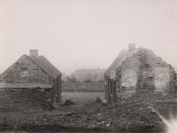
Place Picture Notes
The pit head at Boldon. The lines in the foreground are a part of the the Tyne Dock to Consett route. The pit was sunk in 1869 and was closed in 1982. It was a lucky pit in that there were no major incidents during its lifetime, although, inevitably enough, it claimed the lives of a number of miners.
South End of Colliery, Boldon, Co Durham is located at latitude 54.953963, longitude -1.455002.
Brandon and Byshottles, Co Durham
Brandon and Byshottles, Co Durham is located at latitude 54.736614, longitude -1.656704.
Auton Stile, Broompark, Co Durham
Auton Stile, Broompark, Co Durham is located at latitude 54.783056, longitude -1.632457.
Broompark, Co Durham
Broompark, Co Durham is located at latitude 54.770098, longitude -1.621256.
Cross Row, Broomside, Co Durham
Cross Row, Broomside, Co Durham is located at latitude 54.789898, longitude -1.52195.
Place Notes
Broomside
Church Row (no 18), Burnhope, Co Durham
Church Row (no 18), Burnhope, Co Durham is located at latitude 54.832091, longitude -1.699968.
Castle Eden, Co Durham
Castle Eden, Co Durham is located at latitude 54.737308, longitude -1.336212.
Castleside, Co Durham
Castleside, Co Durham is located at latitude 54.833671, longitude -1.880572.
Catchgate, Co Durham
Catchgate, Co Durham is located at latitude 54.860752, longitude -1.74777.
Chester Le St, Co Durham
Chester Le St, Co Durham is located at latitude 54.85969, longitude -1.574264.
Place References (21)
Parent Place: Co Durham
1827 Individual: Robert Knowles (b. 1827 )
1828 Individual: Jane Pickering (b. 1828 )
1831 Individual: Margaret Knowles (b. 1831 )
1833 Individual: William Knowles (b. 1833 )
1837 Individual: Thomas Knowles (b. 1837 )
1841 Occupancy/Contact: Peter Knowles , Archibald Knowles , William Knowles , Thomas Knowles , Margaret Knowles , Ann Knowles , Robert Knowles , Archibald Knowles , Ann Hope (1841 - 1841)
1849 Occupancy/Contact: Robert Knowles , Jane Pickering (1849 - 1849)
1851 Occupancy/Contact: Robert Knowles , Jane Pickering (1851 - 1851)
1851 Occupancy/Contact: William Knowles , Thomas Knowles , Margaret Knowles , Archibald Knowles , Ann Hope (1851 - 1851)
1856 Individual: Jane Knowles (b. 1856 )
1858 Individual: Sarah Knowles (b. 1858 )
1860 Individual: Ann Knowles (b. 1860 )
1861 Occupancy/Contact: Sarah Knowles , Archibald Knowles , Ann Knowles , Jane Knowles , Robert Knowles , Jane Pickering (1861 - 1861)
1861 Occupancy/Contact: William Knowles , Archibald Knowles , Ann Hope (1861 - 1861)
1861 Individual: William Knowles (b. 1861 )
1863 Individual: Barbara Knowles (b. 1863 )
1864 Individual: Robert Knowles (b. 1864 )
1865 Individual: Archibald Knowles (d. 1865 )
1866 Individual: Margaret Knowles (b. 1866 )
1894 Individual: Henderson Bell (d. 1894 )
Hunnam's Yard, Chester Le St, Co Durham
Hunnam's Yard, Chester Le St, Co Durham is located at latitude 54.85969, longitude -1.574264.
Union Lane, Chester Moor, Co Durham
Union Lane, Chester Moor, Co Durham is located at latitude 54.836686, longitude -1.584864.
Belle Vue Terrace (no 16), Consett, Co Durham
Belle Vue Terrace (no 16), Consett, Co Durham is located at latitude 54.860999, longitude -1.842098.
Consett, Co Durham
Consett, Co Durham is located at latitude 54.860826, longitude -1.842356.
Cornsay, Co Durham
Cornsay, Co Durham is located at latitude 54.78683, longitude -1.776352.
Liddel Street (no 61), Cornsay Colliery, Co Durham
Liddel Street (no 61), Cornsay Colliery, Co Durham is located at latitude 54.785765, longitude -1.736526.
Coxhoe, Co Durham
Coxhoe, Co Durham is located at latitude 54.714929, longitude -1.502552.
Smokey Row (no 24), Coxhoe, Co Durham
Smokey Row (no 24), Coxhoe, Co Durham is located at latitude 54.714929, longitude -1.502552.
Davy Lamp, Co Durham
Davy Lamp, Co Durham is located at latitude 54.721126, longitude -1.470323.
Deaf Hill, Co Durham
Deaf Hill, Co Durham is located at latitude 54.720208, longitude -1.405563.
Church Street, Durham, Co Durham
Church Street, Durham, Co Durham is located at latitude 54.771138, longitude -1.572247.
Clay Path (no 29), Durham, Co Durham
Clay Path (no 29), Durham, Co Durham is located at latitude 54.778267, longitude -1.572676.
Durham, Co Durham
Durham, Co Durham is located at latitude 54.778514, longitude -1.560402.
Place References (18)
Parent Place: Co Durham
Place: Wear House, Elvet Waterside, Durham, Co Durham
Place: South Street, Durham, Co Durham
Place: Clay Path (no 29), Durham, Co Durham
Place: Church Street, Durham, Co Durham
Place: Elvet Prison, Durham, Co Durham
1796 Individual: Jane Henderson (b. Jul 4th, 1796 )
1828 Individual: William S Hay (b. 1828 )
1888 Individual: Samuel Littlewood (d. 1888 )
1890 Individual: Albert Aberdeen (b. 1890 )
1894 Individual: Margaret Ann Henderson (d. 1894 )
1920 Individual: Ruby I Littlewood (b. 1920 )
1922 Individual: Jennie Littlewood (b. Jan 16th, 1922 )
1932 Individual: Cecilia Hannah Littlewood (b. Apr 15th, 1932 d. 2005 )
1941 Individual: Henderson Bell Littlewood (d. 1941 )
1966 Individual: Helena Maud Raine (d. 1966 )
1976 Individual: Thomas Harper (d. 1976 )
2005 Individual: Henderson Bell Littlewood (d. Aug 2005 )
Elvet Prison, Durham, Co Durham
Elvet Prison, Durham, Co Durham is located at latitude 54.773344, longitude -1.568052.
South Street, Durham, Co Durham
South Street, Durham, Co Durham is located at latitude 54.774678, longitude -1.580315.
Wear House, Elvet Waterside, Durham, Co Durham
Wear House, Elvet Waterside, Durham, Co Durham is located at latitude 54.77641, longitude -1.570745.
Easington, Co Durham
Easington, Co Durham is located at latitude 54.784677, longitude -1.356554.
East Hetton, Co Durham
East Hetton, Co Durham is located at latitude 54.821447, longitude -1.452341.
Place References (10)
Parent Place: Co Durham
Place: New Low Row (no 13), East Hetton, Co Durham
Place: New Low Row (no 27), East Hetton, Co Durham
Place: Main Street (no 57), East Hetton, Co Durham
Place: Low Plantation Row (no 11), East Hetton, Co Durham
Place: New Low Row (no 2), East Hetton, Co Durham
Place: New Row, East Hetton, Co Durham
Place: New Low Row (no 31), East Hetton, Co Durham
Place: New Low Row (no 28), East Hetton, Co Durham
Place: New Low Row (no 12), East Hetton, Co Durham
Low Plantation Row (no 11), East Hetton, Co Durham
Low Plantation Row (no 11), East Hetton, Co Durham is located at latitude 54.717407, longitude -1.46955.
Main Street (no 57), East Hetton, Co Durham
Main Street (no 57), East Hetton, Co Durham is located at latitude 54.726667, longitude -1.463611.
New Low Row (no 12), East Hetton, Co Durham
New Low Row (no 12), East Hetton, Co Durham is located at latitude 54.726667, longitude -1.463611.
New Low Row (no 13), East Hetton, Co Durham
New Low Row (no 13), East Hetton, Co Durham is located at latitude 54.726667, longitude -1.463611.
New Low Row (no 2), East Hetton, Co Durham
New Low Row (no 2), East Hetton, Co Durham is located at latitude 54.726667, longitude -1.463611.
New Low Row (no 27), East Hetton, Co Durham
New Low Row (no 27), East Hetton, Co Durham is located at latitude 54.726667, longitude -1.463611.
New Low Row (no 28), East Hetton, Co Durham
New Low Row (no 28), East Hetton, Co Durham is located at latitude 54.726667, longitude -1.463611.
Place References (2)
Parent Place: East Hetton, Co Durham
1891 Occupancy/Contact: William Coates Henderson , Jane Ann Gibbon , John S Henderson , Margaret Ann Henderson , George William Henderson , Jane Henderson , Hannah Henderson , James Henderson , Sophia Henderson , Mary Elizabeth Henderson (1891 - 1891)
New Low Row (no 31), East Hetton, Co Durham
New Low Row (no 31), East Hetton, Co Durham is located at latitude 54.726667, longitude -1.463611.
New Row, East Hetton, Co Durham
New Row, East Hetton, Co Durham is located at latitude 54.726667, longitude -1.463611.
Albert Terrace (no 37), Esh Winning, Co Durham
Albert Terrace (no 37), Esh Winning, Co Durham is located at latitude 54.771311, longitude -1.701808.
Place Notes
Esh Winning has seen the growth of new housing estates in recent years but much of the older colliery village has gone.
Esh Winning, Co Durham
Esh Winning, Co Durham is located at latitude 54.7699, longitude -1.704254.
Place Notes
Esh Winning has seen the growth of new housing estates in recent years but much of the older colliery village has gone.
North Street (no 34), Esh Winning, Co Durham
North Street (no 34), Esh Winning, Co Durham is located at latitude 54.777512, longitude -1.699469.
Place Notes
This street no longer exists
Garmondsway, Co Durham
Garmondsway, Co Durham is located at latitude 54.696803, longitude -1.488991.
Garmondsway Moor, Co Durham
Garmondsway Moor, Co Durham is located at latitude 54.696803, longitude -1.488991.
Blue Quarries Road, Gateshead, Co Durham
Blue Quarries Road, Gateshead, Co Durham is located at latitude 54.94108, longitude -1.584036.
Place Notes
The original cottages were demolished in 1938. The name Blue Quarries was derived from the ‘blur’ colour of the stone quarried nearby.
Place References (3)
Parent Place: Gateshead, Co Durham
1891 Occupancy/Contact: Thomas William Farrer , Mary Helen Farrer , Isabella M Farrer , John E Farrer , Annie Farrer , John Farrer , Ann Waugh (1891 - 1891)
1901 Occupancy/Contact: Isabella M Farrer , John E Farrer , John Farrer , Ann Waugh (1901 - 1901)
Gateshead, Co Durham
Gateshead, Co Durham is located at latitude 54.959458, longitude -1.601858.
High Fell, Gateshead, Co Durham
High Fell, Gateshead, Co Durham is located at latitude 54.9340, longitude -1.5850.
Sodhouse Bank (106), Gateshead, Co Durham
Sodhouse Bank (106), Gateshead, Co Durham is located at latitude 54.934835, longitude -1.598082.
Place Notes
LOW FELL
Gorecock, Greencroft, Co Durham
Gorecock, Greencroft, Co Durham is located at latitude 54.851476, longitude -1.755066.
Greencroft Cottages, Greencroft, Co Durham
Greencroft Cottages, Greencroft, Co Durham is located at latitude 54.84454, longitude -1.738897.
Greencroft, Co Durham
Greencroft, Co Durham is located at latitude 54.84454, longitude -1.738897.
Place References (6)
Parent Place: Co Durham
Place: Gorecock, Greencroft, Co Durham
Place: Greencroft Cottages, Greencroft, Co Durham
1872 Occupancy/Contact: Henderson Bell (1872 - 1872)
1873 Individual: Mary Hannah Bell (b. Sep 11th, 1873 )
1881 Occupancy/Contact: Simon Littlewood , John Littlewood , Charles Littlewood , Samuel Littlewood , Frances Riseborough , Julia Littlewood (1881 - 1881)
Grindon, Co Durham
Grindon, Co Durham is located at latitude 54.619397, longitude -1.354316.
Hartlepool, Co Durham
Hartlepool, Co Durham is located at latitude 54.682565, longitude -1.216779.
Haswell, Co Durham
Haswell, Co Durham is located at latitude 54.782771, longitude -1.417408.
Hilton, Co Durham
Hilton, Co Durham is located at latitude 54.592555, longitude -1.746483.
Houghton, Co Durham
Houghton, Co Durham is located at latitude 54.843433, longitude -1.468091.
Houghton Le Spring, Co Durham
Houghton Le Spring, Co Durham is located at latitude 54.843433, longitude -1.468091.
Kelloe, Co Durham
Kelloe, Co Durham is located at latitude 54.721113, longitude -1.470728.
Lancaster Street (no 16), Murton Colliery, Co Durham
Lancaster Street (no 16), Murton Colliery, Co Durham is located at latitude 54.819926, longitude -1.387453.
Lanchester, Co Durham
Lanchester, Co Durham is located at latitude 54.820717, longitude -1.740732.
Parish Church, Lanchester, Co Durham
Parish Church, Lanchester, Co Durham is located at latitude 54.821138, longitude -1.740711.
North Street, Langley Park, Co Durham
North Street, Langley Park, Co Durham is located at latitude 54.798681, longitude -1.67078.
Leamside, Co Durham
Leamside, Co Durham is located at latitude 54.814456, longitude -1.517161.
Pit House Lane, Leamside, Co Durham
Pit House Lane, Leamside, Co Durham is located at latitude 54.81804, longitude -1.517552.
Little Town, Co Durham
Little Town, Co Durham is located at latitude 54.784132, longitude -1.473584.
Hill House, Middleton, Teesdale, Co Durham
Hill House, Middleton, Teesdale, Co Durham is located at latitude 54.623078, longitude -2.077832.
Hood Street, Middleton, Teesdale, Co Durham
Hood Street, Middleton, Teesdale, Co Durham is located at latitude 54.623078, longitude -2.077832.
Hude, Middleton, Teesdale, Co Durham
Hude, Middleton, Teesdale, Co Durham is located at latitude 54.626928, longitude -2.086759.
Place References (4)
Parent Place: Middleton, Teesdale, Co Durham
1840 Occupancy/Contact: John Raine , Thomas Raine , Jane Wearmouth (1840 - 1840)
1841 Occupancy/Contact: John Raine , Thomas Raine , Jane Wearmouth (1841 - 1841)
1851 Occupancy/Contact: John Raine , Thomas Raine , Jane Wearmouth , Thomas Raine , Mary Jane Raine , Philip Raine , Charles Raine (1851 - 1851)
Low Houses, Middleton, Teesdale, Co Durham
Low Houses, Middleton, Teesdale, Co Durham is located at latitude 54.623078, longitude -2.077832.
Middleton, Teesdale, Co Durham
Middleton, Teesdale, Co Durham is located at latitude 54.622978, longitude -2.077789.
Place References (30)
Parent Place: Co Durham
Place: Hude, Middleton, Teesdale, Co Durham
Place: Town End, Middleton, Teesdale, Co Durham
Place: Hood Street, Middleton, Teesdale, Co Durham
Place: Low Houses, Middleton, Teesdale, Co Durham
Place: Hill House, Middleton, Teesdale, Co Durham
1792 Individual: Elizabeth Watson (b. 1792 bpt. Apr 15th, 1792 )
1793 Marriage / Union: Joseph Wearmouth & Phebe Spence (m. Oct 19th, 1793 )
1794 Individual: John Wearmouth (b. 1794 bpt. Nov 22nd, 1794 )
1814 Individual: Margaret Raine (b. 1814 bpt. Aug 28th, 1814 )
1817 Individual: Thomas Raine (b. 1817 bpt. Aug 31st, 1817 )
1818 Individual: Mary Raine (b. 1818 bpt. Jun 19th, 1818 )
1820 Individual: Mary Raine (b. 1820 bpt. Apr 23rd, 1820 d. Jul 12th, 1822 )
1823 Occupancy/Contact: John Wearmouth (1823 - 1823)
1823 Individual: Jane Wearmouth (b. 1823 )
1823 Individual: Thomas Wearmouth (b. 1823 bpt. Jul 23rd, 1823 )
1823 Individual: William Raine (b. 1823 bpt. Jul 13th, 1823 )
1823 Marriage / Union: John Wearmouth & Elizabeth Watson (m. Jan 24th, 1823 )
1826 Occupancy/Contact: John Wearmouth (1826 - 1826)
1826 Individual: Mary Raine (b. 1826 bpt. May 21st, 1826 )
1829 Individual: Ann Raine (b. 1829 bpt. May 31st, 1829 )
1840 Marriage / Union: Thomas Raine & Jane Wearmouth (m. Jun 6th, 1840 )
1840 Individual: John Raine (b. Nov 13th, 1840 )
1841 Occupancy/Contact: John Raine , Mary Bainbridge , William Raine , Ann Raine , Margaret Gibson (1841 - 1841)
1843 Individual: Thomas Raine (b. 1843 )
1845 Individual: Charles Raine (b. 1845 )
1847 Individual: Philip Raine (b. 1847 )
1849 Individual: Mary Jane Raine (b. 1849 )
1858 Individual: Matthew Raine (b. 1858 )
1860 Individual: James Raine (b. 1860 )
Town End, Middleton, Teesdale, Co Durham
Town End, Middleton, Teesdale, Co Durham is located at latitude 54.623078, longitude -2.077832.
Moorsley, Co Durham
Moorsley, Co Durham is located at latitude 54.808402, longitude -1.472383.
Green Street (no 45), Murton Colliery, Co Durham
Green Street (no 45), Murton Colliery, Co Durham is located at latitude 54.815067, longitude -1.37975.
Place Notes
This street no longer exists
New Stanley, Co Durham
New Stanley, Co Durham is located at latitude 54.872656, longitude -1.696229.
Newcastle Upon Tyne, Co Durham
Newcastle Upon Tyne, Co Durham is located at latitude 54.977614, longitude -1.612587.
Old Trindon, Co Durham
Old Trindon, Co Durham is located at latitude 54.704094, longitude -1.427879.
Lambton Main Engine, Pittington, Co Durham
Lambton Main Engine, Pittington, Co Durham is located at latitude 54.791791, longitude -1.477194.
Londonderry Row, Pittington, Co Durham
Londonderry Row, Pittington, Co Durham is located at latitude 54.793365, longitude -1.489205.
Place Notes
At Pittington, the family of the Marquis of Londonderry owned the collieries.
Pittington, Co Durham
Pittington, Co Durham is located at latitude 54.793906, longitude -1.490793.
Dyke Row (no 19), Quebec, Co Durham
Dyke Row (no 19), Quebec, Co Durham is located at latitude 54.787844, longitude -1.721206.
Quebec, Co Durham
Quebec, Co Durham is located at latitude 54.787844, longitude -1.721206.
Rainton, Co Durham
Rainton, Co Durham is located at latitude 54.818838, longitude -1.487961.
Blandford Place (no 2), Seaham Harbour, Co Durham
Blandford Place (no 2), Seaham Harbour, Co Durham is located at latitude 54.837632, longitude -1.336234.
Brick Yard, Seaham Harbour, Co Durham
Brick Yard, Seaham Harbour, Co Durham is located at latitude 54.838318, longitude -1.336513.
Henry Street (no 33), Seaham Harbour, Co Durham
Henry Street (no 33), Seaham Harbour, Co Durham is located at latitude 54.838762, longitude -1.335182.
Henry Street, Seaham Harbour, Co Durham
Henry Street, Seaham Harbour, Co Durham is located at latitude 54.838762, longitude -1.335182.
Place References (4)
Parent Place: Seaham Harbour, Co Durham
1841 Occupancy/Contact: Frederick Quilter , Martha I Quilter , Frederick Quilter , Isabella Hunter (1841 - 1841)
1851 Occupancy/Contact: Frederick Quilter , Matilda Quilter , Martha I Quilter , Mary Ann Quilter , Frederick Quilter , Isabella Hunter (1851 - 1851)
1861 Occupancy/Contact: Hannah Jane Ford , Margaret Hunter , William S Hay , Mary A Hay , Robert W Hay , Margaret J Hay , Ellen Hay (1861 - 1861)
Seaham Harbour, Co Durham
Seaham Harbour, Co Durham is located at latitude 54.838318, longitude -1.336513.
Place References (22)
Parent Place: Co Durham
Place: Henry Street, Seaham Harbour, Co Durham
Place: Henry Street (no 33), Seaham Harbour, Co Durham
Place: Brick Yard, Seaham Harbour, Co Durham
Place: Blandford Place (no 2), Seaham Harbour, Co Durham
1835 Individual: Margaret Hunter (b. 1835 )
1840 Individual: Frederick Quilter (b. 1840 )
1841 Individual: Martha I Quilter (b. 1841 )
1843 Individual: Matilda Quilter (b. 1843 )
1844 Individual: Robert Quilter (b. 1844 )
1848 Individual: Mary Ann Quilter (b. 1848 )
1854 Individual: Isabella Quilter (b. 1854 )
1854 Individual: Sarah Hunter (b. 1854 )
1856 Individual: Robert W Hay (b. 1856 )
1857 Individual: Margaret J Hay (b. 1857 )
1860 Individual: Ellen Hay (b. 1860 )
1860 Individual: Alexander Hunter (b. 1860 )
1863 Individual: Mary Hunter (b. 1863 )
1865 Occupancy/Contact: John Raine , Mary Ann Quilter , Frederick Quilter , Thomas Raine (1865 - 1865)
1865 Individual: Robert Hunter (b. 1865 )
1867 Individual: Mary Ann Hunter (d. Sep 24th, 1867 )
1870 Individual: Samuel Hunter (b. 1870 )
Sedgefield, Co Durham
Sedgefield, Co Durham is located at latitude 54.653453, longitude -1.448908.
1st Cross Row, Shadforth, Co Durham
1st Cross Row, Shadforth, Co Durham is located at latitude 54.762697, longitude -1.467267.
Shadforth, Co Durham
Shadforth, Co Durham is located at latitude 54.762697, longitude -1.467267.
Shield Row, Co Durham
Shield Row, Co Durham is located at latitude 54.878162, longitude -1.691294.
Sheriff Hill, Co Durham
Sheriff Hill, Co Durham is located at latitude 54.945016, longitude -1.587954.
Shotton, Co Durham
Shotton, Co Durham is located at latitude 54.76324, longitude -1.387582.
Queen Street (no 4), Shotton Colliery, Co Durham
Queen Street (no 4), Shotton Colliery, Co Durham is located at latitude 54.762274, longitude -1.384792.
School Row (no 10), Shotton Colliery, Co Durham
School Row (no 10), Shotton Colliery, Co Durham is located at latitude 54.76324, longitude -1.387582.
Hepworth Street (no 23), Sleetburn, Co Durham
Hepworth Street (no 23), Sleetburn, Co Durham is located at latitude 54.770333, longitude -1.649242.
Place Notes
Now known as New Brancepeth
Sleetburn, Co Durham
Sleetburn, Co Durham is located at latitude 54.76834, longitude -1.652799.
Place Notes
Now known as New Brancepeth
South Hetton, Co Durham
South Hetton, Co Durham is located at latitude 54.803505, longitude -1.423073.
Stanhope, Co Durham
Stanhope, Co Durham is located at latitude 54.747266, longitude -2.006807.
Middle Street (no 47), Sunderland, Co Durham
Middle Street (no 47), Sunderland, Co Durham is located at latitude 54.906916, longitude -1.384792.
Sunderland, Co Durham
Sunderland, Co Durham is located at latitude 54.904449, longitude -1.381453.
Lintz Colliery, Tanfield, Co Durham
Lintz Colliery, Tanfield, Co Durham is located at latitude 54.899167, longitude -1.753611.
Tanfield, Co Durham
Tanfield, Co Durham is located at latitude 54.893986, longitude -1.707942.
William St (no 21), Tanfield, Co Durham
William St (no 21), Tanfield, Co Durham is located at latitude 54.893986, longitude -1.707942.
Tantobie, Co Durham
Tantobie, Co Durham is located at latitude 54.885034, longitude -1.728631.
Teesdale , Co Durham
Teesdale , Co Durham is located at latitude 54.622978, longitude -2.077789.
Pit Street (no 16), Thornley, Co Durham
Pit Street (no 16), Thornley, Co Durham is located at latitude 54.750263, longitude -1.429811.
Place Notes
This street no longer exists
Tow Law, Co Durham
Tow Law, Co Durham is located at latitude 54.749, longitude -1.815233.
Trimdon, Co Durham
Trimdon, Co Durham is located at latitude 54.704094, longitude -1.427879.
Place References (19)
Parent Place: Co Durham
1799 Individual: Jane Sanderson (b. May 7th, 1799 )
1821 Marriage / Union: James Henderson & Jane Sanderson (m. Jun 11th, 1821 )
1824 Individual: John Henderson (b. 1824 )
1827 Individual: William Henderson (b. 1827 )
1833 Individual: Matthew Henderson (b. 1833 )
1841 Occupancy/Contact: John Henderson , Matthew Henderson , William Henderson , James Henderson , James Henderson , Jane Sanderson (1841 - 1841)
1841 Occupancy/Contact: James Sanderson , Jane Coates (1841 - 1841)
1843 Individual: Sanderson Henderson (b. 1843 )
1847 Occupancy/Contact: James Henderson , Margaret Moor , William Coates Henderson (1847 - 1847)
1847 Individual: William Coates Henderson (b. Apr 5th, 1847 )
1848 Individual: Mathew Henderson (b. 1848 )
1850 Individual: John Sanderson Henderson (b. 1850 )
1851 Occupancy/Contact: John Henderson , Matthew Henderson , Sanderson Henderson , James Henderson , Jane Sanderson (1851 - 1851)
1852 Individual: Mary Jane Henderson (b. 1852 )
1861 Occupancy/Contact: James Henderson , Jane Sanderson (1861 - 1861)
1866 Individual: John Chaytor (b. 1866 )
1868 Individual: Thomas James (b. 1868 )
1871 Occupancy/Contact: James Henderson (1871 - 1871)
Upper Hogg Street, Trimdon Grange, Co Durham
Upper Hogg Street, Trimdon Grange, Co Durham is located at latitude 54.716143, longitude -1.409941.
Waskerley, Co Durham
Waskerley, Co Durham is located at latitude 54.806621, longitude -1.930847.
College View (no 20), Waterhouses, Co Durham
College View (no 20), Waterhouses, Co Durham is located at latitude 54.766816, longitude -1.709852.
Lymington Terrace (no 39), Waterhouses, Co Durham
Lymington Terrace (no 39), Waterhouses, Co Durham is located at latitude 54.768402, longitude -1.700494.
Place Notes
Esh Winning has seen the growth of new housing estates in recent years but much of the older colliery village has gone.
Place References (5)
Parent Place: Waterhouses, Co Durham
1897 Occupancy/Contact: Henderson Bell Littlewood , Simon Littlewood , Mary Hannah Bell (1897 - 1897)
1897 Individual: Henderson Bell Littlewood (b. Aug 23rd, 1897 )
1901 Occupancy/Contact: Henderson Bell Littlewood , Simon Wilfred Littlewood , Simon Littlewood , Mary Hannah Bell , Albert H Littlewood (1901 - 1901)
1911 Occupancy/Contact: Henderson Bell Littlewood , Simon Wilfred Littlewood , Simon Littlewood , Mary Hannah Bell , Albert H Littlewood , Alfred John Littlewood , Jennie Littlewood (1911 - 1911)
Lymington Terrace, Waterhouses, Co Durham
Lymington Terrace, Waterhouses, Co Durham is located at latitude 54.768402, longitude -1.700494.
Place Notes
Esh Winning has seen the growth of new housing estates in recent years but much of the older colliery village has gone.
Waterhouses, Co Durham
Waterhouses, Co Durham is located at latitude 54.765765, longitude -1.72524.
Front Row (no 134), Freehold Field, West Rainton, Co Durham
Front Row (no 134), Freehold Field, West Rainton, Co Durham is located at latitude 54.811011, longitude -1.508002.
Place Notes
This street no longer exists
Grainger's Terrace (no 27), West Rainton , Co Durham
Grainger's Terrace (no 27), West Rainton , Co Durham is located at latitude 54.819765, longitude -1.526949.
Place Notes
This street no longer exists
Grainger's Terrace (no 30), West Rainton, Co Durham
Grainger's Terrace (no 30), West Rainton, Co Durham is located at latitude 54.819765, longitude -1.526949.
Place Notes
This street no longer exists
West Rainton, Co Durham
West Rainton, Co Durham is located at latitude 54.816297, longitude -1.498195.
Elizabeth St (no 25), Wheatley Hill, Co Durham
Elizabeth St (no 25), Wheatley Hill, Co Durham is located at latitude 54.74957, longitude -1.405885.
Place References (2)
Parent Place: Wheatley Hill, Co Durham
1901 Occupancy/Contact: Robert Harper , James Henry Harper , Margaret Harper , William Harper , John Harper , Joseph Harper , Ezekiel Harper , Mary Knowles , Elizabeth Jane Harper , Barbara Harper , Mary Ann Harper (1901 - 1901)
Emily Street (no 18), Wheatley Hill, Co Durham
Emily Street (no 18), Wheatley Hill, Co Durham is located at latitude 54.74957, longitude -1.405885.
Grainger Street (no 24), Wheatley Hill, Co Durham
Grainger Street (no 24), Wheatley Hill, Co Durham is located at latitude 54.74957, longitude -1.405885.
John Street (no 6), Wheatley Hill, Co Durham
John Street (no 6), Wheatley Hill, Co Durham is located at latitude 54.749421, longitude -1.406969.
Place Notes
This street no longer exists.
Sunderland Street (no 13), Wheatley Hill, Co Durham
Sunderland Street (no 13), Wheatley Hill, Co Durham is located at latitude 54.74957, longitude -1.405885.
Place References (3)
Parent Place: Wheatley Hill, Co Durham
1911 Occupancy/Contact: Robert Harper , James Henry Harper , Margaret Harper , William Harper , John Harper , Joseph Harper , Ezekiel Harper , Mary Knowles , Emma Harper , Sarah Harper , Annie Harper , Alice Harper (1911 - 1911)
1915 Occupancy/Contact: Robert Harper (1915 - 1915)
Sunderland Street (no 5), Wheatley Hill, Co Durham
Sunderland Street (no 5), Wheatley Hill, Co Durham is located at latitude 54.74957, longitude -1.405885.
Temperance Buildings (no 1), Wheatley Hill, Co Durham
Temperance Buildings (no 1), Wheatley Hill, Co Durham is located at latitude 54.74957, longitude -1.405885.
Wheatley Hill, Co Durham
Wheatley Hill, Co Durham is located at latitude 54.74957, longitude -1.405885.
Place References (22)
Parent Place: Co Durham
Picture: picture-pic00104.htm
Place: Elizabeth St (no 25), Wheatley Hill, Co Durham
Place: Sunderland Street (no 13), Wheatley Hill, Co Durham
Place: Temperance Buildings (no 1), Wheatley Hill, Co Durham
Place: Sunderland Street (no 5), Wheatley Hill, Co Durham
Place: Grainger Street (no 24), Wheatley Hill, Co Durham
Place: John Street (no 6), Wheatley Hill, Co Durham
Place: Emily Street (no 18), Wheatley Hill, Co Durham
1894 Individual: Robert Harper (b. 1894 )
1896 Individual: William Harper (b. 1896 )
1896 Individual: James Harper (b. 1896 )
1898 Individual: John Harper (b. 1898 )
1898 Individual: Henry Harper (b. 1898 )
1899 Individual: Joseph Harper (b. 1899 )
1900 Individual: Mary E Harper (b. 1900 )
1902 Individual: Sarah Harper (b. 1902 )
1903 Individual: Emma Harper (b. 1903 )
1906 Individual: Annie Harper (b. 1906 )
1910 Individual: Alice Harper (b. 1910 )
1927 Individual: Joseph Harper (d. Apr 22nd, 1927 )
1961 Individual: John Edward Venables (d. 1961 )
Wingate, Co Durham
Wingate, Co Durham is located at latitude 54.73483, longitude -1.380157.
Winlaton, Co Durham
Winlaton, Co Durham is located at latitude 54.953298, longitude -1.72833.
Witton Gilbert, Co Durham
Witton Gilbert, Co Durham is located at latitude 54.805731, longitude -1.638165.
Wolsingham, Co Durham
Wolsingham, Co Durham is located at latitude 54.732104, longitude -1.882439.
Co Durham
Co Durham is located at latitude 54.586525, longitude -1.89997.
Place References (94)
Parent Place: United Kingdom
Place: Easington, Co Durham
Place: Durham, Co Durham
Place: Waterhouses, Co Durham
Place: Shotton, Co Durham
Place: Wheatley Hill, Co Durham
Place: Esh Winning, Co Durham
Place: Kelloe, Co Durham
Place: East Hetton, Co Durham
Place: Trimdon, Co Durham
Place: Middleton, Teesdale, Co Durham
Place: Bishop Middleham, Co Durham
Place: Sedgefield, Co Durham
Place: Leamside, Co Durham
Place: West Rainton, Co Durham
Place: North Street, Langley Park, Co Durham
Place: Shadforth, Co Durham
Place: Sunderland, Co Durham
Place: Broompark, Co Durham
Place: Pittington, Co Durham
Place: Consett, Co Durham
Place: Tanfield, Co Durham
Place: Shield Row, Co Durham
Place: Pit Street (no 16), Thornley, Co Durham
Place: Seaham Harbour, Co Durham
Place: Fleet Street (no 11), Bishop Wearmouth, Co Durham
Place: Hartlepool, Co Durham
Place: Houghton, Co Durham
Place: Lanchester, Co Durham
Place: Moorsley, Co Durham
Place: Little Town, Co Durham
Place: Hilton, Co Durham
Place: Brandon and Byshottles, Co Durham
Place: Rainton, Co Durham
Place: Chester Le St, Co Durham
Place: South Hetton, Co Durham
Place: Green Street (no 45), Murton Colliery, Co Durham
Place: Gateshead, Co Durham
Place: Sheriff Hill, Co Durham
Place: South End of Colliery, Boldon, Co Durham
Place: Castle Eden, Co Durham
Place: Garmondsway Moor, Co Durham
Place: Garmondsway, Co Durham
Place: Greencroft, Co Durham
Place: Cornsay, Co Durham
Place: Sleetburn, Co Durham
Place: Union Lane, Chester Moor, Co Durham
Place: Tantobie, Co Durham
Place: Newcastle Upon Tyne, Co Durham
Place: Wolsingham, Co Durham
Place: Winlaton, Co Durham
Place: Hunnam's Yard, Chester Le St, Co Durham
Place: Old Trindon, Co Durham
Place: Grindon, Co Durham
Place: The Chapel Of The Secular Clergy And The Jesuits, Co Durham
Place: Castleside, Co Durham
Place: New Stanley, Co Durham
Place: Church Row (no 18), Burnhope, Co Durham
Place: Teesdale , Co Durham
Place: Haswell, Co Durham
Place: Houghton Le Spring, Co Durham
Place: Davy Lamp, Co Durham
Place: Stanhope, Co Durham
Place: Witton Gilbert, Co Durham
Place: Quebec, Co Durham
Place: Catchgate, Co Durham
Place: Waskerley, Co Durham
Place: Wingate, Co Durham
Place: Upper Hogg Street, Trimdon Grange, Co Durham
Place: Tow Law, Co Durham
Place: Deaf Hill, Co Durham
Place: Bishop Auckland, Co Durham
Place: Coxhoe, Co Durham
Place: Thornley, Co Durham
1751 Individual: James Sanderson (b. 1751 )
1758 Individual: Margaret Gibson (b. 1758 )
1761 Individual: Jane Coates (b. 1761 )
1787 Individual: Mary Bainbridge (b. 1787 )
1814 Individual: Barbara Knowles (b. 1814 )
1815 Individual: Archibald Knowles (b. 1815 )
1817 Individual: Mary Knowles (b. 1817 )
1821 Individual: Peter Knowles (b. 1821 )
1822 Individual: Jane Knowles (b. 1822 )
1828 Individual: Alexander Ford Hunter (b. 1828 )
1834 Individual: Ann Knowles (b. 1834 )
1859 Individual: Cuthbert Robson (b. 1859 )
1879 Individual: Mary Ann Harper (b. 1879 )
1886 Individual: James Routledge (b. 1886 )
1905 Individual: Joseph Littlewood (d. 1905 )
1912 Individual: William Lincoln (b. 1912 )
1914 Individual: May Lincoln (b. 1914 )
1917 Individual: James Lincoln (b. 1917 )
1945 Individual: Ezekiel Harper (d. 1945 )
2001 Individual: Margaret A Harper (d. Jan 2001 )
Quarry Street (no 89), Thornley, Co Durham
Quarry Street (no 89), Thornley, Co Durham is located at latitude 54.730983, longitude -1.823496.
The Chapel Of The Secular Clergy And The Jesuits, Co Durham
The Chapel Of The Secular Clergy And The Jesuits, Co Durham is located at latitude 54.586525, longitude -1.89997.
Thornley, Co Durham
Thornley, Co Durham is located at latitude 54.730983, longitude -1.823496.
Truro, Cornwall
Truro, Cornwall is located at latitude 50.262927, longitude -5.050664.
Cornwall
Cornwall is located at latitude 50.336696, longitude -5.020752.
Brampton, Cumberland
Brampton, Cumberland is located at latitude 54.942083, longitude -2.737999.
Culgaith, Cumberland
Culgaith, Cumberland is located at latitude 54.660727, longitude -2.60479.
Lanercost, Cumberland
Lanercost, Cumberland is located at latitude 54.966726, longitude -2.698088.
Place References (25)
Parent Place: Cumberland
1683 Individual: James Barnfather (b. 1683 d. Mar 11th, 1757 )
1686 Individual: Jane Urwin (b. 1686 )
1714 Individual: Mary Tallantyre (b. 1714 )
1716 Individual: Margaret Armstrong (b. Jul 4th, 1716 d. Dec 4th, 1751 )
1717 Individual: William Barnfather (b. Jan 18th, 1717 )
1718 Individual: James Rowntree (b. May 21st, 1718 )
1743 Individual: James Rowntree (b. 1743 )
1744 Individual: Mary Rowntree (b. 1744 )
1744 Marriage / Union: William Barnfather & Mary Tallantyre (m. May 6th, 1744 )
1745 Individual: John Barnfather (b. 1745 chr. Feb 17th, 1745 )
1745 Individual: Isabel Rowntree (b. 1745 )
1747 Individual: Anne Barnfather (b. 1747 bpt. Jan 11th, 1747 )
1747 Individual: John Rowntree (b. 1747 )
1749 Individual: Jane Rowntree (b. 1749 bpt. Jul 26th, 1749 d. Jul 22nd, 1833 )
1750 Individual: Sarah Barnfather (b. 1750 bpt. Dec 16th, 1750 )
1752 Individual: William Barnfather (b. 1752 bpt. Dec 7th, 1752 )
1769 Marriage / Union: John Barnfather & Jane Rowntree (m. Jun 1st, 1769 )
1774 Individual: John Barnfather (b. 1774 bpt. Jul 28th, 1774 )
1776 Individual: Betty Barnfather (b. 1776 bpt. May 4th, 1776 )
1778 Individual: Jane Barnfather (b. 1778 bpt. May 29th, 1778 )
1780 Individual: Isabel Barnfather (b. Mar 2nd, 1780 )
1782 Individual: Nancy Barnfather (b. 1782 bpt. Apr 22nd, 1785 )
1785 Individual: Sarah Barnfather (b. 1785 bpt. Apr 22nd, 1785 )
1788 Individual: Barbara Barnfather (b. 1788 bpt. Apr 23rd, 1788 )
Westward, Cumberland
Westward, Cumberland is located at latitude 54.793758, longitude -3.130417.
Cumberland
Cumberland is located at latitude 54.795935, longitude -2.785034.
Leigh, Essex
Leigh, Essex is located at latitude 51.546255, longitude 0.654244.
St Clements, Leigh, Essex
St Clements, Leigh, Essex is located at latitude 51.546255, longitude 0.654244.
Rettendon, Essex
Rettendon, Essex is located at latitude 51.655199, longitude 0.54966.
Woodham Ferrers, Essex
Woodham Ferrers, Essex is located at latitude 51.666274, longitude 0.598068.
Essex
Essex is located at latitude 51.773789, longitude 0.667419.
the region of Épehy, France (click to see modern map)
the region of Épehy, France (click to see modern map) is located at latitude 50.034402, longitude 3.117499.
Germany
Germany is located at latitude 51.165691, longitude 10.451526.
Hill, Gloucestershire
Hill, Gloucestershire is located at latitude 51.653149, longitude -2.513981.
Gloucestershire
Gloucestershire is located at latitude 51.75424, longitude -2.226105.
Five Mile Town, County Tyrone, Ireland
Five Mile Town, County Tyrone, Ireland is located at latitude 54.379883, longitude -7.313504.
Ireland
Ireland is located at latitude 53.41291, longitude -8.24389.
Manchester, Lancashire
Manchester, Lancashire is located at latitude 53.480712, longitude -2.234376.
Blackpool, Lancashire
Blackpool, Lancashire is located at latitude 53.815349, longitude -3.053598.
Lancashire
Lancashire is located at latitude 53.973051, longitude -2.624359.
Ashby de la Zouch, Leicestershire
Ashby de la Zouch, Leicestershire is located at latitude 52.74658, longitude -1.473498.
Leicestershire
Leicestershire is located at latitude 52.742943, longitude -1.141205.
Islington, London
Islington, London is located at latitude 51.534964, longitude -0.103769.
Mile End, London
Mile End, London is located at latitude 51.524178, longitude -0.03798.
London
London is located at latitude 51.500515, longitude -0.126257.
Fighting Cocks Inn, Aylsham, Norfolk
Fighting Cocks Inn, Aylsham, Norfolk is located at latitude 52.796534, longitude 1.251926.
Bedingham, Norfolk
Bedingham, Norfolk is located at latitude 52.483407, longitude 1.366768.
near St Mary Church, Burgh, Norfolk
near St Mary Church, Burgh, Norfolk is located at latitude 52.777769, longitude 1.28657.
Burgh near Aylsham, Norfolk
Burgh near Aylsham, Norfolk is located at latitude 52.779197, longitude 1.286688.
Great Plumstead, Norfolk
Great Plumstead, Norfolk is located at latitude 52.639834, longitude 1.399555.
Hempnall, Norfolk
Hempnall, Norfolk is located at latitude 52.500549, longitude 1.29776.
Henstead, Norfolk
Henstead, Norfolk is located at latitude 52.415011, longitude 1.666231.
Hethersett, Norfolk
Hethersett, Norfolk is located at latitude 52.598252, longitude 1.183777.
Little Plumstead, Norfolk
Little Plumstead, Norfolk is located at latitude 52.656915, longitude 1.419983.
Ber Street, Norwich, Norfolk
Ber Street, Norwich, Norfolk is located at latitude 52.622179, longitude 1.299454.
Norwich, Norfolk
Norwich, Norfolk is located at latitude 52.628062, longitude 1.299305.
St John de Sepulchre, Finklegate, Norwich, Norfolk
St John de Sepulchre, Finklegate, Norwich, Norfolk is located at latitude 52.621592, longitude 1.299894.
Oxnead, Norfolk
Oxnead, Norfolk is located at latitude 52.768553, longitude 1.298275.
Poringland, Norfolk
Poringland, Norfolk is located at latitude 52.565708, longitude 1.349945.
Pulham St Mary, Norfolk
Pulham St Mary, Norfolk is located at latitude 52.419958, longitude 1.253128.
Rackheath, Norfolk
Rackheath, Norfolk is located at latitude 52.674925, longitude 1.371231.
Lower Street, Salhouse, Norfolk
Lower Street, Salhouse, Norfolk is located at latitude 52.678073, longitude 1.41758.
Salhouse, Norfolk
Salhouse, Norfolk is located at latitude 52.670761, longitude 1.397324.
East Gate Green, Saxlingham, Norfolk
East Gate Green, Saxlingham, Norfolk is located at latitude 52.91532, longitude 1.011783.
Place References (4)
Parent Place: Saxlingham, Norfolk
1851 Occupancy/Contact: Kerenhappuch Adelaide Lincoln , Elizabeth Hephzibah Lincoln , William Ezekiel Lincoln , Ezra Albert Lincoln , Edgar William Lincoln , William Rufus Lincoln , William Lincoln , Hephzibah Elizabeth Everrett , Ebenezer Gilbert Lincoln , Clement Everrett Lincoln , William Ellis Lincoln (1851 - 1851)
1871 Occupancy/Contact: Kerenhappuch Adelaide Lincoln , William Lincoln , Hephzibah Elizabeth Everrett , Clement Everrett Lincoln , George Charles Reeve , Emma Reeve , Mary Ann Buck (1871 - 1871)
1871 Occupancy/Contact: Susannah Buck , William Ellis Lincoln , Ellen Lincoln , William Lincoln , Frederick Lincoln (1871 - 1871)
Saxlingham Green, Saxlingham, Norfolk
Saxlingham Green, Saxlingham, Norfolk is located at latitude 52.91532, longitude 1.011783.
Place References (5)
Parent Place: Saxlingham, Norfolk
1841 Occupancy/Contact: Elizabeth Hephzibah Lincoln , William Ezekiel Lincoln , Edgar William Lincoln , William Rufus Lincoln , William Lincoln , Hephzibah Elizabeth Everrett , William Ellis Lincoln , Isabel Lincoln , Eliza Lincoln , Agnes Lincoln (1841 - 1841)
1861 Occupancy/Contact: Kerenhappuch Adelaide Lincoln , William Rufus Lincoln , William Lincoln , Hephzibah Elizabeth Everrett , Ebenezer Gilbert Lincoln , William Ellis Lincoln (1861 - 1861)
1881 Occupancy/Contact: Elizabeth Hephzibah Lincoln , William Lincoln , Hephzibah Elizabeth Everrett (1881 - 1881)
1881 Occupancy/Contact: Susannah Buck , William Ellis Lincoln , Ellen Lincoln , William Lincoln , Frederick Lincoln , Arthur Lincoln , Emma Lincoln , Ellis Lincoln , Albert Lincoln , Laura Lincoln (1881 - 1881)
Saxlingham Street, Saxlingham, Norfolk
Saxlingham Street, Saxlingham, Norfolk is located at latitude 52.91532, longitude 1.011783.
Place References (6)
Parent Place: Saxlingham, Norfolk
1841 Occupancy/Contact: George Baldwin , Elizabeth Fulcher (1841 - 1841)
1851 Occupancy/Contact: Martha Baldwin , Frances Baldwin , Hannah Baldwin , George Baldwin , Elizabeth Fulcher , Hannah Collins (1851 - 1851)
1861 Occupancy/Contact: Martha Baldwin , George Baldwin , Elizabeth Fulcher , Margaret Baldwin (1861 - 1861)
1871 Occupancy/Contact: George Baldwin , Elizabeth Fulcher , Margaret Baldwin (1871 - 1871)
1881 Occupancy/Contact: George Baldwin , Elizabeth Fulcher , Margaret Baldwin (1881 - 1881)
Saxlingham, Norfolk
Saxlingham, Norfolk is located at latitude 52.91532, longitude 1.011783.
Shipdham, Norfolk
Shipdham, Norfolk is located at latitude 52.62827, longitude 0.892982.
Shotesham Street, Shotesham, Norfolk
Shotesham Street, Shotesham, Norfolk is located at latitude 52.54225, longitude 1.317158.
Shotesham, Norfolk
Shotesham, Norfolk is located at latitude 52.54225, longitude 1.317158.
Stoke Holy Cross, Norfolk
Stoke Holy Cross, Norfolk is located at latitude 52.568369, longitude 1.297503.
Woodton, Norfolk
Woodton, Norfolk is located at latitude 52.495559, longitude 1.376166.
Blofield Corner, Blofield, Norfolk
Blofield Corner, Blofield, Norfolk is located at latitude 52.649952, longitude 1.441396.
Blofield, Norfolk
Blofield, Norfolk is located at latitude 52.639277, longitude 1.443229.
Kiln Road, Salhouse, Norfolk
Kiln Road, Salhouse, Norfolk is located at latitude 52.670817, longitude 1.396462.
Kirby Bedon, Norfolk
Kirby Bedon, Norfolk is located at latitude 52.600769, longitude 1.368213.
Norfolk
Norfolk is located at latitude 52.614215, longitude 0.886352.
Place References (41)
Parent Place: United Kingdom
Place: Shotesham, Norfolk
Place: Poringland, Norfolk
Place: Saxlingham, Norfolk
Place: Henstead, Norfolk
Place: Hethersett, Norfolk
Place: Woodton, Norfolk
Place: Hempnall, Norfolk
Place: Bedingham, Norfolk
Place: Burgh near Aylsham, Norfolk
Place: Fighting Cocks Inn, Aylsham, Norfolk
Place: Pulham St Mary, Norfolk
Place: Salhouse, Norfolk
Place: near St Mary Church, Burgh, Norfolk
Place: Little Plumstead, Norfolk
Place: Great Plumstead, Norfolk
Place: Rackheath, Norfolk
Place: Oxnead, Norfolk
Place: Shipdham, Norfolk
Place: Norwich, Norfolk
Place: Stoke Holy Cross, Norfolk
Place: Wroxham, Norfolk
Place: Plumstead Parva, Norfolk
Place: Plumstead, Norfolk
Place: Blofield, Norfolk
Place: Kiln Road, Salhouse, Norfolk
Place: Blofield Corner, Blofield, Norfolk
Place: Kirby Bedon, Norfolk
Place: St Andrews Church, Kirby Bedon, Norfolk
1796 Individual: Elizabeth Wall (b. 1796 )
1826 Individual: Elizabeth Riseborough (b. 1826 )
1826 Individual: Samuel Riseborough (b. 1826 )
1826 Individual: Margaret Riseborough (b. 1826 )
1828 Individual: James Riseborough (b. 1828 )
1828 Individual: Isabel Lincoln (b. 1828 )
1829 Individual: Virtue Littlewood (b. 1829 )
1832 Individual: Mark Riseborough (b. 1832 )
1832 Individual: Eliza Lincoln (b. 1832 )
1833 Individual: Agnes Lincoln (b. 1833 )
1834 Individual: Susan Riseborough (b. 1834 )
1839 Individual: Charles Riseborough (b. 1839 )
Plumstead Parva, Norfolk
Plumstead Parva, Norfolk is located at latitude 52.657138, longitude 1.419883.
Plumstead, Norfolk
Plumstead, Norfolk is located at latitude 52.647714, longitude 1.413016.
St Andrews Church, Kirby Bedon, Norfolk
St Andrews Church, Kirby Bedon, Norfolk is located at latitude 52.600769, longitude 1.368213.
Wroxham, Norfolk
Wroxham, Norfolk is located at latitude 52.706616, longitude 1.399317.
Allendale, Northumberland
Allendale, Northumberland is located at latitude 54.898872, longitude -2.258205.
Bale Hill, Allendale, Northumberland
Bale Hill, Allendale, Northumberland is located at latitude 54.83701, longitude -2.322203.
Bowes Street (no 63), Blyth, Northumberland
Bowes Street (no 63), Blyth, Northumberland is located at latitude 55.1273, longitude -1.512573.
Coalcleugh, Northumberland
Coalcleugh, Northumberland is located at latitude 54.801674, longitude -2.309361.
Glen Ridley, Northumberland
Glen Ridley, Northumberland is located at latitude 55.082912, longitude -2.213702.
Place References (4)
Parent Place: Northumberland
1841 Occupancy/Contact: Jane Mary Waugh , Catherine Waugh , Mary Dodd , William Waugh , Celia Waugh , Edward James Waugh , John Waugh , Isabella Waugh (1841 - 1841)
1845 Occupancy/Contact: Ann Waugh , Mary Dodd , William Waugh (1845 - 1845)
1845 Individual: Ann Waugh (b. Jan 7th, 1845 )
Haltwhistle, Northumberland
Haltwhistle, Northumberland is located at latitude 54.970914, longitude -2.457504.
Haughton, Northumberland
Haughton, Northumberland is located at latitude 55.052932, longitude -2.152677.
High Warden, Northumberland
High Warden, Northumberland is located at latitude 54.999035, longitude -2.141218.
Medway Street (no 31), Hirst, Northumberland
Medway Street (no 31), Hirst, Northumberland is located at latitude 55.173243, longitude -1.559114.
Place Notes
This street no longer exists
Humshaugh, Northumberland
Humshaugh, Northumberland is located at latitude 55.034712, longitude -2.126884.
Kirkharle, Northumberland
Kirkharle, Northumberland is located at latitude 55.136794, longitude -1.980114.
Morpeth, Northumberland
Morpeth, Northumberland is located at latitude 55.169113, longitude -1.691465.
Nether Witton, Northumberland
Nether Witton, Northumberland is located at latitude 55.206892, longitude -1.845703.
Place References (29)
Parent Place: Northumberland
Individual: Isabel Amery
1772 Marriage / Union: John Farrer & Isabel Amery (m. Jan 8th, 1772 )
1774 Individual: James Farrer (b. 1774 bpt. Jun 3rd, 1774 )
1776 Individual: John Farrer (b. 1776 bpt. Jun 23rd, 1776 )
1778 Individual: Ann Farrer (b. 1778 bpt. Sep 17th, 1778 )
1781 Individual: Thomas Farrer (b. 1781 bpt. Apr 15th, 1781 )
1783 Individual: Jane Farrer (b. 1783 bpt. Dec 28th, 1783 )
1786 Individual: David Farrer (b. 1786 bpt. Dec 31st, 1786 )
1811 Individual: Thomas Farrer (b. Jun 29th, 1811 bpt. Dec 25th, 1811 )
1811 Individual: Anne Gibson (b. Jul 9th, 1811 chr. Nov 15th, 1811 )
1813 Individual: Mary Gibson (b. 1813 )
1814 Individual: James Farrer (b. 1814 bpt. Aug 2nd, 1814 )
1815 Individual: David Farrer (b. 1815 bpt. Jul 7th, 1815 )
1817 Individual: Martha Farrer (b. 1817 bpt. Oct 17th, 1817 )
1836 Individual: John Farrer (b. Nov 16th, 1836 )
1839 Individual: Isabella Farrer (b. 1839 bpt. May 10th, 1839 )
1841 Occupancy/Contact: Luke Farrer , Isabella Farrer , John Farrer , Thomas Farrer , Anne Gibson (1841 - 1841)
1841 Individual: Luke Farrer (b. 1841 bpt. May 16th, 1841 )
1842 Individual: Thomas Farrer (b. 1842 bpt. Nov 20th, 1842 )
1845 Individual: Anne Farrer (b. 1845 bpt. Feb 2nd, 1845 )
1847 Individual: Mary Farrer (b. 1847 bpt. May 15th, 1847 )
1850 Individual: Mary Farrer (b. 1850 bpt. Feb 17th, 1850 )
1851 Occupancy/Contact: Thomas Farrer (1851 - 1851)
1851 Individual: Elizabeth Jane Farrer (b. 1851 bpt. Aug 19th, 1851 )
1861 Occupancy/Contact: Anne Farrer , Mary Farrer , Thomas Farrer , Thomas Farrer , Elizabeth Jane Farrer (1861 - 1861)
1874 Individual: Thomas Farrer (b. 1874 bpt. Apr 12th, 1874 )
1875 Individual: Jane Farrer (b. 1875 bpt. Aug 15th, 1875 )
1887 Individual: Ann Farrer (b. 1887 bpt. Sep 30th, 1887 )
New Delaval, Northumberland
New Delaval, Northumberland is located at latitude 55.07306, longitude -1.525211.
Simonburn, Northumberland
Simonburn, Northumberland is located at latitude 55.056349, longitude -2.191429.
Place References (22)
Parent Place: Northumberland
1779 Individual: Edward Dodd (b. Dec 20th, 1779 bpt. Feb 17th, 1780 )
1781 Individual: William Dodd (b. 1781 bpt. May 24th, 1781 )
1787 Individual: Ann Dodd (b. 1787 bpt. Apr 12th, 1787 )
1789 Individual: Mary Dodd (b. 1789 bpt. Mar 5th, 1789 )
1800 Marriage / Union: Edward Dodd & Isabel Barnfather (m. Jun 7th, 1800 )
1802 Individual: Jane Dodd (b. Feb 21st, 1802 bpt. Feb 25th, 1802 )
1804 Individual: John Dodd (b. Jul 15th, 1804 bpt. Aug 15th, 1804 )
1806 Individual: Ann Dodd (b. Jul 13th, 1806 bpt. Aug 10th, 1806 )
1808 Individual: Mary Dodd (bpt. Oct 9th, 1808 )
1812 Individual: Edward Dodd (b. Feb 6th, 1812 bpt. Apr 19th, 1812 )
1831 Marriage / Union: William Waugh & Mary Dodd (m. Dec 24th, 1831 )
1833 Individual: Celia Waugh (bpt. Aug 11th, 1833 )
1835 Individual: Catherine Waugh (bpt. Nov 22nd, 1835 )
1837 Individual: Jane Mary Waugh (bpt. Aug 13th, 1837 )
1839 Individual: John Waugh (b. 1839 bpt. Jul 28th, 1839 )
1841 Individual: Edward James Waugh (b. 1841 bpt. May 9th, 1841 )
1843 Individual: William Waugh (b. 1843 bpt. Jul 23rd, 1843 )
1845 Individual: Ann Waugh (bpt. Feb 2nd, 1845 )
1847 Individual: Robert Waugh (b. 1847 bpt. Jan 12th, 1847 )
1847 Individual: Barbara Waugh (b. 1847 bpt. Jan 12th, 1847 )
1849 Individual: Thomas Waugh (b. 1849 )
Wall, Northumberland
Wall, Northumberland is located at latitude 55.014294, longitude -2.132463.
Place References (2)
Parent Place: Northumberland
1851 Occupancy/Contact: Ann Waugh , Jane Mary Waugh , Robert Waugh , Mary Dodd , William Waugh , William Waugh , Edward James Waugh , John Waugh , Barbara Waugh , Isabel Barnfather , Thomas Waugh (1851 - 1851)
Ninebanks Church, Ninebanks, Northumberland
Ninebanks Church, Ninebanks, Northumberland is located at latitude 54.873157, longitude -2.342541.
Northumberland
Northumberland is located at latitude 55.227457, longitude -2.079163.
Place References (25)
Parent Place: United Kingdom
Place: Humshaugh, Northumberland
Place: Nether Witton, Northumberland
Place: Simonburn, Northumberland
Place: Kirkharle, Northumberland
Place: Glen Ridley, Northumberland
Place: Wall, Northumberland
Place: High Warden, Northumberland
Place: Allendale, Northumberland
Place: Haughton, Northumberland
Place: Haltwhistle, Northumberland
Place: Bowes Street (no 63), Blyth, Northumberland
Place: Medway Street (no 31), Hirst, Northumberland
Place: Morpeth, Northumberland
Place: New Delaval, Northumberland
Place: Coalcleugh, Northumberland
Place: Ninebanks Church, Ninebanks, Northumberland
1806 Individual: Margaret (b. 1806 )
1831 Individual: Mary Bell (b. 1831 )
1831 Individual: Isabella Waugh (b. 1831 )
1833 Individual: Celia Waugh (b. 1833 )
1835 Individual: Catherine Waugh (b. 1835 )
1837 Individual: Jane Mary Waugh (b. 1837 )
1839 Individual: James Bell (b. 1839 )
1841 Individual: Jane Bell (b. 1841 )
Worksop, Nottinghamshire
Worksop, Nottinghamshire is located at latitude 53.313198, longitude -1.120992.
Nottinghamshire
Nottinghamshire is located at latitude 53.131118, longitude -0.902252.
Scotland
Scotland is located at latitude 56.495859, longitude -4.196777.
Bilston, Staffordshire
Bilston, Staffordshire is located at latitude 52.565968, longitude -2.072749.
Compton, Tettenhall, Staffordshire
Compton, Tettenhall, Staffordshire is located at latitude 52.654103, longitude -2.133408.
Place Notes
Compton is a neat village, adjoining the canal and Tettenhall Wood, two miles W of Wolverhampton, where a considerable quantity of sand is got for the use of iron founders, and for mixing with water.
Coach & Horses, Spring Mire, Dudley, Staffordshire
Coach & Horses, Spring Mire, Dudley, Staffordshire is located at latitude 52.498858, longitude -2.104542.
Dudley, Staffordshire
Dudley, Staffordshire is located at latitude 52.508699, longitude -2.087746.
Harts Hill, Dudley, Staffordshire
Harts Hill, Dudley, Staffordshire is located at latitude 52.497779, longitude -2.10783.
St Thomas, Dudley, Staffordshire
St Thomas, Dudley, Staffordshire is located at latitude 52.508803, longitude -2.086501.
Oldbury, Staffordshire
Oldbury, Staffordshire is located at latitude 52.501212, longitude -2.015496.
Parsonage Street, Oldbury, Staffordshire
Parsonage Street, Oldbury, Staffordshire is located at latitude 52.500287, longitude -2.006378.
Telford Road, Oldbury, Staffordshire
Telford Road, Oldbury, Staffordshire is located at latitude 52.501228, longitude -2.015562.
Penkridge, Staffordshire
Penkridge, Staffordshire is located at latitude 52.723909, longitude -2.115869.
Wolverhampton, Staffordshire
Wolverhampton, Staffordshire is located at latitude 52.586468, longitude -2.129288.
Staffordshire
Staffordshire is located at latitude 52.771201, longitude -2.101135.
Cookley, Suffolk
Cookley, Suffolk is located at latitude 52.323139, longitude 1.457997.
Suffolk
Suffolk is located at latitude 52.19414, longitude 0.973663.
Scottdale, Pennsylvania, USA
Scottdale, Pennsylvania, USA is located at latitude 40.101743, longitude -79.589725.
South Everson, Pennsylvania, USA
South Everson, Pennsylvania, USA is located at latitude 40.090877, longitude -79.587579.
USA
USA is located at latitude 39.909736, longitude -100.722656.
Glyn Ceiriog, Glam, Wales
Glyn Ceiriog, Glam, Wales is located at latitude 52.931568, longitude -3.188782.
Wales
Wales is located at latitude 52.48278, longitude -3.823242.
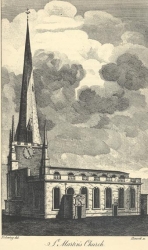
St Martin's Church, Birmingham, Warwickshire
St Martin's Church, Birmingham, Warwickshire is located at latitude 52.476965, longitude -1.893167.
Warwickshire
Warwickshire is located at latitude 52.267317, longitude -1.467361.
Cakemore, Worcestershire
Cakemore, Worcestershire is located at latitude 52.4764270934, longitude -2.0220405513.
Upper Holt Farm, Cakemore, Worcestershire
Upper Holt Farm, Cakemore, Worcestershire is located at latitude 52.4764270934, longitude -2.0220405513.
Halesowen, Worcestershire
Halesowen, Worcestershire is located at latitude 52.450233, longitude -2.050978.
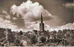
St Johns, Halesowen, Worcestershire
St Johns, Halesowen, Worcestershire is located at latitude 52.450233, longitude -2.050978.
Place References (20)
Parent Place: Halesowen, Worcestershire
1738 Individual: Thomas Clift (chr. Oct 13th, 1738 )
1740 Individual: James Clift (bpt. Jan 18th, 1740 )
1744 Individual: Samuel Clift (chr. Mar 26th, 1744 )
1749 Marriage / Union: James Clift & Ann Smith (m. Sep 24th, 1749 )
1751 Individual: Dorothy Clift (chr. Dec 25th, 1751 )
1755 Individual: Joseph Clift (chr. Jan 26th, 1755 )
1757 Individual: Mary Clift (chr. Apr 24th, 1757 )
1761 Marriage / Union: Joseph Harper & Sarah Forest (m. Oct 5th, 1761 )
1762 Individual: John Harper (chr. Mar 7th, 1762 )
1762 Individual: Hannah Clift (chr. Dec 25th, 1762 )
1764 Individual: Elizabeth Harper (chr. Apr 29th, 1764 )
1766 Individual: Josiah Clift (chr. Nov 2nd, 1766 )
1767 Individual: James Harper (chr. Apr 5th, 1767 )
1770 Individual: Joseph Harper (chr. Apr 15th, 1770 d. 1833 burial. Nov 5th, 1833)
1773 Individual: Sarah Harper (chr. Aug 22nd, 1773 )
1792 Individual: William Harper (chr. Mar 18th, 1792 )
1794 Individual: James Harper (chr. May 25th, 1794 )
1797 Individual: Ann Harper (chr. Jan 8th, 1797 )
1799 Individual: Edward Harper (chr. Mar 10th, 1799 )
Spring Mire, Worcestershire
Spring Mire, Worcestershire is located at latitude 52.498858, longitude -2.104542.
Place References (11)
Parent Place: Worcestershire
1832 Individual: Elizabeth Haywood (b. 1832 )
1841 Occupancy/Contact: Elizabeth Haywood , Mary , William Haywood , John Haywood , Ezekiel Haywood (1841 - 1841)
1851 Individual: Henry James Harper (b. Sep 28th, 1851 )
1856 Occupancy/Contact: Mary Ann Harper (1856 - 1856)
1856 Individual: Mary Ann Harper (b. Apr 25th, 1856 )
1859 Individual: Sarah Harper (b. 1859 )
1860 Individual: William Harper (b. Dec 28th, 1860 )
1861 Occupancy/Contact: William Harper , Sarah Harper (1861 - 1861)
1862 Occupancy/Contact: Ezekiel Harper , James Henry Harper , Elizabeth Haywood (1862 - 1862)
1862 Individual: Ezekiel Harper (b. Dec 27th, 1862 )
Worcestershire
Worcestershire is located at latitude 52.259752, longitude -2.268677.
Akeroyd Fold (no 5), Armley, Leeds, Yorkshire
Akeroyd Fold (no 5), Armley, Leeds, Yorkshire is located at latitude 53.795397, longitude -1.600762.
Akeroyd Road (no 5), Armley, Leeds, Yorkshire
Akeroyd Road (no 5), Armley, Leeds, Yorkshire is located at latitude 53.795397, longitude -1.600762.
Armley Church, Armley, Leeds, Yorkshire
Place Picture Notes
Postcard view of St Bartholomew's Church and graveyard with the Old Chapel to the left. The Old Chapel was thought to date back in part to 1630 and was demolished in 1909. St Bartholomew's was consecrated in 1877 although the tower was not dedicated until 1904.
Armley Church, Armley, Leeds, Yorkshire is located at latitude 53.794384, longitude -1.587117.
Armley, Leeds, Yorkshire
Armley, Leeds, Yorkshire is located at latitude 53.796747, longitude -1.592631.
Place References (73)
Parent Place: Leeds, Yorkshire
1757 Individual: Mary Holmes (b. 1757 bpt. Jul 24th, 1757 )
1777 Individual: Mary Holmes (b. 1777 bpt. Apr 20th, 1777 )
1778 Individual: Ann Holmes (b. Sep 13th, 1778 bpt. Sep 13th, 1778 )
1782 Individual: Sarah Holmes (b. 1782 bpt. Nov 10th, 1782 )
1785 Individual: Thomas Holmes (b. 1785 bpt. Jun 12th, 1785 )
1787 Individual: Ann Holmes (b. 1787 chr. Jul 8th, 1787 d. Jan 1st, 1866 )
1806 Individual: Henry Boynton (b. 1806 )
1808 Individual: John Boynton (b. 1808 d. 1884 )
1808 Individual: Sarah Hudson (b. 1808 d. 1868 )
1811 Individual: Sarah Boynton (b. 1811 )
1813 Individual: Thomas Boynton (b. 1813 bpt. Sep 5th, 1813 )
1815 Individual: Ann Boynton (b. 1815 bpt. Sep 3rd, 1815 d. 1824 )
1818 Individual: Robert Boynton (b. 1818 bpt. Jul 5th, 1818 )
1823 Individual: George Boynton (b. 1823 bpt. May 18th, 1823 )
1823 Individual: Joseph Boynton (b. 1823 bpt. May 18th, 1823 )
1825 Individual: Anne Boynton (b. 1825 bpt. Sep 4th, 1825 )
1828 Individual: William Boynton (b. 1828 d. 1849 )
1830 Individual: Mary Boynton (b. 1830 )
1834 Individual: Samuel Boynton (b. Feb 9th, 1834 )
1838 Individual: Ann Eliza Garforth (b. 1838 )
1839 Occupancy/Contact: William Ellis Boynton , Henry Boynton , Mary Ann Cowgill (1839 - 1839)
1839 Individual: William Ellis Boynton (b. Aug 21st, 1839 d. Mar 1st, 1909 )
1841 Occupancy/Contact: James Hargraves , William Hargraves , Susannah Coates , Hannah Hargraves , Mary Ann Hargraves (1841 - 1841)
1841 Individual: Edward Boynton (b. 1841 bpt. Dec 5th, 1841 )
1843 Individual: Sarah Hargraves (b. 1843 )
1845 Individual: Ann Boynton (b. 1845 )
1845 Individual: Martha Hargraves (b. Feb 12th, 1845 d. 1882 )
1846 Individual: William Hargraves (b. 1846 )
1846 Individual: Robert Boynton (d. Feb 21st, 1846 )
1848 Individual: John Hargraves (b. 1848 )
1849 Individual: Joseph Hargraves (b. 1849 )
1851 Individual: John Cromack (b. 1851 )
1851 Individual: George Hargraves (b. 1851 )
1852 Individual: Thomas Hargraves (b. 1852 )
1853 Individual: Elizabeth Hargraves (b. 1853 )
1855 Individual: Jane Hargraves (b. 1855 )
1856 Individual: Samuel Garforth Boynton (b. 1856 d. Feb 16th, 1857 )
1857 Individual: Mary Brooksbank (b. 1857 )
1858 Individual: Emma Hargraves (b. 1858 )
1858 Individual: Henry Boynton (b. 1858 )
1858 Individual: Mary Braithwaite (b. 1858 )
1859 Individual: Eliza Hargraves (b. 1859 )
1859 Individual: Mark Brooksbank (b. 1859 )
1860 Individual: John Boynton (b. 1860 )
1862 Occupancy/Contact: William Ellis Boynton , Martha Hargraves , Henry Boynton , William Hargraves (1862 - 1862)
1862 Individual: Matilda Brooksbank (b. 1862 )
1862 Individual: Richard Hargraves (b. 1862 )
1864 Individual: Samuel Boynton (b. 1864 )
1864 Individual: Alice Brooksbank (b. 1864 )
1866 Individual: May Ann Boynton (b. 1866 )
1867 Individual: William Ellis Boynton (b. 1867 d. Dec 12th, 1868 )
1867 Individual: James Brooksbank (b. 1867 )
1868 Individual: Annie Shaw (b. 1868 )
1869 Individual: Caroline Brooksbank (b. 1869 )
1871 Individual: Ann Cromack (b. 1871 )
1871 Individual: Walter Boynton (b. 1871 )
1872 Individual: Mary E Butler (b. 1872 )
1873 Individual: Arthur Boynton (b. 1873 )
1875 Individual: Rose Alice Butler (b. 1875 )
1876 Individual: Sarah Emma Boynton (b. 1876 )
1877 Individual: Florence Butler (b. 1877 )
1879 Individual: Ada Alice Boynton (b. 1879 d. Mar 1st, 1896 )
1880 Individual: Eliza Dyson (b. 1880 )
1881 Individual: Jesse Boynton (b. 1881 )
1881 Individual: Mark Butler (b. 1881 )
1887 Individual: Martha Elizabeth Boynton (b. 1887 )
1889 Individual: Louis Boynton (b. 1889 )
1889 Individual: Alice Tordoff (b. 1889 )
1892 Individual: Florence Constantine Boynton (b. 1892 )
1900 Individual: Annie Boynton (b. 1900 )
1904 Individual: Harry Boynton (b. 1904 )
1910 Individual: Nellie Boynton (b. 1910 )
Back Stanley View (no 29), Armley, Leeds, Yorkshire
Back Stanley View (no 29), Armley, Leeds, Yorkshire is located at latitude 53.795499, longitude -1.591827.
Botany Bay, Armley, Leeds, Yorkshire
Botany Bay, Armley, Leeds, Yorkshire is located at latitude 53.801962, longitude -1.579875.
Carr Croft Terrace, Armley, Leeds, Yorkshire
Carr Croft Terrace, Armley, Leeds, Yorkshire is located at latitude 53.794941, longitude -1.594026.
Ely Street (no 5), Armley, Leeds, Yorkshire
Ely Street (no 5), Armley, Leeds, Yorkshire is located at latitude 53.800005, longitude -1.586173.
Far Fold (no 8), Armley, Leeds, Yorkshire
Place Picture Notes
Image shows a view down Far Fold. On the right is a garage with a flat bed lorry parked at the side. On the door of the lorry is printed 57 Stainbeck Road, Leeds 7.
Far Fold (no 8), Armley, Leeds, Yorkshire is located at latitude 53.797974, longitude -1.594736.
Place References (3)
Parent Place: Leeds, Yorkshire
Picture: picture-pic00006.htm
1881 Occupancy/Contact: William Ellis Boynton , Samuel Boynton , May Ann Boynton , Arthur Boynton , Sarah Emma Boynton , Ada Alice Boynton , Jesse Boynton , William Ellis Boynton , Martha Hargraves , Walter Boynton (1881 - 1881)
Goodwin Place (no 2), Armley, Leeds, Yorkshire
Place Picture Notes
Four houses on Goodwin Place, to the right is Goodwin Road, which intersected the Place. Number 8 has a van parked outside, next right is 6, then 4 and 2. This is adjacent to the yard housing dustbins and outside toilets.
Goodwin Place (no 2), Armley, Leeds, Yorkshire is located at latitude 53.791209, longitude -1.590475.
Place Notes
Demolished as part of the Leeds slum clearance program.
Hall Lane, Armley, Leeds, Yorkshire
Hall Lane, Armley, Leeds, Yorkshire is located at latitude 53.795607, longitude -1.581366.
Hill End, Armley (no 13), Leeds, Yorkshire
Place Picture Notes
These old cottages are situated at Hill End off Hill End Road and number from left to right, 15 to 21. The stone wall, right surrounds the substantial gardens belonging to these cottages. Three of the properties have trellising around the doorway. They were demolished in accordance with the Housing Act of 1957.
Hill End, Armley (no 13), Leeds, Yorkshire is located at latitude 53.797837, longitude -1.610994.
Place Notes
Demolished as part of the Leeds slum clearance program.
Place References (2)
Parent Place: Leeds, Yorkshire
1871 Occupancy/Contact: Matilda Brooksbank , Mary Brooksbank , Caroline Brooksbank , Alice Brooksbank , James Brooksbank , John Brooksbank , Mark Brooksbank , Robert Brooksbank , Mary A , Harriet Brooksbank , James Brooksbank , Caroline Roberts (1871 - 1871)
Hill End, Armley, Leeds, Yorkshire
Place Picture Notes
These old cottages are situated at Hill End off Hill End Road and number from left to right, 15 to 21. The stone wall, right surrounds the substantial gardens belonging to these cottages. Three of the properties have trellising around the doorway. They were demolished in accordance with the Housing Act of 1957.
Hill End, Armley, Leeds, Yorkshire is located at latitude 53.797837, longitude -1.610994.
Place Notes
Demolished as part of the Leeds slum clearance program.
Hill Top, Armley, Leeds, Yorkshire
Hill Top, Armley, Leeds, Yorkshire is located at latitude 53.795607, longitude -1.581366.
Lupton's Fold (no 10), Moor Side, Armley, Leeds, Yorkshire
Lupton's Fold (no 10), Moor Side, Armley, Leeds, Yorkshire is located at latitude 53.796418, longitude -1.593704.
Lupton's Fold, Moor Side, Armley, Leeds, Yorkshire
Lupton's Fold, Moor Side, Armley, Leeds, Yorkshire is located at latitude 53.796418, longitude -1.593704.
Place References (6)
Parent Place: Leeds, Yorkshire
Picture: picture-pic00516.htm
1861 Occupancy/Contact: Eliza Hargraves , Elizabeth Hargraves , Emma Hargraves , George Hargraves , James Hargraves , Jane Hargraves , John Hargraves , Joseph Hargraves , Thomas Hargraves , William Hargraves , Martha Hargraves , William Hargraves , Susannah Coates (1861 - 1861)
1881 Occupancy/Contact: John Hargraves , Thomas Hargraves , William Hargraves , Susannah Coates , Richard Hargraves (1881 - 1881)
1882 Occupancy/Contact: William Hargraves , Susannah Coates (1882 - 1882)
1882 Individual: Susannah Coates (d. Mar 13th, 1882 )
Mistress Lane, Armley, Leeds, Yorkshire
Mistress Lane, Armley, Leeds, Yorkshire is located at latitude 53.795607, longitude -1.581366.
Moorside, Armley, Leeds, Yorkshire
Moorside, Armley, Leeds, Yorkshire is located at latitude 53.796817, longitude -1.593275.
Place References (4)
Parent Place: Leeds, Yorkshire
1845 Occupancy/Contact: Martha Hargraves , William Hargraves , Susannah Coates (1845 - 1845)
1851 Occupancy/Contact: George Hargraves , James Hargraves , John Hargraves , Joseph Hargraves , William Hargraves , Martha Hargraves , William Hargraves , Susannah Coates , Sarah Hargraves , Hannah Hargraves , Mary Ann Hargraves (1851 - 1851)
1871 Occupancy/Contact: Elizabeth Hargraves , Emma Hargraves , John Hargraves , Thomas Hargraves , William Hargraves , Susannah Coates , Richard Hargraves (1871 - 1871)
Pinfold Lane, Armley, Leeds, Yorkshire
Place Picture Notes
View shows Hiley's Place off Pinfold Lane. On the left are three blind back terraced houses numbers 1 to 5 with number 7 facing down the street visible at the end. On the right is number 23 Pinfold Lane.
Pinfold Lane, Armley, Leeds, Yorkshire is located at latitude 53.796912, longitude -1.592423.
Place Notes
Demolished as part of the Leeds slum clearance program.
Place References (12)
Parent Place: Leeds, Yorkshire
Picture: picture-pic00005.htm
1841 Occupancy/Contact: Samuel Boynton , William Ellis Boynton , Henry Boynton , Mary Ann Cowgill (1841 - 1841)
1851 Occupancy/Contact: Martha Ann Boynton , Samuel Boynton (1851 - 1851)
1851 Occupancy/Contact: Eliza Harriet Boynton , Henry Boynton (1851 - 1851)
1851 Occupancy/Contact: George Boynton , Sarah Fowler (1851 - 1851)
1851 Individual: Eliza Harriet Boynton (b. Jul 7th, 1851 )
1871 Occupancy/Contact: Samuel Boynton , May Ann Boynton , Joseph Hargraves , William Ellis Boynton , Martha Hargraves , Walter Boynton (1871 - 1871)
1874 Occupancy/Contact: William Ellis Boynton , William Ellis Boynton , Martha Hargraves (1874 - 1874)
1874 Individual: William Ellis Boynton (b. Mar 27th, 1874 )
1879 Individual: Mary Ann Cowgill (d. Jul 30th, 1879 )
1971 Occupancy/Contact: Eliza Harriet Boynton , John Cromack , Ann Cromack (1971 - 1971)
Punch Yard, Armley, Leeds, Yorkshire
Punch Yard, Armley, Leeds, Yorkshire is located at latitude 53.797337, longitude -1.587192.
Redcote Lane, Armley, Leeds, Yorkshire
Redcote Lane, Armley, Leeds, Yorkshire is located at latitude 53.806252, longitude -1.589842.
St Bartholomew, Armley, Leeds, Yorkshire
Place Picture Notes
Postcard view of St Bartholomew's Church and graveyard with the Old Chapel to the left. The Old Chapel was thought to date back in part to 1630 and was demolished in 1909. St Bartholomew's was consecrated in 1877 although the tower was not dedicated until 1904.
St Bartholomew, Armley, Leeds, Yorkshire is located at latitude 53.794384, longitude -1.587117.
Stanley View (no 9), Armley, Leeds, Yorkshire
Stanley View (no 9), Armley, Leeds, Yorkshire is located at latitude 53.795296, longitude -1.590614.
Town Gate, Armley, Leeds, Yorkshire
Town Gate, Armley, Leeds, Yorkshire is located at latitude 53.797451, longitude -1.60027.
Place Notes
Another name for Town Street
Winker Green, Armley, Leeds, Yorkshire
Place Picture Notes
Winker Green nos. 14, 15, 16. Image shows a row of four back-to-back terraced houses on a cobled street. On the far left is the entrance to Eyres Place and on the right is a shared outside toilet block where a sig reads 'No Entry' to heavy traffic.
Winker Green, Armley, Leeds, Yorkshire is located at latitude 53.798205, longitude -1.59276.
Bowes Parish, Yorkshire
Bowes Parish, Yorkshire is located at latitude 54.496365, longitude -2.035904.
Bradford, Yorkshire
Bradford, Yorkshire is located at latitude 53.793853, longitude -1.752442.
Bramhope, Yorkshire
Bramhope, Yorkshire is located at latitude 53.883171, longitude -1.612287.
Moor Side, Bramhope, Leeds, Yorkshire
Moor Side, Bramhope, Leeds, Yorkshire is located at latitude 53.881324, longitude -1.625633.
Bramley, Leeds, Yorkshire
Bramley, Leeds, Yorkshire is located at latitude 53.809876, longitude -1.631277.
Dickinson Yard, Bramley, Leeds, Yorkshire
Dickinson Yard, Bramley, Leeds, Yorkshire is located at latitude 53.800651, longitude -1.634517.
Gamble Hill, Bramley, Leeds, Yorkshire
Gamble Hill, Bramley, Leeds, Yorkshire is located at latitude 53.79747, longitude -1.622393.
Henconner Lane, Bramley, Leeds, Yorkshire
Henconner Lane, Bramley, Leeds, Yorkshire is located at latitude 53.799384, longitude -1.620355.
Killingbeck's Yard, Bramley, Leeds, Yorkshire
Killingbeck's Yard, Bramley, Leeds, Yorkshire is located at latitude 53.800651, longitude -1.634517.
Lower Gamble Hill, Bramley, Leeds, Yorkshire
Lower Gamble Hill, Bramley, Leeds, Yorkshire is located at latitude 53.79747, longitude -1.622393.
New York, Bramley, Leeds, Yorkshire
New York, Bramley, Leeds, Yorkshire is located at latitude 53.800651, longitude -1.634517.
Providence Place, Bramley, Leeds, Yorkshire
Providence Place, Bramley, Leeds, Yorkshire is located at latitude 53.812669, longitude -1.628262.
Place Notes
This street no longer exists
Scarborough Terrace (no 13), Bramley, Leeds, Yorkshire
Scarborough Terrace (no 13), Bramley, Leeds, Yorkshire is located at latitude 53.806591, longitude -1.629050.
Place Notes
This street no longer exists
Burley, Leeds, Yorkshire
Burley, Leeds, Yorkshire is located at latitude 53.811497, longitude -1.586816.
Parish Church, Burley, Leeds, Yorkshire
Parish Church, Burley, Leeds, Yorkshire is located at latitude 53.812916, longitude -1.578083.
Charlestown, Yorkshire
Charlestown, Yorkshire is located at latitude 53.736122, longitude -2.044058.
Bachelor Street (no 48), Cross Green, Leeds, Yorkshire
Bachelor Street (no 48), Cross Green, Leeds, Yorkshire is located at latitude 53.792577, longitude -1.526198.
Place Notes
Demolished as part of the Leeds slum clearance program.
Grand Street (no 45), Cross Green, Leeds, Yorkshire
Grand Street (no 45), Cross Green, Leeds, Yorkshire is located at latitude 53.791956, longitude -1.528194.
Sussex Court (no 6), Cross Green, Leeds, Yorkshire
Sussex Court (no 6), Cross Green, Leeds, Yorkshire is located at latitude 53.793161, longitude -1.523473.
Dewsbury, Yorkshire
Dewsbury, Yorkshire is located at latitude 53.691218, longitude -1.633015.
Birwick, Draughton, Yorkshire
Birwick, Draughton, Yorkshire is located at latitude 53.968255, longitude -1.933948.
East Bierley, Yorkshire
East Bierley, Yorkshire is located at latitude 53.765456, longitude -1.704426.
Farnley, Yorkshire
Farnley, Yorkshire is located at latitude 53.787266, longitude -1.613016.
Fewston, Yorkshire
Fewston, Yorkshire is located at latitude 53.983046, longitude -1.705799.
Place References (11)
Parent Place: Yorkshire
1742 Individual: John Snell (b. 1742 bpt. Feb 14th, 1742 d. May 9th, 1742 )
1743 Individual: Anne Snell (b. 1743 bpt. Apr 10th, 1743 )
1746 Individual: Anthony Snell (b. 1746 bpt. Jul 25th, 1746 )
1750 Individual: Richard Snell (b. 1750 bpt. Apr 14th, 1750 )
1753 Individual: Mary Snell (b. 1753 bpt. Feb 26th, 1753 )
1773 Individual: Ann Snell (b. 1773 bpt. Feb 8th, 1773 )
1775 Individual: Isabel Snell (b. 1775 bpt. Jan 4th, 1775 )
1776 Individual: Sarah Snell (b. 1776 bpt. Oct 6th, 1776 d. Feb 13th, 1777 )
1801 Individual: Mary Bodes (d. Feb 1801 )
1807 Individual: Francis Mountaine (d. Feb 1807 )
Birdacre, Gomersal, Yorkshire
Birdacre, Gomersal, Yorkshire is located at latitude 53.7314, longitude -1.684341.
Hull, Yorkshire
Hull, Yorkshire is located at latitude 53.744244, longitude -0.33165.
Hunslet Cemetary, Leeds, Yorkshire
Hunslet Cemetary, Leeds, Yorkshire is located at latitude 53.768475, longitude -1.522422.
Hunslet, Leeds, Yorkshire
Hunslet, Leeds, Yorkshire is located at latitude 53.778493, longitude -1.522636.
Place References (24)
Parent Place: Leeds, Yorkshire
1778 Individual: James Roberts (b. 1778 )
1781 Individual: William Roberts (b. 1781 )
1782 Individual: Rachel Roberts (b. May 28th, 1782 )
1796 Individual: Mary Roberts (b. 1796 )
1797 Individual: William Roberts (b. Sep 24th, 1797 )
1800 Individual: John Roberts (b. Oct 19th, 1800 )
1802 Individual: James Roberts (b. Oct 22nd, 1802 )
1805 Individual: Hannah Roberts (b. 1805 )
1807 Individual: Esther Roberts (b. Apr 25th, 1807 )
1809 Individual: Sarah Roberts (b. Mar 20th, 1809 )
1811 Individual: Elizabeth Roberts (b. Apr 6th, 1811 )
1814 Individual: Thomas Roberts (b. 1814 )
1826 Individual: Robert Richardson Roberts (b. 1826 )
1831 Individual: Caroline Roberts (b. 1831 )
1833 Individual: Matilda Roberts (b. 1833 )
1846 Individual: Martha Ann Boynton (b. 1846 )
1856 Individual: Samuel Roberts (d. Jun 20th, 1856 )
1895 Individual: Harry Briggs (b. 1895 )
1896 Individual: William Briggs (b. 1896 )
1908 Individual: Edna May Briggs (b. 1908 )
1911 Individual: Edith Annie Boynton (b. 1911 d. 1911 )
1916 Individual: Mark Boynton (b. Nov 16th, 1916 )
1923 Individual: William Ellis Boynton (d. 1923 )
Royal Terrace (no 5), Royal Road, Hunslet Carr, Leeds, Yorkshire
Place Picture Notes
View looks from Wheater Street. On the left edge, a house on Royal Grove can be seen. On the right are two through properties on Royal Terrace, numbers 18 and 16, which were numbers 17 and 15 Royal Grove on the other side.
Royal Terrace (no 5), Royal Road, Hunslet Carr, Leeds, Yorkshire is located at latitude 53.761144, longitude -1.535425.
St Mary the Virgin, Hunslet, Leeds, Yorkshire
St Mary the Virgin, Hunslet, Leeds, Yorkshire is located at latitude 53.777738, longitude -1.529272.
Accommodation Square (no 3), Leeds, Yorkshire
Accommodation Square (no 3), Leeds, Yorkshire is located at latitude 53.799662, longitude -1.549115.
Ascot Avenue (no 12), Leeds, Yorkshire
Place Picture Notes
Image shows shop at junction of Ascot Avenue and Pontefract Lane. Two women walk towards the N.Dransfield greengrocery & provisions store from the left, while another woman crosses the street on the right to reach the store. Above the shop are two advertisements for Dettol on the left and Sharp & Thornton furniture store on the right. On the right a row of back-to-back terraces are visible with a car, reg: 408 DUM parked outside.
Ascot Avenue (no 12), Leeds, Yorkshire is located at latitude 53.795515, longitude -1.519306.
Place Notes
Demolished as part of the Leeds slum clearance program.
Ascot Avenue (no 7), Leeds, Yorkshire
Place Picture Notes
Image shows shop at junction of Ascot Avenue and Pontefract Lane. Two women walk towards the N.Dransfield greengrocery & provisions store from the left, while another woman crosses the street on the right to reach the store. Above the shop are two advertisements for Dettol on the left and Sharp & Thornton furniture store on the right. On the right a row of back-to-back terraces are visible with a car, reg: 408 DUM parked outside.
Ascot Avenue (no 7), Leeds, Yorkshire is located at latitude 53.795515, longitude -1.519306.
Ascot Street (no 16), Leeds, Yorkshire
Place Picture Notes
Image shows two double fronted back-to-back terraced houses with glazed windows. On the left is a yard originally built to house the shared toilet and midden. Two archways at pavement level between the doors show where the basement windows were before road improvements raised the height of the street and pavement, blocking them off. A washing line hangs across the window of number 14.
Ascot Street (no 16), Leeds, Yorkshire is located at latitude 53.795905, longitude -1.519524.
Place Notes
Demolished as part of the Leeds slum clearance program.
Ascot Terrace (no 12), Leeds, Yorkshire
Ascot Terrace (no 12), Leeds, Yorkshire is located at latitude 53.795328, longitude -1.517508.
Bath Street (no 10), Leeds, Yorkshire
Place Picture Notes
View of Bath Street looking west, towards the York Road Public Library and Swimming Baths building seen in the backround on the left. In the foreground is a cleared area where houses have been demolished. York Road can be seen on the right, with the business of Harold Pynt, furniture dealer, at no.113, just visible across the road.
Bath Street (no 10), Leeds, Yorkshire is located at latitude 53.797723, longitude -1.519439.
Bath Street (no 22), Leeds, Yorkshire
Place Picture Notes
View of Bath Street looking west, towards the York Road Public Library and Swimming Baths building seen in the backround on the left. In the foreground is a cleared area where houses have been demolished. York Road can be seen on the right, with the business of Harold Pynt, furniture dealer, at no.113, just visible across the road.
Bath Street (no 22), Leeds, Yorkshire is located at latitude 53.797723, longitude -1.519439.
Bath Street (no 9), Leeds, Yorkshire
Place Picture Notes
View of Bath Street looking west, towards the York Road Public Library and Swimming Baths building seen in the backround on the left. In the foreground is a cleared area where houses have been demolished. York Road can be seen on the right, with the business of Harold Pynt, furniture dealer, at no.113, just visible across the road.
Bath Street (no 9), Leeds, Yorkshire is located at latitude 53.797723, longitude -1.519439.
Bath Street, Leeds, Yorkshire
Place Picture Notes
View of Bath Street looking west, towards the York Road Public Library and Swimming Baths building seen in the backround on the left. In the foreground is a cleared area where houses have been demolished. York Road can be seen on the right, with the business of Harold Pynt, furniture dealer, at no.113, just visible across the road.
Bath Street, Leeds, Yorkshire is located at latitude 53.797723, longitude -1.519439.
Beckett Street (no 123) (St James Hospital), Leeds, Yorkshire
Beckett Street (no 123) (St James Hospital), Leeds, Yorkshire is located at latitude 53.807335, longitude -1.521971.
Bell Street (no 19), Leeds, Yorkshire
Place Picture Notes
View looking west to the back of Star Street. A cul-de-sac of dwellings in the Leeds Unhealthy Areas programme of 1901. At the end of the street is a horse and cart. A large number of children in period dress pose for the camera.
Bell Street (no 19), Leeds, Yorkshire is located at latitude 53.800454, longitude -1.533237.
Blayds Street (no 9), Leeds, Yorkshire
Blayds Street (no 9), Leeds, Yorkshire is located at latitude 53.795708, longitude -1.520212.
Boynton Street (no 2), Leeds, Yorkshire
Place Picture Notes
A long street off Quarry Hill which varied in width. Dwellings also varied in size, to the left, a row of cottages with basements which had access from the street, beneath the railed areas. A block of outside toilets is facing down the street. Houses on the right vary in size. A telegraph pole is visible.
Boynton Street (no 2), Leeds, Yorkshire is located at latitude 53.797511, longitude -1.530635.
Place Notes
Demolished as part of the Leeds slum clearance program.
Boynton Street (no 40), Leeds, Yorkshire
Boynton Street (no 40), Leeds, Yorkshire is located at latitude 53.797511, longitude -1.530635.
Brick Street (no 12), Leeds, Yorkshire
Brick Street (no 12), Leeds, Yorkshire is located at latitude 53.796278, longitude -1.532614.
Brick Street (no 13), Leeds, Yorkshire
Brick Street (no 13), Leeds, Yorkshire is located at latitude 53.796278, longitude -1.532614.
Brick Street, Leeds, Yorkshire
Brick Street, Leeds, Yorkshire is located at latitude 53.796278, longitude -1.532614.
Britannia Road (no 4), Morley, Leeds, Yorkshire
Britannia Road (no 4), Morley, Leeds, Yorkshire is located at latitude 53.737455, longitude -1.61128.
Place References (2)
Parent Place: Leeds, Yorkshire
1901 Occupancy/Contact: Joseph Butler , Mary Braithwaite , Ellen Butler , Sarah E Butler , Harry Butler , Sam Butler , Isaac Butler , Willie Butler , Annie Butler , Louie Butler , John Butler (1901 - 1901)
Call Lane, Leeds, Yorkshire
Call Lane, Leeds, Yorkshire is located at latitude 53.796405, longitude -1.539921.
Cariss Terrace (no 11), Hunslet, Leeds, Yorkshire
Place Picture Notes
Looking from Joseph Street along Cariss Terrace, number 11 is on the left. Moving right numbers follow is sequence to 19 on the right.
Cariss Terrace (no 11), Hunslet, Leeds, Yorkshire is located at latitude 53.781631, longitude -1.529664.
Charlton Street (no 9), Leeds, Yorkshire
Charlton Street (no 9), Leeds, Yorkshire is located at latitude 53.794472, longitude -1.513656.
Cottage Street, Leeds, Yorkshire
Cottage Street, Leeds, Yorkshire is located at latitude 53.797559, longitude -1.518795.
Dunns Yard (no 3), Leeds, Yorkshire
Dunns Yard (no 3), Leeds, Yorkshire is located at latitude 53.796015, longitude -1.532904.
Dunns Yard (no 5), Leeds, Yorkshire
Dunns Yard (no 5), Leeds, Yorkshire is located at latitude 53.796015, longitude -1.532904.
East Street (no 80), Leeds, Yorkshire
East Street (no 80), Leeds, Yorkshire is located at latitude 53.793199, longitude -1.530962.
Place References (5)
Parent Place: Leeds, Yorkshire
1871 Occupancy/Contact: David Storey , Sarah Ann Storey , David Henry Storey , John William Storey , Hannah , Emmeline Storey , Elizabeth Storey (1871 - 1871)
1881 Occupancy/Contact: David Storey , Sarah Ann Storey , Hannah , Emmeline Storey , Elizabeth Storey (1881 - 1881)
1885 Occupancy/Contact: David Storey (1885 - 1885)
1885 Individual: David Storey (d. Mar 10th, 1885 )
General Infirmary, Leeds, Yorkshire
General Infirmary, Leeds, Yorkshire is located at latitude 53.802045, longitude -1.550746.
Great Garden Street, Leeds, Yorkshire
Place Picture Notes
Corner of Great Garden Street and Accommodation Road, showing corner shop with wall advertising for Mansion Polish; children playing in street and group of men on doorstep. Property shown belongs to one Clara Sutcliffe.
Great Garden Street, Leeds, Yorkshire is located at latitude 53.799567, longitude -1.524836.
Place Notes
Demolished as part of the Leeds slum clearance program.
Headingley, Leeds, Yorkshire
Headingley, Leeds, Yorkshire is located at latitude 53.820517, longitude -1.578555.
Holbeck, Leeds, Yorkshire
Holbeck, Leeds, Yorkshire is located at latitude 53.788686, longitude -1.55611.
Holiday Yard, Kirkgate, Leeds, Yorkshire
Holiday Yard, Kirkgate, Leeds, Yorkshire is located at latitude 53.795911, longitude -1.539014.
Horsforth, Leeds, Yorkshire
Horsforth, Leeds, Yorkshire is located at latitude 53.841083, longitude -1.663485.
Joy's Fold (no 14), Leeds, Yorkshire
Joy's Fold (no 14), Leeds, Yorkshire is located at latitude 53.798091, longitude -1.527936.
Jubber Gate, Leeds, Yorkshire
Jubber Gate, Leeds, Yorkshire is located at latitude 53.785162, longitude -1.604422.
Killingbeck Hospital, Leeds, Yorkshire
Place Picture Notes
The hospital opened in 1904 and was finally closed in 1997. It had been first a smallpox hospital, then a TB sanotorium and became a renowned centre for the treatment of chest diseases, also noted for heart surgery.
Killingbeck Hospital, Leeds, Yorkshire is located at latitude 53.808925, longitude -1.478605.
Place Notes
The hospital opened in 1904 and was finally closed in 1997. It had been first a smallpox hospital, then a TB sanotorium and became a renowned centre for the treatment of chest diseases, also noted for heart surgery.
Kippax View (no 5), Leeds, Yorkshire
Kippax View (no 5), Leeds, Yorkshire is located at latitude 53.793737, longitude -1.520126.
Place Notes
This street no longer exists
Kirkgate (no 82), Leeds, Yorkshire
Kirkgate (no 82), Leeds, Yorkshire is located at latitude 53.795911, longitude -1.539014.
Kirkgate, Leeds, Yorkshire
Kirkgate, Leeds, Yorkshire is located at latitude 53.795911, longitude -1.539014.
Lady Lane, Leeds, Yorkshire
Place Picture Notes
View looking down Lady Lane to St Peter's Street. Junction on left is Edward Street with factory of Henry Thorne at number 9. Sign advertising Cocoa can be partly seen on wall. The junction on the right is with Harewood Street. The end wall of premises has many advertisements including Wills' Gold Flake cigarettes, Hookers Malted Milk, Nestle's milk, Palestine Wine and Trading Co, which is written in Hebrew. Wolsey Car, which can be bought for £250, Cerebos salt, Ideal Milk, one bearing the advice 'To eat more fruit'. There are also a number of cinema and event posters. The Capitol Ballroom and cinema at Meanwood, The Regent Picture House showing Dorothy Phillips in 'Slender is a Woman', the Harehills Picture House, the Harehills Arcadian Pavilian. The Town Hall in Leeds has a 'biblical masquerade ball' on the Esater Monday. On April 19th Leeds United are playing Preston North End at Elland Road.
Lady Lane, Leeds, Yorkshire is located at latitude 53.79913, longitude -1.538172.
Leeds Chapelry of Armley, Leeds, Yorkshire
Leeds Chapelry of Armley, Leeds, Yorkshire is located at latitude 53.794493, longitude -1.587061.
Leeds Union Infirmary, Leeds, Yorkshire
Leeds Union Infirmary, Leeds, Yorkshire is located at latitude 53.807335, longitude -1.521971.
Leeds, Yorkshire
Leeds, Yorkshire is located at latitude 53.799612, longitude -1.549115.
Place References (240)
Parent Place: Yorkshire
Place: Bachelor Street (no 48), Cross Green, Leeds, Yorkshire
Place: Grand Street (no 45), Cross Green, Leeds, Yorkshire
Place: Sussex Court (no 6), Cross Green, Leeds, Yorkshire
Place: Upper Somerset Street (no 13), Leeds, Yorkshire
Place: Back Stanley View (no 29), Armley, Leeds, Yorkshire
Place: Bramley, Leeds, Yorkshire
Place: Hayfield Street (no 10), Wortley, Leeds, Yorkshire
Place: Hayfield Street (no 18), Wortley, Leeds, Yorkshire
Place: Goodwin Place (no 1), Wortley, Leeds, Yorkshire
Place: Pinfold Lane, Armley, Leeds, Yorkshire
Place: Far Fold (no 8), Armley, Leeds, Yorkshire
Place: Akeroyd Road (no 5), Armley, Leeds, Yorkshire
Place: Armley, Leeds, Yorkshire
Place: Hunslet, Leeds, Yorkshire
Place: Wortley, Leeds, Yorkshire
Place: Hill End, Armley (no 13), Leeds, Yorkshire
Place: Moresdale Lane (no 24), Seacroft, Leeds, Yorkshire
Place: Holbeck, Leeds, Yorkshire
Place: High Street, Leeds, Yorkshire
Place: Brick Street, Leeds, Yorkshire
Place: Brick Street (no 13), Leeds, Yorkshire
Place: Accommodation Square (no 3), Leeds, Yorkshire
Place: Temple View Place (no 7), Leeds, Yorkshire
Place: Temple View Place (no 2), Leeds, Yorkshire
Place: Shannon Street (no 13), Leeds, Yorkshire
Place: Bath Street (no 9), Leeds, Yorkshire
Place: Horsforth, Leeds, Yorkshire
Place: Hall Lane, Armley, Leeds, Yorkshire
Place: St Stephens, Leeds, Yorkshire
Place: Great Garden Street, Leeds, Yorkshire
Place: Bath Street (no 22), Leeds, Yorkshire
Place: Lower Wortley, Leeds, Yorkshire
Place: Tenters, Leeds, Yorkshire
Place: Mistress Lane, Armley, Leeds, Yorkshire
Place: Goodwin Terrace, Wortley, Leeds, Yorkshire
Place: Hill End, Armley, Leeds, Yorkshire
Place: Brick Street (no 12), Leeds, Yorkshire
Place: Call Lane, Leeds, Yorkshire
Place: Lady Lane, Leeds, Yorkshire
Place: York Road, Leeds, Yorkshire
Place: Bath Street, Leeds, Yorkshire
Place: Pine Court (no 20), Leeds, Yorkshire
Place: Cottage Street, Leeds, Yorkshire
Place: Bath Street (no 10), Leeds, Yorkshire
Place: Headingley, Leeds, Yorkshire
Place: Linsley Row (no 24), Leeds, Yorkshire
Place: Joy's Fold (no 14), Leeds, Yorkshire
Place: Blayds Street (no 9), Leeds, Yorkshire
Place: Jubber Gate, Leeds, Yorkshire
Place: Hill Top, Armley, Leeds, Yorkshire
Place: Hayfield Street (no 2), Wortley, Leeds, Yorkshire
Place: Strode Street (no 2), Leeds, Yorkshire
Place: Lupton's Fold, Moor Side, Armley, Leeds, Yorkshire
Place: Dunns Yard (no 5), Leeds, Yorkshire
Place: Marsh Lane (no 79), Leeds, Yorkshire
Place: Dunns Yard (no 3), Leeds, Yorkshire
Place: Strode Street (no 7), Leeds, Yorkshire
Place: East Street (no 80), Leeds, Yorkshire
Place: Akeroyd Fold (no 5), Armley, Leeds, Yorkshire
Place: Hunslet Cemetary, Leeds, Yorkshire
Place: Oakley Place (no 12), New Wortley, Yorkshire
Place: General Infirmary, Leeds, Yorkshire
Place: Acre Mount (no 2), Middleton, Leeds, Yorkshire
Place: St James Church, Seacroft, Leeds, Yorkshire
Place: St Gemmas Hospice, Leeds, Yorkshire
Place: Killingbeck Hospital, Leeds, Yorkshire
Place: St Georges Hospital, Rothwell, Leeds, Yorkshire
Place: Wheeler Street, Leeds, Yorkshire
Place: Richmond Road, Leeds, Yorkshire
Place: St Marys Church, Middleton, Leeds, Yorkshire
Place: Parish Church, Burley, Leeds, Yorkshire
Place: Armley Church, Armley, Leeds, Yorkshire
Place: St Bartholomew, Armley, Leeds, Yorkshire
Place: Providence Place, Bramley, Leeds, Yorkshire
Place: Royal Terrace (no 5), Royal Road, Hunslet Carr, Leeds, Yorkshire
Place: Goodwin Place (no 2), Armley, Leeds, Yorkshire
Place: Granny Lane, Wortley, Leeds, Yorkshire
Place: Town Gate, Armley, Leeds, Yorkshire
Place: Winker Green, Armley, Leeds, Yorkshire
Place: Botany Bay, Armley, Leeds, Yorkshire
Place: Bell Street (no 19), Leeds, Yorkshire
Place: Gamble Hill, Bramley, Leeds, Yorkshire
Place: Punch Yard, Armley, Leeds, Yorkshire
Place: Lower Gamble Hill, Bramley, Leeds, Yorkshire
Place: Moorside, Armley, Leeds, Yorkshire
Place: Killingbeck's Yard, Bramley, Leeds, Yorkshire
Place: Dickinson Yard, Bramley, Leeds, Yorkshire
Place: Scarborough Terrace (no 13), Bramley, Leeds, Yorkshire
Place: Ely Street (no 5), Armley, Leeds, Yorkshire
Place: Redcote Lane, Armley, Leeds, Yorkshire
Place: Stanley View (no 9), Armley, Leeds, Yorkshire
Place: Charlton Street (no 9), Leeds, Yorkshire
Place: Kingswood Road (no 9), Thornhill Road, Wortley, Leeds, Yorkshire
Place: Kippax View (no 5), Leeds, Yorkshire
Place: St Mary the Virgin, Hunslet, Leeds, Yorkshire
Place: Carr Croft Terrace, Armley, Leeds, Yorkshire
Place: Burley, Leeds, Yorkshire
Place: Lupton's Fold (no 10), Moor Side, Armley, Leeds, Yorkshire
Place: Moor Side, Bramhope, Leeds, Yorkshire
Place: Upper Wortley Road (no 100, house & shop), Leeds, Yorkshire
Place: St James Hospital, Leeds, Yorkshire
Place: Holiday Yard, Kirkgate, Leeds, Yorkshire
Place: Wheat Street (no 49), Leeds, Yorkshire
Place: Kirkgate (no 82), Leeds, Yorkshire
Place: Beckett Street (no 123) (St James Hospital), Leeds, Yorkshire
Place: Ascot Street (no 16), Leeds, Yorkshire
Place: Ascot Avenue (no 7), Leeds, Yorkshire
Place: Ascot Avenue (no 12), Leeds, Yorkshire
Place: Cariss Terrace (no 11), Hunslet, Leeds, Yorkshire
Place: Boynton Street (no 40), Leeds, Yorkshire
Place: Boynton Street (no 2), Leeds, Yorkshire
Place: Ascot Street (no 16), Leeds, Yorkshire
Place: Kirkgate, Leeds, Yorkshire
Place: Ascot Terrace (no 12), Leeds, Yorkshire
Place: Swinegate, Leeds, Yorkshire
Place: Leeds Union Infirmary, Leeds, Yorkshire
Place: Randerson's Yard, Leeds, Yorkshire
Place: Workhouse, Leeds, Yorkshire
Place: Off Street (no 32), Leeds, Yorkshire
Place: Town Street, Bramley, Leeds, Yorkshire
Place: St Peters Parish Church, Leeds, Yorkshire
Place: Mabgate, Leeds, Yorkshire
Place: Lemon Street, Leeds, Yorkshire
Place: Plane Street (no 11), Leeds, Yorkshire
Place: Little Lemon Street (no 11), Leeds, Yorkshire
Place: Stone Street (no 9), Leeds, Yorkshire
Place: Pinfold Lane (no 10), Armley, Leeds, Yorkshire
Place: Leeds Chapelry of Armley, Leeds, Yorkshire
Place: St John the Baptist, Adel, Leeds, Yorkshire
Place: Henconner Lane, Bramley, Leeds, Yorkshire
Place: New York, Bramley, Leeds, Yorkshire
Place: Britannia Road (no 4), Morley, Leeds, Yorkshire
Place: Morley, Leeds, Yorkshire
1650 Individual: Joseph Roberts (b. 1650 )
1660 Individual: John Harrison (b. 1660 )
1692 Individual: Benjamin Roberts (b. Dec 24th, 1692 )
1695 Individual: Hannah Harrison (b. 1695 )
1725 Individual: Esther Leathley (b. 1725 )
1725 Individual: Mary Holm (b. Feb 15th, 1725 )
1725 Individual: John Mann (b. May 14th, 1725 )
1727 Individual: John Holms (b. Feb 10th, 1727 )
1730 Individual: Mary Mann (b. Jan 16th, 1730 )
1743 Individual: Joshua Mans (b. Feb 6th, 1743 )
1746 Individual: Rosamund Man (b. May 12th, 1746 )
1794 Individual: John Germaine (b. 1794 )
1795 Marriage / Union: Samuel Roberts & Ann King (m. Apr 6th, 1795 )
1816 Individual: Thomas Gale (b. Jun 2nd, 1816 )
1818 Individual: John Gale (b. Jun 3rd, 1818 )
1820 Individual: David Storey (b. 1820 )
1820 Individual: Sarah Booth (b. 1820 )
1820 Individual: William Gale (b. Apr 30th, 1820 )
1821 Individual: John Robinson (b. 1821 )
1821 Individual: Ann Booth (b. 1821 )
1822 Individual: John Smith (b. 1822 )
1822 Individual: Harriet Booth (b. 1822 )
1823 Individual: Elizabeth Jordan (b. 1823 )
1823 Marriage / Union: James Roberts & Harriet Richardson (m. Jul 3rd, 1823 )
1824 Individual: Sarah Gale (b. Mar 3rd, 1824 )
1825 Individual: Betsey Storey (b. 1825 )
1825 Individual: Mary Germaine (b. 1825 )
1825 Individual: John Jordan (b. 1825 )
1825 Individual: Sarah Fowler (b. 1825 )
1825 Individual: James Booth (b. 1825 )
1826 Individual: Maria Pickles (b. 1826 )
1826 Individual: Mary Robinson (b. 1826 )
1826 Individual: Ann Gale (b. Jun 5th, 1826 )
1828 Individual: Elizabeth Booth (b. 1828 )
1828 Individual: Joshua Robinson (b. 1828 )
1828 Individual: John Gale (b. Nov 19th, 1828 )
1829 Individual: William Roberts (b. 1829 )
1831 Individual: Hannah (b. 1831 )
1831 Individual: William Germaine (b. 1831 )
1831 Individual: Martha Booth (b. 1831 )
1831 Individual: Lydia Gale (b. May 10th, 1831 )
1832 Individual: Eliza Booth (b. 1832 )
1833 Individual: Ellen Robinson (b. 1833 d. 1880 )
1837 Individual: Benjamin Smith (b. 1837 )
1837 Individual: Mary Booth (b. 1837 )
1841 Individual: James Smith (b. 1841 )
1841 Individual: Elizabeth Boynton (b. 1841 )
1844 Individual: George Storey (b. 1844 )
1844 Individual: Elizabeth Smith (b. 1844 )
1846 Individual: Emily Elizabeth Boynton (b. 1846 )
1849 Individual: Joseph Storey (b. 1849 )
1849 Individual: Mary E Smith (b. 1849 )
1850 Individual: Sarah Jane Smith (b. 1850 )
1850 Individual: Sarah Ann Storey (b. 1850 )
1850 Individual: Sarah A Smith (b. 1850 )
1851 Individual: Elizabeth Smith (b. 1851 )
1851 Individual: Elizabeth Gale (b. 1851 )
1852 Individual: Louisa Smith (b. 1852 )
1853 Individual: Charlotte Smith (b. 1853 )
1854 Individual: John William Storey (b. 1854 )
1854 Individual: James Roberts (d. 1854 )
1854 Marriage / Union: Jonas Carter & Ellen Robinson (m. 1854 )
1855 Individual: Thomas Gale (b. 1855 )
1856 Individual: David Henry Storey (b. 1856 )
1856 Individual: Mitchell Carter (b. 1856 d. 1922 )
1856 Individual: Jonas Carter (d. 1856 )
1857 Individual: Betty Smith (b. 1857 )
1857 Marriage / Union: Thomas Thwaites & Ellen Robinson (m. 1857 )
1858 Individual: Ellen Gale (b. 1858 )
1858 Individual: Elizabeth Ann Thwaites (b. 1858 d. 1862 )
1861 Individual: Charles Smith (b. 1861 )
1861 Individual: Hannah Gale (b. 1861 )
1861 Individual: Isabella Thwaites (b. 1861 d. May 24th, 1914 )
1862 Individual: Emmeline Storey (b. 1862 )
1864 Individual: Christopher Thwaites (b. 1864 )
1865 Individual: Elizabeth Storey (b. 1865 )
1865 Marriage / Union: Charles Smith & Mary Ann Storey (m. Jul 8th, 1865 )
1866 Individual: Elizabeth Ann Thwaites (b. 1866 )
1867 Individual: Sarah Ellen Thwaites (b. 1867 )
1868 Individual: David Smith (b. 1868 )
1868 Individual: Robert Boynton (d. 1868 )
1868 Individual: Thomas Briggs (b. 1868 )
1870 Individual: Sarah Elizabeth Smith (b. 1870 )
1871 Individual: Charles Smith (b. 1871 )
1875 Individual: John Smith (b. 1875 )
1877 Marriage / Union: Joseph Butler & Mary Braithwaite (m. 1877 )
1877 Individual: Ada Smith (b. Sep 8th, 1877 )
1878 Individual: Frederick Smith (b. 1878 )
1880 Individual: James Smith (b. 1880 )
1886 Individual: Herbert Smith (b. 1886 )
1889 Individual: Mary Smith (b. 1889 )
1891 Individual: Mabel Briggs (b. Nov 16th, 1891 d. 1973 )
1893 Individual: Lawrence Briggs (b. 1893 )
1896 Individual: Louie Butler (b. 1896 )
1898 Individual: Anne Boynton (d. 1898 )
1900 Individual: Herbert Smith (b. Oct 17th, 1900 )
1901 Individual: George Arthur Boynton (b. Aug 10th, 1901 d. Mar 2nd, 1959 )
1902 Individual: Lily Robinson (b. Nov 12th, 1902 d. Dec 25th, 1975 )
1903 Individual: Leonard Smith (b. Jul 22nd, 1903 d. 1959 )
1906 Individual: Hilda Smith (b. Mar 10th, 1906 )
1908 Individual: Mary Alice Boynton (b. Sep 7th, 1908 )
1910 Individual: Ernest Smith (b. May 13th, 1910 )
1919 Individual: Doris Smith (b. Jun 2nd, 1919 )
1922 Individual: James John Smith (d. 1922 )
1970 Individual: Gwendoline May Boynton (d. 1970 )
1984 Individual: Helena Maud Littlewood (d. Aug 19th, 1984 )
Lemon Street, Leeds, Yorkshire
Place Picture Notes
On left, number 52 is the Albion Hotel public house, with a gas lamp over the entrance. The first junction is with Winteringhams Yard, then junction with Prospect Row, where there is a gas lamp on the pavement. This was part of the 'unhealthy' area of Leeds, poor sanitation was a major contributor to disease.
Lemon Street, Leeds, Yorkshire is located at latitude 53.797793, longitude -1.532357.
Linsley Row (no 24), Leeds, Yorkshire
Linsley Row (no 24), Leeds, Yorkshire is located at latitude 53.800106, longitude -1.529417.
Little Lemon Street (no 11), Leeds, Yorkshire
Place Picture Notes
View from Lemon Street. Brick property, two storey with cellars. Number 1 Little Lemon Street has a 'To Let' sign on lower window, which has shutters over. Corner shop also has shuttered window and a torn sign. Access to cellars blocked by boards. Two men stand against railings, which were boundary fencing for Lemon Street Playground.
Little Lemon Street (no 11), Leeds, Yorkshire is located at latitude 53.797793, longitude -1.532357.
Mabgate, Leeds, Yorkshire
Place Picture Notes
Image shows an aerial view of Mabgate showing factories and warehouses.
Mabgate, Leeds, Yorkshire is located at latitude 53.801798, longitude -1.531037.
Marsh Lane (no 79), Leeds, Yorkshire
Marsh Lane (no 79), Leeds, Yorkshire is located at latitude 53.797191, longitude -1.529846.
Morley, Leeds, Yorkshire
Morley, Leeds, Yorkshire is located at latitude 53.744542, longitude -1.598073.
Off Street (no 32), Leeds, Yorkshire
Off Street (no 32), Leeds, Yorkshire is located at latitude 53.796435, longitude -1.532499.
Pine Court (no 20), Leeds, Yorkshire
Place Picture Notes
Entrance to Pine Court on Kirkgate. On the right is number 84 Kirkgate P. Cornick optician, with the former premises of Charles Clayforth. Wholesale grocers to the left. A young boy holding a parcel stands on pavement.
Pine Court (no 20), Leeds, Yorkshire is located at latitude 53.79581, longitude -1.53815.
Pinfold Lane (no 10), Armley, Leeds, Yorkshire
Place Picture Notes
View shows Hiley's Place off Pinfold Lane. On the left are three blind back terraced houses numbers 1 to 5 with number 7 facing down the street visible at the end. On the right is number 23 Pinfold Lane.
Pinfold Lane (no 10), Armley, Leeds, Yorkshire is located at latitude 53.796912, longitude -1.592423.
Place Notes
Demolished as part of the Leeds slum clearance program.
Plane Street (no 11), Leeds, Yorkshire
Place Picture Notes
Looking down towards York Street. This view shows the shuttered and empty terrace houses in Plane street just prior to demolition. The street is paved with dressed stone cobbles, and there is a gas streetlamp halfway down.
Plane Street (no 11), Leeds, Yorkshire is located at latitude 53.797261, longitude -1.531649.
Place Notes
Demolished as part of the Leeds slum clearance program.
Randerson's Yard, Leeds, Yorkshire
Randerson's Yard, Leeds, Yorkshire is located at latitude 53.791668, longitude -1.524144.
Richmond Road, Leeds, Yorkshire
Place Picture Notes
View of junction of Dolphin Street with Richmond Road on the right. Junction with Little Dolphin Street is just visible on the right leading off Dolphin Street.
Richmond Road, Leeds, Yorkshire is located at latitude 53.795746, longitude -1.527153.
Shannon Street (no 13), Leeds, Yorkshire
Place Picture Notes
View looking along Shannon Street towards junction with Plaid Row on the left. Shannon Mills, home to Coss and Morris Ltd, Wholesale Clothiers can be seen on the left.
Shannon Street (no 13), Leeds, Yorkshire is located at latitude 53.797765, longitude -1.527991.
Place Notes
Demolished as part of the Leeds slum clearance program.
St Gemmas Hospice, Leeds, Yorkshire
St Gemmas Hospice, Leeds, Yorkshire is located at latitude 53.841881, longitude -1.534835.
Place Notes
The large house in the grounds of the Hospice, originally called the Grange, was the home of a local wine merchant. In 1945 it was bought by Canon McShane, a local priest and it became a centre for worship and the priest's residence until the Broomhill estate was acquired as the site for the new church.
St James Hospital, Leeds, Yorkshire
St James Hospital, Leeds, Yorkshire is located at latitude 53.807335, longitude -1.521971.
St John the Baptist, Adel, Leeds, Yorkshire
St John the Baptist, Adel, Leeds, Yorkshire is located at latitude 53.857618, longitude -1.584028.
St Peters Parish Church, Leeds, Yorkshire
Place Picture Notes
View shows Leeds Parish Church which had been rebuilt in 1500 following a fire. When Dr Walter Hook became Vicar of Leeds in 1837 he was unhappy with the layout of the Church as shown here. He called for restoration and rearrangement although due to structural damage, the majority of the Church also needed to be rebuilt. The 'new' Parish Church was consecrated in 1841 and has a more ornate Gothic Revival style complete with pinnacles and turrets compared to the simpler Medieval style of the old church.
St Peters Parish Church, Leeds, Yorkshire is located at latitude 53.795117, longitude -1.536133.
Place References (37)
Parent Place: Leeds, Yorkshire
Picture: picture-pic00537.htm
Picture: picture-pic00538.htm
1723 Marriage / Union: Joshua Man & Elizabeth Harrison (m. Dec 15th, 1723 )
1725 Individual: Mary Holm (bpt. Mar 13th, 1725 )
1725 Individual: John Mann (bpt. May 29th, 1725 )
1727 Individual: John Holms (bpt. Mar 9th, 1727 )
1730 Individual: Mary Mann (bpt. Jan 30th, 1730 )
1743 Individual: Joshua Mans (bpt. Mar 6th, 1743 )
1746 Individual: Rosamund Man (bpt. Jun 8th, 1746 )
1751 Marriage / Union: John Holms & Mary Mann (m. Oct 28th, 1751 )
1770 Marriage / Union: John Roberts & Mary Nicolson (m. Apr 14th, 1770 )
1776 Marriage / Union: Thomas Holmes & Ann Boys (m. May 8th, 1776 )
1805 Marriage / Union: Robert Boynton & Ann Holmes (m. Jun 3rd, 1805 )
1815 Marriage / Union: William Gale & Elizabeth Stead (m. Mar 12th, 1815 )
1815 Marriage / Union: Joseph Booth & Elizabeth Hargrave (m. Oct 3rd, 1815 )
1820 Individual: Sarah Booth (chr. Jul 9th, 1820 )
1820 Individual: David Storey (chr. Aug 27th, 1820 )
1821 Individual: Ann Booth (chr. Feb 19th, 1821 )
1821 Individual: John Robinson (chr. Dec 25th, 1821 )
1822 Individual: John Smith (chr. Nov 3rd, 1822 )
1822 Individual: Harriet Booth (chr. Dec 9th, 1822 )
1823 Individual: Elizabeth Jordan (bpt. Feb 9th, 1823 )
1825 Individual: John Jordan (bpt. Feb 20th, 1825 )
1825 Individual: Betsey Storey (bpt. Apr 17th, 1825 )
1825 Individual: James Booth (chr. Jul 11th, 1825 )
1826 Individual: Mary Robinson (chr. Jun 11th, 1826 )
1828 Individual: Elizabeth Booth (chr. May 25th, 1828 )
1828 Individual: Joshua Robinson (chr. Aug 24th, 1828 )
1831 Individual: Martha Booth (chr. Jan 30th, 1831 )
1831 Marriage / Union: John Boynton & Sarah Hudson (m. Oct 9th, 1831 )
1831 Marriage / Union: Henry Boynton & Mary Ann Cowgill (m. Nov 28th, 1831 )
1832 Individual: Eliza Booth (chr. Sep 9th, 1832 )
1837 Individual: Mary Booth (chr. Jul 23rd, 1837 )
1840 Marriage / Union: William Gale & Elizabeth Jordan (m. Jul 13th, 1840 )
1843 Marriage / Union: John Smith & Elizabeth Booth (m. Dec 25th, 1843 )
1844 Marriage / Union: William Butler & Mary Arendall (m. Mar 24th, 1844 )
St Stephens, Leeds, Yorkshire
St Stephens, Leeds, Yorkshire is located at latitude 53.800733, longitude -1.523087.
Stone Street (no 9), Leeds, Yorkshire
Place Picture Notes
Stone Street was situated off Orange Row in the Quarry Hill area. Row of brick houses, two women and a baby are in the doorway of number 3.
Stone Street (no 9), Leeds, Yorkshire is located at latitude 53.797261, longitude -1.530887.
Strode Street (no 2), Leeds, Yorkshire
Strode Street (no 2), Leeds, Yorkshire is located at latitude 53.800632, longitude -1.530168.
Strode Street (no 7), Leeds, Yorkshire
Strode Street (no 7), Leeds, Yorkshire is located at latitude 53.800632, longitude -1.530168.
Swinegate, Leeds, Yorkshire
Swinegate, Leeds, Yorkshire is located at latitude 53.794479, longitude -1.544335.
Temple View Place (no 2), Leeds, Yorkshire
Temple View Place (no 2), Leeds, Yorkshire is located at latitude 53.794263, longitude -1.517969.
Temple View Place (no 7), Leeds, Yorkshire
Temple View Place (no 7), Leeds, Yorkshire is located at latitude 53.794441, longitude -1.518077.
Tenters, Leeds, Yorkshire
Tenters, Leeds, Yorkshire is located at latitude 53.795227, longitude -1.542678.
Town Street, Bramley, Leeds, Yorkshire
Town Street, Bramley, Leeds, Yorkshire is located at latitude 53.812091, longitude -1.628225.
Upper Somerset Street (no 13), Leeds, Yorkshire
Upper Somerset Street (no 13), Leeds, Yorkshire is located at latitude 53.79747, longitude -1.53355.
Wheat Street (no 49), Leeds, Yorkshire
Wheat Street (no 49), Leeds, Yorkshire is located at latitude 53.799599, longitude -1.525265.
Wheeler Street, Leeds, Yorkshire
Wheeler Street, Leeds, Yorkshire is located at latitude 53.795524, longitude -1.528655.
Workhouse, Leeds, Yorkshire
Workhouse, Leeds, Yorkshire is located at latitude 53.807335, longitude -1.521971.
York Road, Leeds, Yorkshire
York Road, Leeds, Yorkshire is located at latitude 53.798002, longitude -1.522508.
Lindley, Yorkshire
Lindley, Yorkshire is located at latitude 53.934262, longitude -1.656532.
Ormesby, Middlesbrough, Yorkshire
Ormesby, Middlesbrough, Yorkshire is located at latitude 54.550313, longitude -1.176395.
Acre Mount (no 2), Middleton, Leeds, Yorkshire
Acre Mount (no 2), Middleton, Leeds, Yorkshire is located at latitude 53.744663, longitude -1.539352.
Place Notes
The building no longer exists
St Marys Church, Middleton, Leeds, Yorkshire
St Marys Church, Middleton, Leeds, Yorkshire is located at latitude 53.751888, longitude -1.543222.
Hampden Street (no 26), Ormsby, Middlesbrough, Yorkshire
Hampden Street (no 26), Ormsby, Middlesbrough, Yorkshire is located at latitude 54.575781, longitude -1.175044.
Otley, Yorkshire
Otley, Yorkshire is located at latitude 53.905754, longitude -1.693697.
Place References (30)
Parent Place: Yorkshire
1678 Individual: Francis Mountaine (b. 1678 d. Apr 1743 )
1702 Individual: Margaret Dunwell (b. 1702 bpt. Feb 15th, 1702 )
1706 Individual: Marmaduke Dunwell (b. 1706 bpt. Jun 5th, 1706 )
1721 Marriage / Union: Francis Mountaine & Margaret Dunwell (m. Nov 28th, 1721 )
1722 Individual: Francis Mountaine (b. 1722 bpt. Jun 24th, 1722 )
1725 Individual: Joseph Mountaine (b. 1725 bpt. Apr 10th, 1725 )
1727 Individual: Mary Mountaine (b. 1727 bpt. Nov 26th, 1727 )
1731 Individual: William Coates (b. 1731 bpt. Jun 20th, 1731 )
1732 Individual: Michael Coates (b. 1732 bpt. Oct 12th, 1732 d. Dec 25th, 1737 )
1736 Individual: John Coates (b. 1736 bpt. Dec 26th, 1736 )
1740 Individual: Anne Coates (b. 1740 bpt. Nov 23rd, 1740 )
1751 Marriage / Union: Francis Mountaine & Mary Bodes (m. Jan 16th, 1751 )
1752 Individual: Mary Mountain (b. 1752 bpt. Jul 26th, 1752 )
1754 Individual: Francis Mountain (b. 1754 bpt. Apr 26th, 1754 d. Feb 1755 )
1757 Individual: Francis Mountain (b. 1757 d. Aug 1773 )
1758 Individual: Anthony Snell (d. 1758 )
1760 Individual: Issabelah Mountain (b. 1760 bpt. Oct 24th, 1760 )
1765 Individual: Joseph Mountain (b. 1765 bpt. Nov 17th, 1765 d. Apr 1787 )
1766 Individual: Franceas Coates (b. 1766 bpt. Aug 3rd, 1766 )
1766 Marriage / Union: William Coates & Elizabeth Petty (m. Dec 22nd, 1766 )
1767 Individual: James Coates (b. 1767 bpt. Aug 23rd, 1767 )
1768 Individual: Ann Coates (b. 1768 bpt. Mar 13th, 1768 )
1769 Individual: Sarah Coates (b. 1769 bpt. May 14th, 1769 )
1770 Individual: John Coates (b. 1770 bpt. Jun 3rd, 1770 )
1771 Individual: Betty Coates (b. 1771 bpt. Feb 24th, 1771 )
1771 Marriage / Union: Richard Snell & Mary Mountain (m. Feb 25th, 1771 )
1772 Individual: Sarah Coates (b. 1772 bpt. Nov 1st, 1772 )
1774 Individual: John Mountain (b. 1774 d. Apr 1777 )
1792 Marriage / Union: John Coates & Ann Snell (m. Dec 10th, 1792 )
Parish Church, Otley, Yorkshire
Parish Church, Otley, Yorkshire is located at latitude 53.905747, longitude -1.69372.
Pontefract, Yorkshire
Pontefract, Yorkshire is located at latitude 53.692946, longitude -1.305056.
Richmond, Yorkshire
Richmond, Yorkshire is located at latitude 54.40518, longitude -1.736631.
St Georges Hospital, Rothwell, Leeds, Yorkshire
St Georges Hospital, Rothwell, Leeds, Yorkshire is located at latitude 53.756387, longitude -1.500717.
Place Notes
Opened in 1903, closed on 8th December 1991.
Scarcroft, Yorkshire
Scarcroft, Yorkshire is located at latitude 53.866548, longitude -1.458607.
Moresdale Lane (no 24), Seacroft, Leeds, Yorkshire
Moresdale Lane (no 24), Seacroft, Leeds, Yorkshire is located at latitude 53.810496, longitude -1.465859.
St James Church, Seacroft, Leeds, Yorkshire
St James Church, Seacroft, Leeds, Yorkshire is located at latitude 53.818535, longitude -1.459267.
Newcastle Street (no 60), Sheffield, Yorkshire
Newcastle Street (no 60), Sheffield, Yorkshire is located at latitude 53.382919, longitude -1.464615.
Sheffield, Yorkshire
Sheffield, Yorkshire is located at latitude 53.382919, longitude -1.464615.
Stainburn, Yorkshire
Stainburn, Yorkshire is located at latitude 53.930877, longitude -1.624854.
Place References (13)
Parent Place: Yorkshire
1794 Individual: Mary Coates (b. 1794 bpt. Jun 29th, 1794 )
1798 Individual: John Coates (b. Jan 2nd, 1798 bpt. Feb 11th, 1798 )
1800 Individual: Jane Coates (b. Apr 4th, 1800 bpt. Apr 27th, 1800 )
1802 Individual: Jonas Coates (b. May 7th, 1802 bpt. Jun 13th, 1802 )
1804 Individual: Francis Coates (b. Jan 29th, 1804 bpt. Feb 12th, 1804 )
1805 Individual: Richard Coates (b. Oct 24th, 1805 bpt. Dec 15th, 1805 )
1807 Individual: Anne Coates (b. Mar 7th, 1807 bpt. May 10th, 1807 )
1808 Individual: William Coates (b. Oct 13th, 1808 bpt. Dec 23rd, 1808 )
1810 Individual: Grace Coates (b. Sep 23rd, 1810 bpt. Nov 25th, 1810 )
1813 Individual: Martha Coates (b. 1813 bpt. Feb 15th, 1813 )
1816 Individual: Thomas Coates (b. 1816 bpt. Feb 3rd, 1816 )
1818 Individual: Susannah Coates (chr. May 24th, 1818 )
Holme Lane, Tong, Yorkshire
Holme Lane, Tong, Yorkshire is located at latitude 53.776134, longitude -1.700263.
Place References (2)
Parent Place: Tong, Bradford, Yorkshire
1841 Occupancy/Contact: James Brooksbank , James Brooksbank , Mary Broadbent , Mary Brooksbank , Sarah Brooksbank , Joseph Brooksbank , Mark Brooksbank , Elizabeth Brooksbank , Ester Brooksbank , Alice Brooksbank (1841 - 1841)
Ryecroft (no 208), Tong, Yorkshire
Ryecroft (no 208), Tong, Yorkshire is located at latitude 53.771366, longitude -1.697431.
Ryecroft, Tong, Yorkshire
Ryecroft, Tong, Yorkshire is located at latitude 53.771366, longitude -1.697431.
Tong, Bradford, Yorkshire
Tong, Bradford, Yorkshire is located at latitude 53.767181, longitude -1.689491.
Place References (12)
Parent Place: Yorkshire
Place: Holme Lane, Tong, Yorkshire
Place: Ryecroft, Tong, Yorkshire
Place: Ryecroft (no 208), Tong, Yorkshire
1815 Individual: Anne Brooksbank (b. 1815 bpt. Dec 10th, 1815 )
1819 Individual: John Brooksbank (b. 1819 bpt. Apr 11th, 1819 )
1821 Individual: Joseph Brooksbank (b. 1821 bpt. Mar 4th, 1821 )
1823 Individual: James Brooksbank (b. 1823 bpt. Jun 22nd, 1823 )
1825 Individual: Mary Brooksbank (b. 1825 bpt. Sep 25th, 1825 )
1828 Individual: Daniel Brooksbank (b. 1828 bpt. Apr 7th, 1828 )
1830 Individual: Sarah Brooksbank (b. 1830 bpt. May 30th, 1830 )
1834 Individual: Mark Brooksbank (b. 1834 bpt. Aug 10th, 1834 )
All Saints, Wakefield, Yorkshire
All Saints, Wakefield, Yorkshire is located at latitude 53.687355, longitude -1.501093.
Wakefield, Yorkshire
Wakefield, Yorkshire is located at latitude 53.682965, longitude -1.499097.
Marguerite Hepton Nursing Home, Thorp Arch, Wetherby, Yorkshire
Marguerite Hepton Nursing Home, Thorp Arch, Wetherby, Yorkshire is located at latitude 53.907953, longitude -1.342092.
Wetherby, Yorkshire
Wetherby, Yorkshire is located at latitude 53.928574, longitude -1.386957.
Whitby, Yorkshire
Whitby, Yorkshire is located at latitude 54.484799, longitude -0.616951.
Goodwin Place (no 1), Wortley, Leeds, Yorkshire
Place Picture Notes
On the left is number 16 Goodwin Road. Moving right onto Goodwin Place, the first house is 1, a child safety gate is across the doorway of 3. Next, 5 then 7 at the right end has a pram outside.
Goodwin Place (no 1), Wortley, Leeds, Yorkshire is located at latitude 53.791209, longitude -1.590475.
Place Notes
Demolished as part of the Leeds slum clearance program.
Place References (4)
Parent Place: Leeds, Yorkshire
Picture: picture-pic00001.htm
1891 Occupancy/Contact: Caroline Butler , Mary E Butler , Rose Alice Butler , Florence Butler , Mark Butler , Matilda Butler , Nellie Butler , James Butler , Harriet Brooksbank (1891 - 1891)
1894 Occupancy/Contact: Caroline Butler , James Butler , James Butler (1894 - 1894)
Granny Lane, Wortley, Leeds, Yorkshire
Place Picture Notes
Back-to-back properties on Granny Lane, numbers run from 53 to 61 left to right, and shared a back wall with numbers 63 to 71. The continuation of Granny Lane can be seen towards the right in the background.
Granny Lane, Wortley, Leeds, Yorkshire is located at latitude 53.785022, longitude -1.605656.
Place References (4)
Parent Place: Leeds, Yorkshire
Picture: picture-pic00525.htm
1841 Occupancy/Contact: Caroline Roberts , James Roberts , Harriet Richardson , Robert Richardson Roberts , William Roberts , Matilda Roberts , Mary Roberts , John Roberts (1841 - 1841)
1861 Occupancy/Contact: Harriet Richardson , Robert Richardson Roberts , Mary Stead , Sarah , Richardson Roberts , William Roberts , Charles Roberts , George Roberts , Alfred Roberts (1861 - 1861)
Hayfield Street (no 10), Wortley, Leeds, Yorkshire
Place Picture Notes
On the left is number 12 Hayfield Street, in the centre is 14, then 16 to the right.
Hayfield Street (no 10), Wortley, Leeds, Yorkshire is located at latitude 53.791439, longitude -1.590379.
Place Notes
Demolished as part of the Leeds slum clearance program.
Hayfield Street (no 18), Wortley, Leeds, Yorkshire
Place Picture Notes
On the left is number 12 Hayfield Street, in the centre is 14, then 16 to the right.
Hayfield Street (no 18), Wortley, Leeds, Yorkshire is located at latitude 53.791439, longitude -1.590379.
Place Notes
Demolished as part of the Leeds slum clearance program.
Hayfield Street (no 2), Wortley, Leeds, Yorkshire
Place Picture Notes
On the left is Goodwin Road, the house facing the road is number 20. Moving right on Hayfield Street, the first house is number 2, with 4, 6 then 8, which is last on the right.
Hayfield Street (no 2), Wortley, Leeds, Yorkshire is located at latitude 53.791439, longitude -1.590379.
Place Notes
Demolished as part of the Leeds slum clearance program.
Kingswood Road (no 9), Thornhill Road, Wortley, Leeds, Yorkshire
Kingswood Road (no 9), Thornhill Road, Wortley, Leeds, Yorkshire is located at latitude 53.792061, longitude -1.590271.
Lower Wortley, Leeds, Yorkshire
Lower Wortley, Leeds, Yorkshire is located at latitude 53.78546, longitude -1.576324.
Oakley Place (no 12), New Wortley, Yorkshire
Place Picture Notes
Odd and even-numbered houses on Oakley Place, then Hedley Place to the right. Numbers run in ascending order from 10 on the left. These houses went through to the odd-numbered side of Oak Road. Included in slum clearance plans for the Holdsforth Street area
Oakley Place (no 12), New Wortley, Yorkshire is located at latitude 53.795252, longitude -1.573169.
Place Notes
Demolished as part of the Leeds slum clearance program.
Upper Wortley Road (no 100, house & shop), Leeds, Yorkshire
Place Picture Notes
To the left is Goodwin Road, next the shop at 102 Upper Wortley Road. In the centre of the row, 100 'Anne' ladies and childrens outfitters. To the right is a grocers shop, business of Eva M. Leggott. The yard on the right is a grocer's shop, business of Eva M. Leggott. The yard on the right gave access to Albert Keep, ladder maker at number 88.
Upper Wortley Road (no 100, house & shop), Leeds, Yorkshire is located at latitude 53.790866,, longitude -1.591355.
Place Notes
This property no longer exists
Wortley, Leeds, Yorkshire
Wortley, Leeds, Yorkshire is located at latitude 53.785187, longitude -1.576281.
Bottom Boat, Yorkshire
Bottom Boat, Yorkshire is located at latitude 53.71845, longitude -1.45797.
Drighlington, Yorkshire
Drighlington, Yorkshire is located at latitude 53.757693, longitude -1.661696.
Mexborough, Yorkshire
Mexborough, Yorkshire is located at latitude 53.493305, longitude -1.280472.
Moor End, Adwalton, Yorkshire
Moor End, Adwalton, Yorkshire is located at latitude 53.75456, longitude -1.664999.
N. Bierley, Yorkshire
N. Bierley, Yorkshire is located at latitude 53.876012, longitude -1.366425.
Swinsty Hall, Swinsty, Yorkshire
Swinsty Hall, Swinsty, Yorkshire is located at latitude 53.876012, longitude -1.366425.
Yorkshire
Yorkshire is located at latitude 53.876012, longitude -1.366425.
Place References (52)
Parent Place: United Kingdom
Place: Lindley, Yorkshire
Place: Bramhope, Yorkshire
Place: Wetherby, Yorkshire
Place: All Saints, Wakefield, Yorkshire
Place: Otley, Yorkshire
Place: Stainburn, Yorkshire
Place: Fewston, Yorkshire
Place: Whitby, Yorkshire
Place: Bradford, Yorkshire
Place: Tong, Bradford, Yorkshire
Place: Farnley, Yorkshire
Place: East Bierley, Yorkshire
Place: Charlestown, Yorkshire
Place: Dewsbury, Yorkshire
Place: Hull, Yorkshire
Place: Marguerite Hepton Nursing Home, Thorp Arch, Wetherby, Yorkshire
Place: Parish Church, Otley, Yorkshire
Place: Wakefield, Yorkshire
Place: Birdacre, Gomersal, Yorkshire
Place: Sheffield, Yorkshire
Place: Scarcroft, Yorkshire
Place: Pontefract, Yorkshire
Place: Ormesby, Middlesbrough, Yorkshire
Place: Hampden Street (no 26), Ormsby, Middlesbrough, Yorkshire
Place: Richmond, Yorkshire
Place: Birwick, Draughton, Yorkshire
Place: Bowes Parish, Yorkshire
Place: Swinsty Hall, Swinsty, Yorkshire
Place: Leeds, Yorkshire
Place: N. Bierley, Yorkshire
Place: Moor End, Adwalton, Yorkshire
Place: Drighlington, Yorkshire
Place: Bottom Boat, Yorkshire
Place: Mexborough, Yorkshire
1750 Individual: Mary Nicolson (b. 1750 )
1771 Individual: Thomas Butler (b. 1771 )
1776 Individual: Nancy (b. 1776 )
1785 Individual: John Storey (b. 1785 )
1795 Individual: James Brooksbank (b. 1795 )
1796 Individual: Joseph Coates (b. 1796 )
1801 Individual: Harriet Oxley (b. 1801 )
1821 Individual: William Butler (b. 1821 )
1821 Individual: Mary Jordan (b. 1821 )
1826 Individual: John Roberts (b. 1826 )
1828 Individual: William Smith (b. 1828 )
1828 Individual: Ellen Jordan (b. 1828 )
1830 Individual: Dennis Jordan (b. 1830 )
1831 Individual: Thomas Smith (b. 1831 )
1835 Individual: George Smith (b. 1835 )
1840 Individual: Alice Brooksbank (b. 1840 )
1852 Individual: Mary A (b. 1852 )
Derbyshire
Derbyshire is located at latitude 53.126174, longitude -1.512222.
Tibshelf, Derbyshire
Tibshelf, Derbyshire is located at latitude 53.140412, longitude -1.346923.
United Kingdom
United Kingdom is located at latitude , longitude .
World
World is located at latitude , longitude .


")
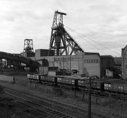


, Armley, Leeds, Yorkshire and sourced from www.leodis.net.")


, Royal Road, Hunslet Carr, Leeds, Yorkshire and sourced from www.leodis.net.")
, Leeds, Yorkshire and sourced from www.leodis.net.")
, Leeds, Yorkshire and sourced from www.leodis.net.")

, Leeds, Yorkshire and sourced from www.leodis.net.")
, Leeds, Yorkshire and sourced from www.leodis.net.")


, Leeds, Yorkshire and sourced from www.leodis.net.")

, Leeds, Yorkshire and sourced from www.leodis.net.")
, Leeds, Yorkshire and sourced from www.leodis.net.")

, Leeds, Yorkshire and sourced from www.leodis.net.")

, Leeds, Yorkshire and sourced from www.leodis.net.")


, Wortley, Leeds, Yorkshire and sourced from www.leodis.net.")


, Wortley, Leeds, Yorkshire and sourced from www.leodis.net.")
, Wortley, Leeds, Yorkshire and sourced from www.leodis.net.")
, New Wortley, Yorkshire and sourced from www.leodis.net.")