


South End of Colliery, Boldon, Co Durham
- Place Picture Notes
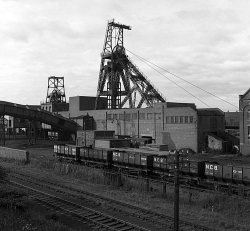
- The pit head at Boldon. The lines in the foreground are a part of the the Tyne Dock to Consett route. The pit was sunk in 1869 and was closed in 1982. It was a lucky pit in that there were no major incidents during its lifetime, although, inevitably enough, it claimed the lives of a number of miners.
- The pit head at Boldon. The lines in the foreground are a part of the the Tyne Dock to Consett route. The pit was sunk in 1869 and was closed in 1982. It was a lucky pit in that there were no major incidents during its lifetime, although, inevitably enough, it claimed the lives of a number of miners.
- Google Map
- Place References (2)
- Parent Place: Co Durham
- 1871 Occupancy/Contact: Cecilia Farrer, Annie Farrer, John Farrer, Ann Waugh (1871 - 1871)